Ferrate nelle Dolomiti Centrali
7
collanasentierid’autore 13 idea Montagna editoria e alpinismo Ferrate nelle Dolomiti Centrali Sassolungo • Sella • Sciliar • Catinaccio • Marmolada • Latemar
-
Upload
idea-montagna-editoria-e-alpinismo -
Category
Sports
-
view
682 -
download
4
Transcript of Ferrate nelle Dolomiti Centrali
collanasentierid’autore 13
idea Montagnaeditoria e alpinismo
Ferrate nelleDolomiti CentraliSassolungo • Sella • Sciliar • Catinaccio • Marmolada • Latemar
5
l Introduzione
Catinaccio, Marmolada, Sella, Sassolungo, Latemar: sono tutti nomi che richiamano spesso
alla mente l’idea stessa delle Dolomiti, toponimi ben impressi nell’immaginario collettivo e
nella mente di escursionisti e alpinisti. Una capillare organizzazione turistica, i numerosi impianti di
risalita, la sterminata rete di punti di appoggio gestiti, fanno delle Dolomiti di Fassa una della aree
più facilmente accessibili dell’intero arco alpino. Molte di queste cime sono entrate tra le immagini
simbolo dei Monti Pallidi, basti pensare alle Torri del Vajolet, al Ghiacciaio della Marmolada, all’Alpe
di Siusi. Le ferrate più famose e tecnicamente impegnative sono tra le più frequentate delle Alpi, so-
prattutto quelle che si sviluppano tra i bastioni di roccia del gruppo del Sella (vero crocevia dei gruppi
dolomitici) come la Ferrata delle Mesules, la Ferrata Piazzetta e la Ferrata Brigata Tridentina, oppure
quelle che risalgono le pareti rocciose del Colac e del Col Ombert. Molti escursionisti scelgono anche
le ferrate del Catinaccio d’Antermoia o il primo tratto del Sentiero Bepi Zac perché, con difficoltà
tecniche contenute, possono compiere escursioni di straordinario fascino.
Cosa resta quindi da consigliare tra queste valli, dove a volte si ha quasi l’impressione di essere ormai
assuefatti alla bellezza e alla sua quotidiana rappresentazione mediatica? Prima di tutto di usare le
ferrate più famose come strumento di conoscenza di alcune della montagne più sorprendenti delle
Alpi e poi di provare a percorrere la panoramica e silenziosa cresta dei Monzoni, tra crinali erbosi,
rocce vulcaniche e memorie della Grande Guerra, di compiere un itinerario di grandissimo respiro
come quello che transita attraverso la Ferrata Ombretta oppure di inoltrarsi nella piccola selva roccio-
sa del gruppo della Vallaccia.
Buona riscoperta.
Andrea Greci
INTRODUZIONE EINFÜHRUNG INTRODUCTIONRosengarten, Marmolata, Sella, Langkofel und Latemar rufen oft typische Dolomitenbilder wach und sind Bergwanderern wie Alpinisten
bestens bekannte, in der kollektiven Vorstellungswelt fest verankerte Begriffe. Ein bis ins Detail organisierter Fremdenverkehr, zahlreiche Seilbahnen und das un-glaublich dichte Netz an Einkehrmöglichkeiten machen die Fassataler Dolomiten zu einem der zugänglichsten Gebiete im Alpenraum. Viele der Dolomitenspitzen, von den Vajolet-Türmen, über den Marmolatagletscher zur Seiseralm, sind längst zum Inbegriff der “Bleichen Berge” geworden. Die bekanntesten und schwierigsten Klettersteige gehören zu den am stärksten begangenen Alpenrouten, dazu gehören besonders die Klettersteige Mesules, Piazzetta und Brigata Tridentina im zentralen Sellastock, oder die Steige entlang der Felswände des Colac bzw. des Col Ombert Viele Bergwanderer ent-scheiden sich auch für die Kesselkogel-Klettersteige oder für den ersten Abschnitt der relativ unschwierigen, aber dafür ausgesprochen reizvollen Tour des Bepi Zac-Wegs. Was kann man in diesen Tälern noch empfehlen, wo einem zuweilen das Gefühl beschleicht, der Schön-heit und der täglichen Mediendarstellung überdrüssig zu werden? Zunächst sollten man die bekannteren Klet-tersteige dazu nutzen, einige der erstaunlichsten Alpen-berge kennenzulernen, und erst später den friedlichen wie panoramareichen Monzoni-Kamm versuchen, wo man auf den grasbewachsenen Kämmen über Vul-kangestein und Kriegserinnerungen stolpert, die wun-derschöne Tour mit dem Ombretta-Klettersteig wagen, oder aber in den kleinen Felswald der Vallaccia-Gruppe eintauchen. Viel Spaß auf der Entdeckungsreise !
Catinaccio, Marmolada, Sella, Sassolungo, Làtemar: never failing to evoke the idea of the Dolomites, these names are firmly imprinted in
the collective imagination and mentality of walkers and climbers. An intricate tourism network, numerous lift systems and the endless huts and rifugios make the Dolomites of the Fassa region one of the most easily accessible areas in the Alps. Many of these peaks have become the symbolic images of the Pale Alps, such as the Vajolet Towers, the Marmolada Glacier and the Alpe di Siusi. The most famous and technically chal-lenging ferratas are also some of the most popular in the Alps, particularly those which develop on the rocky buttresses of the Sella group (a true crossroads of the Dolomites ranges) such as Ferrata delle Mesules, Fer-rata Piazzetta and Ferrata Brigata Tridentina, or those which scale the rock faces of Colac and Col Ombert. Many visitors also choose the ferratas of Catinaccio d’Antermoia or the first section of Sentiero Bepi Zac, enabling extraordinary and fascinating routes at an amenable grade. So what more can we say to recom-mend these valleys, where sometimes it almost feels as though we have grown accustomed to their beauty and daily media presence? First of all, these famous ferratas can be used as a way of getting know some of the most striking mountains in the Alps. Follow the sce-nic and silent Monzoni ridge, explore the grassy crests, volcanic rocks and memories of the Great War, make a breathtaking journey along Ferrata Ombretta or enter into the rocky forest of the Vallaccia group. Embark on a journey of rediscovery.
4
Sentieri d’autore l Ferrate nelle Dolomiti Centrali
7
Sentieri d’autore l Ferrate nelle Dolomiti Centrali
6
Marmolada
CORVARA
Lago diPaneveggio
Lago diFedaia
ARABBA
CAPRILE
CANAZEI
VIGO DI FASSA
MOENA
FALCADE
PREDAZZO
PONTE NOVA
NOVA LEVANTE
SELVA DI VAL GARDENA
Sassolungo
Cima Bocche
Làtemar
Val d'Ega
Val Biois
Catinaccio
Sella
Sciliar
Va l d i T i r e s
Val Pettorina
15
1416 17
12 13
11
30
31
32
33
2627
25
2322
19
18
8
3 7
6
54
1
29
2010
21
24
2829
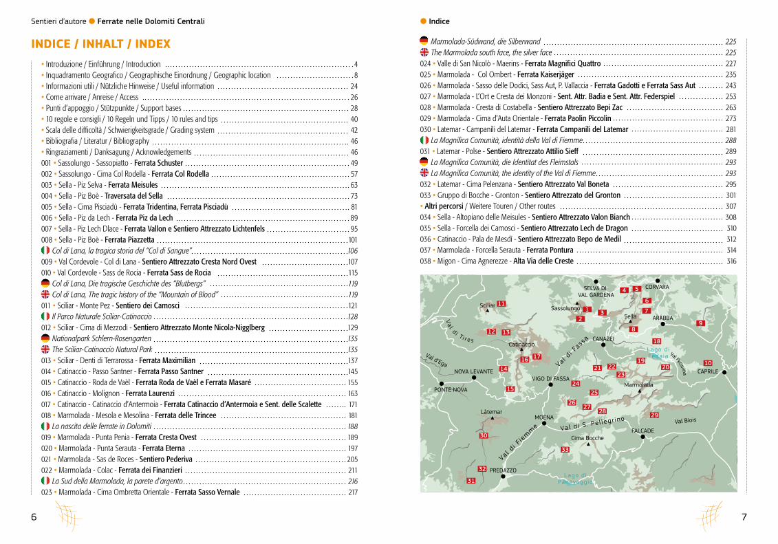
Marmolada-Südwand, die Silberwand 225The Marmolada south face, the silver face 225
024 • Valle di San Nicolò - Maerins - Ferrata Magnifici Quattro 227025 • Marmolada - Col Ombert - Ferrata Kaiserjäger 235026 • Marmolada - Sasso delle Dodici, Sass Aut, P. Vallaccia - Ferrata Gadotti e Ferrata Sass Aut 243027 • Marmolada - L’Ort e Cresta dei Monzoni - Sent. Attr. Badia e Sent. Attr. Federspiel 253028 • Marmolada - Cresta di Costabella - Sentiero Attrezzato Bepi Zac 263029 • Marmolada - Cima d’Auta Orientale - Ferrata Paolin Piccolin 273030 • Latemar - Campanili del Latemar - Ferrata Campanili del Latemar 281
La Magnifica Comunità, identità della Val di Fiemme 288031 • Latemar - Polse - Sentiero Attrezzato Attilio Sieff 289
La Magnifica Comunità, die Identitat des Fleimstals 293La Magnifica Comunità, the identity of the Val di Fiemme 293
032 • Latemar - Cima Pelenzana - Sentiero Attrezzato Val Boneta 295033 • Gruppo di Bocche - Gronton - Sentiero Attrezzato del Gronton 301• Altri percorsi / Weitere Touren / Other routes 307034 • Sella - Altopiano delle Meisules - Sentiero Attrezzato Valon Bianch 308035 • Sella - Forcella dei Camosci - Sentiero Attrezzato Lech de Dragon 310036 • Catinaccio - Pala de Mesdí - Sentiero Attrezzato Bepo de Medil 312037 • Marmolada - Forcella Serauta - Ferrata Pontura 314038 • Migon - Cima Agnerezze - Alta Via delle Creste 316
• Introduzione / Einführung / Introduction 4• Inquadramento Geografico / Geographische Einordnung / Geographic location 8• Informazioni utili / Nützliche Hinweise / Useful information 24• Come arrivare / Anreise / Access 26• Punti d’appoggio / Stützpunkte / Support bases 28• 10 regole e consigli / 10 Regeln und Tipps / 10 rules and tips 40• Scala delle difficoltà / Schwierigkeitsgrade / Grading system 42• Bibliografia / Literatur / Bibliography 46 • Ringraziamenti / Danksagung / Acknowledgements 46001 • Sassolungo - Sassopiatto - Ferrata Schuster 49002 • Sassolungo - Cima Col Rodella - Ferrata Col Rodella 57003 • Sella - Piz Selva - Ferrata Meisules 63004 • Sella - Piz Boè - Traversata del Sella 73005 • Sella - Cima Pisciadù - Ferrata Tridentina, Ferrata Pisciadù 81006 • Sella - Piz da Lech - Ferrata Piz da Lech 89007 • Sella - Piz Lech Dlace - Ferrata Vallon e Sentiero Attrezzato Lichtenfels 95008 • Sella - Piz Boè - Ferrata Piazzetta 101
Col di Lana, la tragica storia del “Col di Sangue” 106009 • Val Cordevole - Col di Lana - Sentiero Attrezzato Cresta Nord Ovest 107010 • Val Cordevole - Sass de Rocia - Ferrata Sass de Rocia 115
Col di Lana, Die tragische Geschichte des “Blutbergs” 119Col di Lana, The tragic history of the “Mountain of Blood” 119
011 • Sciliar - Monte Pez - Sentiero dei Camosci 121Il Parco Naturale Sciliar-Catinaccio 128
012 • Sciliar - Cima di Mezzodì - Sentiero Attrezzato Monte Nicola-Nigglberg 129Nationalpark Schlern-Rosengarten 135The Sciliar-Catinaccio Natural Park 135
013 • Sciliar - Denti di Terrarossa - Ferrata Maximilian 137014 • Catinaccio - Passo Santner - Ferrata Passo Santner 145015 • Catinaccio - Roda de Vaèl - Ferrata Roda de Vaèl e Ferrata Masaré 155016 • Catinaccio - Molignon - Ferrata Laurenzi 163017 • Catinaccio - Catinaccio d’Antermoia - Ferrata Catinaccio d’Antermoia e Sent. delle Scalette 171018 • Marmolada - Mesola e Mesolina - Ferrata delle Trincee 181
La nascita delle ferrate in Dolomiti 188019 • Marmolada - Punta Penia - Ferrata Cresta Ovest 189020 • Marmolada - Punta Serauta - Ferrata Eterna 197021 • Marmolada - Sas de Roces - Sentiero Pederiva 205022 • Marmolada - Colac - Ferrata dei Finanzieri 211
La Sud della Marmolada, la parete d’argento 216023 • Marmolada - Cima Ombretta Orientale - Ferrata Sasso Vernale 217
INDICE / INHALT / INDEX
l Indice
Sentieri d’autore l Ferrate nelle Dolomiti Centrali
154 155
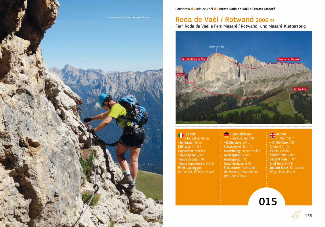
Ascents • Total: 700 m
• On the Wire: 100 mGrade: II 2, II 3Aspect: VariableAscent Time: 5.30 h Descent Time: 1.10 hTotal Time: 6.40 hSupport Bases: Rif. Paolina, Rifugio Roda di Vaèl
Höhendifferenz• Im Aufstieg: 700 m
• Klettersteig: 100 m Schwierigkeit: II 2, II 3Ausrichtung: unterschiedlich Aufstiegszeit: 5,30 h Abstiegszeit: 1,10 h Gesamtgehzeit: 6,40 h Stützpunkte: Paolinahütte (Rif.Paolina), Rotwandhütte (Rif. Roda di Vaèl)
015
Dislivelli • Tot. salita: 700 m
• In ferrata: 100 m Difficoltà: II 2, II 3Esposizione: variabile Tempo salita: 5,30 h Tempo discesa: 1,10 h Tempo complessivo: 6,40 h Punti d’appoggio: Rif. Paolina, Rif. Roda di Vaèl
Roda de Vaèl / Rotwand 2806 mFerr. Roda de Vaèl e Ferr. Masaré / Rotwand- und Masaré-Klettersteig
Attacco
Ferrata Roda de Vael
Roda de Vael
Ferrata del Masarè
Rif. Paolina
Catinaccio l Roda de Vaèl l Ferrata Roda de Vaèl e Ferrata Masaré
Traversi esposti lungo la Ferrata Masarè

Sentieri d’autore l Ferrate nelle Dolomiti Centrali
157156
Ascending to Passo Costalunga from the Val d’Ega, it is impossible not to notice the imposing profile of Roda de Vaèl with its famous “Red Wall” and the aesthetic Masarè ridge. This route reaches the summit of Roda with a lovely circular route, initially tackling the easy North ridge before confronting the airy and more chal-lenging Cresta del Masarè and the eponymous ferrata. For the less experienced, it is equally possible to miss out one of the two routes (in this case, Ferrata Roda de Vaèl is recommended as an introduction to via ferrata).
ACCESSFrom Vigo di Fassa follow the SS241 to Passo Costa-lunga. Cross over the pass and immediately afterwards pass the junction to Passo Nigra and Tires, continuing to descend a short way towards Nova Levante until the large car park of the Paolina chairlift. This can also be reached from the Val d’Ega (SS241) and the Valle di Tires, following Passo Nigra to reach the SS241 of Passo Costalunga just above the lifts. Rifugio Paolina can also be reached on foot, ascending path 552 which departs from Passo Costalunga. In this case allow 1.20 h addi-tional walking time and a further 480 m of ascent.
APPROACHFrom the top station of the chairlift take the path which cuts across the western side of Roda de Vaèl, following the signs for Passo delle Coronelle and Rifugio Fronza (waymarked 552). Continue following the same way-mark, passing the forks with the paths down to the Pas-so Nigra road, to reach another crossroads. This time leave path 552 and turn right towards Passo del Vaiolon (waymarked 549). Make a number of switchbacks to as-cend below the impressive face of the Roda and then at the next fork keep left to ascend towards the wide gully (signs for Ferrata Vaèl). Overcome a vertical section with help from a metal ladder to reach the steep scree slopes of Passo del Vaiolon (2560 m, 1.40 h) where Via Ferrata Roda de Vaèl begins.
Wenn man vom Eggental zum Karerpass herauf-kommt, kommt man nicht umhin, sofort die imposante Silhouette der gefeierten Rotwand, der Roda de Vael, und den schönen Masarè-Gipfelkamm zu bemerken. Diese Rundtour bringt den Bergwanderer zunächst über den leichten Nordgrat und später auf dem lufti-gen Masarè-Grat mit dem anspruchsvolleren Masarè- Klettersteig zum Rotwandgipfel. Weniger Geübten, die nur einen der beiden Klettersteige gehen wollen, wird als Einstieg zunächst der Rotwand-Klettersteig empfoh-len.
ANFAHRTVon Vigo di Fassa aus führt die Staatsstraße 241 zum Karerpass. Hinter der Passhöhe fährt man über die Abzweigung (Nigerpass und Tiers) kurz in Richtung Welschnofen (Nova Levante) bis zum großen Parkplatz an der Talstation des Paolina-Sessellifts. Der Ausgangs-punkt ist auch vom Eggental (Staatsstraße 241) und vom Tierser Tal aus erreichbar, von wo man über den Nigerpass etwas oberhalb der Aufstiegsanlagen auf je-den Fall auf die Karerpassstraße 241 kommt. Der Weg 552 führt auch zu Fuß vom Karerpass zur Paolinahütte. In diesem Fall muss man zusätzlich mit etwa 1,20 h Gehzeit und 480 Höhenmeter Aufstieg rechnen.
ZUSTIEGDen Hinweisen zum Tschagerjoch und zur Kölner Hütte folgend, schlägt man an der Bergstation des Sessellifts den Weg 552 ein, der die Westflanke der Rotwand auf halber Höhe schneidet. Immer der Markierung nach kommt man an Abzweigungen vorbei, die zur Niger-pass-Straße hinunterführen, und gelangt erneut an eine Wegkreuzung, wo es jetzt auf dem Weg 549 nach rechts zum Vaiolonpass geht. Ein paar Serpentinen leiten un-ter die beeindruckende Rotwand und an der folgenden Abzweigung geht man links zur weiten Felsschlucht (Hinweise zum Vaèl-Klettersteig). Hier ist über eine Eisenleiter ein Steilaufschwung zu überwinden, bevor man über steile Geröllfelder zum Rotwand-Klettersteig am Vaiolonpass kommt (2560 m, 1,40 h).
Caratteristici passaggi sulla ferrata Masarè
Salendo al Passo Costalunga dalla Val d’Ega è impossibile non notare la sagoma possente della Roda de Vaèl con la sua celebre “Parete Rossa” e la bella cresta del Masarè. Questo itinerario per-mette di raggiungere la cima della Roda con un bel percorso ad anello prima lungo la sua facile cresta Nord, poi per l’aerea e più difficile Cresta del Masarè dove corre l’omonima ferrata. In alter-nativa, per i meno esperti, è anche possibile per-correre una sola delle due ferrate (come primo approccio si consiglia la Ferrata Roda de Vaèl).
ACCESSODa Vigo di Fassa percorrere la SS241 fino al Passo Costalunga. Oltrepassato il valico e subito dopo il bivio per il Passo Nigra e Tires si scende per un breve tratto in direzione di Nova Levante fino all’ampio parcheggio della Seggiovia Paolina. Il
punto di partenza è raggiungibile anche dalla Val d’Ega (SS241) e dalla Valle di Tires transitando dal Passo Nigra e raggiungendo la SS241 del Passo Costalunga poco a monte della partenza degli im-pianti di risalita. Il Rifugio Paolina è comunque rag-giungibile anche a piedi, salendo lungo il sentiero 552 che parte proprio in corrispondenza del Passo di Costalunga. In questo caso occorre considerare circa 1,20 h di cammino in più e ulteriori 480 m di dislivello positivo.
AVVICINAMENTODall’arrivo della seggiovia si imbocca il sentiero che taglia a mezzacosta il versante occidentale del-la Roda de Vaèl, assecondando le indicazioni per il Passo delle Coronelle e per il Rifugio Fronza (se-gnavia 552). Mantenendo sempre come direzione il segnavia 552, si superano i bivi con le tracce che scendono verso la strada del Passo Nigra, fino a raggiungere un ennesimo crocevia. Questa volta
Catinaccio l Roda de Vaèl l Ferrata Roda de Vaèl e Ferrata Masaré

Sentieri d’autore l Ferrate nelle Dolomiti Centrali
159158
ROUTEThe ferrata ascends the north ridge of the eponymous mountain and does not present any particularly difficult sections. From Passo del Vaiolon cross onto the left side of the ridge then reach the arête of the ridge, alternat-ing between protected sections and a good path which nonetheless requires some caution. Ascend leaning slabs and easy rock steps to reach the summit cross (2806 m, 2.40 h). Descend a path on the opposite side until a new protected section. Follow the cable across easy walls and a short ladder in the base of the gully. A long and challenging exposed traverse left (stemples) leads to a vertical gully which accesses the summit known as Pian de Diaol (2625 m). Skirt the characteris-tic Torre Finestra (Window Tower) and lose height over scree to reach a fork. Turn right (signs) to quickly reach the start of Via Ferrata del Masarè (3.40 h). Descending left, it is also possible to reach Rifugio Roda de Vaèl, taking an easy path where the sole difficulty is a short and narrow chimney protected by wire. From the start of the ferrata follow the cable easily to make a leftwards
WEGVERLAUFDer Klettersteig verläuft am Nordgrat des gleichnami-gen Berges und stellt keine besonderen Anforderungen. Vom Vaialonpass aus, geht man zunächst links vom Grat, später zur Gratkante hinauf, wobei sich gesicherte Steige und Gehgelände (Konzentration!) abwechseln. Nach langem Marsch über plattiges Gelände und leich-te Wandstufen erreicht man das Gipfelkreuz (2806 m, 2,40 h). Auf der gegenüberliegenden Bergflanke führt ein Pfad erneut zu einem Drahtseilsteig hinunter. Am Drahtseil steigt man über einfache Wandstufen und eine kurze Eisenleiter zum Schluchtboden ab. Linkerhand führt eine recht lange, anstrengende und ausgesetzte Querung (Tritthilfen) über eine Steilrinne zum Pian de Diaol (2625 m). Am charakteristischen Fensterlturm vorbei verläuft die Route auf schottrigem Untergrund abwärts zur Abzweigung, wo man rechts (Wegweiser) in kurzer Zeit zum Einstieg des Masarè-Klettersteigs gelangt (3,40 h). Nach links kommt man dagegen zur Rotwandhütte, wobei die einzige Hürde auf dem ansonsten leichten Pfad in einem kurzen und engen
trezzato. Si segue il cavo per facili paretine e una breve scaletta nel fondo del canalone. Un traverso a sinistra più esposto e impegnativo (pioli), prece-de un canaletto verticale che permette di accedere alla sommità denominata Pian de Diaol (2625 m). Costeggiando la caratteristica Torre Finestra, si per-de quota su terreno detritico fino a raggiungere un bivio, dove si volta a destra (cartelli) raggiungendo in breve l’attacco della Ferrata del Masarè (3,40 h). Scendendo invece a sinistra si può raggiungere il Rifugio Roda de Vaèl, percorrendo un sentiero piut-tosto semplice dove l’unica difficoltà è costituita da un breve e stretto camino attrezzato. Dall’attacco della ferrata si segue facilmente il cavo in progres-sivo traverso verso sinistra, si attraversa un cana-le detritico e si raggiunge la base di un tratto più ripido. Superato un canale caratterizzato da rocce levigate, si sale per un lungo tratto alternando co-modi traversi, paretine e caminetti più verticali ma sempre ben gradinati. Dopo una madonnina si rag-
si abbandona il segnavia 552 e si piega a destra verso il Passo del Vaiolon (segnavia 549). Si sale con alcuni tornanti sotto l’impressionante parete della Roda e al bivio successivo si tiene la sinistra salendo verso l’ampio canalone (indicazioni Fer-rata Vaèl). Superato un salto verticale con l’aiuto di una scaletta metallica si raggiunge, per ripide ghiaie, il Passo del Vaiolon (2560 m, 1,40 h) dove inizia la Ferrata Roda de Vaèl.
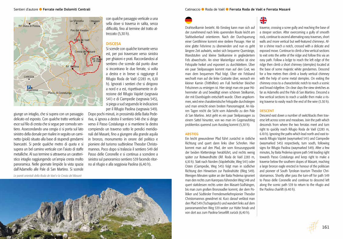
ITINERARIOLa ferrata sale la cresta nord dell’omonima monta-gna e non presenta difficoltà particolari. Dal Passo del Vaiolon si traversa sul lato sinistro della cresta, quindi se ne raggiunge il filo alternando tratti at-trezzati a un comodo sentiero che richiede comun-que attenzione. Salendo lungamente per placche appoggiate e facili gradoni, si raggiunge la croce di vetta (2806 m, 2,40 h). Su sentiero si scende sull’opposto versante fino a un nuovo tratto at-
Breve tratto attrezzato nel canalone verso il Passo del Vaiolon Lungo la cresta della Ferrata Roda de Vaèl
Lungo la cresta della Ferrata Masarè
Catinaccio l Roda de Vaèl l Ferrata Roda de Vaèl e Ferrata Masaré
Sentieri d’autore l Ferrate nelle Dolomiti Centrali
161160
traverse, crossing a scree gully and reaching the base of a steeper section. After overcoming a gully of smooth rock, continue to ascend alternating easy traverses, short walls and more vertical but well-featured chimneys. Af-ter a shrine reach a notch, crossed with a delicate and exposed move. Continue to climb a few vertical sections to exit onto the arête of the ridge and follow this via an easy path. Follow a ledge to reach the left edge of the ridge then climb a short chimney (stemples) located at the base of some majestic white gendarmes. Descend for a few metres then climb a lovely vertical chimney with the help of some metal stemples. On exiting the chimney cross to a characteristic notch to reach a scenic and broad ridgeline. On clear days the view stretches as far as Adamello and the Pale di San Martino. Descend a few vertical sections to reach a saddle then make a ris-ing traverse to easily reach the end of the wire (5.30 h).
DESCENTDescend east down a number of switchbacks then trav-erse left across scree and meadows. Join the path which descends from where the two ferratas meet and turn right to quickly reach Rifugio Roda de Vaèl (2283 m, 6.10 h). Ignoring the paths which lead north and east to-wards Rifugio Vajolet (waymarked 541) and Ciampedie (waymarked 545) respectively, turn south, following signs for Rifugio Paolina (waymarked 549). After a few minutes, by Baita Pederiva ignore path 548 leading right towards Passo Costalunga and keep right to make a traverse below the southern slopes of Masarè, reaching a large bronze eagle erected in honour of the politician and pioneer of South Tyrolean tourism Theodor Chri-stomannos. Shortly after pass the turn-off for path 549 to Passo delle Coronelle and continue to descend left along the scenic path 539 to return to the rifugio and the Paolina chairlift (6.40 h).
Drahtseilkamin besteht. Ab Einstieg kann man sich auf der zunehmend nach links querenden Route leicht am Stahlseilverlauf orientieren. Nach der Durchquerung einer Geröllrinne kommt eine steilere Passage. Hier ist eine glatte Felsrinne zu überwinden und nun es geht längere Zeit aufwärts, wobei sich bequeme Quersteige, Wandstufen und kleine Steilkamine in gegliedertem Fels abwechseln. An einer Marienfigur vorbei ist eine Felsspalte heikel und esponiert zu durchklettern. Über ein paar Steilpassagen kommt man auf den Grat, wo man dem bequemen Pfad folgt. Über ein Felsband wechselt man auf die linke Gratseite über, wonach ein kleiner Kamin (Tritthilfen) am Fuß herrlicher bleicher Felszinnen zu ersteigen ist. Hier steigt man ein paar Hö-henmeter ab und bewältigt einen schönen Steilkamin, der mit Eisenbügeln entschärft wurde. Oben angekom-men, wird eine charakteristische Felsspalte durchstiegen und man erreicht einen breiten Panoramagrat. An kla-ren Tagen reicht die Sicht vom Adamello zu den Pale di San Martino. Jetzt geht es ein paar Steilpassagen zu einem Sattel hinunter, von wo man im Gegenaufstieg problemlos querend zum Ausstieg kommt (5,30 h).
ABSTIEGEin leicht gewundener Pfad führt zunächst in östliche Richtung und quert dann links über Schrofen. Hier kommt man auf den Pfad, der vom Kreuzungspunkt der beiden Klettersteige herabführt, und rechts wenig später zur Rotwandhütte (Rif. Roda de Vaèl 2283 m, 6,10 h). Statt nach Norden (Vajolethütte, Weg 541) oder Osten (Ciampedie, Weg 545) folgt man in südlicher Richtung den Hinweisen zur Paolinahütte (Weg 549). Wenigen Minuten später an der Baita Pederiva ignoriert man den rechts zum Karerpass führenden Weg 548 und quert stattdessen rechts unter den Masarè-Südhängen, bis man zum großen Bronzeadler kommt, der dem Po-litiker und Südtiroler Fremdenverkehrspionier Theodor Christomannos gewidmet ist. Kurz darauf verlässt man den Pfad 549 (Tschagerjoch) und wandert links auf dem panoramareichen Weg 539 weiter zur Hütte hinab und von dort aus zum Paolina-Sessellift zurück (6,40 h).
con qualche passaggio verticale a una sella dove si traversa in salita, senza difficoltà, fino al termine del tratto at-trezzato (5,30 h).
DISCESASi scende con qualche tornante verso est, per poi traversare verso sinistra per ghiaioni e prati. Raccordandosi al sentiero che scende dal punto dove si incontrano le due ferrate, si volta a destra e in breve si raggiunge il Rifugio Roda de Vaèl (2283 m, 6,10 h). Ignorati i sentieri che si dirigono a nord e a est, rispettivamente in di-rezione del Rifugio Vajolet (segnavia 541) e di Ciampedie (segnavia 545), si piega a sud seguendo le indicazioni per il Rifugio Paolina (segnavia 549).
Dopo pochi minuti, in prossimità della Baita Pede-riva, si ignora a destra il sentiero 548 che si dirige verso il Passo Costalunga e si mantiene la destra compiendo un traverso sotto le pendici meridio-nali del Masarè, fino a giungere alla grande aquila in bronzo, monumento in onore del politico e pioniere del turismo sudtirolese Theodor Christo-mannos. Poco dopo si tralascia il sentiero 549 del Passo delle Coronelle e si continua a scendere a sinistra sul panoramico sentiero 539 facendo ritor-no al rifugio e alla seggiovia Paolina (6,40 h).
giunge un intaglio, che si supera con un passaggio delicato ed esposto. Con qualche tratto verticale si esce sul filo di cresta che si segue per comodo sen-tiero. Assecondando una cengia ci si porta sul lato sinistro della dorsale per risalire in seguito un cami-netto (pioli) situato alla base di stupendi gendarmi biancastri. Si perde qualche metro di quota e si supera un bel camino verticale con l’aiuto di staffe metalliche. Al suo termine si attraversa un caratteri-stico intaglio raggiungendo un’ampia cresta molto panoramica. Nelle giornate limpide la vista spazia dall’Adamello alle Pale di San Martino. Si scende
Le pareti orientali della Roda de Vael e la Cresta del Masarè
6A
6A
1A
1A
9
16
6
1A
552549
551
549
541
539
548
13
549
552
Roda de Vaèl
Rif. Rodadi Vaèl
La Sforcella I Mugoni
Cresta de Masarè
Rif. Paolina
CAREZZA
Alpenrose
Rif. Duca di Pistoia
Pas dal Vaiolon
Passo di Costalunga
Catinaccio l Roda de Vaèl l Ferrata Roda de Vaèl e Ferrata Masaré