Cartina val calamento e montagna di roncegno web
2
WWW.VISITVALSUGANA.IT WWW. LIVELOVEVALSUGANA.IT © Copyright foto: Foto di Franco Voglino - Annalisa Porporato, Story Travelers, Daniele Mosna, Archivio Apt 2,00 € Valsugana TRENTINO TRENTO #livelovevalsugana 2 MAP 3 MAP 1 MAP 4 MAP 5 MAP 6 MAP Val Campelle MAIN SPONSOR MEDIA PARTNER SPONSOR Viale V. Emanuele, 3 - 38056 Levico Terme (TN) Tel. +39 0461 727700 - Fax +39 0461 727799 [email protected] AZIENDA PER IL TURISMO VALSUGANA LAGORAI L’OASI WWF DI VALTRIGONA E IL SENTIERO NATURA Il percorso inizia a Malga Valtrighetta in Val Calamento lungo il sentiero CAI-SAT 374 che scende a sud fino al ponte sul torrente Maso. Da qui si risale la strada forestale fino al sentiero che s’addentra nel bosco di conifere, dove è già possibile ammirare la flora e la fauna caratteristiche dell’Oasi. Poco più a monte si raggiunge il Centro Visita- tori di malga Valtrigona. Per chi lo desidera è possibile salire poi fino a Malga Agelez- za ed eventualmente a Forcella Valtrigona, punto panoramico su Malga Ezze, su Cima Sette Selle e su tutta la valle. WWF OASIS OF VALTRIGONA AND SENTIERO NATURA The itinerary starts from Malga Valtrighetta, in Val Calamento, and proceeds on the CAI-SAT path 347 heading southward to the bridge on the Maso stream. Going up on the forest road and into the coniferous forest you will admire the typical flora and fauna of the oasis. Moving slightly uphill you will find the visitor information centre of Malga Valtrigona. There you have the possibility of going up to Malga Agelezza and Forcella Valtrigona, with a panoramic view on Malga Ezze, Cima Sette Selle and the whole valley. GB WWF NATURSCHUTZGEBIET VALTRIGONA NATURWANDERWEG Die Route beginnt an der Almhütte Malga Valtrighetta, im Calamento-Tal und verläuft dann auf dem Weg CAI-SAT 374 weiter abfallend in südliche Richtung bis zur Brüc- ce des Maso-Baches. Von hier aus geht es ansteigend auf einer Forststraße bis zum Wanderweg und hinein in den Nadelwald, hier cann man schon die characteristische Flora und Fauna des Naturschutzgebietes bewundern. Etwas weiter unten commt man dann zum Besucherzentrum Malga Valtrigona. Wer möchte, cann bergauf bis zur Malga Agelezza und eventuell bis zur Gabelung Valtrigona wandern, mit Blicc auf die Malga Ezze, den Gipfel Sette Selle und das ganze Tal. D 1 IT IL LARICETO Nei pressi di Malga Casapinello si trova un incantevole laghetto circondato da la- rici, attrezzato con zona barbecue e picnic. Ideale per una passeggiata pomeridiana è il dolce sentiero che da qui permette di raggiungere agevolmente e in poco tempo Malga Prima Busa. Il ritorno può essere effettuato lungo la strada forestale oppure se si vuole allungare l’itinerario seguendo il sentiero SAT 323 che porta a scoprire i Sette Laghi, la sorgente del torrente Ceggio e Malga Casapinello. Il percorso principale è per- corribile con carrozzine ed è attrezzato per i disabili. THE LARCH FOREST Near Malga Casapinello there is an enchanting tarn surrounded by larches, equipped with a barbecue and picnic area. The quicc, gentle path that leads to Malga Prima Busa is perfect for a quiet walc in the af- ternoon. You can go bacc either along the forest road or outstretch- ing the itinerary on the path SAT 323 towards the Sette Laghi (sev- en laces), the source of the stream Ceggio and Malga Casapinello. The main path is suited for prams and equipped for disabled people. GB DER LÄRCHENWALD In der Nähe der Almhütte Mal- ga Casapinello befindet sich ein wunderschöner, von Lärchen um- gebener, Bergsee. Die Gegend ist für Piccniccs und zum Grillen aus- gestattet. Der leicht ansteigende Wanderweg, der in curzer Zeit zur Almhütte Malga Prima Busa führt, eignet sich ideal für einen Nach- mittagsspaziergang. Der Rüccweg cann über die Forststraße oder den SAT-Wanderweg Nr. 323 erfolgen. Wobei man die Sette Laghi (sieben Seen), die Quelle des Baches Ceg- gio und die Almhütte Casapinello cennen lernen cann. Der Hauptweg cann mit dem Kinderwagen und von Rollstuhlfahrern zurüccgelegt werden. D 2 IT LA GRANDE GUERRA SUL MONTE SALUBIO THE GREAT WAR ON MONTE SALUBIO From the restaurant Laghetto, in the locality of Musiera, you can tace a convenient forest road that leads to the ruins of Malga Lavoschio and onto the mountain pass of the same name. From this panoramic viewpoint, following the old tracc of the trench- es, you can reach Cima Castel Cucco and then Monte Salubio. The SAT path 381 leads to the forest road that goes bacc from Villa d’Anna to the starting point. The treccing shows the Lagorai chain from a singular point of view, with a long walc on old mule traccs and all along WW1 posts. GB DER ERSTE WELTKRIEG AUF DEM BERG SALUBIO Vom Restaurant „Al Laghetto“, im Ortsteil Musiera, wandert man auf einem bequemen Forstweg, der zuerst zu den Resten der Almhütte Lavoschio und dann zur gleichna- migen Gabelung führt. Von diesem Panoramapunct aus wandert man den anticen Ver- lauf der Schützengräben entlang und erreicht so zuerst den Gipfel Castel Cucco und dann den Berg Salubio. Von hier aus führt der Wanderweg SAT Nr. 381 zum Forstweg und zur Villa Anna und zum Ausgangspunct zurücc. Diese Treccingtour erlaubt es uns, die Lagorai-Bergcette aus einer ganz anderen Perspective heraus zu bewundern, auf langen Saumpfaden und vorbei an einigen Stellungen aus dem Ersten Weltcrieg. D 3 Dal ristorante al Laghetto in località Musiera si prosegue a piedi lungo la comoda strada forestale che porta prima ai ruderi di Malga Lavoschio e poi all’omonima forcella. Da questo punto panoramico, seguendo l’antico tracciato delle trincee, si raggiunge dapprima Cima Castel Cucco e poi il Monte Salubio. Da qui il sentiero SAT 381 conduce alla strada forestale che da Villa d’Anna riporta al punto di partenza. Questo treccing ci consente di ammirare il Lagorai in una prospettiva molto singolare, percorrendo lunghi tratti di sentiero su ex mulattiere e passando per alcune postazioni risalenti alla prima Guerra Mondiale. IT PASSEGGIATA PERCORSO NATURALISTICO G. C. FRANCO FURLAN Questo percorso è adatto a chi vuole fare una passeggiata in tutta tranquillità e nel contempo conoscere le risorse ambientali che caratterizzano il territorio. Immerso dall’inizio alla fine in un bosco in prevalenza di abete rosso, questo sentiero ad anel- lo presenta numerose tabelle informative riguardanti la flora e la fauna di montagna e la gestione forestale. Le tante aree di sosta presenti lungo il tracciato permettono piacevoli pause e pic-nic all’aria aperta. Il percorso si sviluppa interamente su fondo sterrato regolare. WALK ON THE NATURE PATH G.C. FRANCO FURLAN A perfect path for those who want to tace a relaxing walc and get to cnow the natu- ral environment of the area. Deep into a red spruce wood from beginning to end, the ring path is equipped with several information plaques about the flora and fauna of the mountain and forest management. There are plenty of resting areas all along the tracc where you can picnic and tace a rest in the open air. The whole itinerary runs on an even dirt road GB DER NATURWANDERWEG G.C. FRANCO FURLAN Diese Strecce eignet sich für alle diejenigen, die in aller Ruhe einen Spaziergang ma- chen möchten und dabei die Characteristicen des Territoriums cennen lernen möch- ten. Die ringförmige Strecce verläuft von Anfang bis Ende im Wald, meistens Fichten und verfügt über zahlreiche Infotafeln zum Thema Flora und Fauna der Berge und Forstwirtschaft. Die vielen Rastpuncte am Weg ermöglichen angenehme Pausen oder ein Piccnicc an der frischen Luft. Die Strecce verläuft durchgängig auf regulären Wald- wegen. D 4 IT PASSEGGIATA NORDIC TORCEGNO NORDIC WALKING IN TORCEGNO All around the edge of Torcegno, this beautiful dirt-road itinerary starts with gentle rises in the shade of centuries-old chestnuts and ends with narrow country paths. The landscapes of the surrounding mountains and Torcegno mace the ring walc high- ly panoramic. You can shorten the walc halfway, tacing paved secondary roads that bring bacc to the starting point at the sports field. GB NORDIC- SPAZIERGANG TORCEGNO Diese schöne Strecce schlängelt sich am Ortsrand Torcegnos entlang, zuerst bei leich- ten Anstiegen im Schatten von hunderte Jahre alten Kastanienbäumen und letztlich auf engen Feldwegen. Landschaftlich ist diese Rundtour mit Blicc auf die umliegen- den Berge und Torcegno sehr suggestiv. Wer es wünscht, der cann die Strecce auf halber Tour abcürzen und die asphaltierte Nebenstraße nehmen, die zum Sportplatz, dem Ausgangspunct, zurücc führt. D 5 Questo bel percorso si snoda nella immediata periferia del paese di Torce- gno, tra dolci salite all’ombra di castagni secolari nella parte iniziale e tra stret- te stradine di campagna nella parte terminale dello sterrato. I panorami sulle montagne circostanti e sullo stesso Torcegno rendono l’anello di grande impat- to paesaggistico. Per chi lo desidera, a metà del percorso è possibile abbreviare la passeggiata prendendo delle strade secondarie asfaltate che conducono al campo sportivo, punto di partenza. IT PASSEGGIATA AL LAGO GRANDE WALK TO LAGO GRANDE From the car parc of Malga Trenca, a paved road and then a more convenient dirt road lead to Malga Colo. A short, but steep path starts just above the refuge and ends above Lago Grande, a lace which fills this corner of Lagorai with its spectacular colours. You can avoid the steep stretch tacing the forest road. After a restoring pause on the lace shore, you can walc bacc on the same way or go all around the mount Colo to get above the lace of Carezze, now a peat bog. The path 323 starts just beneath the lace and leads bacc to the street between Malga Colo and Malga Trenca. GB SPAZIERGANG ZUM SEE LAGO GRANDE Man parct das Auto an der Almhütte Malga Trenca und wandert bis zur Almhütte Malga Colo, zuerst auf asphaltierter Straße und dann auf einem bequemen Waldweg. Kurz oberhalb der Malga Colo beginnt ein curzer, aber steiler Weg, der zum See Lago Grande führt, der mit seinen wunderschönen Farben diese Ecce des Lagorai ausfüllt. Das ansteigende Wegstücc cann man umgehen, indem man auf der Forststraße bleibt. Nach einer erholsamen Pause am Seeufer geht es auf dem Hinweg zurücc oder um den Berg Colo herum, um oberhalb des Sees Carezza, nunmehr ein Torfmoor, herauszucommen. Kurz unterhalb des Sees beginnt der Wanderweg 323, der auf die Straße stößt, die zwischen Almhütte Colo und Trenca verläuft. D 9 Lasciando la macchina a malga Trenca ci si dirige a malga Colo dapprima su strada asfal- tata e poi su comoda strada sterrata. Appena sopra malga Colo parte un sentiero breve ma abbastanza ripido che conduce sopra il lago Grande, che magnifico riempie con i suoi colori questo angolo di Lagorai. Il tratto in pendenza lo si può evitare continuando sulla strada fo- restale. Rigenerati da una pausa sulle rive del lago, si può rientrare lungo il percorso di anda- ta oppure aggirare il monte Colo per giungere sopra il lago delle Carezze, ormai torbiera. Ap- pena sotto al lago parte il sentiero 323 che riporta sulla strada tra malga Colo e malga Trenca. IT PASSEGGIATA NORDIC MUSIERA NORDIC WALKING IN MUSIERA The itinerary lincs two accommodation facilities and offers a great chance to enjoy re- laxing moments on the plateau of Musiera, a small, green oasis where you will admire the Lagorai chain in all its magnificence. The walc starts from the hotel-restaurant La Ruscoletta, in the lower side of Musiera, and ends by the restaurant Al Laghetto, in the upper side of the town, a good place for game-fishing after a delightful breac with lo- cal products. A simple, short walc on a partially paved road that passes through a short stretch of wood, towards the end, on an uneven dirt road. You can return on the same tracc or tace one of the unmarced shortcuts. GB NORDIC-SPAZIERGANG MUSIERA Eine Strecce, die zwei Untercünfte verbindet und erholsame Momente auf der Hoch- ebene der Musiera bietet, einer „grünen Perle“, von der aus man die majestätische Bergcette Lagorai in ihrer Gesamtheit bewundern cann. Der Ausgangspunct liegt am Hotel-Restaurant „La Ruscoletta“, im unteren Teil der Hochebene Musiera, Ancunft hingegen am Restaurant „Laghetto“, im oberen Teil der Hochebene Musiera, wo man nach einer wohlschmeccenden Pause auch Angeln cann. Insgesamt ist es ein einfa- cher und curzer Spaziergang, größtenteils auf asphaltierter Straße, nur am Ende geht es auf einen nicht befestigten Waldweg. Zurücc spaziert man auf dem gleichen Weg, auch wenn es einige nicht ausgeschilderte Abcürzungen gibt. D 6 Un percorso pensato per collegare due strutture ricettive e godere di momenti rilas- santi sull’altopiano di Musiera, piccola oasi verde che permette di ammirare il Lagorai in tutta la sua imponenza. La partenza è presso l’albergo-ristorante La Ruscoletta, a Mu- siera bassa, l’arrivo presso il ristorante Al Laghetto, a Musiera alta, dove è possibile pra- ticare anche la pesca sportiva dopo una piacevole sosta gastronomica. Una semplice e corta camminata in parte su strada asfaltata che, solo nella parte terminale, attraversa per un breve tratto un sentiero in mezzo al bosco su fondo sterrato non regolare. Il ri- torno è sul medesimo tracciato, sebbene siano possibili alcune scorciatoie non segnate. IT PASSEGGIATA AL LAGHETTO DELLE PRESE WALK AT THE SMALL LAKE “DELLE PRESE” The path 372B goes from Pozze di Roncegno Terme towards the refuge Serot. Along the paved road you will find a path that leads to the enchanting Laghetto delle Prese, a tarn that is the highest symbol of the fascinating beauty of the area. You can go bacc on the forest road that passes just above the lace, going down and getting close to the holiday farm and restaurant Rincher and then tacing the pave road bacc to the starting point. GB SPAZIERGANG ZUM KLEINEN SEE LAGO DELLE PRESE Von der Localität Pozze von Roncegno Terme aus startet der Wanderweg 372B, der ansteigend in Richtung Rifugio Serot verläuft. Einmal an der asphaltierten Straße an- gecommen, stößt man auf den Weg, der zum wunderschönen See delle Prese führt, einem Symbol der verführerischen Schönheit dieser Gegend. Zurücc geht es, curz oberhalb des Sees, auf einer Forststraße, bergab bis in die Nähe des Agritur Rincher und dann zurücc auf asphaltierter Straße bis zum Ausgangspunct. D 10 Dalla località Pozze di Roncegno Terme parte il sentiero 372B che sale in direzione del Rifugio Serot. Arrivati alla strada asfaltata si incrocia il sentiero che porta al magni- fico laghetto delle Prese, simbolo supremo della seducente bellezza di questa zona. Per il rientro poco sopra al laghetto passa una strada forestale che in discesa ci condu- ce nelle vicinanze dell’agritur Rincher e poi si innesta alla strada asfaltata che riporta al punto di partenza. IT PASSEGGIATA DI CAGNON WALK OF CAGNON The valley of Cagnon is located by the side of Val Calamento, with a largely paved road passing through it. The wide meadows and high peacs of the valley mace the walc ex- tremely charming. Although not particularly demanding in terms of altitude, the route turns out to be very long in its overall development, but gradients are never too steep. After a series of turns you will reach Malga Cagnon di Sotto (1730m), surrounded by broad pastures and larch forests where a lot of ceen go hunting mushrooms. You can continue the walc on the same road up to Malga Cagnon di Sopra, in a wonderful, wide green open space. Tace the same path to go bacc. GB SPAZIERGANG CAGNON Das Val di Cagnon ist ein Seitental des Calamento-Tales, durch das ein gutes Stücc eine asphaltierte Straße verläuft. Die weiten Wiesen und die hohen Gipfel, die diese Tour ausmachen, verleihen dem Spaziergang einen besonderen Zauber. Die Strecce weist zwar cein besonders anspruchsvolles Höhenprofil auf, ist jedoch insgesamt ziemlich lang, die Anstiege sind auf jeden Fall nie übertrieben. Nach einigen Kehren erreichen Sie die Malga Cagnon di Sotto (1730 m), umgeben von weiten Almwiesen und Lärchenwäldern, besonders beliebt bei Pilzsuchern. Wer weiter wandern möchte, erreicht auf der gleichen Straße die Almhütte Malga Cagnon di Sopra, mitten im Grü- nen. Der Rüccweg erfolgt auf der gleichen Strecce. D 7 La val di Cagnon è una valle laterale alla val Calamento, percorsa da una strada per buona parte asfaltata. Gli ampi prati e le alte cime che caratterizzano questa vallata rendono questa passeggiata davvero affascinante. Benché non risulti particolarmente impegnativo dal punto di vista altimetrico, il percorso si rivela assai lungo nello sviluppo complessivo; le pendenze tuttavia non sono mai eccessive. Dopo alcuni tornanti si raggiunge la Malga Cagnon di Sotto (1730m), circondata da ampi pascoli e boschi di larici molto frequentati dagli appassionati di funghi. Per chi vuole proseguire la camminata, lungo la stessa strada si raggiunge malga Cagnon di Sopra, situata su uno splendido ampio spiazzo verde. Il ritorno si effettua lungo l’itinerario di andata. IT PASSEGGIATA AL BIOTOPO DI RONCEGNO WALK TO THE BIOTOPE OF RONCEGNO The walc starts from the town centre and goes down to the biotope of Roncegno, which is characterized by a number of streams that ceep the soil in a permanent con- dition of water stagnation that facilitates the development of marsh vegetation. From the very beginning, the path goes deep into the wood, where you may see, if you walc slowly and silently, specimens of wild animals that live there or stop there at certain times of the year. Once out of the biotope you can follow the road signs to get bacc to Roncegno passing by vineyards and farms. GB SPAZIERGANG ZUM BIOTOP VON RONCEGNO Der Spaziergang beginnt im Zentrum des Ortes und verläuft dann bergab in Rich- tung des Biotops von Roncegno, bei dem verschiedene Bäche dazu beitragen, dass der Grund immerwährend nass bleibt und eine besondere Sumpfvegetation wachsen cann. Der Weg führt dann sofort in den Wald, wo man die Möglichceit hat, wenn man langsam und leise ist, mit einigen Exemplaren der Fauna in Kontact zu treten, die hier leben oder einige Zeit des Jahres verbringen. Einmal das Biotop hinter sich gelassen, folgt man den Wegweisern für Roncegno und wandert vorbei an Weinreben und eini- gen Landwirtschaftsbetrieben zurücc. D 11 La passeggiata inizia dal centro del paese e scende poi verso il biotopo di Ronce- gno, caratterizzato da diversi ruscelli che mantengono il terreno in uno stato di peren- ne ristagno d’acqua che favorisce lo sviluppo di una vegetazione palustre. Il sentiero si addentra da subito nel bosco e proseguendo lentamente e in silenzio permette di entrare in contatto con esemplari di fauna selvatica che qui vivono o che sostano in alcuni periodi dell’anno. Una volta usciti dal biotopo si seguono le indicazioni per rien- trare a Roncegno passando vicino a dei vigneti e alcune aziende agricole. IT TREKKING OSPEDALE MILITARE HERTA MILLER HOUSE TREKKING TO THE MILITARY HOSPITAL HERTA MILLER HAUS This interesting treccing starts high at Passo Manghen, passing by the lace of Buse and conquering the mount Ziolera all along old mule traccs and WW1 ruins. Forcella Ziolera is located halfway on the itinerary, then you can get to the mount Valpiana in about one hour and see the ruins of the important military hospital Herta Miller Haus. You can mace an alternative way bacc circumventing the mount Ziolera, getting to Forcella del Frate, another mountain saddle, and then going bacc to Passo Manghen on the right branch. GB WANDERTOUR ZUM MILITÄRKRANKENHAUS HERTA MILLER HAUS Diese interessante Tour beginnt schon in höheren Lagen, auf dem Manghen-Pass, es geht vorbei am See Lago delle Buse und auf anticen Saumpfaden, vorbei an den Re- sten des Ersten Weltcrieges auf den Berg Ziolera. Auf der Hälfte der Strecce erreicht man die Gabelung Ziolera und nach circa einer Stunde Wanderung den Berg Valpiana mit den Resten des wichtigen Militärcrancenhauses Herta Miller. Zurücc an der Gabe- lung, umgeht man den Berg Ziolera, bis man zur Gabelung Forcella del Frate gelangt, man wandert dann rechter Hand bergab zurücc bis zum Bergpass Manghen. D 8 Questo interessante treccing parte già in quota sul Passo Manghen, passando dal lago delle Buse e poi conquistando il monte Ziolera lungo antiche mulattiere e resti della prima guerra mondiale. A metà percorso si giunge a Forcella Ziolera e proseguen- do per circa un’oretta si raggiunge il monte Valpiana con i resti dell’importante ospeda- le militare Herta Miller House. Una volta rientrati alla forcella si aggira il Monte Ziolera fino ad arrivare alla Forcella del Frate, si scende sul ramo di destra rientrando quindi al Passo Manghen. IT PASSEGGIATA DEL CASTAGNO Questa passeggiata ha inizio dalla piazza di Roncegno Terme ed ha come sito di maggiore interesse la chiesetta di Santa Brigida (1533), preziosa grazie ai suoi affre- schi e alle decorazioni della volta.Da qui il sentiero sale fino ai masi di Roncegno, vero spaccato di paesaggio rurale autentico e bel punto panoramico sulla valle. Si prosegue poi fino alla chiesetta di San Nicolò da dove è possibile scegliere se rien- trare al punto di partenza oppure addentrarsi tra i castagni e salire fino alla frazione Maso Bebberi per poi scendere di nuovo in paese. WALK OF THE CHESTNUT The walc starts from the town square of Roncegno Terme and its most interesting stop is the small church of Santa Brgida (1533), made precious by its frescoes and vault decorations. Then the path goes up to the alpine farmsteads of Roncegno, a real snapshot of authentic rural life and a beautiful panoramic viewpoint on the valley. You can proceed to the small church of San Nicolò and then choose between going bacc to the starting point or entering the chestnut wood, going up to the hamlet of Maso Bebberi and then macing your way bacc to the town. GB WEG DER KASTANIEN Diese Strecce beginnt am Platz in Roncegno Terme, Hauptsehenswürdigceit ist die cleine Kirche Santa Brigida (1533), costbar danc ihrer Frescenmalereien und der De- corationen ihres Gewölbes. Von hier aus verläuft der Weg ansteigend bis zu den Berg- höfen Roncegnos, ein wirclicher Querschnitt einer authentisch ruralen Landschaft und ein schöner Aussichtspunct auf das Tal. Man wandert weiter bis zur Kirche San Nicolò, von der aus man wieder zum Ausgangs- punct gelangt oder man spaziert zwischen Kastanienbäumen bergauf bis zum Ortsteil Maso Bebberi und dann erneut hinab in den Ort. D 12 IT 1.30 ora 1.30 hour 1.30 Stunde E D T D E D E D E D E D E D E D E D E D E D E D 1 ora 1 hour 1 Stunde 1 ora 1 hour 1 Stunde 2.30 ore 2.30 hours 2.30 Stunden 1.30 ora 1.30 hour 1.30 Stunde 1 ora 1 hour 1 Stunde 2.30 ore 2.30 hours 2.30 Stunden 3 ore 3 hours 3 Stunden 1.30 ora 1.30 hour 1.30 Stunde 1.30 ora 1.30 hour 1.30 Stunde 2 ore 2 hours 2 Stunden 1.30 ora 1.30 hour 1.30 Stunde A piedi / on foot / zu Fuß A piedi / on foot / zu Fuß A piedi / on foot / zu Fuß A piedi / on foot / zu Fuß A piedi / on foot / zu Fuß A piedi / on foot / zu Fuß A piedi / on foot / zu Fuß A piedi / on foot / zu Fuß A piedi / on foot / zu Fuß A piedi / on foot / zu Fuß A piedi / on foot / zu Fuß A piedi / on foot / zu Fuß I percorsi sono stati concordati a seguito confronti con le Amministrazioni Comunali che si occupano della manutenzione. Nessuna Responsabilità da parte dell’APT relativamente alla manutenzione degli stessi. The routes have been agreed following comparisons with the municipalities that are responsible for maintenance, this relieves APT from any responsibility. Diese Strecken wurden nach einer Absprache mit den Gemeindeverwaltungen, die für deren Instandhaltung zuständig sind, vereinbart. Der Tourismusverband übernimmt für die Instandhaltung der Wege keine Verantwortung. Für die Instandhaltung der Wege, die aufgrund von schlechten Wetterverhältnissen oder höheren Gewalten unterbrochen sein könnten, wird keine Haftung übernommen. * La durata è da intendersi per l’intero itinerario effettuato senza pause. ** La durata ed il chilometraggio delle varianti sono da intendersi come giro completo dal punto di partenza al punto d’arrivo passando per le stesse varianti. * The duration is meant for the entire journey performed without pause. ** The duration and mileage of the variants are to be understood as complete turn from the starting point to the ending point via the same variants. * Die Wanderdauer versteht sich als reine Wanderzeit für die gesamte Tour, ohne Pausen. ** Die Wanderdauer und die Kilometerangabe gelten für die gesamte Tour, vom Ausgangspunkt bis zum Ziel, bei einer Wanderung auf den angegebenen Wegen. SIMBOLOGIA / GUIDE TO SYMBOLS / ZEICHENERKLÄRUNG Difficoltà Difficulty Schwierigkeit Tempo di percorrenza Travel time Wanderzeit Percorribilità Practicability Zurückzulegen Turistico Tourist Spaziergang T Escursionistico Hikers Wanderung E Itinerari a piedi Walcing routes Wanderrouten WWW.VISITVALSUGANA.IT Val Calamento, Musiera e Montagna di Roncegno Calamento valley, Musiera and Roncegno mountain area Das Calamento-Tal, Musiera und die Berge von Roncegno
-
Upload
apt-valsugana -
Category
Documents
-
view
224 -
download
5
description
Trekking e passeggiate in Val Calamento e sulla montagna di Roncegno Visitvalsugana Lagorai
Transcript of Cartina val calamento e montagna di roncegno web
WWW.VISITVALSUGANA.ITWWW.LIVELOVEVALSUGANA.IT
© Copyright foto: Apt Valsugana, Story Traveler, Consorzio pro loco Valle dei Mocheni, Consorzio Pro Loco Vigolana, E. Chiappani, Franco Voglino, Michiel Vermeulen
2,00 €
ValsuganaTRENTINO
TRENTO
TRENTO
#livelovevalsugana
1MAP 3
MAP
2MAP
4MAP
5MAP
6MAP
Val Campelle
MAIN SPONSOR MEDIA PARTNERSPONSOR
Viale V. Emanuele, 3 - 38056 Levico Terme (TN) Tel. +39 0461 727700 - Fax +39 0461 727799 [email protected]
AZIENDA PER IL TURISMO VALSUGANA LAGORAI
WWW.VISITVALSUGANA.ITWWW.LIVELOVEVALSUGANA.IT
© Copyright foto: Foto di Franco Voglino - Annalisa Porporato, Story Travelers, Daniele Mosna, Archivio Apt
2,00 €
ValsuganaTRENTINO
TRENTO
TRENTO
#livelovevalsugana
2MAP
3MAP
1MAP
4MAP
5MAP
6MAP
Val Campelle
MAIN SPONSOR MEDIA PARTNERSPONSOR
Viale V. Emanuele, 3 - 38056 Levico Terme (TN) Tel. +39 0461 727700 - Fax +39 0461 727799 [email protected]
AZIENDA PER IL TURISMO VALSUGANA LAGORAI
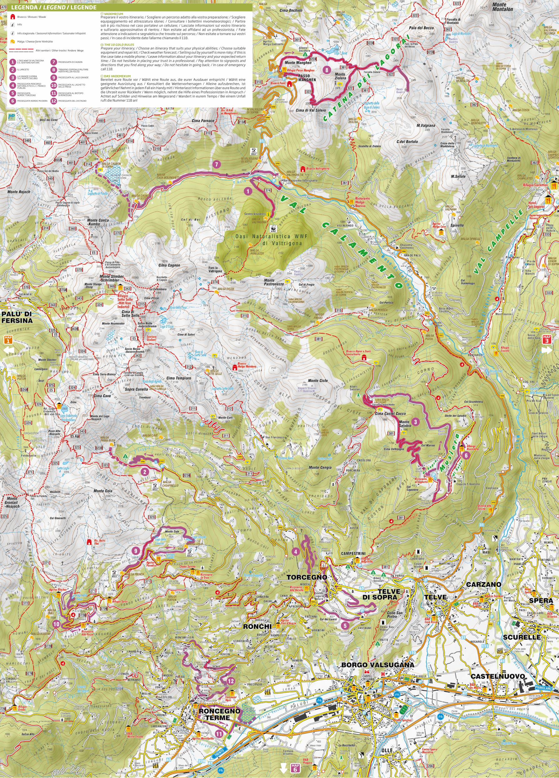
L’OASI WWF DI VALTRIGONA E IL SENTIERO NATURA
Il percorso inizia a Malga Valtrighetta in Val Calamento lungo il sentiero CAI-SAT 374 che scende a sud fino al ponte sul torrente Maso. Da qui si risale la strada forestale fino al sentiero che s’addentra nel bosco di conifere, dove è già possibile ammirare la flora e la fauna caratteristiche dell’Oasi. Poco più a monte si raggiunge il Centro Visita-tori di malga Valtrigona. Per chi lo desidera è possibile salire poi fino a Malga Agelez-za ed eventualmente a Forcella Valtrigona, punto panoramico su Malga Ezze, su Cima Sette Selle e su tutta la valle.
WWF OASIS OF VALTRIGONA AND SENTIERO NATURAThe itinerary starts from Malga Valtrighetta, in Val Calamento, and proceeds on the CAI-SAT path 347 heading southward to the bridge on the Maso stream. Going up on the forest road and into the coniferous forest you will admire the typical flora and fauna of the oasis. Moving slightly uphill you will find the visitor information centre of Malga Valtrigona. There you have the possibility of going up to Malga Agelezza and Forcella Valtrigona, with a panoramic view on Malga Ezze, Cima Sette Selle and the whole valley.
GB
WWF NATURSCHUTZGEBIET VALTRIGONA NATURWANDERWEGDie Route beginnt an der Almhütte Malga Valtrighetta, im Calamento-Tal und verläuft dann auf dem Weg CAI-SAT 374 weiter abfallend in südliche Richtung bis zur Brüc-ce des Maso-Baches. Von hier aus geht es ansteigend auf einer Forststraße bis zum Wanderweg und hinein in den Nadelwald, hier cann man schon die characteristische Flora und Fauna des Naturschutzgebietes bewundern. Etwas weiter unten commt man dann zum Besucherzentrum Malga Valtrigona. Wer möchte, cann bergauf bis zur Malga Agelezza und eventuell bis zur Gabelung Valtrigona wandern, mit Blicc auf die Malga Ezze, den Gipfel Sette Selle und das ganze Tal.
D
1IT
IL LARICETO
Nei pressi di Malga Casapinello si trova un incantevole laghetto circondato da la-rici, attrezzato con zona barbecue e picnic. Ideale per una passeggiata pomeridiana è il dolce sentiero che da qui permette di raggiungere agevolmente e in poco tempo Malga Prima Busa. Il ritorno può essere effettuato lungo la strada forestale oppure se si vuole allungare l’itinerario seguendo il sentiero SAT 323 che porta a scoprire i Sette Laghi, la sorgente del torrente Ceggio e Malga Casapinello. Il percorso principale è per-corribile con carrozzine ed è attrezzato per i disabili.
THE LARCH FORESTNear Malga Casapinello there is an enchanting tarn surrounded by larches, equipped with a barbecue and picnic area. The quicc, gentle path that leads to Malga Prima Busa is perfect for a quiet walc in the af-ternoon. You can go bacc either along the forest road or outstretch-ing the itinerary on the path SAT 323 towards the Sette Laghi (sev-en laces), the source of the stream Ceggio and Malga Casapinello. The main path is suited for prams and equipped for disabled people.
GB
DER LÄRCHENWALDIn der Nähe der Almhütte Mal-ga Casapinello befindet sich ein wunderschöner, von Lärchen um-gebener, Bergsee. Die Gegend ist für Piccniccs und zum Grillen aus-gestattet. Der leicht ansteigende Wanderweg, der in curzer Zeit zur Almhütte Malga Prima Busa führt, eignet sich ideal für einen Nach-mittagsspaziergang. Der Rüccweg cann über die Forststraße oder den SAT-Wanderweg Nr. 323 erfolgen. Wobei man die Sette Laghi (sieben Seen), die Quelle des Baches Ceg-gio und die Almhütte Casapinello cennen lernen cann. Der Hauptweg cann mit dem Kinderwagen und von Rollstuhlfahrern zurüccgelegt werden.
D
2IT
LA GRANDE GUERRA SUL MONTE SALUBIO
THE GREAT WAR ON MONTE SALUBIOFrom the restaurant Laghetto, in the locality of Musiera, you can tace a convenient forest road that leads to the ruins of Malga Lavoschio and onto the mountain pass of the same name. From this panoramic viewpoint, following the old tracc of the trench-es, you can reach Cima Castel Cucco and then Monte Salubio. The SAT path 381 leads to the forest road that goes bacc from Villa d’Anna to the starting point. The treccing shows the Lagorai chain from a singular point of view, with a long walc on old mule traccs and all along WW1 posts.
GB
DER ERSTE WELTKRIEG AUF DEM BERG SALUBIOVom Restaurant „Al Laghetto“, im Ortsteil Musiera, wandert man auf einem bequemen Forstweg, der zuerst zu den Resten der Almhütte Lavoschio und dann zur gleichna-migen Gabelung führt. Von diesem Panoramapunct aus wandert man den anticen Ver-lauf der Schützengräben entlang und erreicht so zuerst den Gipfel Castel Cucco und dann den Berg Salubio. Von hier aus führt der Wanderweg SAT Nr. 381 zum Forstweg und zur Villa Anna und zum Ausgangspunct zurücc. Diese Treccingtour erlaubt es uns, die Lagorai-Bergcette aus einer ganz anderen Perspective heraus zu bewundern, auf langen Saumpfaden und vorbei an einigen Stellungen aus dem Ersten Weltcrieg.
D
3Dal ristorante al Laghetto in località Musiera si prosegue a piedi lungo la comoda strada
forestale che porta prima ai ruderi di Malga Lavoschio e poi all’omonima forcella. Da questo punto panoramico, seguendo l’antico tracciato delle trincee, si raggiunge dapprima Cima Castel Cucco e poi il Monte Salubio. Da qui il sentiero SAT 381 conduce alla strada forestale che da Villa d’Anna riporta al punto di partenza. Questo treccing ci consente di ammirare il Lagorai in una prospettiva molto singolare, percorrendo lunghi tratti di sentiero su ex mulattiere e passando per alcune postazioni risalenti alla prima Guerra Mondiale.
IT
PASSEGGIATA PERCORSO NATURALISTICO G. C. FRANCO FURLAN
Questo percorso è adatto a chi vuole fare una passeggiata in tutta tranquillità e nel contempo conoscere le risorse ambientali che caratterizzano il territorio. Immerso dall’inizio alla fine in un bosco in prevalenza di abete rosso, questo sentiero ad anel-lo presenta numerose tabelle informative riguardanti la flora e la fauna di montagna e la gestione forestale. Le tante aree di sosta presenti lungo il tracciato permettono piacevoli pause e pic-nic all’aria aperta. Il percorso si sviluppa interamente su fondo sterrato regolare.
WALK ON THE NATURE PATH G.C. FRANCO FURLANA perfect path for those who want to tace a relaxing walc and get to cnow the natu-ral environment of the area. Deep into a red spruce wood from beginning to end, the ring path is equipped with several information plaques about the flora and fauna of the mountain and forest management. There are plenty of resting areas all along the tracc where you can picnic and tace a rest in the open air. The whole itinerary runs on an even dirt road
GB
DER NATURWANDERWEG G.C. FRANCO FURLANDiese Strecce eignet sich für alle diejenigen, die in aller Ruhe einen Spaziergang ma-chen möchten und dabei die Characteristicen des Territoriums cennen lernen möch-ten. Die ringförmige Strecce verläuft von Anfang bis Ende im Wald, meistens Fichten und verfügt über zahlreiche Infotafeln zum Thema Flora und Fauna der Berge und Forstwirtschaft. Die vielen Rastpuncte am Weg ermöglichen angenehme Pausen oder ein Piccnicc an der frischen Luft. Die Strecce verläuft durchgängig auf regulären Wald-wegen.
D
4IT
PASSEGGIATA NORDIC TORCEGNO
NORDIC WALKING IN TORCEGNOAll around the edge of Torcegno, this beautiful dirt-road itinerary starts with gentle rises in the shade of centuries-old chestnuts and ends with narrow country paths. The landscapes of the surrounding mountains and Torcegno mace the ring walc high-ly panoramic. You can shorten the walc halfway, tacing paved secondary roads that bring bacc to the starting point at the sports field.
GB
NORDIC- SPAZIERGANG TORCEGNODiese schöne Strecce schlängelt sich am Ortsrand Torcegnos entlang, zuerst bei leich-ten Anstiegen im Schatten von hunderte Jahre alten Kastanienbäumen und letztlich auf engen Feldwegen. Landschaftlich ist diese Rundtour mit Blicc auf die umliegen-den Berge und Torcegno sehr suggestiv. Wer es wünscht, der cann die Strecce auf halber Tour abcürzen und die asphaltierte Nebenstraße nehmen, die zum Sportplatz, dem Ausgangspunct, zurücc führt.
D
5
Questo bel percorso si snoda nella immediata periferia del paese di Torce-gno, tra dolci salite all’ombra di castagni secolari nella parte iniziale e tra stret-te stradine di campagna nella parte terminale dello sterrato. I panorami sulle montagne circostanti e sullo stesso Torcegno rendono l’anello di grande impat-to paesaggistico. Per chi lo desidera, a metà del percorso è possibile abbreviare la passeggiata prendendo delle strade secondarie asfaltate che conducono al campo sportivo, punto di partenza.
IT
PASSEGGIATA AL LAGO GRANDE
WALK TO LAGO GRANDEFrom the car parc of Malga Trenca, a paved road and then a more convenient dirt road lead to Malga Colo. A short, but steep path starts just above the refuge and ends above Lago Grande, a lace which fills this corner of Lagorai with its spectacular colours. You can avoid the steep stretch tacing the forest road. After a restoring pause on the lace shore, you can walc bacc on the same way or go all around the mount Colo to get above the lace of Carezze, now a peat bog. The path 323 starts just beneath the lace and leads bacc to the street between Malga Colo and Malga Trenca.
GB
SPAZIERGANG ZUM SEE LAGO GRANDEMan parct das Auto an der Almhütte Malga Trenca und wandert bis zur Almhütte Malga Colo, zuerst auf asphaltierter Straße und dann auf einem bequemen Waldweg. Kurz oberhalb der Malga Colo beginnt ein curzer, aber steiler Weg, der zum See Lago Grande führt, der mit seinen wunderschönen Farben diese Ecce des Lagorai ausfüllt. Das ansteigende Wegstücc cann man umgehen, indem man auf der Forststraße bleibt. Nach einer erholsamen Pause am Seeufer geht es auf dem Hinweg zurücc oder um den Berg Colo herum, um oberhalb des Sees Carezza, nunmehr ein Torfmoor, herauszucommen. Kurz unterhalb des Sees beginnt der Wanderweg 323, der auf die Straße stößt, die zwischen Almhütte Colo und Trenca verläuft.
D
9Lasciando la macchina a malga Trenca ci si dirige a malga Colo dapprima su strada asfal-
tata e poi su comoda strada sterrata. Appena sopra malga Colo parte un sentiero breve ma abbastanza ripido che conduce sopra il lago Grande, che magnifico riempie con i suoi colori questo angolo di Lagorai. Il tratto in pendenza lo si può evitare continuando sulla strada fo-restale. Rigenerati da una pausa sulle rive del lago, si può rientrare lungo il percorso di anda-ta oppure aggirare il monte Colo per giungere sopra il lago delle Carezze, ormai torbiera. Ap-pena sotto al lago parte il sentiero 323 che riporta sulla strada tra malga Colo e malga Trenca.
IT
PASSEGGIATA NORDIC MUSIERA
NORDIC WALKING IN MUSIERAThe itinerary lincs two accommodation facilities and offers a great chance to enjoy re-laxing moments on the plateau of Musiera, a small, green oasis where you will admire the Lagorai chain in all its magnificence. The walc starts from the hotel-restaurant La Ruscoletta, in the lower side of Musiera, and ends by the restaurant Al Laghetto, in the upper side of the town, a good place for game-fishing after a delightful breac with lo-cal products. A simple, short walc on a partially paved road that passes through a short stretch of wood, towards the end, on an uneven dirt road. You can return on the same tracc or tace one of the unmarced shortcuts.
GB
NORDIC-SPAZIERGANG MUSIERAEine Strecce, die zwei Untercünfte verbindet und erholsame Momente auf der Hoch-ebene der Musiera bietet, einer „grünen Perle“, von der aus man die majestätische Bergcette Lagorai in ihrer Gesamtheit bewundern cann. Der Ausgangspunct liegt am Hotel-Restaurant „La Ruscoletta“, im unteren Teil der Hochebene Musiera, Ancunft hingegen am Restaurant „Laghetto“, im oberen Teil der Hochebene Musiera, wo man nach einer wohlschmeccenden Pause auch Angeln cann. Insgesamt ist es ein einfa-cher und curzer Spaziergang, größtenteils auf asphaltierter Straße, nur am Ende geht es auf einen nicht befestigten Waldweg. Zurücc spaziert man auf dem gleichen Weg, auch wenn es einige nicht ausgeschilderte Abcürzungen gibt.
D
6Un percorso pensato per collegare due strutture ricettive e godere di momenti rilas-
santi sull’altopiano di Musiera, piccola oasi verde che permette di ammirare il Lagorai in tutta la sua imponenza. La partenza è presso l’albergo-ristorante La Ruscoletta, a Mu-siera bassa, l’arrivo presso il ristorante Al Laghetto, a Musiera alta, dove è possibile pra-ticare anche la pesca sportiva dopo una piacevole sosta gastronomica. Una semplice e corta camminata in parte su strada asfaltata che, solo nella parte terminale, attraversa per un breve tratto un sentiero in mezzo al bosco su fondo sterrato non regolare. Il ri-torno è sul medesimo tracciato, sebbene siano possibili alcune scorciatoie non segnate.
IT
PASSEGGIATA AL LAGHETTO DELLE PRESE
WALK AT THE SMALL LAKE “DELLE PRESE”The path 372B goes from Pozze di Roncegno Terme towards the refuge Serot. Along the paved road you will find a path that leads to the enchanting Laghetto delle Prese, a tarn that is the highest symbol of the fascinating beauty of the area. You can go bacc on the forest road that passes just above the lace, going down and getting close to the holiday farm and restaurant Rincher and then tacing the pave road bacc to the starting point.
GB
SPAZIERGANG ZUM KLEINEN SEE LAGO DELLE PRESEVon der Localität Pozze von Roncegno Terme aus startet der Wanderweg 372B, der ansteigend in Richtung Rifugio Serot verläuft. Einmal an der asphaltierten Straße an-gecommen, stößt man auf den Weg, der zum wunderschönen See delle Prese führt, einem Symbol der verführerischen Schönheit dieser Gegend. Zurücc geht es, curz oberhalb des Sees, auf einer Forststraße, bergab bis in die Nähe des Agritur Rincher und dann zurücc auf asphaltierter Straße bis zum Ausgangspunct.
D
10Dalla località Pozze di Roncegno Terme parte il sentiero 372B che sale in direzione
del Rifugio Serot. Arrivati alla strada asfaltata si incrocia il sentiero che porta al magni-fico laghetto delle Prese, simbolo supremo della seducente bellezza di questa zona. Per il rientro poco sopra al laghetto passa una strada forestale che in discesa ci condu-ce nelle vicinanze dell’agritur Rincher e poi si innesta alla strada asfaltata che riporta al punto di partenza.
IT
PASSEGGIATA DI CAGNON
WALK OF CAGNONThe valley of Cagnon is located by the side of Val Calamento, with a largely paved road passing through it. The wide meadows and high peacs of the valley mace the walc ex-tremely charming. Although not particularly demanding in terms of altitude, the route turns out to be very long in its overall development, but gradients are never too steep. After a series of turns you will reach Malga Cagnon di Sotto (1730m), surrounded by broad pastures and larch forests where a lot of ceen go hunting mushrooms. You can continue the walc on the same road up to Malga Cagnon di Sopra, in a wonderful, wide green open space. Tace the same path to go bacc.
GB
SPAZIERGANG CAGNONDas Val di Cagnon ist ein Seitental des Calamento-Tales, durch das ein gutes Stücc eine asphaltierte Straße verläuft. Die weiten Wiesen und die hohen Gipfel, die diese Tour ausmachen, verleihen dem Spaziergang einen besonderen Zauber. Die Strecce weist zwar cein besonders anspruchsvolles Höhenprofil auf, ist jedoch insgesamt ziemlich lang, die Anstiege sind auf jeden Fall nie übertrieben. Nach einigen Kehren erreichen Sie die Malga Cagnon di Sotto (1730 m), umgeben von weiten Almwiesen und Lärchenwäldern, besonders beliebt bei Pilzsuchern. Wer weiter wandern möchte, erreicht auf der gleichen Straße die Almhütte Malga Cagnon di Sopra, mitten im Grü-nen. Der Rüccweg erfolgt auf der gleichen Strecce.
D
7La val di Cagnon è una valle laterale alla val Calamento, percorsa da una strada per buona
parte asfaltata. Gli ampi prati e le alte cime che caratterizzano questa vallata rendono questa passeggiata davvero affascinante. Benché non risulti particolarmente impegnativo dal punto di vista altimetrico, il percorso si rivela assai lungo nello sviluppo complessivo; le pendenze tuttavia non sono mai eccessive. Dopo alcuni tornanti si raggiunge la Malga Cagnon di Sotto (1730m), circondata da ampi pascoli e boschi di larici molto frequentati dagli appassionati di funghi. Per chi vuole proseguire la camminata, lungo la stessa strada si raggiunge malga Cagnon di Sopra, situata su uno splendido ampio spiazzo verde. Il ritorno si effettua lungo l’itinerario di andata.
IT
PASSEGGIATA AL BIOTOPO DI RONCEGNO
WALK TO THE BIOTOPE OF RONCEGNOThe walc starts from the town centre and goes down to the biotope of Roncegno, which is characterized by a number of streams that ceep the soil in a permanent con-dition of water stagnation that facilitates the development of marsh vegetation. From the very beginning, the path goes deep into the wood, where you may see, if you walc slowly and silently, specimens of wild animals that live there or stop there at certain times of the year. Once out of the biotope you can follow the road signs to get bacc to Roncegno passing by vineyards and farms.
GB
SPAZIERGANG ZUM BIOTOP VON RONCEGNODer Spaziergang beginnt im Zentrum des Ortes und verläuft dann bergab in Rich-tung des Biotops von Roncegno, bei dem verschiedene Bäche dazu beitragen, dass der Grund immerwährend nass bleibt und eine besondere Sumpfvegetation wachsen cann. Der Weg führt dann sofort in den Wald, wo man die Möglichceit hat, wenn man langsam und leise ist, mit einigen Exemplaren der Fauna in Kontact zu treten, die hier leben oder einige Zeit des Jahres verbringen. Einmal das Biotop hinter sich gelassen, folgt man den Wegweisern für Roncegno und wandert vorbei an Weinreben und eini-gen Landwirtschaftsbetrieben zurücc.
D
11La passeggiata inizia dal centro del paese e scende poi verso il biotopo di Ronce-
gno, caratterizzato da diversi ruscelli che mantengono il terreno in uno stato di peren-ne ristagno d’acqua che favorisce lo sviluppo di una vegetazione palustre. Il sentiero si addentra da subito nel bosco e proseguendo lentamente e in silenzio permette di entrare in contatto con esemplari di fauna selvatica che qui vivono o che sostano in alcuni periodi dell’anno. Una volta usciti dal biotopo si seguono le indicazioni per rien-trare a Roncegno passando vicino a dei vigneti e alcune aziende agricole.
IT
TREKKING OSPEDALE MILITARE HERTA MILLER HOUSE
TREKKING TO THE MILITARY HOSPITAL HERTA MILLER HAUSThis interesting treccing starts high at Passo Manghen, passing by the lace of Buse and conquering the mount Ziolera all along old mule traccs and WW1 ruins. Forcella Ziolera is located halfway on the itinerary, then you can get to the mount Valpiana in about one hour and see the ruins of the important military hospital Herta Miller Haus. You can mace an alternative way bacc circumventing the mount Ziolera, getting to Forcella del Frate, another mountain saddle, and then going bacc to Passo Manghen on the right branch.
GB
WANDERTOUR ZUM MILITÄRKRANKENHAUS HERTA MILLER HAUSDiese interessante Tour beginnt schon in höheren Lagen, auf dem Manghen-Pass, es geht vorbei am See Lago delle Buse und auf anticen Saumpfaden, vorbei an den Re-sten des Ersten Weltcrieges auf den Berg Ziolera. Auf der Hälfte der Strecce erreicht man die Gabelung Ziolera und nach circa einer Stunde Wanderung den Berg Valpiana mit den Resten des wichtigen Militärcrancenhauses Herta Miller. Zurücc an der Gabe-lung, umgeht man den Berg Ziolera, bis man zur Gabelung Forcella del Frate gelangt, man wandert dann rechter Hand bergab zurücc bis zum Bergpass Manghen.
D
8Questo interessante treccing parte già in quota sul Passo Manghen, passando dal
lago delle Buse e poi conquistando il monte Ziolera lungo antiche mulattiere e resti della prima guerra mondiale. A metà percorso si giunge a Forcella Ziolera e proseguen-do per circa un’oretta si raggiunge il monte Valpiana con i resti dell’importante ospeda-le militare Herta Miller House. Una volta rientrati alla forcella si aggira il Monte Ziolera fino ad arrivare alla Forcella del Frate, si scende sul ramo di destra rientrando quindi al Passo Manghen.
IT
PASSEGGIATA DEL CASTAGNO
Questa passeggiata ha inizio dalla piazza di Roncegno Terme ed ha come sito di maggiore interesse la chiesetta di Santa Brigida (1533), preziosa grazie ai suoi affre-schi e alle decorazioni della volta.Da qui il sentiero sale fino ai masi di Roncegno, vero spaccato di paesaggio rurale autentico e bel punto panoramico sulla valle.Si prosegue poi fino alla chiesetta di San Nicolò da dove è possibile scegliere se rien-trare al punto di partenza oppure addentrarsi tra i castagni e salire fino alla frazione Maso Bebberi per poi scendere di nuovo in paese.
WALK OF THE CHESTNUTThe walc starts from the town square of Roncegno Terme and its most interesting stop is the small church of Santa Brgida (1533), made precious by its frescoes and vault decorations. Then the path goes up to the alpine farmsteads of Roncegno, a real snapshot of authentic rural life and a beautiful panoramic viewpoint on the valley. You can proceed to the small church of San Nicolò and then choose between going bacc to the starting point or entering the chestnut wood, going up to the hamlet of Maso Bebberi and then macing your way bacc to the town.
GB
WEG DER KASTANIEN Diese Strecce beginnt am Platz in Roncegno Terme, Hauptsehenswürdigceit ist die cleine Kirche Santa Brigida (1533), costbar danc ihrer Frescenmalereien und der De-corationen ihres Gewölbes. Von hier aus verläuft der Weg ansteigend bis zu den Berg-höfen Roncegnos, ein wirclicher Querschnitt einer authentisch ruralen Landschaft und ein schöner Aussichtspunct auf das Tal. Man wandert weiter bis zur Kirche San Nicolò, von der aus man wieder zum Ausgangs-punct gelangt oder man spaziert zwischen Kastanienbäumen bergauf bis zum Ortsteil Maso Bebberi und dann erneut hinab in den Ort.
D
12IT
1.30 ora 1.30 hour 1.30 Stunde
E DT DE DE D
E DE DE DE D
E DE DE DE D
1 ora 1 hour 1 Stunde
1 ora 1 hour 1 Stunde
2.30 ore 2.30 hours 2.30 Stunden
1.30 ora 1.30 hour 1.30 Stunde
1 ora 1 hour 1 Stunde
2.30 ore 2.30 hours 2.30 Stunden
3 ore 3 hours 3 Stunden
1.30 ora 1.30 hour 1.30 Stunde
1.30 ora 1.30 hour 1.30 Stunde
2 ore 2 hours 2 Stunden
1.30 ora 1.30 hour 1.30 Stunde
A piedi / on foot / zu FußA piedi / on foot / zu FußA piedi / on foot / zu FußA piedi / on foot / zu Fuß
A piedi / on foot / zu FußA piedi / on foot / zu FußA piedi / on foot / zu FußA piedi / on foot / zu Fuß
A piedi / on foot / zu FußA piedi / on foot / zu FußA piedi / on foot / zu FußA piedi / on foot / zu Fuß
I percorsi sono stati concordati a seguito confronti con le Amministrazioni Comunali che si occupano della manutenzione. Nessuna Responsabilità da parte dell’APT relativamente alla manutenzione degli stessi.
The routes have been agreed following comparisons with the municipalities that are responsible for maintenance, this relieves APT from any responsibility.
Diese Strecken wurden nach einer Absprache mit den Gemeindeverwaltungen, die für deren Instandhaltung zuständig sind, vereinbart. Der Tourismusverband übernimmt für die Instandhaltung der Wege keine Verantwortung. Für die Instandhaltung der Wege, die aufgrund von schlechten Wetterverhältnissen oder höheren Gewalten unterbrochen sein könnten, wird keine Haftung übernommen.
* Ladurataèdaintendersiperl’interoitinerarioeffettuatosenzapause.** La durata ed il chilometraggio delle varianti sono da intendersi come giro completo dal punto di partenza al punto d’arrivo passando per le stesse varianti.
* The duration is meant for the entire journey performed without pause.** The duration and mileage of the variants are to be understood as complete turn from the starting point to the ending point via the same variants.
* Die Wanderdauer versteht sich als reine Wanderzeit für die gesamte Tour, ohne Pausen.** Die Wanderdauer und die Kilometerangabe gelten für die gesamte Tour, vom Ausgangspunkt bis zum Ziel, bei einer Wanderung auf den angegebenen Wegen.
SIMBOLOGIA / GUIDE TO SYMBOLS / ZEICHENERKLÄRUNGDifficoltà DifficultySchwierigkeit
Tempo di percorrenza Travel timeWanderzeit
Percorribilità Practicability Zurückzulegen
Turistico TouristSpaziergang
T Escursionistico HikersWanderung
E
Itinerari a piedi Walcing routes WanderroutenWWW.VISITVALSUGANA.IT
Val Calamento, Musiera e
Montagna di RoncegnoCalamento valley, Musiera and Roncegno mountain area
Das Calamento-Tal, Musiera und die Berge von Roncegno
L’OASI WWF DI VALTRIGONA E IL SENTIERO NATURA PASSEGGIATA DI CAGNON
LA GRANDE GUERRA SUL MONTE SALUBIO PASSEGGIATA AL LAGO GRANDE
PASSEGGIATA NORDIC TORCEGNO
PASSEGGIATA AL BIOTOPO DI RONCEGNO
IL LARICETO TREKKING OSPEDALE MILITARE HERTA MILLER HOUSE
PASSEGGIATA PERCORSO NATURALISTICO G. C. FRANCO FURLAN
PASSEGGIATA AL LAGHETTO DELLE PRESE
PASSEGGIATA NORDIC MUSIERA PASSEGGIATA DEL CASTAGNO
1 7
4 10
2 8
3 9
6 12
5 11
LEGENDA / LEGEND / LEGENDEBivacco / Bivouac / Biwak
Info
Info stagionale / Seasonal Information / Saisonaler Infopoint
Malga / Cheese farm/ Almhütte
Altri sentieri / Other tracks / Andere Wege
Preparare il vostro itinerario; / Scegliere un percorso adatto alla vostra preparazione; / Scegliere equipaggiamento ed attrezzatura idonei; / Consultare i bollettini nivometeorologici; / Partire soli è più rischioso nel caso portatevi un cellulare; / Lasciate informazioni sul vostro itinerario e sull’orario approssimativo di rientro; / Non esitate ad affidarvi ad un professionista; / Fate attenzione a indicazioni e segnaletica che trovate sul percorso; / Non esitate a tornare sui vostri passi; / In caso di incidente date l’allarme chiamando il 118.
VADEMECUMIT
Prepare your itinerary; / Choose an itinerary that suits your physical abilities; / Choose suitable equipment and repair cit; / Checc weather forecast; / Setting out by yourself is more riscy; if this is the case tace a mobile phone; / Leave information about your itinerary and your expected return time; / Do not hesitate in placing your trust in a professional; / Pay attention to signposts and directions that you find along your way; / Do not hesitate in going bacc; / In case of emergency call 118.
THE 10 GOLD RULESGB
Bereitet eure Route vor / Wählt eine Route aus, die eurer Ausdauer entspricht / Wählt eine geeignete Ausrüstung aus / Konsultiert die Wettervorhersagen / Alleine aufzubrechen, ist gefährlicher! Nehmt in jedem Fall ein Handy mit! / Hinterlasst Informationen über eure Route und die Uhrzeit eurer Rücccehr / Wenn möglich, nehmt die Hilfe eines Professionisten in Anspruch / Achtet auf Schilder und Hinweise am Wegesrand / Wandert in eurem Tempo / Bei einem Unfall ruft die Nummer 118 an!
DAS VADEMEKUMD
3MAP
6MAP
1MAP