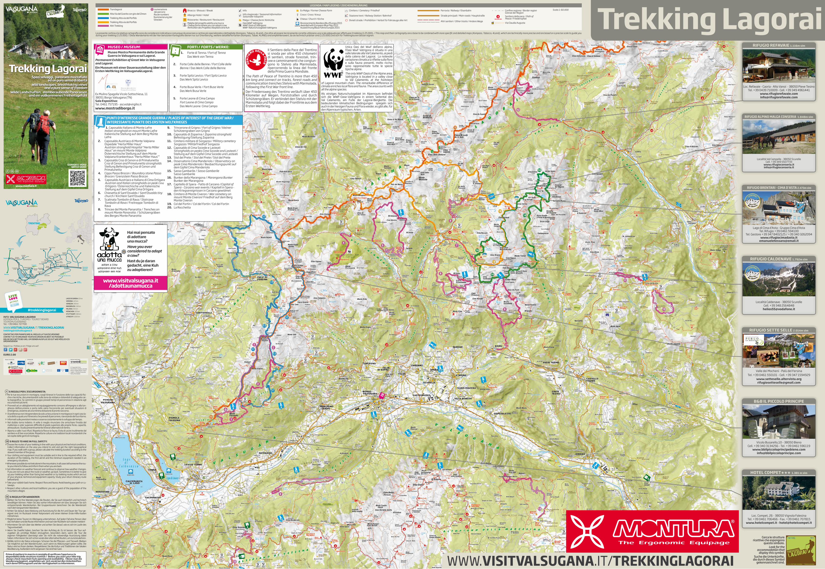
Cartina trekking 2016 montura web
2
6 REGOLE PER L’ESCURSIONISTA: > Per le tue escursioni in montagna, scegli itinerari in funzione delle tue capacità fisi - che e tecniche, documentandoti sulla zona da visitare e dotandoti di adeguata car- ta topografica. Se cammini in gruppo prevedi tempi di percorrenza in relazione agli escursionisti più lenti. > Provvedi ad un abbigliamento ed equipaggiamento consono all’impegno e alla lun- ghezza dell’escursione e porta nello zaino l’occorrente per eventuali situazioni di emergenza, assieme ad una minima dotazione di pronto soccorso. > Di preferenza non intraprendere da solo un’escursione in montagna e in ogni caso la- scia detto a qualcuno l’itinerario che prevedi di percorrere, riavvisando del tuo ritorno. > Informati sulle previsioni meteo e osserva costantemente lo sviluppo del tempo. > Nel dubbio torna indietro. A volte è meglio rinunciare che arrischiare l’insidia del maltempo o voler superare difficoltà di grado superiore alle proprie forze, capacità, attrezzature. Studia preventivamente itinerari alternativi di rientro. > Riporta a valle i tuoi rifiuti. Rispetta la flora e la fauna. Evita di uscire inutilmente dal sentiero e di fare scorciatoie. Rispetta le culture e le tradizioni locali ricordandoti che sei ospite delle genti di montagna. IT 6 RULES TO HIKE IN FULL SAFETY: > Choose the routes of your trekking in line with your physical and technical conditions. Collect information on the area you intend to visit and get the right topographical map. If you walk with a group, please calculate the trekking duration according to the slowest member of the group. > Your clothing and equipment must be suitable and in line to the required effort, the duration of the trekking, the first aid kit and the minimum equipment needed in an emergency situations. >Whenever possible do not trek alone in the mountains. In all cases tell someone the rou- te you intend to follow and inform them when you are back. > Get information on weather forecast and continue to observe how weather changes. If you are not sure about the route or weather, go back. Sometimes it is better to give up your trekking rather than facing bad weather or try trekking routes which are out of your physical, technical and equipment capacity. Study your return itinerary route beforehand. > Take your rubbish back home. Respect flora and fauna. Avoid leaving your path or cu- taways. > Respect other cultures and local traditions: you are a guest of the population of the mountains villages GB 6 REGELN FÜR WANDERER: > Wählen Sie für Ihre Wanderungen die Routen, die Sie auch körperlich und technisch bewältigen können. Holen Sie also vorher Informationen ein bzw. besorgen Sie sich entsprechende Wanderkarten. Bei Gruppentouren berechnen Sie die Wanderzeit nach dem langsamsten Wanderer. > Achten Sie darauf, dass Kleidung und Ausrüstung für die Art und Dauer der Tour ge- eignet sind. Im Rucksack immer Notproviant und einen kleinen Erste-Hilfe-Kasten mitnehmen. > Möglichst keine Touren im Alleingang unternehmen. Auf jeden Fall eine Person über das Vorhaben und die Route informieren und nach der Rückkehr sich wieder melden! > Informieren Sie sich über das Wetter und achten Sie darauf, wie es sich im Laufe des Tags entwickelt. > Wenn Sie Zweifel haben, brechen Sie den Aufstieg ab. Es ist besser, die Tour auf- zugeben als unnötige Risiken einzugehen, besonders dann, wenn die Tour die eigenen Fähigkeiten übersteigt oder Sie nicht die notwendige Ausrüstung dabei haben. Informieren Sie sich schon vorab über alternative Routen, um zurückzukehren. > Abfälle nicht in der Natur entsorgen. Schonen Sie die Pflanzen- und Tierwelt. Bleiben Sie möglichst auf den Wanderrouten, auch wenn es Abkürzungen geben sollte. Die Natur wird es Ihnen danken. Respektieren Sie die Kultur und Traditionen der lokalen Bevölkerung. Außerdem nicht vergessen: Sie sind hier Gast. DE Trekking Lagorai LEGENDA / MAP LEGEND / ZEICHENERKLÄRUNG La presente cartina e la relativa cartografia sono da considerarsi indicative e comunque da associare a cartine più specializzate e dettagliate (Kompass, Tabacco, 4Land), che oltre ad essere tecnicamente corrette utilizzano una scala adeguata per effettuare il trekking (1:25.000). / This map and their cartography are a base to be combined with more specific and detailed maps (Kompass, Tabacco, 4Land), which are technically more precise and are based on a precise scale to guide you during your trekking (1:25.000). / Diese Wanderkarte mit der hier benutzten Kartografie dienen nur zur Orientierung, weitere detaillierte Karten (Kompass, Tabak, 4LAND) sind empfehlenswert, da sie technisch präziser sind (1:25.000) und sich für Trekkingtouren besser eignen. Translagorai Alta Via del Granito con giro del Zimon Trekking Alta via del Porfido Bivacco / Bivouac / Biwak Albergo Hotel / Hotel Ristorante / Restaurant / Restaurant Info Info stagionale / Seasonal Information Saisonaler Infopoint Malga / Cheese farm/ Almhütte Ex Malga / Former Cheese Farm Croce / Cross / Kreuz Chiesa / Church / Kirche Cimitero / Cemetery / Friedhof Stazione treni / Railway Station / Bahnhof Divieti strade / Prohibition / Verbot für Fahrzeuge aller Art Confine regione / Border region Grenze der Region Ferrovia / Railway / Eisenbahn Strade principali / Main roads / Hauptstraße Sentiero della pace / Path of Peace / Friedenspfad Via Claudia Augusta Malghe del progetto adotta una mucca Cheese farms where you can adopt a cow Almhütten des Projektes Adoptiere eine Kuh Oasi WWF Valtrigona WWF Oasis of Valtrigona WWF-Naturschutzgebiet Valtrigona Riconoscimento Bandiera Blu d’Europa 2015 Awarded with European Blue Flag 2015 Auszeichnung Blaue Fahne Europas 2015 Scala 1: 60.000 Altri sentieri / Other tracks / Andere Wege CONTATTACI PER PIANIFICARE AL MEGLIO LA TUA ESCURSIONE! CONTACT US TO ORGANIZE YOUR EXCURSION AS BEST AS POSSIBLE! MELDE DICH BITTE BEI UNS, UM DEINEN AUSFLUG SO GUT WIE MÖGLICH ZU ORGANISIEREN! WWW. VISITVALSUGANA.IT/TREKKINGLAGORAI INFO: VALSUGANA LAGORAI AZIENDA PER IL TURISMO / TOURIST BOARD TOURISMUSVERBAND Tel. +39 0461 727700 EURO 2.00 [email protected] Seguici su / Follow us on / Folge uns auf: #livelovevalsugana LAGO DI GARDA: 60 km VERONA: 120 km VENEZIA: 140 km INNSBRUCK: 190 km MILANO: 250 km MÜNCHEN: 320 km STUTTGART: 480 km UTRECHT: 1000 km #trekkinglagorai © Copyright foto: Foto di Story Travelers, Daniele Mosna, Angela Ventin, Franco Voglino - Annalisa Porporato, Marisa Montibeller MEDIA PARTNER MAIN SPONSOR SPONSOR Cerca le strutture ricettive che espongono questo simbolo. Look for the accommodation that display this symbol. Suche die Unterkünfte, die durch dieses Symbol gekennzeichnet sind. Trekking Alta via del Porfido Altri Trekking numerazione dei percorsi Route numbers Nummerierung der Strecken Bolzano Pergine Valsugana Trento Verona S. Orsola Terme Valle dei Mocheni Val di Sella S. Cristoforo al lago Calceranica al lago Altopiano della Vigolana Caldonazzo Tenna Panarotta Vetriolo Terme Levico Terme Novaledo Roncegno Terme Ronchi Torcegno Borgo Valsugana Olle Castelnuovo Telve di Sopra Spera Samone Telve Pieve Tesino Bieno Carzano Scurelle Cinte Tesino Strigno Castello Tesino Ivano Fracena Ospedaletto Villa Bassano Venezia Padova Enego Primolano Asiago Passo 5 Croci Passo Manghen Altopiano di Vezzena Altopiano della Marcesina Grigno Passo Brocon Vignola Falesina Valsugana TRENTINO Il Sentiero della Pace del Trentino si snoda per oltre 450 chilometri di sentieri, strade forestali, trin- cee e camminamenti che congiun- gono lo Stelvio alla Marmolada, ripercorrendo la linea del fronte della Prima Guerra Mondiale. The Path of Peace of Trentino is more than 450 km long and connect on tracks, forest roads and communication trenches Stelvio with Marmolada, following the First War front line. Der Friedensweg des Trentino verläuft über 450 Kilometer auf Wegen, Forststraßen und durch Schützengräben. Er verbindet den Stelvio mit der Marmolada und folgt dabei der Frontlinie aus dem Ersten Weltkrieg. S E N T I E R O D E L L A P A C E Prima di mettersi in marcia si consiglia di verificare l’apertura e la disponibilità delle strutture ricettive / Before you start your hike trip, always check mountain huts opening and availability. / Bevor man die Wanderung beginnt, empfehlen wir, sich vorab bei den Unterkünften nach deren Öffnungszeit und der Verfügbarkeit zu informieren. WWW. VISITVALSUGANA.IT/TREKKINGLAGORAI GUARDA IL VIDEO WATCH VIDEO IT DE GB MUSEO / MUSEUM: Museo Mostra Permanente della Grande Guerra in Valsugana e sul Lagorai. Permanent Exhibition of Great War in Valsugana and Lagorai. Ein Museum mit einer Dauerausstellung über den Ersten Weltkrieg im Valsugana&Lagorai. Ex Mulino Spagolla Vicolo Sottochiesa, 11 38051 Borgo Valsugana (TN) Sala Espositiva: Tel. 0461 757195 - [email protected] www.mostradiborgo.it FORTI / FORTS / WERKE: 1. Forte di Tenna / Fort of Tenna Das Werk von Tenna 2. Forte Colle delle Benne / Fort Colle delle Benne / Das Werk Colle delle Benne 3. Forte Spitz Levico / Fort Spitz Levico Das Werk Spitz Levico 4. Forte Busa Verle / Fort Busa Verle Das Werk Busa Verle 5. Forte Leone di Cima Campo Fort Leone di Cima Campo Das Werk Leone Cima Campo Unica Oasi del Wwf dell’arco alpino, l’Oasi Wwf Vatrigona è situata in una valle laterale alla Val Calamento, ai piedi della catena del Lagorai. La notevole variazione climatica si riflette sulla flora e sulla fauna presenti, molto ricche; sono rappresentate tutte le specie tipiche alpine. The only WWF Oasis of the Alpine area, Valtrigona is located in a valley close to Val Calamento, at the footsteps of Lagorai mountain chain. The remarkable difference of climate enriches local flora and fauna. The area counts with all the alpine species. Als einziges Naturschutzgebiet im Alpenraum befindet sich die WWF-Oase-Valtrigona in einem Seitental des Val Calamento, am Fuße der Lagorai-Bergkette. Die bedeutenden klimatischen Bedingungen spiegeln sich auch in der hiesigen Fauna und Flora wieder, es gibt alle, für den Alpenraum typischen, Arten. www.montura.it www.montura.it RIFUGIO ALPINO MALGA CONSERIA 1.848m slm Località Val Campelle - 38050 Scurelle Cell. +39 349 5507733 www.rifugioconseria.it [email protected] Località Caldenave - 38050 Scurelle Cell. +39 348 2564848 [email protected] RIFUGIO CALDENAVE 1.792m slm Loc. Refavaie - Caoria - Alto Vanoi - 38050 Pieve Tesino Tel. +39 0439 710009 - Cell. +39 349 4961441 www.rifugiorefavaie.com [email protected] RIFUGIO REFAVAIE 1.116m slm RIFUGIO BRENTARI - CIMA D’ASTA 2.473m slm Lago di Cima d’Asta - Gruppo Cima d’Asta Tel. Rifugio +39 0461 594100 Tel. Gestore +39 347 8402125 / +39 340 3262094 www.rifugiocimadasta.it [email protected] B&B IL PICCOLO PRINCIPE Vicolo Busarello,10 - 38050 Bieno Cell. +39 340 3134256 - Tel. +39 0461 596119 www.bbilpiccoloprincipebieno.com [email protected] Loc. Compet, 26 - 38050 Vignola Falesina Tel. +39 0461 706466 - Fax. +39 0461 707815 www.hotelcompet.it - [email protected] HOTEL COMPET★★★ 1.381 m slm RIFUGIO SETTE SELLE 2.014m slm Valle dei Mocheni - Palù del Fersina Tel. +39 0461 550101 - Cell. +39 347 1594929 www.setteselle.altervista.org [email protected] PUNTI D’INTERESSE GRANDE GUERRA / PLACES OF INTEREST OF THE GREAT WAR / INTERESSANTE PUNKTE DES ERSTEN WELTKRIEGES 1. Caposaldo Italiano di Monte Lefre Italian stronghold on mount Monte Lefre Italienische Stellung auf dem Berg Monte Lefre 2. Caposaldo Austriaco di Monte Valpiana Ospedale “Herta Miller Haus” Austrian stronghold Hospital “Herta Miller Haus” on mount Monte Valpiana Österreichische Stellung auf dem Monte Valpiana Krankenhaus “Herta Miller Haus”” 3. Caposaldo Croz di Cenon e di Primalunetta Croz di Cenon and Primalunetta strongholds Stellung Befestigung Croz di Cenon und Primalunetta 4. Cippo Passo Brocon / Boundary stone Passo Brocon / Grenzstein Passo Brocon 5. Caposaldo Austriaco e Italiano di Cima Ortigara Austrian and Italian strongholds on peak Cima Ortigara / Österreichische und Italienische Stellung auf dem Gipfel Cima Ortigara 6. Chiesetta di Sant’Osvaldo / Sant’Osvaldo tiny church / Kirchlein Sant’Osvaldo 7. Scalinata Tombolin di Rava / Staircase Tombolin di Rava / Freitreppe Tombolin di Rava 8. Trincee del Monte Panarotta / Trenches on mount Monte Panarotta / Schützengräben des Berges Monte Panarotta 9. Trincerone di Grigno / Fort of Grigno / kleiner Schützengraben von Grigno 10. Caposaldo di Zoparina / Zoparina stronghold Befestigung/Stellung Zoparina 11. Cimitero militare di Sorgazza / Military cemetery Sorgazza / Militärfriedhof Sorgazza 12. Caposaldo di Cima Socede e Lasteati Strongholds on peaks Cima Socede and Lasteati / Stellung auf dem Gipfel Cima Socede und Lasteati 13. Stol del Prete / Stol del Prete / Stol del Prete 14 . Osservatorio Cima Manderiolo / Observatory on peak Cima Manderiolo / Beobachtungspunkt auf dem Gipfel Cima Manderiolo 15. Sasso Gambarile / Sasso Gambarile Sasso Gambarile 16. Bunker della Marangona / Marangona Bunker Bunker der Marangona 17. Capitello di Spera - Fatto di Carzano /Capital of Spera - Carzano war events / Kapitell in Spera - den Kriegsereignissen in Carzano gewidmet 18. Cimitero di Monte Civeron / War cemetery on mount Monte Civeron/ Friedhof auf dem Berg Monte Civeron 19. Col del Fortin / Col del Fortin / Col del Fortin 20. La Rocchetta Trekking Lagorai Spazi selvaggi, panorami mozzafiato ed un puro senso di libertà Wild landscapes, breathtaking views and a pure sense of freedom Wilde Landschaften, atemberaubende Panoramen und ein vollkommenes Freiheitsgefühl Hai mai pensato di adottare una mucca? Have you ever considered to adopt a cow? Hast du je daran gedacht, eine Kuh zu adoptieren? adopt a cow adoptiere eine kuh adopteer een koe www.visitvalsugana.it /adottaunamucca
-
Upload
apt-valsugana -
Category
Documents
-
view
221 -
download
0
description
Trekking Lagorai 2016 Montura
Transcript of Cartina trekking 2016 montura web
6 REGOLE PER L’ESCURSIONISTA:> Per le tue escursioni in montagna, scegli itinerari in funzione delle tue capacità fisi-
che e tecniche, documentandoti sulla zona da visitare e dotandoti di adeguata car-ta topografica. Se cammini in gruppo prevedi tempi di percorrenza in relazione agli escursionisti più lenti.
> Provvedi ad un abbigliamento ed equipaggiamento consono all’impegno e alla lun-ghezza dell’escursione e porta nello zaino l’occorrente per eventuali situazioni di emergenza, assieme ad una minima dotazione di pronto soccorso.
> Di preferenza non intraprendere da solo un’escursione in montagna e in ogni caso la-scia detto a qualcuno l’itinerario che prevedi di percorrere, riavvisando del tuo ritorno.
> Informati sulle previsioni meteo e osserva costantemente lo sviluppo del tempo. > Nel dubbio torna indietro. A volte è meglio rinunciare che arrischiare l’insidia del
maltempo o voler superare difficoltà di grado superiore alle proprie forze, capacità, attrezzature. Studia preventivamente itinerari alternativi di rientro.
> Riporta a valle i tuoi rifiuti. Rispetta la flora e la fauna. Evita di uscire inutilmente dal sentiero e di fare scorciatoie. Rispetta le culture e le tradizioni locali ricordandoti che sei ospite delle genti di montagna.
IT
6 RULES TO HIKE IN FULL SAFETY:> Choose the routes of your trekking in line with your physical and technical conditions.
Collect information on the area you intend to visit and get the right topographical map. If you walk with a group, please calculate the trekking duration according to the slowest member of the group.
> Your clothing and equipment must be suitable and in line to the required effort, the duration of the trekking, the first aid kit and the minimum equipment needed in an emergency situations.
> Whenever possible do not trek alone in the mountains. In all cases tell someone the rou-te you intend to follow and inform them when you are back.
> Get information on weather forecast and continue to observe how weather changes. If you are not sure about the route or weather, go back. Sometimes it is better to give up your trekking rather than facing bad weather or try trekking routes which are out of your physical, technical and equipment capacity. Study your return itinerary route beforehand.
> Take your rubbish back home. Respect flora and fauna. Avoid leaving your path or cu-taways.
> Respect other cultures and local traditions: you are a guest of the population of the mountains villages
GB
6 REGELN FÜR WANDERER:> Wählen Sie für Ihre Wanderungen die Routen, die Sie auch körperlich und technisch
bewältigen können. Holen Sie also vorher Informationen ein bzw. besorgen Sie sich entsprechende Wanderkarten. Bei Gruppentouren berechnen Sie die Wanderzeit nach dem langsamsten Wanderer.
> Achten Sie darauf, dass Kleidung und Ausrüstung für die Art und Dauer der Tour ge-eignet sind. Im Rucksack immer Notproviant und einen kleinen Erste-Hilfe-Kasten mitnehmen.
> Möglichst keine Touren im Alleingang unternehmen. Auf jeden Fall eine Person über das Vorhaben und die Route informieren und nach der Rückkehr sich wieder melden!
> Informieren Sie sich über das Wetter und achten Sie darauf, wie es sich im Laufe des Tags entwickelt.
> Wenn Sie Zweifel haben, brechen Sie den Aufstieg ab. Es ist besser, die Tour auf- zugeben als unnötige Risiken einzugehen, besonders dann, wenn die Tour die eigenen Fähigkeiten übersteigt oder Sie nicht die notwendige Ausrüstung dabei haben. Informieren Sie sich schon vorab über alternative Routen, um zurückzukehren.
> Abfälle nicht in der Natur entsorgen. Schonen Sie die Pflanzen- und Tierwelt. Bleiben Sie möglichst auf den Wanderrouten, auch wenn es Abkürzungen geben sollte. Die Natur wird es Ihnen danken. Respektieren Sie die Kultur und Traditionen der lokalen Bevölkerung. Außerdem nicht vergessen: Sie sind hier Gast.
DE
Trekking LagoraiLEGENDA / MAP LEGEND / ZEICHENERKLÄRUNG
La presente cartina e la relativa cartografia sono da considerarsi indicative e comunque da associare a cartine più specializzate e dettagliate (Kompass, Tabacco, 4Land), che oltre ad essere tecnicamente corrette utilizzano una scala adeguata per effettuare il trekking (1:25.000). / This map and their cartography are a base to be combined with more specific and detailed maps (Kompass, Tabacco, 4Land), which are technically more precise and are based on a precise scale to guide you during your trekking (1:25.000). / Diese Wanderkarte mit der hier benutzten Kartografie dienen nur zur Orientierung, weitere detaillierte Karten (Kompass, Tabak, 4LAND) sind empfehlenswert, da sie technisch präziser sind (1:25.000) und sich für Trekkingtouren besser eignen.
Translagorai
Alta Via del Granito con giro del Zimon
Trekking Alta via del Porfido
Bivacco / Bivouac / Biwak
Albergo Hotel / Hotel
Ristorante / Restaurant / Restaurant
Info
Info stagionale / Seasonal Information Saisonaler InfopointMalga / Cheese farm/ Almhütte
Ex Malga / Former Cheese Farm
Croce / Cross / Kreuz
Chiesa / Church / Kirche
Cimitero / Cemetery / Friedhof
Stazione treni / Railway Station / Bahnhof
Divieti strade / Prohibition / Verbot für Fahrzeuge aller Art
Confine regione / Border region Grenze der Region
Ferrovia / Railway / Eisenbahn
Strade principali / Main roads / Hauptstraße Sentiero della pace / Path of Peace / Friedenspfad
Via Claudia AugustaMalghe del progetto adotta una mucca Cheese farms where you can adopt a cow Almhütten des Projektes Adoptiere eine Kuh
Oasi WWF Valtrigona WWF Oasis of Valtrigona WWF-Naturschutzgebiet Valtrigona
Riconoscimento Bandiera Blu d’Europa 2015 Awarded with European Blue Flag 2015 Auszeichnung Blaue Fahne Europas 2015
Scala 1: 60.000
Altri sentieri / Other tracks / Andere Wege
CONTATTACI PER PIANIFICARE AL MEGLIO LA TUA ESCURSIONE!CONTACT US TO ORGANIZE YOUR EXCURSION AS BEST AS POSSIBLE!MELDE DICH BITTE BEI UNS, UM DEINEN AUSFLUG SO GUT WIE MÖGLICH ZU ORGANISIEREN!
WWW.VISITVALSUGANA.IT/TREKKINGLAGORAI
INFO: VALSUGANA LAGORAI AZIENDA PER IL TURISMO / TOURIST BOARD TOURISMUSVERBAND Tel. +39 0461 727700
EURO 2.00
Seguici su / Follow us on / Folge uns auf:
#livelovevalsugana
LAGO DI GARDA: 60 kmVERONA: 120 kmVENEZIA: 140 kmINNSBRUCK: 190 kmMILANO: 250 kmMÜNCHEN: 320 kmSTUTTGART: 480 kmUTRECHT: 1000 km
#trekkinglagorai
© Copyright foto: Foto di Story Travelers, Daniele Mosna, Angela Ventin, Franco Voglino - Annalisa Porporato, Marisa Montibeller
MEDIA PARTNERMAIN SPONSOR SPONSOR
Cerca le strutture ricettive che espongono
questo simbolo.Look for the
accommodation that display this symbol.
Suche die Unterkünfte, die durch dieses Symbol
gekennzeichnet sind.
Trekking Alta via del PorfidoAltri Trekking
numerazione dei percorsi Route numbers Nummerierung der Strecken
Bolzano
PergineValsuganaTrento
Verona
S. OrsolaTerme
Valle dei Mocheni
Val di Sella
S. Cristoforoal lago
Calceranicaal lago
Altopiano della Vigolana
Caldonazzo
Tenna
Panarotta
VetrioloTerme
LevicoTerme
Novaledo
RoncegnoTerme
Ronchi
Torcegno
BorgoValsugana
Olle
Castelnuovo
Telve diSopra
Spera
Samone
Telve
Pieve Tesino
Bieno
Carzano
Scurelle
CinteTesino
Strigno
CastelloTesino
IvanoFracena
OspedalettoVilla
BassanoVeneziaPadova
EnegoPrimolano
Asiago
Passo 5 CrociPasso Manghen
Altopiano di Vezzena
Altopiano della Marcesina
Grigno
Passo Brocon
Vignola Falesina
BRENNEROBOLZANO
VENEZIA
PADOVA
BASSANO
Panarotta
Lagorai
Val diSella
Lago di Caldonazzo
VERONA
MILANO
TRENTO
A22
FS
Ss47
A4
Lago di Garda
Vezzena
Lagodi Levico
VALSUGANA
Lago di Caldonazzo
ValsuganaTRENTINO
BRENNEROBOLZANO
VENEZIA
PADOVA
BASSANO
Panarotta
Lagorai
Val diSella
Lago di Caldonazzo
VERONA
MILANO
TRENTO
A22
FS
Ss47
A4
Lago di Garda
Vezzena
Lagodi Levico
ValsuganaTRENTINO
VALSUGANA
Lago di Caldonazzo
Il Sentiero della Pace del Trentino si snoda per oltre 450 chilometri di sentieri, strade forestali, trin-cee e camminamenti che congiun-gono lo Stelvio alla Marmolada, ripercorrendo la linea del fronte della Prima Guerra Mondiale.
The Path of Peace of Trentino is more than 450 km long and connect on tracks, forest roads and communication trenches Stelvio with Marmolada, following the First War front line.Der Friedensweg des Trentino verläuft über 450 Kilometer auf Wegen, Forststraßen und durch Schützengräben. Er verbindet den Stelvio mit der Marmolada und folgt dabei der Frontlinie aus dem Ersten Weltkrieg.
SEN
TIER
O DELLA PAC
E
Prima di mettersi in marcia si consiglia di verificare l’apertura e la disponibilità delle strutture ricettive / Before you start your hike trip, always check mountain huts opening and availability. / Bevor man die Wanderung beginnt, empfehlen wir, sich vorab bei den Unterkünften nach deren Öffnungszeit und der Verfügbarkeit zu informieren. WWW.VISITVALSUGANA.IT/TREKKINGLAGORAI
GUARDA IL VIDEO WATCH VIDEO
IT DEGB
MUSEO / MUSEUM:Museo Mostra Permanente della Grande Guerra in Valsugana e sul Lagorai.
Permanent Exhibition of Great War in Valsugana and Lagorai.Ein Museum mit einer Dauerausstellung über den Ersten Weltkrieg im Valsugana&Lagorai.
Ex Mulino Spagolla Vicolo Sottochiesa, 11 38051 Borgo Valsugana (TN)Sala Espositiva:Tel. 0461 757195 - [email protected] www.mostradiborgo.it
FORTI / FORTS / WERKE:1. Forte di Tenna / Fort of Tenna
Das Werk von Tenna
2. Forte Colle delle Benne / Fort Colle delle Benne / Das Werk Colle delle Benne
3. Forte Spitz Levico / Fort Spitz Levico Das Werk Spitz Levico
4. Forte Busa Verle / Fort Busa Verle Das Werk Busa Verle
5. Forte Leone di Cima Campo Fort Leone di Cima Campo Das Werk Leone Cima Campo
Unica Oasi del Wwf dell’arco alpino, l’Oasi Wwf Vatrigona è situata in una valle laterale alla Val Calamento, ai piedi della catena del Lagorai. La notevole variazione climatica si riflette sulla flora e sulla fauna presenti, molto ricche; sono rappresentate tutte le specie tipiche alpine. The only WWF Oasis of the Alpine area, Valtrigona is located in a valley close to Val Calamento, at the footsteps
of Lagorai mountain chain. The remarkable difference of climate enriches local flora and fauna. The area counts with all the alpine species.Als einziges Naturschutzgebiet im Alpenraum befindet sich die WWF-Oase-Valtrigona in einem Seitental des Val Calamento, am Fuße der Lagorai-Bergkette. Die bedeutenden klimatischen Bedingungen spiegeln sich auch in der hiesigen Fauna und Flora wieder, es gibt alle, für den Alpenraum typischen, Arten.
www.montura.it
www.montura.it
RIFUGIO ALPINO MALGA CONSERIA 1.848m slm
Località Val Campelle - 38050 Scurelle Cell. +39 349 5507733
www.rifugioconseria.it [email protected]
Località Caldenave - 38050 ScurelleCell. +39 348 2564848
RIFUGIO CALDENAVE 1.792m slm
Loc. Refavaie - Caoria - Alto Vanoi - 38050 Pieve Tesino Tel. +39 0439 710009 - Cell. +39 349 4961441
www.rifugiorefavaie.com [email protected]
RIFUGIO REFAVAIE 1.116m slm
RIFUGIO BRENTARI - CIMA D’ASTA 2.473m slm
Lago di Cima d’Asta - Gruppo Cima d’AstaTel. Rifugio +39 0461 594100
Tel. Gestore +39 347 8402125 / +39 340 3262094www.rifugiocimadasta.it
B&B IL PICCOLO PRINCIPE
Vicolo Busarello,10 - 38050 Bieno Cell. +39 340 3134256 - Tel. +39 0461 596119
www.bbilpiccoloprincipebieno.com [email protected]
Loc. Compet, 26 - 38050 Vignola FalesinaTel. +39 0461 706466 - Fax. +39 0461 707815
www.hotelcompet.it - [email protected]
HOTEL COMPET★★★ 1.381 m slm
RIFUGIO SETTE SELLE 2.014m slm
Valle dei Mocheni - Palù del FersinaTel. +39 0461 550101 - Cell. +39 347 1594929
www.setteselle.altervista.org [email protected]
PUNTI D’INTERESSE GRANDE GUERRA / PLACES OF INTEREST OF THE GREAT WAR / INTERESSANTE PUNKTE DES ERSTEN WELTKRIEGES
1. Caposaldo Italiano di Monte Lefre Italian stronghold on mount Monte Lefre Italienische Stellung auf dem Berg Monte Lefre
2. Caposaldo Austriaco di Monte Valpiana Ospedale “Herta Miller Haus” Austrian stronghold Hospital “Herta Miller Haus” on mount Monte Valpiana Österreichische Stellung auf dem Monte Valpiana Krankenhaus “Herta Miller Haus””
3. Caposaldo Croz di Cenon e di Primalunetta Croz di Cenon and Primalunetta strongholds Stellung Befestigung Croz di Cenon und Primalunetta
4. Cippo Passo Brocon / Boundary stone Passo Brocon / Grenzstein Passo Brocon
5. Caposaldo Austriaco e Italiano di Cima Ortigara Austrian and Italian strongholds on peak Cima Ortigara / Österreichische und Italienische Stellung auf dem Gipfel Cima Ortigara
6. Chiesetta di Sant’Osvaldo / Sant’Osvaldo tiny church / Kirchlein Sant’Osvaldo
7. Scalinata Tombolin di Rava / Staircase Tombolin di Rava / Freitreppe Tombolin di Rava
8. Trincee del Monte Panarotta / Trenches on mount Monte Panarotta / Schützengräben des Berges Monte Panarotta
9. Trincerone di Grigno / Fort of Grigno / kleiner Schützengraben von Grigno
10. Caposaldo di Zoparina / Zoparina stronghold Befestigung/Stellung Zoparina
11. Cimitero militare di Sorgazza / Military cemetery Sorgazza / Militärfriedhof Sorgazza
12. Caposaldo di Cima Socede e Lasteati Strongholds on peaks Cima Socede and Lasteati / Stellung auf dem Gipfel Cima Socede und Lasteati
13. Stol del Prete / Stol del Prete / Stol del Prete14 . Osservatorio Cima Manderiolo / Observatory on
peak Cima Manderiolo / Beobachtungspunkt auf dem Gipfel Cima Manderiolo
15. Sasso Gambarile / Sasso Gambarile Sasso Gambarile
16. Bunker della Marangona / Marangona Bunker Bunker der Marangona
17. Capitello di Spera - Fatto di Carzano /Capital of Spera - Carzano war events / Kapitell in Spera - den Kriegsereignissen in Carzano gewidmet
18. Cimitero di Monte Civeron / War cemetery on mount Monte Civeron/ Friedhof auf dem Berg Monte Civeron
19. Col del Fortin / Col del Fortin / Col del Fortin20. La Rocchetta
Trekking LagoraiSpazi selvaggi, panorami mozzafiato
ed un puro senso di libertàWild landscapes, breathtaking views
and a pure sense of freedomWilde Landschaften, atemberaubende Panoramen
und ein vollkommenes Freiheitsgefühl
Hai mai pensato di adottare una mucca?Have you ever considered to adopt a cow?Hast du je daran gedacht, eine Kuh zu adoptieren?
adopt a cowadoptiere eine kuh adopteer een koe
www.visitvalsugana.it /adottaunamucca
Trekking Panarotta 2002 1Partendo dalla località Maso Vetriolo - punto panoramico su Levico e
sulla Valsugana - si sale dapprima su strada forestale e poi al bivio si segue il sentiero Sat 309 che conduce a cima Panarotta. Dalla cima si scende poi lungo il crinale fino al valico della Bassa, famoso crocevia di importanti sen-tieri utilizzati dai pastori per la transumanza fin dai primi del 900. Oggi sul valico passa anche il famoso Sentiero Europeo 5. Da qui si rientra scenden-do sul versante che guarda la Valsugana passando per l’agritur Malga Masi e si prende la strada forestale che conduce al punto di partenza. Per i più allenati, dal Valico della Bassa è possibile salire a Cima Fravort dove sono state sapientemente recuperate delle trincee e dei camminamenti risa-lenti alla Prima Guerra Mondiale. Facendo questa deviazione il trekking si allunga di circa due ore (andata e ritorno seguendo lo stesso sentiero).
TREKKING ON PANAROTTA 2002 Starting from Maso Vetriolo, which offers a PANORAMA on Levico and Valsugana, you find a forest road first and then a junction, where trail Sat 309 leads you to Cima Panarotta. From the peak, you descend along the ridge until Valico (passage) della Bassa, famous crossroads of important trails, which shepherds have been using for transhumance since the early 20th Century. Nowadays, on the passage, you also find the famous Sentie-ro Europeo 5 (European Trail 5). From here, you go back descending on the slope, which faces Valsugana, and you pass through Agritur (farm) Malga Masi. Then you take the forest road leading to the starting point. The most trained can hike from Valico della Bassa to Cima Fravort where foxholes and communication trenches from the First World War were discovered. Following this diversion, the hike lasts 2 hours longer, i.e. going and coming back on the same path.
TREKKING PANAROTTA 2002 Ausgehend von der Lokalität Maso Vetriolo – Aussichtspunkt auf Levico und das Valsugana - läuft man zuerst auf einer Forststraße und dann am Abzweig auf dem Sat-Wanderweg 309 weiter, der auf den Gipfel Panarot-ta führt. Vom Gipfel aus geht es auf dem Bergkamm bis zum Bergpass della Bassa, Kreuzung wichtiger Wege, die von den Hirten seit den ersten Jahren des zwanzigsten Jahrhunderts beim Almauftrieb genutzt wurden. Heute verläuft hier ebenso der bekannte Europäische Wanderweg E5. Bergab geht es auf dem Hang hin zum Valsugana, vorbei am Agritur Malga Masi und auf der Forststraße weiter zurück zum Ausgangspunkt. Für die Trai-nierten gibt es die Möglichkeit, vom Pass della Bassa bis zum Gipfel Cima Fravort zu wandern, wo man Schützengräben und Pfade aus dem Ersten Weltkrieg erhalten hat. Wenn man dies Variante nutzt, dann verlängert sich die Wanderzeit der Tour um circa zwei Stunden (hin und zurück auf dem gleichen Weg).
8,6 2,3 543 543
16 Alta Via del Granito con giro del Zimon
L’Alta Via del Granito è una splendida tra-versata ad anello, nella singolare isola gra-nitica del gruppo Cima d’Asta - Cime di Rava, nella Catena del Lagorai. L’Alta Via percorre una rete di antichi sentieri ed ex strade mi-litari, risalenti alla Prima Guerra Mondiale, collegando gli unici due rifugi del gruppo. Tre giorni di facile cammino fra stupendi paesag-gi naturali, severi ricordi della Grande Guerra, malghe ed alpeggi, testimonianze esemplari dell’antico patto dell’uomo con la natura.
ALTA VIA DEL GRANITO WITH A TOUR ON ZIMONL’Alta Via del Granito (Granite ridgeway) is a magnificent circular hike on the peculiar gran-ite island of Cima d’Asta chain - Cime di Rava on Lagorai chain. The ridgeway consists of a net-work of ancient trails and former military roads, which date back to the First World War and con-nect the only two mountain lodges of the chain. This route offers three days of easy trekking among fabulous natural landscapes, memories from the Great War, Alpine huts and mountain pastures, along with the evidence of the an-cient pact between humankind and nature.
DER HÖHENWEG DES GRANITS UND DIE RUNDE DES ZIMON Der Höhenweg des Granits ist eine wunderschö-ne, rundförmig verlaufende Trekkingtour im Ge-biet der einzigartigen Granitgruppe Cima d’Asta - Cime di Rava, Bergkette Lagorai. Der Höhenweg verläuft auf einem Netz antiker Wege und ehe-maliger Militärstraßen aus dem Ersten Weltkrieg und verbindet die einzigen zwei Berghütten der Gruppe. Drei Tage einfache Wanderung, vorbei an wunderschönen Naturlandschaften, harten Er-innerungen an den Ersten Weltkrieg, Almhütten und Wiesen, außergewöhnliche Zeugnisse der antiken Verbindung des Menschen mit der Natur.
PRIMO GIORNO: MALGA SORGAZZA - RIFUGIO CALDENAVEDalla Malga Sorgazza, ora ristorante, si imbocca il ripido sentiero 328 che, passando dal Lago di Costa Brunella, porta a forcella Quarazza. Da qui si prosegue aggirando la cresta sud est di Cima Trento per arrivare al Forzelon di Rava. Dal For-zelon (forcella/passo) una breve e consigliata deviazione sale al Cimon Rava (m. 2.436) che offre una bella veduta sulle cime della Cresta del Frate. Discesi dalla cima si prosegue lungo il sentiero 332 bis con comoda e panoramica traversata sulla testata della Val di Rava arri-vando quindi a Forcella Ravetta. Ora si scende decisamente passando sotto il versante nord dell’imponente Cima Caldenave, si attraversa un boschetto e si sbuca sull’ampia torbiera che pre-cede di pochi minuti il rifugio Caldenave.
SECONDO GIORNO: RIFUGIO CALDENAVE - RIFUGIO CIMA D’ASTADal Rifugio Caldenave si cala nella piana, si at-traversa il torrente e si imbocca il sentiero 360 che, passando per i suggestivi laghi della Val dell’Inferno, sale alla Forcella delle Buse Tode-sche. Da qui, con piacevole cammino in quota, si prosegue verso nord lungo il sentiero 373, costeggiando il fianco est del Cengello e di Cima Lasteati. Si arriva così a Forcella Magna, impor-tante valico che mette in comunicazione la Val Sorgazza con l’Alta Val Cia. Durante la Prima Guerra Mondiale questa forcella era servita da una carrozzabile (ruderi evidenti) che permet-teva agli italiani di assestarvi grossi pezzi di ar-tiglieria. Dalla forcella si cala lungo il sentiero 380 fino ad incontrare il bivio sulla destra per il passo Socede (380 bis) a quota 2516 m., segna-to da alcuni resti di trincea. Da qui in 15 minuti, traversando su dossi granitici, si arriva al Rifugio Brentari.
TERZO GIORNO:RIFUGIO CIMA D’ASTA - MALGA SORGAZZADal Rifugio Brentari si scende per caratteristi-che lastronate granitiche fino alla base della te-leferica. Poi per strada forestale si arriva a Mal-ga Sorgazza, completando l’anello. Dal Rifugio è consigliata l’ascensione di Cima d’Asta (m. 2.847 - 1 h e 15’/ 370 m di dislivello), cima più alta del gruppo ed eccezionale punto panoramico.
QUARTO GIORNO: TREKKING GIRO DEL ZIMON Imponente itinerario d‘alta quota che, collegan-do tra loro antiche tracce esistenti, permette di compiere l‘intero periplo del nodo centrale di Cima D‘asta. È ora possibile effettuare l‘intero Giro del Zimon con partenza ed arrivo al Rifugio Brentari ad una quota d 2500 metri. Destinato ad escursionisti esperti e accatastato con il se-gnavia SAT E 392 questo percorso scavalca la sequenza di forcelle e di anfiteatri selvaggi del versante nord occidentale del massiccio per poi collegarsi al lungo sentiero militare che sale dal-la dorsale del Col del Vento. Consigliato in sen-so orario, il giro richiede il superamento di circa 800 metri di dislivello e un tempo di percorrenza di poco inferiore alle sei ore di cammino. Nell‘or-dine il tracciato tocca Passo Socede, Forcella Coronon, Vallon del Coronon, Forcella de Medo, Lago del Bus, Forcella col del Vento, Laste Alte, Laste dei Fiori, La Forzeleta riportando l‘escur-sionista al Rifugio Brentari.
DAY ONE: MALGA SORGAZZA - RIFUGIO CALDENAVEFrom Malga Sorgazza, which has now become a restaurant, you take the steep trail 328 which leads to Forcella Quarazza going past Lago di Costa Brunella. From here, you walk on bypassing the southeastern ridge of Cima Trento and arrive at Forzelon di Rava. From Forzelon (saddle/pass), a short diversion is recommended. It goes on Cimon Rava (2,436 m), which offers a nice view on Cresta del Frate peaks. Once you descend the peak, you hike on along trail 332 bis and you eas-ily arrive at the extremity of the panoramic Val di Rava untl you reach Forcella Ravetta. After this, you descend passing under the northern slope of the imposing Cima Caldenave, walk through a small wood and come out on the large peat bog just before Rifugio Caldenave.
DAY TWO: RIFUGIO CALDENAVE - RIFUGI CIMA D’ASTAFrom Rifugio Caldenave you reach the plain, cross the stream and take trail 360 which, lead-ing you through the impressive Val d’Inferno lakes, climbs up to Forcella delle Buse Todesche. From here, walking pleasantly on a high alti-tude, you continue northwards along trail 373 and hike along the eastern side of Cengello and Cima Lasteati. In this way, you reach Forcella Magna, an important passage that connects Val Sorgazza and Alta Val Cia. During the First World War, this saddle was served by a road open to vehicles, whose ruins are evident and which en-abled Italian soldiers to transport large pieces of artillery. From the saddle, you descend on trail 380 until you reach a junction on the right to-wards Passo Socede (trail 380 bis) on a altitude of 2516 m. The trail is marked by some foxhole ruins. From here, you reach Rifugio Brentari in 15 minutes by walking on granite bumps.
DAY THREE: RIFUGIO CIMA D’ASTA - MALGA SORGAZZAFrom Rifugio Brentari, you descend on charac-teristic granite plates until the cableway base. On the forest road you reach Malga Sorgazza and complete the circle. From the mountain lodge, it is recommended to hike up on Cima d’Asta (2,847 m - 1h and 15 min / 370 m of difference in height), the highest peak of the mountain chain with an extraordinary view.
DAY FOUR: TREKKING ON ZIMON This is an impressive itinerary on a high altitude which connects old existing tracks to one anoth-er and allows you to bypass completely the cen-tral hub of Cima d’Asta.°It is now possible to do the whole Tour of Zimon by starting and arriv-ing at Rifugio Brentari on an altitude of 2500 m. This path is intended for experienced hikers and signposted as SAT E 392. It bypasses the series of saddles and wild amphitheatres on the mas-sif northwestern slope and meets the long mil-itary trail that goes up from Col de Vento ridge. It is recommended to hike on the trail clockwise. The hiking tour has a 800 m difference in height and lasts a bit shorter than 6 hours. The trail meets in the following order: Passo Socede, Forcella Coronon, Vallon del Coronon, Forcella de Medo, Lago del Bus, Forcella col del Vento, Laste Alte, Laste dei Fiori, La Forzeleta and ends at the starting point Rifugio Brentari.
DER ERSTE TAG: MALGA SORGAZZA - RIFUGIO CALDENAVEVon der Almhütte Malga Sorgazza, heute Restau-rant, nimmt man den Wanderweg 328, der vorbei am See Costa Brunella bis zur Gabelung Quarazza führt. Von hier aus geht es auf dem südöstlichen Bergkamm der Cima Trento bis zum Forzelon di Rava. Vom Forzelon (Gabelung auf dem Pass) empfehlen wir einen kurzen Abstecher zum Gipfel Cimon Rava (m. 2.436), von dem man eine wunder-schöne Sicht auf die Gipfel des Kammes del Frate hat. Bergab wandert man auf dem Panoramaweg 332 bis, durchquert den Beginn des Val di Rava und erreicht die Gabelung Ravetta. Jetzt geht es unter dem Nordhang des imposanten Caldenave-Gipels deutlich bergab, man durchquert einen Wald und erreicht eine weitläufiges Moor und in wenigen Mi-nuten die Berghütte Caldenave.
ZWEITER TAG: RIFUGIO CALDENAVE - RIFUGIO CIMA D’ASTAVon der Berghütte Rifugio Caldenave bzw. von der Ebene vor der Hütte aus überquert man den Bach und nimmt den Wanderweg 360, vorbei an den suggestiven Seen des Val dell’Inferno geht es hin-auf bis zur Gabelung Forcella delle Buse Todesche. Von hier aus wandert man bei einem angenehmen Spaziergang bis in höhere Lagen und dann nördlich auf dem Wanderweg 373, am Ostrand des Cengello und des Gipels Lasteati, weiter. So erreicht man die Gabelung Forcella Magna, ein wichtiger Pass, der das Val Sorgazza mit dem oberen Val Cia verbindet. Während des Ersten Weltkrieges gab es hier eine befahrbare Straße (sichtbare Reste), die es den Ita-lienern ermöglichte, große Teile der Artillerie einzu-setzen. Von der Gabelung aus geht es auf dem Weg 380 bergab, bis man rechter Hand an den Abzweig zum Socede-Pass (380 bis) in 2516m Höhe gelangt, wo es noch einige Reste von Schützengräben gibt. Von hier erreicht man in 15 Minuten, bei einer Über-querung der Granitkuppen, die Berghütte Brentari.
DRITTER TAG:RIFUGIO CIMA D’ASTA - MALGA SORGAZZAVon der Berghütte Rifugio Brentari geht es auf charak-teristischen Felsplatten bergab bis zur Station der Seil-bahn. Danach wandert man auf der Forststraße bis zur Almhütte Sorgazza und schließt so die Runde ab. Von der Berghütte aus empfehlen wir einen Aufstieg zum Gipfel Cima d’Asta (m. 2.847 - 1 h und 15Min/ 370 m Höhenunterschied), er ist der höchste Gipfel der Grup-pe und ein hervorragender Aussichtspunkt.
VIERTER TAG: TREKKING RUNDE DES ZIMON Imposante Höhentour, die antike, noch existieren-de Spuren verbindet und es ermöglicht, die gesam-te zentrale Runde um den Asta-Gipfels zu wandern. Heute ist es außerdem möglich, die gesamte Runde des Cimon zu wandern, Start- und Zielpunkt ist die Berghütte Rifugio Brentari in 2500m Höhe. Diese Tour eignet sich für erfahrene Wanderer, sie ist mit der SAT Nummer E 392 ausgeschildert. Hier klettert man auf einer Reihe von natürlichen Amphithea-tern am Nordwesthang des Massivs, um dann den langen Militärpfad zu erreichen, der vom Bergrük-ken Col del Vento hinaufführt. Wir empfehlen die Wanderung im Uhrzeigersinn, wobei man 800m Höhenunterschied überwinden muss, die Wander-dauer beträgt nicht viel weniger als 6 Stunden reine Wanderzeit. Bei dieser Tour kommt man in folgen-der Reihenfolge am Pass Socede, der Gabelung Co-ronon, Vallon del Coronon, der Gabelung de Medo, dem See del Bus, der Gabelung col del Vento, Laste Alte, Laste dei Fiori, La Forzeleta vorbei, bis man wieder die Hütte Rifugio Brentari gelangt.
Trekking Sentiero Natura L’Oasi WWF di Valtrigona 4
4,6 1,3 230 230
Trekking all’ospedale militare Herta Miller House5
Dal parcheggio di malga Baessa, una volta attraversata la strada provin-ciale, si imbocca il sentiero Sat 361 sulla sinistra che risale tutta la Val Zio-lera fin al omonima malga, salendo al fianco del Rio Ziolera. Usciti dal bosco ci si trova nei verdi pascoli alpini che ospitano nel periodo estivo le manze di alcuni allevatori della zona. In fondo alla valle il sentiero si impenna per giungere sul sentiero che conduce all‘ospedale militare. In occasione del centenario l‘ospedale è stato sapientemente sistemato dando la possibi-lità di poter capire come era strutturato in origine. Il sentiero scende poi in Val Maddalena fino ai verdi pascoli dell‘Agritur Malga Cere. Per rientrare al punto di partenza si percorrere la strada forestale dell’andata e, volendo, è possibile accorciare il rientro scendendo per una scorciatoia.
TREKKING TOWARDS MILITARY HOSPITAL HERTA MILLER HOUSEFrom Malga Baessa parking area, once you cross the provincial road, you take trail Sat 361 on the left and you hike up the whole Val Ziolera until the Malga Ziolera, beside the stream with the same name (Rio Ziolera). Once you go out of the wood, you find yourself in the green Alpine grazing lands, where in the summer the cows of some local farmers pasture. Deep down in the valley, the trail goes up and meets the path that leads to the military hospital. On the occasion of its hun-dredth anniversary, the hospital was skilfully restored and now gives the idea of how it was originally. The trail descends to Val Maddalena until the green grazings of Agritur Malga Cere. To get to the starting point, you follow the forest road that you took to arrive here and you can even take a short-cut.
TREKKING ZUM EHEMALIGEN MILITÄRKRANKENHAUS HERTA MILLER HOUSE
Am Parkplatz der Almhütte Baessa geht es los, man überquert die Provinz-straße und nimmt auf der linken Seite den Sat-Wanderweg 361, der durch das gesamte Val Ziolera bergauf bis zur gleichnamigen Almhütte, neben dem Bach Ziolera, verläuft. Am Ende des Waldes trifft man auf die grünen Almwiesen, auf denen in den Sommermonaten die Kühe einiger Landwir-te weiden. Nach dem Verlassen des Tals verläuft der Weg steil bergauf, bis zu dem Weg, der zum ehemaligen Militärkrankenhaus führt. Anlässlich des hundertjährigen Jubiläums wurde das Krankenhaus sorgfältig renoviert, man hat so die Möglichkeit, den Originalbau besser zu verstehen. Auf dem Weg geht es dann bergab durch das Val Maddalena bis zu den grünen Wie-sen des Agritur Malga Cere. Auf dem gleichen Forstweg des Hinweges geht es zurück zum Ausgangspunkt, wer möchte kann eine Abkürzung wählen.
14 7,3 1094 1094
18 Lagorai Panorama con Cima D’Asta
Si snoda lungo quella che fu la linea di difesa Austroungarica e la contrapposta Italiana durante la Prima Guerra Mondiale. Sen-tieri di guerra e fortificazioni, pascoli e malghe ancora attive, la bella Val Campelle e la risalita della selvaggia Val Orsera, innu-merevoli laghi alpini ed un panorama completo sulla Catena del Lagorai e Cima d’Asta, la vetta del gruppo, raggiungibile con una variante del trekking.Il trekking si svolge su sentieri escursionistici ad esclusione del-la variante facoltativa Gabrielli per Cima d’Asta e circa 30 metri di cordino per raggiungere Forcella Orsera (elementare). La parten-za in quota non impegna in grandi dislivelli, ma comunque richie-de un allenamento adeguato. Le circa 5/6 ore di cammino giorna-liere si intendono senza soste e si riferiscono ad un camminatore mediamente allenato. La ridotta disponibilità dei due rifugi del trekking richiede la prenotazione con un adeguato anticipo. Il trekking si può percorrere anche in senso antiorario, invertendo quindi le tappe e la marcia.
LAGORAI PANORAMA WITH CIMA D’ASTAThis path follows WWI defensive line of Austro-Hungarian troops and of their Italian enemies. Here, you find wartime trails and for-tifications, grazing and Alpine huts still active nowadays along with beautiful Val Campelle and wild Val Osera, several Alpine lakes and a complete view on Lagorai mountain chain and on the chain peak Cima d’Asta. This is reachable through a diversion.You trek on hiking trails except for optional variation Gabrielli to Cima d’Asta and for 30 m sling to get to Forcella Orsera (basic). The starting point on a high altitude does not have impressive differenc-es in height. Nonetheless, it requires an adequate training. The av-erage 5/6 hours hiking per day refer to a route with no breaks and to averagely trained hikers. The low availability of the two mountain lodges requires booking them well in advance. The trek can be car-ried out counter-clockwise, too. In doing so, the stop and path order is inverted.
LAGORAI PANORAMA CON CIMA D’ASTADiese Tour schlängelt sich die österreichisch-ungarische Verteidi-gungslinie aus dem Ersten Weltkrieg und die italienische Gegensei-te entlang. Es handelt sich um einen Weg aus Kriegszeiten mit Befe-stigungen, Almwiesen und immer noch betriebenen Almhütten. Es geht durch das wunderschöne Val Campelle und durch das wilde Val Orsera bergauf, mit unzähligen Bergseen und einem Panorama auf die gesamte Lagorai-Bergkette und den Asta-Gipfel, die Bergspitze der Gruppe, die man über einen Abstecher der Tour erreichen kann. Die Trekkingtour verläuft auf Wanderwegen, ausgenommen die Al-ternativvariante Gabrielli zum Asta-Gipfel, hier gibt es 30 Meter Seil, um die Gabelung Forcella Orsera (elementar) zu erreichen. Aufgrund des Startes in höheren Lagen gibt es keinen großen Höhenunter-schied, nichts desto trotz sollte man angemessen trainiert sein. Die circa 5/6 Stunden Wanderzeit pro Tag wurden ohne Pausen und für einen durchschnittlich trainierten Wanderer berechnet. Die geringe Verfügbarkeit an Schlafplätzen in den Berghütten erfordert eine vorherige Reservierung. Die Trekkingtour kann auch gegen den Uhr-zeigersinn gewandert werden, d.h. Etappen und Marschroute sind umgekehrt.
PRIMO GIORNO: PASSO MANGHEN - RIFUGIO CALDENAVERaggiunto il Passo Manghen lungo la strada asfaltata che sale da Bor-go Valsugana, si parcheggia nelle vicinanze del ristorante. Dal passo si imbocca il sentiero Sat 322 fino alla Forcella Pala del Bécco, che si biforca con il 322B che si segue fino all’incrocio con il Sat 362 e che si percorre fino a Malga Montalon (2 ore e ‘45). Dalla Malga si scende in Val Campelle fino ad incrociare la strada che la risale (un’ora e ‘30). Da qui si prosegue su strada asfaltata per circa 300 metri fino a trovare le indicazioni per il Rifugio Caldenave “Claudio e Renzo”. Seguendo il sentiero Sat. 332 si raggiunge la piana di Caldenave con l’omonimo ri-fugio in circa un’ora e 15’.Punti d’appoggio: Malga Montalon, Garni Sat Lagorai.
SECONDO GIORNO: RIFUGIO CALDENAVE - MALGA CONSERIADal rifugio si prosegue brevemente per il Sat. 332 fino alla deviazio-ne per la selvaggia Val Orsera, sent. 373 A, fino all’omonima forcella a quota 2.306 (un’ora e ‘30). Qui si incrocia il sentiero Sat 373 che scen-de da Forcella Segura e prosegue verso nord per Forcella delle Buse Todesche (mt. 2.309), si prende questa direzione, ma poco prima di arrivare in forcella si prosegue per il Sat 373 che in circa due ore porta a forcella Magna (mt. 2.117). Dalla Magna, per sentiero Sat 326 che se-gue un piacevole saliscendi, in un’ora e ‘30 si raggiunge prima il passo Cinque Croci (mt.2076) e poi il Rifugio Malga Conseria Punti di appoggio: Ricovero Lasteati/Coro Sasso Rotto.
TERZO GIORNO: MALGA CONSERIA - PASSO MANGHENDal Rifugio Conseria si sale al Passo Cinque Croci e poi si prosegue per Malga Val Cion (sentiero Sat 318, un’ora, 170 mt disl.). Da qui si prende il sentiero 318 fino a Forcella Valsorda passando per Passo Val Cion (un’ora). Dalla Forcella Valsorda seguendo il Sat 322 un panoramico saliscendi in circa 2 ore e ‘30 porta al Passo Manghen.Punti d’appoggio: Malga val Cion.
DAY ONE: PASSO MANGHEN - RIFUGIO CALDENAVEOnce you reach Passo Manghen along the concrete road coming up from Borgo Valsugana, you can park on the restaurant premises. From the pass, you take trail Sat 322 until Forcella Pala del Bécco that joins trail 322B. You follow trail 322B which you trek on until it meets trail Sat 362, leading you to Malga Montalon (2 hours and 45 minutes) From the Alpine hut, you descend to Val Campelle until you meet the street coming up from this valley. This takes you 1 hour and 30 minutes. From here, you continue on a concrete street for about 300 meters until you see the signs to Rifugio Caldenave “Claudio e Renzo”. Following trail Sat 332 you reach plain Caldenave and the mountain lodge of the same name in about 1 hour and 15 minutes. Footholds: Malga Montalon, Garni Sat Lagorai.
DAY TWO: RIFUGIO CALDENAVE - MALGA CONSERIAFrom the mountain lodge you shortly walk on trail Sat. 332 until the di-version to wild Val Orsera on trail 373 until you reach the saddle of the same name on an altitude of 2,306 m (1 hour and 30 minutes). Here, you meet trail Sat 373 which descend from Forcella Segura and continues northwards to Forcella delle Buse Todesche (2,309 m). You walk in this direction but just before arriving at the saddle, you continue on trail Sat 373 which leads you to Forcella Magna (2,117 m) in about 2 hours. From Forcella Magna, you hike on trail Sat 326 up and down and you reach Pas-so Cinque Croci (2,076 m) and then Rifugio Malga Conseria in 1 hour and 30 minutes. Footholds: Ricovero Lasteati/Coro Sasso Rotto.
DAY THREE: MALGA CONSERIA - PASSO MANGHENFrom Rifugio Conseria, you hike up to Passo Cinque Croci and continue to-wards Malga Val Cion (trail Sat 318, one hour, 170 m difference of height). From here, you take trail 318 until Forcella Valsorda passing through Pas-so Val Cion (1 hour). From Forcella Valsorda, you hike on trail Sat 322 up and down and you reach Passo Manghen in about 2 hours and 30 min-utes. Footholds: Malga val Cion.
ERSTER TAG: PASSO MANGHEN - RIFUGIO CALDENAVEVon Borgo Valsugana aus erreicht man auf einer asphaltierten Straße den Manghen-Pass, man parkt dann in der Nähe des Restaurants. Vom Pass aus nimmt man den Sat-Weg 322, bis zur Gabelung Pala del Bécco, wo sich der Weg in 322B teilt, man wandert bis zur Kreuzung mit dem Sat-Wanderweg 362 und dann weiter bis zur Almhütte Malga Montalon (2 Stunden ‘45). Von der Malga geht es ins Val Campelle bergab, bis zur Kreuzung mit einer Straße, die ansteigend verläuft (eine Stunde ‘30). Von hier aus läuft man circa 300 Meter auf asphaltierter Straße, bis man die Wegweiser für die Berghütte Caldenave “Claudio e Renzo” findet. Man folgt dem Sat-Weg 332 in einer Stunde und 15 Minuten bis zur Ebe-ne von Caldenave mit der gleichnamigen Hütte.Etappenpunkte: Malga Montalon, Garni Sat Lagorai.
ZWEITER TAG: RIFUGIO CALDENAVE - MALGA CONSERIAVon der Berghütte aus folgt man dem Sat-Weg 332 ein kurzes Stück, bis zum Abzweig Val Orsera, am Weg 373 A, bis zur gleichnamigen Gabelung in 2.306 (eine Stunde ‘30). Hier stößt man auf den Weg 373, der von der Gabelung Forcella Segura bergab verläuft und in Richtung Norden bis zur Gabelung Forcella delle Buse Todesche (mt. 2.309) führt, man wan-dert in diese Richtung, aber kurz vor der Gabelung nimmt man den Sat-Weg 373, der uns in circa zwei Stunden zur Gabelung Magna (mt. 2.117) bringt. Von der Magna aus geht es auf dem Sat-Weg 326 auf einem an-genehmen Weg auf und ab, in einer Stunde und 30 Minuten bis zum Pass Cinque Croci (mt.2076) und dann zur Berghütte Malga Conseria Etappenpunkte: Unterstand Lasteati/Coro Sasso Rotto.
DRITTER TAG: MALGA CONSERIA - PASSO MANGHENVon der Berghütte Conseria aus geht es bergauf zum Pass Cinque Croci und dann weiter zur Almhütte Malga Val Cion (Sat-Weg 318, eine Stun-de, 170 m Höhenunterschied.). Hier nimmt man den Weg 318 bis zur Gabelung Forcella Valsorda, vorbei am Pass Val Cion (eine Stunde). Von der Gabelung Valsorda folgt man dem Sat-Weg 322, einem Panorama-weg, der teils auf, teils ab in circa 2 Stunden und 30 Minuten bis zum Manghen-Pass führt.Etappenpunkt: Malga val Cion.
Trekking Monte Fravort2Per chi arriva da Levico Terme è consigliabile la partenza da Mal-
ga Masi, mentre chi sale da Roncegno può partire dall’Agritur Rincher. Questa è un’escursione che i più allenati riescono a percorrere in gio-rnata, anche se è consigliabile dividere l’escursione in due. Chi sale da Malga Masi raggiunge il valico della Bassa, gli altri raggiungeranno il Passo della Portella. In entrambe le alternative vanno seguite le indi-cazioni per la cima del Fravort lungo il sentiero Sat 325. Si scende poi dal versante opposto della salita per raggiungere l’Agritur Malga Masi o l’Agritur Rincher, dove è possibile trascorrere la notte. Il giorno segu-ente in entrambe le soluzioni si segue il sentiero Sat 371 che riporta al punto di partenza.
TREKKING ON MONTE FRAVORT If you come from Levico Terme, we suggest you leave from Malga (Alpine hut) Masi. If you come from Roncegno, you can leave from Agritur Rincher. This hike can be done by the most trained in just one day, but it is recom-mended to split it into two days. If you come from Malga Masi, you reach Valico della Bassa. Otherwise, you reach Passo (pass) della Portella. For both alternatives, you need to follow the directions to Cima Fravort along trail Sat 325. You then descend on the opposite slope to the one you took to come up. In this way, you get to Agritur Malga Masi or Agritur Rincher, where you can stay for the night. The day after, for both alternatives, you follow trail Sat 371 which leads to the starting point.
TREKKING MONTE FRAVORT Für diejenigen, die von Levico Terme aus loswandern, empfehlen wir als Ausgangspunkt die Almhütte Malga Masi, während die Wanderer, die in Roncegno beginnen, vom Agritur Rincher aus starten sollten. Diese Strek-ke kann von trainierten Wanderern an einem Tag zurücklegt werden, auch wenn es besser ist, die Wanderung an zwei Tagen zu machen. Wer von der Almhütte Malga Masi kommt, erreicht zuerst den Kamm della Bassa, die anderen Wanderer den Bergpass Passo della Portella. Bei beiden Alterna-tiven folgt man den Hinweisschildern für den Berg Fravort und dem Sat-Wanderweg 325. Bergab geht es auf dem gegenüberliegenden Hang bis zum Agritur Malga Masi oder zum Agritur Rincher, wo man die Nacht ver-bringen kann. Den Tag darauf wandert man in beiden Fällen auf dem Sat-Wanderweg 371, der zum Ausgangspunkt zurück führt.
18 7,4 1213 1213
Trodo delle Malghe 10Partendo dall’Agritur Malga Arpaco, nei pressi di Passo Brocon, si scen-
de seguendo le indicazioni; dal pascolo si passa dapprima in una zona mol-to suggestiva con delle formazioni rocciose veramente particolari, e poi si attraversa un bosco misto di abeti e faggi per raggiungere il pascolo di Malga Valorsella; sempre attraverso il bosco si raggiunge poi Malga Valari-ca di Sotto. Da qui si inizia a salire in un’alternanza di radure e fustaie fino ad emergere definitivamente dal bosco presso Malga Valarica di Sopra. In autunno l’anfiteatro naturale nei pressi della malga è un importante punto di passaggio degli uccelli migratori. Il percorso poi si conclude su strada fo-restale fino al punto di partenza.
PASSO BROCON ALPINE HUTS TREKKING Starting from Agritur Malga Arpaco, near Passo Brocon, you descend following the signs. Coming from the grazing lands, you approach an interesting area characterised by particular rock formations, then you walk through a spruce and beech wood and finally get to Malga Valor-sella grazing. If you continue through the wood, you arrive at Malga Valarica di Sotto. From here, you hike up and encounter alternatively clearings and high forests. Once you finally go out of the wood, you arrive at Malga Valarica di Sopra. In autumn, migratory birds° use to fly through the natural amphitheatre near the Alpine hut. The itinerary ends on a forest road and continues until the starting point.
TREKKING DER ALMHÜTTEN DES BROCONPASSES Man startet am Agritur Malga Arpaco, in der Nähe des Broconpasses, und wan-dert dann bergab, den Wegweisern folgend, von den Almwiesen aus zuerst durch eine sehr suggestive Gegend mit wirklich besonderen Felsgebilden und dann durch einen Mischwald aus Tannen und Buchen bis zu den Almwiesen der Malga Valorsella. Es geht danach erneut durch den Wald bis zur Almhütte Malga Valarica di Sotto. Von hier aus wandert man bergauf, wobei sich Lichtun-gen und Baumgruppen abwechseln, bis man in der Nähe der Malga Valarica di Sopra letztlich den Wald verlässt. Im Herbst ist das Natur-Amphitheater in der Nähe der Almhütte ein wichtiger Durchgangspunkt für Zugvögel. Die Tour endet auf einem Forstweg, der zum Ausgangspunkt zurückführt.
5,5 2,3 291 291
Trekking-Passo 5 Croci8Partendo dal Ponte di Conseria, in fondo alla verde Val Campelle, si inizia
a salire dapprima su strada asfaltata poi su strada sterrata, attraversando un bosco di abeti. Mano a mano che si sale, il bosco si fa più rado ma le pen-denze rimangono dolci e piacevoli. Superata Malga Valsorda Seconda sulla sinistra, si prosegue per la strada fino ad un bivio, dove è consigliato deviare per il Rifugio Conseria, luogo ideale per una sosta o una merenda. Ritornan-do sulla strada principale, si riprende la salita che attraversa i pascoli fino ad arrivare al Passo 5 Croci da dove è possibile ammirare la catena del Lagorai e il massiccio di Cima D’Asta. Per il rientro invece è consigliato rientrare al Rifugio Conseria e da lì scendere per il sentiero Sat 326.
PASSO 5 CROCI TREKKINGDeparting from Ponte di Conseria, deep down in the green Val Campelle, you start hiking up first on a concrete road and then on a dirt trail, walking through a spruce wood. As you walk up, the wood vegetation becomes sparse but the slopes are pleasant and gentle. Once you go past Malga Valsorda Seconda on your right, you contin-ue on the road until a junction, where it is recommended to turn to Rifugio Conseria, an ideal spot where to take a break or to have a snack. Going back on the main road, you climb and cross the grazing lands until you reach Passo 5 Croci. From here, you can admire Lagorai mountain chain and massif Cima d’Asta. To go back it is better to arrive at Rifugio Conseria and, from there, descend on trail Sat 326.
TREKKING-PASSO 5 CROCIAusgehend von der Brücke Ponte di Conseria, am Ende des grünen Tals Val Campelle, wandert man bergauf, zuerst auf asphaltierter Straße, dann auf einem Forstweg durch einen Tannenwald. Nach und nach wird der Wald lichter und es geht weiter leicht und angenehm bergauf. Man läuft dann links vorbei an der Almhütte Malga Valsorda Seconda und auf der Straße bis zu einem Abzweig, hier weiter in Richtung Rifugio Conseria, dem ide-alen Ort für eine Pause und eine Brotzeit. Zurück geht es auf der Haupt-straße bergauf über die Almwiesen, bis zum Bergpass Passo 5 Croci. Von hier aus hat man eine atemberaubende Sicht auf die Bergkette Lagorai und das Asta-Massiv. Zurück empfehlen wir den Weg bis zur Berghütte Ri-fugio Conseria und von da aus den Sat-Weg Nr. 326.
Trekking Cresta del Frate e Tombolin9È un itinerario abbastanza impegnativo vista la lunghezza del percorso.
Per il primo tratto si sale su strada forestale che porta in quota: giunti in lo-calità Fierollo l’ambiente è tipicamente alpino, con verdi praterie e radi bo-schetti di larice. Si segue il sentiero Sat 366 che porta verso il Cimon di Rava passando per i laghi della Bella Venezia. È poco dopo la forcella di Fierollo che si possono ammirare le opere dei genieri italiani: il sentiero si alterna con delle mulattiere sapientemente costruite, si incontrano delle gallerie e delle trincee, ma è quando si giunge nei pressi del pinnacolo granitico detto “il Frate” che si possono vedere e percorrere con tutte le dovute precau-zioni delle scalinate scavate nel granito che sono la vera chicca di questo trekking. Giunti poi al Tombolin di Rava - giro di boa di questo trekking - si scende nell’omonima valle passando al fianco del Lago Grande e del Lago di Mezzo, vere perle cristalline. Si segue poi per il rientro il sentiero 322 che riporta a Bieno.
CRESTA DEL FRATE AND TOMBOLIN TREKKINGThis itinerary is rather challenging as the route is long. The first stretch of the itinerary is on a forest road, which leads you on a high altitude. Once you reach Fierollo, the environment is typically Alpine: green prairies and sparse larch woods. You take trail Sat 366 that leads you to Cimon di Rava, passing through the lakes of Bella Venezia. Shortly after Forcella di Fierollo, you can admire the works of Italian sappers on the trail, such as the skilfully built mule tracks, tunnels and foxholes. When you are close to the granite pinnacle called “il Frate” (the friar), you can see and walk carefully on the steps carved in granite. They are the peculiarity of this trek. When you ar-rive at the turning point of this walk, that is Tombolin di Rava, you descend towards the valley of the same name, walking along lakes Grande and di Mezzo, which are like “crystalline pearls”. To go back, you take trail 322, which leads to Bieno.
TREKKING BERGKAMM DEL FRATE UND TOMBOLINBei dieser Tour handelt es sich um eine anstrengende Strecke, da der Weg sehr lang ist. Auf dem ersten Wegstück geht es auf einem Forstweg bis in höhere Lagen: einmal in der Lokalität Fierollo angekommen, wird die Umge-bung typisch alpin, mit grünen Almwiesen und lichten Lärchenwäldern. Man folgt dann dem Sat-Weg 366, der zum Gipfel Cimon di Rava führt, vorbei an den Seen della Bella Venezia. Kurz darauf erreicht man die Gabelung Fierollo, hier kann man die Werke der italienischen Pioniere bewundern: man wan-dert abwechselnd auf Waldwegen und gut Instand gesetzten Saumpfaden und stößt dabei auf Tunnel und Schützengräben. Einmal in der Nähe der Gra-nitbergspitze “il Frate” angekommen, kann man Stufen sehen, die in Granit geschlagen wurden. Man steigt diese hoch, das ist das wahre Bonbon dieser Trekkingtour. Einmal am Tombolin di Rava angekommen – Halbzeit dieser Tour – geht es durch das gleichnamige Tal, vorbei an den Seen Lago Grande und Lago di Mezzo und dann auf dem Weg Nr. 322 zurück nach Bieno.
17,6 8 1740 1740
Trekking di Caldenave7Dal parcheggio in località Tedon si risale la strada asfaltata per poi
seguire la segnaletica per il rifugio „Claudio e Renzo - Caldenave“ sulla destra. Imboccando un tratto di strada in terra battuta e subito dopo il sentiero numerato SAT 332 si giunge quindi al Ponte di Campielo; da qui il sentiero continua a salire e a costeggiare il Rio Caldenave fino a giungere al ponte di Caldenave dove il pascolo di è attraversato da una serie di anse dal torrente che regala all’ambiente un fascino unico. Da qui il rifugio è ben visibile e invita gli ospiti a scattare una foto. Per il rifugio Caldenave passano l‘Alta Via del Granito e la Lagorai Panorama: due alte vie che collegano alcuni rifugi permettendo di concatenare parecchie cime del Lagorai.
CALDENAVE TREKKINGFrom Tedon parking area, you hike up the concrete road and then follow the signs to Rifugio (mountain lodge) “Claudio and Renzo - Caldenave” on your right. Taking a stretch of dirt path and soon after numbered trail SAT 332, you arrive at Ponte (bridge) Campielo. From here, the trail goes up and runs along Rio Caldenave until Ponte Calde-nave. Here, the grazing land is crossed by a series of bights, which the stream offers to the environment. Here, the atmosphere is unique. From here, the mountain lodge is clearly visible and invites its guests to take a picture. Rifugio Caldenave is met by Alta via del Granito (Granite ridgeway) and Lagorai Panorama. These two ridgeways link some lodges and connect several Lagorai peaks.
TREKKING DI CALDENAVEVom Parkplatz in der Lokalität Tedon geht es die asphaltierte Straße bergauf, dann folgt man rechter Hand den Wegweisern für die Berghüt-te „Claudio e Renzo - Caldenave“. Auf einem nicht asphaltierten Weg und kurz darauf auf dem Sat-Wanderweg 332 erreicht man die Brücke Ponte di Campielo. Von hier aus verläuft der Weg ansteigend, am Bach Rio Cal-denave entlang, bis zur Brücke Ponte di Caldenave, wo eine Reihe kleiner Arme des Baches über die Almwiese fließt und uns ein einzigartiges Land-schaftsbild schenkt. Von hier aus ist die Berghütte gut sichtbar, ein wahres Postkartenmotiv. An der Berghütte Caldenave vorbei verlaufen auch der Höhenweg des Granits und die Wandertour Lagorai Panorama: zwei Hö-henwege, die einige Berghüten der Gegend miteinander verbinden und es dem Wanderer ermöglichen, viele Gipfel der Gegend kennenzulernen.
Trekking Croz di Primalunetta 6Il trekking parte dalla cappella San Bortolo per chi ha il permesso fo-
restale, mentre per chi non ne è in possesso il percorso si allunga di cir-ca un’ora parcheggiando al Ponte delle Rudole. Dai Prati di Primalunetta passando per la malga Primalunetta si segue un antico camminamento sistemato dai pensionati del paese di Spera, che si innesta sul sentiero L34 che ci porta dapprima sul Monte Cenone e poi al Croz di Primalunetta. Nella conca sommitale il Caposaldo del Battaglion Monrosa sorsero cam-minamenti rafforzati da pietrame e sacchi di terra, baracche e ricoveri in caverna che sono stati ora sapientemente recuperati e sistemati. Da que-sto avamposto si può immaginare quindi che visione abbiano avuto i sol-dati italiani che controllavano buona parte della Valsugana e del Lagorai. Il rientro lo si fa scendendo fino ai laghi delle Buse di Pilo, rientrando poi comodamente sempre su sentiero fino alla chiesetta di San Bortolo.
TREKKING ON CROZ DI PRIMALUNETTA If you have the so called “forest permission”, you can start trekking from chapel San Bortolo. If you do not posses such permission, the route takes you one hour longer starting from Ponte delle Rudole parking area. From Primalunetta meadows through Malga Primalunetta, you follow an old communication trench that was restored by the pensioners from town Spera. It meets trail L34, leading your way first to Monte Cenone and then to Croz di Primalunetta. On the summit depression°the stronghold of Monrosa battalion° communication trenches were established and reinforced by stones and sandbags. There were also shacks and shel-ters built in caves, which have been recently restored accurately. From this outpost, you can therefore imagine what view Italian soldiers had, while controlling vast areas of Valsugana and Lagorai. You can go back descending until Buse di Pilo lakes and hike on easily on the trail until you reach the small church San Bortolo.
TREKKING CROZ DI PRIMALUNETTA Diese Trekkingtour beginnt für diejenigen, die eine Genehmigung für Forststraßen haben, an der Kapelle San Bortolo für die anderen verlängert sich die Strecke um eine Stunde circa, sie beginnen die Tour am Parkplatz der Brücke Ponte delle Rudole. Von den Wiesen Prati di Primalunetta, vor-bei an der Almhütte Primalunetta, folgt man einem antiken Weg, der von den Rentnern Speras Instand gehalten wird und uns zuerst auf den Berg Monte Cenone und dann auf den Croz di Primalunetta führt. Auf dem höch-sten Punkt der Mulde befand sich das Bollwerk des Bataillons Monrosa, mit befestigten Wegen aus Stein, Sandsäcken, Baracken und Unterständen in Höhlen, die aufwendig renoviert und wiederhergestellt worden. Bei die-sem Außenposten wird deutlich, welche Sicht die italienischen Soldaten hatten und wie sie so einen großen Teil des Valsugana&Lagorai kontrollier-ten konnten. Zurück geht es bergab bis zu den Seen delle Buse di Pilo und dann bequem auf dem Weg bis zum Kirchlein San Bortolo.
Trekking percorso Artenatura 3Il percorso ARTENATURA di Arte Sella si snoda nel bosco per circa
3,5 km lungo una strada forestale della valle di Sella. Lungo questo percorso il visitatore può vedere le opere di arte contemporanea e allo stesso tempo può godere delle particolarità ambientali del luogo. La manifestazione si pone non solo come esposizione qualificata di opere d’arte, ma anche e soprattutto come processo creativo: l’opera è se-guita giorno per giorno nel suo crescere e l’intervento dell’artista deve esprimere il rapporto con la natura basato sul rispetto, traendo da esse ispirazione e stimolo. Le opere sono generalmente Tridimensionali, perchè ottenute con sassi, foglie, rami o tronchi e si inseriscono nel ciclo vitale della natura.
TREKKING ON PATH ARTENATURA Path ARTENATURA by Arte Sella stretches in the wood on a forest road in Val di Sella for about 3.5 km. Along this path, visitors can both admire con-temporary works of art and enjoy the peculiarity of this natural environ-ment. This exhibition offers not only valuable works of art but also -and above all- a creative spark. The work of art is tweaked day by day as it grows and artists intervene by expressing a respectful relation with nature as it inspires and stimulates them. The works of art are generally three-dimen-sional as they are made of stones, leaves, branches or trunks and belong to the natural life cycle.
TREKKING NATURWANDERWEG ARTENATURA Der Naturwanderweg ARTENATURA von Arte Sella schlängelt sich cir-ca 3,5 km auf einer Forststraße durch das Val di Sella. Am Wegesrand findet der Besucher Kunstwerke zeitgenössischer Kunst und kann gleichzeitig die Besonderheiten dieses Ortes genießen. Arte Sella versteht sich nicht nur als qualifizierte Ausstellung von Kunstwerken, sondern v.a. als kreativen Prozess: das Werk wächst Tag für Tag und der Eingriff des Künstlers drückt seine Beziehung zur Natur aus, die auf Respekt basiert und aus der er Inspiration und Ansporn gewin-nt. Die Werke sind i.d.R. dreidimensional, da sie aus Steinen, Blätt-ern, Zweigen und Stämmen bestehen, die zum Kreislauf der Natur gehören.
10 3,3 176 182
17
12Si parcheggia al rifugio Refavaie nell’alto Vanoi e si segue il sentiero Sat
320 che alterna tratti di strada forestale al sentiero, giungendo sui pascoli di Malga Laghetti. Da qui ancora per un tratto si segue la strada forestale che poi si ferma e lascia il posto al sentiero che porta un po’ a zig zag attra-verso una bella radura: da qui tra i larici si scorge la cima del Piccolo Cauriol. Giunti poi lungo un facile tratto di sentiero al Passo Sadole, ci si dirige a sud per prendere la “via italiana” arrivando quindi alla forcella Carteri. Da qui per sfasciumi franosi, con qualche breve tratto di 1° grado, si arriva finalmente a Cima Cauriol (2495 m). Si rientra poi scendendo dalla “via tedesca” e dalla “via austriaca” risaliamo un breve tratto che riporta a Passo Sadole e poi al Rifugio Refavaie, lungo lo stesso percorso dell’andata.
MOUNTAIN CAURIOL TREKKINGYou can park at Rifugio Refavale in alto Vanoi and follow trail Sat 320, which alternates forest roads and trails and arrives at Malga Laghetti graz-ings. From here, you walk on a stretch of forest road which then stops and becomes a winding trail that leads to a nice clearing. From here, among the larches, you can glimpse Piccolo Cauriol peak. Once arrived at an easy stretch of trail at Passo Sadole, you continue southwards and take °”via italiana” thus arriving at Forcella Carteri. From here, you walk on landslide debris and on some short first grade stretches until you reach Cima Cauriol (2,495 m). You go back on “via tedesca” and up on “via austriaca” for a short stretch that leads you back to Passo Sadole and to Rifugio Refavaie, follow-ing the same path you took to arrive here.
TREKKING AUF DEN BERG CAURIOLMan parkt an der Berghütte Refavaie, im oberen Vanoi und wandert zuerst auf dem Sat-Weg 320, teils auf Forststraße und teils auf Wegen, bis man zu den Wiesen der Almhütte Malga Laghetti kommt. Von hier aus folgt man im-mer noch einem Stück der Forststraße, die dann endet und zu einem Weg wird, der uns in Zickzacklinien auf eine schöne Lichtung führt: hier ragt zwi-schen Lärchen der Gipfel Piccolo Cauriol hervor. Man wandert jetzt auf einem leichten Abschnitt des Weges, bis zum Bergpass Sadole und dann südlich auf der “via italiana” (italienischen Straße) bis zur Gabelung Carteri. Von hier aus geht es ein kurzes Wegstück mit Geröll und ein kurzes Wegstück 1.Grades bis zum Gipfel Cima Cauriol (2495 m). Zurück wandert man bergab auf der “via tedesca” (deutsche Straße) und der “via austriaca” (österreichische Straße), ein kurzes Wegstück bergauf bis zum Bergpass Sadole und dann zur Berg-hütte Rifugio Refavaie, auf der gleichen Strecke des Hinweges.
Trekking sul monte Cauriol
16,5 5,3 1493 1493 Parcheggio Passo Manghen (Val Calamento - Telve)
2 Trekking - Castelloni di San Marco - Anepoz
Questo sentiero attraversa nella parte sommitale un vero e proprio labirinto di pietra, finemente modellato dai ghiacciai e dagli agenti atmosferici. Il sentiero dei Castelloni di San Marco offre panorami im-pareggiabili e rappresenta sicuramente uno dei luoghi più singolari e suggestivi dell’intero altopiano.Questo percorso segue per un bel tratto la strada forestale, dapprima in un bosco fitto di abeti per poi lasciare spazio ad una imperdibile vista
panoramica su tutta la Valsugana. È un percorso molto interessan-te dal punto di vista della geologia per le formazioni rocciose del
Pleistocene Inferiore, per la varietà di fauna e flora e dal punto di vista storico per la presenza di gallerie, scale e camminamenti risalenti alla Stafexpedition durante la Prima Guerra Mondiale.
TREKKING - CASTELLONI DI SAN MARCO - ANEPOZQuesto sentiero attraversa nella parte sommitale un vero e proprio labirinto di pietra, finemente modellato dai ghiacciai e dagli agenti at-
mosferici. Il sentiero dei Castelloni di San Marco offre panorami im-pareggiabili e rappresenta sicuramente uno dei luoghi più singolari
e suggestivi dell’intero altopiano.Questo percorso segue per un bel tratto la strada forestale, dappri-ma in un bosco fitto di abeti per poi lasciare spazio ad una imperdibile vista panoramica su tutta la Valsugana. È un percorso molto interes-sante dal punto di vista della geologia per le formazioni rocciose del Pleistocene Inferiore, per la varietà di fauna e flora e dal punto di vista storico per la presenza di gallerie, scale e camminamenti risalenti alla Stafexpedition durante la Prima Guerra Mondiale.
TREKKING - CASTELLONI DI SAN MARCO - ANEPOZQuesto sentiero attraversa nella parte sommitale un vero e proprio labirinto di pietra, finemente modellato dai ghiacciai e dagli agenti atmosferici. Il sentiero dei Castelloni di San Marco offre panorami im-pareggiabili e rappresenta sicuramente uno dei luoghi più singolari e suggestivi dell’intero altopiano.Questo percorso segue per un bel tratto la strada forestale, dapprima in un bosco fitto di abeti per poi lasciare spazio ad una imperdibile vista panoramica su tutta la Valsugana. È un percorso molto interessante dal punto di vista della geologia per le formazioni rocciose del Pleisto-cene Inferiore, per la varietà di fauna e flora e dal punto di vista storico per la presenza di gallerie, scale e camminamenti risalenti alla Stafex-pedition durante la Prima Guerra Mondiale.
14 Trekking - Castelloni di San Marco Anepoz
Questo percorso segue per un bel tratto la strada forestale, dappri-ma in un bosco fitto di abeti per poi lasciare spazio ad una imperdibile vista panoramica su tutta la Valsugana. È un percorso molto interes-sante dal punto di vista della geologia per le formazioni rocciose del Pleistocene Inferiore, per la varietà di fauna e flora e dal punto di vista storico per la presenza di gallerie, scale e camminamenti risalenti alla Stafexpedition durante la Prima Guerra Mondiale.
TREKKING - CASTELLONI DI SAN MARCO - ANEPOZThis path follows the forest road for a long stretch. It meets a thick spruce wood and offers a unmissable panoramic view on the whole Valsugana. It is a very interesting path on a geological level as it shows rocks from the early Pleistocene and varied wildlife. The trail is remarkable also on a historical level as many tunnels, steps and com-munication trenches were built here during WWI in occasion of the Strafexpedition.
TREKKING - CASTELLONI DI SAN MARCO - ANEPOZDiese Trekkingtour folgt der Forststraße ein gutes Stück, zuerst in ei-nem dichten Tannenwald, sobald man den Wald verlässt, hat man ein unvergleichliches Panorama auf das gesamte Valsugana. Es handelt sich um eine sehr interessante Tour. Es gibt Felsgebilde aus dem Alt-pläistozen, eine große Artenvielfalt der Fauna und der Flora und aus historischen Gesichtspunkten Tunnel, Treppen und Wege aus der Zeit der Strafexpedition während des Ersten Weltkrieges.
13,3 5,3 610 610
Trekking - Il Trodo dei Fiori 11
La comoda passeggiata inizia seguendo una mulattiera della Prima Guerra Mondiale e con ampi tornanti risale l’assolato pendio. In alto il per-corso si fa piano lungo un crinale roccioso; fiori di ogni tipo, anche molto rari, crescono ovunque, soprattutto nelle fessure della roccia, che si animano di vita. La strepitosa varietà botanica del Trodo dei Fiori è merito della natura delle rocce che formano queste montagne. Lungo quasi tutto il sentiero le rocce sono calcaree, formate da evidenti strati sovrapposti. Nello specifico si tratta di calcari risalenti a circa 190 milioni di anni fa, nati dalla lenta sedi-mentazione di particelle minerali sul fondo di antichissimi mari. Oltre il Col del Boia il terreno diventa più acido e lascia il posto a scure rocce cristalline: il granito di Cima d’Asta e le filladi quarzifere. La duplice geologia del suolo è quindi uno dei motivi della varietà botanica che caratterizza il sentiero.
TREKKING - TRODO DEI FIORIThe comfortable walk starts on a First World War mule track and contin-ues up on the sunny slope along ample bends. Up on the ridge, the path becomes flat and flowers of all kinds, even rare ones, grow everywhere, above all in rock crevices, which become full of life. The°amazing botanical variety° of Trodo dei Fiori is due to the type of rocks that these mountains are made of. Along almost the whole trail° are limestone rocks made of var-ious noticeable overlapping layers. Specifically, this limestone dates back to about 190 million years ago and was created by the slow sedimentation of mineral particles on ancient sea bottoms. After Col del Boia, the soil be-comes more acidic and rocks are dark and crystalline. This is Cima d’Asta granite and quartz phyllites. Therefore, the double geology of the soil is one of the reasons for the botanical variety that characterises the trail.
TREKKING – DER PFAD DER BLUMEN Der bequeme Spaziergang beginnt auf einem Saumpfad aus dem Ersten Weltkrieg und führt über mehrere Kehren den sonnigen Hang hinauf. Oben wird der Weg ebener und verläuft auf einem Bergkamm. Hier gibt es Blumen jeder Art, die überall wachsen, viele davon sind selten, vor allem die, die in den Felsspalten wachsen und dem Stein Leben einhauchen. Die außergewöhnliche botanische Vielfalt des Trodo dei Fiori ist der speziellen Art des Gesteins zuzuschreiben, das diese Berge formte. Fast den ganzen Weg entlang sind die Felsen kalkhaltig, es liegen mehrere Schichten über-einander. Im Detail handelt es sich um Kalkschichten, die vor 190 Millionen Jahren aus einer langsamen Ablagerung von Mineralien auf dem Boden an-tiker Meere entstanden. Nach dem Col del Boia wird das Territorium saurer, hier findet man dunklere Felsen: das Granit des Asta-Gipfels und die quarz-haltigen Schichtsilikate. Die doppelte Geologie des Bodens ist in der Tat eine der Gründe für die botanische Vielfalt , die diesen Weg charakterisiert.
6 2 412 412
Trekking al Forte del Pizzo di Levico 1Dall’Altopiano del Vezzena è possibile raggiungere il Forte del Piz-
zo di Levico, utilizzato durante la Grande Guerra come postazione per i bombardamenti e il controllo del traffico militare sulla Valsugana. Qui il Genio Militare Asburgico ha realizzato una delle opere più straordina-rie dell’ingegneria bellica: la cima di questa montagna, infatti, è stata scavata per realizzare una fortezza praticamente inespugnabile.Dall’albergo Vezzena si prende sulla sinistra la strada che sale in di-rezione del forte Busa Verle. Una volta raggiunto il forte si procede sempre su strada asfaltata fino al limite del bosco da dove sale dap-prima una strada asfaltata poi rimane solo la mulattiera che sale fino a portarci in quota. Dal Pizzo si può ammirare un panorama mozzafiato sul tutta la Valsugana. Per il rientro si può scegliere di scendere dalla stessa parte o scendere verso malga Marcai di Sopra e ricongiungerci alla strada che porta al Forte Verle e poi al punto di partenza.
TREKKING AL FORTE DEL PIZZO DI LEVICO Dall’Altopiano del Vezzena è possibile raggiungere il Forte del Pizzo di Levico, utilizzato durante la Grande Guerra come postazione per i bombardamenti e il controllo del traffico militare sulla Valsugana. Qui il Genio Militare Asburgico ha realizzato una delle opere più straordina-rie dell’ingegneria bellica: la cima di questa montagna, infatti, è stata scavata per realizzare una fortezza praticamente inespugnabile.Dall’albergo Vezzena si prende sulla sinistra la strada che sale in di-rezione del forte Busa Verle. Una volta raggiunto il forte si procede sempre su strada asfaltata fino al limite del bosco da dove sale dappri-ma una strada asfaltata poi rimane solo la mulattiera che sale fino a portarci in quota. Dal Pizzo si può ammirare un panorama mozzafiato sul tutta la Valsugana. Per il rientro si può scegliere di scendere dalla stessa parte o scendere verso malga Marcai di Sopra e ricongiungerci alla strada che porta al Forte Verle e poi al punto di partenza.
TREKKING AL FORTE DEL PIZZO DI LEVICO Dall‘Altopiano del Vezzena è possibile raggiungere il Forte del Pizzo di Levico, utilizzato durante la Grande Guerra come postazione per i bom-
bardamenti e il controllo del traffico militare sulla Valsugana. Qui il Genio Militare Asburgico ha realizzato una delle opere più straordina-rie dell‘ingegneria bellica: la cima di questa montagna, infatti, è stata scavata per realizzare una fortezza praticamente inespugnabile.Dall’albergo Vezzena si prende sulla sinistra la strada che sale in dire-zione del forte Busa Verle. Una volta raggiunto il forte si procede sem-pre su strada asfaltata fino al limite del bosco da dove sale dapprima una strada asfaltata poi rimane solo la mulattiera che sale fino a port-arci in quota. Dal Pizzo si può ammirare un panorama mozzafiato sul
tutta la Valsugana. Per il rientro si può scegliere di scendere dalla stessa parte o scendere verso malga Marcai di Sopra e ricongiun-
gerci alla strada che porta al Forte Verle e poi al punto di partenza.
Parcheggio Ponte di Conseria (Val Campelle - Scurelle)
Trekking al Forte del Pizzo di Levico 13Dall’albergo Vezzena si prende sulla sinistra la strada che sale in
direzione del forte Busa Verle. Una volta raggiunto il forte si procede sempre su strada asfaltata fino al limite del bosco da dove sale dappri-ma una strada asfaltata poi rimane solo la mulattiera che sale fino a portarci in quota. Dal Pizzo si può ammirare un panorama mozzafiato sul tutta la Valsugana. Per il rientro si può scegliere di scendere dalla stessa parte o scendere verso malga Marcai di Sopra e ricongiungerci alla strada che porta al Forte Verle e poi al punto di partenza.
FORTE PIZZO DI LEVICO TREKKING From Vezzena hotel, you take the street going up towards Forte Busa Verle on the left. Once you reach the stronghold, you continue on a concrete road until the edge of the wood. From here, you follow the concrete road and then you take the mule track that goes up to a high altitude. From Pizzo, you can enjoy a breath-taking view on the whole Valsugana. To go back you can decide to descend on the same side or towards malga Marcai di Sopra and then join the road to Forte Verle and then back to the starting point.
TREKKING ZUM WERK DES GIPFELS PIZZO DI LEVICO Vom Hotel Vezzena nimmt man linker Hand die Straße, die bergauf zum Werk Busa Verle führt. Einmal dort angekommen, wandert man auf der asphaltierten Straße weiter bis zur Waldgrenze, von wo aus zuerst eine asphaltierte Straße und dann ein Saumpfad bis in die Höhe führt. Vom Pizzo aus hat man eine atemberaubende Sicht auf das gesamte Valsugana. Zurück geht es entweder auf dem gleichen Weg oder bergab in Richtung Malga Marcai di Sopra bis zur Straße, zum Werk Forte Verle und zum Ausgangspunkt.
12,5 2,3 533 533
Translagorai15La Translagorai è un trekking di più giorni che
attraversa tutta la catena del Lagorai, classica alta via che attraversa l’intera catena dalla Pa-narotta al passo Rolle (oppure in senso inverso). Il percorso si sviluppa tutto su sentieri gestiti e ben segnalati della SAT e permette di immer-gersi per alcuni giorni in un ambiente ancora incontaminato. Numerosi sono lungo il cammi-no i resti a memoria del primo conflitto mondia-le. Questa traversata può essere effettuata in ambo i sensi di marcia, impiegando mediamente 5 giorni. Diversi sono i punti di appoggio durante il percorso: chi vuole essere più comodo e non caricare troppo lo zaino si può avvalere dei rifugi alpini altrimenti ci si può appoggiare ai vari bi-vacchi presenti.
You can trek on Translagorai for several days as this path stretches on the whole Lago-rai chain. It is a classical ridgeway on the whole mountain chain from Panarotta to Passo Rolle (or in the opposite direction). The trail consist of clearly signposted trails managed by SAT and allows you to plunge in a still uncontaminated environment for a couple of days. Several traces of the First World War are scattered along this path. You can hike along this itinerary in both directions and this hike lasts 5 days. There are various breaks that you can take on the route. For those willing to carry light rucksacks, alpine huts or a number of bivouacs are waiting for them.
Die Translagorai ist eine mehrtägige Trek-kingtour, die die gesamte Bergkette Lagorai überquert, eine klassischer Höhenweg, der vom Berg Panarotta bis zum Rolle-Pass (oder andersherum) verläuft. Man wandert auf We-gen, die vom Alpenverein gut erhalten und aus-geschildert worden. Bei dieser Tour kann man mehrere Tage lang unberührte Natur genießen. Am Wegesrand findet man viele Zeugnisse aus dem Ersten Weltkrieg. Man kann die Tour im Uhrzeigersinn oder andersherum wandern, durchschnittlich braucht man dafür 5 Tage. Es gibt verschiedene Rastpunkte: wer den Ruck-sack nicht zu voll laden möchte, der kann bei den Berghütten rasten, ansonsten gibt es ver-schiedene Biwaks.
6,8 4 653 653
Guida alla lettura dei simboliSYMBOL GUIDE ZEICHENERKLÄRUNG
ITINERARIO TREKKING PER TUTTI - MEZZA GIORNATAHIKING ROUTES SUITABLE TO EVERYONE - HALF DAYTREKKINGTOUREN FÜR ALLE - HALBER TAG
ITINERARIO TREKKING - GIORNATA INTERA 6-8 OREHIKING ROUTES FOR OVERNIGHT STAYS- WHOLE DAY 6-8 HOURS MEHRTÄGIGE TREKKINGTOUREN - GANZER TAG 6-8 STUNDEN
ITINERARI SU PIÙ GIORNATETOURS WITH OVERNIGHT STAYMEHRTAGESTOUREN
DIFFICOLTÀ: BASSA DIFFICULTY: EASY SCHWIERIGKEIT: LEICHT
DIFFICOLTÀ: MEDIA DIFFICULTY: MODERATE SCHWIERIGKEIT: MITTEL
DIFFICOLTÀ: ALTA DIFFICULTY: DIFFICULT SCHWIERIGKEIT: SCHWER
LUNGHEZZA LENGTH LÄNGE
DURATA DURATION DAUER
DISLIVELLO SALITA (mt) ALTITUDE ASCENDING (mt) HÖHENMETER AUFSTEIGEND (mt)
DISLIVELLO DISCESA (mt) ALTITUDE DESCENDING HÖHENMETER ABSTEIGEND
8,9 3 543 5916,4 2 462 462
Trekking Alta via del Porfido
Un fantastico trekking ad anello che, con par-tenza ed arrivo a Palù dei Mocheni/Palai en Bersn-tol, percorre in quattro giorni l’intera crinale di cime che fanno corona all’incantevole Valle dei Mocheni/Bersntol Fersental. Durante le tappe del cammino, che si svolgono prevalentemente lungo le dorsali dei monti, il panorama si allarga sulle intere vette del Trentino Alto Adige offrendo mutevoli scorci e cambi di prospettiva. L’alta traversata si svolge lun-go una parte del fronte della Prima Guerra Mondiale che, dal 1915 al 1918, infiammò tragicamente que-ste montagne.
ALTA VIA DEL PORFIDO (PORPHYRY RIDGEWAY) TREKKING This is a fantastic circular four-day-long trek that starts and ends at Palù dei Mocheni/Palai en Bersntol and stretches on the whole peak ridge crowning the wonderful Valle dei Mocheni/Ber-sntol Fersental. During the trek stops along moun-tain ridges, the view embraces the whole Trentino Alto Adige peaks and offers changing glimpses and angles. The whole trek meets part of the First World War front. This war was a tragic protagonist on these mountains from 1915 to 1918.
TREKKING ALTA VIA DEL PORFIDO Eine fantastische ringförmige Trekkingtour mit Start und Ziel in Palù dei Mocheni/Palai en Bersn-tol. In vier Tagen wandert man über den gesamten Kamm der Gipfel, die das bezaubernde Fersental krönen. Während der Etappen, die größtenteils die Bergrücken entlang verlaufen, hat man eine wun-derbare Sicht auf die Gipfel des Trentino und Südti-rols, mit unterschiedlichen Ecken und Sichtweisen. Die Überquerung verläuft an der ehemaligen Front aus dem Ersten Weltkrieg, die von 1915 bis 1918 auf tragische Weise diese Berge entflammte.
PRIMO GIORNO: PALÙ DEL FERSINA RIFUGIO SPURGIO “G. TONINI” Dalla Val dei Mocheni, Palù del Fersina/Palai in Ber-sntol loc. Lenzi parcheggio, si sale con sent. 462 al Passo Polpen calando poi a Malga Stramaiolo dove si imbocca il sent. 443 che conduce al Rifugio Sprugio “G. Tonini” (m 1906).
SECONDO GIORNO: RIFUGIO SPURGIO “G. TONINI” RIFUGIO SETTE SELLEDal Rifugio Sprugio “G. Tonini” si prende il sent. 340che sale al Passo Val Mattio e si percorre poi la dorsale tra Passo Cagnon di sopra, Monte Conca e Passo dei Garofani per calare poi al sottostante Rifu-gio Sette Selle (m 1978).
TERZO GIORNO: RIFUGIO SETTE SELLE RIFUGIO ERTERLEDal Rifugio Sette Selle con sent. 343 - si costeggia il versante meridionale del Sasso Rotto e del Sasso Rosso raggiungendo Forcella delle Conelle (m 2197). Da qui si percorre la dorsale di Cima Cavè, Monte del Lago (m 2327), Forcella del Lago arrivando poi con sent. 325 a Passo Portela. Dal passo si cala con sent. 371 e 372 per la Val Portela fino a località Cinque Valli dove si trova il Rifugio Erterle (m 1418).
QUARTO GIORNO: RIFUGIO ERTERLE PALÙ DEL FERSINADal Rifugio Erterle si sale con sent. 372B alla forcella La Bassa e da qui, con sent. 325, si percorre la lunga panoramica dorsale del Monte Fravort (m 2347) e del Monte Gronlait calando poi al Passo Portela. Dal passo si scende brevemente con sent. 371 in Val Cava e risalire poi con sent. 324 al Lago Erdemolo dove il sent. 325 ci riconduce a Palù del Fersina/Palai in Bersntol, loc. Lenzi m1350.
DAY ONE: PALÙ DEL FERSINA RIFUGIO SPURGIO “G. TONINI” From Val dei Mocheni, Palù del Fersina/Palai in Ber-sntol loc. Lenzi parking area, you hike up on trail 462 at Passo Polpen. You then descend to Malga Stra-maiolo, where you take trail 443, direction Rifugio Sprugio “G. Tonini” (1906 m).
DAY TWO: RIFUGIO SPURGIO “G. TONINI” RIFUGIO SETTE SELLEFrom Rifugio Sprugio “G. Tonini”°you take trail 340 which goes up to Passo Val Mattio and hike along the ridge between Passo Cagnon di sopra,° Monte Conca and Passo dei Garofani and then descend to °Rifugio Sette Selle° (1978 m) just below.
DAY THREE: RIFUGIO SETTE SELLE RIFUGIO ERTERLEFrom Rifugio Sette Selle you take trail 343 and hike along the southern slope of Sasso Rotto and of Sas-so Rosso until you reach Forcella delle Conelle (2197 m). From here, you hike along° Cima Cavè ridge, Monte del Lago (2327 m), Forcella del Lago° and you get to Passo Portela on trail 325. From this pass, you descend on trails 371 and 372 through Val Portela until Cinque Valli, where you find °Rifugio Erterle (1418 m).
DAY FOUR: RIFUGIO ERTERLE PALÙ DEL FERSINAFrom °Rifugio Erterle you hike up on trail 372B un-til Forcella La Bassa and from here, on trail 325, you hike along the panoramic ridge of Monte Fravort (2347 m) and on Monte Gronlait and then descend to Passo Portela. From this pass, you descend short-ly on trail 371 towards Val Cava and then you hike up on trail 324 to Lago Erdemolo, where trail 325 leads you back to Palù del Fersina/Palai in Bersntol, loc. Lenzi 1350 m.
ERSTER TAG: PALÙ DEL FERSINA RIFUGIO SPURGIO “G. TONINI” Vom Fersental aus, genauer von Palù del Fersina/Palai in Bersntol Lokalität Lenzi dem Parkplatz aus geht es los. Man wandert zuerst auf dem Wander-weg 462 bergauf, bis zum Bergpass Polpen, da-nach bergab bis zur Almhütte Malga Stramaiolo, wo man den Weg Nr. 443 nimmt, der bis zur Berg-hütte Rifugio Sprugio “G. Tonini” (m 1906) führt.
ZWEITER TAG: RIFUGIO SPURGIO “G. TONINI” RIFUGIO SETTE SELLEVon der Berghütte Rifugio Sprugio “G. Tonini” nimmt man den Wanderweg 340, der vom Bergpass Val Mattio am Bergrücken zwischen dem Pass Cagnon di sopra, dem Berg Monte Conca und dem Pass dei Garofani und dann bis zur unterhalb liegenden Berg-hütte Rifugio Sette Selle (m 1978) führt.
DRITTER TAG: RIFUGIO SETTE SELLE RIFUGIO ERTERLEVon der Berghütte Rifugio Sette Selle aus wan-dert man auf dem Weg 343 – am südlichen Hang des Berges Sasso Rotto und erreicht so die Gabe-lung delle Conelle (m 2197). Von hier aus geht es auf dem Kamm der Berge Cavè, Monte del Lago (m 2327), vorbei an der Gabelung Forcella del Lago, bis zum Weg. 325 und zum Pass Portela. Vom Pass aus geht es auf den Wegen 371 und 372 bergab durch das Val Portela, bis zur Lokalität Cinque Val-li, wo sich die Berghütte Rifugio Erterle (m 1418) befindet.
VIERTER TAG: RIFUGIO ERTERLE PALÙ DEL FERSINAVon der Berghütte Erterle aus geht es auf dem Weg 372B bergauf, bis zur Gabelung La Bassa und von hier aus auf dem Weg 325, auf dem Berg-kamm des Fravort (m 2347) und des Monte Gron-lait, auf einem Panoramaweg weiter und danach bergab bis zum Pass Portela. Von Pass aus wan-dert man ein kurzes Wegstück auf dem Weg 371 durch das Val Cava und dann bergauf auf dem Weg 324 zum Bergsee Erdemolo, wo uns der Weg 325 zurück nach Palù del Fersina/Palai in Bersntol, Lok. Lenzi m1350 leitet.
Trekking di più giorni TREKKING FOR SEVERAL DAYS MEHRTÄGIGE TREKKINGTOURENIT IT
IT
IT
IT IT IT
IT IT IT IT
IT IT
IT
IT
IT
IT
GB
GB
GB
GB
GB
GB
GB
GB
GB
GB
GB
GB
GB
GB DE
GB
GB
GB
DE
DE
DE
DE
DE
DE
DE
DE
DE
DE
DE
DE
Il sentiero parte dietro alla Malga Valtrighetta, scende fino al greto del Torrente Maso, lo attraversa passando sopra un ponte e poi inizia a salire sul versante nord che porta dopo una serie di tornanti al centro visitatori di malga Valtrigona; con un po’ di allenamento si prosegue fino a raggiungere Malga Agnelezza e poi la splendida cornice pasto-rale di Malga d‘Ezze. Il centro visitatori ci aiuterà a interpretare le varie componenti di questo piccolo ma significativo mosaico ecologico.
TREKKING ON TRAIL SENTIERO NATURA WWF OASIS OF VALTRIGONA
The trail starts behind Malga Valtrighetta, descends until the gravel bed of Torrente (stream) Maso, crosses it along a bridge and starts to go up on the northern slope that leads, through several bends, to the visitor centre of Malga Valtrigona. If you are trained, you can carry on until Malga Agnelez-za and then Malga d’Ezze, a wonderful bucolic place. The visitor centre will help you interpret the various components of this small and yet impressive “ecological mosaic”.
TREKKING NATURWANDERWEG - WWF NATURSCHUTZGEBIET VALTRIGONA
Der Weg beginnt hinter der Almhütte Malga Valtrighetta und verläuft dann hinab bis zur Kiesbank des Baches Maso, über dessen Brücke und weiter auf dem Nordhang bergauf. Nach einer Reihe von Kehren erreicht man das Besucherzentrum der Malga Valtrigona; tranierte Wanderer können noch bis zur Malga Agnelezza weiterlaufen und die wunderschöne Umgebung der Malga d’Ezze genießen. Das Besucher-zentrum hilft, die verschiedenen Komponenten dieses kleinen, aber wichtigen Ökosystems zu interpretieren.
IT
GB
DE
DE
DE
DE
DE