SUMMER TIME SAN PELLEGRINO - arnika.it · val di fassa dunio.it alla scoperta delle dolomiti summer...
2
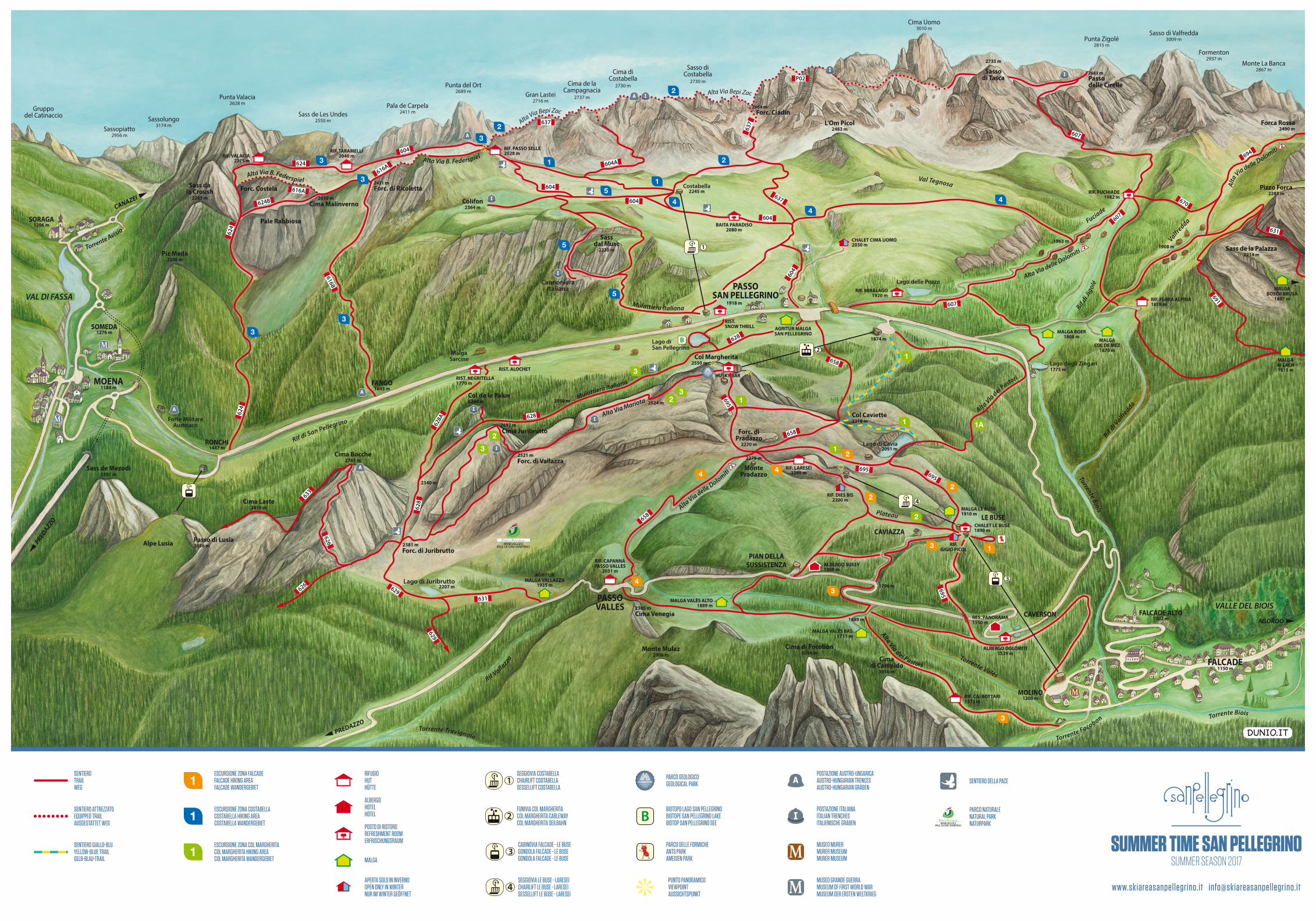
RIF. CAI BOTTARI RIF. CAPANNA PASSO VALLES RIF. LARESEI RIF. FUCHIADE RIF. MIRALAGO RIF. TARAMELLI RIF. VALACIA MALGA VALÉS BAS MALGA VALÉS ALTO AGRITUR MALGA VALLAZZA MALGA BOSCH BRUSÀ MALGA BOER MALGA COL DE MEZ AGRITUR MALGA SAN PELLEGRINO ALBERGO DOLOMITI MALGA LE BUSE CHALET LE BUSE ALBERGO SUSSY RIST. NEGRITELLA RIST. ALOCHET BAITA PARADISO RIST. SNOW THRILL CHALET CIMA UOMO RIF. DIES BIS MALGA AI LACH HUSKY BAR RIF. FLORA ALPINA RIF. PASSO SELLE RES. PANORAMA RIF. GIGIO PICOL MOLINO PIAN DELLA SUSSISTENZA CAVERSON FANGO RONCHI FALCADE ALTO SOMEDA SORAGA LE BUSE CAVIAZZA FALCADE PASSO SAN PELLEGRINO PASSO VALLES MOENA 1573 m 2031 m 1982 m 2040 m 2275 m 1711 m 1935 m 2080 m 1200 m 1529 m 1900 m 1150 m 2279 m 3010 m 3054 m 2906 m 2305 m 2521 m 2266 m 2697 m 2550 m 2483 m 2490 m 2285 m 2214 m 1302 m 2410 m 2745 m 2230 m 2364 m 1184 m 1276 m 1206 m 2203 m 2200 m 2301 m 2056 m 1818 m 2381 m 2528 m 2030 m 1867 m 1808 m 1815 m 1550 m 1889 m 1918 m 1920 m 2260 m 2200 m 1890 m 1910 m 2220 m 2630 m 2431 m 2664 m 2683 m 2091 m 2735 m 2218 m 1870 m 1770 m 1874 m 1775 m 2207 m 2340 m 2059 m 2524 m 1689 m 1796 m 1963 m 1908 m 1643 m 1447 m 2245 m Monte Pradazzo Cima di Campido Cima di Focobon Monte Mulaz Cima Venegia Forc. di Vallazza Col de le Palue Cima Juribrutto Col Margherita Forc. di Ricoletta Cima Malinverno Pale Rabbiose Forc. Costela L’Om Picol Forca Rossa Pizzo Forca Sass de la Palazza Cima Laste Cima Bocche Sass dal Musc Colifon Sass da la Croush Piz Meda Sass de Mezodì Alpe Lusia Passo di Lusia Forc. di Juribrutto Forc. di Pradazzo Forc. Ciadin Passo delle Cirelle Sasso di Tasca Col Caviette T o r r e n t e B io is Torrente Valés Torr e n t e B i o is Rif di San Pellegrino Torre n te F o c o b o n R if d i Ji g o lé Rif di Valfredda T o rre nte A visio R i f V a l l a z z a T orrente Tra vig n o l o Val Tegnosa Plateau V a lfre d da Fuciade Lago di Juribrutto Lago di Cavia Lago di San Pellegrino Lago delle Pozze Lago degli Zingari Forte Militare Austriaco Malga Sarcine Cannoniera Italiana Costabella M u lattiera Itali a n a M ulattiera Italiana A l t a V i a d e i P a s tori A l t a Via d e i P a sto ri A l t a V i a B . F e de r s p i e l A lt a Via B. Fe d e r s p i e l A l t a V i a B e p i Z a c A lta Via delle D o l o m iti Alta Via delle Dolomiti A l t a V i a delle D olomiti Alta Via Mariota Alta Via B epi Zac 695 695 628 628 628A 658 658 607 607 670 694 691 631 658 631 626 629 626 628 629 633 695 607 604 604 604 604 616A 616A 616B 624B 624 624 624 637 637 637 P02 604 604A 695 3 3 1 3 1 2 2 5 1 4 2 4 4 3 3 3 5 5 3 2 2 3 1 4 4 2 1 1 1 2 2 2 3 3 3 4 1A AGORDO PREDAZZO PREDAZZO CANAZEI Punta Valacia 2628 m Sass de Les Undes 2550 m Pala de Carpela 2411 m Punta del Ort 2689 m Gran Lastei 2716 m Cima de la Campagnacia 2737 m Cima di Costabella 2730 m Sasso di Costabella 2730 m Cima Uomo 3010 m Punta Zigolé 2815 m Sasso di Valfredda 3009 m Formenton 2937 m Monte La Banca 2867 m Gruppo del Catinaccio Sassopiatto 2956 m Sassolungo 3174 m VALLE DEL BIOIS VAL DI FASSA DUNIO.IT ALLA SCOPERTA DELLE DOLOMITI SUMMER TIME SAN PELLEGRINO SUMMER SEASON 2017 www.skiareasanpellegrino.it [email protected] SENTIERO ATTREZZATO EQUIPPED TRAIL AUSGESTATTET WEG SENTIERO TRAIL WEG SENTIERO GIALLO-BLU YELLOW-BLUE TRAIL GELB-BLAU-TRAIL ESCURSIONE ZONA COSTABELLA COSTABELLA HIKING AREA COSTABELLA WANDERGEBIET ESCURSIONE ZONA FALCADE FALCADE HIKING AREA FALCADE WANDERGEBIET ESCURSIONE ZONA COL MARGHERITA COL MARGHERITA HIKING AREA COL MARGHERITA WANDERGEBIET ALBERGO HOTEL HOTEL APERTA SOLO IN INVERNO OPEN ONLY IN WINTER NUR IM WINTER GEÖFFNET RIFUGIO HUT HÜTTE MALGA POSTO DI RISTORO REFRESHMENT ROOM ERFRISCHUNGSRAUM SEGGIOVIA LE BUSE - LARESEI CHAIRLIFT LE BUSE - LARESEI SESSELLIFT LE BUSE - LARESEI CABINOVIA FALCADE - LE BUSE GONDOLA FALCADE - LE BUSE GONDOLA FALCADE - LE BUSE SEGGIOVIA COSTABELLA CHAIRLIFT COSTABELLA SESSELLIFT COSTABELLA FUNIVIA COL MARGHERITA COL MARGHERITA CABLEWAY COL MARGHERITA SEILBAHN PUNTO PANORAMICO VIEWPOINT AUSSICHTSPUNKT PARCO DELLE FORMICHE ANTS PARK AMEISEN PARK PARCO GEOLOGICO GEOLOGICAL PARK BIOTOPO LAGO SAN PELLEGRINO BIOTOPE SAN PELLEGRINO LAKE BIOTOP SAN PELLEGRINO SEE ALLA SCOPERTA DELLE DOLOMITI MUSEO GRANDE GUERRA MUSEUM OF FIRST WORLD WAR MUSEUM DER ERSTEN WELTKRIEG MUSEO MURER MURER MUSEUM MURER MUSEUM POSTAZIONE AUSTRO-UNGARICA AUSTRO-HUNGARIAN TRENCES AUSTRO-HUNGARIAN GRÄBEN POSTAZIONE ITALIANA ITALIAN TRENCHES ITALIENISCHE GRÄBEN SENTIERO DELLA PACE PARCO NATURALE NATURAL PARK NATURPARK
Transcript of SUMMER TIME SAN PELLEGRINO - arnika.it · val di fassa dunio.it alla scoperta delle dolomiti summer...
RIF. CAI BOTTARI
RIF. CAPANNAPASSO VALLES
RIF. LARESEI
RIF. FUCHIADE
RIF. MIRALAGO
RIF. TARAMELLIRIF. VALACIA
MALGA VALÉS BAS
MALGA VALÉS ALTO
AGRITURMALGA VALLAZZA
MALGABOSCH BRUSÀ
MALGA BOER
MALGACOL DE MEZ
AGRITUR MALGA SAN PELLEGRINO
ALBERGO DOLOMITI
MALGA LE BUSE
CHALET LE BUSE
ALBERGO SUSSY
RIST. NEGRITELLA
RIST. ALOCHET
BAITA PARADISO
RIST.SNOW THRILL
CHALET CIMA UOMO
RIF. DIES BIS
MALGAAI LACH
HUSKY BAR
RIF. FLORA ALPINA
RIF. PASSO SELLE
RES. PANORAMA
RIF.GIGIO PICOL
MOLINO
PIAN DELLASUSSISTENZA
CAVERSON
FANGO
RONCHI
FALCADE ALTO
SOMEDA
SORAGA
LE BUSE
CAVIAZZA
FALCADE
PASSOSAN PELLEGRINO
PASSOVALLES
MOENA
1573 m
2031 m
1982 m
2040 m2275 m
1711 m
1935 m
2080 m
1200 m
1529 m
1900 m
1150 m
2279 m
3010 m
3054 m2906 m
2305 m
2521 m
2266 m
2697 m
2550 m
2483 m 2490 m
2285 m
2214 m
1302 m
2410 m
2745 m
2230 m
2364 m
1184 m
1276 m
1206 m
2203 m
2200 m
2301 m
2056 m
1818 m
2381 m
2528 m
2030 m
1867 m
1808 m
1815 m
1550 m
1889 m
1918 m1920 m
2260 m
2200 m
1890 m
1910 m
2220 m
2630 m
2431 m
2664 m
2683 m
2091 m
2735 m
2218 m
1870 m
1770 m
1874 m
1775 m
2207 m
2340 m
2059 m 2524 m
1689 m
1796 m
1963 m1908 m
1643 m
1447 m
2245 m
MontePradazzo
Cimadi Campido
Cima di FocobonMonte Mulaz
Cima Venegia
Forc. di Vallazza
Col de le Palue
Cima Juribrutto
Col Margherita
Forc. di Ricoletta
Cima Malinverno
Pale Rabbiose
Forc. Costela
L’Om Picol Forca Rossa
Pizzo Forca
Sass de la Palazza
Cima Laste
Cima Bocche
Sassdal Musc
Colifon
Sass dala Croush
Piz Meda
Sass de Mezodì
Alpe Lusia Passo di Lusia
Forc. di Juribrutto
Forc. diPradazzo
Forc. Ciadin
Passodelle Cirelle
Sassodi Tasca
Col Caviette
Torrente Biois
Torrente Valés
Torrente Biois
Rif di San Pellegrino
Torrente Focobon
Rif di J
igol
é
Rif di V
alfredda
Torrente Avisio
Rif Valla
zza
Torrente Travignolo
Val Tegnosa
Plateau
ValfreddaFuciade
Lago di Juribrutto
Lago di Cavia
Lago diSan Pellegrino
Lago delle Pozze
Lago degli Zingari
Forte MilitareAustriaco
MalgaSarcine
CannonieraItaliana
Costabella
Mulattiera Italiana
Mulattiera Italiana
Alta Via dei Pastori
Alta
Via dei Pastori
Alta Via B. Federspiel
Alta Via B. Federspiel
Alta Via Bepi Zac
Alta Via delle Dolomiti
Alta Via delle Dolomiti
Alta
Via delle Dolomiti
Alta Via Mariota
Alta Via Bepi Zac
695
695
628
628
628A
658
658
607
607
670
694
691
631
658
631
626
629626
628
629
633
695
607
604
604
604
604
616A
616A
616B
624B
624
624
624
637
637637
P02
604
604A
695
3
3
1
3
1
2
2
51
4
2
44
3
3
3
5
5
32
23
1
4 4
2
1
1
12
2
2
3
3
3
4
1A
AGORDO
PREDAZZO
PREDAZZO
CANAZE
I
Punta Valacia2628 m
Sass de Les Undes2550 m
Pala de Carpela2411 m
Punta del Ort2689 m Gran Lastei
2716 m
Cima de laCampagnacia
2737 m
Cima diCostabella
2730 m
Sasso diCostabella
2730 m
Cima Uomo3010 m
Punta Zigolé2815 m
Sasso di Valfredda3009 m
Formenton2937 m
Monte La Banca2867 m
Gruppodel Catinaccio
Sassopiatto2956 m
Sassolungo3174 m
VALLE DEL BIOIS
VAL DI FASSA
DUNIO.IT
ALLA SCOPERTA DELLEDOLOMITI
SUMMER TIME SAN PELLEGRINOSUMMER SEASON 2017
www.skiareasanpellegrino.it [email protected]
SENTIERO ATTREZZATOEQUIPPED TRAILAUSGESTATTET WEG
SENTIERO TRAILWEG
SENTIERO GIALLO-BLUYELLOW-BLUE TRAILGELB-BLAU-TRAIL
ESCURSIONE ZONA COSTABELLACOSTABELLA HIKING AREACOSTABELLA WANDERGEBIET
ESCURSIONE ZONA FALCADEFALCADE HIKING AREAFALCADE WANDERGEBIET
ESCURSIONE ZONA COL MARGHERITACOL MARGHERITA HIKING AREACOL MARGHERITA WANDERGEBIET
ALBERGOHOTELHOTEL
APERTA SOLO IN INVERNOOPEN ONLY IN WINTERNUR IM WINTER GEÖFFNET
RIFUGIOHUTHÜTTE
MALGA
POSTO DI RISTOROREFRESHMENT ROOMERFRISCHUNGSRAUM
SEGGIOVIA LE BUSE - LARESEICHAIRLIFT LE BUSE - LARESEISESSELLIFT LE BUSE - LARESEI
CABINOVIA FALCADE - LE BUSEGONDOLA FALCADE - LE BUSEGONDOLA FALCADE - LE BUSE
SEGGIOVIA COSTABELLACHAIRLIFT COSTABELLASESSELLIFT COSTABELLA
FUNIVIA COL MARGHERITACOL MARGHERITA CABLEWAYCOL MARGHERITA SEILBAHN
PUNTO PANORAMICOVIEWPOINTAUSSICHTSPUNKT
PARCO DELLE FORMICHEANTS PARKAMEISEN PARK
PARCO GEOLOGICOGEOLOGICAL PARK
BIOTOPO LAGO SAN PELLEGRINOBIOTOPE SAN PELLEGRINO LAKE BIOTOP SAN PELLEGRINO SEE
ALLA SCOPERTA DELLEDOLOMITI
MUSEO GRANDE GUERRAMUSEUM OF FIRST WORLD WARMUSEUM DER ERSTEN WELTKRIEG
MUSEO MURERMURER MUSEUMMURER MUSEUM
POSTAZIONE AUSTRO-UNGARICAAUSTRO-HUNGARIAN TRENCESAUSTRO-HUNGARIAN GRÄBEN
POSTAZIONE ITALIANAITALIAN TRENCHESITALIENISCHE GRÄBEN
SENTIERO DELLA PACE
PARCO NATURALENATURAL PARKNATURPARK

In co
llabo
razion
e con
Socie
tà Sto
rica “
Sul Fr
onte
dei R
icordi
” - Mo
ena
C
onsu
lente
perco
rsi: Fl
avio
Murer
AN OPEN-AIR MUSEUM
The excursions starting from the arrivai point of the Costabella chairlift or from the station uphill of the Col Margherita cableway will lead you into an area of great interest from both a naturai and historic viewpoint. During the First World War (1914-1918), the ridges of Costabella, Monzoni, Cima Bocche, and Juribrutto were high-altitude battlegrounds that witnessed fighting between the Italian army and Austrian troops, and there is a great deal of well-preserved evidence to testify to the presence of the two armies.At the same time, these trails take you through areas that are also extremely precious from a nature point of view; so much so that the Monzoni group has been called Europe's most interesting museum of geology and mineralogy.Mention should also go to the wildlife in the area, since it includes significant numbers of marmots, chamois and ibexes.
EIN FREILUFTMUSEUM
Die Wanderungen von der Station des Sessellifts Costabella sowie von der Bergstation der Seilbahn Col Margherita aus führen in ein Gebiet, das in geschichtlicher und naturkundlicher Hinsicht von grossem Interesse ist. Die Gipfel um Costabella, Monzoni, Cima Bocche und Juribrutto waren im 1. Weltkrieg (1914-1918) Schauplatz von Kämpfen im Hochgebirge zwischen dem italienischen Heer und den österreichisch-ungarischen Truppen, und zahlreiche gut erhaltene Zeugnisse weisen auf die Anwesenheit der beiden Heere hin. Gleichzeitig handelt es sich hier um Gebiete, die aus naturkundlicher Sicht so wichtig sind, dass die Monzoni-Gruppe als das interessanteste Museum für Geologie und Mineralogie bezeichnet wird.Nicht zu unterschätzen ist ausserdem die Fauna dieser Gegend angesichts zahlreicher Murmeltiere, Gämsen und Steinböcke.
COL MARGHERITA AREA
01 COL MARGHERITA • LAKE CAVIA • CAVIETTES. PELLEGRINO PASSFrom the station uphill of the cableway linking S. Pellegrino Pass to Col Margherita, the mute descends for about 1 and V2 hours along a dirt road to Lake Cavia. From the lake, it continues upwards along a Yellow - Blue trail to Caviette. From here, it continues down to S. Pellegrino Pass, arriving at the station downhill of the Col Margherita cableway, along a panoramic dirt road.Difficulty: Easy/Medium Total time: 3 hours
VARIANTE 1 A Just after the lake you can descend towards the hamlet of Zingari Bassi along an old mule trail through the forests. Once you arrive near the state road at an altitude of 1775, close to the Old Border marked Vecchio Confine, you continue left towards the cable car lift and back to San Pellegrino along a forestry road and a path that cuts through the woods.Difficulty: Easy/Medium.Total time from the lake: 1 hour and 40 minutes
02 COL MARGHERITA • CIMA JURIBRUTTO AND BACKFrom the station uphill of the Col Margherita cableway, take the path on the right - the Alta Via Mariota - to cross trenches and outposts from the First World War as far as Cima Juribrutto and then back again.Difficulty: Medium Total time: 3 hours approx.
03 COL MARGHERITA • VIA JURIBRUTTO • S. PELLEGRINO PASSThis mute covers the whole Alta Via Mariota as far as Forcella Juribrutto. From here it is possible to go up to Cima Bocche (2.745 m) and then to take route no. 628 back to S. Pellegrino Pass.Difficulty: Medium Total time: 5 hours
We recommend a visit to the little lake in Juribrutto, not far beneath the namesake Pass. Follow the path marked Sent. 629-631
FALCADE AREA
01 LE BUSEIn Le Buse, from the station uphill of the gondola Falcade-LeBuse,it is possible to visit the Ant Park, where you can learn the secrets of these useful and hardworking woodland insects.Difficulty: Easy Total time: 30 min.
02 LE BUSE- LAKE CAVIA AND BACKFrom the station uphill of the gondola Falcade-LeBuse, take the mute no. 695 and in about 50 minutes, you will mach Lake Cavia. From here, continue up towards Cima Pradazzo. Passing from the Laresei refuge, you will return to Le Buse on the Plateau Piste.Difficulty: Medium Total time: 2 hours 30 min.
03 LE BUSE - MOLINO - VIA THE BOTTARI REFUGEFrom the station uphill of the gondola Falcade-LeBuse, take the Caviazza road on the left as far as the Provincial Boad. Follow the signs as far as the fork for Malga Vales Bas. From here, follow the signs for the Bottari Befuge, 45 minutes away After reaching the refuge, the mute continues down to Molino - Falcade.Difficulty: Easy / Medium Total time: 2 hours 40 min.
04 PASSO VALLES - CIMA PRADAZZO - LARESEI REFUGEFrom Passo Valles, near to the refuge of the same name, there is a dirt road up to Cima Pradazzo. From here it is possible to continue towards Col Margherita or to Lake Cavia, or even to the Laresei Refuge.Difficulty: Easy Total time: 1 hour
05 LARESEI-CIMA PRADAZZOFrom the upper chairlift station Le Buse-Laresei, start walking straightforward towards the mountain hut Laresei then walk down rightwards to the mountain lake Lago Cavia (1 hr). From here, you can walk towards Le Buse (30 min.) or walk down towards "Molino" taking the trail no. 695 along the way-back ski slope to Falcade (thr.) lime: 2hr.30 minDifficulty: Medium Total time: 2 hours 30 min
COSTABELLA AREA
01A trail sets out from the station uphill of the Costabella chairlift up to the Passo delle Selle Refuge.Difficulty: Easy Total time: 45 minutes
02 ALTA VIA BEPI ZACThe Bepi Zac via ferrata starts out from the Passo delle Selle Refuge, taking you along what was the Austrian front during the First World War, with its trenches, tunnels, remains and huts and emplacements, and then on to Forcella Ciadin and back along route no. 637 to the station uphill of the Costabella chairlift.Difficulty: Medium/Hard (it's recommended a security short rope)Total time: 5-6 hours
03 ALTA VIA FEDERSPIEL (Ferrata Monzoni)From the Passo delle Selle Refuge, follow the path 616 along the remains of the warpath. Keep on walking on the equipped tract until Forcella Ricoletta (2,5 h tram Passo delle Selle). From here you can walk down towards Loc. Fango (616b), about 4,5 km from S. Pellegrino Pass (1,5 h) or walk to Cima Malinverno and to Forcella Costella (1,5 h from Forcella Ricoletta). From here you reach Loc. Ronchi (624) and walk down to Moena. From Forcella Costella you can get at Refuge Valada and walk back to Passo delle Selle, passing by Refuge Taramelli (3,5 h). A good organization of the transports is needed.Difficulty: Medium/Hard (it's recommended a security short rope)Total time: 5-7 hours
04 EASY WALKFrom the arrivai of the Costabella chairlift, descend as far as the Paradiso Refuge. At the fork just below the refuge, continue straight on Val Tegnosa for about 40 minutes to arrive at the road to Fuchiade, which will take you back to Passo S. Pellegrino.Difficulty: Easy Total time: 2 hours
05 HISTORICH ROUTEFrom the end of the Costabella chairlift, follow the indications to "Colifòn la linea italiana" and "Mulattiera italiana del Sas dal Musc". Across the pastures till the Sas dal Musc (2.230 m) and the Colifòn (2.370 m), where you can find refuges and embrasures of the italian army during First World War (get a torch). Follow the indications from that point.Difficulty: Easy Total time: 2,5-3 hours
COL MARGHERITA AREA
01 COL MARGHERITA • CAVIA SEE • CAVIETTE • S. PELLEGRINO PASSVon der Bergstation der Seilbahn, die den San Pellegrino Pass mit Col Margherita verbindet, gelingt man abwàrts nach 1h A auf einem Schotterweg zum Cavia See. Vom See aus steigt man auf dem gelb-blauen Weg zuruck in das Caviette Gebiet. Von hier aus geht man zum San Pellegrino Pass hinab, zur Talstation der Seilbahn Col Margherita, eine PanoramastraBe entlang.Schwierigkeit: Einfach /Mittel Dauer: 3 Stunde
VARIANTE 1 A Gleich hinter dem See können Sie auf einem alten Maultierpfad durch den Wald Richtung Zingari Basse absteigen. Wenn Sie dann auf 1.775 m Höhe in der Nähe der ehemaligen Grenze die Staatsstrasse erreichen, halten Sie rechts auf die Seilbahn und San Pellegrino zu und folgen dem Weg durch den Wald.Schwierigkeit: Einfach/Mittel.Gesamtzeit ab dem See: 1 Stunde und 40 Minuten.
02 COL MARGHERITA • JURIBRUTTO SPITZE UND ZURUCKVon der Bergstation der Seilbahn Col Margherita, den Weg rechts, der Alta Via Mariota entlang, gelingt man zur Spitze Juribrutto und zuruck, wobei man an Schutzengràber und Festungen des Ersten Weltkrieges vorbeikommt.Schwierigkeit: Mittel Dauer: ungefàhr 3 Stunden
03 COL MARGHERITA • VIA JURIBRUTTO • S. PELLEGRINO PASSDer Alta Via Mariota entlang bis zur Juribrutto Scharte, wo man eventuell bis zur Bocche Spitze (2745 m.) welter gehen kann, um dann auf dem Weg 628 entlang bis zum San Pellegrino Pass zuruckzukehren.Schwierigkeit: Mittel Dauer: 5 Stunden
Wir empfehlen auch einen Besuch am Juribrutto-See, kurz unterhalb Scharte gleichen Namens. Wanderweg 629-631.
FALCADE AREA
01 LE BUSEIn der Ortschaft Le Buse, von der Bergstation der Kabinenbahn Falcade-Le Buse, kann man den Ameisenpark besichtigen, um Geheimnisse dieser nutzlichen Insekten des Waldes zu entdecken.Schwierigkeit: Einfach Dauer: 30 Minuten
02 LE BUSE • CAVIA SEE UND ZURUCKVon der Bergstation der Kabinenbahn Falcade-Le Buse aus, den Pfad 695 entlang, erreicht man den Cavia See. Von hier aus steigt man zur Pradazzo Spitze. Vorbei an der Schutzhutte Laresei kommt man der Plateau Piste entlang, zuruck zu Le Buse.Schwierigkeit: Mittel Dauer: 2 Stunden und 30 Minuten
03 LE BUSE • MOLINO • SCHUTZHUTTE BOTTARIVon der Bergstation der Kabinenbahn Falcade-Le Buse, links den Weg der Caviazza entlang bis zur LandesstraBe. Den blau-weiBen Anzeigen bis zur Abzwei-gung der Vales Bas Alm folgen. Von hier aus den Anzeigen tur die Bottari- Schutzhutte folgen, die 45 min. entferntist. Nachdem man die Schutzhutte erreicht hat, geht man abwàrts welter bis zur Ortschaft Molino-Falcade.Schwierigkeit: Einfach/Mittel Dauer: 2 Stunden und 40 Min.
04 VALLES JOCH • PRADAZZO SPITZE • SCHUTZHUTTE LARESEIAm Valles Joch, an der gleichnamigen Schutzhutte, startet ein Schotterweg der uns zur Pradazzo Spitze fuhrt. Von hier aus ist es mòglich entweder zum Col Margherita oder zum Cavia See zu gelangen. Oder aber auch zu den Schutzhutten Laresei. Schwierigkeit: Einfach Dauer: 1 Stunde
05 LARESEI • CIMA PRADAZZOAus der Bergstation der Sesselbahn Le Buse-Laresei gehen Sie geradeaus bis zur Berghutte Laresei und dann gehen Sie rechts hinunter, in Richtung Lago Cavia (1 Std.). Von hier kónnen Sie nach Le Buse (30 Min.) gehen und eventuell kónnen Sie den Weg 695 entlang die Skipiste nach “Molino” hinuntergehen, die zuruck nach Falcade (1 Std.) fuhrt.Schwierigkeit: Mittel Dauer: 2 Stunden und 30 Minuten
COSTABELLA AREA
01Von der Bergstation der Seilbahn Costabella brìngt ein Wanderweg zur Bergvagabunden Hutte (Rifugio Passo delle Selle).Schwierigkeit: Einfach Dauer: 45 Minuten
02 ALTA VIA BEPI ZACBei der Bergvagabunden Hutte, beginnt der ausgestattete Bergweg Bepi Zac�der, der òsterreich-italienischen Front entlang, vorbei an Schutzengràber, Gal-lerien und Barackenreste uns zur Ciadin Scharte fuhrt. Von hier aus gelangt man uber den Weg 637 zuruck zur Bergstation der Seilbahn Costabella.Schwierigkeit: MittelSchwer Dauer: 5-6 Stunden (man empfiehlt das Sicherungsseil)
03 ALTA VIA FEDERSPIEL (Ferrata Monzoni)Bei der Bergvagabunden Hutte, dem Wanderweg 616, entlang Kriegsspuren, folgen. Welter geht es auf ausgesattenem Wanderweg bis zur Ricoletta Schar te (Zweieinhalb Stunden von der Bergvagabunden Hutte enfernt). Von hier aus kann man zur Ortschaft Fango (616b) absteigen, die ungefàhr 4,5 km vom San Pellegrino Pass (1,5 h) enfernt ist, oder welter gehen bis zur Malinverno Spitze und der Costella Scharte (1,5 h von der Ricoletta Scharte) und fort- setzen bis zu Molveno. Von der Costella Scharte ist es auch mòglich zu der Valacia Schutzhutte abzusteigen und uber der Taramela Schutzhutte (3,5 h), an der Vagabunden Hutte zuruckzukehren. Dieser Wanderweg setzt eine sehr gute Organisation was Transporte angeht, voraus.Schwierigkeit: Mittel - SchwerDauer: 5-7 Stunden (man empfiehlt das Sicherungsseil)
04 EINFACHER SPAZIERGANGVon der Ankunft der Costabella Seilbahn, absteigen bis zur Schutzhutte Paradiso. An der Abzweigung knapp unter der iSchutzhutte, immer gerade aus Richtung Tegnosa Tal, um nach ca. 40 Minuten sich auf der StraBe zu befinden die nach Fuchiade fuhrt, auf der man zum San Pellegrino Pass zuruckkehren kann.Schwierigkeit: Einfach Dauer: 2 Stunden
05 HISTORISCHE ROUTEVon der Ankunft der Costabella Seilbahn, die Hinweise "Colifòn linea italiana " und "Mulattiera italiana del Sas dal Musc” folgen. Uber Weiden gelangt man zum Sas dal Musc (2230 m.) und zum Colifòn (2370 m.), wo man auf Zufluchtstàtte und SchieBscharten der italienischen Armee wàhrend ersten Weltkrieges stòBt ( man ruste sich mit einer Taschenlampe aus). Von hier aus den Hinweisen folgen.Schwierigkeit: Einfach Dauer: 2,5-3 Stunden
ZONA COL MARGHERITA
01 COL MARGHERITA • LAGO CAVIA • CAVIETTEPASSO SAN PELLEGRINODalla stazione a monte della funivia che collega il Passo San Pellegrino con il Col Margherita si scende per ca. 1 ora e mezza lungo la strada sterrata e si raggiunge il Lago Cavia. Dal lago si risale per il sentiero giallo-blu verso la zona delle Caviette. Di lì si scende al Passo San Pellegrino, alla stazione a valle della funiviaCol Margherita, percorrendo una panoramica strada sterrata.Difficoltà: Facile/Media Tempo totale: 3 ore
VARIANTE 1 AAppena dopo il lago Cavia è possibile scendere verso località Zingari Bassi tramite una antica mulattiera nel bosco, arrivati nei pressi della strada statale a quota 1775 m. vicino al Vecchio Confine si prosegue a sinistra verso la Funivia del San Pellegrino per una strada forestale e un sentiero nel bosco.Difficoltà: Facile/Media Tempo totale dal lago: 1 ora e 40 minuti
02 COL MARGHERITA • CIMA JURIBRUTTO E RITORNODalla stazione a monte della Funivia Col Margherita, prendendo il sentiero di destra: l'Alta Via Mariotta, è possibile camminando in quota attraversare trincee e avamposti della Prima Guerra Mondiale e raggiungere la Cima Juribrutto e poi ritornare.Difficoltà: Media Tempo totale: 3 ore circa 03 COL MARGHERITA • VIA JURIBRUTTO • PASSO S. PELLEGRINOSi completa l'Alta Via Mariotta fino a Forcella Juribrutto, ed eventualmente si può salire fino a Cima Bocche (2.745 m.), per poi prendere il sentiero n. 628 e ritornare al Passo San Pellegrino.Difficoltà: Media Tempo totale: 5 ore
Si consiglia una visita al laghetto di Juribrutto, poco sotto l'omonima forcella. Sentieri 629-631
ZONA FALCADE
01 LE BUSEIn località le Buse dalla stazione a monte della cabinovia Falcade-Le Buse è possibile visitare il Parco delle Formiche, alla scoperta dei segreti di questi utili e laboriosi insetti del bosco.Difficoltà: Facile Tempo totale: 30 min.
02 LE BUSE • LAGO DI CAVIA E RITORNODalla stazione a monte della cabinovia Falcade-Le Buse si percorre il sentiero n. 695 e in 50 minuti ca. si raggiunge il Lago Cavia. Da lì si risale verso la Cima Pradazzo. Transitando dal Rifugio Laresei si ritorna in località Le Buse dalla Pista Plateau.Difficoltà: Media Tempo totale: 2 ore 30 min
03 LE BUSE • MOLINO • VIA RIFUGIO BOTTARIDalla stazione a monte della cabinovia Falcade-Le Buse si prende a sinistra la strada della Caviazza fino a raggiungere la Strada Provinciale. Seguire le segnalazioni bianco-blu fino al bivio per malga ValesBas. Da lì si prosegue per il Rifugio Bottari a 45 minuti. Dopo aver raggiunto il rifugio si scende verso la località Molino-Falcade.Difficoltà: Facile / Media Tempo totale: 2 ore 40 min.
04 PASSO VALLES • CIMA PRADAZZO • RIFUGIO LARESEIDal Passo Valles, in prossimità dell'omonimo rifugio, parte una strada sterrata che fa raggiungere Cima Pradazzo. Da qui è possibile andare verso il Col Margherita, verso il Lago Caviao verso il rifugio Laresei.Difficoltà: Facile Tempo totale: 1 ora
05 LARESEI • CIMA PRADAZZODall'arrivo della seggiovia Le Buse-Laresei procedere diritto verso il Rifugio Laresei per poi scendere verso destra in direzione del Lago Cavia (1 ora). Da qui si può procedere verso Le Buse (30 min) ed eventualmente continuare fino a "Molino" con il sentiero 695 lungo la pista da sci di rientro a Falcade. (1 ora)Difficoltà: Media Tempo totale: 2 ore 30 min.
ZONA COSTABELLA
01Dalla stazione a monte della Seggiovia Costabella inizia un sentiero che raggiunge il Rifugio Passo delle Selle.Difficoltà: Facile Tempo totale: 45 minuti
02 ALTA VIA BEPI ZACDal Rifugio Passo delle Selle inizia il sentiero attrezzato Bepi Zac che, lungo il Fronte Austriaco-Italiano della Prima Guerra Mondiale con trincee, gallerie, resti di baracche e postazioni, ci porta verso la Forcella Ciadin da dove, con il sentiero n. 637, si rientra alla stazione a monte della seggiovia Costabella.Difficoltà: Medio/Difficile (si consiglia il cordino di sicurezza) Tempo totale: 5-6 ore
03 ALTA VIA FEDERSPIEL (Ferrata Monzoni)Dal Rifugio Passo delle Selle seguire il sentiero n. 616 percorrendo le tracce della grande guerra. Si prosegue su tratto attrezzato fino alla Forcella Ricoletta (2,5 ore dal Passo delle Selle). Da qui si può scendere verso località Fango (n. 616b) a ca. 4,5 km dal Passo San Pellegrino (1,5 ore) oppure proseguire fino a Cima Malinverno e Forcella della Costella (1,5 ore da Forcella Ricoletta) per scendere a località Ronchi (n. 624) e proseguire per Moena. Da Forcella Costella è possibile anche scendere verso il Rifugio Valacia e rientrare al Passo delle Selle passando per il Rifugio Taramelli(3,5 ore). Questo percorso richiede un'accurata organizzazione dei trasporti.Difficoltà: Medio/Difficile (si consiglia il cordino di sicurezza) Tempo totale: 5-7 ore
04 PASSEGGIATA FACILEDall'arrivo della seggiovia Costabella scendere fino al Rifugio Paradiso. Al bivio poco sotto il Rifugio proseguire diritto verso Val Tegnosa per congiungersi dopo circa 40 minuti alla strada che conduce a Fuchiade lungo la quale si rientra al Passo San Pellegrino.Difficoltà: Facile Tempo totale: 2 ore
05 ITINERARIO STORICODall'arrivo della seggiovia Costabella seguire le indicazioni "Colifòn la linea italiana" e "Mulattiera italiana del Sas dal Musc". Attraverso i pascoli si raggiungono il Sas dal Musc (2.230 m.) ed il Colifòn (2.370 m.), dove si trovano i ricoveri e le cannoniere utilizzate durante la Prima Guerra Mondiale dall'esercito italiano (munirsi di torcia). Seguire la segnaletica in loco.Difficoltà: Facile Tempo totale: 2,5-3 ore
Verso il Passo delle Selle
UN MUSEO A CIELO APERTO
Le escursioni che partono dall'arrivo della Seggiovia Costabella e dalla stazione a monte della Funivia Col Margherita conducono in un territorio interessante dal punto di vista storico e naturalistico.Le Creste di Costabella, dei Monzoni, Cima Bocche, Juribrutto furono teatro durante il Primo Conflitto Mondiale (1914-1918) di battaglie in alta quota fra l'esercito italiano e le truppe austriache.Le testimonianze della presenza dei due eserciti sono numerose e ben conservate.Si tratta comunque di percorsi che si sviluppano in zone estremamente preziose dal punto di vista naturalistico tanto che i Monzoni sono stati definiti il museo geologico e mineralogico più interessanti d'Europa.Interessante inoltre è l'aspetto faunistico della zona vista la frequenza con cui si incontrano marmotte, camosci e stambecchi.
in c
olla
bora
zion
e co
n S
ocie
tà "
Sul f
ront
e de
i ric
ordi
"-M
oena
con
sule
nte
perc
orsi
Fla
vio
Mur
er
SUMMER TIME SAN PELLEGRINOSUMMER SEASON 2017
ESCURSIONI · EXCURSIONS · WANDERUNGENSUMMER TIME SAN PELLEGRINO
SkiAreaSanPellegrino.DolomitiCol Margherita Freeride Park
SkiAreaSanPe
Passo San PellegrinoLoc. CostabellaTel. (+39) 0462 [email protected] Col MargheritaTel. (+39) 0462 573676
FalcadeLoc. MolinoTel. (+39) 0437 [email protected] Le BuseTel. (+39) 0437 599083
Uffici skipass / Skipass offices
ALLA SCOPERTA DELLEDOLOMITI
www.skiareasanpellegrino.it/estate/col-margherita-park
Per informazioni e per prenotazioni tour guidati - For informations and guided tours bookings:
U�cio Perle Alpine di Moena – tel. 0462 565038