Preliminary Observation on the Neolithic Settlement...
26
Riassunto Vengono esaminati i cambiamenti dei modelli di insediamento carat- teristici delle società neolitiche nel Sudan centrale dal VI millennio B.C. fino alla fine del IV millen- nio. Per presentare la struttura degli insediamenti, si utilizzano le informazioni disponibili sulla distribuzione nella regione dei siti neolitici, e si discutono inoltre bre- vemente la cronologia e gli aspetti sociali del Neolitico. In conclusio- ne, si rileva che lo studio dei “mo- delli di insediamento” è difficile, poiché utilizziamo un numero così limitato di siti per comprendere la cultura di un’area più vasta. Non è quindi chiaro se i modelli che possiamo individuare riflettano le situazioni reali che esistevano du- rante il periodo neolitico. Summary This paper investigates the changes in settlement patterns characteris- tic of Neolithic societies in Central Sudan from the Sixth to the late Fourth millennium BC. It uses the available information on the dis- tribution of the Neolithic sites from this region to present the structure of settlement. It also discusses in brief the chronology and the social aspects of the Neolithic in the re- gion. The paper concludes that the study of “settlement patterns” is a difficult one since we are using so few sites to understand the culture in a wider area. Accordingly, it is not clear whether the settlement patterns we see reflect the real situ- ations that existed during the Neo- lithic Period. Résumé L’auteur examine les changements des modèles de peuplement carac- téristiques des sociétés néolithiques au Soudan central, du VI e millénaire jusqu’à la fin du IV e millénaire av. J.- C. La structure du peuplement est présentée à partir de l’information disponible sur la distribution des sites néolithiques dans la région. On discute aussi brièvement de la chronologie et des aspects sociaux du Néolithique de la région. Pour conclure, on observe qu’une étude des «modèles de peuplement» est difficile, puisque le nombre des sites est si limité qu’il ne nous permet pas de comprendre la culture d’une région plus vaste. Il n’est donc pas sûr que les modèles que nous pou- vons identifier reflètent les situa- tions réelles qui existaient pendant la période néolithique. Preliminary Observation on the Neolithic Settlement Patterns in Central Sudan Azhari Mustafa SADIG * * Dept. of Archaeology University of Khartoum Introduction The term “settlement patterns” is applied when a group of people occu- pies a particular geographical region to exploit its resources. The study of settlement patterns means the study of the relationship between the people, particularly the prehistoric ones, their environment, and how they culturally and economically adapted themselves to the environ- ment in which they were living. The studies of the material remains (cultural and biological) are basic in achieving these objectives. There- fore, the study of settlement pattern is very important because it gives us information about the environment, technology and social organiza- tion. Generally, settlement patterns are defined as the result of relation- ships between people who decided, for practical, political, economic, and social considerations, to place their houses, settlements, and religious structures where they did (Nir, 1983). Another definition, which was for- warded by Bruce Trigger, suggests that two approaches have dominated the “settlement pattern” (Trigger, 1968: 54). The first is primarily ecological and often appears to be based on the assumption that the “settlement pattern” is a product of the simple in- teraction of two variables: environment and technology. This kind tends to be concerned with the size and the distribution of the whole sites. The second kind of approach uses the data as a basis for making inferences about the social, political and religious organization of prehistoric cul- SAHARA 20/2009 Sadig 31 ALL RIGHTS RESERVED - TOUS DROITS RESERVES www.saharajournal.com
Transcript of Preliminary Observation on the Neolithic Settlement...
Riassunto
Vengono esaminati i cambiamenti dei modelli di insediamento carat-teristici delle società neolitiche nel Sudan centrale dal VI millennio B.C. fino alla fine del IV millen-nio. Per presentare la struttura degli insediamenti, si utilizzano le informazioni disponibili sulla distribuzione nella regione dei siti neolitici, e si discutono inoltre bre-vemente la cronologia e gli aspetti sociali del Neolitico. In conclusio-ne, si rileva che lo studio dei “mo-delli di insediamento” è difficile, poiché utilizziamo un numero così limitato di siti per comprendere la cultura di un’area più vasta. Non è quindi chiaro se i modelli che possiamo individuare riflettano le situazioni reali che esistevano du-rante il periodo neolitico.
Summary
This paper investigates the changes in settlement patterns characteris-tic of Neolithic societies in Central Sudan from the Sixth to the late Fourth millennium BC. It uses the available information on the dis-tribution of the Neolithic sites from this region to present the structure of settlement. It also discusses in brief the chronology and the social aspects of the Neolithic in the re-gion. The paper concludes that the study of “settlement patterns” is a difficult one since we are using so few sites to understand the culture in a wider area. Accordingly, it is not clear whether the settlement patterns we see reflect the real situ-ations that existed during the Neo-lithic Period.
Résumé
L’auteur examine les changements des modèles de peuplement carac-téristiques des sociétés néolithiques au Soudan central, du vie millénaire jusqu’à la fin du ive millénaire av. J.-C. La structure du peuplement est présentée à partir de l’information disponible sur la distribution des sites néolithiques dans la région. On discute aussi brièvement de la chronologie et des aspects sociaux du Néolithique de la région. Pour conclure, on observe qu’une étude des «modèles de peuplement» est difficile, puisque le nombre des sites est si limité qu’il ne nous permet pas de comprendre la culture d’une région plus vaste. Il n’est donc pas sûr que les modèles que nous pou-vons identifier reflètent les situa-tions réelles qui existaient pendant la période néolithique.
Preliminary Observation on the Neolithic Settlement Patterns in Central Sudan
Azhari Mustafa Sadig*
* Dept. of Archaeology University of Khartoum
IntroductionThe term “settlement patterns” is applied when a group of people occu-pies a particular geographical region to exploit its resources. The study of settlement patterns means the study of the relationship between the people, particularly the prehistoric ones, their environment, and how they culturally and economically adapted themselves to the environ-ment in which they were living. The studies of the material remains (cultural and biological) are basic in achieving these objectives. There-fore, the study of settlement pattern is very important because it gives us information about the environment, technology and social organiza-tion. Generally, settlement patterns are defined as the result of relation-ships between people who decided, for practical, political, economic, and social considerations, to place their houses, settlements, and religious structures where they did (Nir, 1983). Another definition, which was for-warded by Bruce Trigger, suggests that two approaches have dominated the “settlement pattern” (Trigger, 1968: 54).
The first is primarily ecological and often appears to be based on the assumption that the “settlement pattern” is a product of the simple in-teraction of two variables: environment and technology. This kind tends to be concerned with the size and the distribution of the whole sites. The second kind of approach uses the data as a basis for making inferences about the social, political and religious organization of prehistoric cul-
SAHARA 20/2009 Sadig 31
ALL RIGHTS RESERVED - TOUS DROITS RESERVES
www.saharajournal.com
tures. This concentrates on the patterning within the individual settle-ment. Settlement sites in these definitions are the ones around which a group of people centered their daily activities. That means a “settle-ment” refers to a domestic activity. Generally, the distribution of sites is the most important information for any archaeological interpretation because it gives us the clues for answering many questions regarding adaptation. Moreover, the type of settlement sites gives us information, which is very closely related to the environment, technology, and social organization. The settlement site can also be called “habitation site” and it is the most commonly excavated type of sites because these are the places where the prehistoric people lived. Most of the information about the past cultures is retrieved from such sites. It is often the case that settlement sites encompass a group of a smaller special kind of sites such as quarry sites, sites for pottery production, tool making... etc.
Prehistoric ConditionEvidence for paleoecological changes has been evaluated in Wickens (1982). The data are geological, archaeological and biological; they suggest that there have been significant climatic and ecological changes in the Sudan during the past 40000 years. The main paleoclimatic conclusions can be summarized as follows:
1. During the terminal Pleistocene the climate was cool, dry and windy at least as far south as latitude 10-12 N, and was probably semi-arid throughout much of southern Sudan.
2. The early to middle Holocene (c. 10500 - 6000 years B.P.) was wet and warm in central Sudan and the present savanna zone of western Sudan. Late Pleistocene dunes became submerged beneath White Nile alluvium in central Sudan, and further west small lakes and swamps occupied the depressions between the now vegetated and stabilized dunes.
3. From about middle Holocene times onwards the climate became drier, and there was a progressive shift southwards of the rainfall, vegetation and faunal zones. Man’s influence upon his environment became increasingly pronounced (Wickens, 1982: 30).
Wickens also identified the following climatic changes for the period from 20000 BP to present:
Phase A. Very arid phase; 20000-15000 BP. Phase B. Comparable to the present climatic phase; 15000-12000 BP. Phase C. Very wet phase; 12000-7000 BP. Phase D. Short dry phase; 7000-6000 BP. Phase E. Wet phase; 6000-3000 BP. Phase F. Present climatic phase; c. 3000 BP until today.
Some of the fossil evidence used to characterize some of the periods is the following:
a. The discovery of the fruits of Celtis integrifolia at Khartoum Hospital site and Shaheinab (Arkell, 1949, 1953). The northern limit of present-day distribution of this tree is corresponding with the 400 mm isohyet. The present-day rainfall of Khartoum is 163 mm while that at Shaheinab is estimated to be about 100 mm. The minimum climatic shift necessary to obtain a rainfall of 400 mm at Shaheinab is in the order of 150 km north during the period E (Wickens, 1975: 46).
b. The oil palm (Elaeis guineensis) was discovered at Nyama Suq in Darfur in a deposit dated between 12000 and 3500 BP in the time-span covered by phase C (12000-7000 BP). It is estimated that a northward shift in the climatic and vegetation belts of at least 400 km would be required to explain the presence of oil palm on Jebel Marra. The nearest known locality for oil palm today is from 600 km further south and just across the border into the Central African Republic (Wickens, 1975: 47). A carbonized fragment of oil palm was also discovered at Shaheinab (Arkell, 1953). The oil palm occurs
32 SAHARA 20/2009 Sadig
ALL RIGHTS RESERVED - TOUS DROITS RESERVES
www.saharajournal.com
north of Yei, in an area receiving approximately 1200 mm rainfall per annum. Consequently, the Shaheinab specimen must either have been transported down the Nile by either man or flood waters or, what is perhaps more likely, brought from Darfur by travelers (Wickens, 1975: 48).
c. The presence of Acacia sp., Salvadora persica, Ziziphus sp., and Ficus sp. at Jebel Tomat, dated to the period between 1930 and 1705 ± 60 BP and so they belong to period F (about 3000 BP until today). These species are not representative of any particular community; they are merely suggestive of dry-land vegetation rather similar to that found in the area today.
d. The abundance of subfossil Limicolaria cailliaudi at Khartoum and Shaheinab (Arkell, 1949, 1953) indicated that the snail was flourishing and therefore suggestive of a rainfall in excess of 400 mm. This would suggest a northward isohyet shift of at least 300 km for period E (Wickens, 1975: 50). The fauna that can be referred to this period is from the Neolithic site of Shaheinab. This consists of 32 species of mammals, of which 3 are domestic. The buffalo, giraffe and the hippopotamus were most abundant. There is a noticeable absence of swamp-loving animals such as the Nile Lechwe, which were recorded from the Mesolithic site of Khartoum. The absence does not imply a reduction in rainfall as Arkell suggested (1953), merely an absence of swamps (Fig. 1).
Beside these evidences there are also other indications that conditions were different in the Neolithic from the present situation. Arkell suggests that the flood level of the Nile was higher and it was as much as 5 meters above the alluvial plain surrounding the Shaheinab site and was partly inundated by the Nile. The Nile being 5 meters higher during the flood implied that the floodplain was around 6 km wider in the eastern area (the plain slopes slightly higher eastwards) (Haaland, 1981: 46). The part of the alluvial plain suitable for human habitation was thus much smaller in Neolithic times than today. Only a narrow belt at the eastern edge of the floodplain was probably available for cultivation during the
SAHARA 20/2009 Sadig 33
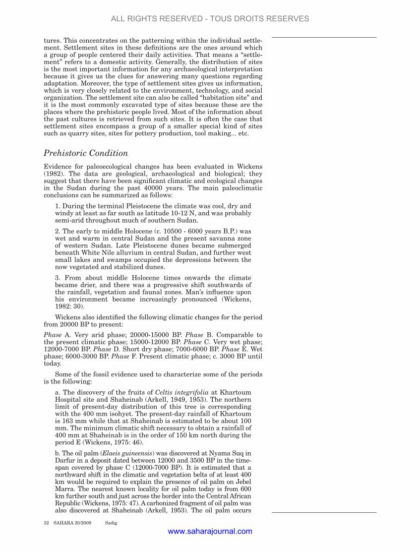
Fig. 1. Climate-controlled occupation in the Eastern Sahara and Sudan during the main phases of the Holocene.
A) After 7000 B.C.E., human settlement became well established all over the Eastern Sahara, fostering the development of cattle pastoralism.
(B) Retreating monsoonal rains caused the onset of desiccation of the Egyptian Sahara at 5300 B.C.E.
Prehistoric populations were forced to the Nile valley or ecological refuges and forced to exodus into the Sudanese Sahara where rainfall and surface water were still sufficient. The return of full desert conditions all over Egypt at about 3500 B.C.E. coincided with the initial stages of pharaonic civilization in the Nile valley.
ALL RIGHTS RESERVED - TOUS DROITS RESERVES
www.saharajournal.com
rainy season although we have no real evidence for cultivation in the Neolithic. When the Nile receded in the dry season, an area between Kadero I, II, Um Direiwa I, II and Zakiab would have been laid bare and provided good pasture for the domestic stocks (Haaland, 1981: 46). The volume of the Nile could have been increased by a higher amount of rainfall either in the headwater of the White Nile or the Ethiopian highlands. High lake levels have been attested from the East African lakes between the ninth to the third millennia BC, with a peak about 7000 BC (Zindern Bakker, 1972; Butzer et al., 1972: 1069-1076). Not only was the level of the Nile higher but there was also considerably higher local rainfall. Arkell compares the situation of the Khartoum area with that of the Malakal area today (Arkell, 1953: 7-9), a view also adopted by Butzer, who suggests a 300 km northward shift of the Zonal vegetation belts (Butzer & Hansen, 1968). With regard to the four sites studied by Tigani el Mahi, the amount of rainfall in the Central Nile Neolithic was estimated on the bases of recovered faunal remains from Shaheinab, Zakiab, Um Direiwa and Nofalab site (Tigani el Mahi, 1982). Among these animals we have the warthog, the black rhinoceros, giraffe and roan antelope. They indicate that the rainfall during the Neolithic time of the Khartoum district had been ranging between 300-700 mm. The following list shows the faunal remains at Zakiab and the minimum amount of rain required by various species (based on work done by Ali Tigani el Mahi: 1982).
Warthog requiring a minimum of 300 mm Roan antelope ........................................ 500 mm Tiang antelope ........................................ 500 mm White-eared Kob ........................................ 500 mm Waterbuck ........................................ 500 mm
On the basis of the above-mentioned data Ali Tigani el Mahi suggests that the rainfall would have been not less than 500 mm per year (1982: 179). On the basis of plant remains of Celtis integrifolia we may furthermore infer that the precipitation was probably above 500 mm. The paleobotanical evidence also showed the presence of Sorghum bicolour, morphologically not domesticated from Zakiab, Kadero I and Um Direiwa I (Haaland, 1981: 47). This plant requires above 500 mm of rain yearly but this is not significant if it is grown near the river on wet alluvium. The paleobotanical and osteological material identified from the Kadero I site strongly suggests the same climatological conditions as were found from Zakiab. The material yielded evidence of Celtis (Krzyżaniak, 1977: 166) and the remains of land snails like Ampultaria and Limicolaria flammata (Krzyżaniak, 1977: 171). According to Haaland (1981), the Khartoum Nile environment during Neolithic times would have consisted of three microenvironments, besides the river itself:
a. The alluvial plain east of the high flood level of the Nile, i.e. east of the 4 base sites (Kadero I, II and Um Direiwa I, II).
b. The alluvial plain lay bare during the dry season, when the Nile was low, i.e. the area between the base sites and the dry season camp site (Zakiab site).
c. The higher area east of the alluvial plain, the Butana, which would have consisted of a woodland savanna type of vegetation (Haaland, 1981: 47).
More relevant to the paleoclimatical condition of the Central Sudan are evidences from the Shaqadud excavations in the Western Butana (Marks & Mohammed Ali, 1991). Today, the area of Shaqadud fall within the semi-desert zone of north-central Sudan with very precarious summer rainfall not exceeding 150 mm at best (Whiteman, 1971: 5). Rarely, the area receives a reasonable amount of rains to the point that it fills watercourses and small depressions for some time. The general rule, however, is that of desert conditions which limit the area’s potential available for both animal and the sparse semi-nomadic population (El Amin, 1992: 47). Along the main wadis and water courses grow a number of Acacia species, shrubs and seasonal short grasses which provide grazing for animals. According to El Amin (1992: 50) climatic condition during the Holocene were certainly conductive to human settlement as is suggested
34 SAHARA 20/2009 Sadig
ALL RIGHTS RESERVED - TOUS DROITS RESERVES
www.saharajournal.com
by the environmental data obtained from the excavation areas at the cave of Shaqadud and from some of the survey sites. The fauna is remarkably lacking those species known in the Nilotic environment, except bivalves (Aspatharia) usually found associated with Khartoum Mesolithic and Neolithic cultures (El Amin, 1992: 50). The faunal remains from the upper layers of the midden site (Khartoum Neolithic) suggest a rather humid grass savanna with standing trees requiring an annual rainfall of some 450-500 mm (Peters, 1989: 469). The faunal remains collected from the cave layers suggest a shift to somewhat drier savanna conditions with average rainfall of about 350 mm (Peters, 1989: 470).
A reconstruction of past conditions along the White Nile confirms evidence for a wetter climate south of Khartoum. The existence of huge, almost flat clay plains in central and southern Sudan led early workers to postulate the former existence of lakes during wetter, pluvial periods. Arldt (1918) and Lawson (1927) envisaged large lakes (Lawson’s Lake Sudd), and Ball (1939) extended his lake from Sabaloka (6th Cataract) in the north to Shambe (near Juba) in the south, a distance of 1,055 km. Berry and Whiteman (1968) envisaged the former existence of a small lake up to 382 m impounded by a clay plug deposited by the Blue Nile at its confluence with the White Nile at Khartoum. Berry (1961) considered that the large alluvial islands along the course of the White Nile had once been large mid-channel bars, estimating that discharges had formerly been ten times greater than at present. He also thought that during high flow conditions the White Nile took on the lake-like characteristics of a very gently flowing river. Tothill (1946) showed that subfossil mollusca occur widely in the upper clay deposits of the Gezira, and it is upon the analysis of the occurrence of such fossils that current interpretations of the late Quaternary history of the White Nile are based. Near Es Samra (western bank south of Omdurman), Williams and Adamson (1973) found shell-bearing sediments in a series of broad, shallow, highly localized depressions. Radiocarbon dating and a comparison of the subfossil mollusca found at these sites with their present-day distribution led them to conclude that between 7000 and 8500 years ago, when the White Nile itself was more extensive, small permanent lakes occupied these shallow depressions. This suggests that the climate in this area at this time was perhaps two to three times wetter than now, for Limicolaria flammata shells were found in the upper shell bearing deposits; this land snail now occurs only south of Sennar, which has a mean annual rainfall of 460 mm compared with 163 mm of Khartoum.
At Esh Shawal, evaporite deposits of microcrystalline dolomite and calcite have been found. These ranged in date from about 2500 to >40000 B.P. and suggest late Pleistocene evaporation of a body of still, saline water along the course of the White Nile (Williams & Adamson, 1980). Above these evaporites lie 4 m of progressively more clay-rich river sands. At Tagra, fluviatile fine sands and clayey sands were deposited up to 4 m above the normal minimum water level (i.e. before the Jebel Awlia Dam was built). At Esh Shawal, freshwater shells were found at 5 m above the mean minimum and 2.5 m above the mean maximum water level. The base of the top 1 m of dark alluvial clays at this site gave a date of 11000-11500 B.P., indicating inundation at this time up to at least 380 m. Near Shabona, archaeological investigations indicate that groups of prehistoric hunters lived on sand dunes overlooking Nile swamps. It has been shown that the Holocene White Nile attained a level of at least 379 m, which is 3 m above a contemporary uncontrolled flood level (Williams & Adamson, 1980; Adamson et al., 1980). Conclusions based on radiocarbon dating of shells indicate that the White Nile levels were high around 12500-11400, 8400-8100, 7000, 5500, 3000-2700, and 2000-1500 B.P.
Adamson et al. (1980) have attempted to draw together the evidence of White Nile change over the past years. Between 20000 and 12500 B.P., cold dry conditions in the headwaters had profound effects on water and sediment supply to the White Nile. During this period, the river is thought to have been seasonal and intermittent with the bedload of sands reworked into aeolian dunes during the winter (Adamson et al., 1980). Around 12500 B.P. Lake Victoria is thought to have overflowed, leading to major flooding along the White Nile. The Sudd did not then
SAHARA 20/2009 Sadig 35
ALL RIGHTS RESERVED - TOUS DROITS RESERVES
www.saharajournal.com
act as an effective regulator of flow, so that vast quantities of water were released (Williams & Adamson, 1973). River levels dropped after about 11000 B.P. but rose again from about 8000 to 7000 B.P., when, as archaeological evidence shows, dunes on the clay plain on the east bank were in existence and were lapped by floodwaters which trimmed the dunes and deposited alluvial clays.
During the last 8000 years, the White Nile has apparently incised some 2 m in response to down-cutting by the Blue and main Nile (Williams & Adamson, 1980). This incision was interrupted by further periods of unusually high flood levels. Radiocarbon dates on Pila wernei (formerly Ampullaria wernei) shells at Guli, Tagra, and Shabona substantiate the view that there were high levels at around 5500, 3000, and 2700 B.P. Fish bones and Pila shells at the Jebel et Tomat prehistoric site confirm seasonally swampier conditions than today between 2000 and 1500 B.P. Lanistes carinatus and Pila wernei that are characteristic of seasonally fluctuating ponds, lakes, or rivers with a clay bottom, and only occur in the parts of the acacia tall grass zone with heavy rainfall amounts similar to those received by Malakal today (840 mm; see Tothill, 1946), have been reported from the Holocene lake beds west of Jebel Awlia, from Tagra (Adamson et al., 1974), from other sites along the east bank (Williams, 1968), from much of the Gezira clay (Tothill, 1946), and from north of Khartoum (Ruxton & Berry, 1978). At other sites only Pila wernei shells have been found and subfossil Pila ovate shells have not been reported. The specimens collected included a virtually complete shell. However, Omer el Badri (1972; reported by Williams & Adamson, 1973) recorded Pila ovate and Lanistes carinatus shells from a terrace 6 m above the present flood level.
The Blue Nile during the Mesolithic and Neolithic was characterized as a highly seasonal river. It was an unstable bed-stream which laid down sandbars in its distal reaches. Later on, during the Holocene period, the Blue Nile was considered to be responsible for making or constituting the flood plain deposits of the Gezira clays. This highly seasonal river came to decrease by the middle and late Holocene times. Nevertheless, localized swampy closed depressions persist for some time. This pattern was demonstrated by the distribution of the Cleopatra buliomoides and Pila wernei along the Blue Nile channel.
It is evident from the above evidence that the environmental conditions during the Mesolithic and Neolithic times were much wetter than the present conditions. With reference to the animals and plants remains recovered from many sites, it is clear that there are some differences in environmental conditions during the two periods. For example swampy conditions were attested by the recovery of evidences of some swamp loving organisms. These organisms include reed rat, hippopotamus, Salix subserrata (a plant) and protopterus fish. While all these were found in Khartoum Hospital site, reed rat and Salix subserrata were not found in Shaheinab. The latter two animals are known to frequent a very swampy habitat. Therefore, the absence of these two organisms in Shaheinab site reflects a less swampy condition during the Neolithic period. This may reflect another fact that the Nile in the course of time dug its channel to a deeper depth than that in the Mesolithic times. Therefore, the water of the Nile might have covered less area of land in comparison with the Mesolithic time. In addition to that, the swampy conditions were also known to have been prevailing in many sites along the two sides of the Nile (e.g. Saggai [Caneva, 1983], and Zakiab [Tigani el Mahi, 1982]).
From the collections of the identified animal bones in almost all of the Mesolithic and Neolithic sites, the crocodile and the monitor lizard were recovered. They both need or require sandy beaches to lay their eggs in. Moreover, the crocodile needs swamps along the rivers and open waters (Tigani el Mahi, 1982: 169) beside the sand beaches. It seems that this condition had been available during the Mesolithic and Neolithic times. The regions from which we evaluate these conditions are now under the semi-arid and arid belts. They suffer from the absence of verdure and the process of desertification. The animals and plants identified from the archaeological sites are now found in the far southern zones (savanna and rainy forests) where the optimum environmental conditions are found similar to those prevailing in Nubia and Central Sudan during the Mesolithic and Neolithic times.
36 SAHARA 20/2009 Sadig
ALL RIGHTS RESERVED - TOUS DROITS RESERVES
www.saharajournal.com

Evidence from Neighborhood regionsThe investigation of some Mesolithic and Neolithic settlements on the eastern Sahara of Egypt, has allowed some conclusions to be drawn about the palaeoenvironmental evolution of this area during the early to mid-Holocene (8500-3500 BC) (Kuper & Kröpelin, 2006: 803). The principal conclusions may be summarized as follows:
1. Early Holocene reoccupation (8500 to 7000 B.C.E.): With the rapid arrival of monsoon rains at 8500 B.C.E., savannah-like environments turned the Eastern Sahara into a habitable region, and prehistoric humans soon settled there.
2. Mid-Holocene formation (7000 to 5300 B.C.E.): After 7000 B.C.E., human settlement became well established throughout the Eastern Sahara by way of economical and technological adaptations to regionally different ecological requirements. The most important achievement of this phase is the introduction of domestic livestock.
3. Mid-Holocene regionalization (5300 to 3500 B.C.E.): Retreating monsoonal rains caused the onset of desiccation of the Egyptian Sahara at 5300 B.C.E. Prehistoric populations were forced to the Nile valley or ecological refuges and forced to exodus into the Sudanese Sahara where rainfall and surface water were still sufficient. After 3500 B.C.E., rains ceased even in ecological niches such as the Gilf Kebir, and permanent occupation was restricted to southern areas such as Laqiya and Wadi Howar in Northern Sudan.
Geographic LandscapeMost of the Neolithic sites in Central Sudan are generally large and the occupation layers tend to be of considerable thickness, suggesting long periods of occupations. Cemeteries associated with some of the sites (Kadero 1, el Kadada and el Ghaba) are a further support and an interpretation of long, or at least regular, seasonal occupations (Fig. 2).
SAHARA 20/2009 Sadig 37
Fig. 2. Location of Neolithic Sites in Central Sudan.
ALL RIGHTS RESERVED - TOUS DROITS RESERVES
www.saharajournal.com
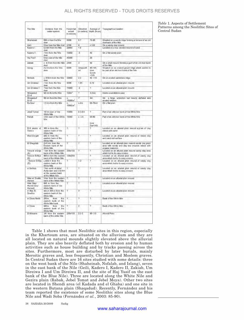
Table 1 shows that most Neolithic sites in this region, especially in the Khartoum area, are situated on the alluvium and they are all located on natural mounds slightly elevated above the alluvial plain. They are also heavily deflated both by erosion and by human activities such as house building and by tracks passing across the sites. Furthermore, most are disturbed by later burials, mainly Meroitic graves and, less frequently, Christian and Moslem graves. In Central Sudan there are 16 sites studied with some details: three on the west bank of the Nile (Shaheinab, Nofalab, and Islang), seven in the east bank of the Nile (Geili, Kadero I, Kadero II, Zakiab, Um Direiwa I and Um Direiwa II, and the site of Haj Yusif on the east bank of the Blue Nile). Three are located along the White Nile and Gezira plain (Rabak, Jebel Tomat and Jebel Moya). Other two sites are located in Shendi area (el Kadada and el Ghaba) and one site in the western Butana plain (Shaqadud). Recently, Fernández and his team reported the existence of some Neolithic sites along the Blue Nile and Wadi Soba (Fernández et al., 2003: 85-90).
38 SAHARA 20/2009 Sadig
Table 1. Aspects of Settlement Patterns among the Neolithic Sites of Central Sudan
ALL RIGHTS RESERVED - TOUS DROITS RESERVES
www.saharajournal.com
The sites are hereunder briefly mentioned according to region:
1. Khartoum areaFirst: West bank of the Main Nile:
a. Shaheinab The site is situated on an old riverbank on the west bank of the Nile c. 30 miles north of Omdurman. It consists of a low mound, about 200 meters long and more than 30 meters wide, about half a mile west of the modern river bank. The Shaheinab site was the first Neolithic settlement to be excavated in the Khartoum area and has showed evidence of a food-producing economy (Arkell, 1953).
b. Nofalab Nofalab site is situated on a gravel terrace on the west bank of the Nile 23 km north of Omdurman. The settlement is located c. 650 meters west of the present channel and covers an area of c. 180 x 170 meters (Magid, 1982: 9).
c. Islang The site is situated along the gravel ridge near a permanent source of water, at a distance of about 25.5 km north of Omdurman. The topography of the site is the same as that of Nofalab. It covers an area of c. 70 x 60 meters. Thus, it is obvious that the Nofalab site is larger than Islang site. The depth of the cultural debris in the undisturbed squares varies between 0.40 m and 1 m, and only one trench reached a depth of 1.05 m.
d. Jebel Umm Marrahi Crawford describes 2 enclosures on this hilltop, one showing considerable Neolithic occupation. The better preserved rough stone fort measures some 90 sq. m, with bastions. Crawford thought the sherds were mainly Meroitic or earlier (Crawford 1953: 25-6).
Second: East bank of the Main Nile:
a. Geili The site is situated about 2 km of the eastern bank of the Nile and 47 km north of Khartoum. It occupies an area of c. 150x180m (2700 m2) on a sandy clay mound. The mound rises to about 4 meters above the surrounding plain. The stratigraphy of the site is complex, testifying to the fact that the site was exploited for a long period, both as a settlement and as a cemetery. Intervals must have separated the periods of its use, so the burials in the sites had often been destroyed when new human groups came to the site (Caneva, 1984: 354-355).
b. Kadero IKadero I is located on a low, eroded mound of sand of about 18 km to the north of the confluence of the white and blue Niles and 6.5 km to the east of the channel of the main Nile (Krzyżaniak, 1984: 309). The size of the site is c. 30 000 square meters and its occupation deposits rises 1.8m deep in some places. A contemporary cemetery of 100s graves is associated with the settlement.
c. Kadero II This site is situated some 600 m to south east of Kadero I and extends for about 10000 square meters. The site is slightly elevated on a natural mound not more than 50 cm above the surrounding plain. Haaland, who surveyed and tested the site, considered it to be too eroded to be worth a large-scale excavation (Haaland, 1987: 230: 41f, 188).
A visit to the site in 1989 by Krzyżaniak revealed that Early Neolithic graves occurred in the part of the site being destroyed by an intensive quarrying for construction material. The graves were furnished with Early Neolithic pots typical also of the settlement and funerary pottery of Kadero 1 (Krzyżaniak, 1992: 244).
d. El ZakiabThe settlement of El Zakiab site is located c. 17 km north of Khartoum-North, on the eastern bank of the Nile and c. 3 km from the main course of the river. It is situated on a small mound which seems to be part of an old river bank of the Nile. The mound rises to a maximum 1.4 meter above the surrounding fossil flood plain. The extent of the site is c. 2000
SAHARA 20/2009 Sadig 39
ALL RIGHTS RESERVED - TOUS DROITS RESERVES
www.saharajournal.com
square meters of which 100 square meters were excavated (Tigani el Mahi, 1982:18f; Haaland, 1987: 26f).
e. Um Direiwa IUm Direiwa I site is located on the alluvial plain about 7 km east of the present bank of the Nile at a distance of about 13 km north of Khartoum (Tigani el Mahi, 1982: 20). The extent of the site is c. 90 meters in an east-west direction and c. 100 meters in a north-south direction. Several parts of the site were destroyed by the lorry traffic as well as by the activity of the local people who have taken the soil for building purposes (Tigani el Mahi, 1982: 20).
f. Um Direiwa II Um Direiwa II is situated about 3 km south east of Um Direiwa 1 and at the same distance from the Nile: i.e. c.7 km. It is located on the alluvial plain. The site is very deflated, and there is very little more than surface debris left (Haaland, 1987: 44).
Third: West Bank of the White Nile:
a. Salha Area: The El Salha Archaeological Project has been the subject of archaeological and geomorphological reconnaissance and excavation in Central Sudan by the Is.I.A.O. (Istituto Italiano per l’Africa e l’Oriente) since the autumn of 2000. The project located 160 archaeological sites (settlements and graveyards) ranging from the Lower Palaeolithic to the Early Islamic period (Usai & Salvatori, 2002). Of particular interest are the many Mesolithic and Neolithic sites, which are often larger than 10 ha in size, located both along the Nile and in the interior along the edges of an Early and Middle Holocene lagoon or lake-like basin. This wide lagoon reached, at its maximum extension, in the Early Holocene, the slopes of the Gebel Baroka, 30 km to the west the Nile (Cremaschi et al., 2006).
Settlements of the Neolithic period, like 10-X-3 and 10-X-4, were found along the Nile bank, while only quartzite lithic workshops were located in the Jebel Baroka area (e.g. site 10-U-11A and B, 10-U-19) (Usai and Salvatori, 2002). Neolithic sherds were recorder in site 10-U-3 which was built on top of a natural mound 2 - 3m in height, 10-X-8 and in el-Ushara site (10-S-4).
2. White NileRabak area:The site of Rabak is located 235 km of Khartoum along the White Nile. The settlement was excavated in Jan/Feb 1983 (Haaland, 1987: 45f). The site is located c. 3 km from the present flow of the river, and is elevated c. 3.5 m above the surrounding flood plain. The surface material is scattered over large area c. 200x80 meters. The cultural deposits were 60-80 cm deep.
3. Blue Nile and Gezira a. Jebel Moya The famous Sir Henry Wellcome excavated the Jebel Moya site, located c. 40 km east of Rabak site, in 1910-14 (Addison, 1949). Part of this site is contemporaneous with the later phase of Rabak (Haaland, 1987: 35, 46). Lithic artifacts recovered are the same type found on the Khartoum Neolithic sites, except that gouges are lacking.
b. Jebel Tomat The site of Jebel Tomat is situated some 50 km north east of Rabak town, and c. 10 km east of the White Nile at Esh-Shawal village (Magid, 1988: 49). The cultural deposit is rich, in some parts it is 1.26 cm deep but in average it is 0.5-0.6 cm deep in the excavated trenches.
c. Qoz Kabaro-2 The site is situated near of the village of Qoz Kabaro at both sides of the asphalted road that crosses the Gezira from East to West in this area. It contains mixed materials from different periods, from late Neolithic to Christian period, but the majority belong to the Late Neolithic (Fernández et al., 2003).
40 SAHARA 20/2009 Sadig
ALL RIGHTS RESERVED - TOUS DROITS RESERVES
www.saharajournal.com

SAHARA 20/2009 Sadig 41
d. Qoz Bakhit Situated about one km east from the previous site, near a small village and small tent camp of northern immigrants called Qoz Bakhit. The Qoz Bakhit site is c. 200 x 200 m in extension of surface artifacts dispersion. Several stone rings were seen but not retouched lithic tools were found (Fernández et al., 2003).
e.Wad Sheneina Near the village of Qoz Wad Sheneina. Over an elongated kôm that clearly rises around 2 meters over the flat Gezira plain, about 200 m long (in a NNE-SSW direction) and 50/60 m wide, there is a prehistoric site in the central and northern parts, with some Islamic remains at the southern end. Almost all the surface was covered with Pila and Limicolaria shells. This elevated area was occupied for a long period of time covering different cultural periods, since the pottery sherds belong to the Mesolithic, Late Neolithic, Meroitic (?), Christian and Islamic times. Also a lot of human bones were conspicuous on the surface (Fernández et al., 2003).
f. Bashaqra GharbNear the village of Bashaqra Gharb, on the road from Medani to Khartoum. The site extends only over a small kôm of around 20 x 20 m. The site contains both Early and late Neolithic materials (Fernández et al., 2003).
4. West of the Blue Nile and Hinterlanda. Haj Yusif This site is located about 8 km south east of Khartoum-North on the Blue Nile, in the area administratively known as Haj Yusif New Extension and about 4 km east of the Blue River (Fernández et al., 1989: 261). The site was discovered by A.J. Arkell in 1942 (Arkell, 1953: 108, Fig. 57), and excavated by the Spanish team in January 1989 (Fernández et al., 1989). The distribution of Neolithic sherds covers 300 X 150 meters. Due to water and wind erosion, and to later activities in Meroitic and Christian times, the Neolithic sherds and lithic implement had spread beyond their original distribution. The Neolithic strata were only 10-20 cm in thickness.
b. Hatab The site is located north-east of Khartoum, on the higher gravel plateau to the east of the alluvial plain. The archaeological material found on this site consists of few flakes of quartz, quartzite and volcanic tuff. The only tool found was a convex scraper. Otherwise no pottery or organic material which could have been used to date the site was left (Haaland, 1987: 44).
c. Sheikh el Amin The site is located on the south bank of the Wadi Soba course, about 1.8 km north of the village of Sheikh el Amin Balla, whose gubbas can be seen from the place. It is formed by eight kôms made of archaeological debris that are elevated between 1 and 1.8 m over the surrounding plain. The surface distribution of archaeological artifacts extends over an area of roughly 250 x 240 m. A freshwater mollusk (bivalve) shell from level 3B in square B-5 was radiocarbon dated in the laboratory of the University of Uppsala, using AMS method, yielding a date of 4590 ± 45 BP (Ua-20415) (see Fernández et al., 2003: table 2).
d. Soba-1 Scattered sherds in an area of about 20 x 30 m, made of two fabrics, with and without mineral temper. The first type is decorated with rocker impressions and wavy line; the second is decorated with incised triangles and comb impressed lines (Late Neolithic) (Menéndez et al., 1994: Fig. 3: 16- 27). Some fragmented grinders, one tapering cylindrical rubber and two flakes in sandstone were also collected.
e. Soba-2 Mesolithic / Late Neolithic. Scattered sherds in about 20 x 20 m, as in the previous site. Mesolithic sherds include dotted wavy line and rocker (highly eroded); late Neolithic sherds have incised triangles and impressed-incised combined decoration (Fernández et al., 2003).
ALL RIGHTS RESERVED - TOUS DROITS RESERVES
www.saharajournal.com

42 SAHARA 20/2009 Sadig
f. Rabob Situated near the village of Rabob. The surface remains extended over an area of about 600 x 500 m, with 8 small elevations divided by shallow erosion gullies. The sediments are part of an old terrace of Lower Proterozoic age with metamorphic material, around 1 meter high over the surrounding flat acacia and shrub areas, these being small lateral branches of Wadi Rabob. On the surface there were plenty of flakes, blades and broken white quartz pebbles, but the percentage of retouched tools was lower than it is usual in Mesolithic and even Neolithic sites. A shell sample from the test-pit B was radiocarbon analyzed (using the AMS technique) and produced a date of 4670 ± 50 BP (Ua-19741, Uppsala laboratory) (Fernández et al., 2003).
g. Bir el Lahamda Situated 40km from the main river. It is a very big site (500 x 300 m) of the Shaheinab phase. Unfortunately, this important site (an Early Neolithic settlement) could not be more intensively investigated (Fernández et al., 2003).
h. Wad el Amin The site is located over an ancient terrace and near a hafir and a modern Muslim cemetery. It consists of a dense concentration of Neolithic surface remains extending over an area of about 70 x 110 m (Fernández et al., 2003).
i. Jebel Qeili The site is consists mainly of a fine Meroitic inscription carved into a rock face. Other reports mention possible Late Neolithic sherds near the hill (Fernández et al., 2003).
j. Gereif West Geus records a Neolithic cemetery here as well as some post-Meroitic finds (Geus, 1984a: 13).
5. Sites between Atbara and Khartoum
a. Atbara-Shendi RoadAlong the Atbara-Shendi road, an archaeological survey and test excavations were carried out by the Sudan Archaeological Research Society (SARS). 15 sites were located (SARS 113.3, 138.2, 150.5, 152.6, 153.1, 153.2, 154.3, 155.1, 138.3, 147.1, 152.1, 154.1, 165.1, 222.1 and 231.1). The first eight sites were attributed as 3rd millennium B.C. sites and dated from the finds at Shaqadud and compared to material dating from the so-called “Pre-Kerma period” (before c. 2500 B.C.). The rest were attributed to earlier Mesolithic/Neolithic era (Mallinson et al., 1996: 1-6).
b. al Kadada The site lies on the right bank of the Nile, some 200 km north of Khartoum, in an area where the river flows from west to east. The site covers an area of about 800 m from east to west. Most of the ancient remains are found on the terraces, which are the highest features of the site, and in the area situated between them to the south, in the bed of a fossil khor (Geus, 1984a: 8).
c. el Ghaba El Ghaba site is situated east of the village of el Ghaba and south of al Kadada. A large area covered with fragments of pottery, chipped tools and animal bones indicating the presence of a Neolithic settlement. Many graves have been recorded. A few graves of historic times have also been found in the mound, where they destroyed parts of earlier Neolithic ones (Geus, 1984a).
d. Qoz Burra A large mound, c. 300mx200m shows quantities of Neolithic remains, but some Meroitic sherds have also been found here. The ruins on the mound are possibly recent and it is unclear whether this represents a Meroitic settlement (Ahmed, 1984: 28).
6. Butana: ShaqadudThe site of Shaqadud lies about 50 km east of the Nile from the village
ALL RIGHTS RESERVED - TOUS DROITS RESERVES
www.saharajournal.com

SAHARA 20/2009 Sadig 43
of Wad Banaga and about 13 km from the Meroitic monuments at Naq’a in the western end of the Butana. Shaqadud is a complex of sites rather than a single locality. The main site, S1, comprises two localities: S1-A, which is a large cave at the back of a canyon, and S1-B, a midden located in front of the cave. There are also numbers of small surface sites on top of the surrounding plateau and along its slopes. The deposits in the cave have a depth of 3.35 m (Mohammed-Ali, 1987: 129-130).
7. Desert west of the main Nile (Wadi Al Muqadam Finds)Certain sherds from site 115.1 are dated the later Neolithic period (Fuller & Smith, 1998). No other information is available.
8. New discoveries First: Sites between Kalakla and Jebel Awlia13 sites were discovered in the area situated between El Kalakla and Jebel Awlia (Eisa, 1997), but were either not excavated or not fully published. From the primary surveys it is observed that most of these sites were essentially of the Neolithic period accompanied by material that could be traced back to the Mesolithic and included only one grave used in different times after the Neolithic (properly Meroitic and post-Meroitic) (Sadig, 1999). 12 of these sites were surveyed during the preliminary survey of 1997, and the author, as a requirement of the MA and the Ph.D. thesis, revisited all of them. The study of the material from these sites (Sadig, 1999, 2004) proved the existence of a considerable amount of material in the study area dating from the Mesolithic to the Meroitic and post-Meroitic periods. These sites were affected by different natural and human activities during the last fifty years. These sites differ in some aspects; some are represented by the clear concentration of archaeological remains and the evident scarcity of these remains in the others, due to natural and human activities. Most of the sites represent settlement areas.
a. El Kalakla el Teria’a: c.15°27/32°28
Situated about 2 km from the eastern bank of the White Nile to the south of El Kalakla Al-Quba area. It is a plain of clay mixed with sand covered with decorated and undecorated potsherds. Most of these potsherds are rough and it is not possible from their shape and decoration to determine the age they belong to, but they represent a mixture of potsherds that belong to the Neolithic and Mesolithic periods in Central Sudan based on some typical potsherds found there.
In addition to all the above mentioned, there are few lithics and bones. The bad condition of the site may be due to the human factors accompanied by such natural factors as erosion. No graves were observed during the survey.
b. Wad Ela’gali c.15°26/32°27 It is a small site situated to the south of El Kalakla El Teria’a about 500 m from the eastern bank of the White Nile. Lithics, potsherds, bones and shell are scattered in the mixed clay and sand soil surface of the site. The bad condition of the site and the scarcity of the archaeological materials reflect the human and natural factors that affected the site. For all these reasons it was not easy to determine the exact extent of the site and the period it belongs to, although most of the small potsherds have similar features to the Neolithic of Khartoum area.
c. El Shegelab 15°23.524/32°30.988This site is situated about 25 km from Khartoum and 1 km from the Eastern bank of the White Nile and about 250 m to the west of Khartoum-Jebel Awlia railway. It is a sandy clay plain area with sandy and clay low mounds mixed with organic materials, especially in the southern part which today forms a part of a newly-built village.
The site is covered with a great quantity of potsherds. Some of them are not polished but most of them are decorated with rocker zigzag lines and impressed dots.
ALL RIGHTS RESERVED - TOUS DROITS RESERVES
www.saharajournal.com

After three years from the preliminary surveys the researcher revisited the site and found that the earlier layers of the site, which appeared from a recent well, were back to the Mesolithic period. This was indicated by the great quantities of the wavy-line decorated potsherds and other material that belong to this period. The lithic materials found on the site contain lithics made from quartz, such as crescents, burins, and scrapers beside many grinding implements made from sandstone. This site is covered on most parts with animal bones and shells. Although this site has similar features to the Neolithic of the Khartoum area, we observed that there is a complete absence of some tools such as gouges, polished axes.
d. Teria’at el Bija (A): 15°20 007/32°30 767It is situated about 30 km from Khartoum and 2 km from the eastern bank of the White Nile not far from Khartoum-Jebel Awlia railway. The site is very large and extends to about 200x150 m, which makes it one of the largest discovered sites in the survey area. The site exists in a sandy clay area which led to its easy erosion; agricultural and rehabilitation activities have caused great damage to the site. Potsherds, lithics, grinding implements, shells and other organic and inorganic materials are scattered in a great area of the site. The site contains potsherds and lithic materials, except the polished axes and gouges that are similar to those found in Shaheinab site.
Teria’at El Bija (B): c.15°20 646/32°30 923The site situated 30 km from Khartoum and 200 m to the west of Teria’at El Bija (A) site. They are divided by a khor that runs to the west towards the White Nile. The area of the site is about 120x200 m. It is covered with large quantities of decorated and undecorated potsherds. Some of these potsherds are similar to those found in Teria’at El Bija (A) site, so it might be an extension of it, especially since they are very near to each other. There are also lithic materials, grinding implements and animal bones. There are no contemporary cemeteries associated with the site. The site is prone to erosion because of the floods and human activities.
Teria’at El Bija (C): c.15°20 624/32°30 977 The site is situated 32 km from Khartoum, few meters from the eastern bank of the White Nile. It is a mound raised 1-2 m of the surrounding alluvial plain that is cut by three khors which run to the west towards the White Nile.
Potsherds with general features of the Neolithic decorations are scattered on the site. They are the most common archaeological material on it. The lithic materials and grinders are not common. There are also few animal bones and shells.
What is very important here is that these three sites (Teria’at El Bija A, B and C) have similar archaeological and topographical features. They might be one site that separated into three sites but there is no exact evidence, in this part of the study, which support this hypothesis.
e. el Selikab: c.15°17 457/32°32 253 This site is situated to the north of Selikab village, about 34 km south of Khartoum, 7 km north of Jebel Awlia dam and 1 km of the eastern bank of the White Nile. It is a small sandy mound covered with different archaeological materials that contain some potsherds and large quantities of lithic materials. But the former had been affected by the natural factors that change its shape and sharp edges. In addition, there are gray fossilized animal bones, and shells.
f. Hilat el Sheikh Hamed: c.15°15 271/32°31 311 This site is situated 36 km south of Khartoum and 1.5 km from the eastern bank of the White Nile. It is a low mound covered with different decorated and undecorated potsherds, badly finished lithics made from Nile pebbles, and grinding implements.
g. Hilat Wad Hamid (Qoz Hamed): c.15°15 646/32°30 375Situated 38 km from Khartoum, and 500 m from the eastern bank of the White Nile. It is a low mound covered with different sizes of decorated and unpolished potsherds. Different types of flaked stone materials were found in the site, most of them are scrapers and other different flakes.
Crescents and borers are very few. Cylindrical grinders and different
44 SAHARA 20/2009 Sadig
ALL RIGHTS RESERVED - TOUS DROITS RESERVES
www.saharajournal.com

SAHARA 20/2009 Sadig 45
tapering cylindrical rubbers are found in the site. Fossil bones of big animals, teeth, besides fossil wood pieces are observed on the surface. It is very clear from the surface remains, especially the potsherds, that this site is similar to the other Neolithic sites in the area.
h. el Bija El Dewihia 15°13.567/32°29.73 This site is situated to the southern east of Jebel Awlia, about 200 m from the eastern bank of the White Nile. It is a big mound (3 m height above the surrounding surface) divided by a small inlet that runs towards the west. There is a recent Islamic cemetery covering most of the site surface. There is also a 298 m longitudinal division in the eastern part of the site (from the north to the south), that resulted from the erosion and the Nile water movements. This helps a lot in identifying the site layers. The clay soil surface graded from the east to the west to the highest point in the longitudinal division.
The site is considered as the richest among the sites surveyed in this part of the White Nile because it is composed of diversely decorated potsherds, lithic materials and has the richest layers. The potsherds have also different types of decorations characteristic of the Neolithic in Central Sudan, such as the impressed dots, rockers and rippled decorations. Few wavy-line decorated potsherds are found in the site, neither in the surface nor the layers in the western part of the site. There are also some undecorated potsherds characterized by a reddish colour on the surface or a polished brown colour with different impressed circles near the rims. There are a lot of lithic materials on the surface and in the layers in the western part. Most of them are scrapers and polished stone axes of which similar types were found in Shaheinab and some of the Neolithic sites of Khartoum. There are also few blades, crescents and different flakes. Grinders are many, but the common types are very few. Because this site is very close to the Nile, it is very natural that there are many types of shells although some of them were intrusive especially since this site is on the water level during the flood season. In addition, there are different types of animal bones but they are greatly broken. During the survey no contemporary cemeteries were observed in spite of the existence of a single grave surrounded by rocks found among the Islamic graves.
From the above-mentioned information and after the precise study of the archaeological materials we can say that this site can be considered as a model site of the Neolithic in this area. It may be dated to the late period of the Neolithic, perhaps occupied for successive periods. Specifically, there are different potsherds similar to Meroitic and Post-Meroitic periods which implies continuity in the use of the site. Moreover, this site is considered as the most threatened from the White Nile water and the recent Islamic cemetery.
i. el Dirwa North: c.15°15/32°30 This site is situated few meters south of El Dewihia site, near the White Nile bank. Generally, the site is of small size, with few archaeological remains. Although the potsherds are very few, the samples collected are characterized by very fine decorations based mainly on dots forming distinctive geometrical shapes. There are also wavy line decorated potsherds. The most distinguished piece is a potsherd decorated with a figure of a mammal with the front feet, the abdomen, the back and part of its back foot. Incised rocker zigzag lines were used to decorate the surface of the animal.
j. el Dirwa : c.15°15.646/32°30.375 This site is situated to the south of el Dirwa North, about 500 m from the eastern bank of the White Nile. It is a mound 2 m high above the surrounding alluvial plain, covered with various archaeological remains: potsherds, lithics and bones. The decoration of potsherds is characterized by horizontal and vertical impressed dots, rocker dotted zigzag and incised lines besides some geometrical decoration. The amount of potsherds increases in the eastern part. There are also different types of lithics, such as flakes and polished stone axes. This site also consists of bones, especially of big animals. A human lower jaw with some teeth was found on the surface, implying the existence of graves1.
k. El Masarra El Masarra is one of the scattered villages along the east bank of the White Nile, about 37 km south of Khartoum. The site is located about
1 A Neolithic site and Merotic graves were discovered just south of this site during the 2002 season of the White Nile survey. Students from the dept. of Archaeology, University of Khartoum excavated some of these graves in summer 2002.
ALL RIGHTS RESERVED - TOUS DROITS RESERVES
www.saharajournal.com
46 SAHARA 20/2009 Sadig
270 m west of the Khartoum-Jebel Awlia highway. It is a low mound covering an area about 200x150 m and up to 2.5-3 m high above the surrounding area. Almost the whole site is covered with artifacts, human and animal bones, shells and other recent artifacts. The site is surrounded by a modern enclosure about 100x100 m wide called Al Shafakhana (Health Center).
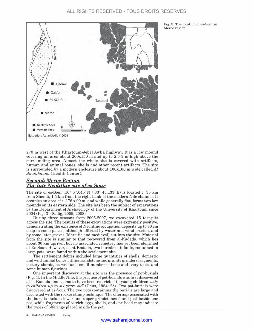
Second: Meroe RegionThe late Neolithic site of es-Sour The site of es-Sour (16° 57.045’ N / 33° 43.133’ E) is located c. 35 km from Shendi, 1.5 km from the right bank of the modern Nile channel. It occupies an area of c. 176 x 90 m, and while generally flat, forms two low mounds on its eastern side. The site has been the subject of excavations by the Department of Archaeology of the University of Khartoum since 2004 (Fig. 3) (Sadig, 2005, 2008).
During three seasons from 2005-2007, we excavated 15 test-pits across the site. The results of these excavations were extremely positive, demonstrating the existence of Neolithic occupation deposits up to 80 cm deep in some places, although affected by water and wind erosion, and by some later graves (Meroitic and medieval) cut into the site. Material from the site is similar to that recovered from al-Kadada, which lies about 30 km upriver, but no associated cemetery has yet been identified at Es-Sour. However, as at Kadada, two burials of infants, contained in large pots, were found within the settlement site.
The settlement debris included large quantities of shells, domestic and wild animal bones, lithics, sandstone and granite grinders fragments, pottery sherds, as well as a small number of bone and ivory tools, and some human figurines.
One important discovery at the site was the presence of pot-burials (Fig. 4). In the Middle Nile, the practice of pot-burials was first discovered at el-Kadada and seems to have been restricted to young children ‘only to children up to six years old’ (Geus, 1984: 28). Two pot-burials were discovered at es-Sour. The two pots containing the burials are large and decorated with the rocker stamp technique. The offerings associated with the burials include lower and upper grindstones found just beside one pot, while fragments of ostrich eggs, shells, and one bead may indicate the types of offerings placed inside the pot.
Fig. 3. The location of es-Sour in Meroe region.
ALL RIGHTS RESERVED - TOUS DROITS RESERVES
www.saharajournal.com

The majority of lithic artefacts are finished scrapers, backed tools, borers, burins, crescents and retouched and un-retouched blades. One interesting find was a small rhyolite artefact with a characteristic shape and two small hollows on both faces. Its function remains uncertain, although the shape suggests that it may have been a fine polishing/grinding tool or palette. The example from es-Sour is very similar to specimens found at el-Kadada (Geus, 1984: 69), Eastern Butana and near Kassala (Marks et al., 1986: 47). The ground-stone sample recovered from the 2006 excavations is large. This includes disc grinders and pounders.
The main characteristic of the pottery sherds is a hard texture, good firing and polished surfaces. The decoration generally covers most of the surface, extending to near the rim or to the rim itself. The rims are simple in shape but vessel shapes at the site include a range of mainly open-mouthed vessels.
Beads made of egg-shell, bones and carnelian, lip-plugs and one ivory artefact were recorded during the course of the excavation. A single shell object used as a comb for decorating pottery, was also recorded. Other typical Neolithic bone artefacts such as harpoons and gouges were not found.
Other finds of potential importance were 6 fragments of human figurines (Fig. 5). Two of them look very similar to examples found at el-Kadada (Geus, 1984: 22). Unfortunately, the upper and lower parts of the figurines are missing. The purpose of these pottery figurines remains unclear although it is often assumed that they have a religious significance.
Faunal remains consisted of bones of wild and domesticated animals including domesticated cattle, giraffe, buffalo as well as numerous remains of shells. This identification was carried out by Prof. Achilles Gautier who based his identifications on photographs of the remains.
The most distinctive features of the es-Sour material are the high index of flakes, the decorative styles of the pottery, specific types of lithic artefacts and pot-burials, as well as t the presence of carnelian beads and human figurines. A freshwater mollusc (Nile oyster) shells from levels between 20 and 50cm in squares C6, B13 and F7 were radiocarbon dated in the Radiocarbon Dating Laboratory of University of Waikato,
Fig. 4. Pot-burial from es-Sour.
SAHARA 20/2009 Sadig 47
ALL RIGHTS RESERVED - TOUS DROITS RESERVES
www.saharajournal.com

New Zealand, yielding the following dates:
Wk23036: 5296±48BP (Oxal calibrated: 68.2%: 4230BC-4190BCand 4180BC-4040BC)
Wk23037: 5330±54BP (Oxcal calibrated: 68.2%: 4240BC-4050BC)
Wk23038: 5180±48BP (Oxcal calibrated: 68.2%: 4045BC-3955BC)
These dates place the site in the middle Neolithic of central Sudan and perhaps slightly earlier than the oldest dates from Kadada (GIF-5770: 5170±110 BP) (Geus, 1981).
DiscussionThe following generalizations about the settlement patterns of the Central Sudan Neolithic sites may be made:
1. Most known sites are quite large and the occupation layers are of considerable depth, although stratified deposits seem to be lacking in some sites (Fig. 6). Cemeteries are sometimes associated.
2. The sites on the west bank in Khartoum area and between the White and Blue Niles besides the sites in Shendi area are today generally close to the water and they were even closer at the time of occupation.
3. The sites on the east bank in Khartoum area lie a considerable distance from the present Nile. The location suggests that the Nile was covering part of the surrounding plain, at least seasonally, perhaps with small lakes and swamps.
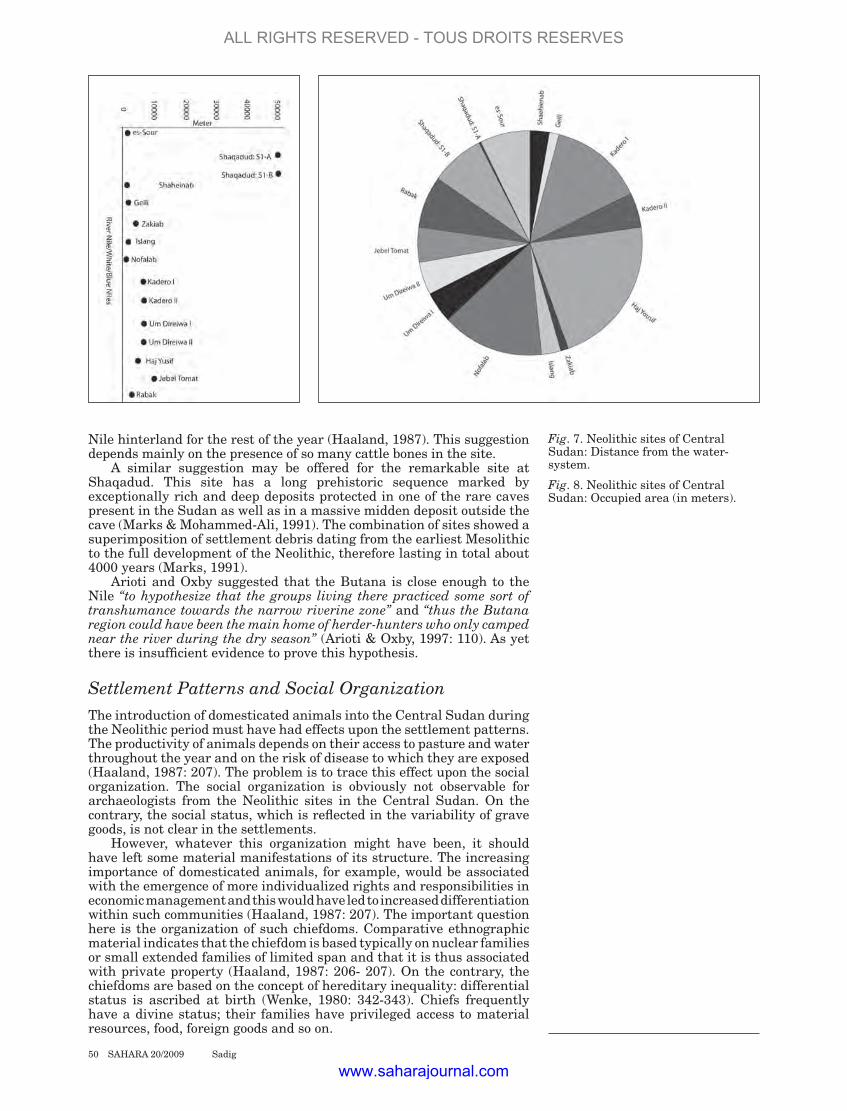
Interpretation of these patterns were generally based on seasonal movement. Four of the sites on the east bank (Kadero I and II, Um Direiwa I and II) shared certain features. They are large, occupying areas of between 10000 m and 45000 m, and they are situated, on average, about 7 km from the present river (Fig. 7 and 8). The sites were rich in pottery, grinding implements and lithic materials and had burials associated with them.
On the basis of the distribution of these sites and their cultural manifestations, it was postulated that they reflected a settlement pattern related to seasonally specific activities (Haaland, 1987). The four large sites were seen as permanent base camps where emphasis was placed upon the exploitation of plants, sorghum cultivation, and the manufacturing of pottery.
A small site (Zakiab) was interpreted as a dry season camp where herding and fishing were practiced. It was temporarily occupied and also seen as a place where lithic artifacts were manufactured.
Fig. 5. Fragments of pottery human figurines from es-Sour.
48 SAHARA 20/2009 Sadig
ALL RIGHTS RESERVED - TOUS DROITS RESERVES
www.saharajournal.com

The model proposed that a large community occupied a base camp when conditions were favorable for cultivation. During the dry season the inhabitants of each base camp would split into smaller bands and occupy fishing and herding camps along the Nile where conditions would be optimal for these activities. After the rains, equivalent herding camps would be set up in the grasslands of the Butana farther to the east.
Mohammed-Ali and Magid attempted to test this model within the same general area but with sites found on the west bank of the Nile. They showed that the sites on the west bank (Nofalab and Islang) are close to the river and “the Settlement pattern on the west bank does not suggest occupation back from the river as the case of the east bank” (Mohammed-Ali & Magid, 1988: 66). They also suggested that the topographical differences between the two banks must have affected local adaptation. In other words the flat alluvial clays of the east bank with their Nile-fed swamps and ponds would allow cultivation to be practiced and would support a rich pasture with a thick cover of vegetation and shrubs.
On the other hand, the eroded sandstone and pebble conglomerates of the west bank would not permit agriculture, and their stony surfaces support relatively little grass even after the rainy season (Mohammed-Ali & Magid, 1988: 66). They suggested a reversed pattern to that proposed by Haaland. Their model assumes that, since the large sites are located close to the river, these sites might have served as base camps, densely populated during the dry season. When conditions improved in the hinterlands, during the rainy season, part of the population might have split into small groups and occupied smaller sites in those areas.
The distribution of raw materials does not seem likely to be a major factor in settlement location. Sources of high quality stone for tool making are very limited in most of the Middle Nile region. The majority of lithic tools were made on Nile pebbles, quartz pebbles, and sandstone, which are commonly available. Most sites have shown no traces of exotic or imported material. Exceptionally in the Khartoum region, small quantities of rhyolite from the Sixth Cataract are found, and more rarely exotic amazonite, from an unknown source (thought by Arkell to come from Tibesti) (Arkell, 1953: 4). The two models of seasonal patterns, though based on limited data, are plausible, but the evidence from the region has failed to provide conclusive proof and some problems remain, notably in relation to the possible role and significance of agriculture in subsistence strategies. Another significant problem is the lack of smaller (and more ephemeral) inland sites which could relate to shorter-term seasonal activities. If these were existed, then “it might be indicated that two quite different settlement systems existed on the opposite banks of the Nile River during the Khartoum Neolithic” (Arkell, 1953: 67).
A more general problem remains concerning the identification of the most impressive large and artifact-rich sites as permanent settlements, with a considerable static population. Some of these sites may have been occupied over a long period of time, which could explain the high density of lithic materials, pottery and other debris and, in some cases, with the grave scattered in and surrounding the sites. However, it is important to recognize that there is no evidence for dwellings or other permanent structures found in association with any of the Neolithic sites. It is likely that such dwellings were made of perishable materials which will have left relatively few, or no, traces, like those made by the present inhabitants of the region (Arkell, 1953).
It is also clear that the sites have suffered considerable erosion and deflation, which will have removed many more ephemeral features. However, the basis for assuming that permanent settlements or what can be called ‘proto-villages’ existed during this period remains far from clear. If we accept that pastoralism was becoming an increasingly important feature of Neolithic way of life, the role of such permanent centers remains unclear. The large quantities of pottery, lithic and food debris recovered from the sites are certainly not what we might expect from relatively mobile pastoral communities. Arioti and Oxby have drawn attention to special activities happened on such large sites (Arioti & Oxby, 1997). They partly accept Haaland’s suggestion that rather than a permanent settlement, Kadero might be interpreted as a special meeting place or a herders’ gathering place used for collective ceremonies and feasts with ritual killing of animals. Those people would have lived scattered in the
Fig. 6. Neolithic sites of Central Sudan: depth of archaeological material.
SAHARA 20/2009 Sadig 49
ALL RIGHTS RESERVED - TOUS DROITS RESERVES
www.saharajournal.com
Nile hinterland for the rest of the year (Haaland, 1987). This suggestion depends mainly on the presence of so many cattle bones in the site.
A similar suggestion may be offered for the remarkable site at Shaqadud. This site has a long prehistoric sequence marked by exceptionally rich and deep deposits protected in one of the rare caves present in the Sudan as well as in a massive midden deposit outside the cave (Marks & Mohammed-Ali, 1991). The combination of sites showed a superimposition of settlement debris dating from the earliest Mesolithic to the full development of the Neolithic, therefore lasting in total about 4000 years (Marks, 1991).
Arioti and Oxby suggested that the Butana is close enough to the Nile “to hypothesize that the groups living there practiced some sort of transhumance towards the narrow riverine zone” and “thus the Butana region could have been the main home of herder-hunters who only camped near the river during the dry season” (Arioti & Oxby, 1997: 110). As yet there is insufficient evidence to prove this hypothesis.
Settlement Patterns and Social Organization The introduction of domesticated animals into the Central Sudan during the Neolithic period must have had effects upon the settlement patterns. The productivity of animals depends on their access to pasture and water throughout the year and on the risk of disease to which they are exposed (Haaland, 1987: 207). The problem is to trace this effect upon the social organization. The social organization is obviously not observable for archaeologists from the Neolithic sites in the Central Sudan. On the contrary, the social status, which is reflected in the variability of grave goods, is not clear in the settlements.
However, whatever this organization might have been, it should have left some material manifestations of its structure. The increasing importance of domesticated animals, for example, would be associated with the emergence of more individualized rights and responsibilities in economic management and this would have led to increased differentiation within such communities (Haaland, 1987: 207). The important question here is the organization of such chiefdoms. Comparative ethnographic material indicates that the chiefdom is based typically on nuclear families or small extended families of limited span and that it is thus associated with private property (Haaland, 1987: 206- 207). On the contrary, the chiefdoms are based on the concept of hereditary inequality: differential status is ascribed at birth (Wenke, 1980: 342-343). Chiefs frequently have a divine status; their families have privileged access to material resources, food, foreign goods and so on.
Fig. 7. Neolithic sites of Central Sudan: Distance from the water-system.
Fig. 8. Neolithic sites of Central Sudan: Occupied area (in meters).
50 SAHARA 20/2009 Sadig
ALL RIGHTS RESERVED - TOUS DROITS RESERVES
www.saharajournal.com

Indeed, burial practices might reflect some relation to other aspects of human life such as economic practice or political power. Haaland suggested that among the people inhabiting sites between Sabaloka and Jebel Awlia “a greater complexity in cultural traditions evolved, probably involving stronger political organization” (Haaland, 1987: 223). It is difficult to understand the stability of the southern and northern limits of the distribution of this cultural tradition. One possibility is that the political organization of the people carrying all the manifestations at the Khartoum Neolithic tradition, required a certain surplus production which could not be realized outside the distribution area (Haaland, 1987: 223). It seems that, in spite of many excavated sites, the social organization of the people of the Neolithic in Central Sudan will be limited to burial information. The hypothetical social classes reflected in the graves were not observed in the settlements. However, presently available evidence seems to indicate that the burial grounds at el Kadada and Kadero I seem to illustrate well the process of the increasing concentration of goods and power by social “elite?” toward the end of the Neolithic.
It is clear that the social structure in the Central Sudan during the Neolithic period exhibited more or less inseparable economic and settlement patterns which are in turn witnessed by certain developmental stages from Early Neolithic until we reach the complex picture of the Late Neolithic. Although the degree of permanency varies from one site to another until its zenith at Kadero I and el Kadada, all the way through we still have mobile pattern which started to have regular schedule of the microenvironments in the later times.
Chronology
One of the most serious problems in studying the changes over the fourth millennium is to draw chronological parallels between sites and regions. A number of terms have been used to describe these phases, some of which are more confusing than enlightening.
We agreed that the terms “Shaheinab or Early Khartoum” should be retained only as terms for a cultural phenomenon. Because they are used both as terms for a time period and cultural phenomenon, it is ultimately confusing. We also agreed that “Khartoum Variant” is a poor name for the “Neolithic” of part of Lower Nubia. Firstly, Khartoum Variant chronology is based on generally similar features in the Early Khartoum Mesolithic rather than Shaheinab Neolithic, and there is no way to define increasingly fine distinctions in time as more data should permit. In part this is because the Khartoum Variant material is defined on the basis of a limited number of sites and is difficult to connect with Shaheinab sites, which are producing considerable samples under conditions of modern stratigraphic excavation. Moreover, the claim that there are ceramic affinities which link the Khartoum Variant with Arkell’s Mesolithic is unfounded because the characteristic features of the Khartoum pottery, wavy line and dotted wavy line, have no representation at the Khartoum Variant sites (Mohammed-Ali, 1982: 144).
We debated many different names for purely chronological terminol-ogy, but in the end accepted general terms like Early Khartoum and Sha-heinab. We used them to distinguish sites that prevailed during the Me-solithic and Neolithic periods. These terms should not be applied in all cases, since sites distinguished by local variations should not be forced into the general classificatory categories. The material culture of the Neolithic and Mesolithic sites suggests they belong to different chrono-logical periods. The absolute dates from different sites definitely prove this with certainty. Furthermore, when the Neolithic sites are compared it would appear that not all the sites are the same. They differ chrono-logically as well as in many different aspects of the material culture for every site. Some sites contain typical Shaheinab material, e.g. gouges, and others do not. For example, the site of Rabak is recognized as typi-cal Shaheinab site although it lacks gouges. Geili, with rhyolite gouges and incised ware corresponds to the Shaheinab assemblages and could be chronologically close to it. On the other hand, some are totally differ-ent from Shaheinab and reflect a greater degree of development (e.g. el Kadada). From this description it is clear that we could recognize three
SAHARA 20/2009 Sadig 51
ALL RIGHTS RESERVED - TOUS DROITS RESERVES
www.saharajournal.com

types of Neolithic “variants”. They share some Neolithic traits with the type site of Shaheinab but they also lack some of the main traits of that site:
1. Shaheinab type-site: sites contain typical Shaheinab material, especially the gouges (Geili, Nofalab and Kadero).
2. The second variant shares some traits with Shaheinab but lacks the gouges (Rabak, Jebel Tomat and Jebel Moya).
3. The third is found at sites like el Kadada, where the site is partly contemporary with the late period of other two assemblages but reflects a higher development in material culture than them (Es-Sour).
Many radiocarbon dates were obtained from the Neolithic sites in Central Sudan. Some of them are shown in Table 2 (see also Fig. 9). These dates indicate that the Neolithic in the Central Sudan ranges between 4915 B.C. and 2095 B.C. covering a period of at least 2820 years. Most of the sites flourished during the 5th millennium B.C., others extended till the 4th millennium B.C. while the site of Shaqadud extended till the first decades of the 3rd millennium B.C. From this list of the available dates it appears that:
1. The sites of Um Direiwa I and II, el Ghaba, Islang, Rabak, Shaheinab, and Kadero I and II belong to the 5th millennium and survived during the first part of the 4th millennium.
2. There are a few sites from Central Sudan such as that of Um Direiwa I and Rabak whose culture debris consists of remains ranging from the beginning of the Neolithic in the area (4915 to 4890 B.C.) to the latest phase for it (3245 to 3765 B.C.).
3. The site of Rabak provides the earliest dates of the Neolithic. It includes typical Shaheinab materials and therefore could be the earliest site known till now that shares similar materials with the Khartoum sites.
4. The two sites, el Kadada and Shaqadud cave, offer a different panorama, where their dates belong to the 4th and 3rd millennia BC. The fourth date of Shaqadud Cave sheds more light on the chronology of the Central Sudan since Shaqadud Cave is the only site that survived during the 3rd millennium. There are no sites in the Khartoum area that yielded a C14 date after 3765 B.C. There are a few dates from el Kadada in Shendi area and further south from Rabak and Jebel Tomat; they all fall in the period between 3245 to 3390 BC. There are also some surface sites discovered along the Begrawiya-Atbara road that contain some materials stylistically similar to the 3rd millennium pottery at Shaqadud (Mallinson et al., 1996). These sites need a detailed study but their existence might put them in as a possibility for future investigation of the cultural history of the Central Sudan. However, the time span of the Neolithic of all the sites situated along the Nile from Shendi to Rabak extends until the beginning of the 4th millennium B.C. From that time onward, there is an apparent chronological gap of some 2000 years until the beginning of the Meroitic Kingdom. Different theories and hypothesis have been suggested in an attempt to explain this gap. None of these seem to have come up with a comprehensive opinion (Mohammed-Ali, 1986; Sadig, 1999).
5. Some of the C14 dates from Shaqadud Cave seem to be contemporary with the Classic period of the A-Group culture in Nubia. According to Nordstrom, the latter is dated to 2705 BC (c. 4655 BP) (1972: 251). Moreover, the site SJE-277, which belongs to the Classic A-Group, is dated to 4630±120 BP (Hays, 1984: 216). This site, however, is contemporary with el Kadada and Shaqadud Cave. Moreover, some of the material found at el Kadada presents a number of affinities with the A-Group and C-Group cultures of Nubia (Geus, 1984b: 368). These includes frequent occurrence of circular or sub-circular grave shafts and of superimposed burials, large quantity of graves goods inside the shafts.
52 SAHARA 20/2009 Sadig
ALL RIGHTS RESERVED - TOUS DROITS RESERVES
www.saharajournal.com

Krzyżaniak suggests that the Neolithic period of the Central Sudan could be divided into two periods (Krzyżaniak, 1992: 243):
1. Early Neolithic: from 4900-3800 BC. 2. Late Neolithic: 3800-3000 BC.
This division indicates that the first “culture” survived during the most part of the 5th millennium and the first decades of the 4th millennium BC. This culture is generally called “Shaheinab” or “Khartoum Neolithic”. The second is the culture found in sites like el Kadada, Shaqadud Cave and others. Shaheinab culture lasted far longer than originally thought- at least 1000 and as much as 1100 years. This culture continued and increased through some sites like Kadero I. Throughout Central Sudan there was considerable variation in the durations of the Neolithic. The Shendi home land had more than one assemblage (Early Neolithic at Ghaba, Late Neolithic at el Kadada, and Post-Neolithic at Makbor). In Khartoum region the structure and chronological relations between different sites varied widely. Nevertheless, we hypothesize that the sites accommodated similar economic systems, typified by various modes of similar goods. Considerable variation existed in the time duration of every site. Chronologically, the western bank sites were very different from those on the eastern bank. Sites with almost exclusively early Neolithic style cultural material on western bank e.g., Shaheinab, Islang and Nofalab survive for about 860 years.
Table. 2. Available Radiocarbon Dates from Central Sudan.
SAHARA 20/2009 Sadig 53
ALL RIGHTS RESERVED - TOUS DROITS RESERVES
www.saharajournal.com

By contrast, in the eastern bank, surveys and excavations suggest that a long duration of occupation existed at sites like Kadero. The eastern bank sites extended for about 1000 years. There are no large differences in the two microenvironments, and the Neolithic life appears similar. The short duration of the western bank sites may be due to other reasons, always the limitation of archaeological research must be considered. The so-called Late Neolithic is applied to some sites that share similar material culture, graves, and subsistence economy. Some sites, namely Shaqadud Cave site, are related to this period although they exhibit exclusively local material culture and mode of life. Others, e.g. Kadero, include dates belonging to the Late Neolithic although they maintained and continued with no change throughout their existence. There is however sufficient evidence to show continuity in these sites, and to suggest that they represent a continuous cultural tradition. An unknown sequence of occupation can be traced through the 4th millennium B.C. This means that any attempt to divide the Neolithic period of the Central Sudan must include specific studies of the material culture and modes of life. Any division is not restricted to chronology but must be applicable to the whole cultural elements of every site.
Conclusion
The study of “settlement patterns” is a more difficult issue when we have so few sites in a wider area. Accordingly it is not clear whether the settlement patterns we see reflect the real situations that have existed. We only have very little data to discuss the possibility of “seasonal sites”. Normally, and in many cases, most such sites are just lithic scatters, some possibly for making tools. The question is, can we show that sites are different from each other by the materials
54 SAHARA 20/2009 Sadig
Fig. 9. Distribution of some Radiocarbon Dates available for the Neolithic of Central Sudan.
ALL RIGHTS RESERVED - TOUS DROITS RESERVES
www.saharajournal.com

AdAmson d.A., J.d. ClArk And m.A.J. WilliAms, 1974. Barbed Bone Points from Central Sudan and the Age of ‘Early Khartoum’ Tradi-tion. Nature, 249: 120-23.
AdAmson d.A., F. GAsse, F.A. street And m.A.J. WilliAms, 1980. Late Quaternary History of the Nile. Nature, 288: 50-55.
Addison F., 1949. Jebel Moya. Vol. 1. Oxford University Press.
Arioti m. And C. oxby, 1997. From Hunter-Fisher-Gathering to Herd-er-Hunter-Fisher-Gathering in Prehistoric Times (Saharo-Suda-nese Region). Nomadic People, Vol. 1: 98-119.
Arkell. A.J., 1949. Early Khartoum. An account of the excavation of an Early Occupation Site Carried out by the Sudan Government Antiq-uities Service in 1944-45. London: Oxford University Press.
Arkell. A.J., 1953. Shaheinab. An account of the excavation of a Neo-lithic occupation site carried out for the Sudan Antiquities Service in 1949-50. London: Oxford Uni-versity Press.
bAll J., 1939. Contribution to the Geography of Egypt. Cairo.
berry l., 1961. The Physical Histo-ry and Development of the White Nile. 18th Annual Report. Hydro-biology Res. Unit. University of Khartoum. Sudan.
berry l. And A.J. WhitemAn, 1968. The Nile in the Sudan. Geograph-ical Journal, 134: 1-37.
bronk rAmsey C., 2005. OxCal Pro-gram v 4.0.5. Oxford: Univer-sity of Oxford Radiocarbon Unit. http://www.rlaha.ox.ac.uk/oxcal/oxcal.htm
butzer k.W. And C.l. hAnsen, 1968. Desert and River in Nubia: Geo-morphology and Prehistoric En-vironments at the Aswan Reser-voir. Madison: University of Wis-consin Press.
butzer k.W. et al., 1972. Radiocar-bon Dating of East African Lake Levels. Science, 175: 1069-1076.
CAnevA i., 1983. Pottery Using Gath-erers and Hunters at Saggai (Su-dan): Preconditions for Food-pro-duction. Origini, XII: 7-278.
CAnevA i., 1984. Early Neolithic Set-tlement of Hunter-fishers north of Khartoum. In: L. Krzyżaniak and M. Kobusiewicz (eds), Origin and Early Development of Food-pro-ducing Cultures in North-eastern Africa, p. 354-60. Poznan.
CrAWFord o.G.s., 1953. Field Ar-chaeology of the Middle Nile Re-gion. Kush, 1: 1-29. Khartoum.
CremAsChi m., s. sAlvAtori, d. usAi And A. zerboni, 2006. A further ‘tessera’ to the huge ‘mosaic’: studying the ancient settlement pattern of the El Salha region (south-west of Omdurman, Cen-tral Sudan). In: K. Kroeper, M. Chłodnicki and M. Kobusiewicz (eds) Archaeology of Early North-eastern Africa, p. 39-48. Poznań: Poznań Archaeological Museum.
eisA kh., 1997. The Archaeological Survey of the White Nile. Prelimi-nary Report of the First Season. Unpublished Report. Khartoum.
el Amin y.m., 1992. Archaeological Survey in the Area of Shaqadud Cave, Central Sudan. Ages, Vol. 7, Part 2: 43-69.
Fernández v.m. et al., 1989. The Neolithic Site of Haj Yousif (Cen-tral Sudan). Trabajos de Prehisto-ria 46: 261-269.
Fernández v.m. et al., 2003. Archae-ological excavations in prehistoric sites of the Blue Nile area, Cen-tral Sudan. Complutum, Vol. 14: 273-344.
Fuller d.Q. And l. smith, 1998. The Prehistory of the Bayuda: New Evidence from the Wadi Muqad-dam. Nubian Studies. Proceed-ings of the Ninth Conference of the International Society of Nu-bian Studies August 21-26, 1998. Boston, Massachusetts. 265-281.
Geus F., 1981. Franco-Sudanese Excavations in the Shendi Area (1980). Nyame Akuma. Bulletin of the Society of African Archae-ologists (USA), 18: 37-4.
Geus F., 1984a. Rescuing Sudan’s Ancient Culture. French Unit of the Directorate General of Antiq-uities and National Museums of the Sudan. Khartoum.
Geus F., 1984b. Excavations at el
Kadada and the Neolithic of the Central Sudan. In: L. Krzyżaniak and M. Kobusiewicz (eds). Ori-gin and Early Development of Food-Producing Cultures in North-Eastern Africa, p. 361-372. Poznan, 1980.
hAAlAnd r., 1981. Seasonality and Division of Labour. A Case Study from Neolithic Sites in Khartoum Nile Environment. Norwegian Archaeological Review, 14 (1): 44-59. Oslo.
hAAlAnd r., 1987. Socio-economic Differentiation in the Neolithic Sudan. Oxford: BAR Internation-al Series 350, Cambridge Mono-graphs in African Archaeology 20.
hAys t.r., 1984. Predynastic Devel-opment in Upper Egypt. In: L. Krzyżaniak and M. Kobusiewicz (eds), Origin and Early Develop-ment of Food-Producing Cultures in North-Eastern Africa, p. 199-204. Poznan, 1980.
krzyżAniAk l., 1977. Early Cultures on the Lower Nile. The Predynas-tic Period in Egypt. Warszawa.
krzyżAniAk l., 1984. The Neolithic habitation at Kadero (Central Sudan). In: L. Krzyżaniak and M. Kobusiewicz (eds), Origin and Early Development of Food-Pro-ducing Cultures in North-Eastern Africa, p. 309-315. Poznan, 1980.
krzyżAniAk l., 1992. The Later Pre-history of the Upper (main) Nile: Comments on the Current State of the Research. In: F. and R. Ku-per (eds): New Light on the North-east African Past, p. 241-248. Köln: Heinrich-Barth Institut.
kuper r. And s. kröpelin, 2006. Climate-Controlled Holocene Oc-cupation in the Sahara: Motor of Africa’s Evolution. Science, Vol. 313, no. 5788: 803-807.
lAWson A.C., 1927. The Valley of the Nile. University of California Chronicle, 29.
mAGid e.A., 1982. The Khartoum Neolithic in the Light of Archae-botany: A Case Study from the Noflab and Islang Sites. Unpub-lished M.A. Thesis. Khartoum: University of Khartoum.
mAGid e.A., 1988. The National and
found on them? And why do we have no “real-permanent” settlement sites during the Neolithic period? We assume they were all eroded, but did they exist, bearing in mind that Arkell found Mesolithic settlement foundations at Kharthoum.
References
SAHARA 20/2009 Sadig 55
ALL RIGHTS RESERVED - TOUS DROITS RESERVES
www.saharajournal.com
27, p. 153-183. Khartoum.triGGer b., 1968. The Determinants
of Settlement Patterns. In: K.C. Chang (ed.), Settlement Archaeol-ogy, p. 53-78. Palo Alto: National Press.
usAi d. And s. sAlvAtori, 2002. The Is.I.A.O. el-Salha Archaeological Project. Sudan and Nubia. The Sudan Archaeological Research Society Bulletin, 6: 67-72.
Wenke r.J., 1980. Patterns in Pre-history. Mankind’s First Three Million Years. New York/Oxford: Oxford University Press.
WhitemAn A.J., 1971. The Geology of the Sudan. Oxford.
WiCkens G.e., 1975. Changes in the Climate and Vegetation of the Su-dan Since 20.000 BP. Boissiena. 24:. 43-65.
WiCkens G.e., 1982. Paleobotanical Speculation and Quaternary En-vironments in the Sudan. In: D.A. Adamson and M.A.J. Williams (eds). A Land Between Two Niles, p. 23-50. Rotterdam: Balkema.
WilliAms m.A.J., 1968. A Dune Cat-ena on the Clay Plains of the West Central Gezira, Republic of the Sudan. J. Soil Soc., 19: 367-378.
WilliAms m.A.J And d. AdAmson, 1973. The Physiography of the Central Sudan. Geographical Journal, 139: 498-508.
WilliAms m.A.J And d. AdAmson, 1980. Late Quaternary Deposi-tional History of the Blue and White Nile Rivers in Central Sudan. In: M.A.J. Williams and H. Faure (eds), The Sahara and the Nile, p. 281-304. Rotterdam: Balkema.
zindern bAkker (vAn) e.m., 1972. Late Quaternary Lacustrine Phases in the Southern Sahara and East Africa. Paleoecology of Africa, 6: 15-27.
nir d., 1983. Man, a Geomorpho-logical Agent: an introduction to anthropic geomorphology. Boston. Reidel.
nordström h.A., 1972. Neolithic and A-Group Sites, The Scandinavian Joint Expedition to Sudanese Nu-bia. Vol. 3. Upsala: Scandinavian University Books.
omer el bAdri, 1972. Sediment Transport and Deposition in the Blue Nile at Khartoum, Flood Seasons 1967, 1968 and 1969. Unpublished M.Sc. Thesis. Uni-versity of Khartoum.
peters J., 1989. The Faunal Re-mains from Several Sites at Jebel Shaqadud (Sudan): A Preliminary Report. In: Krzyżaniak and M. Kobusiewics (eds), Late Prehis-tory of the Nile Basin and the Sa-hara, p. 469-472. Poznan.
ruxton b.p. And l. berry, 1978. Clay Plains and Geomorphic History of the Central Sudan – A Review. Catena, 5: 251-283.
sAdiG, A.m. 1999. Discontinuity of Human Settlement in Central Su-dan between 2250 B.C – 1000 B.C. Unpublished M.A Thesis. Univer-sity of Khartoum.
sAdiG A.m., 2004. The Neolithic of Nubia and Central Sudan: An In-tra-regional Archaeology. Unpub-lished Ph.D. Thesis. University of Khartoum.
sAdiG A.m., 2005. Es-Sour: a Late Neolithic site near Meroe. Sudan and Nubia. The Sudan Archaeo-logical Research Society, 9: 40-46.
sAdiG A.m., 2008. Es-Sour: a Neo-lithic site near Meroe, Sudan. Antiquity project Gallery. http: // www .antiquity.ac.uk/ProjGall/ sadig/index.html. Antiquity, Vol. 82, Issue 316, June.
tiGAni el mAhi A., 1982. Fauna Ecol-ogy and Socio-Economic Condi-tions in the Nile Environment. Bergen Mimeo.
tothill J.d., 1946. The Origin of the Sudan Gezira Clay Plain. SNR.
Socio-economic Context of Plant Domestication in the African Sa-vanna. An Archaeoethnobotanical Case Study from the Central Su-dan. Unpublished Ph.D. Thesis, University of Bergen.
mAllinson m. et al., 1996. Road Ar-chaeology in the Middle Nile, vol. 1. London.
mArks A.e., 1991. Relationship be-tween the Central Nile Valley and the Eastern Sudan in Later Prehistory. In: W. Vivian Davies (ed.), Egypt and Africa, Nubia from Prehistory to Islam, p. 30-39. London.
menéndez m. et al., 1994. The ar-chaeological survey of the Blue Nile: aims and first results. Études Nubiennes. Ch. Bonnet (ed.), Conference de Genève. Ac-tes du VIIe Congrès International d’études nubiennes (3-8 septem-bre 1990), volume II: communica-tions, p. 13-18. Geneva.
mohAmmed Ali A.s., 1982. The Neo-lithic Period in the Sudan, c. 6000-2500 BC. Cambridge Monographs in African Archaeology 6, BAR In-ternational Series 139. Oxford.
mohAmmed Ali A.s., 1986. The Neo-lithic of eastern Sudan and its implication for the central Nile. In: T. Hagg (ed.), Nubian culture – past and present. 17: 76-86. Stockholm, Sweden.
mohAmmed Ali A.s., 1987. The Neolithic of Central Sudan, A reconsideration. In: Fred Wen-dorf and Angela E. Close (eds), Prehistory of Arid North Africa, Essays in Honor of Southern Methodist University Press, p. 123-136. Dallas.
mohAmmed Ali A.s. And e.A. mAGid, 1988. Neolithic Adaptation on the Central Nile. In: John Bower and David Lubell (eds), Prehistoric Cultures and Environments in the Late Quaternary of Africa, p. 61-68. Oxford: BAR International Series, 405: 61-68.
56 SAHARA 20/2009 Sadig
ALL RIGHTS RESERVED - TOUS DROITS RESERVES
www.saharajournal.com