MUSEO DEL MARE SEA MUSEUM - torredelcerrano.it · suo nome all’omonimo torrente, che scende dai...
2
MUSEO DEL MARE SEA MUSEUM AREA MARINA PROTETTA TORRE DEL CERRANO strada statale 16 Adriatica km. 431 Pineto - Silvi (Te) SEDE OPERATIVA Uffici Villa Filiani via D’Annunzio, 90 Pineto -TE- tel. +39.085.949.23.22 RECAPITO CORRISPONDENZA Casella Postale n.34 64025 Pineto -TE- www.torredelcerrano.it [email protected] www.torredelcerrano.it La Torre di Cerrano è una delle antiche torri costiere del Regno di Napoli, si trova sulla costa dell’Adria- tico, in provincia di Teramo, tra Silvi e Pineto. E’ uno pochi esempi rimasti integri della fitta rete di fortificazioni costiere del Regno di Napoli, che ave- vano la funzione di respingere i frequenti attacchi di turchi e saraceni provenienti dal mare. La Torre di Cerrano, la cui costruzione risale al 1568, deve il suo nome all’omonimo torrente, che scende dai colli di Atri e la cui foce é situata 500 metri a sud della torre, nel comune di Silvi. Le parti alte e laterali del- la Torre sono un’aggiunta più recente, realizzate nel secolo scorso dalle famiglie che la utilizzarono prima che la torre diventasse patrimonio della Provincia di Teramo nel 1981. Secondo gli storici Strabone e Sorricchio i resti archeologici antistanti alla torre sa- rebbero quelli dell’antico porto di Atri, meta di scalo di navi cariche di cereali provenienti dalla Puglia e dalla Sicilia. Oggi la Torre ospita il Museo del Mare, l'Info-point dell'Area Marina Protetta e il Centro Internazionale di Formazione Veterinaria dell'IZS A&M. TORRE CERRANO - CERRANO TOWER L’AREA MARINA PROTETTA - THE MARINE PROTECTED AREA GIARDINO MEDITERRANEO - MEDITERRANEAN GARDEN L'Area Marina Protetta (AMP) Torre del Cerrano è istituita con decreto del Ministero dell'Ambiente e della Tutela del Territorio e del Mare del 21-10- 2009 (G.U. della Rep. Italiana n.80 del 07-04-2010); si estende fino a 3 miglia nautiche dalla costa e si sviluppa per 7 km lungo la costa dei quali 2,5 km di duna sabbiosa, dalla foce del torrente Calvano, che attraversa l'abitato di Pineto, fino al centro di Silvi in corrispondenza, a mare, della stazione ferroviaria, formando un’area di forma trapezoidale. La superfi- cie dell'AMP è di circa 37 km quadrati e ricomprende una ristretta zona B, un quadrato di circa 1 km di lato di fronte a Torre Cerrano, una zona C di 14 km quadrati, che si sviluppa per l'intera estensione del fronte mare fino a circa 2 km dalla costa e un'ampia zona D, di circa 22 km quadrati, fino al limite delle tre miglia. The Marine Protected Area Torre del Cerrano was established with a decree of the Italian Ministry of the Environment, Land and Sea in 21-10-2009 (Of- ficial Gazette of the Italian Republic no. 80; 07-04- 2010); It extends up to three nautical miles out to the sea and 7 km along the coast. Spreading over 2.5 kilometres of sand dunes, the Calvano stream estu- ary, Pineto town area, up to the railway station in Silvi. The 37 km 2 protected area consists of three areas with different degrees of protection: the restricted zone “B” (about 1 km 2 ) facing the Cerrano Tower; the zone “C” (14 km 2 ), which stretches along the en- tire length of the coastline up to two kilometres out to the sea; and lastly, the widest zone “D” with its trapezoidal shape (22 km 2 ) extends up to a further three nautical miles. The Cerrano Tower is one of the ancient coastal tow- ers of the Kingdom of Naples. It is located on the coast of the Adriatic Sea, between Silvi and Pineto in the province of Teramo. It is one of the few re- maining examples of the many coastal fortifications of the Kingdom of Naples. These forts were meant to ward off the frequent attacks from the sea by the Turks and the Saracens.The Cerrano Tower was constructed in 1568. The tower got its name after the Cerrano stream that descends from the hills of Atri and debouches into the Adriatic Sea 500 meters south of the tower in Silvi municipality. The upper part and the side extensions of the tower were built much later. These were added by the families who used the building in the last century until the Cer- rano tower became the property of the Province of Teramo in 1981. The archaeological remains located in front of the tower belong to the ancient Port of Atri, as noted by the historians Strabone and Sorricchio. The Atri Port was a destination spot for the cargo ships load- ed with cereal grains coming from Puglia and Sicily. At present, the Cerrano Tower accommodates the Sea Museum, the Marine Protected Area Info Point and the IZS A&M International Veterinary Training Centre. COME RAGGIUNGERE LA TORRE - HOW TO REACH THE TOWER USCITA PINETO - ATRI EXIT Borgo Santa Maria Immacolata Atri Mutignano Silvi Mare Adriatico / Adriatic Sea Stazione ferroviaria Railway station IAT Pineto Pista ciclabile Cycle lane Torre Cerrano Cerrano Tower Mappa Servizi Informazioni Map Services Informations • • • LEGENDA ZONA B ZONA C ZONA D Arrivando dalla A14 prendere l'uscita Pineto-Atri, svoltare a destra e percorrere la provinciale n.28 sino al semaforo. Svoltare a destra sulla strada statale 16 adriatica e percorrerla fino a raggiungere la torre. Superarla e svoltare a sinistra al primo bivio e par- cheggiare nell'area prospicente la ferrovia. Raggiun- gere la torre a piedi. AREA PARCHEGGIO - PARKING AREA A14 SS 16 Coming by car via the motorway A14 exit at Pineto - Atri, turn right at the junction and drive along the provincial road no. 28 until you reach the junction with traffic lights. Turn right from there onto the national road no. 16 and drive along this road until you reach the Cerrano Tower. Drive pass the tower, and then turn left at the first junction. Park in the available area close to the railway tracks. Finally, approach the tower on foot. Il Giardino Mediterraneo di Torre Cerrano, creato nel 1983, ospita al suo interno oltre 30 specie vegeta- li tipiche della macchia mediterranea e dell’ecosiste- ma dunale come la marruca (Paliurus spina-christi), l'alaterno (Rhamnus alaternus), l'orniello (Fraxi- nus ornus), il corniolo (Cornus mas), la liquirizia (Glycyrrhiza glabra), il giglio di mare (Pancratium maritimum), ma anche il raro zafferanetto delle spiagge (Romulea rollii). All’interno di quest’area, accompagnati dalle Guide del Cerrano, è possibile ammirare queste specie nel loro habitat naturale oltre a scoprirne il loro signifi- cato, la loro bellezza, e il loro utilizzo da parte delle popolazioni locali. The Cerrano Tower Mediterranean Garden was cre- ated in 1983. It abodes more than 30 typical Med- iterranean and dune plant species. Some of which are: crown of thorns (Paliurus spina-christi), Med- iterranean buckthorn (Rhamnus alaternus), flower- ing ash (Fraxinus ornus), cornelian cherry dogwood (Cornus mas), liquorice (Glycyrrhiza glabra), sea daffodil (Pancratium maritimum), and rare sand crocus (Romulea rollii). These species are available in their natural habitat for you to admire in our Mediterranean Garden. Our tour guides will be happy to tell you more about them.
Transcript of MUSEO DEL MARE SEA MUSEUM - torredelcerrano.it · suo nome all’omonimo torrente, che scende dai...
MUSEO DEL MARESEA MUSEUM
AREA MARINA PROTETTATORRE DEL CERRANO
strada statale 16 Adriatica km. 431Pineto - Silvi (Te)
SEDE OPERATIVA
Uffici Villa Filianivia D’Annunzio, 90
Pineto -TE-tel. +39.085.949.23.22
RECAPITO CORRISPONDENZA
Casella Postale n.3464025 Pineto -TE-
www.torredelcerrano.it
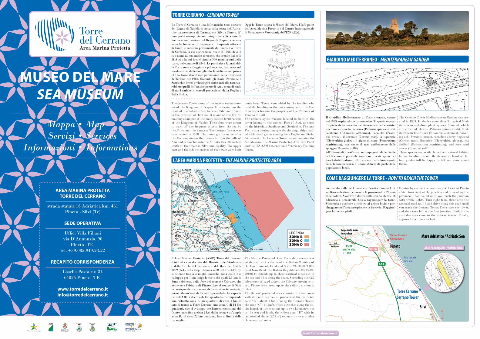
La Torre di Cerrano è una delle antiche torri costiere del Regno di Napoli, si trova sulla costa dell’Adria-tico, in provincia di Teramo, tra Silvi e Pineto. E’ uno pochi esempi rimasti integri della fitta rete di fortificazioni costiere del Regno di Napoli, che ave-vano la funzione di respingere i frequenti attacchi di turchi e saraceni provenienti dal mare. La Torre di Cerrano, la cui costruzione risale al 1568, deve il suo nome all’omonimo torrente, che scende dai colli di Atri e la cui foce é situata 500 metri a sud della torre, nel comune di Silvi. Le parti alte e laterali del-la Torre sono un’aggiunta più recente, realizzate nel secolo scorso dalle famiglie che la utilizzarono prima che la torre diventasse patrimonio della Provincia di Teramo nel 1981. Secondo gli storici Strabone e Sorricchio i resti archeologici antistanti alla torre sa-rebbero quelli dell’antico porto di Atri, meta di scalo di navi cariche di cereali provenienti dalla Puglia e dalla Sicilia.
Oggi la Torre ospita il Museo del Mare, l'Info-point dell'Area Marina Protetta e il Centro Internazionale di Formazione Veterinaria dell'IZS A&M.
TORRE CERRANO - CERRANO TOWER
L’AREA MARINA PROTETTA - THE MARINE PROTECTED AREA
GIARDINO MEDITERRANEO - MEDITERRANEAN GARDEN
L'Area Marina Protetta (AMP) Torre del Cerrano è istituita con decreto del Ministero dell'Ambiente e della Tutela del Territorio e del Mare del 21-10-2009 (G.U. della Rep. Italiana n.80 del 07-04-2010); si estende fino a 3 miglia nautiche dalla costa e si sviluppa per 7 km lungo la costa dei quali 2,5 km di duna sabbiosa, dalla foce del torrente Calvano, che attraversa l'abitato di Pineto, fino al centro di Silvi in corrispondenza, a mare, della stazione ferroviaria, formando un’area di forma trapezoidale. La superfi-cie dell'AMP è di circa 37 km quadrati e ricomprende una ristretta zona B, un quadrato di circa 1 km di lato di fronte a Torre Cerrano, una zona C di 14 km quadrati, che si sviluppa per l'intera estensione del fronte mare fino a circa 2 km dalla costa e un'ampia zona D, di circa 22 km quadrati, fino al limite delle tre miglia.
The Marine Protected Area Torre del Cerrano was established with a decree of the Italian Ministry of the Environment, Land and Sea in 21-10-2009 (Of-ficial Gazette of the Italian Republic no. 80; 07-04-2010); It extends up to three nautical miles out to the sea and 7 km along the coast. Spreading over 2.5 kilometres of sand dunes, the Calvano stream estu-ary, Pineto town area, up to the railway station in Silvi. The 37 km2 protected area consists of three areas with different degrees of protection: the restricted zone “B” (about 1 km2) facing the Cerrano Tower; the zone “C” (14 km2), which stretches along the en-tire length of the coastline up to two kilometres out to the sea; and lastly, the widest zone “D” with its trapezoidal shape (22 km2) extends up to a further three nautical miles.
The Cerrano Tower is one of the ancient coastal tow-ers of the Kingdom of Naples. It is located on the coast of the Adriatic Sea, between Silvi and Pineto in the province of Teramo. It is one of the few re-maining examples of the many coastal fortifications of the Kingdom of Naples. These forts were meant to ward off the frequent attacks from the sea by the Turks and the Saracens.The Cerrano Tower was constructed in 1568. The tower got its name after the Cerrano stream that descends from the hills of Atri and debouches into the Adriatic Sea 500 meters south of the tower in Silvi municipality. The upper part and the side extensions of the tower were built
much later. These were added by the families who used the building in the last century until the Cer-rano tower became the property of the Province of Teramo in 1981.The archaeological remains located in front of the tower belong to the ancient Port of Atri, as noted by the historians Strabone and Sorricchio. The Atri Port was a destination spot for the cargo ships load-ed with cereal grains coming from Puglia and Sicily.At present, the Cerrano Tower accommodates the Sea Museum, the Marine Protected Area Info Point and the IZS A&M International Veterinary Training Centre.
COME RAGGIUNGERE LA TORRE - HOW TO REACH THE TOWER
USCITAPINETO - ATRI
EXIT
Borgo Santa Maria Immacolata
AtriMutignano
Silvi
Mare Adriatico / Adriatic SeaStazione ferroviariaRailway station
IAT
Pineto
Pista ciclabileCycle lane
Torre CerranoCerrano Tower
MappaServizi
Informazioni
MapServicesInformations
•••
LEGENDAZONA BZONA CZONA D
Arrivando dalla A14 prendere l'uscita Pineto-Atri, svoltare a destra e percorrere la provinciale n.28 sino al semaforo. Svoltare a destra sulla strada statale 16 adriatica e percorrerla fino a raggiungere la torre. Superarla e svoltare a sinistra al primo bivio e par-cheggiare nell'area prospicente la ferrovia. Raggiun-gere la torre a piedi.
AREA PARCHEGGIO - PARKING AREA
A14
SS 16
Coming by car via the motorway A14 exit at Pineto - Atri, turn right at the junction and drive along the provincial road no. 28 until you reach the junction with traffic lights. Turn right from there onto the national road no. 16 and drive along this road until you reach the Cerrano Tower. Drive pass the tower, and then turn left at the first junction. Park in the available area close to the railway tracks. Finally, approach the tower on foot.
Il Giardino Mediterraneo di Torre Cerrano, creato nel 1983, ospita al suo interno oltre 30 specie vegeta-li tipiche della macchia mediterranea e dell’ecosiste-ma dunale come la marruca (Paliurus spina-christi), l'alaterno (Rhamnus alaternus), l'orniello (Fraxi-nus ornus), il corniolo (Cornus mas), la liquirizia (Glycyrrhiza glabra), il giglio di mare (Pancratium maritimum), ma anche il raro zafferanetto delle spiagge (Romulea rollii).All’interno di quest’area, accompagnati dalle Guide del Cerrano, è possibile ammirare queste specie nel loro habitat naturale oltre a scoprirne il loro signifi-cato, la loro bellezza, e il loro utilizzo da parte delle popolazioni locali.
The Cerrano Tower Mediterranean Garden was cre-ated in 1983. It abodes more than 30 typical Med-iterranean and dune plant species. Some of which are: crown of thorns (Paliurus spina-christi), Med-iterranean buckthorn (Rhamnus alaternus), flower-ing ash (Fraxinus ornus), cornelian cherry dogwood (Cornus mas), liquorice (Glycyrrhiza glabra), sea daffodil (Pancratium maritimum), and rare sand crocus (Romulea rollii).These species are available in their natural habitat for you to admire in our Mediterranean Garden. Our tour guides will be happy to tell you more about them.
InfopointInfopoint
Caffè letterarioLiterary cafè
BookshopBookshop
Aula didatticaClassroom
Consultazione archivi informaticiFile archives consultation
Conservazione volumiVolumes conservation
Saletta proiezioni, riunioni e conferenzeConference room
GIARDINO MEDITERRANEO / MEDITERRANEAN GARDENINGRESSO / ENTRANCE
www.torredelcerrano.it
MUSEO DEL MARESEA MUSEUM
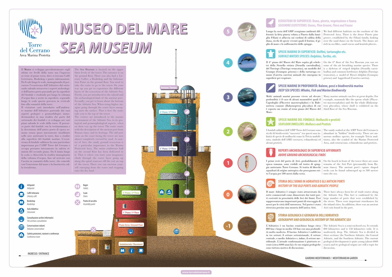
Il Museo si sviluppa prevalentemente sugli ultimi tre livelli della torre ma l’ingresso avviene al piano terra, dove si trovano Caffè Letterario, Bookshop e punto informazioni. Da lì sale lungo le scale, immaginando di per-correre l’ecosistema dell’Adriatico dal sotto-suolo salendo attraverso i reperti archeologi-ci dell'antico porto passando per la superficie del fondale e risalendo poi lungo la colonna d’acqua fino a uscire in superficie, seguendo lungo le scale questo percorso in verticale fino alla sommità della torre.Il visitatore sarà introdotto nell’ambien-te marino dell’Adriatico partendo dai suoi aspetti geologici e geomorfologici imme-desimandosi in una risalita che parte dal sottosuolo dei fondali e si sviluppa nei vari piani salendo le scale della torre. Il percor-so parte dal fondale con la testimonianza e la descrizione dell’antico porto di epoca ro-mana ormai quasi interamente insabbiato nelle aree antistanti la torre, fino a risalire alla superficie del fondale marino. L’ecosi-stema di fondale sabbioso ha una particolare importanza per l’AMP Torre del Cerrano e occupa pertanto interamente la saletta ri-unioni del secondo piano. Da lì inizia lungo la scala a chiocciola la risalita immaginaria della colonna d’acqua, fino ad arrivare con l’uscita in sommità della torre, che coincide con l’emersione dal mare e la fuoriuscita sul-la terraferma.
The Sea Museum is located on the upper three levels of the tower. The entrance is on the ground floor. There you also find a Lit-erary Coffee, a Bookshop and the Informa-tion Point on the ground floor. You need to take the stairs to go to the tower. On your way up you get to experience the different layers of the ecosystem of the Adriatic Sea. Firstly, you are introduced to the subsoil and the archaeological finds of the ancient port. Secondly, you get to learn about the bottom of the Adriatic Sea. When rising higher, im-agine going through the water layer emerg-ing unto the surface. That is how the stairs take you to the top of the tower.The visitors are introduced to the marine environment of the Adriatic Sea, to its geo-logical and geomorphological aspects, when on their way up the tower. The route starts with the description of the ancient port from Roman times and its heritage. The old port ruins on the coast facing the tower are now almost completely covered by sand. As mat-ter of fact, the sandy ground ecosystem is of a particular importance to the Marine Protected Area. The entire conference hall on the second floor has been dedicated to it. That is where you start your imaginary climb through the water layer going up along the spiral staircase till the exit on top of the tower. There you can envision your-self emerging from the water and stepping onto the dry land.
Piano Terra / Ground Floor
Seminterrato / Basement
1° Piano / 1st Floor
2° Piano / 2nd Floor
3° Piano / 3rd Floor
4° Piano / 4th Floor
Terrazza / Terrace
BagniToilets
ScaleStairs
Punto di raccoltaAssembly point
ECOSISTEMI DI SUPERFICIE: Duna, pineta, vegetazione e faunaSEASHORE ECOSYSTEMS: Dunes, Pine Groove, Flora and Fauna
Lungo la costa dell’AMP scorgiamo ambienti dif-ferenti: la fitta pineta voluta a Pineto dalla fami-glia Filiani si affaccia sui cordoni di sabbia della duna, ricchi di specie viventi quali il fratino, il gi-glio di mare e lo zafferanetto delle spiagge.
We find different habitats on the seashore of the Protected Area. There is the dense Pineto pine groove, established by the Filiani family, looking over the sand dunes on the beach. The dunes are rich in sea lilies, sand crocus and kentish plovers.
SPECIE MARINE DI SUPERFICIE: Delfini, tartarughe etc.SURFACE WATERS SPECIES: Dolphins, Turtles, etc.
Il 4° piano del Museo del Mare ospita gli schele-tri della Stenella striata (Stenella caeruloalba), del Tursiope (Tursiops truncatus), un modello del Grampo (Grampus griseus) e della tartaruga co-mune (Caretta caretta) animali che emergono in superficie per respirare.
On the 4th floor of the Sea Museum you can see some of the air breathing marine species. There is a skeleton of striped dolphin (Stenella caeru-loalba) and common bottlenose dolphin (Tursiops truncatus), a model of Risso's dolphin (Grampus griseus) and loggerhead (Caretta caretta).
SPECIE MARINE DI PROFONDITÀ: Balene, pesci e biodiversità marinaDEEP SEA SPECIES: Whales, Fish and Marine Biodiversity
Molti animali marini possono vivere ad elevate profondità: è il caso di alcuni mammiferi quali il Capodoglio (Physeter macrocephalus) e la Bale-nottera comune (Balaenoptera physalus) di cui è esposto un cranio al terzo piano del Museo del Mare.
Many marine animals can live at great depths. For example, mammals like the sperm whale (Physe-ter macrocephalus) and the fin whale (Balaenop-tera physalus), whose skull is exhibited on the third floor of the Sea Museum.
SPECIE MARINE DEL FONDALE: Molluschi e protistiSEAFLOOR DWELLERS: Molluscs and Protists
I fondali sabbiosi dell’AMP Torre del Cerrano sono ricchi di biodiversità “nascosta” tra questi una in-finità di specie di molluschi come la Trivia multili-rata, simbolo dell’AMP, crostacei, echinodermi ed alcuni protisti.
The sandy seabed at the AMP Torre del Cerrano is abundant in "hidden" biodiversity. There are nu-merous mollusc species, for example Trivia mul-tirata, also the symbol of the Marine Protected Area, and crustaceans, echinoderms and protists.
REPERTI ARCHEOLOGICI DI SUPERFICIE AFFIORANTIABOVE GROUND ARCHEOLOGICAL FINDS
I primi resti del porto di Atri, probabilmente di epoca romana, sono visibili sul tratto di spiag-gia antistante Torre Cerrano. Si tratta di blocchi squadrati di origine antropica che proseguono sot-to l’acqua per 500 metri dalla costa.
On the beach in front of the tower there are some remains of the Atri Port (presumably from Ro-man times). The ancient port’s square shaped rocks can be found submerged up to 500 meters onto the sea.
STORIA DELL’UOMO IN ADRIATICO E GLI ANTICHI PORTIHISTORY OF THE OLD PORTS AND ADRIATIC PEOPLE
Il mare Adriatico è sempre stato attraversato da rotte commerciali come dimostrato dai tanti por-ti costruiti in prossimità delle foci dei fiumi. Essi rappresentavano importanti punti di stoccaggio di merci per le città dell’entroterra. Nel porto è stata ritrovata persino una moneta dell’antica Atri.
There have always been lot of trade routes along the Adriatic Sea. This fact is confirmed by the large number of ports that were established by the rivers. These were important storehouses for the inland cities. In addition, there was an ancient Atri coin found in the port.
STORIA GEOLOGICA E GEOGRAFIA DELL’ADRIATICOGEOGRAPHY AND GEOLOGICAL HISTORY OF THE ADRIATIC SEA
L’Adriatico è un bacino semichiuso lungo circa 800 km e largo in media 150 km con una profondi-tà molto modesta. Il bacino Adriatico è suddiviso in tre settori: il settore settentrionale, il settore centrale, o medio Adriatico e, infine, il settore me-ridionale. L’attuale conformazione è piuttosto re-cente (circa 6000 anni fa) e le sue origini geologiche sono tuttora motivo di discussione.
The Adriatic Sea is a semi-enclosed sea. It extends 800 kilometres and is 150 kilometres wide. It is moderately deep. The Adriatic Sea is divided in three sections: the Northern Adriatic, the Central Adriatic, and the Southern Adriatic. The current geological development is quite young (about 6000 years) and its geological origins are still a topic for discussion.