Gestione del rischio da frana · Analisi del rischio da frana: intensità di un fenomeno franoso I...
57
Gestione del rischio da frana (inquadramento, definizioni e teoria) Università degli Studi di Salerno - Facoltà di Ingegneria – A.A. 2013-2014 Laurea Magistrale in Ingegneria per l’Ambiente ed il Territorio Corso di Frane Prof. ing. Michele Calvello
Transcript of Gestione del rischio da frana · Analisi del rischio da frana: intensità di un fenomeno franoso I...

Gestione del rischio da frana
(inquadramento, definizioni e teoria)
Università degli Studi di Salerno - Facoltà di Ingegneria – A.A. 2013-2014
Laurea Magistrale in Ingegneria per l’Ambiente ed il Territorio
Corso di Frane
Prof. ing. Michele Calvello

Articoli principali
Il rischio da frana. Ferlisi S. (2004). Non pubblicato.
Glossary of Risk Assessment Terms. ISSMGE TC32 - Technical Committee on Risk Assessment and Management (2004). Web
(http://www.engmath.dal.ca/tc32/publications.html).
A framework for landslide risk assessment and management. Fell R., Ho K.K.S., Lacasse S., Leroi E. (2005). In: Landslide Risk
Management, 3-25. Taylor & Francis, ISBN-13: 978-0415380430.
Gestione del rischio da frana > Dispense
Pro
f. M
ichel
e C
alvel
lo (
20
13
). C
ors
o d
i F
rane,
A.A
. 2
01
3-2
01
4, U
niv
ersi
tà d
i S
aler
no
, IT
AL
Y
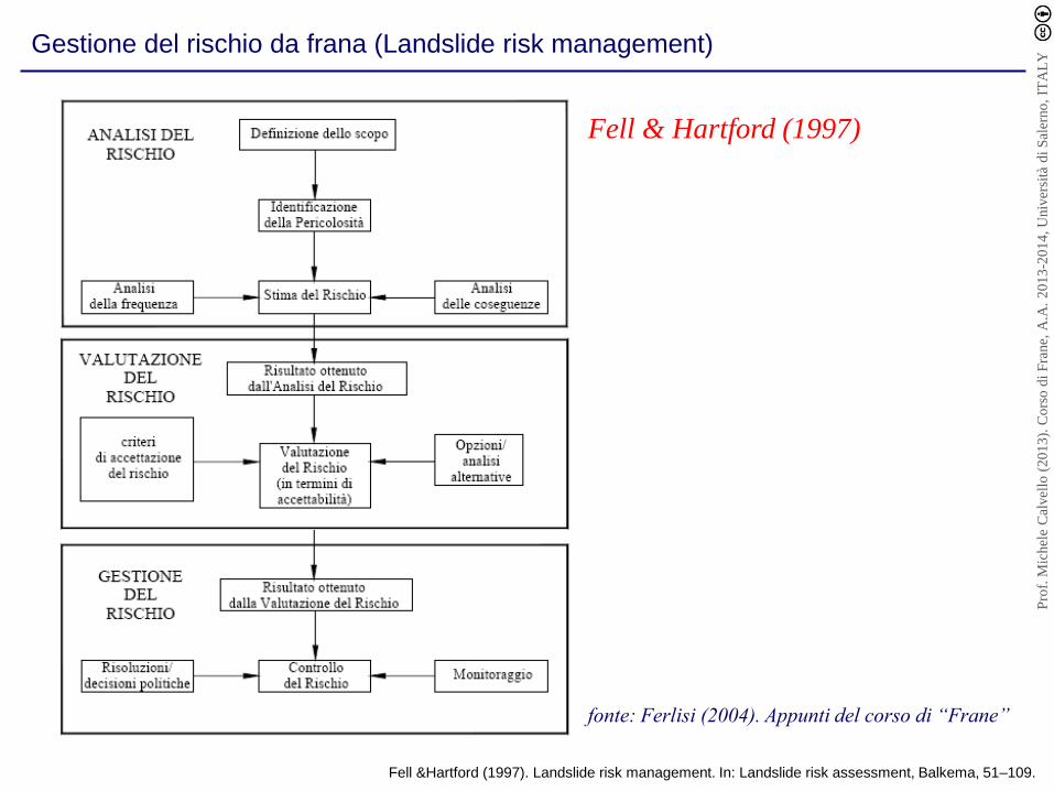
Gestione del rischio da frana (Landslide risk management)
Fell &Hartford (1997). Landslide risk management. In: Landslide risk assessment, Balkema, 51–109.
fonte: Ferlisi (2004). Appunti del corso di “Frane”
Fell & Hartford (1997)
Pro
f. M
ichel
e C
alvel
lo (
20
13
). C
ors
o d
i F
rane,
A.A
. 2
01
3-2
01
4, U
niv
ersi
tà d
i S
aler
no
, IT
AL
Y

Gestione del rischio da frana (Landslide risk management)
Ho et al. (2000). Quantitative risk assessment — application, myths and future direction.
Proc. Int. Conf. Geotechnical and Geological Engineering, GEOENG 2000, Melbourne, Australia, 1:236 – 312.
Ho et al. (2000)
Pro
f. M
ichel
e C
alvel
lo (
20
13
). C
ors
o d
i F
rane,
A.A
. 2
01
3-2
01
4, U
niv
ersi
tà d
i S
aler
no
, IT
AL
Y

Gestione del rischio da frana (Landslide risk management)
Fell et al. (2005). A framework for landslide risk assessment and management. In: Landslide Risk Management, 3-25. ISBN-13: 978-0415380430.
Fell et al. (2005)
Pro
f. M
ichel
e C
alvel
lo (
20
13
). C
ors
o d
i F
rane,
A.A
. 2
01
3-2
01
4, U
niv
ersi
tà d
i S
aler
no
, IT
AL
Y

Gestione del rischio da frana (Landslide risk management)
Pro
f. M
ichel
e C
alvel
lo (
20
13
). C
ors
o d
i F
rane,
A.A
. 2
01
3-2
01
4, U
niv
ersi
tà d
i S
aler
no
, IT
AL
Y

Gestione del rischio da frana (Landslide risk management)
Pro
f. M
ichel
e C
alvel
lo (
20
13
). C
ors
o d
i F
rane,
A.A
. 2
01
3-2
01
4, U
niv
ersi
tà d
i S
aler
no
, IT
AL
Y

Gestione del rischio da frana (Landslide risk management)
Pro
f. M
ichel
e C
alvel
lo (
20
13
). C
ors
o d
i F
rane,
A.A
. 2
01
3-2
01
4, U
niv
ersi
tà d
i S
aler
no
, IT
AL
Y
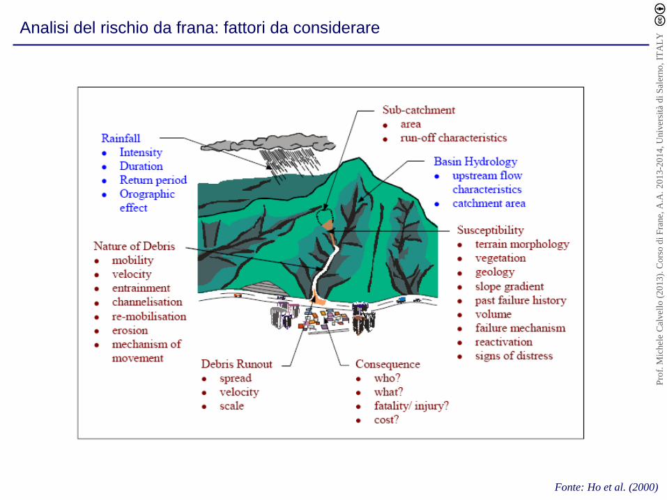
Analisi del rischio da frana: fattori da considerare
Fonte: Ho et al. (2000)
Pro
f. M
ichel
e C
alvel
lo (
20
13
). C
ors
o d
i F
rane,
A.A
. 2
01
3-2
01
4, U
niv
ersi
tà d
i S
aler
no
, IT
AL
Y

Analisi del rischio da frana: formule di calcolo
Hazard o Pericolosità (H): probabilità di accadimento, all’interno di una certa area
e in un certo intervallo di tempo, di un fenomeno naturale di assegnata intensità.
Elementi a Rischio (E): persone e/o beni (abitazioni, strutture, infrastrutture, ecc.)
e/o attività (economiche, sociali, ecc.) esposte “a rischio” in una certa area.
Vulnerabilità (V): grado di perdita di un certo elemento o insiemi di elementi
esposti “a rischio”, derivante dal verificarsi di un fenomeno naturale di assegnata
intensità, espresso in una scala che va da 0 (nessuna perdita) a 1 (perdita totale).
Rischio specifico (RS): grado previsto di perdita a seguito di un particolare
fenomeno naturale. Può essere espresso come prodotto di H x V.
Rischio totale (R): numero atteso di vittime, persone ferite, danni a proprietà,
distruzione o interruzione di attività economiche, in conseguenze di un fenomeno
naturale di assegnata intensità.
R = H x V x E = RS x E (Varnes 1978)
Varnes (1978). Slope movement types and processes. In: Special Report 176: Landslides: Analysis and Control,
Transportation and Road Research Board, National Academy of Science, 11–33.
Pro
f. M
ichel
e C
alvel
lo (
20
13
). C
ors
o d
i F
rane,
A.A
. 2
01
3-2
01
4, U
niv
ersi
tà d
i S
aler
no
, IT
AL
Y

Analisi del rischio da frana: formule di calcolo
R = H x V x E = RS x E (Varnes 1978)
Einstein (1988)
Fell (1994)
RISK = HAZARD x POTENTIAL WORTH OF LOSS
R = ( E x Rs ) = ( E x H x V )
Leroi (1997)
R = f [Pe, Pt, P’e (MVT, I, X, Y, Z, t, D, V, a, %, C)]
Einstein (1988). Landslide risk assessment procedure. Proc. V Int. Sym. on Landslides, ISL, 1:1075–1090.
Fell (1994). Landsldie risk assessment and acceptable risk. Canadian Geotechnical Journal, 31:261–272.
Leroi (1997). Landslide Risk Mapping: Problems, Limitation and Developments. In: Landslide Risk Assessment, Balkema, 239–250.
Pro
f. M
ichel
e C
alvel
lo (
20
13
). C
ors
o d
i F
rane,
A.A
. 2
01
3-2
01
4, U
niv
ersi
tà d
i S
aler
no
, IT
AL
Y

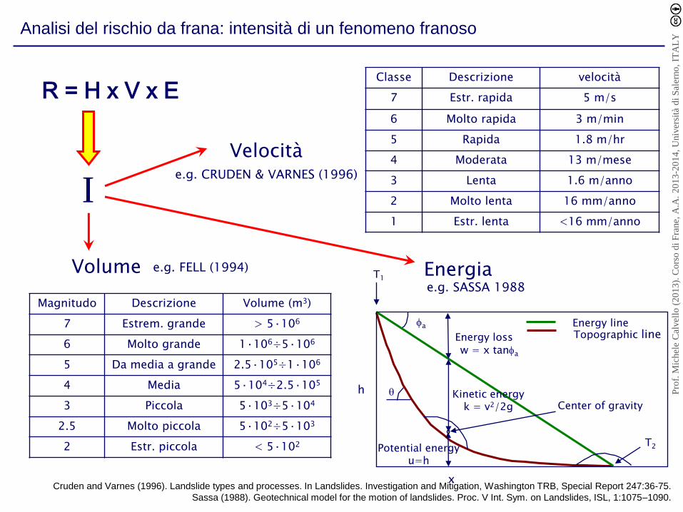
Analisi del rischio da frana: intensità di un fenomeno franoso
I
R = H x V x E
La “severità” di una frana dipende da una serie di parametri, quantitativi o
qualitativi spazialmente distribuiti, spesso di non facile valutazione.
A seconda del tipo di frana, i parametri che caratterizzano l’intensità di un
fenomeno franoso possono includere:
• la velocità degli spostamenti (movimenti),
• la profondità,
• lo spessore dei depositi,
• il volume della massa spostata,
• le pressioni d’impatto,
• la profondità d’erosione,
• i movimenti differenziali,
• etc.
fonte: Ferlisi (2004). Appunti del corso di “Frane”
Pro
f. M
ichel
e C
alvel
lo (
20
13
). C
ors
o d
i F
rane,
A.A
. 2
01
3-2
01
4, U
niv
ersi
tà d
i S
aler
no
, IT
AL
Y
Analisi del rischio da frana: intensità di un fenomeno franoso
Magnitudo Descrizione Volume (m3)
7 Estrem. grande > 5·106
6 Molto grande 1·106÷5·106
5 Da media a grande 2.5·105÷1·106
4 Media 5·104÷2.5·105
3 Piccola 5·103÷5·104
2.5 Molto piccola 5·102÷5·103
2 Estr. piccola < 5·102
Classe Descrizione velocità
7 Estr. rapida 5 m/s
6 Molto rapida 3 m/min
5 Rapida 1.8 m/hr
4 Moderata 13 m/mese
3 Lenta 1.6 m/anno
2 Molto lenta 16 mm/anno
1 Estr. lenta <16 mm/anno
T2
Topographic line fa
Energy loss w = x tanfa
T1
Center of gravity
Energy line
Kinetic energy k = v2/2g
Potential energy u=h
h
x
q
Velocità e.g. CRUDEN & VARNES (1996)
e.g. FELL (1994) Volume e.g. SASSA 1988
Energia
I
R = H x V x E
Cruden and Varnes (1996). Landslide types and processes. In Landslides. Investigation and Mitigation, Washington TRB, Special Report 247:36-75.
Sassa (1988). Geotechnical model for the motion of landslides. Proc. V Int. Sym. on Landslides, ISL, 1:1075–1090.
Pro
f. M
ichel
e C
alvel
lo (
20
13
). C
ors
o d
i F
rane,
A.A
. 2
01
3-2
01
4, U
niv
ersi
tà d
i S
aler
no
, IT
AL
Y

Analisi del rischio da frana: intensità di un fenomeno franoso (velocità)
Velocità attuale Massima velocità attesa
V~0
Pre-rottura Post-rottura
V~0
Vmax
V~0
La velocità di una frana cambia con il tempo in funzione del suo stadio evolutivo
Fonte: Cascini (LARAM School)
LARAM School. International School on "LAndslide Risk Assessment and Mitigation" of the University of Salerno. http://www.laram.unisa.it
Pro
f. M
ichel
e C
alvel
lo (
20
13
). C
ors
o d
i F
rane,
A.A
. 2
01
3-2
01
4, U
niv
ersi
tà d
i S
aler
no
, IT
AL
Y

Analisi del rischio da frana: intensità di un fenomeno franoso (volume)
Weymouth, UK
Laguna Beach, USA
(frana causata da un sistema di irrigazione malfunzionante)
VOLUME = 300 m3
VOLUME = 800 m3
Frane di piccole dimensioni
modificato da Cascini (LARAM School)
Pro
f. M
ichel
e C
alvel
lo (
20
13
). C
ors
o d
i F
rane,
A.A
. 2
01
3-2
01
4, U
niv
ersi
tà d
i S
aler
no
, IT
AL
Y
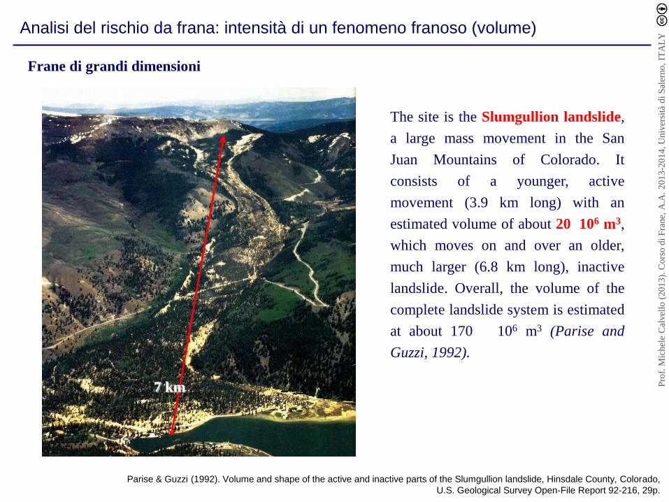
Analisi del rischio da frana: intensità di un fenomeno franoso (volume)
The site is the Slumgullion landslide,
a large mass movement in the San
Juan Mountains of Colorado. It
consists of a younger, active
movement (3.9 km long) with an
estimated volume of about 20
106 m3,
which moves on and over an older,
much larger (6.8 km long), inactive
landslide. Overall, the volume of the
complete landslide system is estimated
at about 170
106 m3 (Parise and
Guzzi, 1992).
Frane di grandi dimensioni
7 km
Parise & Guzzi (1992). Volume and shape of the active and inactive parts of the Slumgullion landslide, Hinsdale County, Colorado,
U.S. Geological Survey Open-File Report 92-216, 29p.
Pro
f. M
ichel
e C
alvel
lo (
20
13
). C
ors
o d
i F
rane,
A.A
. 2
01
3-2
01
4, U
niv
ersi
tà d
i S
aler
no
, IT
AL
Y

Analisi del rischio da frana: intensità di un fenomeno franoso (energia cinetica)
modificato da Cascini (LARAM School)
Crolli in roccia
Le barriere paramassi sono progettate considerando l’energia cinetica
dei blocchi che devono intercettare
Pro
f. M
ichel
e C
alvel
lo (
20
13
). C
ors
o d
i F
rane,
A.A
. 2
01
3-2
01
4, U
niv
ersi
tà d
i S
aler
no
, IT
AL
Y

Analisi del rischio da frana: intensità di un fenomeno franoso (energia cinetica)
Crolli in roccia
>=2000 kJ
1500 - 2000 kJ
1000 - 1500 kJ
500 - 1000 kJ 0 - 500 kJ
TRAJECTORIES ENERGIES
Trajectories (left) and kinetic energy distribution (right)
(Copons et al. 2005)
Rockfall area of the Solà d’Andorra, Spain
(Corominas et al. 2003)
Corominas et al. (2003). Integrated Landslide Susceptibility Analysis and Hazard Assessment in the Principality of Andorra. Natural Hazards, 30(3):421-435.
Copons et al. (2005). Rockfall hazard management policy in urban areas: the Andorran experience. In: Landslide Hazard and Risk, John Wiley&Sons, 675-698.
Pro
f. M
ichel
e C
alvel
lo (
20
13
). C
ors
o d
i F
rane,
A.A
. 2
01
3-2
01
4, U
niv
ersi
tà d
i S
aler
no
, IT
AL
Y

Zonazione del rischio da frana (i.e. produzione di mappe di rischio)
Quale fenomeno?
Dove? Quali conseguenze?
Quando?
modificato da Cascini (LARAM School)
Pro
f. M
ichel
e C
alvel
lo (
20
13
). C
ors
o d
i F
rane,
A.A
. 2
01
3-2
01
4, U
niv
ersi
tà d
i S
aler
no
, IT
AL
Y

Framework generale per la zonazione della pericolosità e del rischio da frana
Caratterizzazione del fenomeno
(Aree suscettibili, Intensità, Data sets)
Mappe di Suscettibilità
Stima della frequenza
Mappe di Pericolosità
Mappe del Rischio
Analisi della probabilità e della
severità delle conseguenza
Scenari di conseguenze
(Elementi a rischio, Vulnerabilità)
Cascini et al. (2005)
Cascini et al. (2005). Landslide hazard and risk zoning for urban planning and development. In: Landslide Risk Management, Balkema, 199-235.
Pro
f. M
ichel
e C
alvel
lo (
20
13
). C
ors
o d
i F
rane,
A.A
. 2
01
3-2
01
4, U
niv
ersi
tà d
i S
aler
no
, IT
AL
Y

Caratterizzazione del fenomeno franoso
Area di versante propensa alla instabilità o area all’interno della quale un
fenomeno franoso può propagarsi o può retrogredire. Per un frana esistente, la
suscettibilità esprime la sua potenzialità alla riattivazione.
Area suscettibile
Intensità della frana
Dataset
E’ data da un insieme di parametri, spazialmente distribuiti, che consentono di
descrivere, in termini geometrici e meccanici, la severità di un fenomeno
Insieme di dati che può consentire una chiara identificazione della suscettibilità
di un versante ad essere sede di ben precise tipologie di frana.
modificato da Cascini (LARAM School)
Pro
f. M
ichel
e C
alvel
lo (
20
13
). C
ors
o d
i F
rane,
A.A
. 2
01
3-2
01
4, U
niv
ersi
tà d
i S
aler
no
, IT
AL
Y

Suscettibilità
localizzazione
classificazione
estensione areale e volume
aree in creep
stato di attività
l’area in cui la frana potrebbe
Inventa
rio d
ei fe
nom
eni
Le aree suscettibili alla franosità dovrebbero segnalare:
propagarsi
retrogredire
espandersi
modificato da Cascini (LARAM School)
Pro
f. M
ichel
e C
alvel
lo (
20
13
). C
ors
o d
i F
rane,
A.A
. 2
01
3-2
01
4, U
niv
ersi
tà d
i S
aler
no
, IT
AL
Y

Suscettibilità
Frana di Lioni
(Cotecchia et al. 1992)
Classificazione: scorrimento di terra
Estenzione areale: 6 ha
Volume: 291.000 m3
Cotecchia et al. (2005). Comportamento geotecnico delle unità sicilidi e irpine affioranti nelle alte valli dei fiumiSele ed Ofanto ad elevato rischio sismotettonico.
Geologia Applicata ed Idrogeologia, 27:1-49.
Pro
f. M
ichel
e C
alvel
lo (
20
13
). C
ors
o d
i F
rane,
A.A
. 2
01
3-2
01
4, U
niv
ersi
tà d
i S
aler
no
, IT
AL
Y

Suscettibilità
a) b)
Area in cui la frana può propagarsi
Quindici (Maggio, 1998) Nakaba (Luglio, 1983)
modificato da Cascini (LARAM School)
Pro
f. M
ichel
e C
alvel
lo (
20
13
). C
ors
o d
i F
rane,
A.A
. 2
01
3-2
01
4, U
niv
ersi
tà d
i S
aler
no
, IT
AL
Y
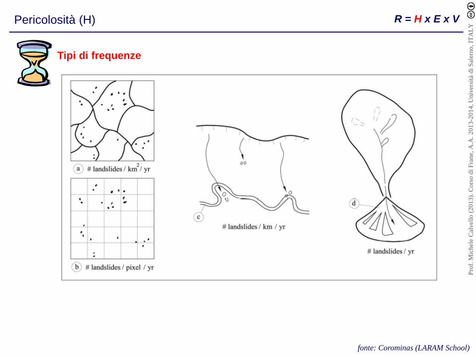
Pericolosità (H) R = H x E x V
Tipi di frequenze
fonte: Corominas (LARAM School)
Pro
f. M
ichel
e C
alvel
lo (
20
13
). C
ors
o d
i F
rane,
A.A
. 2
01
3-2
01
4, U
niv
ersi
tà d
i S
aler
no
, IT
AL
Y

Metodi impiegati per la stima della frequenza
Pericolosità (H) R = H x E x V
Fonte: IUGS Working Group on Landslides, Commitee on Risk Assessment,
Proc. on Landslide Risk Assessment, Honululu (1997)
1. Stima diretta basata sul giudizio di esperti.
2. Metodi empirici basati su correlazioni
3. Evidenze di tipo geomorfologico (congiunte a dati storici o basate sull’esperienza)
4. Dati storici concernenti l’area di studio, o aree di caratteristiche geologiche e
geomorfologiche simili.
5. Correlazioni con la frequenza di accadimento delle cause di innesco (piogge, sisma, …)
di fissata intensità
6. Modellazione fisicamente basata del legame funzionale tra pressioni neutre e piogge, in
combinazione con informazioni legate alla geometria del sistema e ai valori di
resistenza al taglio (mobilitata e disponibile)
7. Applicazione di metodi probabilistici, basati su analisi di affidabilità, in grado di tenere
conto delle incertezze nella geometria del sistema, nella resistenza al taglio disponibile,
nei meccanismi di scorrimento e nel regime delle pressioni neutre.
8. Combinazioni dei metodi precedenti.
Pro
f. M
ichel
e C
alvel
lo (
20
13
). C
ors
o d
i F
rane,
A.A
. 2
01
3-2
01
4, U
niv
ersi
tà d
i S
aler
no
, IT
AL
Y
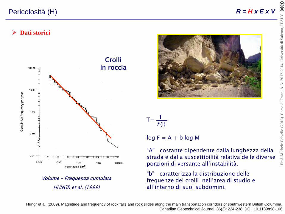
Pericolosità (H) R = H x E x V
HUNGR et al. (1999)
Volume – Frequenza cumulata
log F = A + b log M
“A” costante dipendente dalla lunghezza della strada e dalla suscettibilità relativa delle diverse porzioni di versante all’instabilità.
“b” caratterizza la distribuzione delle frequenze dei crolli nell’area di studio e all’interno di suoi subdomini.
= (i)
1 T f
Crolli in roccia
Dati storici
Hungr et al. (2009). Magnitude and frequency of rock falls and rock slides along the main transportation corridors of southwestern British Columbia.
Canadian Geotechnical Journal, 36(2): 224-238, DOI: 10.1139/t98-106
Pro
f. M
ichel
e C
alvel
lo (
20
13
). C
ors
o d
i F
rane,
A.A
. 2
01
3-2
01
4, U
niv
ersi
tà d
i S
aler
no
, IT
AL
Y

Pericolosità (H) R = H x E x V
Metodi probabilistici (1/2)
Haneberg (2004). A Rational Probabilistic Method for Spatially Distributed Landslide Hazard Assessment.
Environmental & Engineering Geoscience, 10(1): 27-43.
Pro
f. M
ichel
e C
alvel
lo (
20
13
). C
ors
o d
i F
rane,
A.A
. 2
01
3-2
01
4, U
niv
ersi
tà d
i S
aler
no
, IT
AL
Y

Pericolosità (H) R = H x E x V
modificato da Corominas (LARAM School)
Metodi probabilistici (2/2)
1E
R
PT
TR return period of the event
( average # of years between two events equally or exceeding magnitude M)
Annual exceedance probability (PE)
N(t) number of landslide (or landslide clusters) o a given
magnitude expected to occur during a specified time
interval (t)
m future mean recurrence interval
Poisson probability models
( ) 1 1
t
P N t e m
Pro
f. M
ichel
e C
alvel
lo (
20
13
). C
ors
o d
i F
rane,
A.A
. 2
01
3-2
01
4, U
niv
ersi
tà d
i S
aler
no
, IT
AL
Y

Pericolosità (H) R = H x E x V
ground surface
bedrock
land cover
water table
slip surface
bedrock
land cover
h
z
Topografia Analisi topografica di un’area
Idrologia Pressioni neutre
Vegetazione Influenza della vegetazione sui processi idrologici e la stabilità del pendio
Stabilità del pendio Coefficiente di sicurezza
Modelli fisicamente basati (su area vasta)
fonte: Cascini (LARAM School)
Pro
f. M
ichel
e C
alvel
lo (
20
13
). C
ors
o d
i F
rane,
A.A
. 2
01
3-2
01
4, U
niv
ersi
tà d
i S
aler
no
, IT
AL
Y

Pericolosità (H) R = H x E x V
Modelli fisicamente basati (su area vasta)
fonte: Sorbino (LARAM School)
TRANSIENT ANALYTICAL MODELS
GROUNDWATER
MODELS
(Richards’ Equation)
LIMIT EQUILIBRIUM
METHODS
STEADY
STATE
MODELS
TRANSIENT
MODELS
PISTON FLOW
MODELS
UNSATURATED
MODELS
SATURATED
DIFFUSION
MODELS
Pore water pressures
Factor of Safety
KINEMATIC
WAVE
MODELS
COUPLED
SATURATED/
UNSATURATED
MODELS
TRANSIENT NUMERICAL MODELS
STEADY STATE ANALYTICAL MODELS
Distributed Physically Based Models Uncoupled Slope
Stability Analysis
INFINITE
SLOPE
MODEL
SHALSTAB
TRIGRS
TRIGRS-unsaturated
(Montgomery & Dietrich, 1994)
(Savage et al., 2004; 2008)
(Baum et al., 2002)
Pro
f. M
ichel
e C
alvel
lo (
20
13
). C
ors
o d
i F
rane,
A.A
. 2
01
3-2
01
4, U
niv
ersi
tà d
i S
aler
no
, IT
AL
Y

Elementi a Rischio (E) R = H x E x V
fonte: Cascini (LARAM School)
Un casa di campagna
(poche persone)
Un piccolo villaggio
(decine di persone)
Una grande città
(centinaia di persone)
Pro
f. M
ichel
e C
alvel
lo (
20
13
). C
ors
o d
i F
rane,
A.A
. 2
01
3-2
01
4, U
niv
ersi
tà d
i S
aler
no
, IT
AL
Y

Elementi a Rischio (E) R = H x E x V
fonte: Cascini (LARAM School)
Sito di interesse storico-archeologico
Abitazioni Edifici pubblici
Patrimonio mondiale UNESCO
Pro
f. M
ichel
e C
alvel
lo (
20
13
). C
ors
o d
i F
rane,
A.A
. 2
01
3-2
01
4, U
niv
ersi
tà d
i S
aler
no
, IT
AL
Y

Vulnerabilità (V) R = H x E x V
La vulnerabilità degli elementi esposti a rischio dipende dalla tipologia dell’elemento
(e quindi dalla sua resistenza) e dall’intensità del fenomeno franoso con cui interagisce.
Vulnerabilità FISICA
Vulnerabilità SOCIALE
Vulnerabilità ECONOMICA
Vulnerabilità AMBIENTALE
Strutture, infrastrutture, reti di servizio, strutture di
interesse strategico
Popolazione
Danni all’ambiente naturale
Attività economiche
e.g. Leone et al. (1996)
Leone et al. (1996). Vulnerability assessment of elements exposed to mass moving: working towards a better risk perception.
In: Landslides, Balkema, 263–269.
Pro
f. M
ichel
e C
alvel
lo (
20
13
). C
ors
o d
i F
rane,
A.A
. 2
01
3-2
01
4, U
niv
ersi
tà d
i S
aler
no
, IT
AL
Y

Vulnerabilità (V) R = H x E x V
Direct approach. L’approccio diretto coinvolge la
valutazione diretta delle conseguenze basata
sull’esperienza e sul giudizio di un esperto senza
tener presente quelle che sono le componenti dello
scenario coinvolto.
The event tree approach. L’approccio è basato sulla
“logica ad albero” e del ragionamento induttivo per
traslare le differenti componenti dello scenario in un
range di possibili soluzioni.
The consequence model. Il modello coinvolge l’uso
di una struttura razionale basata sulla considerazione
dei fattori chiave riguardanti i danni da rottura, come
la distanza di propagazione del fenomeno franoso, il
tipo e la vicinanza delle strutture colpite, la
distribuzione spaziale e temporale della popolazione a
rischio.
Diversi approcci per la valutazione della Vulnerabilità:
(Wong et al. 1997)
Wong et al. (1997). Assessment of consequence of landslides. In: Landslide Risk Assessment. Balkema, 111 -149.
Pro
f. M
ichel
e C
alvel
lo (
20
13
). C
ors
o d
i F
rane,
A.A
. 2
01
3-2
01
4, U
niv
ersi
tà d
i S
aler
no
, IT
AL
Y

Valutazione del Rischio
Criteri di accettabilità e tollerabilità del Rischio adottati nel territorio di Hong Kong (ERM 1988).
ERM (1988). Landslides and Boulder Falls from Natural Terrain: Interim Risk Guidelines. GEO Report No. 75, Hong Kong, 183p.
Pro
f. M
ichel
e C
alvel
lo (
20
13
). C
ors
o d
i F
rane,
A.A
. 2
01
3-2
01
4, U
niv
ersi
tà d
i S
aler
no
, IT
AL
Y
Mitigazione del Rischio
La mitigazione del rischio può essere attuata secondo due strategie:
1) Riducendo uno o più dei fattori che concorrono alla definizione del Rischio
Riducendo la pericolosità (H)
L’incidenza dei fenomeni franosi in una data area può essere ridotta in due modi:
- intervenendo sulle cause dei fenomeni franosi, per esempio mediante opere di bonifica e
di sistemazione idrologica del territorio, oppure attraverso la razionalizzazione delle
pratiche agricole o di utilizzo del suolo.
- intervenendo direttamente sui fenomeni franosi esistenti al fine di prevenire la loro
riattivazione o limitare la loro evoluzione.
Pro
f. M
ichel
e C
alvel
lo (
20
13
). C
ors
o d
i F
rane,
A.A
. 2
01
3-2
01
4, U
niv
ersi
tà d
i S
aler
no
, IT
AL
Y

Mitigazione del Rischio
La mitigazione del rischio può essere attuata secondo due strategie:
1) Riducendo uno o più dei fattori che concorrono alla definizione del Rischio
Riducendo gli elementi a rischio (E)
Tale strategia si esplica soprattutto in sede di pianificazione territoriale e di normativa,
nell’ambito delle quali possono essere programmate le seguenti azioni:
- evacuazione di aree instabili e trasferimento dei centri abitati soggetti a pericolo;
- interdizione o limitazione dell’espansione urbanistica in zone pericolose;
- definizione dell’utilizzo del suolo più consono per le aree pericolose (es. prato-pascolo,
parchi, etc.)
Pro
f. M
ichel
e C
alvel
lo (
20
13
). C
ors
o d
i F
rane,
A.A
. 2
01
3-2
01
4, U
niv
ersi
tà d
i S
aler
no
, IT
AL
Y

Mitigazione del Rischio
La mitigazione del rischio può essere attuata secondo due strategie:
1) Riducendo uno o più dei fattori che concorrono alla definizione del Rischio
Riducendo la vulnerabilità (V)
La vulnerabilità può essere ridotta mediante interventi di tipo tecnico oppure intervenendo
sull’organizzazione sociale del territorio:
- consolidamento degli edifici, che determina una riduzione della probabilità di
danneggiamento dell’elemento interessato dalla frana;
- installazione di misure di protezione quali reti o strutture paramassi (parapetti,, gallerie,
rilevati o trincee), in modo da determinare una riduzione della probabilità che
l’elemento a rischio venga interessato dalla frana (senza tuttavia limitare la probabilità
di occorrenza di questa).
Pro
f. M
ichel
e C
alvel
lo (
20
13
). C
ors
o d
i F
rane,
A.A
. 2
01
3-2
01
4, U
niv
ersi
tà d
i S
aler
no
, IT
AL
Y

Mitigazione del Rischio
La mitigazione del rischio può essere attuata secondo due strategie:
2) Aumentando le soglie di Rischio accettabile/tollerabile
fonte: Sorbino (LARAM School)
Pro
f. M
ichel
e C
alvel
lo (
20
13
). C
ors
o d
i F
rane,
A.A
. 2
01
3-2
01
4, U
niv
ersi
tà d
i S
aler
no
, IT
AL
Y

Risk theory and risk factors have a clear meaning
Evaluation of risk factors calls for many difficulties
VARNES
(1984)
created in
1999
Int. Conf. on
Landslide Risk Management,
Vancouver, Canada (2005)
Institutional progress
1990-2010
International Decade for Natural Disaster Reduction (UN)
Scientific advances
ISL
(International Symposium on Landslides)
LARAM School, University of Salerno
(2006-ongoing)
(2008)
(2012)
Teoria del rischio e “gestione del rischio da frana”
R = H x V x E = RS x E
EU funded research projects
Pro
f. M
ichel
e C
alvel
lo (
20
13
). C
ors
o d
i F
rane,
A.A
. 2
01
3-2
01
4, U
niv
ersi
tà d
i S
aler
no
, IT
AL
Y

“Landslide Risk Management” (2005)
Proceedings of the International Conference on Landslide Risk Management
(May 31 - June 3, 2005. Vancouver, Canada)
Editors: O. Hungr, R. Fell, R. Couture, E. Eberhardt
1st Part (state-of-the-art and invited lectures)
SOA 1. A framework for landslide risk assessment and management (Fell, Ho, Lacasse, Leroi)
SOA 2. Hazard characterization and quantification (Picarelli, Oboni, Evans, Mostyn, Fell)
SOA 3. Probabilistic stability analysis for individual slopes in soil and rock (Nadim, Einstein, Roberds)
SOA 4. Estimating landslide motion mechanism, travel distance and velocity (Hungr, Corominas, Eberhardt)
SOA 5. Estimating temporal and spatial variability and vulnerability (Roberds)
SOA 6. Risk assessment and management (Leroi, Bonnard, Fell, McInnes)
SOA 7. Landslide hazard and risk zoning for urban planning and development
(Cascini, Bonnard, Corominas, Jibson, Montero-Olarte)
SOA 8. Landslide risk assessment for individual facilities (Wong)
2nd Part (selection of papers submitted to the conference)
Pro
f. M
ichel
e C
alvel
lo (
20
13
). C
ors
o d
i F
rane,
A.A
. 2
01
3-2
01
4, U
niv
ersi
tà d
i S
aler
no
, IT
AL
Y

“A framework for landslide risk assessment and management” (Fell et al. 2005)
Terminology
Danger (Threat). The natural phenomenon that could lead to damage, described in terms of its
geometry, mechanical and other characteristics. The danger can be an existing one (such as a
creeping slope) or a potential one (such as a rockfall). The characterisation of a danger or threat does
not include any forecasting.
Hazard. Probability that a particular danger (threat) occurs within a given period of time.
Likelihood. Conditional probability of an outcome given a set of data, assumptions and information.
Also used as a qualitative description of probability and frequency.
Probability. A measure of the degree of certainty. This measure has a value between zero
(impossibility) and 1.0 (certainty). It is an estimate of the likelihood of the magnitude of the uncertain
quantity, or the likelihood of the occurrence of the uncertain future event.
Risk. Measure of the probability and severity of an adverse effect to life, health, property, or the
environment. Quantitatively, Risk = Hazard x Potential Worth of Loss. This can be also expressed as
“Probability of an adverse event times the consequences if the event occurs”.
Pro
f. M
ichel
e C
alvel
lo (
20
13
). C
ors
o d
i F
rane,
A.A
. 2
01
3-2
01
4, U
niv
ersi
tà d
i S
aler
no
, IT
AL
Y
“A framework for landslide risk assessment and management” (Fell et al. 2005)
Terminology
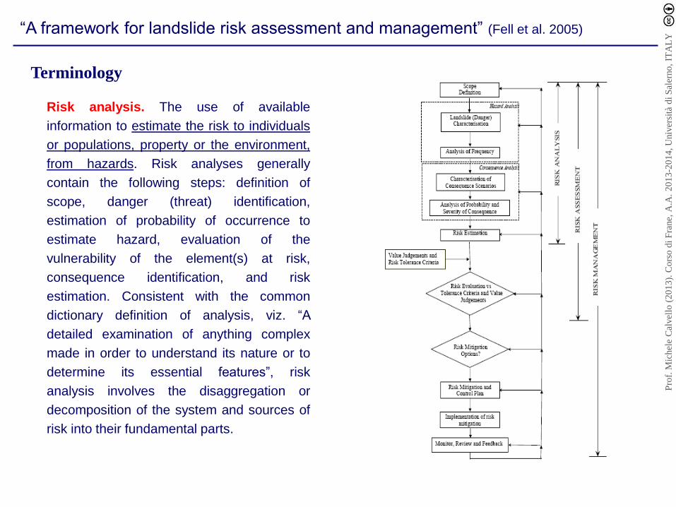
Risk analysis. The use of available
information to estimate the risk to individuals
or populations, property or the environment,
from hazards. Risk analyses generally
contain the following steps: definition of
scope, danger (threat) identification,
estimation of probability of occurrence to
estimate hazard, evaluation of the
vulnerability of the element(s) at risk,
consequence identification, and risk
estimation. Consistent with the common
dictionary definition of analysis, viz. “A
detailed examination of anything complex
made in order to understand its nature or to
determine its essential features”, risk
analysis involves the disaggregation or
decomposition of the system and sources of
risk into their fundamental parts.
Pro
f. M
ichel
e C
alvel
lo (
20
13
). C
ors
o d
i F
rane,
A.A
. 2
01
3-2
01
4, U
niv
ersi
tà d
i S
aler
no
, IT
AL
Y
“A framework for landslide risk assessment and management” (Fell et al. 2005)
Terminology
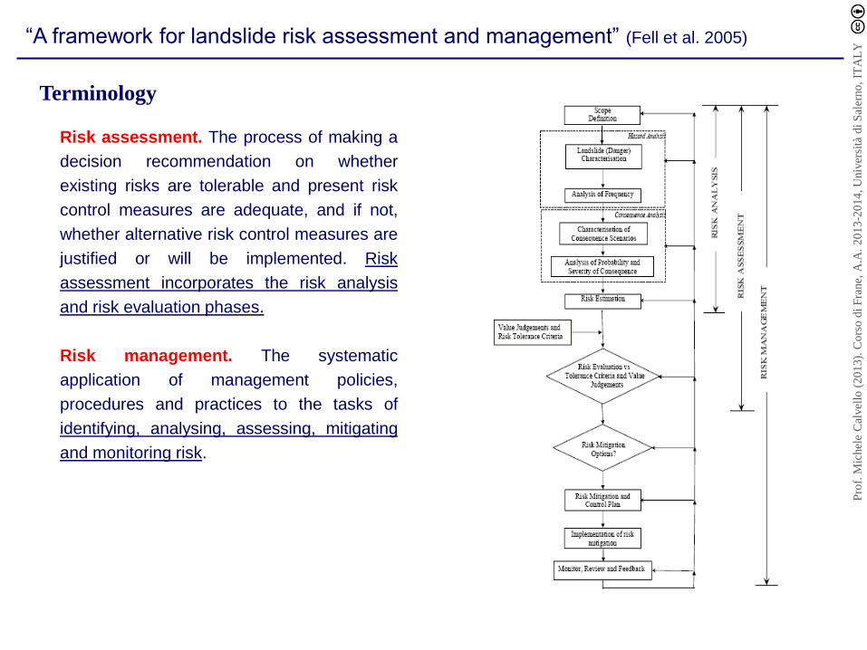
Risk assessment. The process of making a
decision recommendation on whether
existing risks are tolerable and present risk
control measures are adequate, and if not,
whether alternative risk control measures are
justified or will be implemented. Risk
assessment incorporates the risk analysis
and risk evaluation phases.
Risk management. The systematic
application of management policies,
procedures and practices to the tasks of
identifying, analysing, assessing, mitigating
and monitoring risk.
Pro
f. M
ichel
e C
alvel
lo (
20
13
). C
ors
o d
i F
rane,
A.A
. 2
01
3-2
01
4, U
niv
ersi
tà d
i S
aler
no
, IT
AL
Y

“A framework for landslide risk assessment and management” (Fell et al. 2005)
Landslide risk analysis
Scope definition
To ensure that the risk analysis addresses the relevant issues, satisfies the needs of those
concerned, and to avoid misunderstandings, it is important to define the scope of the risk
analysis.
Hazard analysis
1. Landslide (Danger) characterisation
2. Frequency analysis
There are several ways of calculating frequency (IUGS 1997):
(1) Historic data within the area of study, or areas with similar characteristics, e.g. geology,
geomorphology.
(2) Empirical methods based on correlations in accordance with slope instability ranking systems.
(3) Use of geomorphological evidence (coupled with historical data), or based on expert judgement.
(4) Relationship to the frequency and intensity of the triggering event, e.g. rainfall, earthquake.
(5) Direct assessment based on expert judgement, which may be undertaken with reference to a
conceptual model, e.g. use of a fault tree methodology.
(6) Modelling the primary variable, e.g. piezometric pressures versus the triggering event, coupled with
varying levels of knowledge of geometry and shear strength.
(7) Application of probabilistic methods, taking into account the uncertainty in slope geometry, shear
strength, failure mechanism, and piezometric pressures. This may be done either in a reliability framework,
or taking into account the frequency of failure (for example by considering pore pressures on a frequency
basis).
(8) Combinations of the above methods.
Pro
f. M
ichel
e C
alvel
lo (
20
13
). C
ors
o d
i F
rane,
A.A
. 2
01
3-2
01
4, U
niv
ersi
tà d
i S
aler
no
, IT
AL
Y

“A framework for landslide risk assessment and management” (Fell et al. 2005)
Landslide risk analysis
Scope definition
To ensure that the risk analysis addresses the relevant issues, satisfies the needs of those
concerned, and to avoid misunderstandings, it is important to define the scope of the risk
analysis.
The probability of the landslide reaching the element at risk (PT:L) depends on the relative location of the
element at risk and the landslide source, together with the path the landslide is likely to travel below the
source.
The temporal spatial probability (PS:T) is the probability that the element at risk is in the area affected by
the hazard at the time of its occurrence.
It is a conditional probability, given the landslide occurs and the element at risk is on or in the path of the
landslide (Vprop:T = vulnerability of the element at risk to the landslide event, VD:T = vulnerability of the
person to the landslide event).
Consequence analysis
1. Elements at risk
2. Probability of landslide reaching the element at risk (PT:L)
3. Temporal spatial probability (PS:T)
4. Vulnerability (Vprop:T and VD:T)
Pro
f. M
ichel
e C
alvel
lo (
20
13
). C
ors
o d
i F
rane,
A.A
. 2
01
3-2
01
4, U
niv
ersi
tà d
i S
aler
no
, IT
AL
Y

“A framework for landslide risk assessment and management” (Fell et al. 2005)
Landslide risk analysis
Risk estimation
Risk calculation
R(prop) = P(L) x P(T:L) x P(S:T) x V(prop:T) x E
Annual Risk for property (annual loss of property value)
P(LOL) = P(L) x P(T:L) x P(S:T) x V(D:T)
Annual probability that a particular person may lose his/her life
P(L) is the frequency of the landsliding
P(T:L) is the probability of the landslide reaching the element at risk
P(S:T) is the temporal spatial probability of the element at risk
V(prop,T) is the vulnerability of the element at risk to the landslide event
E is the element at risk (e.g. the value or net present value of the property)
V(D:T) is the vulnerability of the person to the landslide event
Pro
f. M
ichel
e C
alvel
lo (
20
13
). C
ors
o d
i F
rane,
A.A
. 2
01
3-2
01
4, U
niv
ersi
tà d
i S
aler
no
, IT
AL
Y

“A framework for landslide risk assessment and management” (Fell et al. 2005)
Landslide risk analysis
Risk estimation
Multiple landslide hazards
Uncertainty and sensitivity analysis
Qualitative risk estimation
R(prop) = i [ P(L) x P(T:L) x P(S:T) x V(prop:T) x E ]i
Pro
f. M
ichel
e C
alvel
lo (
20
13
). C
ors
o d
i F
rane,
A.A
. 2
01
3-2
01
4, U
niv
ersi
tà d
i S
aler
no
, IT
AL
Y

“A framework for landslide risk assessment and management” (Fell et al. 2005)
Landslide risk assessment
Property or financial loss
Annualised risk cost
Financial capability
Impact on corporate reputations
Indirect costs (e.g. loss of road access)
..
Loss of life
Individual risk to life
Societal risk (frequency versus number of deaths (known as f - N) or cumulative frequency versus
number of deaths (known as F - N) criteria)
Annualised potential loss of life
Cost per statistical life saved (when mitigation measures are being considered)
Pro
f. M
ichel
e C
alvel
lo (
20
13
). C
ors
o d
i F
rane,
A.A
. 2
01
3-2
01
4, U
niv
ersi
tà d
i S
aler
no
, IT
AL
Y

Risk acceptance criteria
Acceptable risk. A risk which everyone impacted is prepared to accept.
Tolerable Risk. A risk within a range that society can live with so as to secure certain net benefits.
Factors that affect an individual's attitude to acceptable or tolerable risk (Resources available to reduce the risk,
individual's commitment to the property, age and character, …)
General principles that can be applied when considering tolerable risk to loss of life criteria (IUGS 1997):
• The incremental risk from a hazard to an individual should not be significant compared to other risks to which
a person is exposed in everyday life.
• The incremental risk from a hazard should, wherever reasonably practicable, be reduced: “As Low As
Reasonably Practicable” (ALARP) principle should apply.
• Higher risks are likely to be tolerated for existing slopes than for planned projects, and for workers in
industries with hazardous slopes, e.g. mines, than for society as a whole.
“A framework for landslide risk assessment and management” (Fell et al. 2005)
Landslide risk assessment
Pro
f. M
ichel
e C
alvel
lo (
20
13
). C
ors
o d
i F
rane,
A.A
. 2
01
3-2
01
4, U
niv
ersi
tà d
i S
aler
no
, IT
AL
Y

The outcomes of the Risk Assessent will be either:
(a) The risks are tolerable, or even acceptable and no mitigation options need be considered
(b) The risks are intolerable, and risk mitigation options need to be considered.
“A framework for landslide risk assessment and management” (Fell et al. 2005)
Landslide risk management
The risk management process is iterative, requiring consideration of the risk mitigation options and the results of the
implementation of the mitigation measures and of the monitoring.
Examples of options for mitigation of risks for a slope or group of slopes:
Reduce the frequency of landsliding
Reduce the probability of the landslide reaching the element at risk
Reduce the temporal spatial probability of the element at risk
Avoid the risk
Transfer the risk
Postpone the decision if there is sufficient uncertainty (this would usually only be a temporary measure)
Pro
f. M
ichel
e C
alvel
lo (
20
13
). C
ors
o d
i F
rane,
A.A
. 2
01
3-2
01
4, U
niv
ersi
tà d
i S
aler
no
, IT
AL
Y
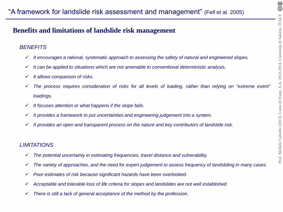
BENEFITS
It encourages a rational, systematic approach to assessing the safety of natural and engineered slopes.
It can be applied to situations which are not amenable to conventional deterministic analysis.
It allows comparison of risks.
The process requires consideration of risks for all levels of loading, rather than relying on "extreme event"
loadings.
It focuses attention or what happens if the slope fails.
It provides a framework to put uncertainties and engineering judgement into a system.
It provides an open and transparent process on the nature and key contributors of landslide risk.
LIMITATIONS
The potential uncertainty in estimating frequencies, travel distance and vulnerability.
The variety of approaches, and the need for expert judgement to assess frequency of landsliding in many cases.
Poor estimates of risk because significant hazards have been overlooked.
Acceptable and tolerable loss of life criteria for slopes and landslides are not well established.
There is still a lack of general acceptance of the method by the profession.
“A framework for landslide risk assessment and management” (Fell et al. 2005)
Benefits and limitations of landslide risk management
Pro
f. M
ichel
e C
alvel
lo (
20
13
). C
ors
o d
i F
rane,
A.A
. 2
01
3-2
01
4, U
niv
ersi
tà d
i S
aler
no
, IT
AL
Y

Risk analysis
Risk assessment
Risk management
Fell et al. (2005). A framework for landslide risk assessment and management. In: Landslide Risk Management, 3-25. ISBN-13: 978-0415380430.
Governo del territorio e “gestione del rischio da frana”
Pro
f. M
ichel
e C
alvel
lo (
20
13
). C
ors
o d
i F
rane,
A.A
. 2
01
3-2
01
4, U
niv
ersi
tà d
i S
aler
no
, IT
AL
Y
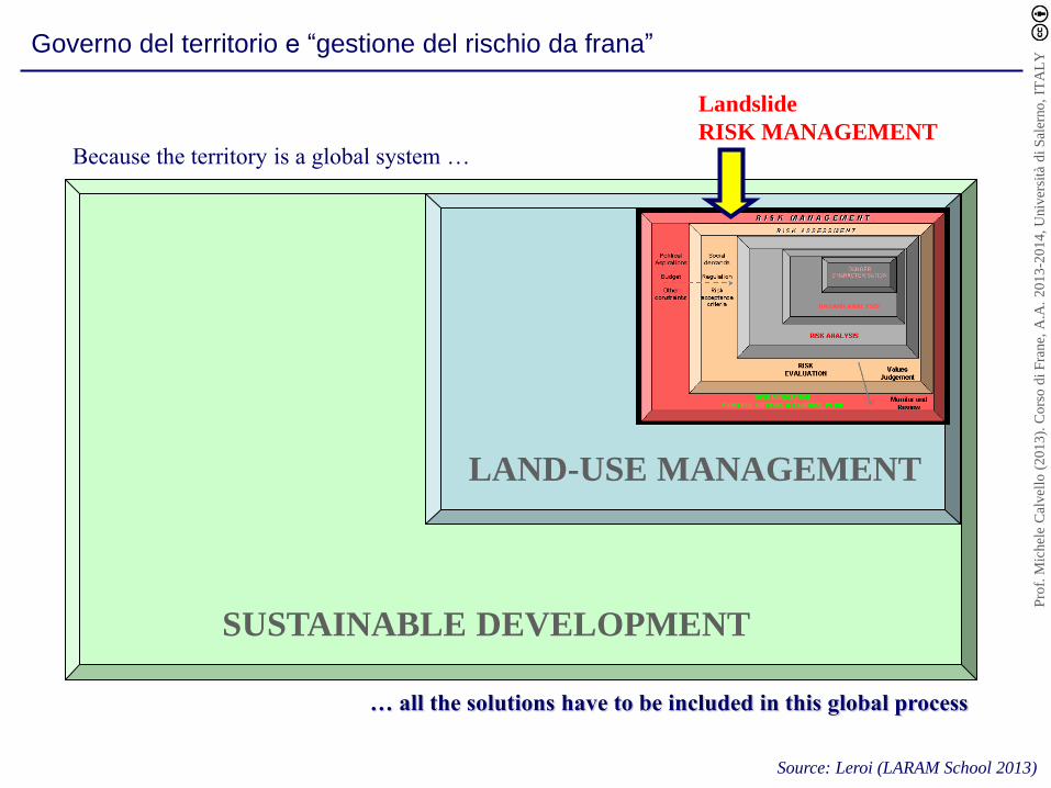
… all the solutions have to be included in this global process
LAND-USE MANAGEMENT
SUSTAINABLE DEVELOPMENT
Because the territory is a global system …
Landslide
RISK MANAGEMENT
Source: Leroi (LARAM School 2013)
Governo del territorio e “gestione del rischio da frana”
Pro
f. M
ichel
e C
alvel
lo (
20
13
). C
ors
o d
i F
rane,
A.A
. 2
01
3-2
01
4, U
niv
ersi
tà d
i S
aler
no
, IT
AL
Y

Source: Ammann, Global Risk Forum, Davos, 2009 (adapted from Leroi, LARAM School 2013)
Governo del territorio e “gestione del rischio da frana”
Pro
f. M
ichel
e C
alvel
lo (
20
13
). C
ors
o d
i F
rane,
A.A
. 2
01
3-2
01
4, U
niv
ersi
tà d
i S
aler
no
, IT
AL
Y

ISO 31000 (2009)
ISO 31000:2009 (2009). Risk management - Principles and guidelines. International Organization for Standardization, 24pp.
Risk no longer "chance or probability of loss” but "the effect of uncertainty on objectives”
Governo del territorio e “gestione del rischio da frana”
Pro
f. M
ichel
e C
alvel
lo (
20
13
). C
ors
o d
i F
rane,
A.A
. 2
01
3-2
01
4, U
niv
ersi
tà d
i S
aler
no
, IT
AL
Y