Ciaspole 2015 - Sauze Oulx
2
CIASPOLE OULX SAUZE D’OULX GRADO DEL PERICOLO DANGER LEVEL DEGRÉ DE DANGER ICONA ICON ICÔNE STABILITÀ DEL MANTO NEVOSO • SNOWPACK STABILITY STABILITÉ DU MANTEAU NEIGEUX PROBABILITÀ DI DISTACCO • AVALANCHE TRIGGERING PROBABILITY PROBABILITÉ DE DÉCLENCHEMENT 5 molto forte very high très fort Il manto nevoso è in generale debolmente consolidato e per lo più instabile. The snowpack is poorly bonded and largely unstable in general. L’instabilité du manteau neigeux est généralisée. Sono da aspearsi molte grandi valanghe spontanee, anche su terreno moderatamente ripido. Numerous large-sized and oſten very large-sized natural avalanches can be expected, even in moderately steep terrain. Spontanément, de nombreux départs de grosses, et parfois de très grosses avalanches sont à aeindre y compris en terrain peu raide. 4 forte high fort Il manto nevoso è debolmente consolidato sulla maggior parte dei pendii ripidi. The snowpack is poorly bonded on most steep slopes. Le manteau neigeux est faiblement stabilisé dans la plupart des pentes raides. Il distacco è probabile già con debole sovraccarico su mol pendii ripidi. In alcune situazioni sono da aspearsi molte valanghe spontanee di media grandezza, e talvolta anche grandi valanghe. Triggering is likely even from low addional loads on many steep slopes. In some cases, numerous medium-sized and oſten large-sized natural avalanches can be expected. Des déclenchements sont probables même par faible surcharge dans de nombreuses pentes raides. Dans certaines situaons, de nombreux départs spontanés d’avalanches de taille moyenne, et parfois grosse, sont à aeindre. 3 marcato considerable marqué Il manto nevoso presenta un consolidamento su mol pendii ripidi da moderato a debole. The snowpack is moderately to poorly bonded on many steep slopes. Le manteau neigeux n’est que modérément à faiblement stabilisé sur de nombreuses pentes raides. Il distacco è possibile con un debole sovraccarico soprauo sui pendii ripidi indica. In alcune situazioni sono possibili alcuni valanghe spontanee di media grandezza e in singoli casi anche grandi valanghe. Triggering is possible, even from low addional loads parcularly on the indicated steep slopes. In some cases medium-sized, in isolated cases large-sized natural avalanches are possible. Des déclenchements sont possibles parfois même par faible surcharge et surtout dans les pentes raides indiquées. Dans certaines situaons, quelques départs spontanés d’avalanches de taille moyenne, et parfois grosse, sont possibles. 2 moderato moderate limité Il manto nevoso è moderatamente consolidato su alcuni pendii ripidi, per il resto è ben consolidato. The snowpack is only moderately well bonded on some steep slopes, otherwise well bonded in general. Le manteau neigeux n’est que modérément stabilisé dans quelques pentes raides. Ailleurs, il est bien stabilisé. Il distacco è possibile soprauo con un forte sovraccarico sui pendii ripidi indica. Non sono da aspearsi grandi valanghe spontanee. Triggering is possible primarily from high addional loads, parcularly on the indicated steep slopes. Large-sized natural avalanches are unlikely. Des déclenchements sont possibles surtout par forte surcharge et dans les pentes raides indiquées. Des départs spontanés d’avalanches de grande ampleur ne sont pas à aeindre. 1 debole low faible Il manto nevoso è in generale ben consolidato e stabile. The snowpack is well bonded and stable in general. Le manteau neigeux est en général bien stabilisé. Il distacco è generalmente possibile soltanto con un forte sovraccarico su pochissimi pendii ripidi estremi. Sono possibili solo scaricamen e piccole valanghe spontanee. Triggering is generally possible only from high addional loads in isolated areas of very steep, extreme terrain. Only sluffs and small-sized natural avalanches are possible. Des déclenchements ne sont en général possibles que par forte surcharge dans des endroits isolées au terrain raide extrême. Seules des coulées et de petes avalanches peuvent se produire spontanément. Scala europea del pericolo valanghe con raccomandazioni European avalanche danger scale with recommendaons Echelle européenne de danger d’avalanche avec recommandaons Scegli tra gli inerari più diversi per localizzazione, difficoltà, lunghezza e non perdere l’occasione per provarli con gli innovavi KlimbSki. There’s a wide choice of ineraries of any kind, length and commitment. Do not miss the chance to try them with the new KlimbSki. Choisissez parmi des inéraires nombreux et différents, selon le lieu, la difficulté et la longueur. Ne perdez pas l’occasion de les essayer avec les innovants KlimbSki. SAUZE D’OULX Viale Genevris 7 +39.0122.858009 [email protected] Comune di Sauze d’Oulx PRIMA DI PARTIRE I percorsi indica sono ritenu sicuri in condizioni meteo e neve normali ma non sono sorveglia, pertanto, prima di intraprende una qualsiasi escursione, si consiglia di: • informarsi presso gli Uffici del Turismo, Scuole di Sci o Guide Alpine • consultare i bolleni meteo e valanghe di ARPA Piemonte all’indirizzo web www.arpa.piemonte.it/bolleni • scaricare le App gratuite BEFORE LEAVING The indicated walkways are to be considered safe only if weather and snow condions are normal and are not monitored. Therefore it is suggested, before doing any excursions, to: • ask for informaon by Tourism offices, Ski Schools or Mountain Guides • look at the weather and avalanche forecast of ARPA Piemonte at the following website www.arpa.piemonte.it/bolleni • download the free Apps AVANT DE PARTIR Les parcours indiqués sont sûrs quand il y a des condions météo et de neiges normales mais ils ne sont pas surveillés, donc il faut, avant de commercer la promenade: • s’informer chez les offices du tourisme, écoles de ski ou guides alpines • consulter la météo et le bullen avalanches de ARPA Piemonte à l’addresse suivante : www.arpa.piemonte.it/bolleni • téléchargez les Applis gratuites FlagMii Download from Windows Phone Store Meteo Vea REGOLAMENTO La variabilità delle condizioni ambientali può determinare una sensibile diminuzione del livello di sicurezza. In caso di marcato pericolo valanghe è sconsigliato intraprendere qualsiasi escursione. Indossare abbigliamento e calzature adegua all’ambiente montano invernale e portare con sé l’arezzatura per l’autosoccorso: ARVA, pala e sonda. Ulizzare la presente carna topografica e valutare prevenvamente la scelta dell’inerario; ogni persona dovrà scegliere gli inerari da percorrere in base alle proprie capacità tecniche e fisiche e alle arezzature disponibili. I traccia segnala vengono bau esclusivamente dal passaggio delle persone a piedi: non è previsto un servizio di manutenzione e batura meccanica, giornaliera o periodica. Per non disturbare la natura, per non perdere l’orientamento e per non correre il rischio di inciden, si raccomanda di seguire i percorsi e di rispeare scrupolosamente le zone adibite all’araversamento delle piste da sci rimanendo pruden, facendo notare la propria presenza e dando sempre la precedenza agli sciatori. Alcuni percorsi in quota sono facilmente raggiungibili ulizzando gli impian di risalita abilita al trasporto pedonale. Non geare rifiu nell’ambiente ma portarli con sé, raccogliendo eventualmente i rifiu lascia da altri. Lungo i percorsi sono a disposizione diversi pun di ristoro e pernoamento. I tempi di percorrenza indica sono tempi medi ed indicavi e possono variare considerevolmente in base alle condizioni della neve ed alle proprie capacità. Tu gli inerari sono percorribili in entrambe le direzioni di marcia. IN CASO DI EMERGENZA CHIAMARE IL Indicando con calma e precisione: • Chi sei • Cosa è successo • Luogo dell’incidente • Quando è successo • Quante persone sono state coinvolte e presenza di eventuali Soccorritori • Se in possesso di ARTVA o Recco • Indicazioni sulla morfologia del luogo e sulle condizioni meteo (uli per l’elisoccorso) Si declina ogni responsabilità per eventuali inciden che potrebbero verificarsi nel percorrere gli inerari e l’utente li transita a proprio rischio e pericolo RULES The change of the weather condions may cause a reducon of the safety level. In case of avalanche danger it’s not suggested to do any excursion. It’s suggested to wear winter mountain clothes and shoes and always bring a first aid kit: ARVA, shovel and drill. Use the following map and choose the inerary: each person will have to choose an inerary with reference to his/her own technical, physical abilies and the available equipment. The walkways are used only by people on foot: there is no mechanical maintenance service, neither daily nor periodically. In order not to disturb the nature, not to lose your bearings and to avoid accidents, it’s recommended to follow the walkways and pay aenon to the ski slope crossing areas, being careful, poinng out your presence and always giving way to the skiers. Some walkways are easily reachable using the ski tows. Do not throw waste away, keep them with you and pick up those leſt from other people. On the walkways there are several accommodaon places. Travelling mes are approximate and may change depending on snow condions and your own ability. All ineraries are walkable in both direcons. IN CASE OF EMERGENCY CALL First of all: keep calm! You need to give some crucial informaon: • Who you are • What happened • Where is the place of accident • When take place the accident • How many buried vicms and presence of any rescuers • If buried vicms have transceivers or Recco • weather and visibility at the place of the accident (useful for helicopter) The organizaon denies all liabilies for any accident that may occur on the walkways. All walkers undertake them on their own responsibility. REGLEMENT La variabilité des condions peut signifier une diminuon du niveau de sécurité. En cas de haut danger d’avalanches il est déconseillé de faire aucune promenade. On conseille de porter vêtements et chaussures pour la montagne en hiver et d’avoir toujours l’équipement pour le premier secours : ARVA, pelle et sonde. Ulisez cee carte et évaluez le choix de l’inéraire en avant ; chaque personne doit choisir les inéraires selon ses propres habilites techniques, physiques et équipement disponible. Les parcours sont ulisés seulement par les personnes à pied : il n’y a pas un services d’entreen. Pour ne pas déranger la nature, pour ne pas perdre l’orientaon et ne pas risquer des accidents, on recommande de suivre les parcours et de respecter les zones de passage des pistes de ski en étant prudent, meant en évidence sa propre présence et en donnant la priorité aux skieurs. Quelques parcours sont accessible avec les remontées mécaniques. Ne pas jeter ordures dans la nature mais les emporter er dans les cas en ramassant les ordures des autres. Pendant les parcours il y a plusieurs points de ravitaillement et hébergement signés sur la carte. Les temps des parcours sont seulement indicaves et peuvent varier selon les condions de la neige et les propres habilités. Tous les inéraires sont pracables dans les deux direcons. EN CAS D’URGENCE APPELER LE • Qui êtes-vous ? • Que c’est-il passé ? • Quel est le lieu de l’incident ? • Quand cela c’est produit ? • Combien de personnes ont été impliquées et y a-t-il des sauveteurs ? • Etes vous en possession de balises GPS exemple ARVA ou RECCO ? • Informaon sur la morphologie du lieu et sur les condions météorologiques (en cas de secours par hélicoptère) L’organisaon décline la responsabilité pour accidents qui pourrait falloir dans les inéraires ; l’usager y circule à son propre risque et danger. www.klimbski.com Comune di Oulx
-
Upload
turismotorino -
Category
Documents
-
view
213 -
download
0
description
Â
Transcript of Ciaspole 2015 - Sauze Oulx

CIASPOLEOULXSAUZE D’OULX
GRADO DEL PERICOLO DANGER LEVEL
DEGRÉ DE DANGER
ICONA ICON
ICÔNESTABILITÀ DEL MANTO NEVOSO • SNOWPACK STABILITY
STABILITÉ DU MANTEAU NEIGEUXPROBABILITÀ DI DISTACCO • AVALANCHE TRIGGERING PROBABILITY
PROBABILITÉ DE DÉCLENCHEMENT
5molto fortevery hightrès fort
Il manto nevoso è in generale debolmente consolidato e per lo più instabile. The snowpack is poorly bonded and largely unstable in general.L’instabilité du manteau neigeux est généralisée.
Sono da aspettarsi molte grandi valanghe spontanee, anche su terreno moderatamente ripido. Numerous large-sized and often very large-sized natural avalanches can be expected, even in moderately steep terrain. Spontanément, de nombreux départs de grosses, et parfois de très grosses avalanches sont à atteindre y compris en terrain peu raide.
4fortehigh fort
Il manto nevoso è debolmente consolidato sulla maggior parte dei pendii ripidi. The snowpack is poorly bonded on most steep slopes. Le manteau neigeux est faiblement stabilisé dans la plupart des pentes raides.
Il distacco è probabile già con debole sovraccarico su molti pendii ripidi. In alcune situazioni sono da aspettarsi molte valanghe spontanee di media grandezza, e talvolta anche grandi valanghe.Triggering is likely even from low additional loads on many steep slopes. In some cases, numerous medium-sized and often large-sized natural avalanches can be expected.Des déclenchements sont probables même par faible surcharge dans de nombreuses pentes raides. Dans certaines situations, de nombreux départs spontanés d’avalanches de taille moyenne, et parfois grosse, sont à atteindre.
3marcatoconsiderablemarqué
Il manto nevoso presenta un consolidamento su molti pendii ripidi da moderato a debole. The snowpack is moderately to poorly bonded on many steep slopes. Le manteau neigeux n’est que modérément à faiblement stabilisé sur de nombreuses pentes raides.
Il distacco è possibile con un debole sovraccarico soprattutto sui pendii ripidi indicati. In alcune situazioni sono possibili alcuni valanghe spontanee di media grandezza e in singoli casi anche grandi valanghe. Triggering is possible, even from low additional loads particularly on the indicated steep slopes. In some cases medium-sized, in isolated cases large-sized natural avalanches are possible. Des déclenchements sont possibles parfois même par faible surcharge et surtout dans les pentes raides indiquées. Dans certaines situations, quelques départs spontanés d’avalanches de taille moyenne, et parfois grosse, sont possibles.
2moderatomoderatelimité
Il manto nevoso è moderatamente consolidato su alcuni pendii ripidi, per il resto è ben consolidato. The snowpack is only moderately well bonded on some steep slopes, otherwise well bonded in general. Le manteau neigeux n’est que modérément stabilisé dans quelques pentes raides. Ailleurs, il est bien stabilisé.
Il distacco è possibile soprattutto con un forte sovraccarico sui pendii ripidi indicati. Non sono da aspettarsi grandi valanghe spontanee.Triggering is possible primarily from high additional loads, particularly on the indicated steep slopes. Large-sized natural avalanches are unlikely.Des déclenchements sont possibles surtout par forte surcharge et dans les pentes raides indiquées. Des départs spontanés d’avalanches de grande ampleur ne sont pas à atteindre.
1debolelowfaible
Il manto nevoso è in generale ben consolidato e stabile.The snowpack is well bonded and stable in general.Le manteau neigeux est en général bien stabilisé.
Il distacco è generalmente possibile soltanto con un forte sovraccarico su pochissimi pendii ripidi estremi. Sono possibili solo scaricamenti e piccole valanghe spontanee.Triggering is generally possible only from high additional loads in isolated areas of very steep, extreme terrain. Only sluffs and small-sized natural avalanches are possible.Des déclenchements ne sont en général possibles que par forte surcharge dans des endroits isolées au terrain raide extrême. Seules des coulées et de petites avalanches peuvent se produire spontanément.
Scala europea del pericolo valanghe con raccomandazioni European avalanche danger scale with recommendations Echelle européenne de danger d’avalanche avec recommandations
Scegli tra gli itinerari più diversi per localizzazione, difficoltà, lunghezza e non perdere l’occasione per provarli con gli innovativi
KlimbSki.
There’s a wide choice of itineraries of any kind, length
and commitment. Do not miss the chance to try them with the
new KlimbSki.
Choisissez parmi des itinéraires nombreux et différents, selon le lieu, la difficulté et la longueur. Ne perdez pas l’occasion de les essayer avec les innovants KlimbSki.
SAUZE D’OULXViale Genevris 7
Comune di Sauze d’Oulx
PRIMA DI PARTIREI percorsi indicati sono ritenuti sicuri in condizioni meteo e neve normali ma non sono sorvegliati, pertanto, prima di intraprende una qualsiasi escursione, si consiglia di:• informarsi presso gli Uffici del Turismo, Scuole di Sci o Guide Alpine• consultare i bollettini meteo e valanghe di ARPA Piemonte all’indirizzo web www.arpa.piemonte.it/bollettini• scaricare le App gratuite BEFORE LEAVINGThe indicated walkways are to be considered safe only if weather and snow conditions are normal and are not monitored. Therefore it is suggested, before doing any excursions, to:• ask for information by Tourism offices, Ski Schools or Mountain Guides • look at the weather and avalanche forecast of ARPA Piemonte at the following website www.arpa.piemonte.it/bollettini • download the free AppsAVANT DE PARTIRLes parcours indiqués sont sûrs quand il y a des conditions météo et de neiges normales mais ils ne sont pas surveillés, donc il faut, avant de commercer la promenade:• s’informer chez les offices du tourisme, écoles de ski ou guides alpines• consulter la météo et le bulletin avalanches de ARPA Piemonte à l’addresse suivante : www.arpa.piemonte.it/bollettini• téléchargez les Applis gratuites
FlagMiiDownload fromWindows Phone Store
Meteo Vetta
REGOLAMENTOLa variabilità delle condizioni ambientali può determinare una sensibile diminuzione del livello di sicurezza. In caso di marcato pericolo valanghe è sconsigliato intraprendere qualsiasi escursione.Indossare abbigliamento e calzature adeguati all’ambiente montano invernale e portare con sé l’attrezzatura per l’autosoccorso: ARVA, pala e sonda.Utilizzare la presente cartina topografica e valutare preventivamente la scelta dell’itinerario; ogni persona dovrà scegliere gli itinerari da percorrere in base alle proprie capacità tecniche e fisiche e alle attrezzature disponibili.I tracciati segnalati vengono battuti esclusivamente dal passaggio delle persone a piedi: non è previsto un servizio di manutenzione e battitura meccanica, giornaliera o periodica.Per non disturbare la natura, per non perdere l’orientamento e per non correre il rischio di incidenti, si raccomanda di seguire i percorsi e di rispettare scrupolosamente le zone adibite all’attraversamento delle piste da sci rimanendo prudenti, facendo notare la propria presenza e dando sempre la precedenza agli sciatori.Alcuni percorsi in quota sono facilmente raggiungibili utilizzando gli impianti di risalita abilitati al trasporto pedonale.Non gettare rifiuti nell’ambiente ma portarli con sé, raccogliendo eventualmente i rifiuti lasciati da altri.Lungo i percorsi sono a disposizione diversi punti di ristoro e pernottamento.I tempi di percorrenza indicati sono tempi medi ed indicativi e possono variare considerevolmente in base alle condizioni della neve ed alle proprie capacità.Tutti gli itinerari sono percorribili in entrambe le direzioni di marcia.
IN CASO DI EMERGENzA ChIAMARE ILIndicando con calma e precisione:• Chi sei• Cosa è successo• Luogo dell’incidente• Quando è successo• Quante persone sono state coinvolte e presenza di eventuali Soccorritori• Se in possesso di ARTVA o Recco• Indicazioni sulla morfologia del luogo e sulle condizioni meteo (utili per l’elisoccorso)
Si declina ogni responsabilità per eventuali incidenti che potrebbero verificarsi nel percorrere gli itinerari e l’utente li transita a proprio rischio e pericolo
RULESThe change of the weather conditions may cause a reduction of the safety level. In case of avalanche danger it’s not suggested to do any excursion.It’s suggested to wear winter mountain clothes and shoes and
always bring a first aid kit: ARVA, shovel and drill.Use the following map and choose the itinerary: each person will have to choose an itinerary with reference to his/her own technical, physical abilities and the available equipment.The walkways are used only by people on foot: there is no mechanical maintenance service, neither daily nor periodically.In order not to disturb the nature, not to lose your bearings and to avoid accidents, it’s recommended to follow the walkways and pay attention to the ski slope crossing areas, being careful, pointing out your presence and always giving way to the skiers.Some walkways are easily reachable using the ski tows.Do not throw waste away, keep them with you and pick up those left from other people.On the walkways there are several accommodation places.Travelling times are approximate and may change depending on snow conditions and your own ability.All itineraries are walkable in both directions.
IN CASE OF EMERGENCY CALLFirst of all: keep calm! You need to give some crucial information:• Who you are• What happened• Where is the place of accident • When take place the accident• How many buried victims and presence of any rescuers• If buried victims have transceivers or Recco• weather and visibility at the place of the accident (useful for helicopter)
The organization denies all liabilities for any accident that may occur on the walkways. All walkers undertake them on their own responsibility.
REGLEMENTLa variabilité des conditions peut signifier une diminution du niveau de sécurité. En cas de haut danger d’avalanches il est déconseillé de faire aucune promenade.On conseille de porter vêtements et chaussures pour la montagne en hiver et d’avoir toujours l’équipement pour le premier secours : ARVA, pelle et sonde.Utilisez cette carte et évaluez le choix de l’itinéraire en avant ; chaque personne doit choisir les itinéraires selon ses propres habilites techniques, physiques et équipement disponible.Les parcours sont utilisés seulement par les personnes à pied : il n’y a pas un services d’entretien.Pour ne pas déranger la nature, pour ne pas perdre l’orientation et ne pas risquer des accidents, on recommande de suivre les parcours et de respecter les zones de passage des pistes de ski en étant prudent, mettant en évidence sa propre présence et en
donnant la priorité aux skieurs.Quelques parcours sont accessible avec les remontées mécaniques.Ne pas jeter ordures dans la nature mais les emporter er dans les cas en ramassant les ordures des autres.Pendant les parcours il y a plusieurs points de ravitaillement et hébergement signés sur la carte.Les temps des parcours sont seulement indicatives et peuvent varier selon les conditions de la neige et les propres habilités.Tous les itinéraires sont praticables dans les deux directions.
EN CAS D’URGENCE APPELER LE • Qui êtes-vous ? • Que c’est-il passé ?• Quel est le lieu de l’incident ?• Quand cela c’est produit ?• Combien de personnes ont été impliquées et y a-t-il des sauveteurs ?• Etes vous en possession de balises GPS exemple ARVA ou RECCO ?• Information sur la morphologie du lieu et sur les conditions météorologiques (en cas de secours par hélicoptère)
L’organisation décline la responsabilité pour accidents qui pourrait falloir dans les itinéraires ; l’usager y circule à son propre risque et danger.
www.klimbski.com
Comune di Oulx
19
9
11
2
4
5
5
3
1
1
3
2
2
3
3
3
Alp
eG
aggi
era
Clo
tBou
rget
LeC
lote
s Cap
anni
naK
ind
Pia
nde
llaR
occa
Bel
vede
reB
unke
r
Torb
iera
Cas
eS
oube
iran
Faro
degl
iA
lpin
i
Cas
eLa
mpu
iè
Istit
uto
Zoot
ecni
coR
icha
rdet
te
Gra
nV
illar
d
C.E
nfer
sA
lpe
diLa
uneGr.R
andu
in
C.R
ival
C.s
eS
ersa
ret
C.E
tanc
he
C.Q
uin
C.B
uiss
oniè
re
Rif.
D.A
rlaud
Bar
riera
Sal
bertr
and
Bun
ker
Font
ana
delF
anjaC
.Cro
s
Bel
vede
reS
elle
tte
Cro
ceG
hiot
ti
Bun
ker
Rif.
Cia
oP
ais
Cap
pella
Cha
mpa
rey
San
taM
adda
lena
Chi
esa
Pon
tVen
toux
San
taM
aria
delR
osar
io
Mal
afos
seB
assa
Col
onia
Lanc
ia
C.F
oung
illar
de
Sar
nas
Abb
azia
Mor
etta
Aub
erge
-Inf.e
-diM
ezzo
-Sup
.e
LaV
illet
ta
Pon
tV
ento
ux
C.P
lans
Cim
itero
Cim
itero
S.D
omen
ico
Gro
ttade
llaB
eaum
e
Cas
erm
e
Dig
aP
ontV
ento
ux
C.C
lape
rias
Cav
adi
piet
ra
Font
ana
Sug
u
Tach
ier
San
Lore
nzo
Cas
cate
Spo
rtini
a
Mon
tagn
eS
eu
Mon
fol
Gad
San
Mar
co
Jouv
ence
aux
Bor
goB
asso
Bor
goA
lto
2108
2507
2467
230922
86
2082
1901
1619
2093
2072
2073
1861
1738
2470
2287
2320
2484
2061
2287
2364
2319
1757
1931
1933
1866
1973
2299
2145
2246
2003
2243
2297
1958
2140
2409
2404
2266
2379
2312
1507
1520
2512
2418
1949
1681
1834
2083
2053
1797
1279
1451
1662
1794
1819
2275
2261
2263
2281
1497
2301
1716
2533
2192
2169
2059
1870
2545
2520
2115
1764 17
76
1824
1313
1452
1495
1599
1372
1510
1308
1270
1793
1760
1043
1028
1025
1121
1122
1587
1709
1728
1800
1047
1062
1064
1054
1171
1136
1560
1510
1486
1429
1373
1339
1387
1072
1290
1058
1402
1212
1265
1327
1186
1114
1304
1078
1168
1271
1051
1064
1081
1054
1776
1671
1561
1563
2092
1911
1913
1462
1305
1204
164715
38
1102
1271
1114
1344
1112
1098
1061
1793
1654
1418
1324
1046
1110
1228
1184
1037
1172
1043
1435
1305
1465
1549
1161
Chevalina
Bos
cola
Sella Bois
des
Abea
ux
Mia
ndet
te
Serradel Crine
Bosc
oTa
glia
te
Bos
coPi
netd
uM
onfo
l
Bosc
oIn
vers
diM
alaf
osse
Clot
Juan
a
Prat
ode
llaN
otte
S.S.24
Frum
entin
e-G
arai
Bosco Ser
rela
Garde
S.S.
335
R. S
agna
R. C
ham
pR
ober
tR. D
onna
Mar
ia
Com
badi
Mon
cron
s
R. C
lote
s
Rio
Gra
nC
omba
l
R. dell
'Ann
etta
R.Ourettes
R.P
lene
i
R. G
orge
Lago
diLa
une
Lago
Pon
tVen
toux
RioLu
cias
R. San
Mar
co
RioM
oret
ta
Rio Gran Comba
RioBar
raca
n
Rio Segouret
M.G
enev
ris
Col
leC
osta
Pia
na
Col
leB
ourg
et
Pun
taM
oncr
ons
Col
leB
legi
er
Ser
reG
ount
ard
Gran
Bosc
o
.
..
..
.
.
..
.
.
.
..
..
.
..
.
.
.
..
.
.
..
.
.
.
..
.
.
.
..
.
.
.
.. .
.
.
.
.
..
.
.
.
.
.
..
..
.
. .
.
.
.
.
..
.
.
.
.
.
.
.
.
.
.
.
.
.
.
.
.
.
.
...
.
..
.
.
.
.
.
.
.
.
..
.
.
.
.
.
.
.
.
.
.
.
.
.
.
.
.
.
.
. .
.
.
.
.
.
.
.
.
.
.
.
.
.
.
.
)(
)(
)(
1600
1700
18001900
2000
2100
2200
1300
1200
1400
1600
1700
1900
2000
2000
2100
2200
2300
2400
1900
1800
1700
1600
15001400
1400
1500
1300
Cart
ogra
fia re
alizz
ata
da F
RATE
RNAL
I EDI
TORE
, ba
sata
sulla
Car
ta Te
cnic
a Re
gion
ale
Vect
or 1
0 in
scal
a 1:
1000
0 de
lla R
egio
ne
Piem
onte
(edi
zione
199
1 –
2005
)
ITIN
ER
AR
I IT
INE
RA
RIE
S •
ITIN
ER
AIR
ES
LEG
ENDA
• L
EGEN
D •
LEG
ENDE
Faci
le •
Eas
y •
Faci
le
Med
io-fa
cile
• M
ediu
m-E
asy
• M
oyen
faci
le
Med
io •
Med
ium
• M
oyen
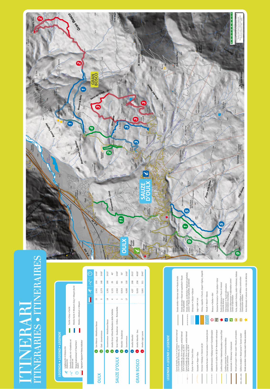
OULX
9Sa
n M
arco
- M
alaf
osse
Bas
sa15
2,56
125
01h
30’
11Ga
d - J
ouve
ncea
ux9
2,27
314
81h
30’
SAUZ
E D’
OULX
1Jo
uven
ceau
x - M
alaf
osse
Bas
sa14
1,39
119
01h
15’
2An
ello
Gra
n Vi
llard
Bel
vede
re d
elle
Sel
lette
41,
121
2040
’
3Gr
an V
illar
d - S
oube
iran
- Enf
ers -
Ric
hard
ette
12,
562
301
1h30
’
4M
onfo
l - S
oube
iran
20,
914
5050
’
5Jo
uven
ceau
x17
4,00
013
01h
30’
GRAN
BOS
CO1
Anel
lo M
onfo
l4,
9720
82h
15’
2An
ello
Mon
fol -
Seu
9,43
525
84h
30’
3An
ello
Lag
o La
une
5,66
131
12h
45’
LEG
ENDA
• L
EGEN
D •
LEG
ENDE
Curv
a di
livel
lo, e
q. 5
m •
Con
tour
s, ve
rtica
l inte
rval
5
m •
Cou
rbe d
e nive
au, e
q. 5
mCu
rva d
i live
llo, e
q. 10
m •
Cont
ours,
verti
cal in
terv
al
10 m
• Co
urbe
de ni
veau
, eq.
10 m
Curv
a di li
vello
, eq.
50 m
• C
onto
urs,
verti
cal in
terv
al
50 m
• Co
urbe
de ni
veau
, eq.
50 m
Fium
e •
Rive
r • C
ours
d’ea
u
Scar
pata
• Sl
ope
• Ta
lus
Ferro
via •
Rai
lway
• C
hem
in d
e fe
r
Cond
otta f
orza
ta •
Forc
ed co
nduc
t • C
ondu
ite fo
rcée
Galle
ria fe
rrovia
ria •
Railw
ay tu
nnel
• Tu
nnel
ferro
viaire
Impi
anto
di r
isalit
a •
Ski li
ft •
Rem
onté
e m
écan
ique
Confi
ne d
i Sta
to •
Nati
onal
bou
ndar
y • Li
mite
d’E
tat
Confi
ne co
mun
ale
• Co
mm
unal
bou
ndar
y Lim
ite d
e com
mun
e
Auto
stra
da •
Mot
orw
ay •
Aut
orou
te
Stra
de p
rincip
ali •
Mai
n ro
ads •
Rou
tes p
rincip
ales
Galle
ria st
rada
le •
Roa
d tu
nnel
• Tu
nnel
routi
er
Strad
e sec
onda
rie •
Seco
ndar
y roa
ds •
Rout
es se
cond
aires
Stra
da st
retta
• N
arro
w ro
ad •
Rou
te ét
roite
Stra
da st
erra
ta •
Roa
d no
t asp
halte
d •
Rout
e no
n as
phal
tée
Stra
da st
erra
ta, a
ccid
enta
ta •
Roa
d no
t asp
halte
d,
unev
en •
Rou
te n
on a
spha
ltée,
acc
iden
tée
Ghia
ccia
io •
Gla
cier •
Gla
cier
Lago
• La
ke •
Lac
Chie
sa, c
appe
lla •
Chu
rch,
chap
el •
Églis
e, ch
apel
le
Palu
de •
Mar
sh •
Mar
ais
Biva
cco
• Sh
elte
r • A
bri
Staz
ione
ferro
viaria
• Tr
ain
statio
n •
Gare
Punt
o di
inte
ress
e •
Plac
e of
inte
rest
Cu
riosit
è di
vers
eIn
form
azio
ni •
Tour
ist in
form
ation
sIn
form
ation
s tou
ristiq
ues
Cent
ro in
form
azio
ni •
Info
rmati
on ce
ntre
Ce
ntre
d’in
form
ation
Forte
, cas
tello
• Fo
rtres
s, ca
stle •
Forte
ress
e, ch
atea
u
Cost
ruzio
ne m
ilitar
e •
Milit
ary c
onst
ructi
on
Cons
tructi
on m
ilitai
re
Area
Attr
ezza
ta •
Leisu
re a
rea
• Ai
re d
e dé
tent
e
900
900
SAU
zED
’OU
LX
OU
LX
GRA
N
BOSC
O
Lung
hezz
a Km
• D
istan
ce Km
Dista
nce K
m
Disli
vello
in sa
lita
mt •
Gra
dien
ts m
t Dé
nive
lé m
t
Tem
po di
perco
rrenz
a h •
Trave
l tim
e h
Duré
e h
Segn
avia
• Sign
post
• Pot
eau i
ndica
teur