12 Jeobeyond-elastic in a day 2016 - Seacom - Zimbra - … · · 2016-06-21•Gli...
27
Elastic Stack in A Day Milano – 16 Giugno 2016 OpenGeo Suite e Elasticsearch
Transcript of 12 Jeobeyond-elastic in a day 2016 - Seacom - Zimbra - … · · 2016-06-21•Gli...

Elastic Stack in A DayMilano – 16 Giugno 2016
OpenGeo Suite e Elasticsearch

• COSA E’ LA OPENGEO SUITE• COMPONENTE SPATIAL DI ELASTICSEARCH• ELASTICSEARCH COME BACKEND DI GEOSERVER• DATA FUSION IN UN WEBGIS• Q/A
Agenda

• STARTUP INNOVATIVA nata nel 2011• SISTEMI INFORMATIVI GEOGRAFICI• SISTEMI DI IDENTITY & ACCESS MANAGEMENT
• PARTNER BOUNDLESS SPATIAL INC.• SOCIO FONDATORE RIOS (Rete Italiana Open Source Professionale)

• Gli asset aziendali/amministrativi sono fonteprimaria di informazionigeografiche
• In media ≈80% delle informazioni residentinei database sono correlate a dati con caratteristiche geografiche
• Trend di crescita esponenziale (Smart Cities, IoT, Big Data)
INFORMAZIONE GEOGRAFICA
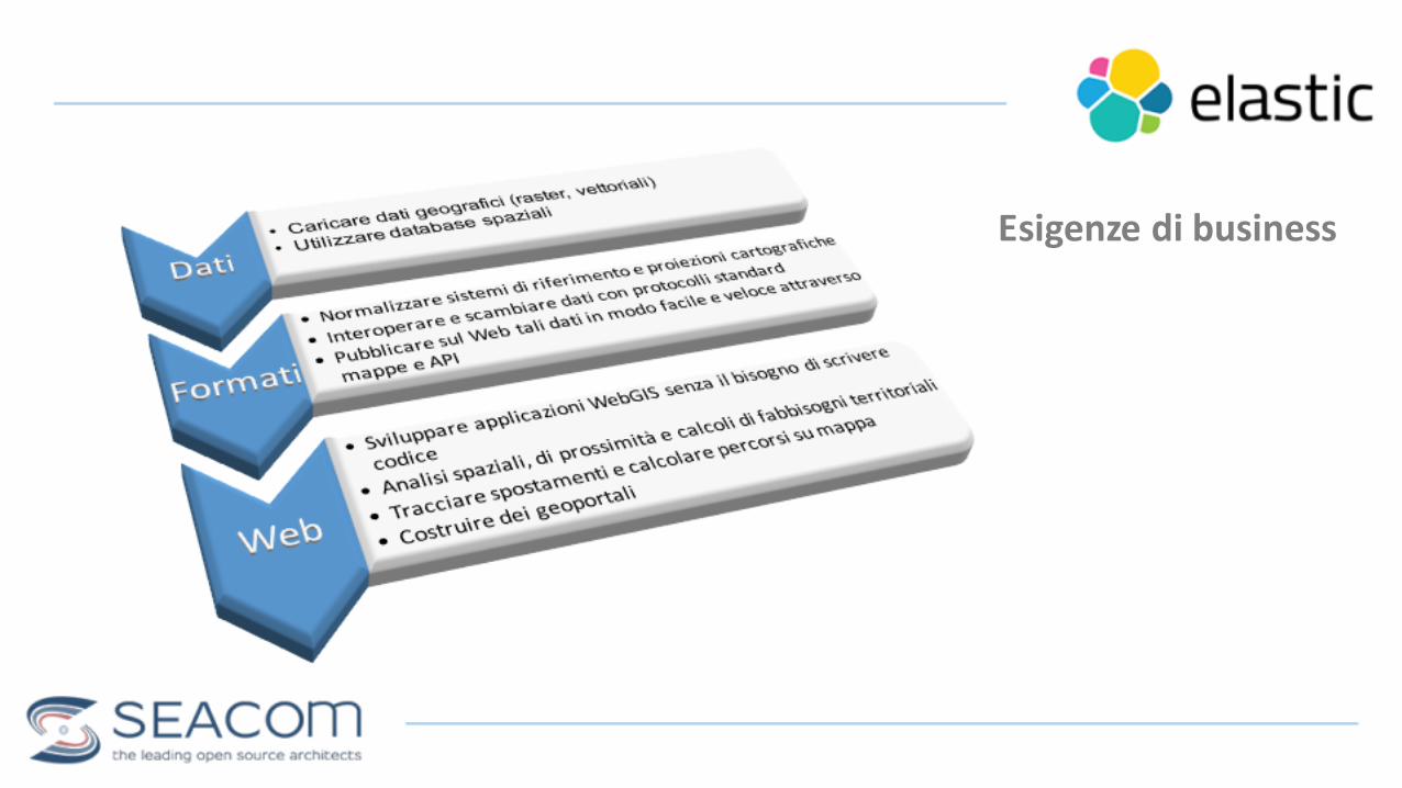
Esigenze di business

• Ecosistema di componenti open source• GeoExt/OpenLayers• GeoWebCache• GeoServer• PostGIS• GeoGig• QGIS
OPENGEO SUITE

L’ALTERNATIVA OPEN

L’ALTERNATIVA OPEN

• SoluzioneGIS completa• Versione Community e Enterprise (≠ supporto)• Pronta all’uso e facile da usare• Basata su servizi SOA e REST• Aderente agli standard di settore OGC e INSPIRE• Flessibile, modulare e interoperabile• Integrata out-‐of-‐the-‐box con OpenStreetMap• Integra connettori plug&playad altri backend di terzeparti
CARATTERISTICHE

ARCHITETTURA
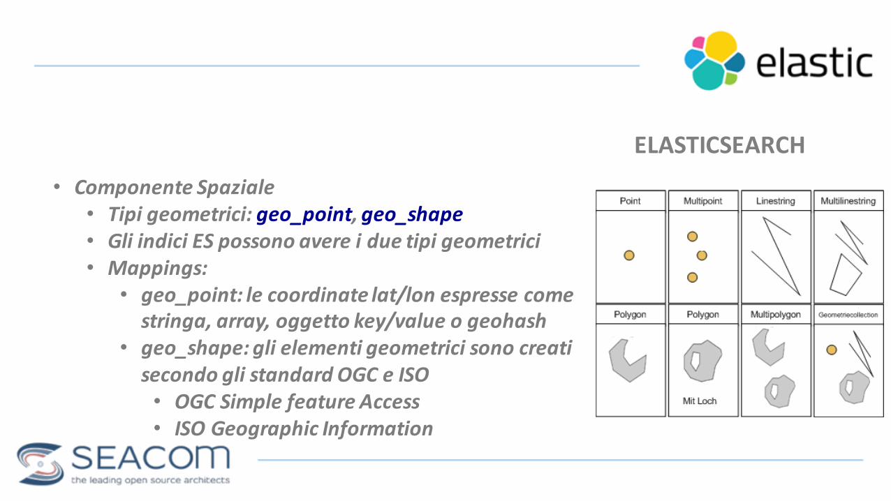
• Componente Spaziale• Tipi geometrici: geo_point, geo_shape• Gli indici ES possono avere i due tipi geometrici• Mappings:
• geo_point: le coordinate lat/lon espresse come stringa, array, oggetto key/value o geohash
• geo_shape: gli elementi geometrici sono creatisecondo gli standard OGC e ISO• OGC Simple feature Access• ISO Geographic Information
ELASTICSEARCH

POST public/incidents { “location” : { “lat” : 41.12, “lon” : -‐71.34 } } alternativamentePOST public/incidents { “location” : “41.12, -‐71.34” }POST public/incidents { “location” : [ [-‐71.34, 41.12], [ -‐71.34, 41.21]]}
Mappings GEO_POINT

PUT public/schools/ {
“geometry” : {“type” : “polygon”,“coordinates” : [[
[40.7538588, -‐73.9762134], [40.7526327, -‐73.9742356], [40.7516774, -‐73.9656733], [40.7521246, -‐73.9763236], [40.7516733, -‐73.9723788], [40.7523556, -‐73.9732423], [40.7538588, -‐73.9762134]
]]}
}
Mappings GEO_SHAPE

$ ogr2ogr -‐progress -‐lco INDEX_NAME=elasticday -‐lco MAPPING_NAME=mfermate-‐lco FID=ID -‐lco GEOMETRY_NAME=geometry -‐lcoGEOM_MAPPING_TYPE=GEO_POINT -‐s_srs EPSG:32632 -‐t_srs EPSG:4326 -‐f "ElasticSearch" http://localhost:9200 MM_FERM.shp
Caricamento dati
• Portale Open Data Milano• Shapefiles dei trasporti: http://dati.comune.milano.it/• Attenzione con il sistema di riferimento!!!
• GDAL rescue!!!• Conversione al volo e caricamento con il driver ELASTICSEARCH

• Connettore Elasticsearch ELASTICGEO• Datastore di GeoServer• Un indiceES è pubblicato come layer di GeoServer• Supporta i mappings dei tipi geo_point e geo_shape• I filtri OGC sono convertiti in filtri ES nelle chiamateWMS e WFS
• Compatibilità:• Java SDK (>=1.7)• GeoServer 2.7.x+ e Elasticsearch 1.4.x+
GEOSERVER PLUGIN

• Build del plugin:
INSTALLAZIONE• Build del plugin:
$ git clone https://github.com/geobeyond/elasticgeo.git
$ git checkout 2.8-‐SNAPSHOT
$ mvn clean install
$ cd gs-‐web-‐elasticsearch && mvn package -‐P deploy
• Installazione:$ cp target/elasticgeo2.8-‐SNAPSHOT-‐gs2.8-‐SNAPSHOT-‐
es2.2.2.jar webapps/geoserver/WEB-‐INF/lib$ cp guava-‐18.0.jar webapps/geoserver/WEB-‐INF/lib
• Necessario:
• Connettore ES
• Libreria Guava 1.8

AVVIO OPENGEO SUITE
• http://localhost:8080/dashboard
• DASHBOARD per l’accessoai componenti
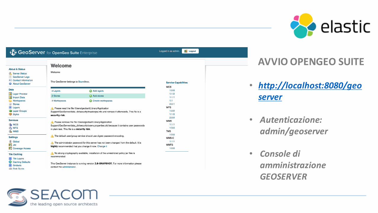
AVVIO OPENGEO SUITE
• http://localhost:8080/geoserver
• Autenticazione: admin/geoserver
• Console di amministrazioneGEOSERVER

ELASTICGEO DATASTORE
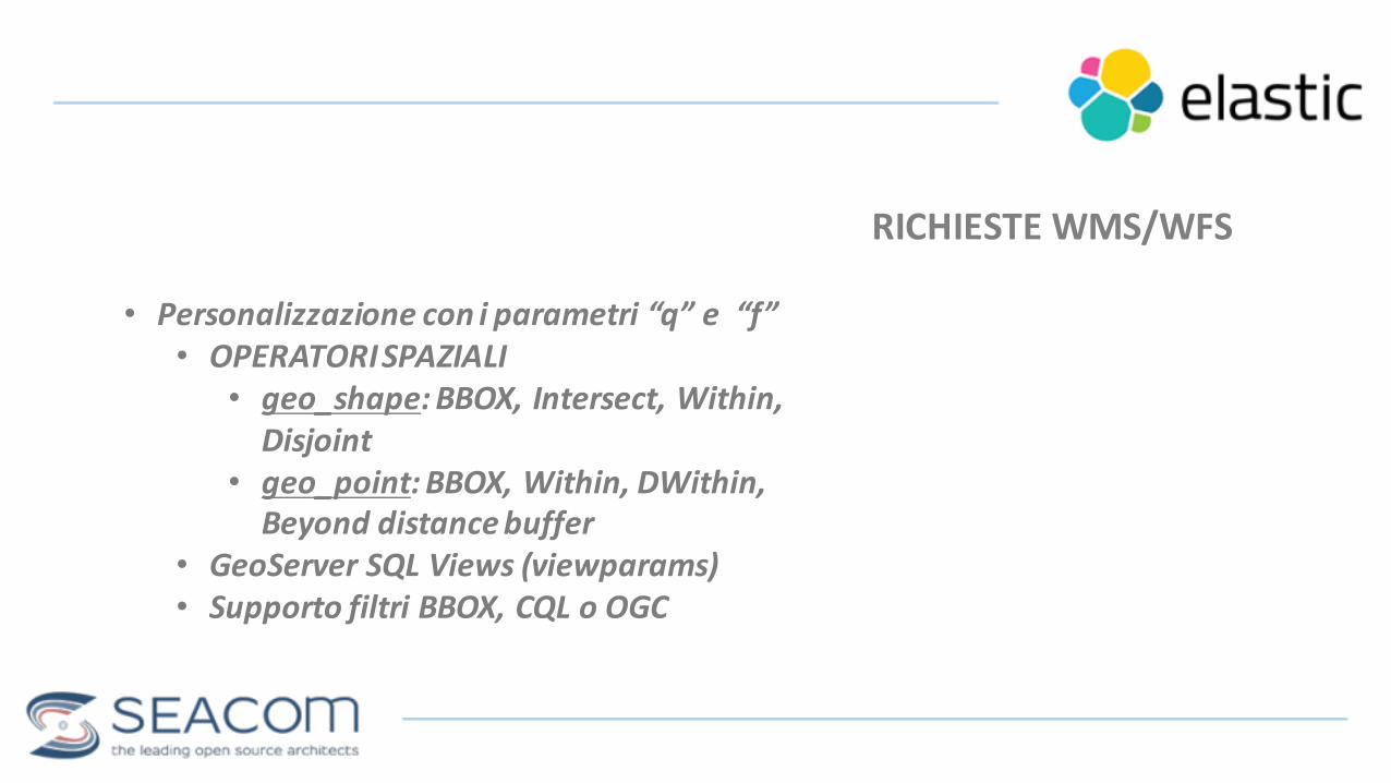
RICHIESTE WMS/WFS
• Personalizzazione con i parametri “q” e “f”• OPERATORI SPAZIALI• geo_shape: BBOX, Intersect, Within, Disjoint
• geo_point: BBOX, Within, DWithin, Beyond distance buffer
• GeoServer SQL Views (viewparams)• Supporto filtri BBOX, CQL o OGC

RICHIESTE WMS/WFSFILTRO BBOX e CQL
http://localhost:8080/geoserver/elasticday/wms?service=WMS&version=1.1.0&request=GetMap&layers=elasticday:park_pub_4326&styles=&bbox=-‐1,-‐1,10,10&width=279&height=512&srs=EPSG:4326&format=application/openlayers&cql_filter=indirizzo='Piazza Giulio Cesare'
UNA MAPPA DI UN TIPO DI DATO NELL’INDICE ELASTICSEARCH!!!
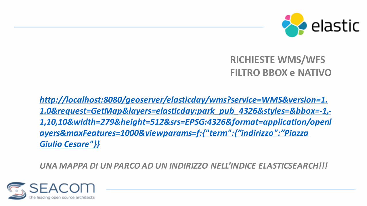
RICHIESTE WMS/WFSFILTRO BBOX e NATIVO
http://localhost:8080/geoserver/elasticday/wms?service=WMS&version=1.1.0&request=GetMap&layers=elasticday:park_pub_4326&styles=&bbox=-‐1,-‐1,10,10&width=279&height=512&srs=EPSG:4326&format=application/openlayers&maxFeatures=1000&viewparams=f:{"term":{”indirizzo":”Piazza Giulio Cesare"}}
UNA MAPPA DI UN PARCO AD UN INDIRIZZO NELL’INDICE ELASTICSEARCH!!!

• HTML? JAVASCRIPT? NODEJS? PYTHON? JAVA??• QGIS INVECE!!!• BOUNDLESS PLUGINS
• GEOSERVER EXPLORER• Utility di configurazionedi workspace, layer e stilinel catalogodi GeoServer
• WEB APP BUILDER• Costruttore automaticodi applicazioniWebGisbasate su OpenLayers 3 a partire dai layer caricatidal catalogodi GeoServer
UN WEBGIS ALLORA?
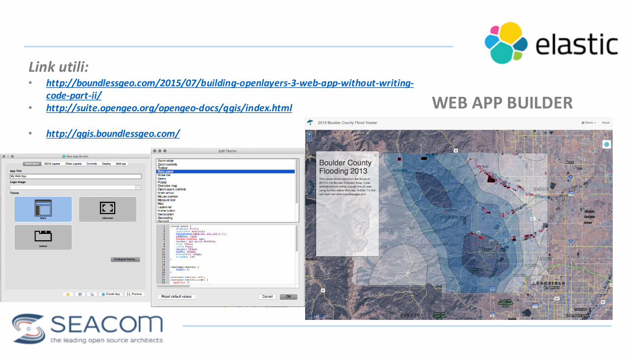
WEB APP BUILDER
Link utili:• http://boundlessgeo.com/2015/07/building-‐openlayers-‐3-‐web-‐app-‐without-‐writing-‐
code-‐part-‐ii/• http://suite.opengeo.org/opengeo-‐docs/qgis/index.html
• http://qgis.boundlessgeo.com/

ELASTICDAY APP
Live demo: http://ogsuite.geobeyond.it/elasticday/index.html
GRAZIEMaking geospatial happen
Francesco Bartolitwitter: @geobeyond
https://www.linkedin.com/company/[email protected]

Q&A