Troia Ordona Canosa Ruvo Bari Bitonto Egnazia Conversano in Puglia... · Bovino, l'antica Vibinum,...
16
IL FUTURO HA UN CUORE ANTICO • FUTURE, ANCIENT HEART Progetto ROME ROman, ancient greek and amber routes, innovative Methodologies and mesaures connecting Europe GUIDA • GUIDE www.rome-interreg.net Troia Ordona Canosa Ruvo Bitonto Conversano Bari Egnazia Brindisi REGIONE PUGLIA UNIONE EUROPEA INTERREG III B CADSES REGIONE UMBRIA Tecnopolis CSATA Responsabile del progetto per Tecnopolis/Project manager for Tecnopolis Marina Mancini - tel. +39 080 4670347, e-mail [email protected]
Transcript of Troia Ordona Canosa Ruvo Bari Bitonto Egnazia Conversano in Puglia... · Bovino, l'antica Vibinum,...

IL F
UT
URO
HA
UN
CU
OR
E A
NT
ICO
• F
UT
UR
E, A
NC
IEN
T H
EART
Progetto ROMEROman, ancient greek and amber routes,
innovativeMethodologies and mesaures connecting
Europe
GUIDA • GUIDE
www.rome-interreg.net
TroiaOrdona
Canosa
RuvoBitonto
Conversano
Bari
Egnazia
Brindisi
REGIONE PUGLIAUNIONE EUROPEA INTERREG III B CADSES REGIONE UMBRIA Tecnopolis CSATA
Responsabile del progetto per Tecnopolis/Project manager for TecnopolisMarina Mancini - tel. +39 080 4670347, e-mail [email protected]

“L'imperatoreCesare Nerva
Traiano Augusto Germanico Dacico,figlio del Divo Nerva,
pontefice massimo,nell'anno del 13° potere tribunizio,
acclamato sei volte imperatore,cinque volte console,
costruì a sue spesela strada da Benevento a Brindisi”
Troia fu fondata nel 1019 sullo stesso sito dell’antico centro apulo di Aecae, divenuto in età imperiale romana, lacolonia Augusta Apula. La città si trova lungo il tracciato della via Traiana che, scendendo dal pizzo di Monte Trinità,giungeva su una collina di 440 metri e percorreva le pianure del Tavoliere. Della strada si conservano alcuni miliari,cippi in pietra di forma cilindrica contenenti informazioni utili sul percorso, infissi lungo le strade romane a distanzadi un miglio (1000 passi, circa 1480 metri).Lucera, in origine centro daunio, entrò nell'orbita romana alla fine del IV sec. a.C. e divenne colonia di diritto latino,municipio e poi colonia romana, nonché uno dei maggiori centri della regione. Della città romana si conservano iresti di un imponente anfiteatro, costruito tra il I sec. a.C. e il I sec. d.C., oggetto di diversi restauri nel corso dei secolisuccessivi.
Troia was founded in 1019 on the same site of the ancient Apulian town of Aecae, which became, during the Romanimperial age, the colony of Augusta Apula. The town is located along the Trajan Way route which, going down fromthe peak of Monte Trinità, stretched along a 440 metre hill and covered the Tavoliere plains. Some milestones of thisroad are still visible: stone cippi of a cylindrical shape with useful information about the route, sunk at the precisedistance of one mile (1000 paces, about 1480 metres) along the Roman roads.Lucera, originally a Daunian centre, was drawn into the Roman orbit starting from the end of the IV century B.C.,and it became a Latin law colony, a municipality and then a Roman colony, as well as one of the main towns of theregion. Relative to the Roman town, Lucera preserves the remains of an imposing amphitheatre, which was builtbetween the I century B.C. and the I century A.D., and which went through different restorations during the followingcenturies.“The Germanic Dacicus emperor
Caesar Nerva Trajan Augustus,son of Divine Nerva,
Pontifex maximus,acclaimed emperor six times
and consul five times,in the 13th year of the tribunicial power built,
at his expenses,the road from Benevento to Brindisi”
3

Ordona si sviluppa a qualche centinaio di metri dall’antico centro di Herdonia, in parte riportato alla luce dagli scavicondotti nell’area fin dagli anni sessanta. Come dimostrano i rinvenimenti archeologici, il territorio era occupato dacomunità umane fin dall’età neolitica; l’area urbana di Herdonia comprendeva circa 20 ettari occupati da edifici pubblicie privati. Il massimo sviluppo della città si ebbe in seguito alla realizzazione della via Traiana, quando raggiunse unapopolazione di 7.000-10.000 abitanti.Bovino, l'antica Vibinum, sorgeva nella valle del Cervaro, lungo l'asse stradale che collegava il centro di Aeclanum(nei pressi di Mirabella, provincia di Avellino) con Herdonia. Della città antica, prima centro daunio poi colonia romana,si conservano un numero consistente di reperti presso il Museo Civico Nicastro, mentre sono visibili resti delle murae delle torri all'interno del castello, diverse iscrizioni nell'abitato e, poco distante, par te di un acquedotto.
Ordona develops few hundred metres from the ancient town of Herdonia, partly brought back to light by theexcavations carried out in this area starting from the Sixties. The archaeological finds show that the surrounding areawas inhabited since the Neolithic Age; the Herdonia urban area was of about 20 hectares, which were occupied bypublic and private buildings. The town largest development took place after the construction of the Trajan way, whenHerdonia had - as estimated - a population of 7000 - 10000 inhabitants.Bovino, the ancient Vibinum, rose in the Cervaro valley, along the axis that connected the centre of Aeclanum (nearbyMirabella, in the province of Avellino) with Herdonia. A considerable number of finds belonging to the ancient town- which was first a Daunia village and then a Roman colony - are hosted at the Civic Museum C. G. Nicastro; theremains of walls and towers are instead visible inside the castle, several inscriptions are in the inhabited area, and partof an aqueduct can be found in its surroundings.
5

Ordona Un possibile itinerario lungo le tracce della storia della Daunia conduce, lungo l’antica via Herdonitana, daHerdonia ad Ausculum (Ascoli Satriano), la città famosa per essere stata teatro dello scontro fra Pirro e i Romani nel279 a.C. Nel territorio di Ascoli Satriano, in località Faragola, ci sono tracce di un sito rurale, occupato dal IV-III sec.a.C. fino all’altomedioevo, attualmente in corso di scavo.Particolarmente significativi sono i resti di una sontuosa villa aristocratica (IV-VI sec. d.C.), di cui sono state portatealla luce ampie porzioni delle terme, dei pavimenti a mosaico e di una lussuosa sala da pranzo in cui si può osservareun rarissimo stibadium in muratura, decorato con marmi e rilievi figurati e dotato di una fontana; il pavimento diquesta stanza è realizzato con lastre di marmo e pregevolissimi pannelli in opus sectile vitreo.
Ordona A possible itinerary to follow regarding Daunia history leads, along the ancient Herdonitana Way, fromHerdonia to Ausculum (Ascoli Satriano), the town famous for being the scene of the fight between Pyrrhus and theRomans in 279 b. C. In the territory of Ascoli Satriano, in a place called Faragola, there are the remains of a ruralsite which, inhabited from IV-III century A.D. up to the Early Middle Ages, has at the present archaeological excavationsin progress.The remains of a late antique luxurious aristocratic villa (IV - VI c. A. D.) are particular relevant. The excavation workshave brought back to light some big portions of this building relative to the thermal baths, with rooms floored withmosaics, together with the remains of a luxurious dining room that has a very rare masonry stibadium decoratedwith marble and figurative relieves and also endowed with a fountain; the floor of this room, made of marble slabs,also includes some very valuable panels in glassy opus sectile.
7

Canosa La via Traiana, dopo Cerignola, superava l'Aufidus (Ofanto) su un grande ponte con cinque arcate di ampiezzadifferente e giungeva a Canusium (Canosa di Puglia), seguendo una strada fiancheggiata da una necropoli di etàimperiale, di cui restano in piedi alcuni mausolei funerari. Poi la strada entrava in città attraverso un grande arcoonorario, attribuito a Varrone, monumento di separazione tra lo spazio dei mor ti e quello dei vivi.Trani L’antica Turenum in età romana era un vicus posto lungo la via litoranea, segnalato anche nella Tabula Peutingerianadella metà del IV secolo. Per quanto fosse attivo centro portuale già da età tardoantica e sede vescovile dalla finedel V secolo, acquisì dignità di città solo in età altomedievale. La cattedrale, dedicata a S. Nicola Pellegrino, sorge inposizione felice, all’estremità ovest del porto. Fondata nel 1097, sui resti della chiesa paleocristiana di S. Maria, furealizzata tra il 1159 e il 1186 e rifinita nella seconda metà del Duecento.
Canosa The Trajan Way, after Cerignola, crossed the Aufidus river (Ofanto) over a big bridge at five arches with adifferent width and reached Canusium (Canosa di Puglia), following a road bordered by an Imperial age necropolis,whose funerary mausolea are still visible nowadays. Then this road led to the city through a big honorary arch,attributed, without any certainty, to Varro; it had a monumental function and also separated the area dedicated tothe dead from the one dedicated to the living people.Trani The ancient Turenum was in the Roman age a vicus located along the coastal road that was also mentionedin the Tabula Peutingeriana, a document dated to the middle of the IV century. Even though it was an active portcentre already in the late Antiquity and a bishop seat starting from the end of the V century, it was raised to amunicipality dignity only in the early Middle Ages. The Cathedral, dedicated to S. Nicolas the Pilgrim, rises in a happyposition closing the port on the west side. It was founded in 1097 on the remains of S. Mary’s Early Christian church,built between 1159 and 1186, and refined in the second half of the thirteenth century.
9

Ruvo, la statio Rubi situata su un altopiano immerso nel Parco dell’Alta Murgia, era un importante centro di culturapeuceta che assunse progressivamente un ruolo politico e commerciale di rilievo. Ne sono testimonianza i numerosiritrovamenti archeologici risalenti al IV-VII secolo a.C.: vasi corinzi e attici di importazione, ceramiche locali prodottein area tarantina, monete in argento e bronzo note con il nome Rhyps e Rhybasteinon. I reperti sono conservati nelMuseo Nazionale Jatta che, con la cattedrale romanica, è una delle mete più interessanti in Puglia.Castel del Monte, universalmente noto per la sua inconfondibile forma ottagonale, con altrettante torri della stessaforma, più che un castello può essere considerato il punto d’arrivo di una serie di sperimentazioni sullo schemaarchitettonico, basate su criteri rigorosamente geometrici e matematici. Ostentazione della regalità di Federico II chelo fece costruire, rivela suggestioni antiche e moderne di grande attrattiva.
Ruvo, the statio of Rubi, located on a tableland in the Alta Murgia National Park, was an important cultural centreof Peuceti that progressively played a significant political and commercial role. This is testified by numerous archaeologicalfindings dating back to the IV up to the VII century B.C.: several imported Corinthian and Attic vases, local ceramicsproduced in the area of Taranto, silver and bronze coins, named Rhyps and Rhybasteinon. The findings are hosted atthe Jatta National Museum which, together with the Romanesque Cathedral, makes Ruvo one of the most interestingdestinations in Apulia.Castel del Monte, universally known for its unmistakable octagonal shape, with eight towers of the same shape,more than a castle it can be considered the result of a series of experimentations on the architectonic model, basedon rigorously geometrical and mathematical criteria. The castle, built by order of Frederick II, displays his majesty andreveals ancient and modern suggestions of great charm.
11

Bitonto, circondata da un esteso territorio coltivato in gran parte a ulivi, si estende dalle porte di Bari fino ai primirilievi murgiani. L’antica Butuntum fu centro di riferimento rispetto agli altri insediamenti posti nelle immediate vicinanzee municipio romano indicato nelle fonti cartografiche come una mutatio posta lungo il tracciato della via Appia Traiana.La cattedrale realizzata tra il XII e il XIII secolo è uno dei più significativi esempi del Romanico pugliese, insieme allabasilica di San Nicola di Bari a cui si ispira.Rutigliano Nella Murgia dei Trulli, in una vasta area coltivata a vigneti, sorge la città di Rutigliano, centro di originemedievale, posto in un’area nota fin da età preistorica. Il borgo di età normanna sorse laddove si era sviluppatal’importante città apula di Azetium, nota grazie ai resti archeologici: un tratto di acquedotto romano trovato a norddella città, par ti delle mura e tombe datate tra il VI e il III secolo a.C., individuati in località Castello.
Bitonto, surrounded by a wide territory mainly planted with olive trees, stretches from Bari outskirts as far as thebeginning of the Murgia ranges. The ancient Butuntum, a reference point for the other settlements located in its closeneighbourhood, was a Roman municipality mentioned in the cartographic sources as a Mutatio along the Appian -Trajan Way. Its cathedral, built between the XII and XIII century, is one of the most significant examples of the ApulianRomanesque style, together with Saint Nicolas basilica in Bari, its inspiration model.Rutigliano rises within the vast Southern Murgia area, planted with vineyards. It was a medieval centre located onan area known since the Prehistoric Age. The Norman village rose on the area previously occupied by Azetium, theimportant Apulian town known thanks to the archaeological findings: a stretch of the Roman aqueduct is still visiblein the Northern part of town while parts of the walls and tombs datable between the VI and III century BC havebeen found in the Castello area.
13

Bari (Barium), capoluogo della regione Puglia, sorge, nel suo nucleo antico, su una penisola protesa verso l’Adriatico,e si estende nei quartieri moderni densamente abitati, limitati ad est da uno scenografico lungomare. Le traccearcheologiche confermano l’occupazione dell’area già dall’età del Bronzo e prefigurano un importante centro di culturapeuceta, ma la città assunse una posizione di rilievo solo dopo la conquista romana del III secolo con la costruzionedelle mura sui tre lati non difesi dal mare che sancì il passaggio da abitato sparso a città vera e propria.Divenne polo commerciale molto attivo per la presenza del porto e per la posizione favorevole, all’incrocio tra lavia Traiana, la costiera adriatica e la strada interna per Taranto. Il lungo periodo (1198-1250) in cui Federico II di Sveviafu imperatore del regno normanno-svevo, le assicurò pace, splendore e sviluppo, favorendo la realizzazione di importantiedifici, tra cui il Castello Svevo di Bari.
Bari (Barium), the Apulian chief town, rises, with its ancient core, on a peninsula outstretched on the Adriatic, andspreads in the modern, densely inhabited neighbourhoods bordering with a scenic seafront the East end. Thearchaeological evidence confirms that the area was already occupied during the Bronze Age, foreshadowing itsimportance as a Peuceti culture centre; but it gained a more predominant role only after the Roman conquest in theIII century: walls were erected on the three sides unprotected by the sea. This marked the passage from a scatteredbuilt-up area into a real town.It became a very active commercial centre because of the port and its favourable position at the intersection of theTrajan Way, the Adriatic coast and the inland road to Taranto. Under the long period (1198 - 1250), when FrederickII of Swabia was emperor of the Norman - Swabian reign, it went through a period characterised by peace, splendourand development, and by the construction of impor tant buildings, such as the Swabian Castle .
15


COVERSANOImmagine da reperireQuelle del sito hanno una definizione troppo bassa(dim.st. 4,39x5,08-300p.)
Conversano è sita sull’altopiano premurgiano a sud di Bari, al centro di un vasto territorio contraddistinto per leampie distese di ciliegi. Ha origini molto antiche, come testimoniano le mura megalitiche, ancora parzialmenteconservate, e i resti provenienti dagli scavi archeologici effettuati nel territorio. Il primo insediamento potrebbe essereprecedente al X secolo a.C., quando gli Iapigi vi si insediarono. Centro di cultura peuceta, fu colonia romana con ilnome di Norba, cambiato nel V secolo con quello di Cupersanum.Polignano a mare, piccolo centro del litorale a Sud di Bari, sorge a picco sul mare sull’orlo di una spettacolarescogliera alta 20 metri, con numerose e ampie grotte, di cui la più nota è la scenografica Grotta Palazzese. Fin dalPaleolitico, il territorio fu sicuramente sede di svariati gruppi umani che trovarono riparo presso le cavità naturali,quali ad esempio la Grotta dei Ladroni e la Grotta del Guardiano.
Conversano is located on the tableland at the beginning of the Murgia range, South of Bari, in the middle of a vastagricultural area characterised by extensive rows of cherry trees. It has very ancient origins, as proven by its megalithicwalls, still partially preserved, and by the findings coming from the archaeological excavations carried out in its territory.The first settlement could be preceding the X century b. C., when the Japigi actually settled in this area. The Peuceticultural centre became a Roman colony and it was named Norba, which was turned into Cupersanum in the V century.Polignano a mare, a small coastal town in the South of Bari, overlooks the sea on a 20 metre high spectacular cliff,characterised by numerous and vast grottos, among which the best known is the spectacular Grotta Palazzese. Sincethe Palaeolithic, the territory certainly hosted several groups of people who found a shelter in its natural grottos suchas Grotta dei Ladroni and Grotta del Guardiano.
19

Egnazia sorge in un altopiano modellato dalle lame, parallelo alla linea di costa, degradante a terrazzi verso il mare.Sin dal XVI secolo a.C., i primi gruppi umani si insediarono sulla penisola di circa tre ettari, tradizionalmente chiamataAcropoli. La città fu sede di popolazioni messapiche, pur trovandosi al limite tra Peucezia e Messapia e a partire dalIII secolo a.C., con la realizzazione di edifici pubblici, affacciati sulla via Minucia prima e sulla via Traiana poi, si andòconnotando come un vero insediamento urbano.Monopoli sorge nell’area già occupata da un centro apulo, forse Diria di cui parlano le fonti, e dalla statio Ad Venerisposta lungo il percorso della via Traiana. La sua fondazione si fa risalire, invece, ad età altomedievale, per volontà degliabitanti di Egnazia, in fuga dalla loro città ormai divenuta poco difendibile. La costa lunga e frastagliata è caratterizzatada suggestive calette sabbiose frequentate da turisti italiani e stranieri.
Egnathia rises on a terraced tableland, shaped by the lame, parallel to the coastline, which slopes down to the sea.Starting from the XVI century b. C., the first human groups settled on the about 3-hectare peninsula, traditionallycalled Acropolis. The town was inhabited by the Messapi and, even if it was located at the boundary between Peuceziaand Messapia, starting from the III century b. C., it became a real urban settlement with the realisation of publicbuildings overlooking the Minutia Way first and the Trajan Way later.Monopoli rises on an area which was previously occupied by an Apulian centre, probably Diria as mentioned bythe sources, and by the statio Ad Veneris placed along the Trajan Way. It was founded in the early middle Ages by theinhabitants of Egnathia who settled there after they fled their town that had become, by that time, not much defensible.The long and indented coastline is characterised by its picturesque little sandy coves attended by Italians and foreigntourists.
21

Egnazia Nel II secolo d.C. la vitalità del centro è testimoniata dalla realizzazione della via Traiana e la città è indicatanella Tabula Peutingeriana, nell’Itinerarium Antonini e nell’Itinerarium Burdigalense. Fra il V e il VI secolo, invece, divennesede di diocesi e iniziò un processo di ruralizzazione dovuto a profondi mutamenti socio-economici e testimoniatodal ritrovamento di case di pescatori, magazzini, fornaci e altri impianti artigianali, insediati in aree prima destinate adattività pubbliche.Nel X secolo il porto, principale via di comunicazione della città, divenne inagibile e, a partire dal Medioevo, nessunafonte parla più della città di Egnazia. Da allora le strutture a vista furono saccheggiate da scavi clandestini fino ai primianni del Novecento, quando iniziarono le prime campagne di scavo ufficiali, proseguite fino agli anni Ottanta. Nel 1978,infine , nacque il Museo nazionale di Egnazia, all' interno dell'area messapica della città romana.
Egnathia In the II century A. D. the accomplishment of the Trajan Way attests to the vitality of this centre and thetown is indicated in the Tabula Peutingeriana, in the Itinerarium Antonini and in the Itinerarium Burdigalense. Betweenthe V and VI century it became a seat of diocese and began a ruralisation process due to significant socio-economicchanges and proved by the discovery of some fishermen dwellings, storehouses, kilns and other craft facilities settledin areas previously reserved to public activities.In the X century the port, which had represented the main communication route of the town, became unfit for useand, starting from the Middle Ages, there have not been any references to Egnathia in the sources. Since then thestructures in sight have been looted by illegal excavations up to the beginning of the XX century, when officialexcavations campaigns have started and they have been carried on until the 80s. In 1978, finally, the National Museumof Egnathia was established inside the Messapian area of the Roman town.
23

Il Museo nazionale di Egnazia ospita, in undici sale disposte intorno a due porticati, un’ampia esposizione di repertiarcheologici, tra i quali la testa in marmo di Attis, divinità orientale, e il mosaico delle Tre Grazie. Dal 2001, nuovecampagne di scavo stanno approfondendo la ricerca nella grande piazza trapezoidale e sul prolungamento della ViaTraiana, ponendo attenzione alle fasi di vita più recenti, spesso trascurate dagli scavi precedenti.Fasano sorge ai piedi del primo gradino delle Murge dei Trulli, a poca distanza dall’Adriatico, ed è una piccola cittàche si sviluppò a partire dal casale di Santa Maria de Fajano, noto dalle fonti sin dall’XI secolo. Nel suo territorio sonosituate numerose masserie, grandi complessi spesso fortificati, che sorsero a partire dal XVI secolo come centri diproduzione e organizzazione del lavoro agricolo e pastorale.
The National Museum of Egnathia hosts, in eleven halls placed around two arcades, a wide exhibition of archaeologicalfinds, among which the marble head of Attis, an oriental deity, and the mosaic representing the Three Graces. Since2001 new excavations campaigns are researching into depth the big trapezoid square and the extension of the TrajanWay, paying par ticular attention to the most recent life phases, often neglected by previous excavations.Fasano, risen at the foot of the southern Murgia area, not far from the Adriatic Sea, is a small town, which developedfrom the hamlet of Santa Maria de Fajano, known thanks to the sources since the XI century. In its territory manymasserie (farmhouses) are located: they are large often fortified, complexes which rose starting the XVI century asproductive and organizational centres of the agricultural and pastoral work.
25
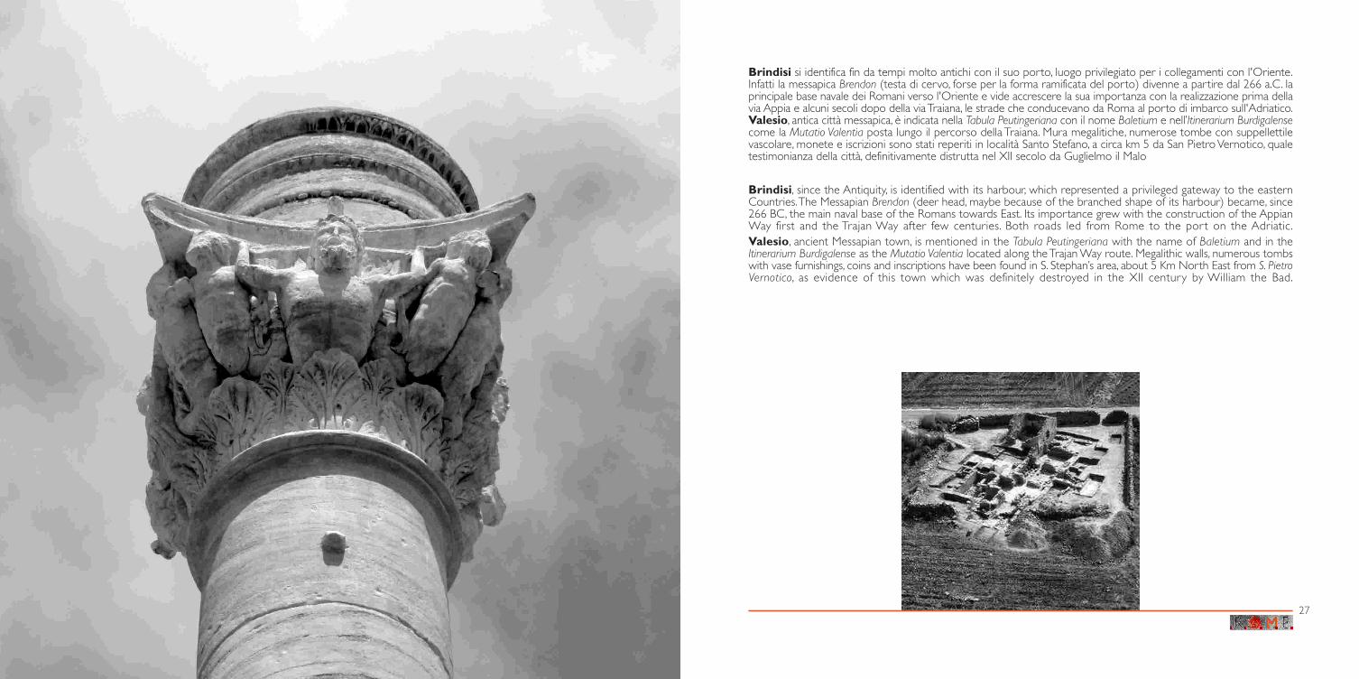
Brindisi si identifica fin da tempi molto antichi con il suo porto, luogo privilegiato per i collegamenti con l'Oriente.Infatti la messapica Brendon (testa di cervo, forse per la forma ramificata del porto) divenne a partire dal 266 a.C. laprincipale base navale dei Romani verso l'Oriente e vide accrescere la sua importanza con la realizzazione prima dellavia Appia e alcuni secoli dopo della via Traiana, le strade che conducevano da Roma al porto di imbarco sull'Adriatico.Valesio, antica città messapica, è indicata nella Tabula Peutingeriana con il nome Baletium e nell’Itinerarium Burdigalensecome la Mutatio Valentia posta lungo il percorso della Traiana. Mura megalitiche, numerose tombe con suppellettilevascolare, monete e iscrizioni sono stati reperiti in località Santo Stefano, a circa km 5 da San Pietro Vernotico, qualetestimonianza della città, definitivamente distrutta nel XII secolo da Guglielmo il Malo
Brindisi, since the Antiquity, is identified with its harbour, which represented a privileged gateway to the easternCountries. The Messapian Brendon (deer head, maybe because of the branched shape of its harbour) became, since266 BC, the main naval base of the Romans towards East. Its importance grew with the construction of the AppianWay first and the Trajan Way after few centuries. Both roads led from Rome to the port on the Adriatic.Valesio, ancient Messapian town, is mentioned in the Tabula Peutingeriana with the name of Baletium and in theItinerarium Burdigalense as the Mutatio Valentia located along the Trajan Way route. Megalithic walls, numerous tombswith vase furnishings, coins and inscriptions have been found in S. Stephan’s area, about 5 Km North East from S. PietroVernotico, as evidence of this town which was definitely destroyed in the XII century by William the Bad.
27

In uno dei più stimolanti dialoghi immaginati da Italo Calvino nel suo splendido “Le città invisibili”, replicando alla domandadi Kublai Kan - Il tuo viaggio si svolge solo nel passato? - Marco Polo spiega - quello che lui cercava era sempre qualcosa davanti asé, e anche se si trattava del passato era un passato che cambiava man mano egli avanzava nel suo viaggio, perché il passato delviaggiatore cambia a seconda dell’itinerario compiuto. -
Credo che questa straordinaria immagine renda bene il significato della conoscenza e della valorizzazione delle straderomane. Il viaggio, ideale e reale, lungo questi tracciati ramificati in tutto l’Impero romano, attraverso città, territori e paesaggi comequel filo che tiene insieme le perle di una collana, consente infatti un percorso di conoscenza del e nel passato. In particolare lavia Traiana, voluta dall’imperatore Traiano agli inizi del II secolo d.C. per collegare Benevento a Brindisi, il più grande porto per icollegamenti con il Mediterraneo orientale, rappresenta un esempio significativo di come una strada sia diventata un importantemezzo di comunicazione per la circolazione di uomini e merci, ma soprattutto di idee.
prof. Giuliano VolpeDirettore del Dipartimento di Scienze Umane, Area di Archeologia dell’Università di Foggia
e Responsabile Scientifico del progetto ROME per la Puglia
In one of the most stimulating dialogues thought by Italo Calvino in his beautiful book “Le città invisibili”, answering KublaiKan’s question - Does your journey occur only in the past? - Marco Polo explains that - what he was looking for was alwayssomething before him, that, set in the past, was a past which was changing little by little while he moved forward in his journey,because the traveller’s past changes according to the accomplished route. -
I believe this extraordinary image well describes the meaning of the Roman road enhancement and knowledge. The realand ideal journey along these branched tracks throughout all the Roman Empire, across cities, territories and landscapes such asthat thread, which holds together pearls in a necklace, allows, as a matter of fact, an itinerary of knowledge of and in the past. Inparticular the Trajan Way, wanted by the emperor Trajan at the beginning of the II century A.D. to connect Benevento and Brindisi,the biggest port for the connections with eastern Mediterranean, represents a significant example of how a road became animportant media for the circulation of men and goods, but mainly of ideas.
prof. Giuliano VolpeHuman Science Department, Archaeological Area University of Foggia,
ROME Project Scientific Responsible for Apulia region
ROME è un progetto al centro del quale la dimensione culturale del dialogo tra i popoli sembra esser l’unico verostrumento per superare il conflitto e le disparità. Terra di mari, terra di transiti, congiunzione tra il passato e il futuro, la Pugliadel Mediterraneo parla di culture diverse e attraverso culture diverse.
La cooperazione, la capacità di immaginare progetti comuni, la volontà di arruolare tutte le forze più vive della societàin un progetto collettivo: è per noi questa l’idea di Mediterraneo.
La storia ci ha insegnato che comunicare è possibile attraverso le vie, la storia e le tradizioni e noi vogliamo recuperareda questo glorioso passato della Puglia, lo stimolo più forte per guardare in avanti e parlare alle giovani generazioni del suddel Mediterraneo di un futuro migliore, di lavoro, di sviluppo, di giustizia e di pace.
prof.ssa Silvia GodelliAssessore al Mediterraneo della Regione Puglia
ROME is a project in which the cultural dimension of the dialogue among people seems to be the only, real tool toovercome the conflict and the disparities. Sea land, transit country, connection between past and future, the Mediterranean Apuliaspeaks about different cultures and through different cultures.
The cooperation, the capability of imagining common projects, the will of recruiting all the most lively society forces in acollective project is this the Mediterranean concept to us.
History told us it is possible to communicate through roads, history and traditions and we want to recover from thisglorious Apulian past the strongest stimulus to look forward and talk to the young generations of the Southern Mediterraneanabout a better future, work, development, justice and peace.
prof. Silvia GodelliMediterranean District Councillor Regione Puglia
Il progetto ROME si inserisce in uno scenario di progressiva convergenza tra il mondo dei beni culturali e le nuovetecnologie informatiche in cui Tecnopolis è attiva protagonista nella formazione di nuove professionalità e nella ricerca di soluzioniinnovative per il mercato pubblico e privato, in campi quali l’apprendimento specializzato ed il turismo culturale.
Operando in raccordo con il sistema universitario, il sistema istituzionale dei beni culturali e le imprese di comunicazionee cultura del territorio, Tecnopolis porta avanti una linea di ricerca avanzata per la costruzione di basi di conoscenza sul complessomondo dei beni culturali, finalizzata alla loro valorizzazione e realizza progetti di Alta formazione post universitaria, in grado disviluppare su background solidamente umanistici, capacità informatiche e telematiche.
dott. Luciano SchiavoniDirettore Generale di Tecnopolis Csata
The ROME project integrates in scenery of progressive convergence between the cultural heritage world and the newcomputer technologies in which Tecnopolis is the active protagonist in the training of new professional people and in theinnovative solution research for the public and private market, in sectors as the specialised learning and the cultural tourism.
Operating in connection with the university, the cultural heritage institutional system and the local cultural andcommunication company, Tecnopolis goes ahead with an advance research for the creation of knowledge bases relative to thecomplex reality of the cultural heritage, that is aimed at their improvement. Moreover Tecnopolis carries out high post-graduateeducation projects meant to develop, on solid humanistic backgrounds, computer and telecommunication skills.
dr Luciano SchiavoniTecnopolis Csata General Manager
IL FUTURO HA UN CUORE ANTICO • FUTURE, ANCIENT HEART
Progetto ROMEROman, ancient greek and amber routes,
innovativeMethodologies and mesaures connecting
Europe

Regione Umbria (Leader Partner) - ITRegione Marche - ITRegione Puglia - IT
Tecnopolis CSATA s.c.r.l. - ITNational Library of Albania - AL
Region of East Macedonia and Thracia - GRMunicipality of Patras - GR
Computer Technology Institut (Telematics center department) - GRAustrian Federal Ministry for Economics and Labour - A
ECO PLUS-Regional Development Agency of lower Austria Gmbh - ANO Kulturwirtschaft GmbH - A
Office of the State Government of Burgenland - AOffice of the State Government of Styria - A
Municipality of Senica - SKCity of Szombathely - HU
Progetto ROMEROman, ancient greek and amber routes,
innovativeMethodologies and mesaures connecting
Europe
PARTNER/PARTNERS
Interreg III B (2000-2006) CADSES - Priorità 3 - Misura 3.1
Il progetto ROMEnasce per valorizzare il patrimonio culturale e ambientale dei paesi dell’area comunitaria CADSES
(Italia, Grecia, Austria, Albania, Slovacchia e Ungheria)attraverso lo sviluppo di un’identità di cui le strade romane e greche e quella dell’ambra in Europa sono la testimonianza.
Su un portale web (www.rome-interreg.net), in cui confluiscono i contributi dei partner, i percorsi delle antiche strade rivivonoe così le nuove tecnologie favoriscono la conoscenza della comune eredità e pongono l’accento sul bisogno attuale di espansione
delle vie commerciali e culturali, in particolare verso l’Europa Orientale e i futuri stati membri.
Troia Panoramica - Miliare via Traiana (Cerignola) / View - Milestone Trajan Way (Cerignola).......... pag. 2Lucera Anfiteatro / Amphitheatre............................................................................................................................................ pag. 3
Herdonia (Ordona) Sito archeologico / Archaeological site ................................................................................................................. pag. 4Bovino Castello / Castle ................................................................................................................................................................. pag. 5
Faragola (Ascoli Satriano) Sito archeologico, resti di villa aristocratica, mosaico pavimentale policromo / Archaeologicalsite, aristocratic villa remains, floor with polychrome mosaic................................................................... pag. 6Stibadium, ricostruzione tridimensionale / Stibadium, 3D reconstruction ...................................... pag. 7
Canosa Via Traiana, ponte sull’Ofanto / Trajan Way, bridge on the Ofanto river............................................ pag. 8Trani Cattedrale romanica di San Nicola pellegrino / St. Nicholas’ Pilgrim Romanic Cathedral ...... pag. 9Ruvo Cattedrale romanica, particolare del portale / Romanic Cathedral, portal detail........................ pag. 10
Castel del Monte Castello di Federico II / Frederick II’s Castle ...................................................................................................... pag. 11Bitonto Cattedrale romanica / Romanic Cathedral......................................................................................................... pag. 12
Rutigliano Chiesa di Sant’Apollinare / St. Apollinaire’s Church....................................................................................... pag. 13Bari Castello svevo / Swabian Castle ............................................................................................................................... pag. 14
Borgo antico, piazza Mercantile / Ancient town, Mercantile Square .................................................... pag. 15Molfetta Vista del porto / Harbour view ............................................................................................................................... pag. 16
Giovinazzo Vista del porto / Harbour view................................................................................................................................. pag. 16Alberobello Scorcio panoramico / Panoramic glimpse........................................................................................................... pag. 16
Ostuni Vista panoramica / Panoramic view........................................................................................................................ pag. 16Locorotondo Strada nel borgo antico / Ancient town street.................................................................................................. pag. 17
Martina Franca Arco di Sant’Antonio / St. Antony’s arch ............................................................................................................ pag. 17Lecce Centro storico, vista di Santa Croce / Ancient town, St. Cross Church............................................. pag. 17
Conversano Castello / Castle ................................................................................................................................................................. pag. 18Polignano a mare Panorama della scogliera / Cliffs view.................................................................................................................... pag. 19
Egnazia Sito archeologico, vista del porto / Archaeological site, harbour view............................................... pag. 20Monopoli Vista aerea del castello / Castle, aerial view. ...................................................................................................... pag. 21
Egnazia Sito archeologico / Archaeological site ................................................................................................................. pag. 22Egnazia Sito archeologico, vista del porto / Archaeological site, harbour view............................................... pag. 23Egnazia Museo archeologico Nazionale / Archaeological National Museum
Testa del dio Attis / Attis god’s head ...................................................................................................................... pag. 24Fasano Masseria, scorcio panoramico / Masseria (farmhouse), panoramic glimpse .................................... pag. 25Brindisi Capitello colonna Traiana /Trajan column capital ............................................................................................ pag. 26
Valesio (S. Pietro Vernotico) Sito archeologico / Archaeological site ................................................................................................................. pag. 27
INDICE DEL PERCORSO GEOGRAFICO/GEOGRAPHICAL ROUTE INDEX
ROME projectaims at exploiting cultural and environmental heritage
in the countries of European Area CADSES (Italy, Greek, Austria, Albania, Slovakia and Hungary)through the development of an identity with Roman, Greek and Amber routes as a proof.
By a web portal (www.rome-interreg.net), where all partners contributions meet, the paths of ancient routes live once again,new technologies support the knowledge of the common heritage and underline current needs to expand commercial
and cultural roads, particularly towards East Europe and the future Member States.
Testi a cura della dott.ssa Anna Introna, traduzioni a cura della società A.Y.N. - All You NeedItalian text edited by dr Anna Introna, translation by A.Y.N. - All You Need