Servizio Monitoraggio dell’Atmosfera (CAMS) › files › copernicus › Deserti-CAMS_1… ·...
65
Servizio Monitoraggio dell’Atmosfera (CAMS) Marco Deserti Responsabile Centro Tematico Regionale Qualità dell'Aria di ARPA Emilia Romagna Seminario ii ll b i d dl Servizi e Collaborative Ground Segment del Programma Copernicus 10 giugno 2015 10 giugno 2015 ROMA Presidenza del Consiglio dei Ministri
Transcript of Servizio Monitoraggio dell’Atmosfera (CAMS) › files › copernicus › Deserti-CAMS_1… ·...

Servizio Monitoraggio dell’Atmosfera (CAMS) Marco Deserti
Responsabile Centro Tematico Regionale Qualità dell'Aria di ARPA Emilia Romagna
Seminarioi i ll b i d d lServizi e Collaborative Ground Segment del
Programma Copernicus10 giugno 201510 giugno 2015
ROMA Presidenza del Consiglio dei Ministri

Contenuti:Contenuti:
t i lità iti ità d l S i i CAMS• potenzialità e criticità del Servizio CAMS,• livello di risposta ai requisiti dell'utenza,• potenziali sinergie
– a) tra i Servizi Copernicusb) i i li d i i– b) con progetti nazionali ed europei in essere
b l l d d l• Possibili linee di indirizzo nazionali per massimizzare il ritorno degli investimenti.
• Questioni aperte per la discussione

IL SERVIZIO CAMS

Richard Engelen.pdf

http://www.copernicus.eu/main/tenders-grants

POTENZIALITÀ E CRITICITÀ DEL SERVIZIO CAMS
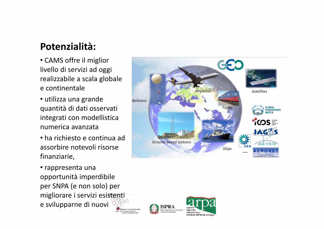
Potenzialità:• CAMS offre il migliorCAMS offre il miglior livello di servizi ad oggi realizzabile a scala globale e continentalee continentale• utilizza una grande quantità di dati osservati integrati con modellistica numerica avanzata• ha richiesto e continua ad assorbire notevoli risorse finanziarie,• rappresenta una• rappresenta una opportunità imperdibile per SNPA (e non solo) per
lmigliorare i servizi esistenti e svilupparne di nuovi

• 6 June 2014, Paris: MACC‐II Second User Workshop, “The Italian users perspective on Atmospheric services by MACC‐II”26 J 2014 R th lt t d t th ti• 26 June 2014, Rome: the results were reported to the meeting about Copernicus Atm. Services at the Italian “Presidenza del consiglio dei ministri”consiglio dei ministri .
• 7 January 2015, Paris: “special workshop on the use of MACC European data as boundary conditions for downstream p ymodeling”
• 3 ‐ 4 March 2015 in Wien, the “ second policy user workshop”,• 11 May 2015, Rome, “user meeting”


Expected objectives of the MACC III user workshop
• Inform the potential community of Italian users about the p yservices that are and will be available by CAMS;
• Encourage and promote the development of downstream service at various levels: institutional, research, commercial;
• Identify/suggest the needs of Italian institutional users;• Define a common working program in order to satisfy the
needs by a collaborative activity between the Italian users i d h d l i C i icommunity and the group developing Copernicus services;
These objectives can lead to the development of new enhanced tools for air quality assessing and forecasting in Italy startingtools for air quality assessing and forecasting in Italy, starting from the current situation characterized by a wide set of operational models already run by Italians users.operational models already run by Italians users.

Requisiti utente (SNPA)Requisiti utente (SNPA)Sh i li f li i h i l d i• Short term air quality forecasts: most Italian regions have implemented an air quality forecast service, for communication purposes, and in some cases also for management of air pollution episodes [Product: AQ Europe forecast]
• Assessment of air quality and population exposure (on daily, seasonal and annual basis). Several applications: compliance with legislation, air quality plans, background concentration fields for the evaluation of specific emitting sources. Thi i h ti l d hi h l ti ( ft 1 kThis requires homogeneous spatial coverage and high resolution (often 1 km or less), and is by far the most pressing issue. This kind of product is presently available only in parts of Italy. [Product: AQ Europe analysis and reanalysis]
l f f l l d d l f• Evaluation of future scenarios. Several applications: design and evaluation of air quality plans, future trends in emissions and AQ, evaluation of new emission policies (e.g. plans for energy production), effects of climate change on air quality, i t t d l ti f i lit d b f t i t [P d t AQ Eintegrated evaluation of air quality and carbon footprint. [Product: AQ Europe, Policy tools: assessment reports, scenarios, S‐R models]

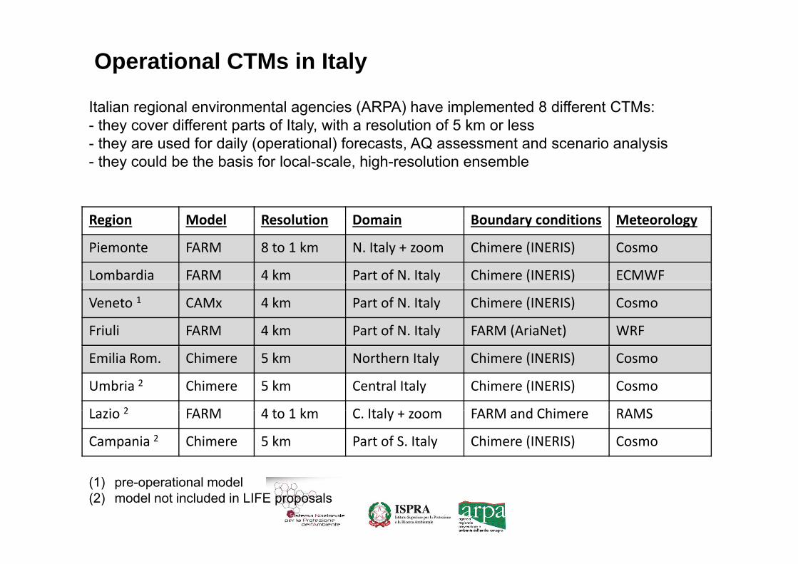
I MODELLI LOCALI (Operational CTMs in Italy)
Italian regional environmental agencies (ARPA) have implemented 8 different CTMs: - they cover different parts of Italy, with a resolution of 5 km or less- they are used for daily (operational) forecasts, AQ assessment and scenario analysis
Region Model Resolution Domain Boundary conditions Meteorology
- they could be the basis for local-scale, high-resolution ensemble
Region Model Resolution Domain Boundary conditions Meteorology
Piemonte FARM 8 to 1 km N. Italy + zoom Chimere (INERIS) Cosmo
Lombardia FARM 4 km Part of N. Italy Chimere (INERIS) ECMWFy ( )
Veneto 1 CAMx 4 km Part of N. Italy Chimere (INERIS) Cosmo
Friuli FARM 4 km Part of N. Italy FARM (AriaNet) WRF
Emilia Rom. Chimere 5 km Northern Italy Chimere (INERIS) Cosmo
Umbria 2 Chimere 5 km Central Italy Chimere (INERIS) Cosmo
L i 2 FARM 4 t 1 k C It l FARM d Chi RAMSLazio 2 FARM 4 to 1 km C. Italy + zoom FARM and Chimere RAMS
Campania 2 Chimere 5 km Part of S. Italy Chimere (INERIS) Cosmo
(1) pre-operational model(2) model not included in LIFE proposals

Air Quality: global modelAir Quality: global model
Richard Engelen.pdf

Air Quality: RAQ modelsAir Quality: RAQ models
Virginie Marecal.pdf


Virginie Marecal.pdf

LIVELLO DI RISPOSTA AI REQUISITI DELL'UTENZA

Forecast productsForecast productsf f h d f• Can satisfy most of the needs of
Italian users, but:– a quantitative verification of ENS
performance in Italy is required; – post elaboration based on
numerical data is requiredq

NRT analysis productsNRT analysis products
• To be improved: – ENS analysis of PM10 and
PM2 5 are not yet produced;PM2.5 are not yet produced; – horizontal resolution of 10 km
is insufficient for most li iapplications.
– Post‐processing is required
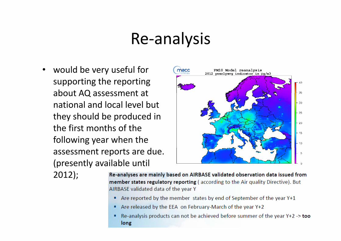
Re analysisRe‐analysis
• would be very useful for supporting the reporting about AQ assessment atabout AQ assessment at national and local level but they should be produced in y pthe first months of the following year when the
dassessment reports are due. (presently available until 2012);2012);

Policy tools:Policy tools:• EU AQ assessment report: can
Ozone daily peak difference (stra‐ref)U Q assess e t epo t caprovide a general frame of reference for regional/local policies no direct use;policies, no direct use;
• Green scenarios: would be useful but numerical data should
fbe delivered for BCON to regional/local models in Italy;
• Emissions inventory: are used by y ysome model suites in Italy, emissions scenarios corresponding to green scenarioscorresponding to green scenarios can be helpful;
• Country Source‐receptor l l i ( d d)calculations (on‐demand): we
need some more details.

Criticità: dati NRT per verifica e assimilazioneCriticità: dati NRT per verifica e assimilazione
Air quality in Italy is affected by a great variety of conditions:
topography, urbanization (large areas p g p y, ( gof diffuse urbanization) and meteorology (regions with Mediterranean, continental, alpine climate); air stagnation in northern ); gItaly, dust transport in southern regions; air pollution hotspots, both diffuse (Po Valley) and localized (large cities and industrial areas, eg. ( g gTaranto).The peculiar characteristics of Italy may require a special verification, and possibly some tuning of CAMS p y gmodels and Ensemble, especially if aerosols are considered

Improvements to MACC products:Improvements to MACC products:l l f d• near real time ENS analysis of PM10 and PM2.5;
• batch download (ftp) of real time MACC products on user‐defined sub‐domains (ensemble and single models, all fields presently disseminated);( g , p y );
• download of time series of real‐time MACC products (web‐accessible database, similar to those already available for global products);
li d i f bl l i id ll i h fi h f• earlier production of ensemble re‐analysis, ideally in the first months of the following year; it is acknowledged that this also depends on the time of availability of air quality observations;
• inclusion of observed daily PM10 concentrations in MACC operational verification (and possibly in data assimilation);
• improved documentation on the actual use of surface observations for• improved documentation on the actual use of surface observations for data assimilation and verification of ensemble members;
• improved documentation on country source‐receptor products.
Possible extensions to MACC products, to be implemented upon appropriate “User License Agreements”:
• real time EPS‐grams relative to a set of Italian cities. EPS‐grams are presently produced for two Italian locations (Rome and S Marino): plots for 20 more locations should beand S.Marino): plots for 20 more locations should be produced in real‐time and made available for batch download;;
• specific verification of MACC products over special areas (Italy, the Mediterranean), with focus on aerosol concentrations;

Products required for air quality management in Italy using a national model
have direct access to:• Near Real Time MACC 3d concentration fields from the global model to be used as boundary conditions for simulations to be performed at European scale and then focused over Italy at high resolution;
• MACC Emission inventory over Europe;ss o e o y o e u ope;• Near real time meteorological fields from IFS as meteorological inputs;meteorological inputs;
• Near Real Time surface concentrations observations over the European domain to evaluate the modelover the European domain to evaluate the model.

Products required for air quality management in Italy that appear to be outside the scope of CAMS services:
• High resolution air quality analysis (maps of surface concentrations of the main pollutants, with a target horizontal resolution of 1 km not requested in real time): this could beresolution of 1 km, not requested in real time): this could be the object of an Italian downstream service, based on MACC products.p
• Boundary conditions for high‐resolutions CTM simulations at national or sub‐national scale (needed for the evaluation of specific, user‐defined emission scenarios): the limited number of chemical species available for both Ensemble and single
d l t l li it th f t MACC d t fmodels strongly limit the use of present MACC products for these applications.

Recommendations:Recommendations:
• The data from Italian in situ monitoring stations: – year 2013 has been delivered to EEA by the national focal point (ISPRA) by the end of April.national focal point (ISPRA) by the end of April.
– It is strongly recommended that the next reanalysis products and verification report includereanalysis products and verification report include the data from Italian stations.

QUESTIONI APERTE PER LA DISCUSSIONE

Conclusioni del workshopConclusioni del workshop
• Il workshop ha definitivamente chiarito che i RAQ models non possono fornire ad oggi BCON ai modelli locali utilizzati dalle ARPA;ARPA;
• Alcuni prodotti, eventualmente migliorati, possono essere usati tal quale o con opportune post elaborazioni;usati tal quale o con opportune post elaborazioni;
• Per consentire il pieno supporto alle attività istituzionali è necessario introdurre un livello di servizi intermedio tra i prodotti CAMS ed i servizi locali prodotti dalle ARPA

Attività conseguenti:Attività conseguenti:
• Avviare la raccolta di dati NRT* (entro le 10 del giorno successivo) dalle stazioni di monitoraggio
• Rendere i dati disponibili a EEA/Copernicus per verifica/assimilazione;
• Costruire un servizio di post elaborazione statistica dei dati Copernicus con dati osservati ;de da ope cus co da osse a ;
• Implementare un servizio di modellistica operativa a scala intermedia tra il modello globale ed i modelliscala intermedia tra il modello globale ed i modelli locali

Postelaborazioni: development of a downstream service: NRT analysisdevelopment of a downstream service: NRT analysis
(an “use case” for Italy and/or Prepair project for Po Valley)
• A geo‐statistical post‐processing of CAMS‐ENS or other CTM fields (data fusion) can be ( )developed
• It would be an extension of services already• It would be an extension of services already available in some Italian regions (E‐R, PI);
• based on background observations and proxy variables (emissions, elevation), with a targetvariables (emissions, elevation), with a target resolution of 1 km;

NRT analysis:a possible downstream service based on geo‐statistical post‐processing of
CAMS‐ENS:
• Italian monitoring networks are wide (*), but it has often been difficult to gather abeen difficult to gather a sufficient amount of homogeneous datag
• for northern Italy, this issue will be addressed in the near future in project Prepair (if funded).
• (*) 616 stations 2012

Il servizio a scala intermedia (nazionale ?)
• Fornisce condizioni iniziali ed al contorno ai modelli regionali/locali anche operativi;F i i i idi i ll d• Fornisce un servizio sussidiario nelle zone dove non sono disponibili modelli locali;
• esecuzione quotidiana per:– Previsioni (entro le 8)– Previsioni (entro le 8)– Analisi NRT + post processing con dati osservati (entro le 10 ?)
• Esecuzione periodica e/o a richiesta:Esecuzione periodica e/o a richiesta:– Rianalisi annuale entro marzo– Scenari tendenziali secondo necessità

Il servizio a scala intermedia (nazionale ?)
• BCON: Copernicus globale • Input meteo: ECMWF + COSMO (I/Med)• Input emissioni: Copernicus‐EU+ISPRA‐I• Validazione e verifica regolare con dati nazionali• Validazione e verifica regolare con dati nazionali.• Possibili domini di lavoro e risoluzione orizzontale:
Gl b l i 80 k– Globale copernicus, 80 km– Continentale: 30‐50 km + nazionale: 10‐5 km o continentale 10 kmcontinentale 10 km
– Regionale/Locale (ARPA): 5 – 1 Km[C ti t l RAQ i t 10 25 k ] ? ili– [Continentale RAQ copernicus: tra 10 e 25 km] ? utilizzato come benchmark
Il servizio a scala intermedia (nazionale ?)
• Codice/i di calcolo:– Open source (garantire il riuso nella PA, codice p (g ,sorgente disponibile per sviluppo)
– Community model: comunità di sviluppatori cheCommunity model: comunità di sviluppatori che ne garantisca la continuità;Input/output compatibile/interfacciabile con– Input/output compatibile/interfacciabile con standard copernicus e singoli modelli regionali;
• Il servizio può essere basato su più codici tra loro ridondanti e/o intercambiabili

Il servizio a scala intermedia (nazionale ?)
• Deve essere individuata con chiarezza una struttura che garantisca l’operatività del g pservizio;
• L’esecutore del servizio deve soddisfare• Lesecutore del servizio deve soddisfare requisiti ben definiti;
• La forma di attribuzione può essere un bando pubblico aperto a soggetti privati o agenziepubblico aperto a soggetti privati o agenzie eventualmente consorziati tra loro.

SINERGIE CON PROGETTI
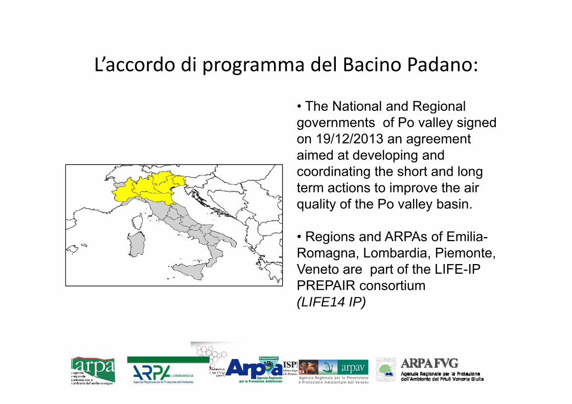
L’accordo di programma del Bacino Padano:Laccordo di programma del Bacino Padano:
• The National and RegionalThe National and Regional governments of Po valley signed on 19/12/2013 an agreement aimed at developing andaimed at developing and coordinating the short and long term actions to improve the air quality of the Po valley basinquality of the Po valley basin.
• Regions and ARPAs of Emilia-R L b di PiRomagna, Lombardia, Piemonte, Veneto are part of the LIFE-IP PREPAIR consortium (LIFE14 IP)

Ongoing projects by the Po valley regions:Ongoing projects by the Po valley regions:
• LIFE‐IP PREPAIR: Implementing the AQ action plans and building the technical tools for monitoring the AQ action plans;plans;
• Some core actions of the project are aimed at:– regular runs of an ensemble of 5 CTMs on the northern Italy domain;regular runs of an ensemble of 5 CTMs on the northern Italy domain;– realizing a permanent infrastructure for sharing air quality monitoring
(NRT) and emissions data and CTMs outputs;– model outputs will be post‐processed by monitoring data for bias
correction and enhanced spatial resolution;– model outputs will be verified and tuned by data from special stationsmodel outputs will be verified and tuned by data from special stations
(supersites) and IO campaigns.


The ensemble of CTMs models on Po valley:
• Is based on models already implemented by each partner [MINNI, NINFA‐ER, FARM‐PI, FARM‐LO, pFARM‐FvG, CAMX‐VE]
– The application domains and emissions input data pp pwill be unified;
– The numerical code model set‐up andThe numerical code, model set up and meteorological driver will remain different;Boundary conditions are different but: “ i l ff t– Boundary conditions are different but: “a special effort will be addressed to interfacing the new operational services to the atmospheric services of the European programme Copernicus”
Some details about the Po valley modelsMODELING TOOLS FOR AQ
y
MANAGEMENT IN ITALY
Operational CTMs in Italy
Italian regional environmental agencies (ARPA) have implemented 8 different CTMs: - they cover different parts of Italy, with a resolution of 5 km or less- they are used for daily (operational) forecasts, AQ assessment and scenario analysis
Region Model Resolution Domain Boundary conditions Meteorology
- they could be the basis for local-scale, high-resolution ensemble
Region Model Resolution Domain Boundary conditions Meteorology
Piemonte FARM 8 to 1 km N. Italy + zoom Chimere (INERIS) Cosmo
Lombardia FARM 4 km Part of N. Italy Chimere (INERIS) ECMWFy ( )
Veneto 1 CAMx 4 km Part of N. Italy Chimere (INERIS) Cosmo
Friuli FARM 4 km Part of N. Italy FARM (AriaNet) WRF
Emilia Rom. Chimere 5 km Northern Italy Chimere (INERIS) Cosmo
Umbria 2 Chimere 5 km Central Italy Chimere (INERIS) Cosmo
L i 2 FARM 4 t 1 k C It l FARM d Chi RAMSLazio 2 FARM 4 to 1 km C. Italy + zoom FARM and Chimere RAMS
Campania 2 Chimere 5 km Part of S. Italy Chimere (INERIS) Cosmo
(1) pre-operational model(2) model not included in LIFE proposals

esempi
MODELLI REGIONALI PO VALLEYesempi

The operational models suite NINFApNorthern Italian Network to Forecast photochemical and Aerosol pollution
NINFA‐E (daily forecast & analysis, ( y y ,scenarios):•5 km horizontal resolution, 8 vertical levels up to 500 hPahtt // it/ i /? lit i / i i i i dhttp://www.arpa.emr.it/sim/?qualita_aria/previsioni_aria_nordhttp://www.arpa.emr.it/aria/
NINFA‐national :run on demand scenarios•run on demand, scenarios
•Italy:89*105, 10 km•North:138*92, 5 km•South: 110*100, 5 km
PESCO (geo statistical post processing):• daily and annual compliance evaluation NRT data from E R AQ stations 1km• NRT data from E‐R AQ stations, 1km
•CTM: Chimere•Boundary conditions: Prev’air (0.5°~ 50 km)
•Meteorological input: COSMO‐I7 (7 km)•Emissions: adapted from INEMAR ER + IspraItaly + MACCT‐TNO

The PESCO‐NINFA postprocessing for unbiasing and downscaling
It produces surface concentrations fields of PM10, PM2.5, O3, NO2 over a regular grid covering the Emilia-Romagna region with a resolution of 1 km
Evaluation of the compliance with EU legislation (year 2010)

ARPA Lombardia air quality modeling systemB d th di i l E l i d l FARM (Fl ibl Ai Q lit R i l M d lBased on three-dimensional Eulerian model FARM (Flexible Air Quality Regional Model,https://hpc-forge.cineca.it/files/Farm/public/)
Domain: covering the whole Lombardy Region (horizontal resolution of 4 km)Domain: covering the whole Lombardy Region (horizontal resolution of 4 km)
Meteo driver: ECMWF, mass consistent model minerve
B d diti CHIMERE ti t l fi ld id d b P Ai iBoundary conditions CHIMERE continental fields provided by PrevAir service
Emission inventories: Detailed regional emission inventories, ISPRA national emissioninventory, EMEP inventoryinventory, EMEP inventory
Support to evaluation Services Results from
scenarios AQ regional plan Support to evaluation
AQ planregional plan
Yearly AQ modeling ss ss t AQMA
Services reports available on web site from AQMA 2009 assessment AQMA AQMA 2009 year
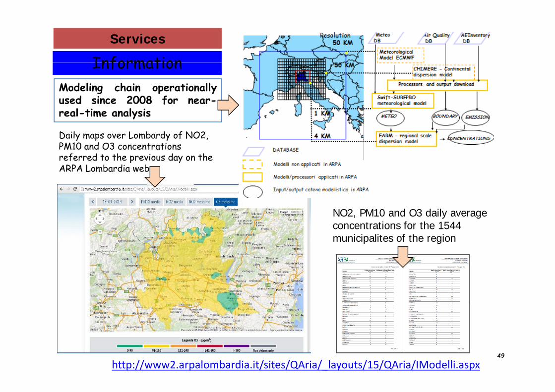
InformationServices
InformationModeling chain operationallyused since 2008 for near-
Daily maps over Lombardy of NO2, PM10 and O3 concentrations
real-time analysis
referred to the previous day on the ARPA Lombardia web
NO2, PM10 and O3 daily average concentrations for the 1544 municipalites of the regionmunicipalites of the region
4949
http://www2.arpalombardia.it/sites/QAria/_layouts/15/QAria/IModelli.aspx

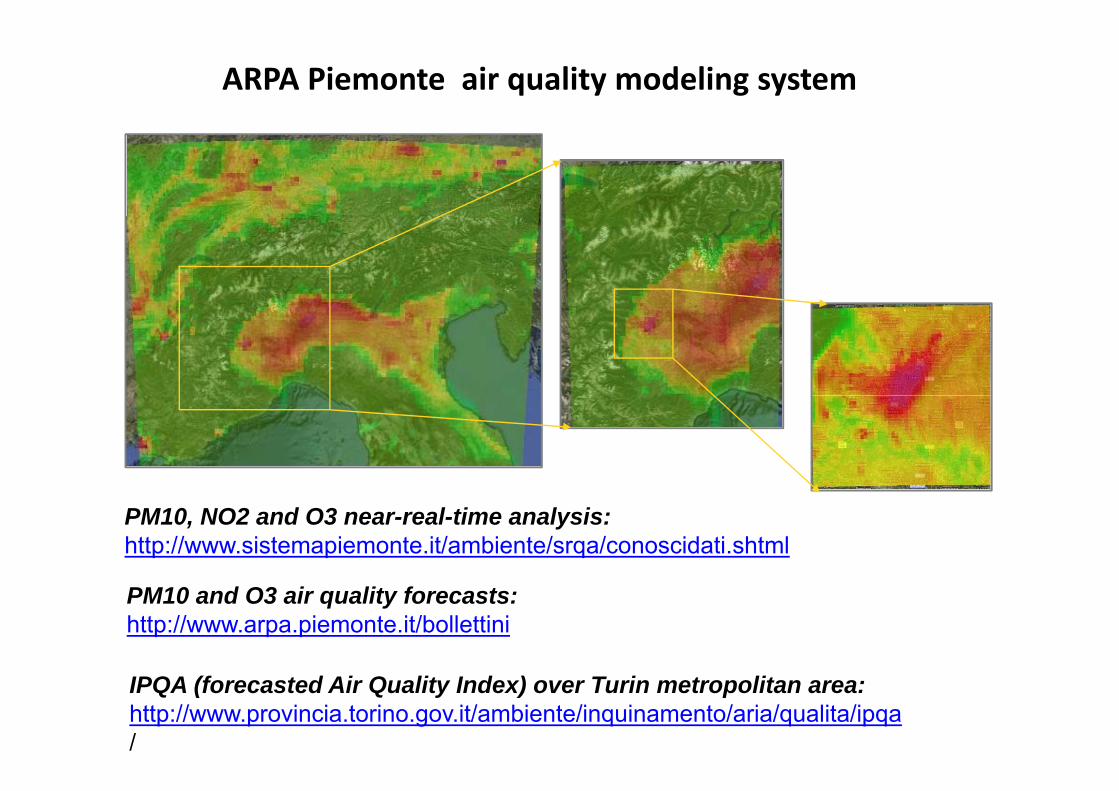
ARPA Piemonte air quality modeling system
( QBased on three-dimensional Eulerian model FARM (Flexible Air QualityRegional Model, https://hpc-forge.cineca.it/files/Farm/public/ )
Operationally used for:Operationally used for:● Daily air quality forecasts: forecast time 72 hours (3 days from today 01:00 a.m);● Daily near-real-time analysis;● Yearly assessment of air quality,
Domain: three nested domains:g1 covering Po valley basin and the Alps (horizontal resolution of 8 km);
y q y,● Evaluation of future scenarios.
● g1 covering Po valley basin and the Alps (horizontal resolution of 8 km);● g2 covering the whole Piemonte Region (horizontal resolution of 4 km);● 3 g3 domains, with 1 km horizontal resolution (only in forecast mode)
M t d iMeteo driver:COSMO model (aq forecast); ECMWF, mass consistentmodel minerve, WRF (aq assessment and nrt);
( f 1 )Boundary conditions (only for the g1 domain):CHIMERE continental fields (analysis and forecast)provided by PrevAir serviceE i i i t iEmission inventories:Detailed regional emission inventories, ISPRA nationalemission inventory, EMEP inventory
ARPA Piemonte air quality modeling system
PM10, NO2 and O3 near-real-time analysis:http://www.sistemapiemonte.it/ambiente/srqa/conoscidati.shtml
PM10 and O3 air quality forecasts:http://www.arpa.piemonte.it/bollettini
IPQA (forecasted Air Quality Index) over Turin metropolitan area:http://www.provincia.torino.gov.it/ambiente/inquinamento/aria/qualita/ipqa/
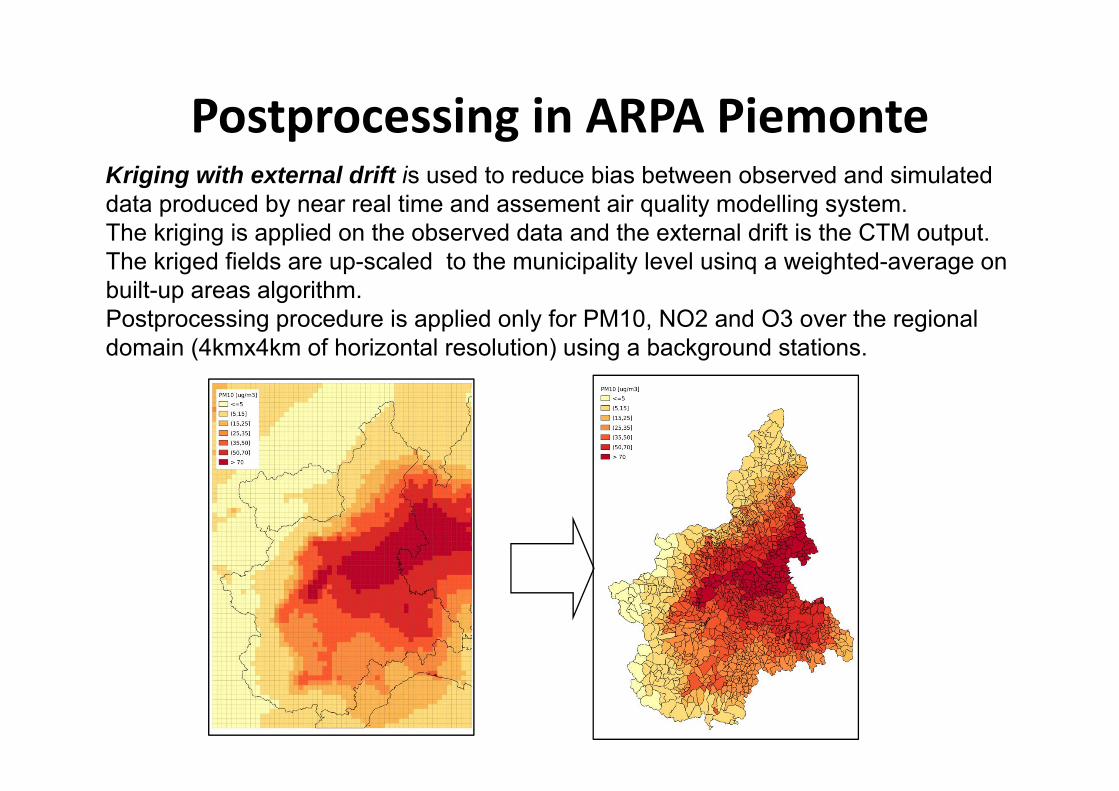
Postprocessing in ARPA PiemonteKriging with external drift is used to reduce bias between observed and simulated data produced by near real time and assement air quality modelling system.
Postprocessing in ARPA Piemontep y q y g y
The kriging is applied on the observed data and the external drift is the CTM output.The kriged fields are up-scaled to the municipality level usinq a weighted-average on built-up areas algorithm.Postprocessing procedure is applied only for PM10, NO2 and O3 over the regional domain (4kmx4km of horizontal resolution) using a background stations.

ARPA FVG air quality modelling system (off‐line weather/air quality) Air quality forecast and analysisWeather forecast and analysis qua ty o ecast a d a a ys sFARM model 4 km x 4 kmWeather simulations
•WRFAir quality boundary conditions
Weather forecast and analysisWRF modelBoundary condition NCEP/NOAA (GFS)3 nested domains Air quality boundary conditions
•QualeAria (ARIANET)Sources
•INEMAR regional inventory
Europe, Italy, FVG Region (2 km x 2 km)
5 daysforecastforecast
+120h
Operational applicationsForecast and scenarios in support to:
Municipality mitigation actions activation (PACs)Regional government mitigation plansRegional operational air quality assessmentsHealthcare applications and warnings
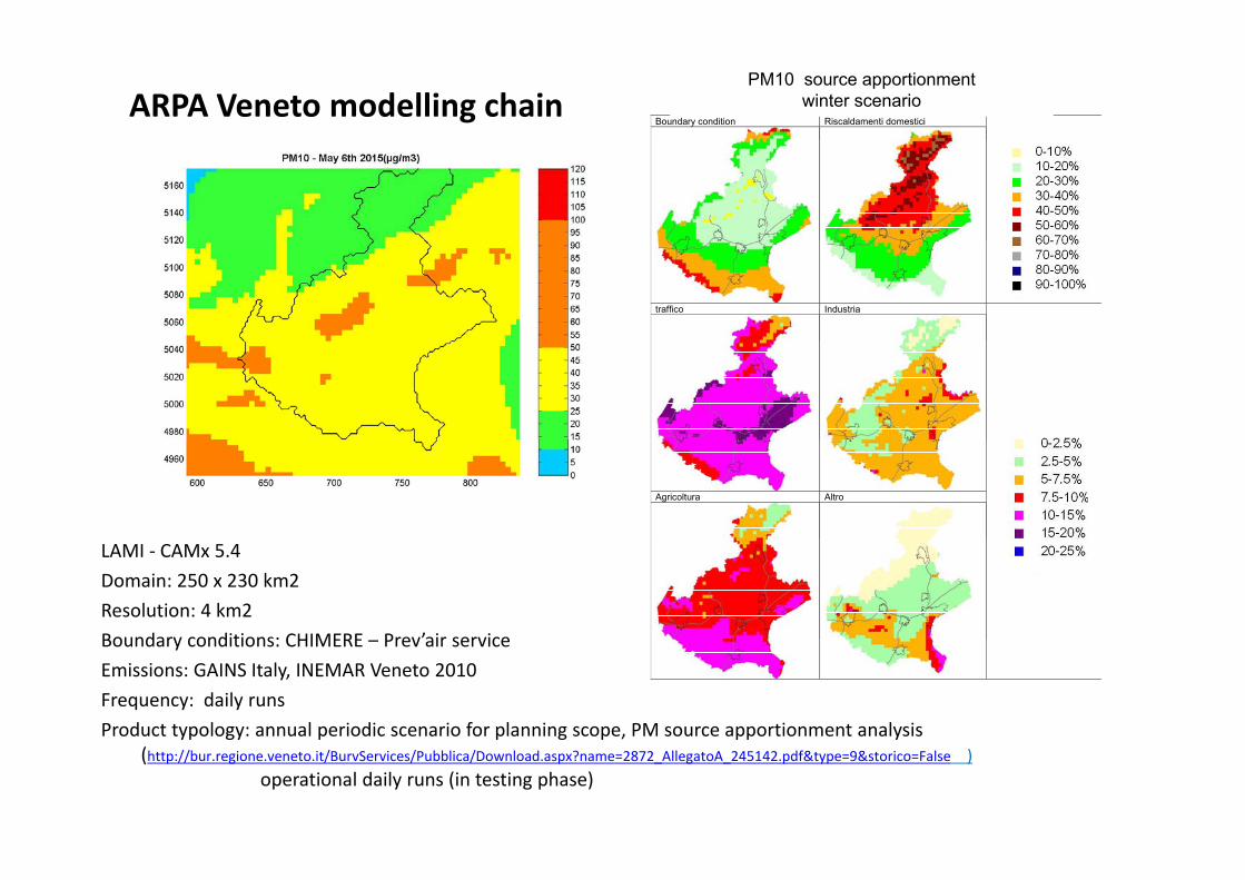
ARPA Veneto modelling chainBoundary condition Riscaldamenti domestici
PM10 source apportionment winter scenario
traffico Industria
Agricoltura Altro
LAMI ‐ CAMx 5.4Domain: 250 x 230 km2Resolution: 4 km2Boundary conditions: CHIMERE Prev’air service
Boundary conditions: CHIMERE – Prev air serviceEmissions: GAINS Italy, INEMAR Veneto 2010Frequency: daily runs Product typology: annual periodic scenario for planning scope, PM source apportionment analysis
yp gy p p g p pp y(http://bur.regione.veneto.it/BurvServices/Pubblica/Download.aspx?name=2872_AllegatoA_245142.pdf&type=9&storico=False )
operational daily runs (in testing phase)

Umbria

MODELLI ITALIANI A SCALANAZIONALE

MINNI – AMS NATIONAL DOMAINS


NINFA‐I

Emissions data

The national Meteorological model: COSMO/LAMA
Il modello COSMOE’ il modello di riferimento italiano All’interno di ARPA-SIMC a livello
ti d d lt loperativo produce due volte al giorno previsioni meteorologiche per tutta Italia, con una risoluzione orizzontale di 7 km (COSMO-I7) ( )
Il dataset LAMAIl dataset LAMA sfrutta il ciclo di
i il i di COSMO I Ilassimilazione di COSMO- I. Il modello compie una serie di simulazioni di 12 ore, ciascuna delle quali usa come condizione qiniziale i campi in quota prodotti dalla corsa precedente, i campi superficiali del modello. D rante la sim la ione il modelloDurante la simulazione, il modello utilizza una tecnica di nudging per assimilare in modo continuo le osservazioni disponibili.p
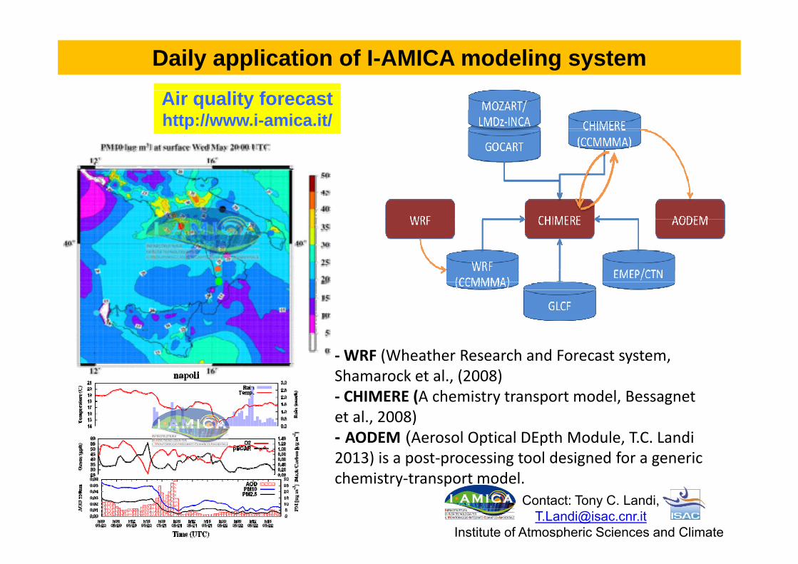
Daily application of I-AMICA modeling systemAir quality forecasthttp://www.i-amica.it/
‐WRF (Wheather Research and Forecast system, Shamarock et al., (2008)‐ CHIMERE (A chemistry transport model, Bessagnet et al., 2008)- AODEM (Aerosol Optical DEpth Module, T.C. Landi 2013) is a post‐processing tool designed for a generic h i t t t d l
Contact: Tony C. Landi, [email protected]
Institute of Atmospheric Sciences and Climate
chemistry‐transport model.

Nesting for I-AMICA modeling systemEUR54
Horizontal res. 54 km
ITA18 Horizontal res. 18 km
IAM6 Horizontal res. 6 km

Daily application of I-AMICA modeling system
AODEM
MODIS CHIMERE
Satellite and Aerosol modelinghttp://www.isac.cnr.it/cimone/SMA
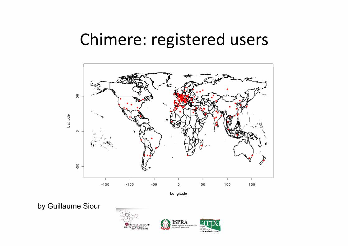
Chimere: registered usersChimere: registered users
by Guillaume Siourby Guillaume Siour