Quaboag (North) Pond !(9 32 21 !( 9 67 31
2
LAKE ROAD WEST STURBRIDGE ROAD SHORE ROAD STONE ROAD RICE ROAD PINE LANE RED GABLE ROAD CANAL ROAD OLD LAKE ROAD TERRY LANE OAKWOOD DRIVE SHORE ROAD HERBERT ROAD Quaboag (North) Pond 558 Acres Brookfield, East Brookfield Chicopee River Watershed PALMER WARREN SPENCER BRIMFIELD MONSON BROOKFIELD CHARLTON WEST BROOKFIELD STURBRIDGE NORTH BROOKFIELD EAST BROOKFIELD ! ( 9 ! ( 31 ! ( 67 § ¨ ¦ 90 ^ ^ Coordinates: 72°03'45 W 42°12'12 N USGS Quad: EAST BROOKFIELD ! y 5 10 ³ # # GATE " S # # # # 5 10 ! ( 9 # # r 15 Quacumquasit WMA # # # Qu a bo a g Ri v e r ¬ « 148 y Boat Ramp- Concrete Wetland Building Structures Road Stream- Flow Direction # Deepest Point Dam Major Road Island/Sand Bar Interstate r 15 Not for navigational purposes Depth Contours- 5 Feet Map updated May, 2016 0 ½ Miles ¼ Depth contours based on 14,376 sonar soundings Quacumquasit WMA
Transcript of Quaboag (North) Pond !(9 32 21 !( 9 67 31
LAKE
ROA
D
WEST
STUR
BRID
GE R
OAD
SHORE ROAD
STONE ROAD
RICE ROAD
PINE LANE
RED GABLE ROAD
CANAL ROADOLD LAKE ROAD
TERRY LANE
OAKW
OOD
DRIV
E
SHORE ROADHERBERT ROAD
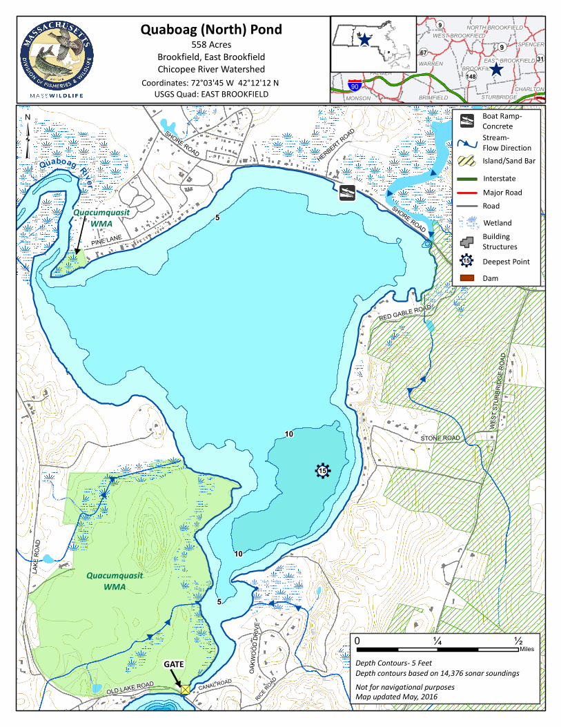
Quaboag (North) Pond558 Acres
Brookfield, East BrookfieldChicopee River Watershed PALMER
WARREN
WARE
SPENCER
BRIMFIELDMONSON
BROOKFIELD
BELCHERTOWN
CHARLTON
WEST BROOKFIELD
STURBRIDGE
NORTH BROOKFIELD
EAST BROOKFIELDLUDLOW
!(9
!(31!(21
!(32
!(67
§̈¦90^
^
Coordinates: 72°03'45 W 42°12'12 N USGS Quad: EAST BROOKFIELD
!y
5
10
³#
#
GATE
"S
#
#
#
#
5
10
!(9
#
#
r15
QuacumquasitWMA
#
#
#Quaboag River
¬«148
yBoat Ramp-Concrete
WetlandBuildingStructures
Road
Stream- Flow Direction#
Deepest PointDam
Major Road
Island/Sand BarInterstate
r15
Not for navigational purposes
Depth Contours- 5 Feet
Map updated May, 2016
0 ½Miles
¼
Depth contours based on 14,376 sonar soundings
QuacumquasitWMA

Quaboag Pond, Brookfield / E. Brookfield
General Information Quaboag Pond is a 558 acre Great Pond located approximately 2 miles southeast of Brookfield center on the Brookfield-East Brookfield town line. Quaboag Pond has an average depth of 6 feet, a maximum of 16 feet, and aquatic vegetation is relatively common within areas less than 10ft deep. The majority of shoreline development occurs on the northern and eastern shores. The Quacumquasit Wildlife Management Area is located on the southwestern shore and is undeveloped. Quaboag Pond is fed by the East Brookfield River and the Quaboag River, the latter of which is navigable to boaters for some distance through the Quaboag Wildlife Management Area up to the Davis Road crossing (not shown on map). Quaboag Pond is a popular destination for recreational boaters, swimmers, and paddlers during the summer months. Recreational Access The town of Brookfield manages a large concrete boat ramp (72°3'46.230"W 42°12'13.253"N) and adjacent parking area suitable for 30 trailers on the north shore of the pond off Shore Road. Shoreline access is available along Shore Road on the north end, and from the Quacumquasit Wildlife Management Area on the southwestern shore. Please contact the offices of the town of Brookfield for additional information, fee structure, and/or restrictions pertaining to public access of Quaboag Pond. Fish Populations The following fish species were found during MassWildlife surveys: Largemouth Bass, Northern Pike, Chain Pickerel, Yellow Perch, White Perch, Black Crappie, Bluegill, Pumpkinseed, Redbreast Sunfish, Brown Bullhead, Yellow Bullhead, landlocked Alewife, Golden Shiner, and White Sucker. Quaboag Pond is also stocked occasionally with Northern Pike when available. Please check the MassWildlife Northern Pike and Tiger Muskellunge stocking page online for stocking dates. Fishing Quaboag Pond is known throughout Massachusetts for its trophy Northern Pike, which occasionally exceed 20 pounds in weight. The majority of these fish are caught through the ice in winter along with good numbers of Black Crappie, Chain Pickerel, and Largemouth Bass, a few of which have been reported to exceed 7 pounds. Fishing the shores and weed beds of the Quaboag River for bass and pickerel is popular during summer as is fishing for Bullhead in the main body of the pond. Quaboag Pond has produced Largemouth Bass, Northern Pike, Chain Pickerel, Yellow Perch, White Perch, crappie, sunfish, and bullhead that meet minimum sizes for recognition by the Sportfishing Awards Program.
Useful Links: Get your Fishing License
Freshwater Fishing
Trout Stocking Information Freshwater Sportfishing Awards Program Learn more: Mass.gov/MassWildlife Connect with us: Facebook.com/MassWildlife Your local MassWildlife office: 211 Temple Street West Boylston, MA 01583 (508) 835-3607
STOP AQUATIC HITCHIKERS! Prevent the transport of nuisance species. Clean all recreational equipment. ProtectYourWaters.net Updated: 2016