Milchsteig Wilde Kreuzspitze 4 Sentiero del Latte Picco della … · novia Jochtal Easy/medium hike...
1
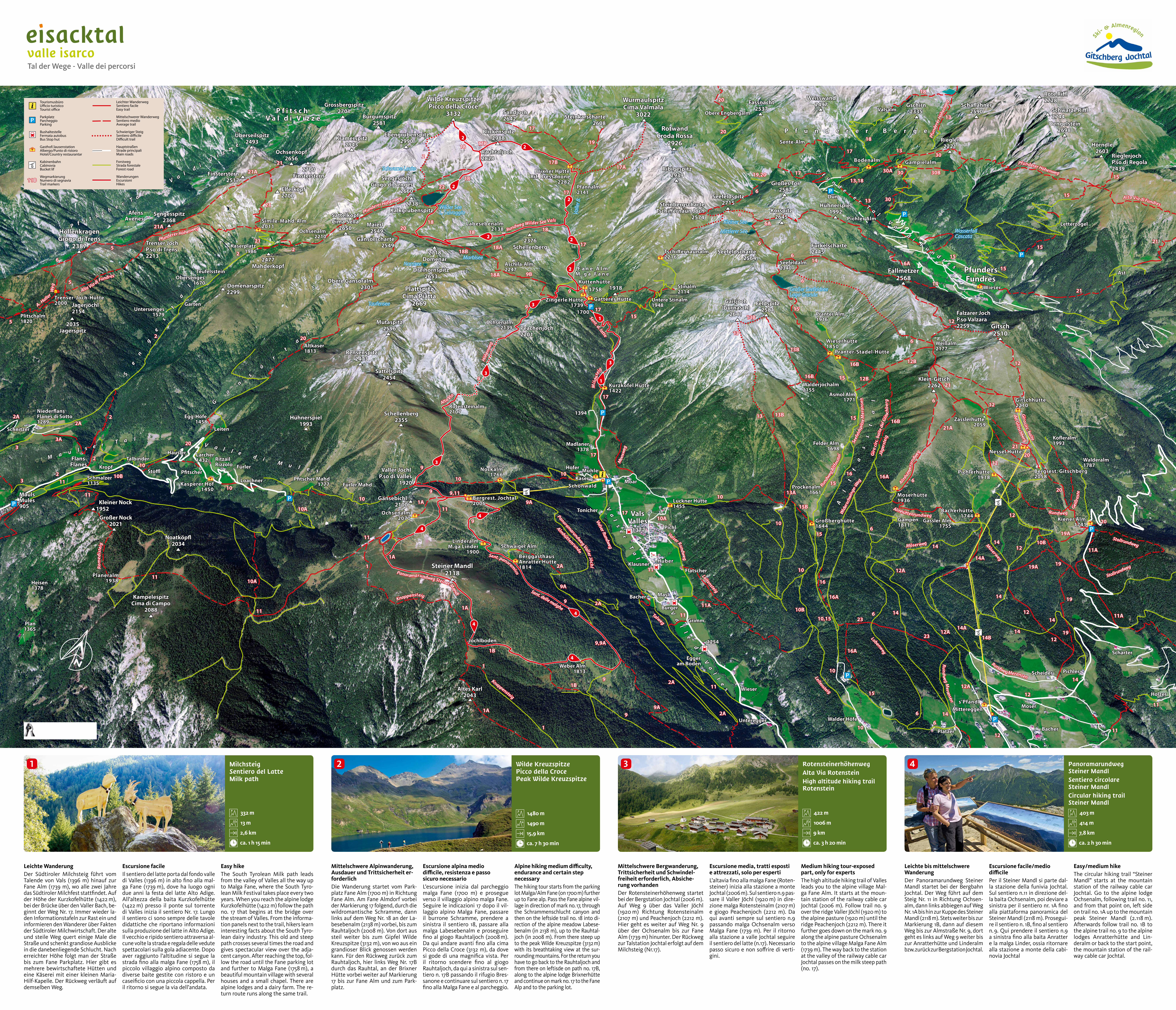
Panoramarundweg Steiner Mandl Sentiero circolare Steiner Mandl Circular hiking trail Steiner Mandl c 403 m d 414 m e 7,8 km b ca. 2 h 30 min Rotensteinerhöhenweg Alta Via Rotenstein High altitude hiking trail Rotenstein c 422 m d 1006 m e 9 km b ca. 3 h 20 min Wilde Kreuzspitze Picco della Croce Peak Wilde Kreuzspitze c 1480 m d 1490 m e 15,9 km b ca. 7 h 30 min Milchsteig Sentiero del Latte Milk path c 332 m d 13 m e 2,6 km b ca. 1 h 15 min Leichte bis mittelschwere Wanderung Der Panoramarundweg Steiner Mandl startet bei der Bergbahn Jochtal. Der Weg führt auf dem Steig Nr. 11 in Richtung Ochsen- alm, dann links abbiegen auf Weg Nr. 1A bis hin zur Kuppe des Steiner Mandl (2118 m). Stets weiter bis zur Markierung 1B, dann auf diesem Weg bis zur Almstraße Nr. 9, dort geht es links auf Weg 9 weiter bis zur Anratterhütte und Linderalm bzw. zurück zur Bergstation Jochtal. Escursione facile/medio difficile Per il Steiner Mandl si parte dal- la stazione della funivia Jochtal. Sul sentiero n.11 in direzione del- la baita Ochsenalm, poi deviare a sinistra per il sentiero nr. 1A fino alla piattaforma panoramica del Steiner Mandl (2118 m). Prosegui- re il sentiero n. 1B, fino al sentiero n. 9. Qui prendere il sentiero n.9 a sinistra fino alla baita Anratter e la malga Linder, ossia ritornare alla stazione a monte della cabi- novia Jochtal Easy/medium hike The circular hiking trail “Steiner Mandl” starts at the mountain station of the railway cable car Jochtal. Go to the alpine lodge Ochsenalm, following trail no. 11, and from that point on, left side on trail no. 1A up to the mountain peak Steiner Mandl (2.118 m). Afterwards follow trail no. 1B to the alpine trail no. 9 to the alpine lodges Anratterhütte and Lin- deralm or back to the start point, the mountain station of the rail- way cable car Jochtal. Mittelschwere Bergwanderung, Trittsicherheit und Schwindel- freiheit erforderlich, Absiche- rung vorhanden Der Rotensteinerhöhenweg startet bei der Bergstation Jochtal (2006 m). Auf Weg 9 über das Valler Jöchl (1920 m) Richtung Rotensteinalm (2107 m) und Peachenjoch (2212 m). Hier geht es weiter auf Weg Nr. 9 über der Ochsenalm bis zur Fane Alm (1739 m) hinunter. Der Rückweg zur Talstation Jochtal erfolgt auf dem Milchsteig (Nr.17). Escursione media, tratti esposti e attrezzati, solo per esperti L’altavia fino alla malga Fane (Roten- steiner) inizia alla stazione a monte Jochtal (2006 m). Sul sentiero n.9 pas- sare il Valler Jöchl (1920 m) in dire- zione malga Rotensteinalm (2107 m) e giogo Peachenjoch (2212 m). Da qui avanti sempre sul sentiero n.9 passando malga Ochsenalm verso Malga Fane (1739 m). Per il ritorno alla stazione a valle Jochtal seguire il sentiero del latte (n.17). Necessario passo sicuro e non soffrire di verti- gini. Medium hiking tour-exposed part, only for experts The high altitude hiking trail of Valles leads you to the alpine village Mal- ga Fane Alm. It starts at the moun- tain station of the railway cable car Jochtal (2006 m). Follow trail no. 9 over the ridge Valler Jöchl (1920 m) to the alpine pasture (1920 m) until the ridge Peachenjoch (2212 m). There it further goes down on the mark no. 9 along the alpine pasture Ochsenalm to the alpine village Malga Fane Alm (1739 m). The way back to the station at the valley of the railway cable car Jochtal passes on the milk steep path (no. 17). Mittelschwere Alpinwanderung, Ausdauer und Trittsicherheit er- forderlich Die Wanderung startet vom Park- platz Fane Alm (1700 m) in Richtung Fane Alm. Am Fane Almdorf vorbei der Markierung 17 folgend, durch die wildromantische Schramme, dann links auf dem Weg Nr. 18 an der La- besebenalm (2138 m) vorbei, bis zum Rauhtaljoch (2008 m). Von dort aus steil weiter bis zum Gipfel Wilde Kreuzspitze (3132 m), von wo aus ein grandioser Blick genossen werden kann. Für den Rückweg zurück zum Rauhtaljoch, hier links Weg Nr. 17B durch das Rauhtal, an der Brixner Hütte vorbei weiter auf Markierung 17 bis zur Fane Alm und zum Park- platz. Escursione alpina medio difficile, resistenza e passo sicuro necessario L’escursione inizia dal parcheggio malga Fane (1700 m) e prosegue verso il villaggio alpino malga Fane. Seguire le indicazioni 17 dopo il vil- laggio alpino Malga Fane, passare il burrone Schramme, prendere a sinistra il sentiero 18, passare alla malga Labesebenalm e proseguire fino al giogo Rauhtaljoch (2008 m). Da qui andare avanti fino alla cima Picco della Croce (3132 m), da dove si gode di una magnifica vista. Per il ritorno scendere fino al giogo Rauhtaljoch, da qui a sinistra sul sen- tiero n. 17B passando il rifugio Bres- sanone e continuare sul sentiero n. 17 fino alla Malga Fane e al parcheggio. Alpine hiking medium difficulty, endurance and certain step necessary The hiking tour starts from the parking lot Malga/Alm Fane (on 1700 m) further up to Fane alp. Pass the Fane alpine vil- lage in direction of mark no. 17, through the Schrammenschlucht canyon and then on the leftside trail no. 18 into di- rection of the alpine meadow Labese- benalm (in 2138 m), up to the Rauhtal- joch (in 2008 m). From there steep up to the peak Wilde Kreuzspitze (3132 m) with its breathtaking view at the sur- rounding mountains. For the return you have to go back to the Rauhtaljoch and from there on leftisde on path no. 17B, along to the alpine lodge Brixnerhütte and continue on mark no. 17 to the Fane Alp and to the parking lot. Leichte Wanderung Der Südtiroler Milchsteig führt vom Talende von Vals (1396 m) hinauf zur Fane Alm (1739 m), wo alle zwei Jahre das Südtiroler Milchfest stattfindet. Auf der Höhe der Kurzkofelhütte (1422 m), bei der Brücke über den Valler Bach, be- ginnt der Weg Nr. 17. Immer wieder la- den Informationstafeln zur Rast ein und informieren den Wanderer über Fakten der Südtiroler Milchwirtschaft. Der alte und steile Weg quert einige Male die Straße und schenkt grandiose Ausblicke in die danebenliegende Schlucht. Nach erreichter Höhe folgt man der Straße bis zum Fane Parkplatz. Hier gibt es mehrere bewirtschaftete Hütten und eine Käserei mit einer kleinen Maria- Hilf-Kapelle. Der Rückweg verläuft auf demselben Weg. Escursione facile Il sentiero del latte porta dal fondo valle di Valles (1396 m) in alto fino alla mal- ga Fane (1739 m), dove ha luogo ogni due anni la festa del latte Alto Adige. All’altezza della baita Kurzkofelhütte (1422 m) presso il ponte sul torrente di Valles inizia il sentiero Nr. 17. Lungo il sentiero ci sono sempre delle tavole didattiche che riportano informazioni sulla produzione del latte in Alto Adige. Il vecchio e ripido sentiero attraversa al- cune volte la strada e regala delle vedute spettacolari sulla gola adiacente. Dopo aver raggiunto l’altitudine si segue la strada fino alla malga Fane (1758 m), il piccolo villaggio alpino composto da diverse baite gestite con ristoro e un caseificio con una piccola cappella. Per il ritorno si segue la via dell’andata. Easy hike The South Tyrolean Milk path leads from the valley of Valles all the way up to Malga Fane, where the South Tyro- lean Milk Festival takes place every two years. When you reach the alpine lodge Kurzkofelhütte (1422 m) follow the path no. 17 that begins at the bridge over the stream of Valles. From the informa- tion panels next to the trail, hikers learn interesting facts about the South Tyro- lean dairy industry. This old and steep path crosses several times the road and gives spectacular view over the adja- cent canyon. After reaching the top, fol- low the road until the Fane parking lot and further to Malga Fane (1758 m), a beautiful mountain village with several houses and a small chapel. There are alpine lodges and a dairy farm. The re- turn route runs along the same trail. 4 3 2 1
Transcript of Milchsteig Wilde Kreuzspitze 4 Sentiero del Latte Picco della … · novia Jochtal Easy/medium hike...
Panoramarundweg Steiner MandlSentiero circolare Steiner MandlCircular hiking trail Steiner Mandl
c 403 m
d 414 m
e 7,8 km
b ca. 2 h 30 min
RotensteinerhöhenwegAlta Via RotensteinHigh altitude hiking trail Rotenstein
c 422 m
d 1006 m
e 9 km
b ca. 3 h 20 min
Wilde KreuzspitzePicco della CrocePeak Wilde Kreuzspitze
c 1480 m
d 1490 m
e 15,9 km
b ca. 7 h 30 min
MilchsteigSentiero del LatteMilk path
c 332 m
d 13 m
e 2,6 km
b ca. 1 h 15 min
Leichte bis mittelschwere WanderungDer Panoramarundweg Steiner Mandl startet bei der Bergbahn Jochtal. Der Weg führt auf dem Steig Nr. 11 in Richtung Ochsen-alm, dann links abbiegen auf Weg Nr. 1A bis hin zur Kuppe des Steiner Mandl (2118 m). Stets weiter bis zur Markierung 1B, dann auf diesem Weg bis zur Almstraße Nr. 9, dort geht es links auf Weg 9 weiter bis zur Anratterhütte und Linderalm bzw. zurück zur Bergstation Jochtal.
Escursione facile/medio difficilePer il Steiner Mandl si parte dal-la stazione della funivia Jochtal. Sul sentiero n.11 in direzione del-la baita Ochsenalm, poi deviare a sinistra per il sentiero nr. 1A fino alla piattaforma panoramica del Steiner Mandl (2118 m). Prosegui-re il sentiero n. 1B, fino al sentiero n. 9. Qui prendere il sentiero n.9 a sinistra fino alla baita Anratter e la malga Linder, ossia ritornare alla stazione a monte della cabi-novia Jochtal
Easy/medium hikeThe circular hiking trail “Steiner Mandl” starts at the mountain station of the railway cable car Jochtal. Go to the alpine lodge Ochsenalm, following trail no. 11, and from that point on, left side on trail no. 1A up to the mountain peak Steiner Mandl (2.118 m). Afterwards follow trail no. 1B to the alpine trail no. 9 to the alpine lodges Anratterhütte and Lin-deralm or back to the start point, the mountain station of the rail-way cable car Jochtal.
Mittelschwere Bergwanderung, Trittsicherheit und Schwindel-freiheit erforderlich, Absiche-rung vorhandenDer Rotensteinerhöhenweg startet bei der Bergstation Jochtal (2006 m). Auf Weg 9 über das Valler Jöchl (1920 m) Richtung Rotensteinalm (2107 m) und Peachenjoch (2212 m). Hier geht es weiter auf Weg Nr. 9 über der Ochsenalm bis zur Fane Alm (1739 m) hinunter. Der Rückweg zur Talstation Jochtal erfolgt auf dem Milchsteig (Nr.17).
Escursione media, tratti esposti e attrezzati, solo per espertiL’altavia fino alla malga Fane (Roten-steiner) inizia alla stazione a monte Jochtal (2006 m). Sul sentiero n.9 pas-sare il Valler Jöchl (1920 m) in dire-zione malga Rotensteinalm (2107 m) e giogo Peachenjoch (2212 m). Da qui avanti sempre sul sentiero n.9 passando malga Ochsenalm verso Malga Fane (1739 m). Per il ritorno alla stazione a valle Jochtal seguire il sentiero del latte (n.17). Necessario passo sicuro e non soffrire di verti-gini.
Medium hiking tour-exposed part, only for expertsThe high altitude hiking trail of Valles leads you to the alpine village Mal-ga Fane Alm. It starts at the moun-tain station of the railway cable car Jochtal (2006 m). Follow trail no. 9 over the ridge Valler Jöchl (1920 m) to the alpine pasture (1920 m) until the ridge Peachenjoch (2212 m). There it further goes down on the mark no. 9 along the alpine pasture Ochsenalm to the alpine village Malga Fane Alm (1739 m). The way back to the station at the valley of the railway cable car Jochtal passes on the milk steep path (no. 17).
Mittelschwere Alpinwanderung, Ausdauer und Tritt sicherheit er-forderlichDie Wanderung startet vom Park-platz Fane Alm (1700 m) in Richtung Fane Alm. Am Fane Almdorf vorbei der Markierung 17 folgend, durch die wildromantische Schramme, dann links auf dem Weg Nr. 18 an der La-besebenalm (2138 m) vorbei, bis zum Rauhtaljoch (2008 m). Von dort aus steil weiter bis zum Gipfel Wilde Kreuzspitze (3132 m), von wo aus ein grandioser Blick genossen werden kann. Für den Rückweg zurück zum Rauhtaljoch, hier links Weg Nr. 17B durch das Rauhtal, an der Brixner Hütte vorbei weiter auf Markierung 17 bis zur Fane Alm und zum Park-platz.
Escursione alpina medio difficile, resistenza e passo sicuro necessarioL’escursione inizia dal parcheggio malga Fane (1700 m) e prosegue verso il villaggio alpino malga Fane. Seguire le indicazioni 17 dopo il vil-laggio alpino Malga Fane, passare il burrone Schramme, prendere a sinistra il sentiero 18, passare alla malga Labesebenalm e proseguire fino al giogo Rauhtaljoch (2008 m). Da qui andare avanti fino alla cima Picco della Croce (3132 m), da dove si gode di una magnifica vista. Per il ritorno scendere fino al giogo Rauhtaljoch, da qui a sinistra sul sen-tiero n. 17B passando il rifugio Bres-sanone e continuare sul sentiero n. 17 fino alla Malga Fane e al parcheggio.
Alpine hiking medium difficulty, endurance and certain step necessaryThe hiking tour starts from the parking lot Malga/Alm Fane (on 1700 m) further up to Fane alp. Pass the Fane alpine vil-lage in direction of mark no. 17, through the Schrammenschlucht canyon and then on the leftside trail no. 18 into di-rection of the alpine meadow Labese-benalm (in 2138 m), up to the Rauhtal-joch (in 2008 m). From there steep up to the peak Wilde Kreuzspitze (3132 m) with its breathtaking view at the sur-rounding mountains. For the return you have to go back to the Rauhtaljoch and from there on leftisde on path no. 17B, along to the alpine lodge Brixnerhütte and continue on mark no. 17 to the Fane Alp and to the parking lot.
Leichte WanderungDer Südtiroler Milchsteig führt vom Talende von Vals (1396 m) hinauf zur Fane Alm (1739 m), wo alle zwei Jahre das Südtiroler Milchfest stattfindet. Auf der Höhe der Kurzkofelhütte (1422 m), bei der Brücke über den Valler Bach, be-ginnt der Weg Nr. 17. Immer wieder la-den Informationstafeln zur Rast ein und informieren den Wanderer über Fakten der Südtiroler Milchwirtschaft. Der alte und steile Weg quert einige Male die Straße und schenkt grandiose Ausblicke in die danebenliegende Schlucht. Nach erreichter Höhe folgt man der Straße bis zum Fane Parkplatz. Hier gibt es mehrere bewirtschaftete Hütten und eine Käserei mit einer kleinen Maria-Hilf-Kapelle. Der Rückweg verläuft auf demselben Weg.
Escursione facileIl sentiero del latte porta dal fondo valle di Valles (1396 m) in alto fino alla mal-ga Fane (1739 m), dove ha luogo ogni due anni la festa del latte Alto Adige. All’altezza della baita Kurzkofelhütte (1422 m) presso il ponte sul torrente di Valles inizia il sentiero Nr. 17. Lungo il sentiero ci sono sempre delle tavole didattiche che riportano informazioni sulla produzione del latte in Alto Adige. Il vecchio e ripido sentiero attraversa al-cune volte la strada e regala delle vedute spettacolari sulla gola adiacente. Dopo aver raggiunto l’altitudine si segue la strada fino alla malga Fane (1758 m), il piccolo villaggio alpino composto da diverse baite gestite con ristoro e un caseificio con una piccola cappella. Per il ritorno si segue la via dell’andata.
Easy hikeThe South Tyrolean Milk path leads from the valley of Valles all the way up to Malga Fane, where the South Tyro-lean Milk Festival takes place every two years. When you reach the alpine lodge Kurzkofelhütte (1422 m) follow the path no. 17 that begins at the bridge over the stream of Valles. From the informa-tion panels next to the trail, hikers learn interesting facts about the South Tyro-lean dairy industry. This old and steep path crosses several times the road and gives spectacular view over the adja-cent canyon. After reaching the top, fol-low the road until the Fane parking lot and further to Malga Fane (1758 m), a beautiful mountain village with several houses and a small chapel. There are alpine lodges and a dairy farm. The re-turn route runs along the same trail.
4321