I CAMMINI DELLA REGINA€¦ · getto “I Cammini della Regina - Percorsi transfrontalieri legati...
84
I CAMMINI DELLA REGINA Itinerari culturali per l’Europa European cultural itineraries
Transcript of I CAMMINI DELLA REGINA€¦ · getto “I Cammini della Regina - Percorsi transfrontalieri legati...
I CAMMINI DELLA REGINAItinerari culturali per l’EuropaEuropean cultural itineraries
I C
AM
MIN
I D
EL
LA
RE
GIN
A

I CAMMINI DELLA REGINAItinerari culturali per l’EuropaEuropean cultural itineraries

3
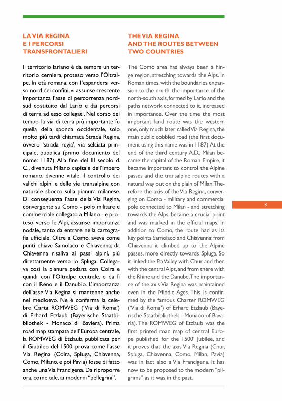
LA VIA REGINAE I PERCORSITRANSFRONTALIERI
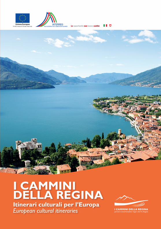
Il territorio lariano è da sempre un ter-ritorio cerniera, proteso verso l’Oltral-pe. In età romana, con l’espandersi ver-so nord dei confini, vi assunse crescente importanza l’asse di percorrenza nord-sud costituito dal Lario e dai percorsi di terra ad esso collegati. Nel corso del tempo la via di terra più importante fu quella della sponda occidentale, solo molto più tardi chiamata Strada Regina, ovvero ‘strada regia’, via selciata prin-cipale, pubblica (primo documento del nome: 1187). Alla fine del III secolo d. C., divenuta Milano capitale dell’Impero romano, divenne vitale il controllo dei valichi alpini e delle vie transalpine con naturale sbocco sulla pianura milanese. Di conseguenza l’asse della Via Regina, convergente su Como - polo militare e commerciale collegato a Milano - e pro-teso verso le Alpi, assunse importanza nodale, tanto da entrare nella cartogra-fia ufficiale. Oltre a Como, aveva come punti chiave Samolaco e Chiavenna; da Chiavenna risaliva ai passi alpini, più direttamente verso lo Spluga. Collega-va così la pianura padana con Coira e quindi con l’Oltralpe centrale, e da lì con il Reno e il Danubio. L’importanza dell’asse Via Regina si mantenne anche nel medioevo. Ne è conferma la cele-bre Carta ROMWEG (‘Via di Roma’) di Erhard Etzlaub (Bayerische Staatbi-bliothek - Monaco di Baviera). Prima road map stampata dell’Europa centrale, la ROMWEG di Etzlaub, pubblicata per il Giubileo del 1500, prova come l’asse Via Regina (Coira, Spluga, Chiavenna, Como, Milano, e poi Pavia) fosse di fatto anche una Via Francigena. Da riproporre ora, come tale, ai moderni “pellegrini”.
THE VIA REGINAAND THE ROUTES BETWEEN TWO COUNTRIES
The Como area has always been a hin-ge region, stretching towards the Alps. In Roman times, with the boundaries expan-sion to the north, the importance of the north-south axis, formed by Lario and the paths network connected to it, increased in importance. Over the time the most important land route was the western one, only much later called Via Regina, the main public cobbled road (the first docu-ment using this name was in 1187). At the end of the third century A.D., Milan be-came the capital of the Roman Empire, it became important to control the Alpine passes and the transalpine routes with a natural way out on the plain of Milan. The-refore the axis of the Via Regina, conver-ging on Como - military and commercial pole connected to Milan - and stretching towards the Alps, became a crucial point and was marked in the official maps. In addition to Como, the route had as its key points Samolaco and Chiavenna; from Chiavenna it climbed up to the Alpine passes, more directly towards Spluga. So it linked the Po Valley with Chur and then with the central Alps, and from there with the Rhine and the Danube. The importan-ce of the axis Via Regina was maintained even in the Middle Ages. This is confir-med by the famous Charter ROMWEG (‘Via di Roma’) of Erhard Etzlaub (Baye-rische Staatbibliothek - Monaco of Bava-ria). The ROMWEG of Etzlaub was the first printed road map of central Euro-pe published for the 1500’ Jubilee, and it proves that the axis Via Regina (Chur, Spluga, Chiavenna, Como, Milan, Pavia) was in fact also a Via Francigena. It has now to be proposed to the modern “pil-grims” as it was in the past.
4
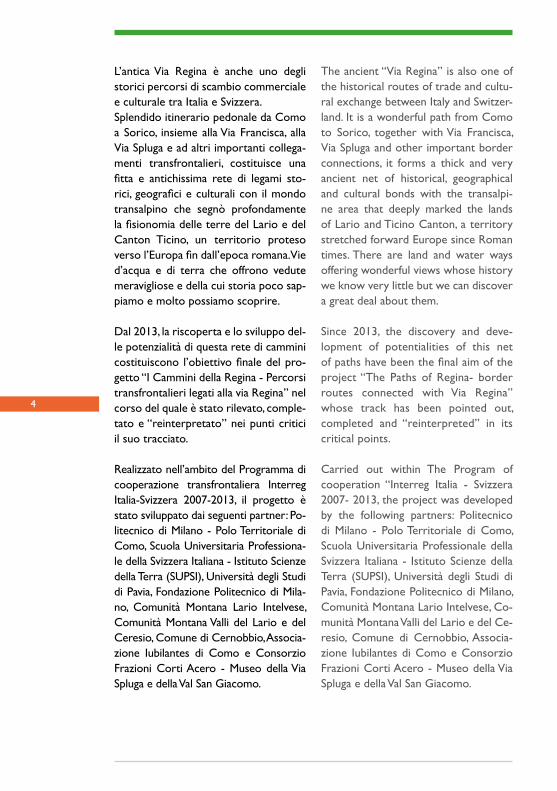
The ancient “Via Regina” is also one of the historical routes of trade and cultu-ral exchange between Italy and Switzer-land. It is a wonderful path from Como to Sorico, together with Via Francisca, Via Spluga and other important border connections, it forms a thick and very ancient net of historical, geographical and cultural bonds with the transalpi-ne area that deeply marked the lands of Lario and Ticino Canton, a territory stretched forward Europe since Roman times. There are land and water ways offering wonderful views whose history we know very little but we can discover a great deal about them.
Since 2013, the discovery and deve-lopment of potentialities of this net of paths have been the final aim of the project “The Paths of Regina- border routes connected with Via Regina” whose track has been pointed out, completed and “reinterpreted” in its critical points.
Carried out within The Program of cooperation “Interreg Italia - Svizzera 2007- 2013, the project was developed by the following partners: Politecnico di Milano - Polo Territoriale di Como, Scuola Universitaria Professionale della Svizzera Italiana - Istituto Scienze della Terra (SUPSI), Università degli Studi di Pavia, Fondazione Politecnico di Milano, Comunità Montana Lario Intelvese, Co-munità Montana Valli del Lario e del Ce-resio, Comune di Cernobbio, Associa-zione Iubilantes di Como e Consorzio Frazioni Corti Acero - Museo della Via Spluga e della Val San Giacomo.
L’antica Via Regina è anche uno degli storici percorsi di scambio commerciale e culturale tra Italia e Svizzera.Splendido itinerario pedonale da Como a Sorico, insieme alla Via Francisca, alla Via Spluga e ad altri importanti collega-menti transfrontalieri, costituisce una fitta e antichissima rete di legami sto-rici, geografici e culturali con il mondo transalpino che segnò profondamente la fisionomia delle terre del Lario e del Canton Ticino, un territorio proteso verso l’Europa fin dall’epoca romana. Vie d’acqua e di terra che offrono vedute meravigliose e della cui storia poco sap-piamo e molto possiamo scoprire.
Dal 2013, la riscoperta e lo sviluppo del-le potenzialità di questa rete di cammini costituiscono l’obiettivo finale del pro-getto “I Cammini della Regina - Percorsi transfrontalieri legati alla via Regina” nel corso del quale è stato rilevato, comple-tato e “reinterpretato” nei punti critici il suo tracciato.
Realizzato nell’ambito del Programma di cooperazione transfrontaliera Interreg Italia-Svizzera 2007-2013, il progetto è stato sviluppato dai seguenti partner: Po-litecnico di Milano - Polo Territoriale di Como, Scuola Universitaria Professiona-le della Svizzera Italiana - Istituto Scienze della Terra (SUPSI), Università degli Studi di Pavia, Fondazione Politecnico di Mila-no, Comunità Montana Lario Intelvese, Comunità Montana Valli del Lario e del Ceresio, Comune di Cernobbio, Associa-zione Iubilantes di Como e Consorzio Frazioni Corti Acero - Museo della Via Spluga e della Val San Giacomo.
5
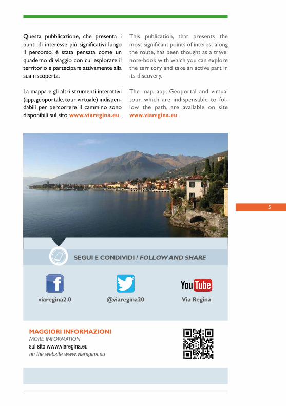
This publication, that presents the most significant points of interest along the route, has been thought as a travel note-book with which you can explore the territory and take an active part in its discovery.
The map, app, Geoportal and virtual tour, which are indispensable to fol-low the path, are available on site www.viaregina.eu.
MAGGIORI INFORMAZIONIMORE INFORMATIONsul sito www.viaregina.euon the website www.viaregina.eu
SEGUI E CONDIVIDI / FOLLOW AND SHARE
@viaregina20viaregina2.0 Via Regina
Questa pubblicazione, che presenta i punti di interesse più significativi lungo il percorso, è stata pensata come un quaderno di viaggio con cui esplorare il territorio e partecipare attivamente alla sua riscoperta.
La mappa e gli altri strumenti interattivi (app, geoportale, tour virtuale) indispen-dabili per percorrere il cammino sono disponibili sul sito www.viaregina.eu.

6
7
LA VIA REGINA

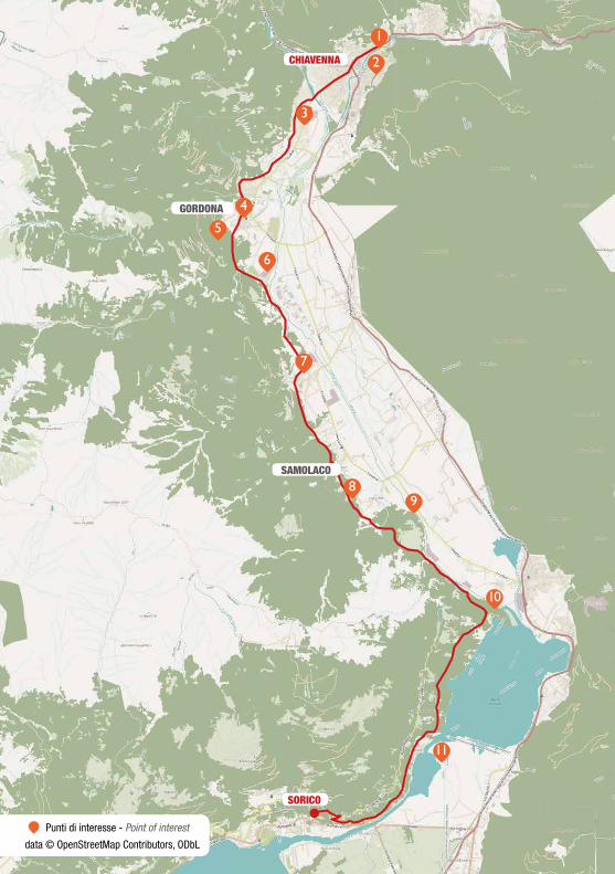
CHIAVENNA
SAN GIACOMO FILIPPO
CAMPODOLCINO 32
5
4
6
7
8
9
10
1
Punti di interesse - Point of interest
data © OpenStreetMap Contributors, ODbL
9
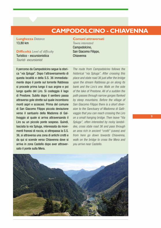
CAMPODOLCINO - CHIAVENNA
Il percorso da Campodolcino segue la stori-ca “via Spluga”. Dopo l’attraversamento di questa località e della S.S. 36 immediata-mente dopo il ponte sul torrente Rabbiosa si procede prima lungo il suo argine e poi lungo quello del Liro. Si costeggia il lago di Prestone. Subito dopo il sentiero passa attraverso gole strette sul quale incombono monti aspri e scoscesi. Prima del comune di San Giacomo Filippo piccola deviazione verso il santuario della Madonna di Gal-livaggio al quale si arriva attraversando il Liro su un piccolo ponte sospeso. Quindi, lasciata la via Spluga, interessata da movi-menti franosi di roccia, si oltrepassa la S.S. 36, si attraversa una zona di antichi crotti e da qui si scende verso Chiavenna dove si arriva in zona Castello dopo aver attraver-sato il ponte sulla Mera.
The route from Campodolcino follows the historical “via Spluga”. After crossing this place and state road 36 just after the bridge upon the stream Rabbiosa go on along its bank and the Liro’s one. Walk on the side of the lake of Prestone. All of a sudden the path passes through narrow gorges flanked by steep mountains. Before the village of San Giacomo Filippo there is a short diver-sion to the Sanctuary of Madonna di Galli-vaggio that you can reach crossing the Liro on a small hanging bridge. Then leave “Via Spluga”, often interested by rocky landsli-des, cross state road 36 and pass through an area rich in ancient “crotti” (caves) and from here go down towards Chiavenna, walk on the bridge to cross the Mera and you arrive near Castello.
Lunghezza Distance 13,80 km
Difficoltà Level of difficultyTuristico - escursionisticaTourist- excursionist
Comuni attraversati Towns interestedCampodolcino,San Giacomo Filippo,Chiavenna
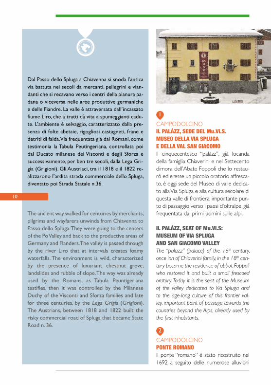
CAMPODOLCINOIL PALÀZZ, SEDE DEL Mu.Vi.S.MUSEO DELLA VIA SPLUGAE DELLA VAL SAN GIACOMOIl cinquecentesco “palàzz”, già locanda della famiglia Chiaverini e nel Settecento dimora dell’Abate Foppoli che lo restau-rò ed eresse un piccolo oratorio affresca-to, è oggi sede del Museo di valle dedica-to alla Via Spluga e alla cultura secolare di questa valle di frontiera, importante pun-to di passaggio verso i paesi d’oltralpe, già frequentata dai primi uomini sulle alpi.
IL PALÀZZ, SEAT OF Mu.Vi.S:MUSEUM OF VIA SPLUGAAND SAN GIACOMO VALLEYThe “palazz” (palace) of the 16th century, once inn of Chiaverini family, in the 18th cen-tury became the residence of abbot Foppoli who restored it and built a small frescoed oratory. Today it is the seat of the Museum of the valley dedicated to Via Spluga and to the age-long culture of this frontier val-ley, important point of passage towards the countries beyond the Alps, already used by the first inhabitants.
CAMPODOLCINOPONTE ROMANOIl ponte “romano” è stato ricostruito nel 1692 a seguito delle numerose alluvioni
1
2
Dal Passo dello Spluga a Chiavenna si snoda l’antica via battuta nei secoli da mercanti, pellegrini e vian-danti che si recavano verso i centri della pianura pa-dana o viceversa nelle aree produttive germaniche e delle Fiandre. La valle è attraversata dall’incassato fiume Liro, che a tratti dà vita a spumeggianti cadu-te. L’ambiente è selvaggio, caratterizzato dalla pre-senza di folte abetaie, rigogliosi castagneti, frane e detriti di falda. Via frequentata già dai Romani, come testimonia la Tabula Peutingeriana, controllata poi dal Ducato milanese dei Visconti e degli Sforza e successivamente, per ben tre secoli, dalla Lega Gri-gia (Grigioni). Gli Austriaci, tra il 1818 e il 1822 re-alizzarono l’ardita strada commerciale dello Spluga, diventato poi Strada Statale n.36.
The ancient way walked for centuries by merchants, pilgrims and wayfarers unwinds from Chiavenna to Passo dello Spluga. They were going to the centers of the Po Valley and back to the productive areas of Germany and Flanders. The valley is passed through by the river Liro that at intervals creates foamy waterfalls. The environment is wild, characterized by the presence of luxuriant chestnut grove, landslides and rubble of slope. The way was already used by the Romans, as Tabula Peuntigeriana testifies, then it was controlled by the Milanese Duchy of the Visconti and Sforza families and late for three centuries, by the Lega Grigia (Grigioni). The Austrians, between 1818 and 1822 built the risky commercial road of Spluga that became State Road n. 36.
10

11
del torrente Rabbiosa, nel punto dove i romani guadavano il corso d’acqua. Stori-co passaggio obbligato delle vie che por-tano al Passo dello Spluga. Dietro il ponte si apre una forra, detta Caurga, con una bella cascata e numerose marmitte fluviali.
ROMAN BRIDGEThe ”Roman” bridge was rebuilt in 1692 as a consequence of the numerous floods of the stream Rabbiosa, in the same point where the Romans forded the water-course. It was the historical fixed passage of the ro-ads leading to Passo dello Spluga. Behind the bridge there is a gorge, called Caurga, with a beautiful waterfall and many river pot-holes.
CAMPODOLCINOLA CHIESA PARROCCHIALEMerita una visita la Chiesa di San Giovan-ni Battista, eretta nel ‘400, consacrata nel 1528 e ampliata nel 1844. Al suo interno fanno bella figura i tre altari barocchi di ottima fattura e la tavola lignea del XV secolo dipinta a tempera da un anonimo di scuola lombarda, raffigurante la Ma-donna in trono con Gesù Bambino.
THE PARISH CHURCHThe Church of San Giovanni Battista deser-ves a visit. It was built in the 15th century, con-secrated in 1528 and enlarged in 1844. In-side there are three beautiful baroque altars
and a wooden tempera of the 15th century by an anonym of Lombard school, represen-ting an enthroned Madonna with Child.
CAMPODOLCINOLA CENTRALE DI GIO PONTIAll’inizio della piana di Campodolcino vi è una piccola diga costruita nel 1927, nei pressi della quale sorge la centrale idroe-lettrica progetta dall’architetto Gio Ponti e realizzata all’inizio degli anni Cinquanta. In Valle Spluga sono numerose le opere di captazione e di sfruttamento dell’ener-gia idroelettrica.
THE HYDRO - ELECTRIC POWERPLANT BY GIO PONTIAt the beginning of the plain of Campodol-cino there is a small dam of 1927 and near it is the hydro-electric power plant designed by architect Gio Ponti and built at the be-ginning of the 1950s. In Valle Spluga there are many works of getting and exploitation of hydro-electric energy.
SAN GIACOMO FILIPPOLO STUTZ E LA SCRIBAITAIl contrafforte roccioso dello Stutz pre-senta vicino al fiume Liro una parete ver-ticale di gneiss, chiamata “Scribàita”, con un’area levigata suddivisa in tasselli cubici, che si susseguono in serie scalare. Era la base per un’iscrizione commemorativa sulla Strada austriaca del 1818, poi rea-lizzata nella variante superiore (1838) e intagliata nella roccia viva.
STUTZ AND “SCRIBAITA”Near the river Liro, the rocky spur of Stutz shows a vertical gneiss wall called “Scribai-ta”, with a smooth area divided into cubic dowels following one another in a gradual sequence. It was the basis of a memorial
3
4
5
12
inscription along the Austrian road of 1818, later built above and cut into the rock.
SAN GIACOMO FILIPPOCIMAGANDA E VHOIl villaggio di Cimaganda è stato costrui-to sul piede di un’imponente paleofrana, da cui l’origine del nome. Le case signorili presentano interessanti pitture murali che raffigurano l’apparizione della Madonna nel vicino Gallivaggio, oltre una passerella sopra il fiume Liro rimangono gli affasci-nanti resti del nucleo rurale Misciò.
CIMAGANDA AND VHOThe village of Cimaganda was built on the foot of an imposing palaeo-landslide and that’s the origin of its name. The luxury hou-ses show interesting wall paintings depicting the Apparition of the Holy Mary in the near Gallivaggio, beyond a footbridge over the river Liro there are still the enchanting re-mains of the rural center of Misciò.
Madonna, gli affreschi del ticinese Care-siano da Cureglia (1605), una tela di Do-menico Caresana (1605); una tela della Crocifissione di Cesare Ligari (1739) e la balconata dell´organo (1673) donata dagli emigranti a Palermo.
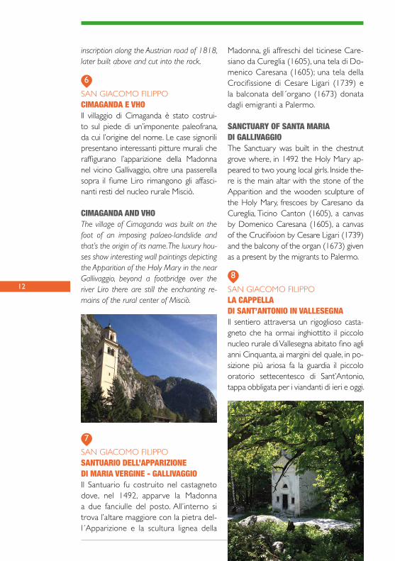
SANCTUARY OF SANTA MARIADI GALLIVAGGIOThe Sanctuary was built in the chestnut grove where, in 1492 the Holy Mary ap-peared to two young local girls. Inside the-re is the main altar with the stone of the Apparition and the wooden sculpture of the Holy Mary, frescoes by Caresano da Cureglia, Ticino Canton (1605), a canvas by Domenico Caresana (1605), a canvas of the Crucifixion by Cesare Ligari (1739) and the balcony of the organ (1673) given as a present by the migrants to Palermo.
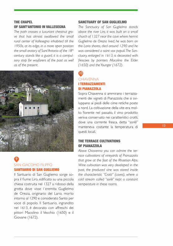
SAN GIACOMO FILIPPOLA CAPPELLA DI SANT’ANTONIO IN VALLESEGNAIl sentiero attraversa un rigoglioso casta-gneto che ha ormai inghiottito il piccolo nucleo rurale di Vallesegna abitato fino agli anni Cinquanta, ai margini del quale, in po-sizione più ariosa fa la guardia il piccolo oratorio settecentesco di Sant’Antonio, tappa obbligata per i viandanti di ieri e oggi.
7
8
6
SAN GIACOMO FILIPPOSANTUARIO DELL’APPARIZIONEDI MARIA VERGINE - GALLIVAGGIOIl Santuario fu costruito nel castagneto dove, nel 1492, apparve la Madonna a due fanciulle del posto. All’interno si trova l’altare maggiore con la pietra del-l´Apparizione e la scultura lignea della
13
SAN GIACOMO FILIPPOSANTUARIO DI SAN GUGLIEMOIl Santuario di San Gugliemo sorge so-pra il fiume Liro, edificato su una piccola chiesa costruita nel 1327 a ridosso della grotta dove visse l´eremita Guglielmo de Orezia, originario del Lario, morto intorno al 1290 e considerato Santo per voce di popolo. Il Santuario, ingrandito nel 1613, è decorato con affreschi dei pittori Macolino il Vecchio (1650) e il Giovane (1672).
THE CHAPELOF SANT’ANTONIO IN VALLESEGNAThe path crosses a luxuriant chestnut gro-ve that has almost swallowed the small rural center of Vallesegna inhabited till the 1950s, at its edge, in a more open position the small oratory of Sant’Antonio of the 18th century stands like a guard, it is a compul-sory stop for wayfarers of the past as well as of the present.
9
10
SANCTUARY OF SAN GUGLIELMO The Sanctuary of San Guglielmo stands above the river Liro, it was built on a small church of 1327 near the cave where hermit Guglielmo de Orezia lived, he was born on the Lario shores, died around 1290 and he was considered a saint vox populi. The San-ctuary, enlarged in 1613, is decorated with frescoes by painters Macolino the Elder (1650) and the Younger (1672).
CHIAVENNAI TERRAZZAMENTIDI PIANAZZOLASopra Chiavenna si ammirano i terrazza-menti dei vigneti di Pianazzola che si svi-luppano ai piedi delle cime retiche poste a nord. La coltivazione della vite era mol-to fiorente nel passato, il vino prodotto veniva conservato nei caratteristici crotti, dove una corrente fresca, detta “sorèl” manteneva costante la temperatura di questi locali.
THE TERRACE CULTIVATIONSOF PIANAZZOLAAbove Chiavenna you can admire the ter-race cultivations of vineyards of Pianazzola that grow at the foot of the Rhaetian Alps. Wine cultivation was very developed in the past, the produced vine was stored inside the characteristic “Crotti” (caves), where a cold stream called “sorèl” kept a constant temperature in these rooms.

14
DATA - DATE _ _ / _ _ / _ _
APPUNTI DI VIAGGIO - TRAVEL NOTES

15
I TUOI SCHIZZI - YOUR SKETCHES
2
SORICO
CHIAVENNA
3
4
5
6
7
89
11
10
1
Punti di interesse - Point of interest
data © OpenStreetMap Contributors, ODbL
GORDONA
SAMOLACO

17
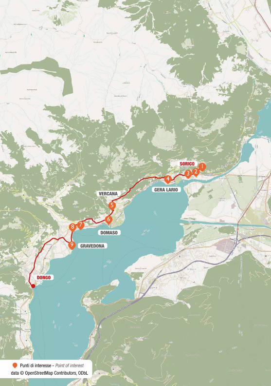
Il percorso, piacevole e ricco di testimo-nianze storiche, si snoda lungo l’antica “Via Francisca” nel Piano di Chiavenna. L’i-tinerario coincide con il “Sentiero storico di valle”, con segnaletica gialla della Comunità montana della Valchiavenna. Da Casenda (località Fontanedo) frazione di Samolaco il percorso presenta qualche difficoltà, ma offre viste spettacolari e luoghi di grande interesse naturalistico e storico. Si percorre ancora la piana di Chiavenna quindi si sale attraverso un imponente scalone in pietra aggirando la dorsale di Monte Berlinghiera. Nel pianoro sottostante il Monte Berlinghiera sorge l’antico sacello di San Fedelino. Il sen-tiero prosegue lungo la sponda occidentale del piccolo lago di Mezzola per giungere a Ponte del Passo, lungo la S.S.340, dove ci si immette sul tracciato della antica Via Regina e si entra in territorio di Sorico.
The pleasant and rich in historical eviden-ces path unwinds along “Via Francisca” in Piano di Chiavenna. The itinerary coincides with the “Historical path of the valley”, with the yellow signs of the “Mountain Com-munity” of Valchiavenna. From Casenda (locality Fontanedo) hamlet of Samolaco the route presents some difficulties, but it offers spectacular views and places of gre-at naturalistic and historical interest. Walk again along the plain of Chiavenna then go up on an imposing flight of stone steps around the ridge of Monte Berlinghiera. On the plain below Mount Berlinghiera there is the ancient small church of San Fedelino. The path continues along the western shore of the small lake of Mezzola as far as Ponte del Passo, along state road 340, where you take the ancient “Via Regina” and you enter the territory of Sorico.
CHIAVENNA - SORICOLunghezza Distance 24,10 km
Difficoltà Level of difficultyTuristico - escursionisticaTourist- excursionist
Comuni attraversati Towns interestedChiavenna, Mese, Gordona,Samolaco, Sorico
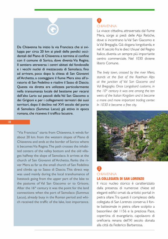
CHIAVENNALa vivace cittadina, attraversata dal fiume Mera, sorge ai piedi delle Alpi Retiche, dove si incontrano la Val San Giacomo e la Val Bregaglia. Già dogana longobarda, e nel X secolo fra le dieci ‘chiuse’ del Regno Italico, diventa un sempre più importante centro commerciale. Nel 1030 diviene libero Comune.
The lively town, crossed by the river Mera, stands at the foot of the Raethian Alps at the junction of Val San Giacomo and Val Bregaglia. Once Longobard customs, in the 10th century it was one among the ten weirs of the Italian Kingdom and it became a more and more important trading center. In 1030 it became a free city.
1
2
Da Chiavenna ha inizio la via Francisca che si svi-luppa per circa 20 km ai piedi delle pendici occi-dentali del Piano di Chiavenna e termina al confine con il comune di Sorico, dove diventa Via Regina. Il sentiero attraversa i centri abitati del fondovalle e i vecchi nuclei di mezzacosta di Samolaco, fino ad arrivare, poco dopo la chiesa di San Giovanni all’Archetto, a costeggiare il fiume Mera sino all’o-ratorio di San Fedelino e risalire il Sasso di Dascio. Questa via diretta era utilizzata particolarmente nella transumanza locale del bestiame per recarsi dall’alto Lario sui pascoli della Val San Giacomo o dei Grigioni e per i collegamenti terrestri dei suoi territori, dopo il declino nel XVI secolo del porto di Samolaco (Summus Lacus) già attivo in epoca romana, che riceveva il traffico lacustre.
“Via Francisca” starts from Chiavenna, it winds for about 20 km. from the western slopes of Piano di Chiavenna and ends at the border of Sorico where it becomes Via Regina. The path crosses the inhabi-ted centers of the valley bottom and the old villa-ges halfway the slope of Samolaco. It arrives at the church of San Giovanni all’Archetto, flanks the ri-ver Mera as far as the small church of San Fedelino and climbs up to Sasso di Dascio. This direct way was used mainly during the local transhumance of livestock going from the upper part of the lake to the pastures of Val San Giacomo or to Grisons. After the 16th century it was the point for the land connections when the port of Samolaco (Summus Lacus), already busy in the Roman period and whi-ch received the traffic of the lake, lost importance.
CHIAVENNALA COLLEGIATA DI SAN LORENZOIl ricco nucleo storico è caratterizzato dalla presenza di numerose chiese ed eleganti edifici ornati da artistici portali in pietra ollare. Tra questi il complesso della collegiata di San Lorenzo conserva il fon-te battesimale in pietra ollare scolpito a bassorilievi del 1156 e la preziosa Pace, copertina di evangelario, capolavoro di oreficeria renana dell’XI secolo donata alla città da Federico Barbarossa.
18

19
THE COLLEGIATE CHURCH OF SAN LORENZOThe rich historical center is characterized by the presence of numerous churches and elegant buildings decorated with artistic portals in “pietra ollare” (chlori-te-schist), among them is the complex of collegiate church of San Lorenzo that keeps a Font carved out in “pietra ollare” of 1156 and the precious Peace, an evan-geliary- cover, masterpiece of the Rhine goldsmith’s art of the 11th century given to the city by emperor Federico I.
GORDONAIL COLLE DI SANTA CATERINA AL CASTELLOSu una piccola altura che domina il centro di Gordona, si staglia la piccola chiesa di Santa Caterina al Castello, un tempo for-tificata e fatta edificare dal vescovo coma-sco Bonifacio nel 1350 insieme al castello distrutto dai Grigioni due secoli dopo.
THE HILL OF SANTA CATERINA AL CASTELLO The small church of Santa Caterina al Ca-stello stands on top of a hill dominating the center of Gordona. The bishop of Como Bonifacio had it built and fortified in 1350 together with the castle destroyed by the Grisons two centuries later.
GORDONA LA CASCATA DELLA BOGIAPrima di arrivare in paese, il sentiero attra-versa una passerella che sostituisce il pon-te in pietra a tre arcate di origine medieva-le, distrutto trent’anni, fa ai piedi del quale si trova un’ampia pozza fluviale. Il torrente Boggia è famoso per avere scavato nume-rose marmitte che sono oggi frequentate dagli appassionati di Canyoning.
WATERFALL OF BOGIA Before arriving at the village of Gordona the path goes along a footbridge that substitu-tes the three arches stone bridge of medie-val origin destroyed thirty years ago. At the foot of the bridge there is a wide river pond. The stream Boggia is famous because it dug numerous pot-holes that today attract many Canyoning fans.
GORDONALA TORRE DI SEGNAMEAl di sopra della vasta piana della Cesura si erge su uno sperone roccioso la tor-re di Segname, una possente struttura in pietra a secco la cui costruzione risale probabilmente al IX o X secolo. Vi si ac-cedeva alla parte sommitale tramite una scala di legno esterna e mobile. La fun-zione principale era quella di stazione di segnalazione fra Milano e Chiavenna.
SEGNAME TOWERSegname tower stands on a rocky spur abo-ve the wide plain of Cesura. It is a powerful dry stone structure whose building dates
3
4
5
20
back probably to the 9th or 10th century. Once you could enter the upper part by an external and movable ladder. It was mainly used as a signaling place between Milan and Chiavenna.
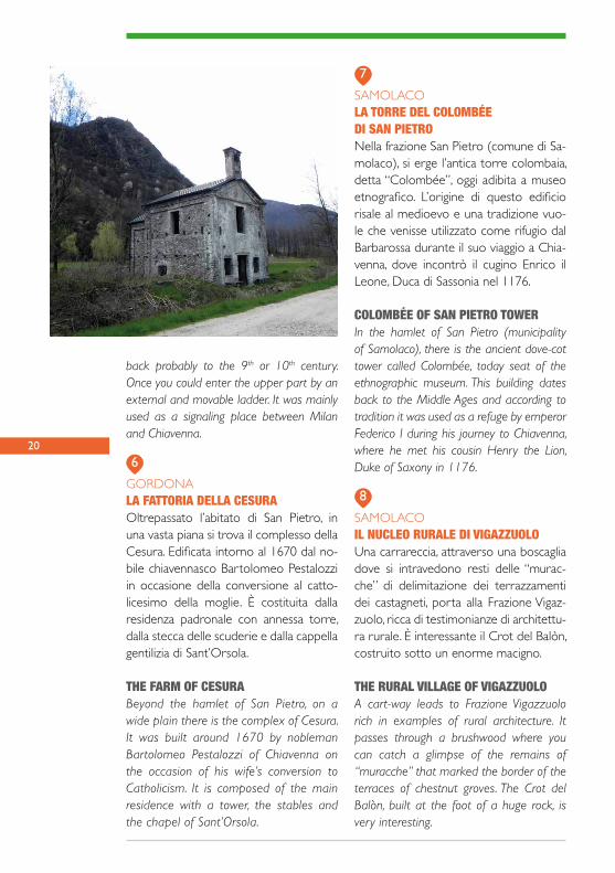
GORDONALA FATTORIA DELLA CESURAOltrepassato l’abitato di San Pietro, in una vasta piana si trova il complesso della Cesura. Edificata intorno al 1670 dal no-bile chiavennasco Bartolomeo Pestalozzi in occasione della conversione al catto-licesimo della moglie. È costituita dalla residenza padronale con annessa torre, dalla stecca delle scuderie e dalla cappella gentilizia di Sant’Orsola.
THE FARM OF CESURABeyond the hamlet of San Pietro, on a wide plain there is the complex of Cesura. It was built around 1670 by nobleman Bartolomeo Pestalozzi of Chiavenna on the occasion of his wife’s conversion to Catholicism. It is composed of the main residence with a tower, the stables and the chapel of Sant’Orsola.
SAMOLACOLA TORRE DEL COLOMBÉE DI SAN PIETRONella frazione San Pietro (comune di Sa-molaco), si erge l’antica torre colombaia, detta “Colombée”, oggi adibita a museo etnografico. L’origine di questo edificio risale al medioevo e una tradizione vuo-le che venisse utilizzato come rifugio dal Barbarossa durante il suo viaggio a Chia-venna, dove incontrò il cugino Enrico il Leone, Duca di Sassonia nel 1176.
COLOMBÉE OF SAN PIETRO TOWERIn the hamlet of San Pietro (municipality of Samolaco), there is the ancient dove-cot tower called Colombée, today seat of the ethnographic museum. This building dates back to the Middle Ages and according to tradition it was used as a refuge by emperor Federico I during his journey to Chiavenna, where he met his cousin Henry the Lion, Duke of Saxony in 1176.
SAMOLACOIL NUCLEO RURALE DI VIGAZZUOLOUna carrareccia, attraverso una boscaglia dove si intravedono resti delle “murac-che” di delimitazione dei terrazzamenti dei castagneti, porta alla Frazione Vigaz-zuolo, ricca di testimonianze di architettu-ra rurale. È interessante il Crot del Balòn, costruito sotto un enorme macigno.
THE RURAL VILLAGE OF VIGAZZUOLOA cart-way leads to Frazione Vigazzuolo rich in examples of rural architecture. It passes through a brushwood where you can catch a glimpse of the remains of “muracche” that marked the border of the terraces of chestnut groves. The Crot del Balòn, built at the foot of a huge rock, is very interesting.
6
7
8

21
SAMOLACOLE “CALCHERE” E LA CHIESA DI SAN GIOVANNI ALL’ARCHETTODopo avere abbandonato il percorso che affianca il fiume Mera, si trovano i resti della chiesa di San Giovanni all’Ar-chetto, distrutta nel primo Seicento, rico-struita nel 1627 e poi abbandonata nel XIX secolo, e i resti di due fornaci da calce (“calchere”) di cui è documentata l’attività fino al XVII secolo.
THE “CALCHERE” AND THE CHURCHOF SAN GIOVANNI ALL’ARCHITETTONot far from the way on the side of the river Mera, there are the remains of the chur-ch of San Giovanni all’Archetto, it was de-stroyed at the beginning of the 17th century, rebuilt in 1627 and then abandoned in the 19th century. We can see also the remains of two limekilns (calchere) whose activity was documented till the 17th century.
SORICO
ORATORY OF SAN FEDELINOProbably built in the 10th century, is one of the most ancient Romanesque architectu-res in the Como area. The building is com-posed of a square hall with a semicircular apse and inside it keeps important fresco-es belonging to the original decoration.
VERCEIA, DUBINO E SORICOPIAN DI SPAGNAOASI DELLE MIGRAZIONISopra il Sasso di Dascio si ammira il pae-saggio della Riserva Naturale Pian di Spa-gna - Lago di Mezzola. Si tratta di un sito di importanza comunitaria (S.I.C.), compre-so tra il territorio di Sorico e di Dubino, molto frequentato dall’avifauna migratoria. Il territorio è costituito in prevalenza da un’ampia esondazione del fiume Adda do-minata da canneti, boschi misti di latifoglie, ampie zone agricole.
PIAN DI SPAGNAOASIS OF MIGRATIONS From Sasso di Dascio you can admire the landscape of the Natural Reserve Pian di Spagna - Lago di Mezzola, a damp area of international interest, between the ter-ritories of Sorico and Dubino and it is a favourite place of the migratory birds. The territory is mainly composed of a wide flo-od of the river Adda with beds of reeds, mixed woods of hardwood and large agri-cultural areas.
9
11
10
SORICOORATORIO DI SAN FEDELINOCostruito probabilmente nel X secolo, è una delle più antiche architetture romani-che comasche. L’edificio è composto da un’aula quadrata con abside semicircolare e conserva al suo interno importanti affre-schi risalenti all’originaria decorazione.

22
DATA - DATE _ _ / _ _ / _ _
APPUNTI DI VIAGGIO - TRAVEL NOTES

23
I TUOI SCHIZZI - YOUR SKETCHES
DONGO
SORICO
GERA LARIOVERCANA
DOMASO
123
4
5
8
9
67
GRAVEDONA
Punti di interesse - Point of interest
data © OpenStreetMap Contributors, ODbL

25
SORICO - DONGO
Da Sorico sul tracciato della antica Via Re-gina, si arriva a Gera Lario e ad Aurogna, frazione del comune di Trezzone. Il percor-so si svolge su sentieri, mulattiere selciate, strade asfaltate, e in parte su vie urbane. Tutto questo tratto oltre ad essere di note-vole bellezza panoramica permette di am-mirare apprezzabili chiese e alcuni nuclei montani di impianto tradizionale, e risulta tra i più ricchi di testimonianze artistiche e storiche dell’alto lago.
From Sorico on the track of the ancient “Via Regina” you arrive at Gera Lario and at Aurogna, hamlet of Trezzone. The route unwinds on paths, mule-tracks, roads and on some pieces of streets. This part of the itinerary, beside being of a remarkable pa-noramic beauty, allows the tourists to admi-re significant churches and some traditional mountain hamlets, it is among the richest ones in artistic and historical evidences in the upper part of the lake.
Lunghezza Distance 17,50 km
Difficoltà Level of difficultyTuristico - escursionisticaTourist- excursionist
Comuni attraversati Towns interestedSorico, Gera Lario, Trezzone, Vercana, Domaso, Gravedona e Uniti (nelle frazioni di Gravedonae Consiglio di Rumo), Dongo

26
Il percorso prende avvio dalla chiesa di San Miro, in posizione suggestiva sopra l’abitato di Sorico, e si snoda seguendo un tracciato che alterna sentie-ri a mezza costa e attraversamenti degli insedia-menti nei pressi del lago. Lungo questo itinerario si possono ammirare pregevoli testimonianze di architettura romanica e interessanti edifici rina-scimentali. Inoltre nell’area di Domaso e Vercana si possono osservare numerosi terrazzamenti destinati a vigneti, realizzati prevalentemente con muretti a secco, che costituiscono un elemento si-gnificativo del paesaggio lariano.
The itinerary starts from the church of San Miro in an evocative position above Sorico and winds along a route alternating paths halfway the moun-tain and roads going through the villages near the lake. Along this way you can admire valuable examples of Romanesque architecture and inte-resting buildings of the Renaissance. In the area of Domaso and Vercana there are many terrace cultivations of vineyards, mainly created with dry stone walls that are a characteristic of the lake landscape.
SORICO CHIESA DI SAN MIROLa chiesa, ubicata su un pianoro e colle-gata alla via Regina da una mulattiera, è il frutto delle modifiche eseguite dal XV secolo su un edificio più antico. L’inter-no conserva numerose decorazioni e un ciclo di affreschi di Sigismondo De Magi-stris del 1526.
CHURCH OF SAN MIROThe Church rises on a plateau connected to Via Regina by a mule-track and it is the re-sult of alterations carried out starting from the 15th century on a more ancient building. Inside it keeps many decorations and a se-ries of frescoes by Sigismondo De Magistris dating back to 1526.
1
27
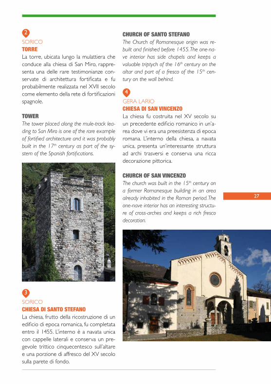
SORICOTORRELa torre, ubicata lungo la mulattiera che conduce alla chiesa di San Miro, rappre-senta una delle rare testimonianze con-servate di architettura fortificata e fu probabilmente realizzata nel XVII secolo come elemento della rete di fortificazioni spagnole.
TOWERThe tower placed along the mule-track lea-ding to San Miro is one of the rare example of fortified architecture and it was probably built in the 17th century as part of the sy-stem of the Spanish fortifications.
CHURCH OF SANTO STEFANOThe Church of Romanesque origin was re-built and finished before 1455. The one-na-ve interior has side chapels and keeps a valuable triptych of the 16th century on the altar and part of a fresco of the 15th cen-tury on the wall behind.
GERA LARIOCHIESA DI SAN VINCENZOLa chiesa fu costruita nel XV secolo su un precedente edificio romanico in un’a-rea dove vi era una preesistenza di epoca romana. L’interno della chiesa, a navata unica, presenta un’interessante struttura ad archi trasversi e conserva una ricca decorazione pittorica.
CHURCH OF SAN VINCENZOThe church was built in the 15th century on a former Romanesque building in an area already inhabited in the Roman period. The one-nave interior has an interesting structu-re of cross-arches and keeps a rich fresco decoration.
2
3
4
SORICOCHIESA DI SANTO STEFANOLa chiesa, frutto della ricostruzione di un edificio di epoca romanica, fu completata entro il 1455. L’interno è a navata unica con cappelle laterali e conserva un pre-gevole trittico cinquecentesco sull’altare e una porzione di affresco del XV secolo sulla parete di fondo.
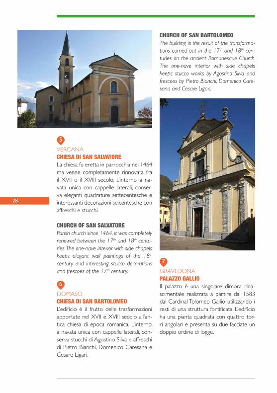
28
VERCANA CHIESA DI SAN SALVATORELa chiesa fu eretta in parrocchia nel 1464 ma venne completamente rinnovata fra il XVII e il XVIII secolo. L’interno, a na-vata unica con cappelle laterali, conser-va eleganti quadrature settecentesche e interessanti decorazioni seicentesche con affreschi e stucchi.
CHURCH OF SAN SALVATOREParish church since 1464, it was completely renewed between the 17th and 18th centu-ries. The one-nave interior with side chapels keeps elegant wall paintings of the 18th century and interesting stucco decorations and frescoes of the 17th century.
DOMASOCHIESA DI SAN BARTOLOMEO L’edificio è il frutto delle trasformazioni apportate nel XVII e XVIII secolo all’an-tica chiesa di epoca romanica. L’interno, a navata unica con cappelle laterali, con-serva stucchi di Agostino Silva e affreschi di Pietro Bianchi, Domenico Caresana e Cesare Ligari.
CHURCH OF SAN BARTOLOMEOThe building is the result of the transforma-tions carried out in the 17th and 18th cen-turies on the ancient Romanesque Church. The one-nave interior with side chapels keeps stucco works by Agostino Silva and frescoes by Pietro Bianchi, Domenico Care-sana and Cesare Ligari.
6
7
5
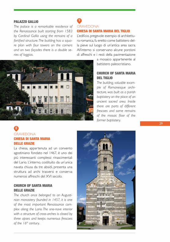
GRAVEDONAPALAZZO GALLIOIl palazzo è una singolare dimora rina-scimentale realizzata a partire dal 1583 dal Cardinal Tolomeo Gallio utilizzando i resti di una struttura fortificata. L’edificio ha una pianta quadrata con quattro tor-ri angolari e presenta su due facciate un doppio ordine di logge.
29
PALAZZO GALLIOThe palace is a remarkable residence of the Renaissance built starting from 1583 by Cardinal Gallio using the remains of a fortified structure. The building has a squa-re plan with four towers on the corners and on two façades there is a double se-ries of loggias.
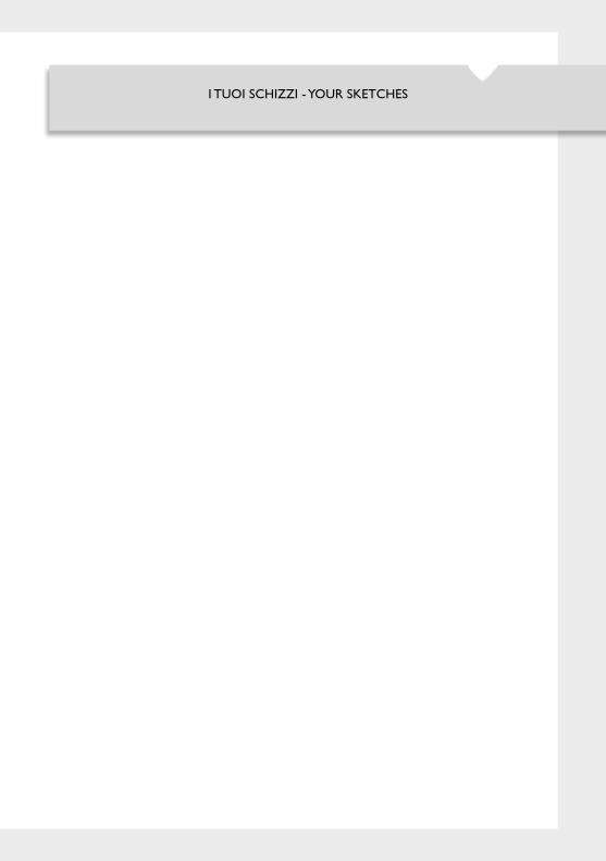
GRAVEDONACHIESA DI SANTA MARIA DEL TIGLIOL’edificio, pregevole esempio di architettu-ra romanica, fu eretto come battistero del-la pieve sul luogo di un’antica area sacra. All’interno si conservano alcune porzioni di affreschi e i resti della pavimentazione
a mosaico appartenente al battistero paleocristiano.
CHURCH OF SANTA MARIA DEL TIGLIOThe building, valuable exam-ple of Romanesque archi-tecture, was built as a parish baptistery on the place of an ancient sacred area. Inside there are parts of different frescoes and some remains of the mosaic floor of the former baptistery.
8
9
GRAVEDONACHIESA DI SANTA MARIADELLE GRAZIELa chiesa, appartenuta ad un convento agostiniano fondato nel 1467, è uno dei più interessanti complessi rinascimentali del Lario. L’interno, costituito da un’unica navata chiusa da tre absidi, presenta una struttura ad archi trasversi e conserva numerosi affreschi del XVI secolo.
CHURCH OF SANTA MARIA DELLE GRAZIEThe church once belonged to an Augusti-nian monastery founded in 1457, it is one of the most important Renaissance com-plex along the Lario. The one-nave interior with a structure of cross-arches is closed by three apses and keeps numerous frescoes of the 16th century.

30
DATA - DATE _ _ / _ _ / _ _
APPUNTI DI VIAGGIO - TRAVEL NOTES
31
I TUOI SCHIZZI - YOUR SKETCHES
MENAGGIO
DONGO
CREMIA
SAN SIRO
1
234
5
6
78
9
10
Punti di interesse - Point of interest
data © OpenStreetMap Contributors, ODbL
33
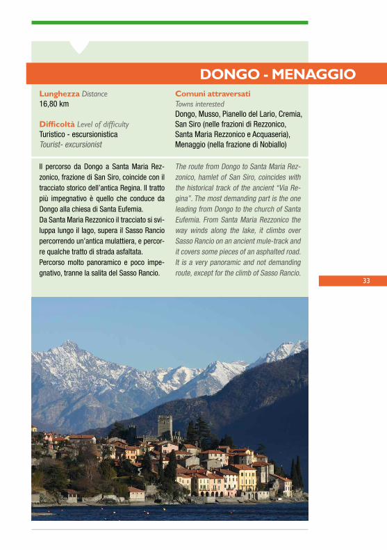
DONGO - MENAGGIO
Il percorso da Dongo a Santa Maria Rez-zonico, frazione di San Siro, coincide con il tracciato storico dell’antica Regina. Il tratto più impegnativo è quello che conduce da Dongo alla chiesa di Santa Eufemia. Da Santa Maria Rezzonico il tracciato si svi-luppa lungo il lago, supera il Sasso Rancio percorrendo un’antica mulattiera, e percor-re qualche tratto di strada asfaltata. Percorso molto panoramico e poco impe-gnativo, tranne la salita del Sasso Rancio.
The route from Dongo to Santa Maria Rez-zonico, hamlet of San Siro, coincides with the historical track of the ancient “Via Re-gina”. The most demanding part is the one leading from Dongo to the church of Santa Eufemia. From Santa Maria Rezzonico the way winds along the lake, it climbs over Sasso Rancio on an ancient mule-track and it covers some pieces of an asphalted road. It is a very panoramic and not demanding route, except for the climb of Sasso Rancio.
Lunghezza Distance 16,80 km
Difficoltà Level of difficultyTuristico - escursionisticaTourist- excursionist
Comuni attraversati Towns interestedDongo, Musso, Pianello del Lario, Cremia, San Siro (nelle frazioni di Rezzonico,Santa Maria Rezzonico e Acquaseria), Menaggio (nella frazione di Nobiallo)
34
Il percorso parte dal centro storico di Dongo e raggiunge Menaggio seguendo un tracciato che si snoda in parte a mezza costa e in parte negli inse-diamenti nei pressi della riva del lago. L’itinerario attraversa l’area del Sasso di Musso, inserita nel cosiddetto Giardino del Merlo, che comprende le antiche cave di marmo, oggi in disuso, la chiesa di Santa Eufemia e i resti del castello di Musso. Lungo il percorso si segnalano diversi edifici religiosi con pregevoli cicli decorativi, interessanti testimonian-ze di architettura fortificata e uno dei più singolari episodi di eclettismo sulle sponde del Lario (Villa Gaeta).
The itinerary starts from the historical center of Dongo and goes as far as Menaggio along a route which is partly half-way the mountain and partly through the villages along the lake shore. It crosses the area of Sasso di Musso inside the “Giardino del Merlo” (Garden of the blackbird), with the ancient marble quarries, the church of Santa Eufemia and the remains of the castle of Musso. Along the way there are many religious buildings with valuable decorations, interesting pieces of fortified architecture and one of the most remarkable examples of eclectic style on the Lario shores: Villa Gaeta.
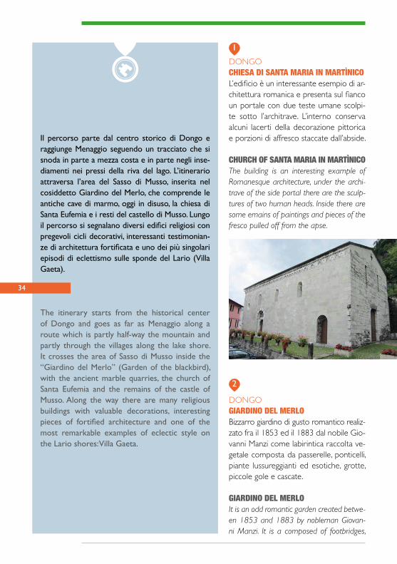
DONGOCHIESA DI SANTA MARIA IN MARTÌNICOL’edificio è un interessante esempio di ar-chitettura romanica e presenta sul fianco un portale con due teste umane scolpi-te sotto l’architrave. L’interno conserva alcuni lacerti della decorazione pittorica e porzioni di affresco staccate dall’abside.
CHURCH OF SANTA MARIA IN MARTÌNICOThe building is an interesting example of Romanesque architecture, under the archi-trave of the side portal there are the sculp-tures of two human heads. Inside there are some emains of paintings and pieces of the fresco pulled off from the apse.
DONGOGIARDINO DEL MERLOBizzarro giardino di gusto romantico realiz-zato fra il 1853 ed il 1883 dal nobile Gio-vanni Manzi come labirintica raccolta ve-getale composta da passerelle, ponticelli, piante lussureggianti ed esotiche, grotte, piccole gole e cascate.
GIARDINO DEL MERLOIt is an odd romantic garden created betwe-en 1853 and 1883 by nobleman Giovan-ni Manzi. It is a composed of footbridges,
1
2
35
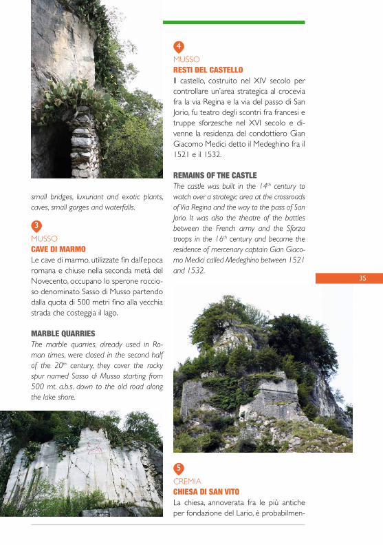
MUSSORESTI DEL CASTELLOIl castello, costruito nel XIV secolo per controllare un’area strategica al crocevia fra la via Regina e la via del passo di San Jorio, fu teatro degli scontri fra francesi e truppe sforzesche nel XVI secolo e di-venne la residenza del condottiero Gian Giacomo Medici detto il Medeghino fra il 1521 e il 1532.
REMAINS OF THE CASTLEThe castle was built in the 14th century to watch over a strategic area at the crossroads of Via Regina and the way to the pass of San Jorio. It was also the theatre of the battles between the French army and the Sforza troops in the 16th century and became the residence of mercenary captain Gian Giaco-mo Medici called Medeghino between 1521 and 1532.
3
4
5
small bridges, luxuriant and exotic plants, caves, small gorges and waterfalls.
MUSSOCAVE DI MARMOLe cave di marmo, utilizzate fin dall’epoca romana e chiuse nella seconda metà del Novecento, occupano lo sperone roccio-so denominato Sasso di Musso partendo dalla quota di 500 metri fino alla vecchia strada che costeggia il lago.
MARBLE QUARRIESThe marble quarries, already used in Ro-man times, were closed in the second half of the 20th century, they cover the rocky spur named Sasso di Musso starting from 500 mt. a.b.s. down to the old road along the lake shore.
CREMIACHIESA DI SAN VITOLa chiesa, annoverata fra le più antiche per fondazione del Lario, è probabilmen-

36
te il frutto di interventi di rifacimento ese-guiti fra il XV ed il XVI secolo. All’interno si conservano dipinti murali risalenti a varie fasi comprese fra il XV e il XVIII secolo.
CHURCH OF SAN VITOThe church, considered one of the most an-cient ones along the lake, is probably the result of remaking carried out between the 15th and 16th centuries. Inside there are wall decorations painted in different periods between the 15th and the 18th centuries.
SAN SIROCASTELLO DI REZZONICOL’edificio è un interessante esempio di ca-stello recinto e fu costruito nel 1363 dai conti Della Torre di Rezzonico. Nel corso dell’Ottocento la struttura, trasformata in residenza, fu oggetto di un restauro di gusto romantico con ampie integrazioni.
REZZONICO CASTLEThe building is an interesting example of walled castle and it was built in 1363 by
the noble family Della Torre of Rezzonico. During the 19th century the estate, transfor-med into a residence, was restored accor-ding to the romantic style.
SAN SIRORECINTO FORTIFICATOIn questa area archeologica si conserva-no i resti di un recinto fortificato ancora non completamente datato, comunque riferibile all’età tardoimperiale o alto medievale e probabilmente destinato al controllo del traffico lungo la via Regina.
FORTIFIED ENCLOSUREIn this archaeological site there are the remains of a fortified enclosure, dating back to the late empire period or to the early Middle Ages and very likely built to watch over the traffic along Via Regina.
SAN SIROCHIESA DI SANTA MARIALa chiesa ha origini romaniche ma fu ri-costruita nel XV secolo a seguito della donazione ai domenicani. L’interno della chiesa, a navata unica con cappelle laterali e abside quadrangolare, è caratterizzato da una pregevole decorazione pittorica rinascimentale.
6
7
8
37
CHURCH OF SANTA MARIAThe church has Romanesque origin but it was rebuilt in the 15th century thanks to the donation to the Dominicans. The inside with a nave, side chapels and a quadrangu-lar apse has a valuable fresco Renaissance decoration.
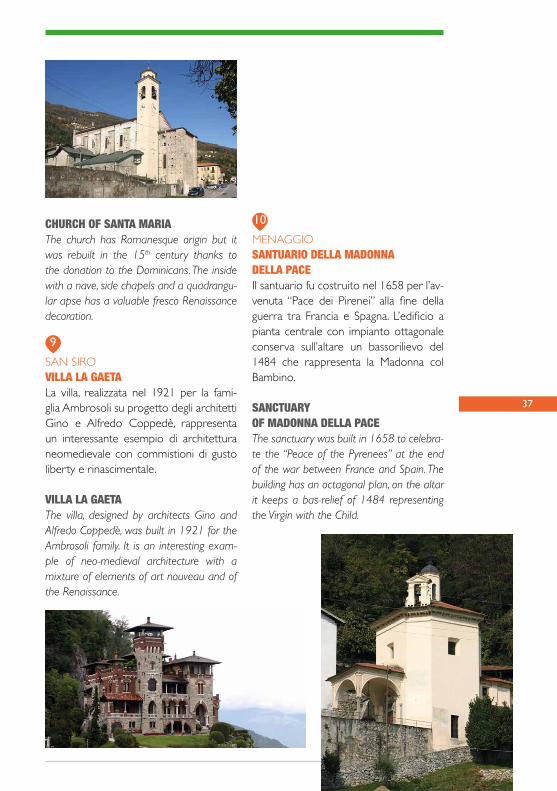
SAN SIROVILLA LA GAETALa villa, realizzata nel 1921 per la fami-glia Ambrosoli su progetto degli architetti Gino e Alfredo Coppedè, rappresenta un interessante esempio di architettura neomedievale con commistioni di gusto liberty e rinascimentale.
VILLA LA GAETAThe villa, designed by architects Gino and Alfredo Coppedè, was built in 1921 for the Ambrosoli family. It is an interesting exam-ple of neo-medieval architecture with a mixture of elements of art nouveau and of the Renaissance.
MENAGGIOSANTUARIO DELLA MADONNA DELLA PACEIl santuario fu costruito nel 1658 per l’av-venuta “Pace dei Pirenei” alla fine della guerra tra Francia e Spagna. L’edificio a pianta centrale con impianto ottagonale conserva sull’altare un bassorilievo del 1484 che rappresenta la Madonna col Bambino.
SANCTUARYOF MADONNA DELLA PACE The sanctuary was built in 1658 to celebra-te the “Peace of the Pyrenees” at the end of the war between France and Spain. The building has an octagonal plan, on the altar it keeps a bas-relief of 1484 representing the Virgin with the Child.
9
10
38
DATA - DATE _ _ / _ _ / _ _
APPUNTI DI VIAGGIO - TRAVEL NOTES

39
I TUOI SCHIZZI - YOUR SKETCHES
MENAGGIO
ARGEGNO
1
23
4
56
8 7
10
GRIANTE
TREMEZZINA
9
Punti di interesse - Point of interest
data © OpenStreetMap Contributors, ODbL

41
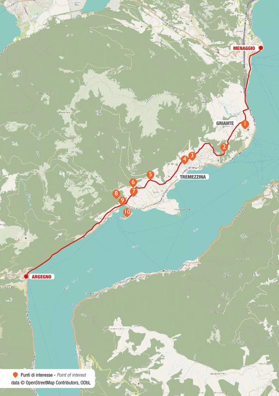
MENAGGIO - ARGEGNO
Il tratto da Menaggio a Lenno è di notevo-le bellezza paesaggistica. Si cammina da Menaggio a Griante sulla statale per poi addentrarci nella valle dei monti di Nava. Il primo tratto, quasi interamente su mu-lattiera, passa vicino ad Acquafredda fino ad arrivare al lago a Spurano, località di Ossuccio. Il tratto da Ossuccio a Colon-no invece prosegue vicino alle sponde del lago e segue il tracciato della Regina medievale. Da Colonno ad Argegno e suc-cessivamente a Brienno si cammina sulla statale 340, molto trafficata.
The route from Menaggio to Lenno offers wonderful views. You walk from Menaggio to Griante along the street then you go inland into the valley of the mountains of Nava. The first part, almost entirely on a mule-track, passes near Acquafredda as far as the lake at Spurano, hamlet of Os-succio. On the contrary, the section from Ossuccio to Colonno goes on near the lake shore and follows the track of the medie-val “Regina”. From Colonno to Argegno and then to Brienno you walk along the very busy state road 340.
Lunghezza Distance 16,20 km
Difficoltà Level of difficultyTuristico - escursionisticaTourist- excursionist
Comuni attraversati Towns interestedMenaggio, Griante, Tremezzina(nelle frazioni Rogaro, Tremezzo,Mezzegra, Lenno, Ossuccio),Sala Comacina, Colonno, Argegno
42
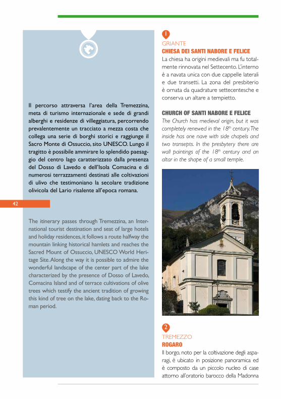
Il percorso attraversa l’area della Tremezzina, meta di turismo internazionale e sede di grandi alberghi e residenze di villeggiatura, percorrendo prevalentemente un tracciato a mezza costa che collega una serie di borghi storici e raggiunge il Sacro Monte di Ossuccio, sito UNESCO. Lungo il tragitto è possibile ammirare lo splendido paesag-gio del centro lago caratterizzato dalla presenza del Dosso di Lavedo e dell’Isola Comacina e di numerosi terrazzamenti destinati alle coltivazioni di ulivo che testimoniano la secolare tradizione olivicola del Lario risalente all’epoca romana.
The itinerary passes through Tremezzina, an Inter-national tourist destination and seat of large hotels and holiday residences, it follows a route halfway the mountain linking historical hamlets and reaches the Sacred Mount of Ossuccio, UNESCO World Heri-tage Site. Along the way it is possible to admire the wonderful landscape of the center part of the lake characterized by the presence of Dosso of Lavedo, Comacina Island and of terrace cultivations of olive trees which testify the ancient tradition of growing this kind of tree on the lake, dating back to the Ro-man period.
GRIANTECHIESA DEI SANTI NABORE E FELICELa chiesa ha origini medievali ma fu total-mente rinnovata nel Settecento. L’interno è a navata unica con due cappelle laterali e due transetti. La zona del presbiterio è ornata da quadrature settecentesche e conserva un altare a tempietto.
CHURCH OF SANTI NABORE E FELICEThe Church has medieval origin, but it was completely renewed in the 18th century. The inside has one nave with side chapels and two transepts. In the presbytery there are wall paintings of the 18th century and an altar in the shape of a small temple.
TREMEZZOROGAROIl borgo, noto per la coltivazione degli aspa-ragi, è ubicato in posizione panoramica ed è composto da un piccolo nucleo di case attorno all’oratorio barocco della Madonna
1
2
43
Nera di Einsiedeln che testimonia le relazioni commerciali con i territori a nord delle Alpi.
ROGAROThe hamlet, known for the asparagus growing, is in a panoramic position and it is composed of a small group of houses around the baro-que oratory of the Madonna Nera of Einsie-deln that testifies the business connections with the territories at north of the Alps.
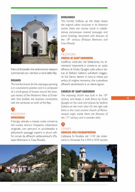
MEZZEGRABONZANIGOIl borgo, ubicato a mezza costa, conserva nel nucleo storico l’impianto urbanistico originale, con percorsi in acciottolato e pittoreschi passaggi coperti, e alcuni edi-fici ornati da affreschi settecenteschi (Pa-lazzo Brentano e Casa Rosati).
BONZANIGOThe hamlet, halfway up the slope, keeps the original urban structure in its historical centre, there are narrow roads in cobble-stones, picturesque covered passages and some buildings decorated with frescoes of the 18th century (Palazzo Brentano and Casa Rosati)
MEZZEGRACHIESA DI SANT’ABBONDIOL’edificio, costruito nel Settecento, ha di-mensioni imponenti e conserva un vasto affresco di Giulio Quaglio sulla volta e sta-tue di Stefano Salterio sull’altare maggio-re. Sul fianco destro si nota la chiesa più antica, di origine romanica, che custodisce affreschi seicenteschi e un altare ligneo.
CHURCH OF SANT’ABBONDIOThe imposing church was built in the 18th century and keeps a wide fresco by Giulio Quaglio on the vault and statues by Stefano Salterio on the main altar. On the right side there is the most ancient church, of Roma-nesque origin, inside there are frescoes of the 17th century and a wooden altar.
LENNOABBAZIA DELL’ACQUAFREDDAL’abbazia fu fondata nel 1143 dai cister-censi e rinnovata fra il XVI e XVII secolo.
3
4
5

44
L’interno della chiesa, a navata unica con due cappelle laterali e abside poligonale, conserva stucchi di Agostino Silva e un ciclo di affreschi seicenteschi di Giovan Mauro della Rovere.
ACQUAFREDDA ABBEYThe abbey was founded by the Cistercians in 1143 and renewed between the 16th and 17th centuries. Inside the church has one nave, two side chapels and a polygonal apse, it keeps stucco works by Agostino Silva and frescoes of the 17th century by Giovan Mauro della Rovere.
OSSUCCIOSACRO MONTE DI OSSUCCIOÈ inserito nella Lista del Patrimonio Mon-diale dell’Umanità dell’UNESCO e com-prende il santuario e 14 cappelle, realiz-zate fra il 1644 ed il 1699, disposte lungo un suggestivo viale e arricchite da statue in terracotta e affreschi che illustrano i Misteri del Rosario.
SACRED MOUNT OF OSSUCCIODeclared a world heritage site by UNESCO, is composed of the Sanctuary and 14 cha-pels built between 1644 and 1699 and placed along an evocative path enriched
with terracotta statues and frescoes repre-senting the Mysteries of Rosary.
OSSUCCIOCHIESA DEI SANTI AGATA E SISINNIO La chiesa ha origini antiche, risalenti ad un primo sacello del VII secolo, ma fu ampliata nel XVI e XVII secolo. L’interno conserva lacerti di dipinti murali riferibili al XII e al XV secolo e un’ara romana del I-II secolo che ricorda il pago degli Au-suciates.
CHURCH OF SANTI AGATA E SISINNIO The Church has ancient origin dating back to the first small chapel of the 7th century, it was enlarged in the 16th and 17th cen-turies. Inside there are remains of frescoes of the 12th and 15th centuries and a Ro-man altar of the 1st / 2nd century with an inscription dedicated to the pagus of the Ausuciates.
6
7

45
OSSUCCIOTORRE DEL SOCCORSO L’edificio, collocato su uno sperone roc-cioso sopra l’abitato di Spurano, corri-sponde ad un’antica torre di segnalazio-ne risalente probabilmente al XII secolo. La struttura fu probabilmente dismessa dopo il 1169 e nel Novecento fu adattata a fini residenziali.
SOCCORSO TOWERThe building, placed on a rocky spur above Spurano, was once an ancient watch tower probably of the 12th century. The structure was probably no longer used after 1169 and in the 20th century it was transformed into a residence.
OSSUCCIOCHIESA DI SAN GIACOMO A SPURANOLa chiesa, interessante esempio di architet-tura romanica, risale probabilmente al seco-lo XI. L’edificio, collocato sopra uno spero-ne roccioso, è composto da un’unica navata con abside semicircolare e conserva al suo interno alcune pitture murali del secolo XI.
CHURCH OF SAN GIACOMO IN SPURANOThe Church is an interesting example of Ro-manesque architecture and probably dates back to the 11th century. The building pla-ced on a rocky spur, is formed by one nave
with a semicircular apse and inside it keeps some wall paintings of the 11th century.
OSSUCCIOISOLA COMACINAL’unica isola del Lario è oggi nota soprat-tutto per il suo interessante patrimonio archeologico e per le case per artisti pro-gettate dall’architetto Pietro Lingeri. In particolare si possono osservare i resti di alcuni edifici religiosi costruiti prima della distruzione dell’isola nel 1169.
COMACINA ISLANDThe only Island of Lake Lario is well known mainly for its interesting archeological he-ritage and for the houses for artists desi-gned by architect Pietro Lingeri. In particular you can see the remains of some religious structures built before the destruction of the island in 1169.
8
9
10

46
DATA - DATE _ _ / _ _ / _ _
APPUNTI DI VIAGGIO - TRAVEL NOTES

47
I TUOI SCHIZZI - YOUR SKETCHES

COMO
ARGEGNO
1
2
3
4
6
7
8
9
10
5
BRIENNO
LAGLIO
CARATE URIO
MOLTRASIO
CERNOBBIO
Punti di interesse - Point of interest
data © OpenStreetMap Contributors, ODbL
49
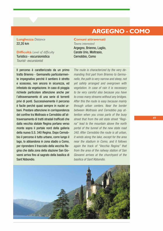
ARGEGNO - COMO
Il percorso è caratterizzato da un primo tratto Brienno - Germanello particolarmen-te impegnativo perché il sentiero è stretto e scosceso, non ancora in sicurezza, ed infestato da vegetazione. In caso di pioggia richiede particolare attenzione anche per l’attraversamento di una serie di torrenti privi di ponti. Successivamente il percorso è facile perché quasi sempre in nuclei ur-bani. Prestare attenzione in corrispondenza del confine tra Moltrasio e Cernobbio all’at-traversamento di tratti stradali trafficati che dalla vecchia statale Regina portano verso monte sopra il portale nord della galleria della nuova S.S. 340 Regina. Dopo Cernob-bio il percorso è tutto urbano, corre lungo il lago, lo abbandona in zona stadio a Como, per riprendere il tracciato della vecchia Re-gina che dalla zona della stazione San Gio-vanni arriva fino al sagrato della basilica di Sant’Abbondio.
The route is characterized by the very de-manding first part from Brienno to Germa-nello, the path is very narrow and steep, not yet safety arranged and overgrown with vegetation. In case of rain it is necessary to be very careful also because you have to cross many streams without any bridges. After this the route is easy because mainly through urban centers. Near the border between Moltrasio and Cernobbio pay at-tention when you cross parts of the busy street that from the old state street “Regi-na” lead to the mountain above the north portal of the tunnel of the new state road 340. After Cernobbio the route is all urban, it winds along the lake, except for the area near the stadium in Como, and it follows again the track of “Vecchia Regina” that from the area of the railway station of San Giovanni arrives at the churchyard of the basilica of Sant’Abbondio.
Lunghezza Distance 22,20 km
Difficoltà Level of difficultyTuristico - escursionisticaTourist- excursionist
Comuni attraversati Towns interestedArgegno, Brienno, Laglio,Carate Urio, Moltrasio,Cernobbio, Como

50
Il percorso parte da Argegno, punto di collega-mento fra il lago e la Valle Intelvi, e si snoda fra i piccoli nuclei ubicati a mezza costa e gli insedia-menti a lago fino a raggiungere il primo bacino attorno al quale si affacciano le città di Como e Cernobbio. Lungo questo itinerario si possono ammirare pregevoli esempi di architettura roma-nica, ville neoclassiche e numerosi affioramenti di una pietra calcarea, denominata Pietra di Moltra-sio, materiale tradizionalmente utilizzato in area lariana per la costruzione di opere murarie, pa-vimentazioni e lastre di copertura dette “piode”.
The route starts from Argegno, the place that connects up the lake and Valle Intelvi, and passes through small hamlets half way the mountain and villages near the lake shore as far as Como and Cernobbio. Along this route you can admire wonderful Romanesque churches and many neoclassic villas. You can also see outcrops of the local stone called “Pietra di Moltrasio” used for many buildings, floors and slabbed for roofs.
BRIENNOCHIESA DEI SANTI NAZARO E CELSOLa chiesa ha origini antiche ma fu ricostru-ita fra il 1615 ed il 1625 ed è composta da un’unica navata con due cappelle laterali arricchite da stucchi e affreschi realizzati nel XVII secolo. Nel coro si conservano interessanti vetrate rinascimentali.
CHURCH OF SANTI NAZARO AND CELSOThe church is of ancient origin, but it was rebuilt between 1615 and 1625. It has one nave with two side chapels rich in stucco works and frescoes of the 17th century. In the choir there are beautiful stained glass windows of the Renaissance period.
BRIENNOEX FILANDAL’antica filanda Comitti, ubicata nei pressi della riva del lago, è un esempio di archeo-logia industriale legata alla tradizione tessi-le lariana ed è composta da un massiccio edificio a pianta rettangolare affiancato da un’alta ciminiera.
FORMER SPINNING MILLThe ancient Comitti spinning mill near the
1
2

51
lake shore is an example of the past tex-tile tradition and it is composed of a huge rectangular building flanked by a soaring chimney.
LAGLIOCHIESA DI SAN GIORGIOLa chiesa, ricostruzione seicentesca di un edificio più antico, è composta da un’unica navata con cappelle laterali decorate nel XVII e nel XVIII secolo. L’oratorio dei Con-fratelli del Santissimo Sacramento custo-
disce un altare in stucco opera di Stefano Salterio, nativo di Laglio, e una pala d’altare di Carlo Innocenzo Carloni.
CHURCH OF SAN GIORGIOThe Church, of ancient origin, was rebuilt in the 17th century. It has one nave with side chapels decorated in the 17th and 18th cen-turies. The Oratory of the Holy Sacrament keeps a stucco altar by Stefano Salterio born in Laglio and an altar piece painted by Carlo Innocenzo Carloni.
CARATE URIOCHIESA DI SANTA MARTALa chiesa, di origine romanica, ha un inter-no a tre navate e conserva alcuni affre-schi del XV secolo e diverse decorazioni e stucchi eseguiti nel corso del XVII seco-lo. A lato del presbiterio vi è l’oratorio, un tempo sede della Confraternita, decora-to da affreschi sulla volta e su una parete.
CHURCH OF SANTA MARTAThe three aisled church of Romanesque ori-gin keeps some frescoes of the 15th century and many stucco decorations of the 17th century. Next to the presbytery there is the Oratory, once seat of the Confraternity, de-corated with frescoes on the vault and on one wall.
3
4
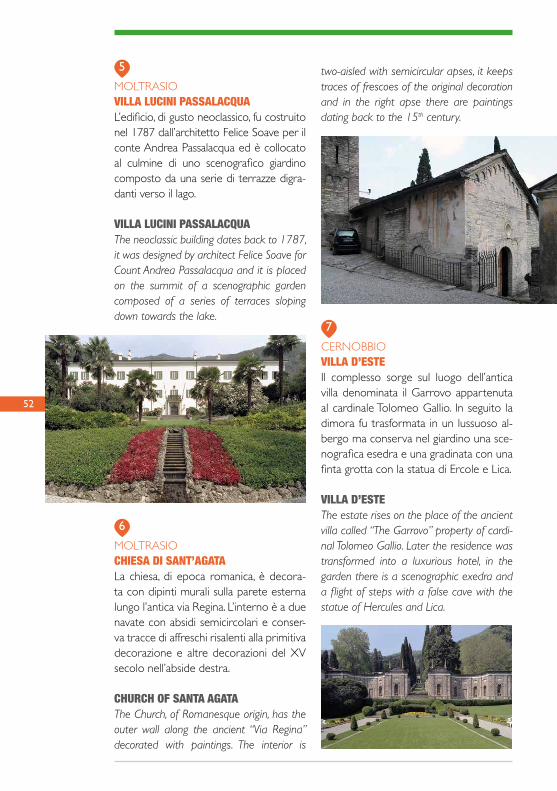
MOLTRASIOVILLA LUCINI PASSALACQUAL’edificio, di gusto neoclassico, fu costruito nel 1787 dall’architetto Felice Soave per il conte Andrea Passalacqua ed è collocato al culmine di uno scenografico giardino composto da una serie di terrazze digra-danti verso il lago.
VILLA LUCINI PASSALACQUAThe neoclassic building dates back to 1787, it was designed by architect Felice Soave for Count Andrea Passalacqua and it is placed on the summit of a scenographic garden composed of a series of terraces sloping down towards the lake.
MOLTRASIOCHIESA DI SANT’AGATALa chiesa, di epoca romanica, è decora-ta con dipinti murali sulla parete esterna lungo l’antica via Regina. L’interno è a due navate con absidi semicircolari e conser-va tracce di affreschi risalenti alla primitiva decorazione e altre decorazioni del XV secolo nell’abside destra.
CHURCH OF SANTA AGATAThe Church, of Romanesque origin, has the outer wall along the ancient “Via Regina” decorated with paintings. The interior is
two-aisled with semicircular apses, it keeps traces of frescoes of the original decoration and in the right apse there are paintings dating back to the 15th century.
CERNOBBIO VILLA D’ESTEIl complesso sorge sul luogo dell’antica villa denominata il Garrovo appartenuta al cardinale Tolomeo Gallio. In seguito la dimora fu trasformata in un lussuoso al-bergo ma conserva nel giardino una sce-nografica esedra e una gradinata con una finta grotta con la statua di Ercole e Lica.
VILLA D’ESTEThe estate rises on the place of the ancient villa called “The Garrovo” property of cardi-nal Tolomeo Gallio. Later the residence was transformed into a luxurious hotel, in the garden there is a scenographic exedra and a flight of steps with a false cave with the statue of Hercules and Lica.
52
5
6
7
53
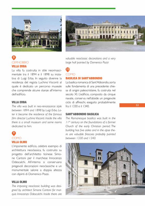
CERNOBBIO VILLA ERBALa villa fu costruita in stile neorinasci-mentale tra il 1894 e il 1898 su inizia-tiva di Luigi Erba. In seguito divenne la residenza del regista Luchino Visconti al quale è dedicato un percorso museale che comprende alcune stanze all’interno dell’edificio.
VILLA ERBAThe villa was built in neo-renaissance style between 1894 and 1898 by Luigi Erba. La-ter it became the residence of the famous film director Luchino Visconti. Inside the villa there is a small museum and some rooms dedicated to him.
COMO VILLA OLMOL’imponente edificio, celebre esempio di architettura neoclassica, fu costruito su progetto dell’architetto ticinese Simo-ne Cantoni per il marchese Innocenzo Odescalchi. All’interno si conservano pregevoli decorazioni neoclassiche e un monumentale salone a doppia altezza con dipinti di Domenico Pozzi.
VILLA OLMOThe imposing neoclassic building was desi-gned by architect Simone Cantoni for mar-quis Innocenzo Odescalchi. Inside there are
valuable neoclassic decorations and a very large hall painted by Domenico Pozzi
COMOBASILICA DI SANT’ABBONDIOLa basilica romanica di Sant’Abbondio, sorta sulle fondamenta di una precedente chie-sa di origini paleocristiane, fu costruita nel secolo XI. L’edificio, composto da cinque navate, conserva nell’abside un pregevole ciclo di affreschi, eseguito probabilmente fra il 1330 e il 1340.
SANT’ABBONDIO BASILICAThe Romanesque basilica was built in the 11th century on the foundations of a former Church of the early Christian period. The building has five aisles and in the apse the-re are valuable frescoes probably painted between 1330 and 1340.
8
9
10

54
DATA - DATE _ _ / _ _ / _ _
APPUNTI DI VIAGGIO - TRAVEL NOTES

55
I TUOI SCHIZZI - YOUR SKETCHES


PERCORSITRANSFRONTALIERIROUTES BETWEEN TWO COUNTRIES
SVIZZERA
876
10
532
1
4
Punti di interesse in territorio italiano - Point of interest in Italy
Punti di interesse nei tratti comuni - Common point of interest
Punti di interesse in territorio svizzero - Point of interest in Switzerland
data © OpenStreetMap Contributors, ODbL
GIUBIASCO
DONGO
STAZZONA
GARZENO
SAN JORIOITALIA
12
34
5
6
79
1
59
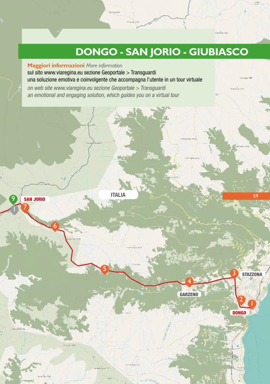
DONGO - SAN JORIO - GIUBIASCOMaggiori informazioni More informationsul sito www.viaregina.eu sezione Geoportale > Transguardiuna soluzione emotiva e coinvolgente che accompagna l’utente in un tour virtuale
on web site www.viaregina.eu sezione Geoportale > Transguardian emotional and engaging solution, which guides you on a virtual tour
60
Il Passo San Jorio fu intensamente frequentato sin dall’antichità, come testimoniano i numero-si ritrovamenti archeologici effettuati in diver-se località del percorso. Questo valico, che mette in comunicazione il bacino del Verbano con quello del Lario, ebbe funzioni molteplici. Preponderante fu la sua importanza strategica, in quanto consentiva di giungere facilmente dalle terre lombarde a Bel-linzona aggirandone le difese, motivo per cui il passo fu regolarmente presidiato e, a partire dalla seconda metà del XIX secolo, fortificato. Non trascurabile anche l’interesse commercia-le che, seppur in modo discontinuo, la via del San Jorio suscitò tra i commercianti comaschi sin dal XV secolo quale collegamento diretto per i mercati del Bellinzonese e della Mesol-cina. Il San Jorio, inoltre, è legato all’economia d’alpeggio e per secoli venne quotidianamente attraversato dagli abitanti della Valle d’Albano che possedevano diversi pascoli sul versante ticinese. Infine non va dimenticato che questa fu una delle vie più utilizzate per il contrabban-do qui documentato sin dal XV secolo.Oggi il Passo San Jorio, con i suoi stupendi paesaggi, è una meta frequentatissima dagli escursionisti.
Passo San Jorio was already intensely popu-lated in ancient times, as it is proved by many archeological finds discovered in different places along the itinerary.This passage, that connects the Verbano ba-sin with Lario, had various functions. Its stra-tegic importance was prevalent as it allowed to easily reach Bellinzona from the Lombard lands, eluding defenses. For this reason the pass was regularly guarded and fortified in the second half of the 19th century. San Jorio’s way aroused as well an important commercial interest, though discontinuously, among the merchants of Como starting from the 15th century, as it was a direct connection with Bellinzona and Mesolcina markets. Pas-so San Jorio is also bound to pasture eco-nomy and for centuries it was crossed daily by the inhabitants of Valle Albano, who had pastures on Ticino side.Finally, not to be forgotten that this was one of the most used ways for smuggling, docu-mented here since the 15th century.Nowadays Passo San Jorio, with its beauti-ful landscapes, is a popular destination for hikers.
61
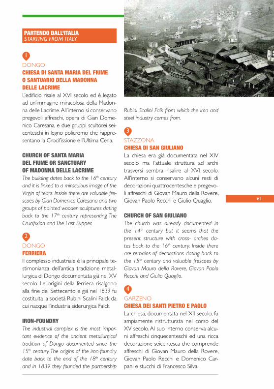
DONGOCHIESA DI SANTA MARIA DEL FIUMEO SANTUARIO DELLA MADONNADELLE LACRIMEL’edificio risale al XVI secolo ed è legato ad un’immagine miracolosa della Madon-na delle Lacrime. All’interno si conservano pregevoli affreschi, opera di Gian Dome-nico Caresana, e due gruppi scultorei sei-centeschi in legno policromo che rappre-sentano la Crocifissione e l’Ultima Cena.
CHURCH OF SANTA MARIA DEL FIUME OR SANCTUARY OF MADONNA DELLE LACRIMEThe building dates back to the 16th century and it is linked to a miraculous image of the Virgin of tears. Inside there are valuable fre-scoes by Gian Domenico Caresana and two groups of painted wooden sculptures dating back to the 17th century representing The Crucifixion and The Last Supper.
DONGOFERRIERA Il complesso industriale è la principale te-stimonianza dell’antica tradizione metal-lurgica di Dongo documentata già nel XV secolo. Le origini della ferriera risalgono alla fine del Settecento e già nel 1839 fu costituita la società Rubini Scalini Falck da cui nacque l’industria siderurgica Falck.
IRON-FOUNDRYThe industrial complex is the most impor-tant evidence of the ancient metallurgical tradition of Dongo documented since the 15th century. The origins of the iron-foundry date back to the end of the 18th century and in 1839 they founded the partnership
Rubini Scalini Falk from which the iron and steel industry comes from.
STAZZONACHIESA DI SAN GIULIANOLa chiesa era già documentata nel XIV secolo ma l’attuale struttura ad archi trasversi sembra risalire al XVI secolo. All’interno si conservano alcuni resti di decorazioni quattrocentesche e pregevo-li affreschi di Giovan Mauro della Rovere, Giovan Paolo Recchi e Giulio Quaglio.
CHURCH OF SAN GIULIANOThe church was already documented in the 14th century but it seems that the present structure with cross- arches da-tes back to the 16th century. Inside there are remains of decorations dating back to the 15th century and valuable frescoes by Giovan Mauro della Rovere, Giovan Paolo Recchi and Giulio Quaglio.
GARZENOCHIESA DEI SANTI PIETRO E PAOLOLa chiesa, documentata nel XII secolo, fu ampiamente ristrutturata nel corso del XV secolo. Al suo interno conserva alcu-ni affreschi cinquecenteschi ed una ricca decorazione seicentesca che comprende affreschi di Giovan Mauro della Rovere, Giovan Paolo Recchi e Domenico Car-pani e stucchi di Francesco Silva.
1
3
4
2
PARTENDO DALL’ITALIASTARTING FROM ITALY

62
CHURCH OF SANTI PIETRO E PAOLOThe Church, documented since the 12th
century, was widely rebuilt during the 15th century. Inside there are frescoes dating back to the 16th century and a rich deco-ration of the 17th century including fresco-es by Giovan Mauro della Rovere, Giovan Paolo Recchi and Domenico Carpani and stucco works by Francesco Silva.
GARZENO, BRENZEGLIOMASUNCaratteristica architettura rurale del ter-ritorio della Val Cavargna e della Valle Albano. L’edificio comprende una stalla e un sovrastante fienile ed è costituito da una struttura muraria in pietra e da un singolare tetto a ripide falde ricoperte di paglia di segale.
MASUNIt is a characteristic rural architecture of the territory of Val Cavargna and of Valle Alba-no. The building is composed of a cowshed and a hayloft over it, it has stone walls and a steep thatched roof.
GARZENOBIVACCO “IL GIOVO”Situato sull’ampia sella erbosa del Motto di Paraone, a cavallo tra la Valle San Jorio e la Valle Albano, il rifugio occupa una ex-ca-serma della Guardia di Finanza, attiva dal 1870 al 1976. Si tratta di un rifugio raggiun-gibile in auto, incustodito, chiuso, al quale si accede chiedendo le chiavi al Comune di Garzeno (0344/88081). Dal pianoro anti-stante l’edificio si gode una splendida vista sul Pizzo di Gino (2245m) e, sulla destra la Cima Verta (2078m), la Cima Pomodoro (1973m), il Mottone di Giumello (2027m), il Passo San Jorio (2014m) e il Monte Mar-montana (2316m)
BIVOUAC “IL GIOVIO”The shelter, placed on the wide grassy sad-dle of Motto di Paraone astride Valle San Jorio and Valle Albano, is located in the for-mer barracks of the Customs Officers, acti-ve from 1870 to 1976. It is a closed and unguarded shelter you reach by car, you can enter asking the keys at the Town Hall of Garzeno (0344/88081). From the plateau in front of the shelter you enjoy a wonderful view of Pizzo di Gino (2245 m.) and on the right of Cima Verta (2078 m.), Cima Pomodoro (1973 m.), Mottone di Giumello (2027 m.), Passo San Jorio (2014 m.) and Monte Marmontana (2316 m.).
56
63
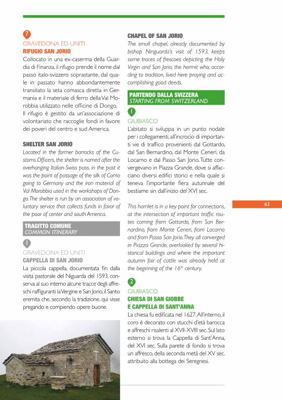
GRAVEDONA ED UNITIRIFUGIO SAN JORIOCollocato in una ex-caserma della Guar-dia di Finanza, il rifugio prende il nome dal passo italo-svizzero soprastante, dal qua-le in passato hanno abbondantemente transitato la seta comasca diretta in Ger-mania e il materiale di ferro della Val Mo-robbia utilizzato nelle officine di Dongo.Il rifugio è gestito da un’associazione di volontariato che raccoglie fondi in favore dei poveri del centro e sud America.
SHELTER SAN JORIOLocated in the former barracks of the Cu-stoms Officers, the shelter is named after the overhanging Italian-Swiss pass, in the past it was the point of passage of the silk of Como going to Germany and the iron material of Val Morobbia used in the workshops of Don-go. The shelter is run by an association of vo-luntary service that collects funds in favor of the poor of center and south America.
GRAVEDONA ED UNITICAPPELLA DI SAN JORIOLa piccola cappella, documentata fin dalla visita pastorale del Niguarda del 1593, con-serva al suo interno alcune tracce degli affre-schi raffiguranti la Vergine e San Jorio, il Santo eremita che, secondo la tradizione, qui visse pregando e compiendo opere buone.
CHAPEL OF SAN JORIOThe small chapel, already documented by bishop Ninguarda’s visit of 1593, keeps some traces of frescoes depicting the Holy Virgin and San Jorio, the hermit who, accor-ding to tradition, lived here praying and ac-complishing good deeds.
GIUBIASCOL’abitato si sviluppa in un punto nodale per i collegamenti, all’incrocio di importan-ti vie di traffico provenienti dal Gottardo, dal San Bernardino, dal Monte Ceneri, da Locarno e dal Passo San Jorio. Tutte con-vergevano in Piazza Grande, dove si affac-ciano diversi edifici storici e nella quale si teneva l’importante fiera autunnale del bestiame sin dall’inizio del XVI sec.
This hamlet is in a key point for connections, at the intersection of important traffic rou-tes coming from Gottardo, from San Ber-nardino, from Monte Ceneri, from Locarno and from Passo San Jorio. They all converged in Piazza Grande, overlooked by several hi-storical buildings and where the important autumn fair of cattle was already held at the beginning of the 16th century.
GIUBIASCOCHIESA DI SAN GIOBBE E CAPPELLA DI SANT’ANNALa chiesa fu edificata nel 1627. All’interno, il coro è decorato con stucchi d’età barocca e affreschi risalenti al XVII-XVIII sec. Sul lato esterno si trova la Cappella di Sant’Anna, del XVI sec. Sulla parete di fondo si trova un affresco, della seconda metà del XV sec. attribuito alla bottega dei Seregnesi.
7
1
2
1
TRAGITTO COMUNECOMMON ITINERARY
PARTENDO DALLA SVIZZERASTARTING FROM SWITZERLAND

64
CHURCH OF SAN GIOBBEAND CHAPEL OF SANT’ANNAThe church was built in 1627. Inside the choir is decorated with Baroque stuccoes and frescoes dating back to the 17th-18th century. On the outer side there is the Cha-pel of Sant’Anna, built in the 16th century. On the back wall there is a fresco of the second half of the 15th century attributed to the Seregnesi workshop.
GIUBIASCOCHIESA DI SANTA MARIA ASSUNTASituata al margine orientale della Piazza Grande di Giubiasco, la Chiesa di Santa Maria Assunta è di origini molto antiche. Nel 929 è documentata come proprietà di San Pietro in Ciel d’Oro di Pavia. L’impianto dell’edificio attuale risale al XII sec., ampliata nei secoli successivi.All’interno vanno segnalati diversi affre-schi risalenti al XV e al XVI sec.
CHURCH OF SANTA MARIA ASSUNTALocated on the eastern edge of Piazza Grande at Giubiasco, the Church of Santa Maria Assunta has ancient origins. In 929 it
is documented as a property of San Pietro in Ciel d’Oro in Pavia. The plan of the pre-sent building dates back to the 12th century, then enlarged in the following centuries. In-side there are several frescoes dating back to the 15th and 16th centuries.
PIANEZZOL’abitato si è sviluppato sul promontorio che sovrasta Giubiasco, all’imbocco della Valle Morobbia, a controllo dell’antica via del Passo San Jorio. Qui è stata rinvenuta una vasta necropoli dell’età del Ferro, costituita da oltre un centinaio di tombe. In località Caslasc si trovano i resti di una struttura fortificata, in posizione dominante sulla valle.
The hamlet developed on the cliff above Giubiasco at the beginning of Valle Mo-robbia in order to control the ancient way of Passo San Jorio. Here they found a vast necropolis of the Iron Age with more than a hundred tombs. In the area of Caslasc the-re are the remains of a fortified structure, overlooking the valley.
3
4

65
PIANEZZOCHIESA PARROCCHIALEDEI SANTI GIACOMO E FILIPPOEretta nel XVI sec. incorporando par-ti del precedente edificio medievale. In facciata si conservano grandi affreschi del 1557 raffiguranti San Cristoforo e i Santi Giacomo e Filippo.All’interno, sulla parete di sinistra si trova un grande affresco raffigurante l’Ultima Cena, databile intorno alla seconda metà del XVI sec.
PARISH CHURCH OF SANTI GIACOMO AND FILIPPOIt was built in the16th century incorporating parts of the previous medieval building. On the façade there are large frescoes painted in 1557 depicting San Cristoforo and Santi Giacomo and Filippo.Inside, on the left wall there is a large fresco depicting the Last Supper, dating back to the second half of the 16th century.
SANT’ANTONIOCHIESA DEI SANTI ANTONIO ABATE E ABBONDIOLa chiesa è documentata già nel 1371. La costruzione attuale risale al XVI sec. L’edificio è preceduto da un portico la cui parte frontale è decorata con affre-
schi. Nel frontone si trova Dio Padre con i due santi patroni; sulla sinistra San Cristoforo con il bambino; nella lunetta la Madonna col bambino tra i Santi Antonio e Abbondio.
CHURCH OF SANTI ANTONIO ABATEAND ABBONDIOThe church was already documented in 1371. The present building dates back to the 16th century. The church is preceded by a portico whose front is decorated with fre-scoes. On the pediment there is God the Fa-ther with the two patron saints, on the left San Cristoforo with the Child, in the lunette the Virgin and Child between Santi Antonio and Abbondio.
5
6
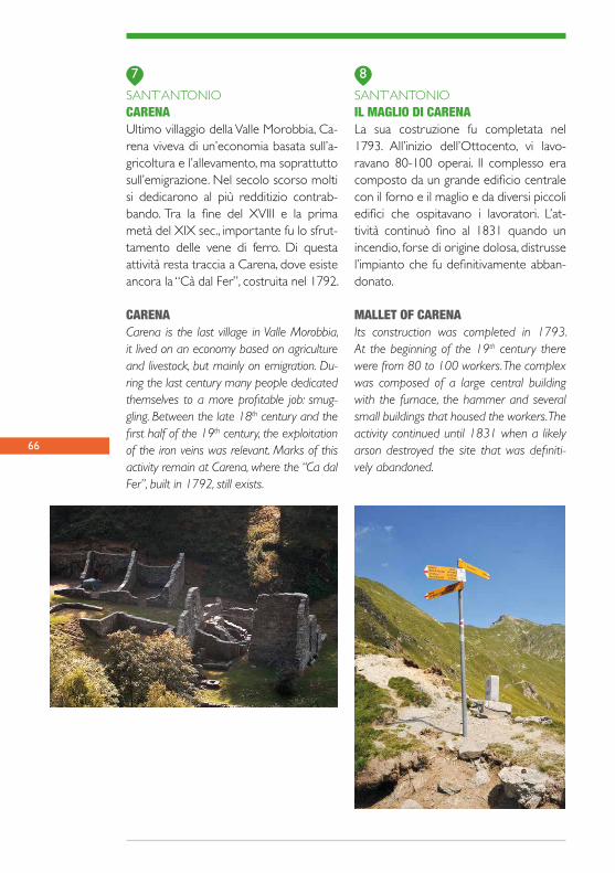
66
SANT’ANTONIOCARENAUltimo villaggio della Valle Morobbia, Ca-rena viveva di un’economia basata sull’a-gricoltura e l’allevamento, ma soprattutto sull’emigrazione. Nel secolo scorso molti si dedicarono al più redditizio contrab-bando. Tra la fine del XVIII e la prima metà del XIX sec., importante fu lo sfrut-tamento delle vene di ferro. Di questa attività resta traccia a Carena, dove esiste ancora la “Cà dal Fer”, costruita nel 1792.
CARENACarena is the last village in Valle Morobbia, it lived on an economy based on agriculture and livestock, but mainly on emigration. Du-ring the last century many people dedicated themselves to a more profitable job: smug-gling. Between the late 18th century and the first half of the 19th century, the exploitation of the iron veins was relevant. Marks of this activity remain at Carena, where the “Ca dal Fer”, built in 1792, still exists.
SANT’ANTONIOIL MAGLIO DI CARENALa sua costruzione fu completata nel 1793. All’inizio dell’Ottocento, vi lavo-ravano 80-100 operai. Il complesso era composto da un grande edificio centrale con il forno e il maglio e da diversi piccoli edifici che ospitavano i lavoratori. L’at-tività continuò fino al 1831 quando un incendio, forse di origine dolosa, distrusse l’impianto che fu definitivamente abban-donato.
MALLET OF CARENAIts construction was completed in 1793. At the beginning of the 19th century there were from 80 to 100 workers. The complex was composed of a large central building with the furnace, the hammer and several small buildings that housed the workers. The activity continued until 1831 when a likely arson destroyed the site that was definiti-vely abandoned.
87
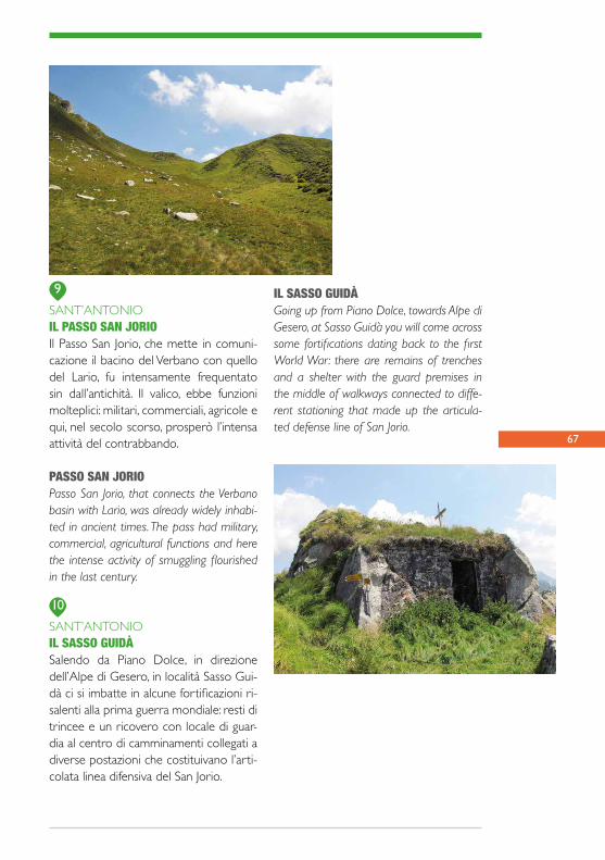
67
SANT’ANTONIOIL PASSO SAN JORIOIl Passo San Jorio, che mette in comuni-cazione il bacino del Verbano con quello del Lario, fu intensamente frequentato sin dall’antichità. Il valico, ebbe funzioni molteplici: militari, commerciali, agricole e qui, nel secolo scorso, prosperò l’intensa attività del contrabbando.
PASSO SAN JORIOPasso San Jorio, that connects the Verbano basin with Lario, was already widely inhabi-ted in ancient times. The pass had military, commercial, agricultural functions and here the intense activity of smuggling flourished in the last century.
SANT’ANTONIOIL SASSO GUIDÀ Salendo da Piano Dolce, in direzione dell’Alpe di Gesero, in località Sasso Gui-dà ci si imbatte in alcune fortificazioni ri-salenti alla prima guerra mondiale: resti di trincee e un ricovero con locale di guar-dia al centro di camminamenti collegati a diverse postazioni che costituivano l’arti-colata linea difensiva del San Jorio.
9
10
IL SASSO GUIDÀ Going up from Piano Dolce, towards Alpe di Gesero, at Sasso Guidà you will come across some fortifications dating back to the first World War: there are remains of trenches and a shelter with the guard premises in the middle of walkways connected to diffe-rent stationing that made up the articula-ted defense line of San Jorio.

68
DATA - DATE _ _ / _ _ / _ _
APPUNTI DI VIAGGIO - TRAVEL NOTES

69
I TUOI SCHIZZI - YOUR SKETCHES

MONTE BISBINO
5 43
2
1
4
32
1
12
6
Punti di interesse in territorio italiano - Point of interest in Italy
Punti di interesse nei tratti comuni - Common point of interest
Punti di interesse in territorio svizzero - Point of interest in Switzerland
data © OpenStreetMap Contributors, ODbL
SVIZZERA
ITALIA
SAGNO
CERNOBBIO
7171
CERNOBBIO - SAGNO - MONTE BISBINOMaggiori informazioni More informationsul sito www.viaregina.eu sezione Geoportale > Transguardiuna soluzione emotiva e coinvolgente che accompagna l’utente in un tour virtuale
sul sito www.viaregina.eu sezione Geoportale > Transguardian emotional and engaging solution, which guides you on a virtual tour

72
L’itinerario sul versante italiano si sviluppa lungo un tracciato che collega il lago con la montagna ed offre numerosi spunti di interesse e alcuni incan-tevoli scorci panoramici sul bacino di Como, sulla Valbreggia e verso la pianura. Nella prima parte il percorso attraversa il centro storico di Cernob-bio, nei pressi della riva del lago, e salendo con-duce ai nuclei storici disposti lungo le pendici del monte. In seguito il tracciato si inerpica immer-gendosi nella natura e raggiunge il nucleo mon-tano di Piazzola e infine la Croce dell’Uomo e la vetta del Bisbino dai quali si godono ampie vedute.Sul versante svizzero, partendo da Sagno si segue una mulattiera che si collega al tracciato prove-niente da Cernobbio alla località “Crusètt” da dove un sentiero di crinale porta al Bisbino.
The itinerary in the italian side runs along a route connecting the lake to the mountains and offers many points of interest and wonderful panoramic views of Lake Como, Valbreggia and the plain. In the first part the road passes throu-gh the historical center of Cernobbio, near the lake shore, and going up it leads to the historical hamlets on the mountain slopes, then it winds up plunging into nature and reaches the mountain hamlet of Piazzola and at the end The “Croce dell’Uomo” (Cross of the man) and the peak of Bisbino from where you can enjoy a beautiful view. Along the Swiss side, from Sagno follow the mule track that connects with the track coming from Cernobbio at “Crusètt” locality, where a ridge path leads to Bisbino.
CERNOBBIOVILLA BERNASCONILa villa, pregevole architettura liberty, fu costruita all’inizio del XX secolo su progetto dell’architetto Alfredo Campa-nini per Davide Bernasconi, proprietario dell’omonima tessitura, e presenta sulle facciate singolari decorazioni con bachi, farfalle e foglie di gelso ispirate alla pro-duzione della seta.
VILLA BERNASCONIThe villa is a beautiful example of Art Nouveau architecture. Designed by archi-tect Alfredo Campanini, it was built at the beginning of the 20th century for Davide Bernasconi, owner of the silk factory with the same name. The exterior façades are enriched with decorations like silkworms, butterflies and mulberry leaves related to silk production.
CERNOBBIOCHIESA DI SAN VINCENZOLa chiesa è l’antica parrocchiale di Cer-nobbio, ricostruita fra il 1757 ed il 1775. L’interno è a una navata con due cap-pelle laterali con altari settecenteschi e nel presbiterio si conserva una statua lignea della Madonna col Bambino del XVII secolo.
1
2
PARTENDO DALL’ITALIASTARTING FROM ITALY
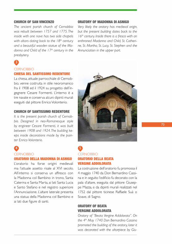
73
CHURCH OF SAN VINCENZOThe ancient parish church of Cernobbio was rebuilt between 1757 and 1775. The inside with one nave has two side chapels with altars dating back to the 18th century and a beautiful wooden statue of the Ma-donna and Child of the 17th century in the presbytery.
CERNOBBIOCHIESA DEL SANTISSIMO REDENTORELa chiesa, attuale parrocchiale di Cernob-bio, venne costruita in stile neoromanico fra il 1908 ed il 1924 su progetto dell’in-gegnere Cesare Formenti. L’interno è a tre navate e conserva alcuni dipinti murali eseguiti dal pittore Enrico Volonterio.
CHURCH OF SANTISSIMO REDENTOREIt is the present parish church of Cernob-bio. Designed in neo-Romanesque style by engineer Cesare Formenti, it was built between 1908 and 1924. The building ke-eps inside decorations made by the pain-ter Enrico Volonterio.
CERNOBBIOORATORIO DELLA MADONNA DI ASNIGOL’oratorio ha forse origini medievali ma l’attuale assetto risale al XVI secolo. All’interno si conserva un affresco con la Madonna col Bambino in trono, Santa Caterina e Santa Marta, ai lati Santa Lucia e Santo Stefano e nel registro superiore l’Annunciazione. L’altare laterale presenta una statua della Madonna col Bambino e ai lati due figure di santi.
ORATORY OF MADONNA DI ASNIGOVery likely the oratory has medieval origin, but the present building dates back to the 16th century. Inside there is a fresco with an enthroned Madonna and Child, St. Catheri-ne, St. Martha, St. Lucy, St. Stephen and the Annunciation in the upper part.
CERNOBBIOORATORIO DELLA BEATAVERGINE ADDOLORATALa costruzione dell’oratorio fu promossa il 4 maggio 1740 da Don Bernardino Cassi-na e in seguito l’edificio fu decorato con la pala d’altare, eseguita dal pittore Giusep-pe Mazza, e da dipinti murali realizzati nel 1752 dal pittore ticinese Raffaele Suà o Soave, di Sagno.
ORATORY OF BEATAVERGINE ADDOLORATAOratory of “Beata Vergine Addolorata”. On the 4th May 1740 Don Bernardino Cassina promoted the building of the oratory, later it was decorated with the altarpiece by Giu-
3
4 5

seppe Mazza and in 1752 the walls were painted by Raffaele Suà an artist coming from Canton Ticino (CH).
CERNOBBIOEX CASERMADELLA FINANZA DI PIAZZOLAL’edificio era un elemento del sistema di controllo realizzato per contrastare il fe-nomeno del contrabbando. La scelta di realizzare una caserma a Piazzola risale al 1901 e i lavori di costruzione furono eseguiti fra il 1904 e il 1905 dall’impresa Dotti Giovanni.
FORMER BARRACKS OF THE CUSTOMS POLICE OF PIAZZOLA The building was part of a system of con-trol created to hinder smuggling and it was finished in 1905 by the firm Dotti Giovanni.
74 6
1
PARTENDO DALLA SVIZZERASTARTING FROM SWITZERLAND
SAGNOCHIESA DI SAN MICHELE ARCANGELOChiesa di origine romanica, dedicata al patrono dei pellegrini, documentata dal 1373. Dell’edificio romanico resta sola-mente il campanile. La chiesa attuale è stata edificata alla fine del XVIII secolo su disegni di Simone Cantoni di Muggio. All’interno, navata decorata con dipinti tardo neoclassici.
CHURCH OF SAN MICHELE ARCANGELOThe church is dedicated to the patron saint of pilgrims. Only the belfry remains of the Romanesque building. The present church was built at the end of the 18th century, and was designed by Simone Cantoni from Muggio. Inside, along the nave, there are paintings of the late neo-classic period.
SAGNOUno dei villaggi più meridionali della Sviz-zera. La località era abitata già in epoca preromana e romana, come testimoniano alcuni ritrovamenti archeologici. In età me-dievale vi era una fortezza posta a control-lo dei transiti verso la Valle d’Intelvi.
It is one of the most southern villages in Switzerland. Some archeological finds testi-fy that the place was inhabited in the Ro-man period. During the Middle Ages there
2

75
SAGNOCRUSÈTTQui sorgono tre croci in legno, nei pressi del confine di stato. Questa località, il 2 lu-glio del 1843, fu teatro di episodi noti come “I fatti del Bisbino”. Di ritorno dalla proces-sione al Santuario scoppiò un alterco tra opposte fazioni politiche che portò all’ucci-sione di un carabiniere di Chiasso. Le suc-cessive rappresaglie portarono alla morte del parroco e del panettiere di Bruzella.
CRUSÈTT (THE SMALL CROSSES)Near the state border there are three small crosses. Here in 1843 there was a riot among the different political factions that ended with the killing of a “Carabinie-re”. The following reprisals lead to the dead of the parish priest and the baker.
SAGNOALPE CAVAZZOIn una carta storica del 1762 è indicata la “Strada della Cavazza”. Nel 1558 questa viene espressamente citata. I “comunisti” di Morbio Superiore ne impediscono l’u-so, escludendo dal veto gli abitanti di Sa-gno che salgono alla Madonna del Monte Bisbino per le rogazioni.
ALPE CAVAZZOIn a historical map of 1762 is named as “Strada della Cavazza”. For a long time only the inhabitants of Sagno were allowed to take this road to Mount Bisbino.
was a fortress that watched the transits towards Valle d’Intelvi.
CERNOBBIOLINEA CADORNAData la sua posizione, durante la prima guerra mondiale venne realizzato sul Monte Bisbino un sistema difensivo noto come Linea Cadorna: un complesso di fortificazioni che si estendono per oltre 2 chilometri con diverse trincee, opere in caverna e appostamenti d’artiglieria realizzato nel 1916.
LINEA CADORNADuring the first World War, in 1916, a de-fensive system known as Linea Cadorna was built on Mount Bisbino. It is formed by fortifications with trenches and tunnels co-vering more than two kilometers.
CERNOBBIO SANTUARIO DELLA BEATA VERGINE Il semplice interno accoglie una statua in marmo bianco attribuita alla scuola di Leonardo da Vinci e moltissimi ex-voto donati da soldati sopravvissuti alla se-conda guerra mondiale.
SANCTUARY OF THE HOLY VIRGIN The very simple inside keeps a statue in white marble attributed to the school of Leonardo da Vinci and many ex-voto given after the second World War by the soldiers who survived.
PUNTO DI INCONTROMEETING POINTS
TRAGITTO COMUNECOMMON ITINERARY
1
2
3
4

76
DATA - DATE _ _ / _ _ / _ _
APPUNTI DI VIAGGIO - TRAVEL NOTES

77
I TUOI SCHIZZI - YOUR SKETCHES
Pubblicazione coordinata daComune di Cernobbio
testi diMassimo ColomboGiorgio CostanzoAmbra GaranciniEnrica GuanellaMarco Leoni
traduzioniDonatella Bonini
foto diMassimo ColomboGiorgio Costanzo, archivio Associazione IubilantesMarco LeoniLorenzo MussiArchivio Mu.Vi.S
dati cartografici di base delle cartine© OpenStreetMap contributors
progetto graficoimpaginazioneAlice Fattorini stampaTipografia Banfi - Como
I edizione
Tutti i diritti riservati.Nessuna parte di questa pubblicazione può essere riprodotta,interamente o in parte, memorizzata o inserita in un sistemadi ricerca delle informazioni o trasmessa in qualsiasi formae con qualsiasi mezzo (elettronico o meccanico, in fotocopia o altro),senza il previo consenso scritto.
PARTNER DI PROGETTO
Politecnico di MilanoPolo Territoriale di Como (PoliMI)
Università degli Studi di Pavia
Consorzio Frazioni Corti Acero
Comunità Montana Vallidel Lario e del Ceresio
Comunità MontanaLario Intelvese
Comune di Cernobbio
Scuola universitaria professionaledella Svizzera italiana
Fondazione Politecnico di Milano
Associazione Iubilantes
Finito di stampare nel mese di settembre 2015
Pubblicazione cofinanziata con risorse PO Italia - Svizzera 2007 - 2013 Fondo Europeo di Sviluppo Regionale
Inco
lla l’
alet
ta e
avr
ai u
na
tasc
a -
Glu
e th
e fla
p, y
ou’ll
get
an
insid
e po
cket

I C
AM
MIN
I D
EL
LA
RE
GIN
A