
GAIL: Geometry-aware Automatic Image Localization
10
GAIL: Geometry-aware Automatic Image Localization Luca Benedetti, Massimiliano Corsini, Matteo Dellepiane, Paolo Cignoni, and Roberto Scopigno Visual Computing Lab, ISTI-CNR – Pisa, Italy. E-mail: {benedetti,corsini,dellepiane,cignoni,scopigno}@isti.cnr.it Keywords: Image-based Localization, 2D/3D Registration Abstract: The access and integration of the massive amount of information, that can be provided by the web, can be of great help in a number of fields, including tourism and advertising of artistic sites. A “virtual visit” of a place can be a valuable experience before, during and after the experience on-site. For this reason, the contribution from the public could be merged to provide a realistic and immersive visit of known places. We propose an automatic image localization system, which is able to recognize the site that has been framed, and calibrate it on a pre-existing 3D representation. The system is characterized by very high accuracy and it is able to validate, in a completely unsupervised manner, the result of the localization. Given an unlocalized image, the system selects a relevant set of pre-localized images, performs a Structure from Motion partial reconstruction of this set and then obtain an accurate camera calibration of the image with respect to the model by minimizing distances between projections on the model surface of corresponding image features. The accuracy reached is enough to seamlessly view the input image correctly super-imposed in the 3D scene. 1 Introduction Automatic image localization is an active research field in Computer Vision and Computer Graphics, with many important applications. This has become especially important given the potentials of all the im- ages coming from the web community. Traditional lo- calization solutions, e.g. Global Positioning System (GPS), may present issues in certain urban areas or indoor environments, or may not be accurate enough. Moreover, both the position and the orientation of the camera could be a valuable source of data. Alterna- tives, like inertial drift-free systems, are too expen- sive to be applied on a large scale. In this case, the only class of solutions realistically feasible today is the use of image-based localization systems. Many aspects of the automatic image localization problem have been independently tackled, and tremendous ad- vances have been obtained in recent years. Here, we are interested in the automatic user local- ization through the use of digital consumer cameras or smartphones to support information services for tourists. In particular, we cope with a particular im- age localization scenario, that, to our knowledge, has never been faced in literature: exploiting pre-existing high quality 3D models of the photographs’ environ- ment for performing an offline, fully automatic, pre- cise, unsupervised image localization. We aim to ob- tain such an accuracy to allow a seamless view im- mersion into the 3D scene by projecting the photos on the 3D models. High accuracy allows to re-visualize the picture of the tourist in PhotoCloud (Brivio et al., 2012) that is a CG application which shares some sim- ilarities with Photo Tourism (Snavely et al., 2006). This is one of the main goal of an ongoing project related to tourism and valorization of artistic sites. The proposed system effectively merges solutions from image retrieval, Structure from Motion and 2D/3D registration. In this context, our contribution is twofold: an image-based localization algorithm ca- pable to obtain very high accuracy by exploiting pre- existing high quality 3D models of the locations of in- terest, and an unsupervised validation algorithm that guarantees to present only correct results to the user. The developed system works by exploiting a dataset of pre-aligned digital photographs on 3D models of the locations of interest. 2 Related work Image localization is a vast field. Here, we present a brief overview of some of the most relevant publi- cations. Morris and Smelyanskiy (Morris and Smelyan- skiy, 2001) faced the problem of single image calibra-
Transcript of GAIL: Geometry-aware Automatic Image Localization

GAIL: Geometry-aware Automatic Image Localization
Luca Benedetti, Massimiliano Corsini, Matteo Dellepiane, Paolo Cignoni, and Roberto ScopignoVisual Computing Lab, ISTI-CNR – Pisa, Italy.
E-mail: {benedetti,corsini,dellepiane,cignoni,scopigno}@isti.cnr.it
Keywords: Image-based Localization, 2D/3D Registration
Abstract: The access and integration of the massive amount of information, that can be provided by the web, can be ofgreat help in a number of fields, including tourism and advertising of artistic sites. A “virtual visit” of a placecan be a valuable experience before, during and after the experience on-site. For this reason, the contributionfrom the public could be merged to provide a realistic and immersive visit of known places. We propose anautomatic image localization system, which is able to recognize the site that has been framed, and calibrateit on a pre-existing 3D representation. The system is characterized by very high accuracy and it is able tovalidate, in a completely unsupervised manner, the result of the localization. Given an unlocalized image, thesystem selects a relevant set of pre-localized images, performs a Structure from Motion partial reconstructionof this set and then obtain an accurate camera calibration of the image with respect to the model by minimizingdistances between projections on the model surface of corresponding image features. The accuracy reached isenough to seamlessly view the input image correctly super-imposed in the 3D scene.
1 Introduction
Automatic image localization is an active researchfield in Computer Vision and Computer Graphics,with many important applications. This has becomeespecially important given the potentials of all the im-ages coming from the web community. Traditional lo-calization solutions, e.g. Global Positioning System(GPS), may present issues in certain urban areas orindoor environments, or may not be accurate enough.Moreover, both the position and the orientation of thecamera could be a valuable source of data. Alterna-tives, like inertial drift-free systems, are too expen-sive to be applied on a large scale. In this case, theonly class of solutions realistically feasible today isthe use of image-based localization systems. Manyaspects of the automatic image localization problemhave been independently tackled, and tremendous ad-vances have been obtained in recent years.Here, we are interested in the automatic user local-ization through the use of digital consumer camerasor smartphones to support information services fortourists. In particular, we cope with a particular im-age localization scenario, that, to our knowledge, hasnever been faced in literature: exploiting pre-existinghigh quality 3D models of the photographs’ environ-ment for performing an offline, fully automatic, pre-cise, unsupervised image localization. We aim to ob-
tain such an accuracy to allow a seamless view im-mersion into the 3D scene by projecting the photos onthe 3D models. High accuracy allows to re-visualizethe picture of the tourist in PhotoCloud (Brivio et al.,2012) that is a CG application which shares some sim-ilarities with Photo Tourism (Snavely et al., 2006).This is one of the main goal of an ongoing projectrelated to tourism and valorization of artistic sites.
The proposed system effectively merges solutionsfrom image retrieval, Structure from Motion and2D/3D registration. In this context, our contributionis twofold: an image-based localization algorithm ca-pable to obtain very high accuracy by exploiting pre-existing high quality 3D models of the locations of in-terest, and an unsupervised validation algorithm thatguarantees to present only correct results to the user.The developed system works by exploiting a datasetof pre-aligned digital photographs on 3D models ofthe locations of interest.
2 Related work
Image localization is a vast field. Here, we presenta brief overview of some of the most relevant publi-cations.
Morris and Smelyanskiy (Morris and Smelyan-skiy, 2001) faced the problem of single image calibra-

tion over a 3D surface and the simultaneous surfacerefinement based on additional information given bythe image. The algorithm is based on the extractionof image salient points (using Harris detector (Har-ris and Stephens, 1988)) and employs minimizationof an objective function via gradient calculation. Theapproach works relatively well only when there is agood initial estimate of the surface, moreover it is notscalable.
Shao et al. (Shao et al., 2003) treated the prob-lem of database-based image recognition, by compar-ing them to a reference image through the use of lo-cal salient features that are described independentlyof possible affine transformations between them.
Wang et al. (Wang et al., 2004) proposed a so-lution for the Simultaneous Localization And Track-ing (SLAM) robotic problem (Smith and Cheeseman,1986). A database of salient points, extracted fromthe robot camera, is used for the localization. SLAMapproaches suffer from the “Kidnap problem”, i.e. theinability to continue the localization and mapping be-tween non-contiguous locations.
Cipolla et al. (Cipolla et al., 2004) tried tosolve this by applying wide baseline matching al-gorithm techniques between a digital photo and ageo-referenced database. The main limitation of thisapproach comes from the manual construction ofthe database correspondences between the map andthe photos. Robertson and Cipolla (Robertson andCipolla, 2004) proposed an improvement of it by ex-ploiting the perspective lines relative to the verticaledges of buildings.
Zhang and Kosecka (Zhang and Kosecka, 2006)built a prototype for urban localization of images thatrelies on a photographic database augmented withGPS information. The system extracts one or morereference images and from these localized the inputimage.
Paletta et al. (Paletta et al., 2006) defined a specificsystem devoted to the improvement in the descrip-tion of the images’ salient points, called “informative-SIFT”.
Gordon and Lowe (Gordon and Lowe, 2006) pro-posed the first work which exploited Structure-from-Motion (SFM) for precise localization of the input im-age. This approach provided interesting ideas in laterworks (Irschara et al., 2009; Li et al., 2010; Sattleret al., 2011).
Schindler et al. (Schindler et al., 2007) facedthe problem of localization in very large datasets ofstreets’ photographs using a tree data structure thatindexes the salient features for scalability.
Zhu et al. (Zhu et al., 2008) built another systemfor large-scale global localization, with very high ac-
curacy thanks to the use of 4 cameras, arranged as twostereo pairs.
Xiao et al. (Xiao et al., 2008) proposed a methodfor the recognition and localization of generic ob-jects from uncalibrated images. The system includesan interesting algorithm for simultaneous localiza-tion of objects and camera positions, which combinessegmentation techniques, example models and votingtechniques. The main purpose of the system is ob-ject recognition using structural representation in 3Dspace.
Irschara et al. (Irschara et al., 2009) proposed alocalization system that effectively exploited image-based 3D reconstruction. After the reconstruction,each 3D point is associated to a compressed descrip-tion of the features of the images incidents therein.Such descriptions are indexed using a tree-based vo-cabularies for efficient searching.
Li et al. (Li et al., 2010) proposed another feature-based approach based on a prioritization scheme. Thepriority of a point is related to the number of camerasfrom the reconstruction it is visible in. The use of areduced set of points of highest priority has severaladvantages w.r.t. to using all 3D points. This method,in terms of the number of images that can be regis-tered, outperforms the algorithm by Irschara et al.
Recently, Sattler et al. (Sattler et al., 2011) pro-posed a direct 2D-to-3D matching framework. Byassociating 3D points to visual words, they quicklyidentify possible correspondences for 2D featureswhich are then verified in a linear search. The final2D-to-3D correspondences are then used to localizethe image using N-point pose estimation.
Our work shares some similarities with the meth-ods of Irschara (Irschara et al., 2009) and Sattler (Sat-tler et al., 2011). The novelty stands in the use ofa more advanced image retrieval algorithm, the ex-ploitation of 3D geometric information that is not de-pendant on the photographic dataset, and the valida-tion through an unsupervised validation algorithm.
3 Geometry-aware Automatic ImageLocalization
Our system deals with two specific requirements:the localization hast to be automatic and accurateenough to allow correct superimposition of the inputimage on the 3D model for presentation purposes tothe tourists. There are no strict time constraints.
Our solution combines a state-of-the-art image re-trieval system, an SFM algorithm and solutions com-ing from 2D/3D registration to recast the problem ina large-scale 2D/3D calibration problem.
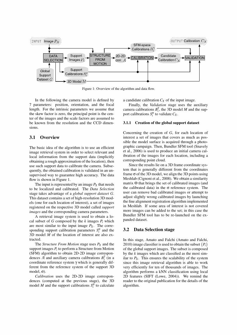
Figure 1: Overview of the algorithm and data flow.
In the following the camera model is defined by7 parameters: position, orientation, and the focallength. For the intrinsic parameters we assume thatthe skew factor is zero, the principal point is the cen-ter of the images and the scale factors are assumed tobe known from the resolution and the CCD dimen-sions.
3.1 Overview
The basic idea of the algorithm is to use an efficientimage retrieval system in order to select relevant andlocal information from the support data (implicitlyobtaining a rough approximation of the location), thenuse such support data to calibrate the camera. Subse-quently, the obtained calibration is validated in an un-supervised way to guarantee high accuracy. The dataflow is shown in Figure 1.
The input is represented by an image PX that needsto be localized and calibrated. The Data Selectionstage takes advantage of a global support dataset G.This dataset contains a set of high-resolution 3D mod-els (one for each location of interest), a set of imagesregistered on the respective 3D model called supportimages and the corresponding camera parameters.
A retrieval image system is used to obtain a lo-cal subset of G composed by the k images Pi whichare most similar to the input image PX . The corre-sponding support calibration parameters Sσ
i and the3D model M of the location of interest are also ex-tracted.
The Structure From Motion stage uses PX and thesupport images Pi to perform a Structure from Motion(SFM) algorithm to obtain 2D-2D image correspon-dences A and auxiliary camera calibrations Bγ
i (in acoordinate reference system γ which is generally dif-ferent from the reference system of the support 3Dmodel, σ).
Calibration uses the 2D-2D image correspon-dences (computed at the previous stage), the 3Dmodel M and the support calibrations Sσ
i to calculate
a candidate calibration CX of the input image.Finally, the Validation stage uses the auxiliary
camera calibrations Bγi , the 3D model M and the sup-
port calibrations Sσi to validate CX .
3.1.1 Creation of the global support dataset
Concerning the creation of G, for each location ofinterest a set of images that covers as much as pos-sible the model surface is acquired through a photo-graphic campaign. Then, Bundler SFM tool (Snavelyet al., 2006) is used to produce an initial camera cal-ibration of the images for each location, including acorresponding point cloud.
Since the results lie on a 3D frame coordinate sys-tem that is generally different from the coordinatesframe σ of the 3D model, we align the 3D points usingMeshlab (Cignoni et al., 2008). We obtain a similaritymatrix Θ that brings the set of calibrated images (andthe calibrated data) in the σ reference system. Theuser can remove bad calibrated images or attempt toadjust slightly wrong calibrated images by launchingthe fine alignment registration algorithm implementedin Meshlab. If some area of interest is not coveredmore images can be added to the set; in this case theBundler SFM tool has to be re-launched on the ex-panded dataset.
3.2 Data Selection stage
In this stage, Amato and Falchi (Amato and Falchi,2010) image classifier is used to obtain the subset {Pi}of the global support images. The subset is composedby the k images which are classified as the most sim-ilar to PX . This ensures the scalability of the systemsince this image retrieval algorithm is able to workvery efficiently for ten of thousands of images. Thealgorithm performs a kNN classification using local2D features (SIFT (Lowe, 2004)). We remind thereader to the original publication for the details of thealgorithm.
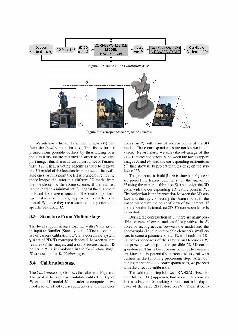
Figure 2: Scheme of the Calibration stage.
Figure 3: Correspondence projection scheme.
We retrieve a list of 15 similar images (Pi) thatform the local support images. This list is furtherpruned from possible outliers by thresholding overthe similarity metric returned in order to have sup-port images that shares at least a partial set of featuresw.r.t. PX . Then, a voting scheme is used to retrievethe 3D model of the location from the set of the avail-able ones. At this point the list is pruned by removingthose images that refer to a different 3D model fromthe one chosen by the voting scheme. If the final listis smaller than a minimal set (3 images) the alignmentfails and the image is rejected. The local support im-ages just represent a rough approximation of the loca-tion of PX , since they are associated to a portion of aspecific 3D model M.
3.3 Structure From Motion stage
The local support images together with PX are givenin input to Bundler (Snavely et al., 2006) to obtain aset of camera calibrations Bγ
i , in a coordinate systemγ, a set of 2D-2D correspondences A between salientfeatures of the images, and a set of reconstructed 3Dpoints in γ. A is employed in the Calibration stage,Bγ
i are used in the Validation stage.
3.4 Calibration stage
The Calibration stage follows the scheme in Figure 2.The goal is to obtain a candidate calibration CX ofPX on the 3D model M. In order to compute it, weneed a set of 2D-3D correspondences B that matches
points on PX with a set of surface points of the 3Dmodel. These correspondences are not known in ad-vance. Nevertheless, we can take advantage of the2D-2D correspondences A between the local supportimages Pi and PX , and the corresponding calibrationsSσ
i , that allow us to project features of Pi on the sur-face of M.
The procedure to build β∈B is shown in Figure 3:we project the feature point in Pi on the surface ofM using the camera calibration Sσ
i and assign the 3Dpoint with the corresponding 2D feature point in PX .The projection is the intersection between the 3D sur-face and the ray connecting the feature point in theimage plane with the point of view of the camera. Ifno intersection is found, no 2D-3D correspondence isgenerated.
During the construction of B , there are many pos-sible sources of error, such as false positives in A ,holes or incongruences between the model and thephotographs (i.e. due to movable elements), small er-rors in camera parameters, etc. Even if multiple 2D-2D correspondences of the same visual feature in PXare present, we keep all the possible 2D-3D corre-spondences. This is because our policy is to keep ev-erything that is potentially correct and to deal withoutliers in the following processing step. After ob-taining the set of 2D-3D correspondences, we proceedwith the effective calibration.
The calibration step follows a RANSAC (Fischlerand Bolles, 1981) approach, that in each iteration se-lect a subset of B , making sure to not take dupli-cates of the same 2D feature on PX . Then, it com-
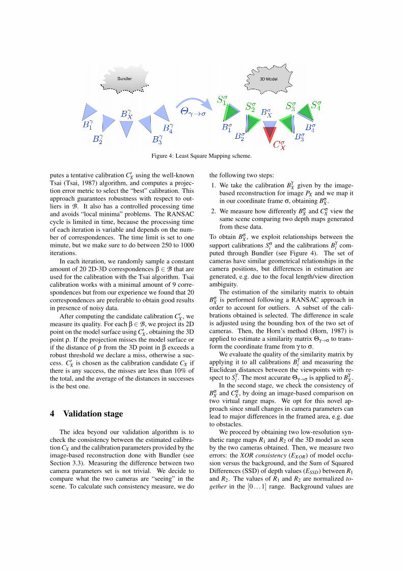
Figure 4: Least Square Mapping scheme.
putes a tentative calibration C′X using the well-knownTsai (Tsai, 1987) algorithm, and computes a projec-tion error metric to select the “best” calibration. Thisapproach guarantees robustness with respect to out-liers in B . It also has a controlled processing timeand avoids “local minima” problems. The RANSACcycle is limited in time, because the processing timeof each iteration is variable and depends on the num-ber of correspondences. The time limit is set to oneminute, but we make sure to do between 250 to 1000iterations.
In each iteration, we randomly sample a constantamount of 20 2D-3D correspondences β ∈ B that areused for the calibration with the Tsai algorithm. Tsaicalibration works with a minimal amount of 9 corre-spondences but from our experience we found that 20correspondences are preferable to obtain good resultsin presence of noisy data.
After computing the candidate calibration C′X , wemeasure its quality. For each β ∈ B , we project its 2Dpoint on the model surface using C′X , obtaining the 3Dpoint ρ. If the projection misses the model surface orif the distance of ρ from the 3D point in β exceeds arobust threshold we declare a miss, otherwise a suc-cess. C′X is chosen as the calibration candidate CX ifthere is any success, the misses are less than 10% ofthe total, and the average of the distances in successesis the best one.
4 Validation stage
The idea beyond our validation algorithm is tocheck the consistency between the estimated calibra-tion CX and the calibration parameters provided by theimage-based reconstruction done with Bundler (seeSection 3.3). Measuring the difference between twocamera parameters set is not trivial. We decide tocompare what the two cameras are “seeing” in thescene. To calculate such consistency measure, we do
the following two steps:1. We take the calibration Bγ
X given by the image-based reconstruction for image PX and we map itin our coordinate frame σ, obtaining Bσ
X .
2. We measure how differently BσX and Cσ
X view thesame scene comparing two depth maps generatedfrom these data.
To obtain BσX , we exploit relationships between the
support calibrations Sσi and the calibrations Bγ
i com-puted through Bundler (see Figure 4). The set ofcameras have similar geometrical relationships in thecamera positions, but differences in estimation aregenerated, e.g. due to the focal length/view directionambiguity.
The estimation of the similarity matrix to obtainBσ
X is performed following a RANSAC approach inorder to account for outliers. A subset of the cali-brations obtained is selected. The difference in scaleis adjusted using the bounding box of the two set ofcameras. Then, the Horn’s method (Horn, 1987) isapplied to estimate a similarity matrix Θγ→σ to trans-form the coordinate frame from γ to σ.
We evaluate the quality of the similarity matrix byapplying it to all calibrations Bγ
i and measuring theEuclidean distances between the viewpoints with re-spect to Sγ
i . The most accurate Θγ→σ is applied to Bγ
X .In the second stage, we check the consistency of
BσX and Cσ
X , by doing an image-based comparison ontwo virtual range maps. We opt for this novel ap-proach since small changes in camera parameters canlead to major differences in the framed area, e.g. dueto obstacles.
We proceed by obtaining two low-resolution syn-thetic range maps R1 and R2 of the 3D model as seenby the two cameras obtained. Then, we measure twoerrors: the XOR consistency (EXOR) of model occlu-sion versus the background, and the Sum of SquaredDifferences (SSD) of depth values (ESSD) between R1and R2. The values of R1 and R2 are normalized to-gether in the [0 . . .1] range. Background values are

EXOR =∑0<x<w
0<y<hRX(R1,R2,x,y)
wh(1)
ESSD =∑0<x<w
0<y<hBH(R1,R2,x,y) · (R1(x,y)−R2(x,y))2
∑0<x<w0<y<h
BH(R1,R2,x,y)(2)
Almost CorrectEXOR = 0.0115ESSD = 0.0002
Bad XOR consistencyEXOR = 0.2416,ESSD = 0.0349
Bad SSD errorEXOR = 0.0339ESSD = 0.1720
Figure 5: (Left) Input image. (Center) Range map obtained from CσX . (Right) Range map obtained from Bσ
X .
set to ∞.
The XOR consistency (Eq. 1) is the percent of pix-els that in R1 are background and in R2 are not andvice-versa, where w and h are the size of the rangemaps and RX(R1,R2,x,y) assumes the value 1.0 whenthe condition (R1(x,y) = ∞)⊕ (R2(x,y) = ∞) is trueand 0.0 otherwise. It essentially accounts for differentpositions and directions of view.
The SSD error (Eq. 2) measures the dissimilarityin non-background areas, where BH(R1,R2,x,y) as-sumes the value 1.0 when both the pixels of R1(x,y)and R2(x,y) are foreground pixels and 0.0 otherwise.This measure accounts for errors in position and fo-cal length, that could lead to the different framing ofobjects which are near to the camera.
Examples of the consistency measures are shownin Figure 5. The second and the third rows show twocalibrations which are incorrect due to different rea-sons: in the first case, the XOR consistency results tobe very high; in the second case, the problem is indi-cated by the value of the SSD error.
5 Experimental results
In this section, we will describe and discuss theresults of the experimental evaluation of both the fullimage localization algorithm and the validation step.The global support dataset is composed by imagesand 3D models for 2 locations: “Piazza Cavalieri” inPisa (Italy) and “Piazza della Signoria” in Florence(Italy). The “Signoria” location is covered by 304calibrated images while the “Cavalieri” location by202 calibrated images. The corresponding 3D models(485k and 4083k faces respectively) have been ob-tained through ToF laser scanning, and prepared asexplained in Section 3.1.1.
5.1 Comparison with previous work
In order to assess the performance of our system, wecompared it with two recent state-of-the-art worksin image localization (Li et al., 2010; Sattler et al.,2011). Both these systems were tested using the same“Dubrovnik” dataset1, which is composed by 6844images. The authors test their systems by extracting
1Available at http://grail.cs.washington.edu/rome/dubrovnik/index.html
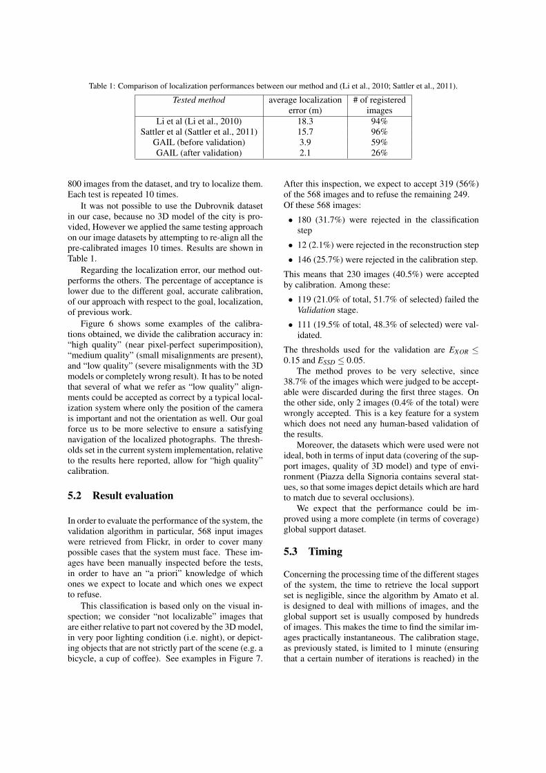
Table 1: Comparison of localization performances between our method and (Li et al., 2010; Sattler et al., 2011).
Tested method average localization # of registerederror (m) images
Li et al (Li et al., 2010) 18.3 94%Sattler et al (Sattler et al., 2011) 15.7 96%
GAIL (before validation) 3.9 59%GAIL (after validation) 2.1 26%
800 images from the dataset, and try to localize them.Each test is repeated 10 times.
It was not possible to use the Dubrovnik datasetin our case, because no 3D model of the city is pro-vided, However we applied the same testing approachon our image datasets by attempting to re-align all thepre-calibrated images 10 times. Results are shown inTable 1.
Regarding the localization error, our method out-performs the others. The percentage of acceptance islower due to the different goal, accurate calibration,of our approach with respect to the goal, localization,of previous work.
Figure 6 shows some examples of the calibra-tions obtained, we divide the calibration accuracy in:“high quality” (near pixel-perfect superimposition),“medium quality” (small misalignments are present),and “low quality” (severe misalignments with the 3Dmodels or completely wrong result). It has to be notedthat several of what we refer as “low quality” align-ments could be accepted as correct by a typical local-ization system where only the position of the camerais important and not the orientation as well. Our goalforce us to be more selective to ensure a satisfyingnavigation of the localized photographs. The thresh-olds set in the current system implementation, relativeto the results here reported, allow for “high quality”calibration.
5.2 Result evaluation
In order to evaluate the performance of the system, thevalidation algorithm in particular, 568 input imageswere retrieved from Flickr, in order to cover manypossible cases that the system must face. These im-ages have been manually inspected before the tests,in order to have an “a priori” knowledge of whichones we expect to locate and which ones we expectto refuse.
This classification is based only on the visual in-spection; we consider “not localizable” images thatare either relative to part not covered by the 3D model,in very poor lighting condition (i.e. night), or depict-ing objects that are not strictly part of the scene (e.g. abicycle, a cup of coffee). See examples in Figure 7.
After this inspection, we expect to accept 319 (56%)of the 568 images and to refuse the remaining 249.Of these 568 images:
• 180 (31.7%) were rejected in the classificationstep
• 12 (2.1%) were rejected in the reconstruction step
• 146 (25.7%) were rejected in the calibration step.
This means that 230 images (40.5%) were acceptedby calibration. Among these:
• 119 (21.0% of total, 51.7% of selected) failed theValidation stage.
• 111 (19.5% of total, 48.3% of selected) were val-idated.
The thresholds used for the validation are EXOR ≤0.15 and ESSD ≤ 0.05.
The method proves to be very selective, since38.7% of the images which were judged to be accept-able were discarded during the first three stages. Onthe other side, only 2 images (0.4% of the total) werewrongly accepted. This is a key feature for a systemwhich does not need any human-based validation ofthe results.
Moreover, the datasets which were used were notideal, both in terms of input data (covering of the sup-port images, quality of 3D model) and type of envi-ronment (Piazza della Signoria contains several stat-ues, so that some images depict details which are hardto match due to several occlusions).
We expect that the performance could be im-proved using a more complete (in terms of coverage)global support dataset.
5.3 Timing
Concerning the processing time of the different stagesof the system, the time to retrieve the local supportset is negligible, since the algorithm by Amato et al.is designed to deal with millions of images, and theglobal support set is usually composed by hundredsof images. This makes the time to find the similar im-ages practically instantaneous. The calibration stage,as previously stated, is limited to 1 minute (ensuringthat a certain number of iterations is reached) in the
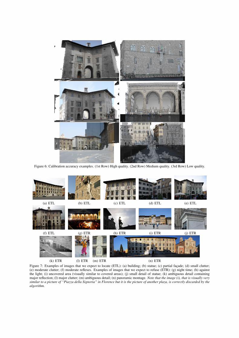
Figure 6: Calibration accuracy examples. (1st Row) High quality. (2nd Row) Medium quality. (3rd Row) Low quality.
(a) ETL (b) ETL (c) ETL (d) ETL (e) ETL
(f) ETL (g) ETR (h) ETR (i) ETR (j) ETR
(k) ETR (l) ETR (m) ETR (n) ETRFigure 7: Examples of images that we expect to locate (ETL): (a) building; (b) statue; (c) partial facade; (d) small clutter;(e) moderate clutter; (f) moderate reflexes. Examples of images that we expect to refuse (ETR): (g) night time; (h) againstthe light; (i) uncovered area (visually similar to covered areas); (j) small detail of statue; (k) ambiguous detail containingmajor reflection; (l) major clutter; (m) ambiguous detail; (n) panoramic montage. Note that the image (i), that is visually verysimilar to a picture of “Piazza della Signoria” in Florence but it is the picture of another plaza, is correctly discarded by thealgorithm.
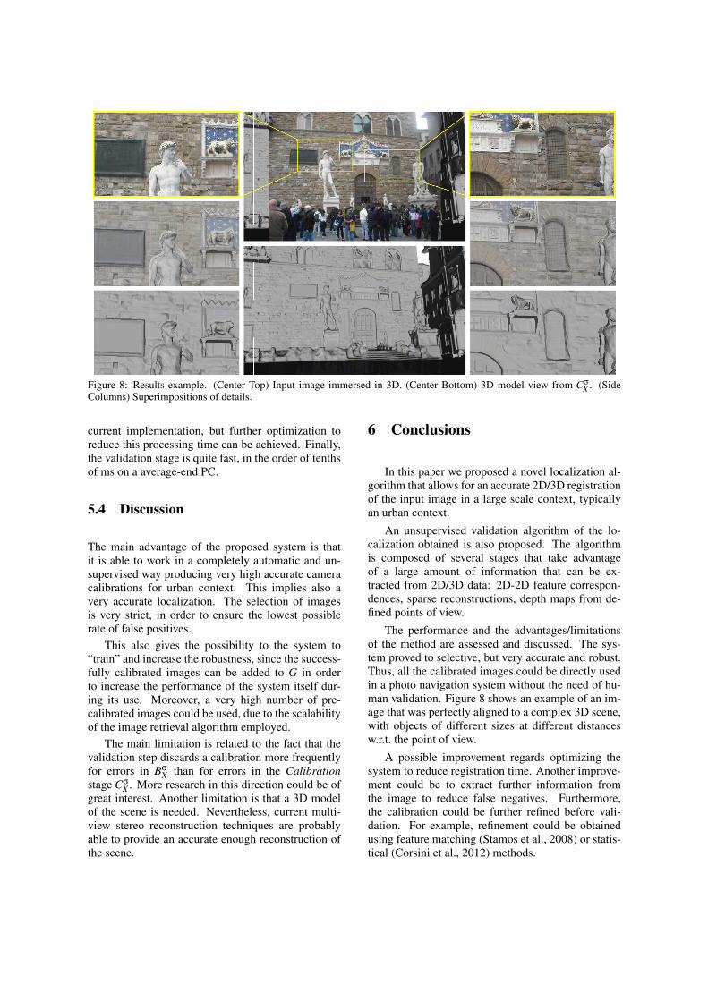
Figure 8: Results example. (Center Top) Input image immersed in 3D. (Center Bottom) 3D model view from CσX . (Side
Columns) Superimpositions of details.
current implementation, but further optimization toreduce this processing time can be achieved. Finally,the validation stage is quite fast, in the order of tenthsof ms on a average-end PC.
5.4 Discussion
The main advantage of the proposed system is thatit is able to work in a completely automatic and un-supervised way producing very high accurate cameracalibrations for urban context. This implies also avery accurate localization. The selection of imagesis very strict, in order to ensure the lowest possiblerate of false positives.
This also gives the possibility to the system to“train” and increase the robustness, since the success-fully calibrated images can be added to G in orderto increase the performance of the system itself dur-ing its use. Moreover, a very high number of pre-calibrated images could be used, due to the scalabilityof the image retrieval algorithm employed.
The main limitation is related to the fact that thevalidation step discards a calibration more frequentlyfor errors in Bσ
X than for errors in the Calibrationstage Cσ
X . More research in this direction could be ofgreat interest. Another limitation is that a 3D modelof the scene is needed. Nevertheless, current multi-view stereo reconstruction techniques are probablyable to provide an accurate enough reconstruction ofthe scene.
6 Conclusions
In this paper we proposed a novel localization al-gorithm that allows for an accurate 2D/3D registrationof the input image in a large scale context, typicallyan urban context.
An unsupervised validation algorithm of the lo-calization obtained is also proposed. The algorithmis composed of several stages that take advantageof a large amount of information that can be ex-tracted from 2D/3D data: 2D-2D feature correspon-dences, sparse reconstructions, depth maps from de-fined points of view.
The performance and the advantages/limitationsof the method are assessed and discussed. The sys-tem proved to selective, but very accurate and robust.Thus, all the calibrated images could be directly usedin a photo navigation system without the need of hu-man validation. Figure 8 shows an example of an im-age that was perfectly aligned to a complex 3D scene,with objects of different sizes at different distancesw.r.t. the point of view.
A possible improvement regards optimizing thesystem to reduce registration time. Another improve-ment could be to extract further information fromthe image to reduce false negatives. Furthermore,the calibration could be further refined before vali-dation. For example, refinement could be obtainedusing feature matching (Stamos et al., 2008) or statis-tical (Corsini et al., 2012) methods.
ACKNOWLEDGEMENTS
This paper has been supported by the Tuscany Re-gion (POR CREO FESR 2007-2013) in the frame-work of the VISITO-Tuscany project and by the EUFP7 INDIGO Innovative Training and Decision Sup-port for Emergency Operations project (grant no.242341). We would also thank Fabio Ganovelli foruseful suggestions and insights about this work.
REFERENCES
Amato, G. and Falchi, F. (2010). kNN based image clas-sification relying on local feature similarity. In Proc.SISAP’10, pages 101–108. ACM.
Brivio, P., Benedetti, L., Tarini, M., Ponchio, F., Cignoni, P.,and Scopigno, R. (2012). Photocloud: interactive re-mote exploration of large 2D-3D datasets. IEEE Com-puter Graphics and Applications, pages 1–20.
Cignoni, P., Callieri, M., Corsini, M., Dellepiane, M.,Ganovelli, F., and Ranzuglia, G. (2008). Meshlab:an open-source mesh processing tool. In Sixth Euro-graphics Italian Chapter Conference, pages 129–136.
Cipolla, R., Robertson, D., and Tordoff, B. (2004). Image-based localisation. In Proc. of 10th Int. Conf. on Vir-tual Systems and Multimedia, pages 22–29.
Corsini, M., Dellepiane, M., Ganovelli, F., Gherardi, R.,Fusiello, A., and Scopigno, R. (2012). Fully automaticregistration of image sets on approximate geometry.International Journal of Computer Vision, pages 1–21.
Fischler, M. and Bolles, R. (1981). Random sample con-sensus: a paradigm for model fitting with applicationsto image analysis and automated cartography. Com-munications of the ACM, 24(6):381–395.
Gordon, I. and Lowe, D. (2006). What and where: 3d objectrecognition with accurate pose. Toward category-levelobject recognition, pages 67–82.
Harris, C. and Stephens, M. (1988). A combined corner andedge detector. In Alvey vision conference, volume 15.Manchester, UK.
Horn, B. (1987). Closed-form solution of absolute orienta-tion using unit quaternions. JOSA A, (April).
Irschara, A., Zach, C., Frahm, J.-M., and Bischof, H.(2009). From structure-from-motion point clouds tofast location recognition. In CVPR, pages 2599–2606.
Li, Y., Snavely, N., and Huttenlocher, D. P. (2010). Loca-tion recognition using prioritized feature matching. InECCV, pages 791–804.
Lowe, D. (2004). Distinctive image features from scale-invariant keypoints. International journal of computervision, 60(2):91–110.
Morris, R. and Smelyanskiy, V. (2001). Matching imagesto models - camera calibration for 3-d surface recon-struction. Energy Minimization Methods, pages 105–117.
Paletta, L., Fritz, G., Seifert, C., Luley, P., and Almer, A.(2006). A mobile vision service for multimedia touristapplications in urban environments. 2006 IEEE Intel-ligent Transportation Systems Conference, pages 566–572.
Robertson, D. and Cipolla, R. (2004). An image-based sys-tem for urban navigation. In Proc. BMVC, volume 1,pages 260–272.
Sattler, T., Leibe, B., and Kobbelt, L. (2011). Fast image-based localization using direct 2d-to-3d matching. InIEEE International Conference on Computer Vision(ICCV), pages 667–674.
Schindler, G., Brown, M., and Szeliski, R. (2007).City-scale location recognition. In IEEE Confer-ence on Computer Vision and Pattern Recognition(CVPR2007), pages 1–7. IEEE Computer Society.
Shao, H., Svoboda, T., Tuytelaars, T., and Van Gool, L.(2003). HPAT indexing for fast object/scene recogni-tion based on local appearance. CIVR’03, pages 307–312.
Smith, R. and Cheeseman, P. (1986). On the representa-tion and estimation of spatial uncertainty. The inter-national journal of Robotics Research, 5(4):56.
Snavely, N., Seitz, S. M., and Szeliski, R. (2006). Phototourism: exploring photo collections in 3d. In SIG-GRAPH ’06, pages 835–846.
Stamos, I., Liu, L., Chen, C., Wolberg, G., Yu, G., andZokai, S. (2008). Integrating automated range regis-tration with multiview geometry for the photorealisticmodeling of large-scale scenes. Int. J. Comput. Vision,78:237–260.
Tsai, R. (1987). A versatile camera calibration techniquefor high-accuracy 3d machine vision metrology usingoff-the-shelf tv cameras and lenses. IEEE Journal ofRobotics and Automation, 3(4):323–344.
Wang, J., Cipolla, R., and Hongbin, Z. (2004). Image-basedlocalization and pose recovery using scale invariantfeatures. pages 711–715.
Xiao, J., Chen, J., Yeung, D.-Y., and Quan, L. (2008). Struc-turing visual words in 3d for arbitrary-view object lo-calization. In ECCV ’08, pages 725–737.
Zhang, W. and Kosecka, J. (2006). Image based localizationin urban environments. 3DPVT’06, pages 33–40.
Zhu, Z., Oskiper, T., Samarasekera, S., Kumar, R., andSawhney, H. (2008). Real-time global localizationwith a pre-built visual landmark database. In CVPR,pages 1–8.