Antica Strada Valeriana - visitlakeiseo.info · rotte di merci, persone e pastori che guidavano gli...
2
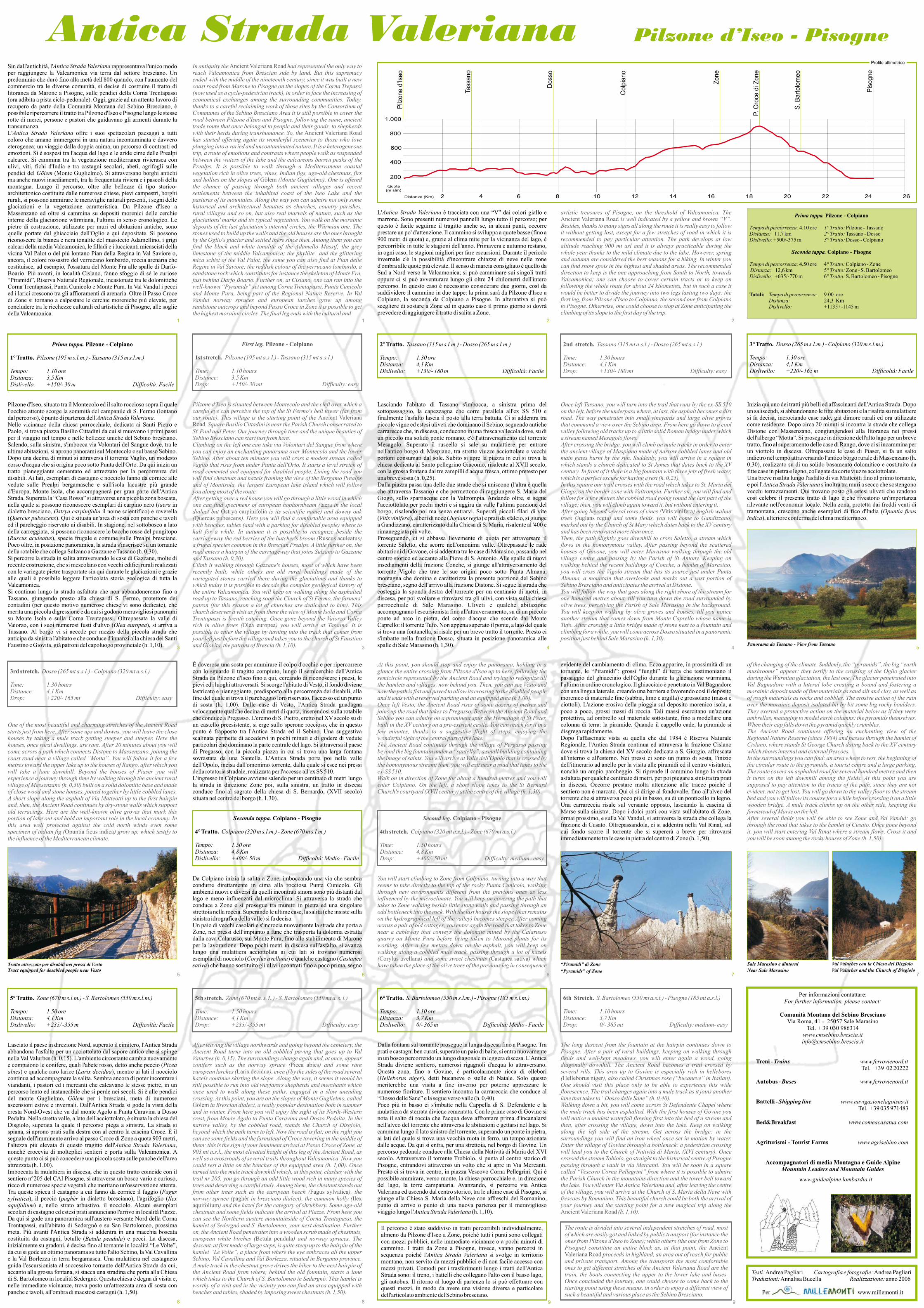
Antica Strada Valeriana Pilzone d’Iseo - Pisogne Sin dall'antichità, l' rappresentava l'unico modo per raggiungere la Valcamonica via terra dal settore bresciano. Un predominio che durò fino alla metà dell'800 quando, con l'aumento del commercio tra le diverse comunità, si decise di costruire il tratto di litoranea da Marone a Pisogne, sulle pendici della Corna Trentapassi (ora adibita a pista ciclo-pedonale). Oggi, grazie ad un attento lavoro di recupero da parte della Comunità Montana del Sebino Bresciano, è possibile ripercorrere il tratto tra Pilzone d'Iseo e Pisogne lungo le stesse rotte di merci, persone e pastori che guidavano gli armenti durante la transumanza. L' offre i suoi spettacolari paesaggi a tutti coloro che amano immergersi in una natura incontaminata e davvero eterogenea; un viaggio dalla doppia anima, un percorso di contrasti ed emozioni. Si è sospesi tra l'acqua del lago e le aride cime delle Prealpi calcaree. Si cammina tra la vegetazione mediterranea rivierasca con ulivi, viti, fichi d'India e tra castagni secolari, abeti, agrifogli sulle pendici del (Monte Guglielmo). Si attraversano borghi antichi ma anche nuovi insediamenti, tra la frequentata riviera e i pascoli della montagna. Lungo il percorso, oltre alle bellezze di tipo storico- architettonico costituite dalle numerose chiese, pievi campestri, borghi rurali, si possono ammirare le meraviglie naturali presenti, i segni delle glaciazioni e la vegetazione caratteristica. Da Pilzone d'Iseo a Massenzano ed oltre si cammina su depositi morenici delle cerchie interne della glaciazione würmiana, l'ultima in senso cronologico. Le pietre di costruzione, utilizzate per muri ed abitazioni antiche, sono quelle portate dal ghiacciaio dell'Oglio e qui depositate. Si possono riconoscere la bianca e nera tonalite del massiccio Adamellino, i grigi calcari della media Valcamonica, le filladi e i luccicanti micascisti della vicina Val Palot o del più lontano Pian della Regina in Val Saviore o, ancora, il colore rossastro del verrucano lombardo, roccia arenaria che costituisce, ad esempio, l'ossatura del Monte Fra alle spalle di Darfo- Boario. Più avanti, in località Cislano, fanno sfoggio di sé le curiose “Piramidi”, Riserva Naturale Regionale, incastonate tra le dolomitiche Corna Trentapassi, Punta Cunicolo e Monte Pura. In Val Vandul i pecci ed i larici crescono tra gli affioramenti di arenaria. Oltre il Passo Croce di Zone si tornano a calpestare le cerchie moreniche più elevate, per concludere tra le ricchezze culturali ed artistiche di Pisogne, alle soglie dellaValcamonica. Antica Strada Valeriana Antica Strada Valeriana Gölem Prima tappa. Pilzone - Colpiano 1° Tratto. Pilzone (195 m s.l.m.) - Tassano (315 m s.l.m.) Tempo: 1.10 ore Distanza: 3,5 Km Dislivello: +150/- 30 m Difficoltà: Facile Pilzone d'Iseo, situato tra il Montecolo ed il salto roccioso sopra il quale l'occhio attento scorge la sommità del campanile di S. Fermo (lontano dal percorso), è punto di partenza dell' Nelle vicinanze della chiesa parrocchiale, dedicata ai Santi Pietro e Paolo, si trova piazza Basilio Cittadini da cui si muovono i primi passi per il viaggio nel tempo e nelle bellezze uniche del Sebino bresciano. Salendo, sulla sinistra, s'imbocca via Volontari del Sangue dove, tra le ultime abitazioni, si aprono panorami sul Montecolo e sul basso Sebino. Dopo una decina di minuti si attraversa il torrente Vaglio, un modesto corso d'acqua che si origina poco sotto Punta dell'Orto. Da qui inizia un tratto pianeggiante cementato ed attrezzato per la percorrenza dei disabili. Ai lati, esemplari di castagno e nocciolo fanno da cornice alle vedute sulle Prealpi bergamasche e sull'isola lacustre più grande d'Europa, Monte Isola, che accompagnerà per gran parte dell'Antica Strada. Superata la “Casa Rossa” si attraversa una piccola zona boscata, nella quale si possono riconoscere esemplari di carpino nero ( in dialetto bresciano, il nome scientifico) e roverella ( ). Qui è situata un'area di sosta con panche e tavoli ed il parcheggio riservato ai disabili. In stagione, nel sottobosco a lato della carreggiata, si possono riconoscere le bacche rosse del pungitopo ( ), specie frugale e comune sulle Prealpi bresciane. Poco oltre, in posizione panoramica, la strada s'inserisce su un tornante della rotabile che collega Sulzano a Gazzane e Tassano (h. 0,30). Si percorre la strada in salita attraversando le case di Gazzane, molte di recente costruzione, che si mescolano con vecchi edifici rurali realizzati con le variegate pietre trasportate sin qui durante le glaciazioni e grazie alle quali è possibile leggere l'articolata storia geologica di tutta la Valcamonica. Si continua lungo la strada asfaltata che non abbandoneremo fino a Tassano, giungendo presto alla chiesa di S. Fermo, protettore dei contadini (per questo motivo numerose chiese vi sono dedicate), che merita una piccola digressione e da cui si godono meravigliosi panorami su Monte Isola e sulla Corna Trentapassi. Oltrepassata la valle di Vaiorzo, con i suoi numerosi fusti d'ulivo ( ), si arriva a Tassano. Al borgo vi si accede per mezzo della piccola strada che anticipa da sinistra l'abitato e che conduce d'innanzi alla chiesa dei Santi Faustino e Giovita, già patroni del capoluogo provinciale (h. 1,10). Antica Strada Valeriana. taera Ostrya carpinifolia Quercus pubescens Ruscus aculeatus Olea europea L' è tracciata con una “V” dai colori giallo e marrone. Sono presenti numerosi pannelli lungo tutto il percorso; per questo è facile seguirne il tragitto anche se, in alcuni punti, occorre prestare un po' d'attenzione. Il cammino si sviluppa a quote basse (fino a 900 metri di quota) e, grazie al clima mite per la vicinanza del lago, è percorribile in tutte le stagioni dell'anno. Primavera e autunno restano, in ogni caso, le stagioni migliori per fare escursioni. Durante il periodo invernale c'è la possibilità d'incontrare chiazze di neve nelle zone d'ombra alle quote più elevate. Il senso di marcia consigliato è quello da Sud a Nord verso la Valcamonica; si può camminare sui singoli tratti oppure ci si può avventurare lungo gli oltre 24 chilometri dell'intero percorso. In questo caso è necessario considerare due giorni, così da suddividere il cammino in due tappe: la prima sarà da Pilzone d'Iseo a Colpiano, la seconda da Colpiano a Pisogne. In alternativa si può scegliere di sostare a Zone ed in questo caso il primo giorno si dovrà prevedere di aggiungere il tratto di salita a Zone. Antica Strada Valeriana Prima tappa. Seconda tappa. Pilzone - Colpiano Colpiano - Pisogne Totali: Tempo di percorrenza: 1° Tratto: 2° Tratto: Tempo di percorrenza: . ° Tratto: Distanza: ° Tratto: 4.10 ore Pilzone - Tassano Tassano - Dosso 4 50 ore 4 Colpiano - Zone 12,6 km 5 Zone - S. Bartolomeo Distanza: Dislivello: 3° Tratto: Dislivello: ° Tratto: Tempo di percorrenza: Distanza: Dislivello: 11,7 km +500/-375 m Dosso - Colpiano +635/-770 m 6 S. Bartolomeo - Pisogne 9.00 ore 24,3 Km +1135 / -1145 m Per informazioni contattare: Via Roma, 41 - 25057 Sale Marasino Tel. + 39 030 986314 For further information, please contact: www.guidealpine.lombardia.it Comunità Montana del Sebino Bresciano Accompagnatori di media Montagna e Guide Alpine www.cmsebino.brescia.it [email protected] www.ferrovienord.it www.navigazionelagoiseo.it www.comeacasatua.com www.agrisebino.com Treni - Autobus - Battelli - Bed&Breakfast Agriturismi - Tourist Farms Trains Buses Shipping line Tel. +39 02 20222 Tel. +39 035 971483 www.ferrovienord.it Mountain Leaders and Mountain Guides Panorama da Tassano - View from Tassano Testi: Cartografia e fotografie: Traduzioni: Realizzazione: Andrea Pagliari Andrea Pagliari Annalisa Bucella anno 2006 Per www.millemonti.it Tract equipped for desabled people near Vesto “Pyramids” of Zone 2° Tratto. Tassano (315 m s.l.m.) - Dosso (265 m s.l.m.) Tempo: 1.30 ore Distanza: 4,1 Km Dislivello: +130/- 180 m Difficoltà: Facile Vitis vinifera Juglans regia Lasciando l'abitato di Tassano s'imbocca, a sinistra prima del sottopassaggio, la capezzagna che corre parallela all'ex SS 510 e finalmente l'asfalto lascia il posto alla terra battuta. Ci si addentra tra piccole vigne ed estesi uliveti che dominano il Sebino, seguendo antiche carrarecce che, in discesa, conducono in una fresca vallecola dove, su di un piccolo ma solido ponte romano, c'è l'attraversamento del torrente Mesagolo. Superato il ruscello si sale su mulattiere per entrare nell'antico borgo di Maspiano, tra strette viuzze acciottolate e vecchi portoni consumati dal sole. Subito si apre la piazza in cui si trova la chiesa dedicata al Santo pellegrino Giacomo, risalente al XVII secolo, con la grossa fontana dai tre zampilli d'acqua fresca, ottimo pretesto per una breve sosta (h. 0,25). Dalla piazza passa una delle due strade che si uniscono (l'altra è quella che attraversa Tassano) e che permettono di raggiungere S. Maria del Giogo, sullo spartiacque con la Valtrompia. Andando oltre, si segue l'acciottolato per pochi metri e si aggira da valle l'ultima porzione del borgo, risalendo poi ma senza entrarvi. Superati piccoli filari di vite ( ), alberi di noce ( ) e prati da sfalcio, si giunge a Gandizzano, caratterizzato dalla Chiesa di S. Maria, risalente al '400 e rimaneggiata più volte. Proseguendo, ci si abbassa lievemente di quota per attraversare il torrente Saletto, che scorre nell'omonima valle. Oltrepassate le rade abitazioni di Gavone, ci si addentra tra le case di Marasino, passando nel centro storico ed accanto alla Pieve di S. Antonio. Alle spalle di nuovi insediamenti della frazione Conche, si giunge all'attraversamento del torrente Vigolo che trae le sue origini poco sotto Punta Almana, montagna che domina e caratterizza la presente porzione del Sebino bresciano, segno dell'arrivo alla frazione Distone. Si segue la strada che costeggia la sponda destra del torrente per un centinaio di metri, in discesa, per poi svoltare e ritrovarsi tra gli ulivi, con vista sulla chiesa parrocchiale di Sale Marasino. Uliveti e qualche abitazione accompagnano l'escursionista fino all'attraversamento, su di un piccolo ponte ad arco in pietra, del corso d'acqua che scende dal Monte Caprello: il torrente Tufo. Non appena superato il ponte, a lato del quale si trova una fontanella, si risale per un breve tratto il torrente. Presto ci s'imbatte nella frazione Dosso, situata in posizione panoramica alle spalle di Sale Marasino (h. 1,30). 3° Tratto. Dosso (265 m s.l.m.) - Colpiano (320 m s.l.m.) Tempo: 1.30 ore Distanza: 4,1 Km Dislivello: +220/- 165 m Difficoltà: Facile Antica Strada Valeriana Opuntia ficus indica Inizia qui uno dei tratti più belli ed affascinanti dell'Antica Strada. Dopo un saliscendi, si abbandonano le fitte abitazioni e la risalita su mulattiere si fa decisa, incrociando case rade, già dimore rurali ed ora utilizzate come residenze. Dopo circa 20 minuti si incontra la strada che collega Distone con Massenzano, congiungendosi alla litoranea nei pressi dell'albergo “Motta”. Si prosegue in direzione dell'alto lago per un breve tratto, fino al superamento delle case di Rango, dove ci si incammina per un viottolo in discesa. Oltrepassate le case di Piaser, si fa un salto indietro nel tempo attraversando l'antico borgo rurale di Massenzano (h. 0,30), realizzato su di un solido basamento dolomitico e costituito da fitte case in pietra e legno, collegate da corte viuzze acciottolate. Una breve risalita lungo l'asfalto di via Matteotti fino al primo tornante, e poi l' s'inoltra tra muri a secco che sostengono vecchi terrazzamenti. Qui trovano posto gli estesi uliveti che rendono così celebre il presente tratto di lago e che rivestono un'importanza rilevante nell'economia locale. Nella zona, protetta dai freddi venti di tramontana, crescono anche esemplari di fico d'India ( ), ulteriore conferma del clima mediterraneo. È doverosa una sosta per ammirare il colpo d'occhio e per ripercorrere con lo sguardo il tragitto compiuto, lungo il semicerchio dell'Antica Strada da Pilzone d'Iseo fino a qui, cercando di riconoscere i paesi, le pievi ed i luoghi attraversati. Si scorge l'abitato diVesto, il fondo diviene lastricato e pianeggiante, predisposto alla percorrenza dei disabili, alla fine del quale si trova il parcheggio loro riservato, l'accesso ed un punto di sosta (h. 1,00). Dalle case di Vesto, l'Antica Strada guadagna velocemente qualche decina di metri di quota, inserendosi sulla rotabile che conduce a Pregasso. L'eremo di S. Pietro, eretto nel XV secolo su di un castello preesistente, si erge sullo sperone roccioso, che in questo punto è frapposto tra l'Antica Strada ed il Sebino. Una suggestiva scalinata permette di accedervi in pochi minuti e di godere di vedute particolari che dominano la parte centrale del lago. Si attraversa il paese di Pregasso, con la piccola piazza in cui si trova una larga fontana sovrastata da una Santella. L'Antica Strada porta poi nella valle dell'Opolo, incisa dall'omonimo torrente, dalla quale si esce nei pressi della rotatoria stradale, realizzata per l'accesso all'ex SS 510. L'ingresso in Colpiano avviene salendo per un centinaio di metri lungo la strada in direzione Zone poi, sulla sinistra, un tratto in discesa conduce fino al sagrato della chiesa di S. Bernardo, (XVII secolo) situata nel centro del borgo (h. 1,30). Da Colpiano inizia la salita a Zone, imboccando una via che sembra condurre direttamente in cima alla rocciosa Punta Cunicolo. Gli ambienti nuovi e diversi da quelli incontrati sinora sono più distanti dal lago e meno influenzati dal microclima. Si attraversa la strada che conduce a Zone e si prosegue tra muretti in pietra ed una singolare strettoia nella roccia. Superando le ultime case, la salita (che insiste sulla sinistra idrografica della valle) si fa decisa. Un paio di vecchi casolari e s'incrocia nuovamente la strada che porta a Zone, nei pressi dell'impianto a fune che trasporta la dolomia estratta dalla cava Calarusso, sul Monte Pura, fino allo stabilimento di Marone per la lavorazione. Dopo pochi metri in discesa sull'asfalto, si avanza lungo una mulattiera acciottolata ai cui lati si trovano numerosi esemplari di nocciolo ( ) e qualche castagno ( ) che hanno sostituito gli ulivi incontrati fino a poco prima, segno Seconda tappa. Colpiano - Pisogne 4° Tratto. Colpiano (320 m s.l.m.) - Zone (670 m s.l.m.) Tempo: 1.50 ore Distanza: 4,8 Km Dislivello: +400/- 50 m Difficoltà: Medio - Facile Corylus avellana Castanea sativa evidente del cambiamento di clima. Ecco apparire, in prossimità di un tornante, le “Piramidi”: grossi “funghi” di terra che testimoniano il passaggio del ghiacciaio dell'Oglio durante la glaciazione würmiana, l'ultima in ordine cronologico. Il ghiacciaio è penetrato in Val Bagnadore con una lingua laterale, creando una barriera e favorendo così il deposito morenico di materiale fine (sabbia, limo e argilla) e grossolano (massi e ciottoli). L'azione erosiva della pioggia sul deposito morenico isola, a poco a poco, grossi massi di roccia. Tali massi esercitano un'azione protettiva, ad ombrello sul materiale sottostante, fino a modellare una colonna di terra: la piramide. Quando il cappello cade, la piramide si disgrega rapidamente. Dopo l'affascinate vista su quella che dal 1984 è Riserva Naturale Regionale, l'Antica Strada continua ed attraversa la frazione Cislano dove si trova la chiesa del XV secolo dedicata a S. Giorgio, affrescata all'interno e all'esterno. Nei pressi ci sono un punto di sosta, l'inizio dell'itinerario ad anello per la visita alle piramidi ed il centro visitatori, nonché un ampio parcheggio. Si riprende il cammino lungo la strada asfaltata per qualche centinaio di metri, per poi piegare a sinistra tra prati in discesa. Occorre prestare molta attenzione alle tracce poiché il sentiero non è marcato. Qui ci si dirige al fondovalle, fino all'alveo del torrente che si attraversa poco più in basso, su di un ponticello in legno. Una carrareccia risale sul versante opposto, lasciando la cascina di Marse sulla sinistra. Dopo i dolci prati con vista sull'abitato di Zone, ormai prossimo, e sulla Val Vandul, si attraversa la strada che collega la frazione di Cusato. Oltrepassandola, ci si addentra nella Val Rinat, sul cui fondo scorre il torrente che si supererà a breve per ritrovarsi immediatamente tra le case in pietra del centro di Zone (h. 1,50). 5° Tratto. Zone (670 m s.l.m.) - S. Bartolomeo (550 m s.l.m.) Tempo: 1.50 ore Distanza: 4,1 Km Dislivello: +235/ -355 m Difficoltà: Facile Picea abies Larix decidua Gölem Antica Strada Valeriana Fagus sylvatica paghèr Ilex aquifolium Betula pendula Lasciato il paese in direzione Nord, superato il cimitero, l'Antica Strada abbandona l'asfalto per un acciottolato dal sapore antico che si spinge nella Val Valurbes (h. 0,15). L'ambiente circostante cambia nuovamente e compaiono le conifere, quali l'abete rosso, detto anche peccio ( ) e qualche raro larice ( ), mentre ai lati il nocciolo continua ad accompagnare la salita. Sembra ancora di poter incontrare i viandanti, i pastori ed i mercanti che calcavano le stesse pietre, in un percorso lento ed instancabile che si perde nei secoli. Si è alle pendici del monte Guglielmo, per i bresciani, meta di numerose ascensioni estive e invernali. Dall'Antica Strada si gode la vista della cresta Nord-Ovest che va dal monte Agolo a Punta Caravina a Dosso Pedalta. Nella stretta valle, a lato dell'acciottolato, è situata la chiesa del Disgiolo, superata la quale il percorso piega a sinistra. La strada si spiana, si aprono prati sulla destra con al centro la cascina Croce. È il segnale dell'imminente arrivo al passo Croce di Zone a quota 903 metri, l'altezza più elevata di questo tragitto dell' , nonché crocevia di molteplici sentieri e porta sulla Valcamonica. A questo punto ci si può concedere una piccola sosta sulle panche dell'area attrezzata (h. 1,00). Imboccata la mulattiera in discesa, che in questo tratto coincide con il sentiero n°205 del CAI Pisogne, si attraversa un bosco vario e curioso, ricco di numerose specie vegetali che meritano un'osservazione attenta. Tra queste spicca il castagno a cui fanno da cornice il faggio ( ), il peccio ( in dialetto bresciano), l'agrifoglio ( ) e, nello strato arbustivo, il nocciolo. Alcuni esemplari secolari di castagno ed estesi prati annunciano l'arrivo in località Piazze. Da qui si gode una panoramica sull'austero versante Nord della Corna Trentapassi, sull'abitato di Sedergnò e su San Bartolomeo, prossima meta. Più avanti l'Antica Strada si addentra in una macchia boscata costituita da castagni, betulle ( ) e pecci. La discesa, inizialmente su gradoni, è decisa fino al tornante in località “Le Volte”, da cui si gode un ottimo panorama su tutto l'alto Sebino, la Val Cavallina e la Val Borlezza in terra bergamasca. Una mulattiera nel castagneto guida l'escursionista al successivo tornante dell'Antica Strada da cui, accanto alla grossa fontana, si stacca una stradina che porta alla Chiesa di S. Bartolomeo in località Sedergnò. Questa chiesa è degna di visita e, nelle immediate vicinanze, trova posto un'attrezzata area di sosta con panche e tavoli, all'ombra di maestosi castagni (h. 1,50). 6° Tratto. - S. Bartolomeo (550 m s.l.m.) Pisogne (185 m s.l.m.) Tempo: 1.10 ore Distanza: 3,7 Km Dislivello: 0/- 365 m Difficoltà: Medio - Facile Helleborus niger Antica Strada Valeriana Dalla fontana sul tornante prosegue la lunga discesa fino a Pisogne. Tra prati e castagni ben curati, superate un paio di baite, si entra nuovamente in un bosco percorrendo un lungo diagonale in leggera discesa. L'Antica Strada diviene sentiero, numerosi rigagnoli d'acqua lo attraversano. Questa zona, fino a Govine, è particolarmente ricca di ellebori ( ), detti bucaneve o stelle di Natale. Solo questo meriterebbe una visita a fine inverno per poterne apprezzare le numerose fioriture. Il sentiero incontra la carrareccia che conduce al “Dosso delle Sane” e la segue verso valle (h. 0,40). Poco più in basso ci s'imbatte nella Cappella di S. Defendente e la mulattiera da sterrata diviene cementata. Con le prime case di Govine si nota il salto di roccia che l'acqua deve affrontare prima d'incanalarsi nell'alveo del torrente che attraversa le abitazioni e gettarsi nel lago. Si cammina lungo il lato sinistro del torrente, superando un ponte in pietra, ai lati del quale si trova una vecchia ruota in ferro, un tempo azionata dalle acque. Da qui si entra, per una strettoia, nel borgo di Govine. Un percorso pedonale conduce alla Chiesa della Natività di Maria del XVI secolo. Attraversato il torrente Trobiolo, si punta al centro storico di Pisogne, entrandovi attraverso un volto che si apre in Via Mercanti. Presto ci si trova in centro, in piazza Vescovo Corna Pellegrini. Qui è possibile ammirare, verso monte, la chiesa parrocchiale e, in direzione del lago, la torre campanaria. Avanzando, si percorre via Antica Valeriana ed uscendo dal centro storico, tra le ultime case di Pisogne, si giunge alla Chiesa S. Maria della Neve con affreschi del Romanino, punto di arrivo o punto di una nuova partenza per il meraviglioso viaggio lungo l' (h. 1,10). In antiquity the had represented the only way to reach Valcamonica from Brescian side by land. But this supremacy ended with the middle of the nineteenth century, since it was built a new coast road from Marone to Pisogne on the slopes of the Corna Trepassi (now used as a cycle-pedestrian track), in order to face the increasing of economical exchanges among the surrounding communities. Today, thanks to a careful reclaiming work of those sites by the Consortium of Communes of the Sebino Bresciano Area it is still possible to cover the road between Pilzone d'Iseo and Pisogne, following the same, ancient trade route that once belonged to people and their goods, to shepherds with their herds during transhumance. So, the has started offering again its wonderful sceneries to those who love plunging into a varied and uncontaminated nature. It is a heterogeneous trip, a route of emotions and contrasts where people walk as suspended between the waters of the lake and the calcareous barren peaks of the Prealps. It is possible to walk through a Mediterranean coastal vegetation rich in olive trees, vines, Indian figs, age-old chestnuts, firs and hollies on the slopes of (Monte Guglielmo). One is offered the chance of passing through both ancient villages and recent settlements between the inhabited coast of the Iseo Lake and the pastures of its mountains. Along the way you can admire not only some historical and architectural beauties as churches, country parishes, rural villages and so on, but also real marvels of nature, such as the glaciations' marks and its typical vegetation. You walk on the morainic deposits of the last glaciation's internal circles, the Würmian one. The stones used to build up the walls and the old houses are the ones brought by the Oglio's glacier and settled there since then. Among them you can find the black and white tonalite of the Adamello Massif; the grey limestone of the middle Valcamonica; the phyllite and the glittering mica schist of the Val Palot, the same you can also find at Pian delle Regine in Val Saviore; the reddish colour of the verrucano lombardo, a sandstone rock which constitutes for instance the skeleton of Monte Fra, just behind Darfo Boario. Further on, at Cislano, one can run into the well-known “Pyramids” set among Corna Trentapassi, Punta Cunicolo and Monte Pura, being part of the Regional Nature Reserve. In Val Vandul norway spruces and european larches grow up among sandstone outcrops and beyond Passo Croce in Zone it is possible to get the highest morainic circles. The final leg ends with the cultural and Ancient Valeriana Road Ancient Valeriana Road Gölem artistic treasures of Pisogne, on the threshold of Valcamonica. The is well indicated by a yellow and brown “V”. Besides, thanks to many signs all along the route it is really easy to follow it without getting lost, except for a few stretches of road in which it is recommended to pay particular attention. The path develops at low altitude reaching 900 mt asl and it is always practicable during the whole year thanks to the mild climate due to the lake. However, spring and autumn are considered the best seasons for a hiking. In winter you can find snow spots in the highest and shaded areas. The recommended direction to keep is the one approaching from South to North, towards Valcamonica; one can choose to cover certain tracts or to keep on following the whole route for about 24 kilometres, but in such a case it would be better to divide the journey into two legs lasting two days: the first leg, from Pilzone d'Iseo to Colpiano, the second one from Colpiano to Pisogne. Otherwise, one could choose to stop at Zone anticipating the climbing of its slope to the first day of the trip. Ancient Valeriana Road First leg. Pilzone - Colpiano 1st stretch. Pilzone (195 mt a.s.l.) - Tassano (315 mt a.s.l.) Time: 1.10 hours Distance: 3,5 Km Drop: +150/- 30 mt Difficulty: easy Pilzone d'Iseo is situated between Montecolo and the cleft over which a careful eye can perceive the top of the St Fermo's bell tower (far from our route). This village is the starting point of the . Square Basilio Cittadini is near the Parish Church consecrated to St Paul and Peter. Our journey through time and the unique beauties of Sebino Bresciano can start just from here. Climbing on the left one can take via Volontari del Sangue from where you can enjoy an enchanting panorama over Montecolo and the lower Sebino. After about ten minutes you will cross a modest stream called Vaglio that rises from under Punta dell'Orto. It starts a level stretch of road cemented and equipped for disabled people. Lining the road you will find chestnuts and hazels framing the view of the Bergamo Prealps and of Montisola, the largest European lake island which will follow you along most of the route. After getting over a red house you will go through a little wood in which one can find specimens of european hophornbeam ( in the local dialect but is its scientific name) and downy oak ( ). Here you will find a comfortable area equipped with benches, tables (and with a parking for disabled people) where to halt for a while. In autumn it is possible to recognize beside the carriageway the red berries of the butcher's broom ( ) a frugal species common in the Brescian Prealps. A little further on, the road enters a hairpin of the carriageway that joins Sulzano to Gazzane and Tassano (h. 0,30). Climb it walking through Gazzane's houses, most of which have been recently built, while others are old rural buildings made of the variegated stones carried there during the glaciations and thanks to which today it is possible to decode the complex geological history of the entire Valcamonica. You will keep on walking along the asphalted road up to Tassano, reaching soon the Church of St Fermo, the farmers' patron (for this reason a lot of churches are dedicated to him). This church deserves a visit as from there the view of Monte Isola and Corna Trentapassi is breath catching. Once gone beyond the Vaiorzo Valley rich in olive trees ( ) you will arrive at Tassano. It is possible to enter the village by turning into the track that comes from your left just before the village and takes you to the church of St Faustino and Giovita, the patrons of Brescia (h. 1,10). Ancient Valeriana Road taera Ostrya carpinifolia Quercus pubescens Ruscus aculeatus Olea europea s 2nd stretch. Tassano (315 mt a.s.l.) - Dosso (265 mt a.s.l.) Time: 1.30 hours Distance: 4,1 Km Drop: +130/- 180 mt Difficulty: easy Once left Tassano, you will turn into the trail that runs by the ex-SS 510 on the left, before the underpass where, at last, the asphalt becomes a dirt road. The way penetrates into small vineyards and large olive groves that command a view over the Sebino area. From here go down to a cool valley following old tracks up to a little solid Roman bridge under which a stream named Mesagolo flows. After crossing the bridge, you will climb on mule tracks in order to enter the ancient village of Maspiano made of narrow cobbled lanes and old main gates burnt by the sun. Suddenly, you will arrive in a square in which stands a church dedicated to St James that dates back to the XV century. In front of it there is a big fountain with three jets of fresh water, which is a perfect excuse for having a rest (h. 0,25). In this square our trail crosses with the road which takes to St. Maria del Giogo, on the border zone with Valtrompia. Further on, you will find and follow for a few metres the cobbled road going round the last part of the village; then, you will climb again toward it, but without entering it. After going beyond several rows of vines ( ) english walnut trees ( ) and some fields, you will come to Gandizzano, marked out by the Church of St Mary which dates back to the XV century and has been renovated more than once. Then, the path slightly goes downhill to cross Saletto, a stream which flows in the homonymous valley. After passing beyond the scattered houses of Gavone, you will enter Marasino walking through the old village centre and passing by the Parish of St Antony. Keeping on walking behind the recent buildings of Conche, a hamlet of Marasino, you will cross the Vigolo stream that has its source just under Punta Almana, a mountain that overlooks and marks out a vast portion of Sebino Bresciano and anticipates the arrival at Distone. You will follow the way that goes along the right shore of the stream for one hundred metres about, till you turn down the road surrounded by olive trees, perceiving the Parish of Sale Marasino in the background. You will keep on walking by olive groves and houses, till you notice another stream that comes down from Monte Caprello whose name is Tufo. After crossing a little bridge made of stone next to a fountain and climbing for a while, you will come across Dosso situated in a panoramic position just behind Sale Marasino (h. 1,30). Vitis vinifera Juglans regia 3rd stretch. Dosso (265 mt a.s.l.) - Colpiano (320 mt a.s.l.) Time: 1.30 hours Distance: 4,1 Km Drop: +220/- 165 mt Difficulty: easy One of the most beautiful and charming stretches of the Ancient Road starts just from here. After some ups and downs, you will leave the close houses by taking a mule track getting steeper and steeper. Here the houses, once rural dwellings, are rare. After 20 minutes about you will come across a path which connects Distone to Massenzano, joining the coast road near a village called “Motta”. You will follow it for a few metres toward the upper lake up to the houses of Rango, after which you will take a lane downhill. Beyond the houses of Piaser you will experience a journey through time by walking through the ancient rural village of Massenzano (h. 0,30) built on a solid dolomitic base and made of close wood and stone houses, joined together by little cobbled lanes. A short slope along the asphalt of Via Matteotti up to the first hairpin and, then, the Ancient Road continues by dry-stone walls which support old terracings. Here are the well-known olive groves that mark this portion of lake out and hold an important role in the local economy. In this area well protected against the cold north winds even some specimen of indian fig ( ) grow up, which testify to the influence of the Mediterranean climate. Opuntia ficus indica At this point, you should stop and enjoy the panorama, holding in a glance the entire crossing from Pilzone d'Iseo up to here, following the semicircle represented by the Ancient Road and trying to recognize all the hamlets and villages, now behind you. Then, you can see Vesto and now the path is flat and paved to allow its crossing to the disabled people and it ends with a reserved parking and an equipped area (h 1.00). Once left Vesto, the Ancient Road rises of some dozens of metres and joins up the road that takes to Pregasso. Between the Ancient Road and Sebino you can admire on a prominent spur the Hermitage of St Peter, built in the XV century on a pre-existent castle. You can reach for it in a few minutes, thanks to a suggestive flight of steps, enjoying the wonderful sight of the central part of the lake. The Ancient Road continues through the village of Pergasso passing beyond the big fountain under a “santella”, a small building containing the image of saints. You will arrive at Valle dell'Opolo that is crossed by the homonymous stream; then, you will exit near a road that takes to the ex-SS 510. Walk on in direction of Zone for about a hundred metres and you will enter Colpiano. On the left, a short slope takes to the St Bernard Church's courtyard (XVII century) at the centre of the village (h. 1,30). Second leg. Colpiano - Pisogne 4th stretch. Colpiano (320 mt a.s.l.) - Zone (670 mt a.s.l.) Time: 1.50 hours Distance: 4,8 Km Drop: +400/- 50 mt Difficulty: medium - easy You will start climbing to Zone from Colpiano, turning into a way that seems to take directly to the top of the rocky Punta Cunicolo, walking through new environments different from the previous ones as less influenced by the microclimate. You will keep on covering the path that takes to Zone walking beside little stone walls and passing through an odd bottleneck into the rock. With the last houses the slope (that remains on the hydrographical left of the valley) becomes steeper. After coming across a pair of old cottages, you enter again the road that takes to Zone near a cableway that conveys the dolomite mined by the Calarusso quarry on Monte Pura before being taken to Marone plants for its working. After a few metres down on the asphalt, you will keep on walking along a cobbled mule track, passing through a lot of hazels ( ) and some sweet chestnuts ( ) which have taken the place of the olive trees of the previous leg in consequence Corylus avellana Castanea sativa of the changing of the climate. Suddenly, the “pyramids”, the big “earth mushrooms” appear: they testify to the crossing of the Oglio glacier during the Würmian glaciation, the last one. The glacier penetrated into Val Bagnadore with a lateral lobe creating a bound and fostering a morainic deposit made of fine materials as sand silt and clay, as well as of rough materials as rocks and cobbles. The erosive action of the rain over the morainic deposit isolated bit by bit some big rocky boulders. They exerted a protective action on the material below as if they were umbrellas, managing to model earth columns: the pyramids themselves. When their cap falls down the pyramid quickly crumbles. The Ancient Road continues offering an enchanting view of the Regional Nature Reserve (since 1984) and passes through the hamlet of Cislano, where stands St George Church dating back to the XV century which shows internal and external frescoes. In the surroundings you can find: an area where to rest, the beginning of the circular route to the pyramids, a tourist centre and a large parking. The route covers an asphalted road for several hundred metres and then it turns on the left downhill among the fields. At this point you are supposed to pay attention to the traces of the path, since they are not evident, not to get lost. You will go down to the valley floor to the stream bed and you will follow its course for a while before crossing it on a little wooden bridge. A mule track climbs up on the other side, keeping the farmstead of Marse on the left. After several fields you will be able to see Zone and Val Vandul: go through the road that takes to the hamlet of Cusato. Once gone beyond it, you will start entering Val Rinat where a stream flows. Cross it and you will be soon among the rocky houses of Zone (h. 1,50). 5th stretch. Zone (670 mt a. s. L.) - S. Bartolomeo (550 mt a. s. l.) Time: 1.50 hours Distance: 4,1 Km Drop: +235/ -355 mt Difficulty: easy After leaving the village northwards and going beyond the cemetery, the Ancient Road turns into an old cobbled paving that goes up to Val Valurbes (h. 0,15). The surroundings change again and, at once, appear conifers such as the norway spruce ( ) and some rare european larches ( ), even if by the sides of the road several hazels continue skirting the slope. Along the way, it seems it would be still possible to run into old wayfarers shepherds and merchants which once used to walk along these paths, engaged in a slow unending crossing. At this point, you are on the slopes of Monte Guglielmo, called in Brescian dialect, a really popular destination both in summer and in winter. From here you will enjoy the sight of its North-Western crest, from Monte Agolo to Punta Caravina and Dosso Pedalta. In the narrow valley, by the cobbled road, stands the Church of Disgiolo, beyond which the path turns to left. Now the road is flat; on the right you can see some fields and the farmstead of Croce towering in the middle of them: this is the sign of your imminent arrival at Passo Croce of Zone, at 903 mt a.s.l., the most elevated height of this leg of the Ancient Road, as well as a crossroads of several trails throughout Valcamonica. Now you could rest a little on the benches of the equipped area (h. 1,00). Once turned into the mule track downhill which, at this point, clashes with the trail nr 205, you go through an odd little wood rich in many species of trees and deserving a careful study.Among them, the chestnut stands out from other trees such as the european beech ( ), the norway spruce ( in bresciano dialect), the common holly ( ) and the hazel for the category of shrubbery. Some age-old chestnuts and some fields indicate the arrival at Piazze. From here you can see the Northern austere mountainside of Corna Trentapassi, the hamlet of Sedergnò and S. Bartolomeo, your next destination. Further on, the Ancient Road penetrates into a wooden scrub made of chestnuts, european white birches ( ) and norway spruces. The descent, at first made of large steps, is quite steep up to the hairpin of the hamlet “Le Volte”, a place from where the eye embraces all the upper Sebino, Val Cavallina and Val Borlezza, situated in Bergamo province. A mule track in the chestnut grove drives the hiker to the next hairpin of the Ancient Road from where, behind the old fountain, starts a lane which takes to the Church of S. Bartolomeo in Sedergnò. This hamlet is worthy of a visit and in the vicinity you can find an area equipped with benches and tables, shaded by imposing sweet chestnuts (h. 1,50). Picea abies Larix decidua Gölem Fagus sylvatica paghèr Ilex aquifolium Betula pendula 6th Stretch. S. Bartolomeo (550 mt a.s.l.) - Pisogne (185 mt a.s.l.) Time: 1.10 hours Distance: 3,7 Km Drop: 0/- 365 mt Difficulty: medium- easy The long descent from the fountain at the hairpin continues down to Pisogne. After a pair of rural buildings, keeping on walking through fields and well-kept meadows, you will enter again a wood, going diagonally downhill. The Ancient Road becomes a trail crossed by several rills. This area up to Govine is especially rich in hellebores ( ), also called Christmas rose (“bucaneve” in Italian). One should visit this place only to be able to experience this wide florescence. The trail changes again into a mule track as it joins another lane that takes to “Dosso delle Sane” (h. 0,40). Walking down a bit, you will come across St Defendente Chapel where the mule track has been asphalted. With the first houses of Govine you will notice a modest waterfall flowing first into the bed of a stream and then, after crossing the village, down into the lake. Keep on walking along the left side of the stream. Get across the bridge: in the surroundings you will find an iron wheel once set in motion by water. Enter the village of Govine through a bottleneck: a pedestrian crossing will lead you to the Church of Natività di Maria, (XVI century). Once crossed the stream Tobiolo, go straight to the historical centre of Pisogne passing through a vault in via Mercanti. You will be soon in a square called “Vescovo Corna Pellegrini” from where it is possible to admire the Parish Church in the mountains direction and the tower bell toward the lake. You will enter Via Antica Valeriana and, after leaving the centre of the village, you will arrive at the Church of S. Maria della Neve with frescoes by Romanino. This beautiful church could be both the arrival of your journey and the starting point for a new magical trip along the (h. 1,10). Helleborus niger AncientValeriana Road Sale Marasino e dintorni 200 400 600 800 1.000 2 4 6 8 10 12 14 16 18 20 22 24 26 Pilzone d’Iseo P. Croce di Zone Pisogne Tassano Dosso Colpiano Zone S. Bartolomeo Distanza (Km) Quota (m slm) Profilo altimetrico Tratto attrezzato per disabili nei pressi di Vesto Val Valurbescon la Chiesa del Disgiolo Val Valurbes and the Church of Disgiolo Near Sale Marasino 1 2 3 4 5 6 7 8 9 1 2 4 5 3 6 7 8 9 Il percorso è stato suddiviso in tratti percorribili individualmente, almeno da Pilzone d'Iseo a Zone, poiché tutti i punti sono collegati con mezzi pubblici, nelle immediate vicinanze o a pochi minuti di cammino. I tratti da Zone a Pisogne, invece, vanno percorsi in sequenza poiché l' si svolge in territorio montano, non servito da mezzi pubblici e di non facile accesso con mezzi privati. Comodi per i trasferimenti lungo i tratti dell'Antica Strada sono: il treno, i battelli che collegano l'alto con il basso lago, gli autobus. Il ritorno al luogo di partenza lo si può effettuare con questi mezzi, in modo da avere una visione diversa e particolare dell'articolato ambiente del Sebino bresciano. Antica Strada Valeriana The route is divided into several independent stretches of road, most of which are easily got and linked by public transport (for instance the ones from Pilzone d'Iseo to Zone); while others (the one from Zone to Pisogne) constitute an entire block as, at that point, the proceeds in highland, an area out of reach for public and private transport. Among the transports the most comfortable ones to get different stretches of theAncient Valeriana Road are the train, the boats connecting the upper to the lower lake and buses. Once concluded the journey, one could choose to come back to the starting point using these means, in order to enjoy a different view of such a beautiful and various place as the Sebino Bresciano. Ancient Valeriana Road “Piramidi” di Zone
Transcript of Antica Strada Valeriana - visitlakeiseo.info · rotte di merci, persone e pastori che guidavano gli...
Antica Strada Valeriana Pilzone d’Iseo - Pisogne
Sin dall'antichità, l' rappresentava l'unico modoper raggiungere la Valcamonica via terra dal settore bresciano. Unpredominio che durò fino alla metà dell'800 quando, con l'aumento delcommercio tra le diverse comunità, si decise di costruire il tratto dilitoranea da Marone a Pisogne, sulle pendici della Corna Trentapassi(ora adibita a pista ciclo-pedonale). Oggi, grazie ad un attento lavoro direcupero da parte della Comunità Montana del Sebino Bresciano, èpossibile ripercorrere il tratto tra Pilzone d'Iseo e Pisogne lungo le stesserotte di merci, persone e pastori che guidavano gli armenti durante latransumanza.L' offre i suoi spettacolari paesaggi a tutticoloro che amano immergersi in una natura incontaminata e davveroeterogenea; un viaggio dalla doppia anima, un percorso di contrasti edemozioni. Si è sospesi tra l'acqua del lago e le aride cime delle Prealpicalcaree. Si cammina tra la vegetazione mediterranea rivierasca conulivi, viti, fichi d'India e tra castagni secolari, abeti, agrifogli sullependici del (Monte Guglielmo). Si attraversano borghi antichima anche nuovi insediamenti, tra la frequentata riviera e i pascoli dellamontagna. Lungo il percorso, oltre alle bellezze di tipo storico-architettonico costituite dalle numerose chiese, pievi campestri, borghirurali, si possono ammirare le meraviglie naturali presenti, i segni delleglaciazioni e la vegetazione caratteristica. Da Pilzone d'Iseo aMassenzano ed oltre si cammina su depositi morenici delle cerchieinterne della glaciazione würmiana, l'ultima in senso cronologico. Lepietre di costruzione, utilizzate per muri ed abitazioni antiche, sonoquelle portate dal ghiacciaio dell'Oglio e qui depositate. Si possonoriconoscere la bianca e nera tonalite del massiccio Adamellino, i grigicalcari della media Valcamonica, le filladi e i luccicanti micascisti dellavicina Val Palot o del più lontano Pian della Regina in Val Saviore o,ancora, il colore rossastro del verrucano lombardo, roccia arenaria checostituisce, ad esempio, l'ossatura del Monte Fra alle spalle di Darfo-Boario. Più avanti, in località Cislano, fanno sfoggio di sé le curiose“Piramidi”, Riserva Naturale Regionale, incastonate tra le dolomiticheCorna Trentapassi, Punta Cunicolo e Monte Pura. In Val Vandul i peccied i larici crescono tra gli affioramenti di arenaria. Oltre il Passo Crocedi Zone si tornano a calpestare le cerchie moreniche più elevate, perconcludere tra le ricchezze culturali ed artistiche di Pisogne, alle sogliedella Valcamonica.
Antica Strada Valeriana
Antica Strada Valeriana
Gölem
Prima tappa. Pilzone - Colpiano
1° Tratto. Pilzone (195 m s.l.m.) - Tassano (315 m s.l.m.)
Tempo: 1.10 oreDistanza: 3,5 KmDislivello: +150/- 30 m Difficoltà: Facile
Pilzone d'Iseo, situato tra il Montecolo ed il salto roccioso sopra il qualel'occhio attento scorge la sommità del campanile di S. Fermo (lontanodal percorso), è punto di partenza dell'Nelle vicinanze della chiesa parrocchiale, dedicata ai Santi Pietro ePaolo, si trova piazza Basilio Cittadini da cui si muovono i primi passiper il viaggio nel tempo e nelle bellezze uniche del Sebino bresciano.Salendo, sulla sinistra, s'imbocca via Volontari del Sangue dove, tra leultime abitazioni, si aprono panorami sul Montecolo e sul basso Sebino.Dopo una decina di minuti si attraversa il torrente Vaglio, un modestocorso d'acqua che si origina poco sotto Punta dell'Orto. Da qui inizia untratto pianeggiante cementato ed attrezzato per la percorrenza deidisabili. Ai lati, esemplari di castagno e nocciolo fanno da cornice allevedute sulle Prealpi bergamasche e sull'isola lacustre più granded'Europa, Monte Isola, che accompagnerà per gran parte dell'AnticaStrada. Superata la “Casa Rossa” si attraversa una piccola zona boscata,nella quale si possono riconoscere esemplari di carpino nero ( indialetto bresciano, il nome scientifico) e roverella( ). Qui è situata un'area di sosta con panche e tavolied il parcheggio riservato ai disabili. In stagione, nel sottobosco a latodella carreggiata, si possono riconoscere le bacche rosse del pungitopo( ), specie frugale e comune sulle Prealpi bresciane.Poco oltre, in posizione panoramica, la strada s'inserisce su un tornantedella rotabile che collega Sulzano a Gazzane e Tassano (h. 0,30).Si percorre la strada in salita attraversando le case di Gazzane, molte direcente costruzione, che si mescolano con vecchi edifici rurali realizzaticon le variegate pietre trasportate sin qui durante le glaciazioni e graziealle quali è possibile leggere l'articolata storia geologica di tutta laValcamonica.Si continua lungo la strada asfaltata che non abbandoneremo fino aTassano, giungendo presto alla chiesa di S. Fermo, protettore deicontadini (per questo motivo numerose chiese vi sono dedicate), chemerita una piccola digressione e da cui si godono meravigliosi panoramisu Monte Isola e sulla Corna Trentapassi. Oltrepassata la valle diVaiorzo, con i suoi numerosi fusti d'ulivo ( ), si arriva aTassano. Al borgo vi si accede per mezzo della piccola strada cheanticipa da sinistra l'abitato e che conduce d'innanzi alla chiesa dei SantiFaustino e Giovita, già patroni del capoluogo provinciale (h. 1,10).
Antica Strada Valeriana.
taeraOstrya carpinifolia
Quercus pubescens
Ruscus aculeatus
Olea europea
L' è tracciata con una “V” dai colori giallo emarrone. Sono presenti numerosi pannelli lungo tutto il percorso; perquesto è facile seguirne il tragitto anche se, in alcuni punti, occorreprestare un po' d'attenzione. Il cammino si sviluppa a quote basse (fino a900 metri di quota) e, grazie al clima mite per la vicinanza del lago, èpercorribile in tutte le stagioni dell'anno. Primavera e autunno restano,in ogni caso, le stagioni migliori per fare escursioni. Durante il periodoinvernale c'è la possibilità d'incontrare chiazze di neve nelle zoned'ombra alle quote più elevate. Il senso di marcia consigliato è quello daSud a Nord verso la Valcamonica; si può camminare sui singoli trattioppure ci si può avventurare lungo gli oltre 24 chilometri dell'interopercorso. In questo caso è necessario considerare due giorni, così dasuddividere il cammino in due tappe: la prima sarà da Pilzone d'Iseo aColpiano, la seconda da Colpiano a Pisogne. In alternativa si puòscegliere di sostare a Zone ed in questo caso il primo giorno si dovràprevedere di aggiungere il tratto di salita a Zone.
Antica Strada ValerianaPrima tappa.
Seconda tappa.
Pilzone - Colpiano
Colpiano - Pisogne
Totali:
Tempo di percorrenza: 1° Tratto:2° Tratto:
Tempo di percorrenza: . ° Tratto:Distanza: ° Tratto:
4.10 ore Pilzone - TassanoTassano - Dosso
4 50 ore 4 Colpiano - Zone12,6 km 5 Zone - S. Bartolomeo
Distanza:Dislivello: 3° Tratto:
Dislivello: ° Tratto:
Tempo di percorrenza:Distanza:Dislivello:
11,7 km+500/-375 m Dosso - Colpiano
+635/-770 m 6 S. Bartolomeo - Pisogne
9.00 ore24,3 Km+1135 / -1145 m
Per informazioni contattare:
Via Roma, 41 - 25057 Sale MarasinoTel. + 39 030 986314
For further information, please contact:
www.guidealpine.lombardia.it
Comunità Montana del Sebino Bresciano
Accompagnatori di media Montagna e Guide Alpine
www.ferrovienord.it
www.navigazionelagoiseo.it
www.comeacasatua.com
www.agrisebino.com
Treni -
Autobus -
Battelli -
Bed&Breakfast
Agriturismi - Tourist Farms
Trains
Buses
Shipping line
Tel. +39 02 20222
Tel. +39 035 971483
www.ferrovienord.it
Mountain Leaders and Mountain Guides
Panorama da Tassano - View from Tassano
Testi: Cartografia e fotografie:Traduzioni: Realizzazione:
Andrea Pagliari Andrea PagliariAnnalisa Bucella anno 2006
Per www.millemonti.it
Tract equipped for desabled people near Vesto “Pyramids” of Zone
2° Tratto. Tassano (315 m s.l.m.) - Dosso (265 m s.l.m.)
Tempo: 1.30 oreDistanza: 4,1 KmDislivello: +130/- 180 m Difficoltà: Facile
Vitis vinifera Juglans regia
Lasciando l'abitato di Tassano s'imbocca, a sinistra prima delsottopassaggio, la capezzagna che corre parallela all'ex SS 510 efinalmente l'asfalto lascia il posto alla terra battuta. Ci si addentra trapiccole vigne ed estesi uliveti che dominano il Sebino, seguendo antichecarrarecce che, in discesa, conducono in una fresca vallecola dove, su diun piccolo ma solido ponte romano, c'è l'attraversamento del torrenteMesagolo. Superato il ruscello si sale su mulattiere per entrarenell'antico borgo di Maspiano, tra strette viuzze acciottolate e vecchiportoni consumati dal sole. Subito si apre la piazza in cui si trova lachiesa dedicata al Santo pellegrino Giacomo, risalente al XVII secolo,con la grossa fontana dai tre zampilli d'acqua fresca, ottimo pretesto peruna breve sosta (h. 0,25).Dalla piazza passa una delle due strade che si uniscono (l'altra è quellache attraversa Tassano) e che permettono di raggiungere S. Maria delGiogo, sullo spartiacque con la Valtrompia. Andando oltre, si seguel'acciottolato per pochi metri e si aggira da valle l'ultima porzione delborgo, risalendo poi ma senza entrarvi. Superati piccoli filari di vite( ), alberi di noce ( ) e prati da sfalcio, si giungea Gandizzano, caratterizzato dalla Chiesa di S. Maria, risalente al '400 erimaneggiata più volte.Proseguendo, ci si abbassa lievemente di quota per attraversare iltorrente Saletto, che scorre nell'omonima valle. Oltrepassate le radeabitazioni di Gavone, ci si addentra tra le case di Marasino, passando nelcentro storico ed accanto alla Pieve di S. Antonio. Alle spalle di nuoviinsediamenti della frazione Conche, si giunge all'attraversamento deltorrente Vigolo che trae le sue origini poco sotto Punta Almana,montagna che domina e caratterizza la presente porzione del Sebinobresciano, segno dell'arrivo alla frazione Distone. Si segue la strada checosteggia la sponda destra del torrente per un centinaio di metri, indiscesa, per poi svoltare e ritrovarsi tra gli ulivi, con vista sulla chiesaparrocchiale di Sale Marasino. Uliveti e qualche abitazioneaccompagnano l'escursionista fino all'attraversamento, su di un piccoloponte ad arco in pietra, del corso d'acqua che scende dal MonteCaprello: il torrente Tufo. Non appena superato il ponte, a lato del qualesi trova una fontanella, si risale per un breve tratto il torrente. Presto cis'imbatte nella frazione Dosso, situata in posizione panoramica allespalle di Sale Marasino (h. 1,30).
3° Tratto. Dosso (265 m s.l.m.) - Colpiano (320 m s.l.m.)
Tempo: 1.30 oreDistanza: 4,1 KmDislivello: +220/- 165 m Difficoltà: Facile
Antica Strada Valeriana
Opuntia ficusindica
Inizia qui uno dei tratti più belli ed affascinanti dell'Antica Strada. Dopoun saliscendi, si abbandonano le fitte abitazioni e la risalita su mulattieresi fa decisa, incrociando case rade, già dimore rurali ed ora utilizzatecome residenze. Dopo circa 20 minuti si incontra la strada che collegaDistone con Massenzano, congiungendosi alla litoranea nei pressidell'albergo “Motta”. Si prosegue in direzione dell'alto lago per un brevetratto, fino al superamento delle case di Rango, dove ci si incammina perun viottolo in discesa. Oltrepassate le case di Piaser, si fa un saltoindietro nel tempo attraversando l'antico borgo rurale di Massenzano (h.0,30), realizzato su di un solido basamento dolomitico e costituito dafitte case in pietra e legno, collegate da corte viuzze acciottolate.Una breve risalita lungo l'asfalto di via Matteotti fino al primo tornante,e poi l' s'inoltra tra muri a secco che sostengonovecchi terrazzamenti. Qui trovano posto gli estesi uliveti che rendonocosì celebre il presente tratto di lago e che rivestono un'importanzarilevante nell'economia locale. Nella zona, protetta dai freddi venti ditramontana, crescono anche esemplari di fico d'India (
), ulteriore conferma del clima mediterraneo.
È doverosa una sosta per ammirare il colpo d'occhio e per ripercorrerecon lo sguardo il tragitto compiuto, lungo il semicerchio dell'AnticaStrada da Pilzone d'Iseo fino a qui, cercando di riconoscere i paesi, lepievi ed i luoghi attraversati. Si scorge l'abitato di Vesto, il fondo divienelastricato e pianeggiante, predisposto alla percorrenza dei disabili, allafine del quale si trova il parcheggio loro riservato, l'accesso ed un puntodi sosta (h. 1,00). Dalle case di Vesto, l'Antica Strada guadagnavelocemente qualche decina di metri di quota, inserendosi sulla rotabileche conduce a Pregasso. L'eremo di S. Pietro, eretto nel XV secolo su diun castello preesistente, si erge sullo sperone roccioso, che in questopunto è frapposto tra l'Antica Strada ed il Sebino. Una suggestivascalinata permette di accedervi in pochi minuti e di godere di veduteparticolari che dominano la parte centrale del lago. Si attraversa il paesedi Pregasso, con la piccola piazza in cui si trova una larga fontanasovrastata da una Santella. L'Antica Strada porta poi nella valledell'Opolo, incisa dall'omonimo torrente, dalla quale si esce nei pressidella rotatoria stradale, realizzata per l'accesso all'ex SS 510.L'ingresso in Colpiano avviene salendo per un centinaio di metri lungola strada in direzione Zone poi, sulla sinistra, un tratto in discesaconduce fino al sagrato della chiesa di S. Bernardo, (XVII secolo)situata nel centro del borgo (h. 1,30).
Da Colpiano inizia la salita a Zone, imboccando una via che sembracondurre direttamente in cima alla rocciosa Punta Cunicolo. Gliambienti nuovi e diversi da quelli incontrati sinora sono più distanti dallago e meno influenzati dal microclima. Si attraversa la strada checonduce a Zone e si prosegue tra muretti in pietra ed una singolarestrettoia nella roccia. Superando le ultime case, la salita (che insiste sullasinistra idrografica della valle) si fa decisa.Un paio di vecchi casolari e s'incrocia nuovamente la strada che porta aZone, nei pressi dell'impianto a fune che trasporta la dolomia estrattadalla cava Calarusso, sul Monte Pura, fino allo stabilimento di Maroneper la lavorazione. Dopo pochi metri in discesa sull'asfalto, si avanzalungo una mulattiera acciottolata ai cui lati si trovano numerosiesemplari di nocciolo ( ) e qualche castagno (
) che hanno sostituito gli ulivi incontrati fino a poco prima, segno
Seconda tappa. Colpiano - Pisogne
4° Tratto. Colpiano (320 m s.l.m.) - Zone (670 m s.l.m.)
Tempo: 1.50 oreDistanza: 4,8 KmDislivello: +400/- 50 m Difficoltà: Medio - Facile
Corylus avellana Castaneasativa
evidente del cambiamento di clima. Ecco apparire, in prossimità di untornante, le “Piramidi”: grossi “funghi” di terra che testimoniano ilpassaggio del ghiacciaio dell'Oglio durante la glaciazione würmiana,l'ultima in ordine cronologico. Il ghiacciaio è penetrato in Val Bagnadorecon una lingua laterale, creando una barriera e favorendo così il depositomorenico di materiale fine (sabbia, limo e argilla) e grossolano (massi eciottoli). L'azione erosiva della pioggia sul deposito morenico isola, apoco a poco, grossi massi di roccia. Tali massi esercitano un'azioneprotettiva, ad ombrello sul materiale sottostante, fino a modellare unacolonna di terra: la piramide. Quando il cappello cade, la piramide sidisgrega rapidamente.Dopo l'affascinate vista su quella che dal 1984 è Riserva NaturaleRegionale, l'Antica Strada continua ed attraversa la frazione Cislanodove si trova la chiesa del XV secolo dedicata a S. Giorgio, affrescataall'interno e all'esterno. Nei pressi ci sono un punto di sosta, l'iniziodell'itinerario ad anello per la visita alle piramidi ed il centro visitatori,nonché un ampio parcheggio. Si riprende il cammino lungo la stradaasfaltata per qualche centinaio di metri, per poi piegare a sinistra tra pratiin discesa. Occorre prestare molta attenzione alle tracce poiché ilsentiero non è marcato. Qui ci si dirige al fondovalle, fino all'alveo deltorrente che si attraversa poco più in basso, su di un ponticello in legno.Una carrareccia risale sul versante opposto, lasciando la cascina diMarse sulla sinistra. Dopo i dolci prati con vista sull'abitato di Zone,ormai prossimo, e sulla Val Vandul, si attraversa la strada che collega lafrazione di Cusato. Oltrepassandola, ci si addentra nella Val Rinat, sulcui fondo scorre il torrente che si supererà a breve per ritrovarsiimmediatamente tra le case in pietra del centro di Zone (h. 1,50).
5° Tratto. Zone (670 m s.l.m.) - S. Bartolomeo (550 m s.l.m.)
Tempo: 1.50 oreDistanza: 4,1 KmDislivello: +235/ -355 m Difficoltà: Facile
Piceaabies Larix decidua
Gölem
Antica Strada Valeriana
Fagussylvatica paghèr Ilexaquifolium
Betula pendula
Lasciato il paese in direzione Nord, superato il cimitero, l'Antica Stradaabbandona l'asfalto per un acciottolato dal sapore antico che si spingenella Val Valurbes (h. 0,15). L'ambiente circostante cambia nuovamentee compaiono le conifere, quali l'abete rosso, detto anche peccio (
) e qualche raro larice ( ), mentre ai lati il nocciolocontinua ad accompagnare la salita. Sembra ancora di poter incontrare iviandanti, i pastori ed i mercanti che calcavano le stesse pietre, in unpercorso lento ed instancabile che si perde nei secoli. Si è alle pendicidel monte Guglielmo, per i bresciani, meta di numeroseascensioni estive e invernali. Dall'Antica Strada si gode la vista dellacresta Nord-Ovest che va dal monte Agolo a Punta Caravina a DossoPedalta. Nella stretta valle, a lato dell'acciottolato, è situata la chiesa delDisgiolo, superata la quale il percorso piega a sinistra. La strada sispiana, si aprono prati sulla destra con al centro la cascina Croce. È ilsegnale dell'imminente arrivo al passo Croce di Zone a quota 903 metri,l'altezza più elevata di questo tragitto dell' ,nonché crocevia di molteplici sentieri e porta sulla Valcamonica. Aquesto punto ci si può concedere una piccola sosta sulle panche dell'areaattrezzata (h. 1,00).Imboccata la mulattiera in discesa, che in questo tratto coincide con ilsentiero n°205 del CAI Pisogne, si attraversa un bosco vario e curioso,ricco di numerose specie vegetali che meritano un'osservazione attenta.Tra queste spicca il castagno a cui fanno da cornice il faggio (
), il peccio ( in dialetto bresciano), l'agrifoglio () e, nello strato arbustivo, il nocciolo. Alcuni esemplari
secolari di castagno ed estesi prati annunciano l'arrivo in località Piazze.Da qui si gode una panoramica sull'austero versante Nord della CornaTrentapassi, sull'abitato di Sedergnò e su San Bartolomeo, prossimameta. Più avanti l'Antica Strada si addentra in una macchia boscatacostituita da castagni, betulle ( ) e pecci. La discesa,inizialmente su gradoni, è decisa fino al tornante in località “Le Volte”,da cui si gode un ottimo panorama su tutto l'alto Sebino, la Val Cavallinae la Val Borlezza in terra bergamasca. Una mulattiera nel castagnetoguida l'escursionista al successivo tornante dell'Antica Strada da cui,accanto alla grossa fontana, si stacca una stradina che porta alla Chiesadi S. Bartolomeo in località Sedergnò. Questa chiesa è degna di visita e,nelle immediate vicinanze, trova posto un'attrezzata area di sosta conpanche e tavoli, all'ombra di maestosi castagni (h. 1,50).
6° Tratto. -S. Bartolomeo (550 m s.l.m.) Pisogne (185 m s.l.m.)
Tempo: 1.10 oreDistanza: 3,7 KmDislivello: 0/- 365 m Difficoltà: Medio - Facile
Helleborus niger
Antica Strada Valeriana
Dalla fontana sul tornante prosegue la lunga discesa fino a Pisogne. Traprati e castagni ben curati, superate un paio di baite, si entra nuovamentein un bosco percorrendo un lungo diagonale in leggera discesa. L'AnticaStrada diviene sentiero, numerosi rigagnoli d'acqua lo attraversano.Questa zona, fino a Govine, è particolarmente ricca di ellebori( ), detti bucaneve o stelle di Natale. Solo questomeriterebbe una visita a fine inverno per poterne apprezzare lenumerose fioriture. Il sentiero incontra la carrareccia che conduce al“Dosso delle Sane” e la segue verso valle (h. 0,40).Poco più in basso ci s'imbatte nella Cappella di S. Defendente e lamulattiera da sterrata diviene cementata. Con le prime case di Govine sinota il salto di roccia che l'acqua deve affrontare prima d'incanalarsinell'alveo del torrente che attraversa le abitazioni e gettarsi nel lago. Sicammina lungo il lato sinistro del torrente, superando un ponte in pietra,ai lati del quale si trova una vecchia ruota in ferro, un tempo azionatadalle acque. Da qui si entra, per una strettoia, nel borgo di Govine. Unpercorso pedonale conduce alla Chiesa della Natività di Maria del XVIsecolo. Attraversato il torrente Trobiolo, si punta al centro storico diPisogne, entrandovi attraverso un volto che si apre in Via Mercanti.Presto ci si trova in centro, in piazza Vescovo Corna Pellegrini. Qui èpossibile ammirare, verso monte, la chiesa parrocchiale e, in direzionedel lago, la torre campanaria. Avanzando, si percorre via AnticaValeriana ed uscendo dal centro storico, tra le ultime case di Pisogne, sigiunge alla Chiesa S. Maria della Neve con affreschi del Romanino,punto di arrivo o punto di una nuova partenza per il meravigliosoviaggio lungo l' (h. 1,10).
In antiquity the had represented the only way toreach Valcamonica from Brescian side by land. But this supremacyended with the middle of the nineteenth century, since it was built a newcoast road from Marone to Pisogne on the slopes of the Corna Trepassi(now used as a cycle-pedestrian track), in order to face the increasing ofeconomical exchanges among the surrounding communities. Today,thanks to a careful reclaiming work of those sites by the Consortium ofCommunes of the Sebino Bresciano Area it is still possible to cover theroad between Pilzone d'Iseo and Pisogne, following the same, ancienttrade route that once belonged to people and their goods, to shepherdswith their herds during transhumance. So, thehas started offering again its wonderful sceneries to those who loveplunging into a varied and uncontaminated nature. It is a heterogeneoustrip, a route of emotions and contrasts where people walk as suspendedbetween the waters of the lake and the calcareous barren peaks of thePrealps. It is possible to walk through a Mediterranean coastalvegetation rich in olive trees, vines, Indian figs, age-old chestnuts, firsand hollies on the slopes of (Monte Guglielmo). One is offeredthe chance of passing through both ancient villages and recentsettlements between the inhabited coast of the Iseo Lake and thepastures of its mountains. Along the way you can admire not only somehistorical and architectural beauties as churches, country parishes,rural villages and so on, but also real marvels of nature, such as theglaciations' marks and its typical vegetation. You walk on the morainicdeposits of the last glaciation's internal circles, the Würmian one. Thestones used to build up the walls and the old houses are the ones broughtby the Oglio's glacier and settled there since then. Among them you canfind the black and white tonalite of the Adamello Massif; the greylimestone of the middle Valcamonica; the phyllite and the glitteringmica schist of the Val Palot, the same you can also find at Pian delleRegine in Val Saviore; the reddish colour of the verrucano lombardo, asandstone rock which constitutes for instance the skeleton of Monte Fra,just behind Darfo Boario. Further on, at Cislano, one can run into thewell-known “Pyramids” set among Corna Trentapassi, Punta Cunicoloand Monte Pura, being part of the Regional Nature Reserve. In ValVandul norway spruces and european larches grow up amongsandstone outcrops and beyond Passo Croce in Zone it is possible to getthe highest morainic circles. The final leg ends with the cultural and
Ancient Valeriana Road
Ancient Valeriana Road
Gölem
artistic treasures of Pisogne, on the threshold of Valcamonica. Theis well indicated by a yellow and brown “V”.
Besides, thanks to many signs all along the route it is really easy to followit without getting lost, except for a few stretches of road in which it isrecommended to pay particular attention. The path develops at lowaltitude reaching 900 mt asl and it is always practicable during thewhole year thanks to the mild climate due to the lake. However, springand autumn are considered the best seasons for a hiking. In winter youcan find snow spots in the highest and shaded areas. The recommendeddirection to keep is the one approaching from South to North, towardsValcamonica; one can choose to cover certain tracts or to keep onfollowing the whole route for about 24 kilometres, but in such a case itwould be better to divide the journey into two legs lasting two days: thefirst leg, from Pilzone d'Iseo to Colpiano, the second one from Colpianoto Pisogne. Otherwise, one could choose to stop at Zone anticipating theclimbing of its slope to the first day of the trip.
Ancient Valeriana Road
First leg. Pilzone - Colpiano
1st stretch. Pilzone (195 mt a.s.l.) - Tassano (315 mt a.s.l.)
Time: 1.10 hoursDistance: 3,5 KmDrop: +150/- 30 mt Difficulty: easy
Pilzone d'Iseo is situated between Montecolo and the cleft over which acareful eye can perceive the top of the St Fermo's bell tower (far fromour route). This village is the starting point of the
. Square Basilio Cittadini is near the Parish Church consecrated to
St Paul and Peter. Our journey through time and the unique beauties ofSebino Bresciano can start just from here.Climbing on the left one can take via Volontari del Sangue from whereyou can enjoy an enchanting panorama over Montecolo and the lowerSebino. After about ten minutes you will cross a modest stream calledVaglio that rises from under Punta dell'Orto. It starts a level stretch ofroad cemented and equipped for disabled people. Lining the road youwill find chestnuts and hazels framing the view of the Bergamo Prealpsand of Montisola, the largest European lake island which will followyou along most of the route.After getting over a red house you will go through a little wood in whichone can find specimens of european hophornbeam ( in the localdialect but is its scientific name) and downy oak( ). Here you will find a comfortable area equippedwith benches, tables (and with a parking for disabled people) where tohalt for a while. In autumn it is possible to recognize beside thecarriageway the red berries of the butcher's broom ( )a frugal species common in the Brescian Prealps. A little further on, theroad enters a hairpin of the carriageway that joins Sulzano to Gazzaneand Tassano (h. 0,30).Climb it walking through Gazzane's houses, most of which have beenrecently built, while others are old rural buildings made of thevariegated stones carried there during the glaciations and thanks towhich today it is possible to decode the complex geological history ofthe entire Valcamonica. You will keep on walking along the asphaltedroad up to Tassano, reaching soon the Church of St Fermo, the farmers'patron (for this reason a lot of churches are dedicated to him). Thischurch deserves a visit as from there the view of Monte Isola and CornaTrentapassi is breath catching. Once gone beyond the Vaiorzo Valleyrich in olive trees ( ) you will arrive at Tassano. It ispossible to enter the village by turning into the track that comes fromyour left just before the village and takes you to the church of St Faustinoand Giovita, the patrons of Brescia (h. 1,10).
Ancient ValerianaRoad
taeraOstrya carpinifolia
Quercus pubescens
Ruscus aculeatus
Olea europea
s
2nd stretch. Tassano (315 mt a.s.l.) - Dosso (265 mt a.s.l.)
Time: 1.30 hoursDistance: 4,1 KmDrop: +130/- 180 mt Difficulty: easy
Once left Tassano, you will turn into the trail that runs by the ex-SS 510on the left, before the underpass where, at last, the asphalt becomes a dirtroad. The way penetrates into small vineyards and large olive grovesthat command a view over the Sebino area. From here go down to a coolvalley following old tracks up to a little solid Roman bridge under whicha stream named Mesagolo flows.After crossing the bridge, you will climb on mule tracks in order to enterthe ancient village of Maspiano made of narrow cobbled lanes and oldmain gates burnt by the sun. Suddenly, you will arrive in a square inwhich stands a church dedicated to St James that dates back to the XVcentury. In front of it there is a big fountain with three jets of fresh water,which is a perfect excuse for having a rest (h. 0,25).In this square our trail crosses with the road which takes to St. Maria delGiogo, on the border zone with Valtrompia. Further on, you will find andfollow for a few metres the cobbled road going round the last part of thevillage; then, you will climb again toward it, but without entering it.After going beyond several rows of vines ( ) english walnuttrees ( ) and some fields, you will come to Gandizzano,marked out by the Church of St Mary which dates back to the XV centuryand has been renovated more than once.Then, the path slightly goes downhill to cross Saletto, a stream whichflows in the homonymous valley. After passing beyond the scatteredhouses of Gavone, you will enter Marasino walking through the oldvillage centre and passing by the Parish of St Antony. Keeping onwalking behind the recent buildings of Conche, a hamlet of Marasino,you will cross the Vigolo stream that has its source just under PuntaAlmana, a mountain that overlooks and marks out a vast portion ofSebino Bresciano and anticipates the arrival at Distone.You will follow the way that goes along the right shore of the stream forone hundred metres about, till you turn down the road surrounded byolive trees, perceiving the Parish of Sale Marasino in the background.You will keep on walking by olive groves and houses, till you noticeanother stream that comes down from Monte Caprello whose name isTufo. After crossing a little bridge made of stone next to a fountain andclimbing for a while, you will come across Dosso situated in a panoramicposition just behind Sale Marasino (h. 1,30).
Vitis viniferaJuglans regia
3rd stretch. Dosso (265 mt a.s.l.) - Colpiano (320 mt a.s.l.)
Time: 1.30 hoursDistance: 4,1 KmDrop: +220/- 165 mt Difficulty: easy
One of the most beautiful and charming stretches of the Ancient Roadstarts just from here. After some ups and downs, you will leave the closehouses by taking a mule track getting steeper and steeper. Here thehouses, once rural dwellings, are rare. After 20 minutes about you willcome across a path which connects Distone to Massenzano, joining thecoast road near a village called “Motta”. You will follow it for a fewmetres toward the upper lake up to the houses of Rango, after which youwill take a lane downhill. Beyond the houses of Piaser you willexperience a journey through time by walking through the ancient ruralvillage of Massenzano (h. 0,30) built on a solid dolomitic base and madeof close wood and stone houses, joined together by little cobbled lanes.A short slope along the asphalt of Via Matteotti up to the first hairpinand, then, the Ancient Road continues by dry-stone walls which supportold terracings. Here are the well-known olive groves that mark thisportion of lake out and hold an important role in the local economy. Inthis area well protected against the cold north winds even somespecimen of indian fig ( ) grow up, which testify tothe influence of the Mediterranean climate.
Opuntia ficus indica
At this point, you should stop and enjoy the panorama, holding in aglance the entire crossing from Pilzone d'Iseo up to here, following thesemicircle represented by the Ancient Road and trying to recognize allthe hamlets and villages, now behind you. Then, you can see Vesto andnow the path is flat and paved to allow its crossing to the disabled peopleand it ends with a reserved parking and an equipped area (h 1.00).Once left Vesto, the Ancient Road rises of some dozens of metres andjoins up the road that takes to Pregasso. Between the Ancient Road andSebino you can admire on a prominent spur the Hermitage of St Peter,built in the XV century on a pre-existent castle. You can reach for it in afew minutes, thanks to a suggestive flight of steps, enjoying thewonderful sight of the central part of the lake.The Ancient Road continues through the village of Pergasso passingbeyond the big fountain under a “santella”, a small building containingthe image of saints. You will arrive at Valle dell'Opolo that is crossed bythe homonymous stream; then, you will exit near a road that takes to theex-SS 510.Walk on in direction of Zone for about a hundred metres and you willenter Colpiano. On the left, a short slope takes to the St BernardChurch's courtyard (XVII century) at the centre of the village (h. 1,30).
Second leg. Colpiano - Pisogne
4th stretch. Colpiano (320 mt a.s.l.) - Zone (670 mt a.s.l.)
Time: 1.50 hoursDistance: 4,8 KmDrop: +400/- 50 mt Difficulty: medium - easy
You will start climbing to Zone from Colpiano, turning into a way thatseems to take directly to the top of the rocky Punta Cunicolo, walkingthrough new environments different from the previous ones as lessinfluenced by the microclimate. You will keep on covering the path thattakes to Zone walking beside little stone walls and passing through anodd bottleneck into the rock. With the last houses the slope (that remainson the hydrographical left of the valley) becomes steeper. After comingacross a pair of old cottages, you enter again the road that takes to Zonenear a cableway that conveys the dolomite mined by the Calarussoquarry on Monte Pura before being taken to Marone plants for itsworking. After a few metres down on the asphalt, you will keep onwalking along a cobbled mule track, passing through a lot of hazels( ) and some sweet chestnuts ( ) whichhave taken the place of the olive trees of the previous leg in consequenceCorylus avellana Castanea sativa
of the changing of the climate. Suddenly, the “pyramids”, the big “earthmushrooms” appear: they testify to the crossing of the Oglio glacierduring the Würmian glaciation, the last one. The glacier penetrated intoVal Bagnadore with a lateral lobe creating a bound and fostering amorainic deposit made of fine materials as sand silt and clay, as well asof rough materials as rocks and cobbles. The erosive action of the rainover the morainic deposit isolated bit by bit some big rocky boulders.They exerted a protective action on the material below as if they wereumbrellas, managing to model earth columns: the pyramids themselves.When their cap falls down the pyramid quickly crumbles.The Ancient Road continues offering an enchanting view of theRegional Nature Reserve (since 1984) and passes through the hamlet ofCislano, where stands St George Church dating back to the XV centurywhich shows internal and external frescoes.In the surroundings you can find: an area where to rest, the beginning ofthe circular route to the pyramids, a tourist centre and a large parking.The route covers an asphalted road for several hundred metres and thenit turns on the left downhill among the fields. At this point you aresupposed to pay attention to the traces of the path, since they are notevident, not to get lost. You will go down to the valley floor to the streambed and you will follow its course for a while before crossing it on a littlewooden bridge. A mule track climbs up on the other side, keeping thefarmstead of Marse on the left.After several fields you will be able to see Zone and Val Vandul: gothrough the road that takes to the hamlet of Cusato. Once gone beyondit, you will start entering Val Rinat where a stream flows. Cross it andyou will be soon among the rocky houses of Zone (h. 1,50).
5th stretch. Zone (670 mt a. s. L.) - S. Bartolomeo (550 mt a. s. l.)
Time: 1.50 hoursDistance: 4,1 KmDrop: +235/ -355 mt Difficulty: easy
After leaving the village northwards and going beyond the cemetery, theAncient Road turns into an old cobbled paving that goes up to ValValurbes (h. 0,15). The surroundings change again and, at once, appearconifers such as the norway spruce ( ) and some rareeuropean larches ( ), even if by the sides of the road severalhazels continue skirting the slope. Along the way, it seems it would bestill possible to run into old wayfarers shepherds and merchants whichonce used to walk along these paths, engaged in a slow unendingcrossing. At this point, you are on the slopes of Monte Guglielmo, called
in Brescian dialect, a really popular destination both in summerand in winter. From here you will enjoy the sight of its North-Westerncrest, from Monte Agolo to Punta Caravina and Dosso Pedalta. In thenarrow valley, by the cobbled road, stands the Church of Disgiolo,beyond which the path turns to left. Now the road is flat; on the right youcan see some fields and the farmstead of Croce towering in the middle ofthem: this is the sign of your imminent arrival at Passo Croce of Zone, at903 mt a.s.l., the most elevated height of this leg of the Ancient Road, aswell as a crossroads of several trails throughout Valcamonica. Now youcould rest a little on the benches of the equipped area (h. 1,00). Onceturned into the mule track downhill which, at this point, clashes with thetrail nr 205, you go through an odd little wood rich in many species oftrees and deserving a careful study. Among them, the chestnut stands outfrom other trees such as the european beech ( ), thenorway spruce ( in bresciano dialect), the common holly (
) and the hazel for the category of shrubbery. Some age-oldchestnuts and some fields indicate the arrival at Piazze. From here youcan see the Northern austere mountainside of Corna Trentapassi, thehamlet of Sedergnò and S. Bartolomeo, your next destination. Furtheron, the Ancient Road penetrates into a wooden scrub made of chestnuts,european white birches ( ) and norway spruces. Thedescent, at first made of large steps, is quite steep up to the hairpin of thehamlet “Le Volte”, a place from where the eye embraces all the upperSebino, Val Cavallina and Val Borlezza, situated in Bergamo province.A mule track in the chestnut grove drives the hiker to the next hairpin ofthe Ancient Road from where, behind the old fountain, starts a lanewhich takes to the Church of S. Bartolomeo in Sedergnò. This hamlet isworthy of a visit and in the vicinity you can find an area equipped withbenches and tables, shaded by imposing sweet chestnuts (h. 1,50).
Picea abiesLarix decidua
Gölem
Fagus sylvaticapaghèr Ilex
aquifolium
Betula pendula
6th Stretch. S. Bartolomeo (550 mt a.s.l.) - Pisogne (185 mt a.s.l.)
Time: 1.10 hoursDistance: 3,7 KmDrop: 0/- 365 mt Difficulty: medium- easy
The long descent from the fountain at the hairpin continues down toPisogne. After a pair of rural buildings, keeping on walking throughfields and well-kept meadows, you will enter again a wood, goingdiagonally downhill. The Ancient Road becomes a trail crossed byseveral rills. This area up to Govine is especially rich in hellebores( ), also called Christmas rose (“bucaneve” in Italian).One should visit this place only to be able to experience this wideflorescence. The trail changes again into a mule track as it joins anotherlane that takes to “Dosso delle Sane” (h. 0,40).Walking down a bit, you will come across St Defendente Chapel wherethe mule track has been asphalted. With the first houses of Govine youwill notice a modest waterfall flowing first into the bed of a stream andthen, after crossing the village, down into the lake. Keep on walkingalong the left side of the stream. Get across the bridge: in thesurroundings you will find an iron wheel once set in motion by water.Enter the village of Govine through a bottleneck: a pedestrian crossingwill lead you to the Church of Natività di Maria, (XVI century). Oncecrossed the stream Tobiolo, go straight to the historical centre of Pisognepassing through a vault in via Mercanti. You will be soon in a squarecalled “Vescovo Corna Pellegrini” from where it is possible to admirethe Parish Church in the mountains direction and the tower bell towardthe lake. You will enter Via Antica Valeriana and, after leaving the centreof the village, you will arrive at the Church of S. Maria della Neve withfrescoes by Romanino. This beautiful church could be both the arrival ofyour journey and the starting point for a new magical trip along the
(h. 1,10).
Helleborus niger
Ancient Valeriana Road
Sale Marasino e dintorni
200
400
600
800
1.000
2 4 6 8 10 12 14 16 18 20 22 24 26
Pilz
one
d’Is
eo
P.C
roce
di Z
one
Pis
ogne
Tass
ano
Doss
o
Colp
iano
Zone
S.B
art
olo
meo
Distanza (Km)
Quota(m slm)
Profilo altimetrico
Tratto attrezzato per disabili nei pressi di Vesto Val Valurbes con la Chiesa del Disgiolo
Val Valurbes and the Church of DisgioloNear Sale Marasino
1 2
3 4 5
6 7
8 9
1 2
4
5
3
6 7
8 9
Il percorso è stato suddiviso in tratti percorribili individualmente,almeno da Pilzone d'Iseo a Zone, poiché tutti i punti sono collegaticon mezzi pubblici, nelle immediate vicinanze o a pochi minuti dicammino. I tratti da Zone a Pisogne, invece, vanno percorsi insequenza poiché l' si svolge in territoriomontano, non servito da mezzi pubblici e di non facile accesso conmezzi privati. Comodi per i trasferimenti lungo i tratti dell'AnticaStrada sono: il treno, i battelli che collegano l'alto con il basso lago,gli autobus. Il ritorno al luogo di partenza lo si può effettuare conquesti mezzi, in modo da avere una visione diversa e particolaredell'articolato ambiente del Sebino bresciano.
Antica Strada Valeriana
The route is divided into several independent stretches of road, mostof which are easily got and linked by public transport (for instance theones from Pilzone d'Iseo to Zone); while others (the one from Zone toPisogne) constitute an entire block as, at that point, the
proceeds in highland, an area out of reach for publicand private transport. Among the transports the most comfortableones to get different stretches of the Ancient Valeriana Road are thetrain, the boats connecting the upper to the lower lake and buses.Once concluded the journey, one could choose to come back to thestarting point using these means, in order to enjoy a different view ofsuch a beautiful and various place as the Sebino Bresciano.
AncientValeriana Road
“Piramidi” di Zone
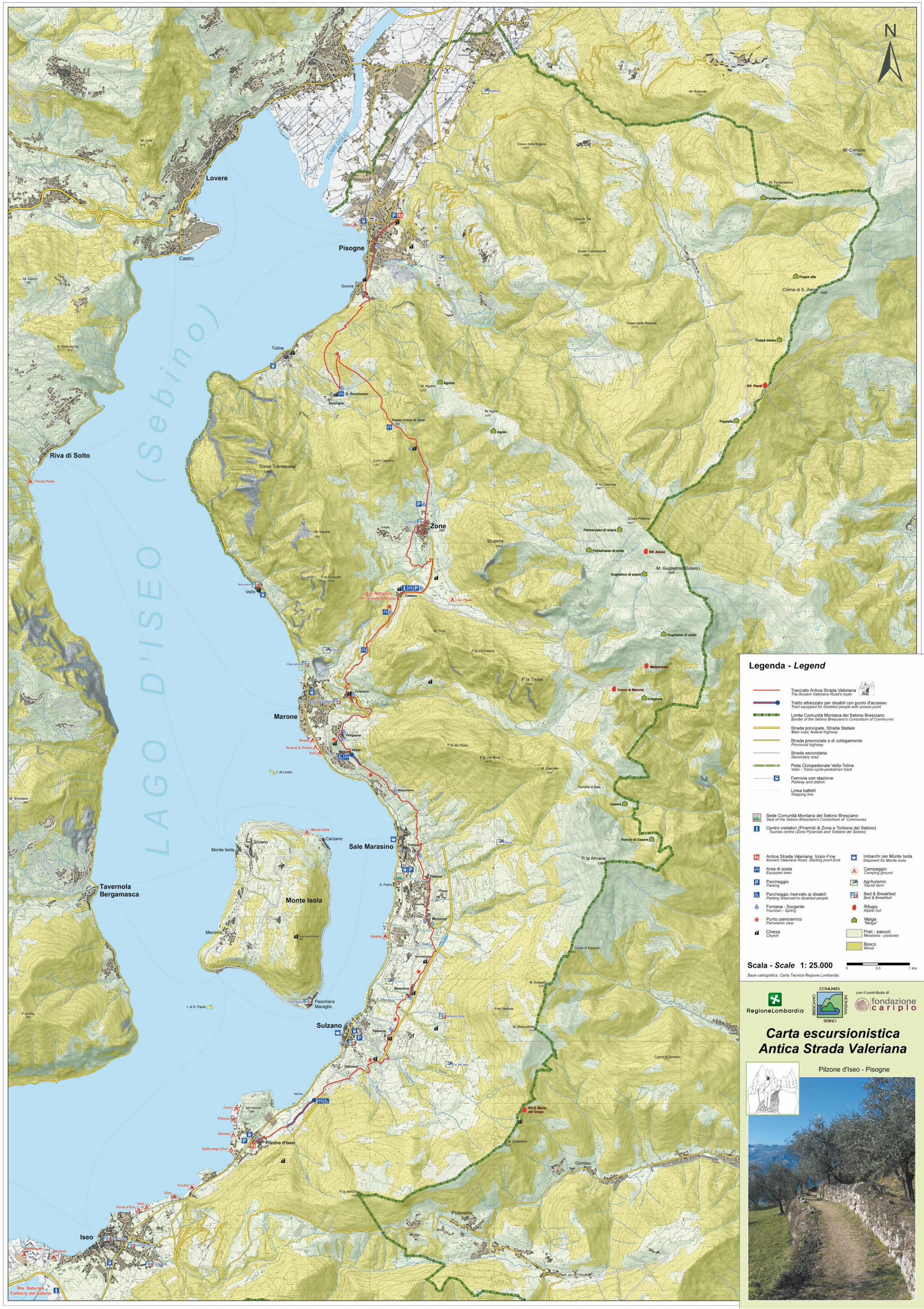
con il contributo di