Regione Umbria TREKKING 23 MISSIANO - Parks.it · Molto belli alcuni piccoli casali ristrutturati...
2
TREKKING 23 MISSIANO - MONTE PETRALVELLA - PANICALE Km: 9,100 - Ore / Duration: 3 00’ - Diff. T - á 396 - â 396 Il punto di partenza della passeggiata è rappresentato dall’area parcheggio del piccolo cimitero di Missiano. Si percorre per un breve tratto la strada provinciale che collega Missiano a Pani- cale e si prende sulla sinistra una strada in terra che sale. Si attraversa un’area ricca di olivi e muretti a secco che si apre sul paesaggio circostante: le colline di Panicale con sullo sfondo Mongiovino e Monte Solare, mentre di fronte appare il borgo stesso, con la sua torre campanaria, i monumenti e le antiche case. Si entra poi nel bosco dove sono presenti la roverella, il cerro, il leccio e l’orniello. Il piano arbustivo risulta costitui- to da ginestra, corbezzolo, cisto, erica, rosa canina e ligustro. Sulla sinistra, salendo, si osserva la vallata del Nestore con Piegaro e Montarale sullo sfondo. Prima di raggiungere la cima del Monte Petrarvella, 627 m., si attraversa un pianoro pano- ramico e si passa vicino a un casale abbandonato situato in posizione dominante. Sulla sinistra si intravedono le antenne del monte Pausillo. Sulla destra il fianco della collina del Pe- trarvella e un altro punto di vista su Panicale e i suoi dintorni. L’area è incolta ed è caratterizzata dalla presenza di una ricca macchia arbustiva composta da rovi, ginestre e prugnoli. Si ar- riva in cima al Petrarvella, riconoscibile per la chioma di pini neri, lungo un sentiero a tornanti che si svolge in una macchia bassa e rada. Dopo una breve sosta si prende a scendere in direzione di Panicale prima lungo un sentiero nella macchia un po’ sconnesso poi per un crinale panoramico con sulla sinistra il lago Trasimeno e sulla destra le colline che guardano verso la valle del Nestore. Molto belli alcuni piccoli casali ristrutturati che si incontrano lungo la via. Si continua la discesa sino a una strada in cemento che in modo deciso ci porta a Panicale. Nell’ultimo tratto si può osservare dall’alto e da vicino il centro storico. Arrivati ai piedi della discesa, si consiglia una passeg- giata all’interno del borgo e lungo il belvedere che costeggia il lato nord delle mura. Seguendo le indicazioni si può tornare in poco tempo al punto di partenza, passando accanto al cimitero e alla chiesa dei Cappuccini, sito storico che avrebbe bisogno di importanti lavori di restauro. The starting point of this itinerary is the parking lot of the lit- tle cemetery of Missiano. Hike over the provincial road which connects Missiano to Panicale for a brief stretch, then take a rising dirt road on the left. You cross an area rich in olives and dry stone walls which opens on the surrounding landscape: the hills of Panicale with Mongiovino and Mount Solare in the background, while in front appears the hamlet itself, with its belfries, monuments and ancient houses. You then enter the woods where downy oak, cedar, holm oak, and manna ash are present. The shrubby plain is made up of broom shrub, straw- berry tree, cistus, heathers, dog roses, and privet. On the left, uphill, you can observe the valley of Nestore with Piegaro and Montarale in the background. Before reaching the top of Mount Petrarvella, 627m., you cross a panoramic plain and pass near an abandoned farmhouse, situated in a dominating position. On the left you can discern the antennas of Mount Pausillo. On the right you can see the slope of Mount Petrarvella and another viewpoint on Panicale and its surroundings. The area is uncul- tivated and characterized by a rich shrubby patch composed of blackberries, broom shrubs and blackthorns. You reach the top of Petrarvella, recognizable for the foliage of black pines, along a hairpin trail which goes through a low and sparse patch. Af- ter a short pause, you start walking downhill in the direction of Panicale, at first along a slightly rough trail among the shrubs, then on a panoramic crest road with the Trasimeno lake on the left and the hills facing the valley of Nestore on the right. The- re are many beautiful, small, renovated farmhouses along the way. You continue downhill until a cement road then takes you decisively to Panicale. In the last stretch you can observe from above and closely the historic center. When you arrive at the foot of the descent, we suggest a walk through the hamlet and along the panoramic road which skirts around the northern side of the walls. Following the signs you can return shortly to the starting point, passing next to the cemetery and the church of the Capuchins, a historic site in need of some important reno- vation works. Regione Umbria Disclaimer Il grafico altimetrico degli itinerari e il suo sviluppo, sono qui presentati in forma sintetica, per facilitarne la comprensione. Per lo sviluppo altimetrico esatto fa fede la traccia GPS scaricabile dal sito. Tanto le tracce gps che i testi e gli stralci di cartografie qui pubblicati sono di proprietà della Regione Umbria. Testi e stralci di cartografie possono essere liberamente riprodotti ed archiviati nel proprio pc nell’ambito di utilizzo personale degli stessi, ed altri utilizzi sono consentiti solo dietro autorizzazione scritta dell’Ente. Le tracce gps sono invece rilasciate con licenza ODbL 1.0 license il cui testo integrale ti preghiamo di consultare prima di utilizzi diversi da quello personale su www.opendatacommons.org/licenses/odbl/1-0/. The following is a simplified altimetry chart, in order to make its reading easier. For more detailed altimetry data the GPS chart can be downloaded from the website. The GPS data, the texts and the map excerpts all belong to Umbria Region; although the texts and the maps may be freely copied and archived in personal computers for private use, any other use is subject to a previous authorization by the regional institution. The GPS data are available through ODbL 1.0 license: it is strongly advised to read the full text of this license before any other-than-private use of the data: www.opendatacommons.org/licenses/odbl/1-0/.
Transcript of Regione Umbria TREKKING 23 MISSIANO - Parks.it · Molto belli alcuni piccoli casali ristrutturati...
TREKKING 23 MISSIANO - MONTE PETRALVELLA - PANICALEKm: 9,100 - Ore / Duration: 3 00’ - Diff. T - á 396 - â 396
Il punto di partenza della passeggiata è rappresentato dall’area parcheggio del piccolo cimitero di Missiano. Si percorre per un breve tratto la strada provinciale che collega Missiano a Pani-cale e si prende sulla sinistra una strada in terra che sale. Si attraversa un’area ricca di olivi e muretti a secco che si apre sul paesaggio circostante: le colline di Panicale con sullo sfondo Mongiovino e Monte Solare, mentre di fronte appare il borgo stesso, con la sua torre campanaria, i monumenti e le antiche case. Si entra poi nel bosco dove sono presenti la roverella, il cerro, il leccio e l’orniello. Il piano arbustivo risulta costitui-to da ginestra, corbezzolo, cisto, erica, rosa canina e ligustro. Sulla sinistra, salendo, si osserva la vallata del Nestore con Piegaro e Montarale sullo sfondo. Prima di raggiungere la cima del Monte Petrarvella, 627 m., si attraversa un pianoro pano-ramico e si passa vicino a un casale abbandonato situato in posizione dominante. Sulla sinistra si intravedono le antenne del monte Pausillo. Sulla destra il fianco della collina del Pe-trarvella e un altro punto di vista su Panicale e i suoi dintorni. L’area è incolta ed è caratterizzata dalla presenza di una ricca macchia arbustiva composta da rovi, ginestre e prugnoli. Si ar-riva in cima al Petrarvella, riconoscibile per la chioma di pini neri, lungo un sentiero a tornanti che si svolge in una macchia bassa e rada. Dopo una breve sosta si prende a scendere in direzione di Panicale prima lungo un sentiero nella macchia un po’ sconnesso poi per un crinale panoramico con sulla sinistra il lago Trasimeno e sulla destra le colline che guardano verso la valle del Nestore. Molto belli alcuni piccoli casali ristrutturati che si incontrano lungo la via. Si continua la discesa sino a una strada in cemento che in modo deciso ci porta a Panicale. Nell’ultimo tratto si può osservare dall’alto e da vicino il centro storico. Arrivati ai piedi della discesa, si consiglia una passeg-giata all’interno del borgo e lungo il belvedere che costeggia il lato nord delle mura. Seguendo le indicazioni si può tornare in poco tempo al punto di partenza, passando accanto al cimitero e alla chiesa dei Cappuccini, sito storico che avrebbe bisogno di importanti lavori di restauro.
The starting point of this itinerary is the parking lot of the lit-tle cemetery of Missiano. Hike over the provincial road which connects Missiano to Panicale for a brief stretch, then take a rising dirt road on the left. You cross an area rich in olives and dry stone walls which opens on the surrounding landscape: the hills of Panicale with Mongiovino and Mount Solare in the background, while in front appears the hamlet itself, with its belfries, monuments and ancient houses. You then enter the woods where downy oak, cedar, holm oak, and manna ash are present. The shrubby plain is made up of broom shrub, straw-berry tree, cistus, heathers, dog roses, and privet. On the left, uphill, you can observe the valley of Nestore with Piegaro and Montarale in the background. Before reaching the top of Mount Petrarvella, 627m., you cross a panoramic plain and pass near an abandoned farmhouse, situated in a dominating position. On the left you can discern the antennas of Mount Pausillo. On the right you can see the slope of Mount Petrarvella and another viewpoint on Panicale and its surroundings. The area is uncul-tivated and characterized by a rich shrubby patch composed of blackberries, broom shrubs and blackthorns. You reach the top of Petrarvella, recognizable for the foliage of black pines, along a hairpin trail which goes through a low and sparse patch. Af-ter a short pause, you start walking downhill in the direction of Panicale, at first along a slightly rough trail among the shrubs, then on a panoramic crest road with the Trasimeno lake on the left and the hills facing the valley of Nestore on the right. The-re are many beautiful, small, renovated farmhouses along the way. You continue downhill until a cement road then takes you decisively to Panicale. In the last stretch you can observe from above and closely the historic center. When you arrive at the foot of the descent, we suggest a walk through the hamlet and along the panoramic road which skirts around the northern side of the walls. Following the signs you can return shortly to the starting point, passing next to the cemetery and the church of the Capuchins, a historic site in need of some important reno-vation works.
Regione Umbria
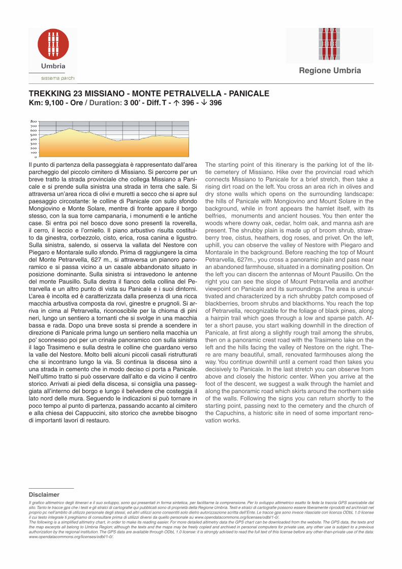
DisclaimerIl grafico altimetrico degli itinerari e il suo sviluppo, sono qui presentati in forma sintetica, per facilitarne la comprensione. Per lo sviluppo altimetrico esatto fa fede la traccia GPS scaricabile dal sito. Tanto le tracce gps che i testi e gli stralci di cartografie qui pubblicati sono di proprietà della Regione Umbria. Testi e stralci di cartografie possono essere liberamente riprodotti ed archiviati nel proprio pc nell’ambito di utilizzo personale degli stessi, ed altri utilizzi sono consentiti solo dietro autorizzazione scritta dell’Ente. Le tracce gps sono invece rilasciate con licenza ODbL 1.0 license il cui testo integrale ti preghiamo di consultare prima di utilizzi diversi da quello personale su www.opendatacommons.org/licenses/odbl/1-0/.The following is a simplified altimetry chart, in order to make its reading easier. For more detailed altimetry data the GPS chart can be downloaded from the website. The GPS data, the texts and the map excerpts all belong to Umbria Region; although the texts and the maps may be freely copied and archived in personal computers for private use, any other use is subject to a previous authorization by the regional institution. The GPS data are available through ODbL 1.0 license: it is strongly advised to read the full text of this license before any other-than-private use of the data: www.opendatacommons.org/licenses/odbl/1-0/.