Pier Franco Pellegrini, Monica Gherardelli, Maurizio Tommasini, Gabriele Poli, Giulia Adembri...
29
Pier Franco Pellegrini, Monica Gherardelli, Maurizio Tommasini, Gabriele Poli, Giulia Adembri Geographic data and metadata coding and network services management for the interoperability of satellite geophysical products on a regional scale The European Association of Remote Sensing Laboratories Satellite Receiving Station of Polo Universitario di Prato (PIN), Italy Electronic & Telecommunication Department (DET) - University of Florence, Italy 27th EARSeL Symposium Geoinformation in Europe June 4-7, 2007 Bozen/Bolzano, Italy
-
Upload
rafe-henry -
Category
Documents
-
view
225 -
download
2
Transcript of Pier Franco Pellegrini, Monica Gherardelli, Maurizio Tommasini, Gabriele Poli, Giulia Adembri...

Pier Franco Pellegrini, Monica Gherardelli, Maurizio Tommasini, Gabriele Poli, Giulia Adembri
Geographic data and metadata coding and network services management for the
interoperability of satellite geophysical products on a regional scale
The European Association of Remote
Sensing Laboratories
Satellite Receiving Station of Polo Universitario di
Prato (PIN), Italy
Electronic & Telecommunication Department (DET) - University of
Florence, Italy
27th EARSeL SymposiumGeoinformation in EuropeJune 4-7, 2007Bozen/Bolzano, Italy

June 4-7, 2007 - Bolzano, Italy
27th EARSeL Symposium - Geoinformation in Europe
2
Satellite Receiving Station of Polo Universitario di Prato (PIN):Direct reception and real-time elaboration of satellite data
http://maresat.ing.unifi.it
Prato, Italy [ 43°53',134 N; 11°05',942 E]
• Direct reception of data from METEOSAT7, MSG, NOAA satellites
• Software developement for real-time processing of satellite data
• Availability of TOVS-ATOVS, SSM/I, MODIS data
• Maintenance and updating of the Receiving Station data archive (satellite data available since 1997)
• Managing of network services for browsing archive products and for data sharing

June 4-7, 2007 - Bolzano, Italy
27th EARSeL Symposium - Geoinformation in Europe
3
Satellite Receiving Station of Polo Universitario di Prato (PIN): Hardware for reception and real-time elaboration of satellite data
METEOSAT7, MSG reception antenna (Ku band)
NOAA satellites reception antenna
Hardware for data acquisition and processing

June 4-7, 2007 - Bolzano, Italy
27th EARSeL Symposium - Geoinformation in Europe
4
Telecommunication Laboratory, University of Florence:Algorithm and procedures developement for data processing
• Continuous environmental monitoring of regional scale zones
• Developement and calibration of algorithms for land/sea geophysical products estimation from satellite data
• Developement of procedures for satellite data analysis and interpretation
http://labtele.det.unifi.it
June 4-7, 2007 - Bolzano, Italy
27th EARSeL Symposium - Geoinformation in Europe
5
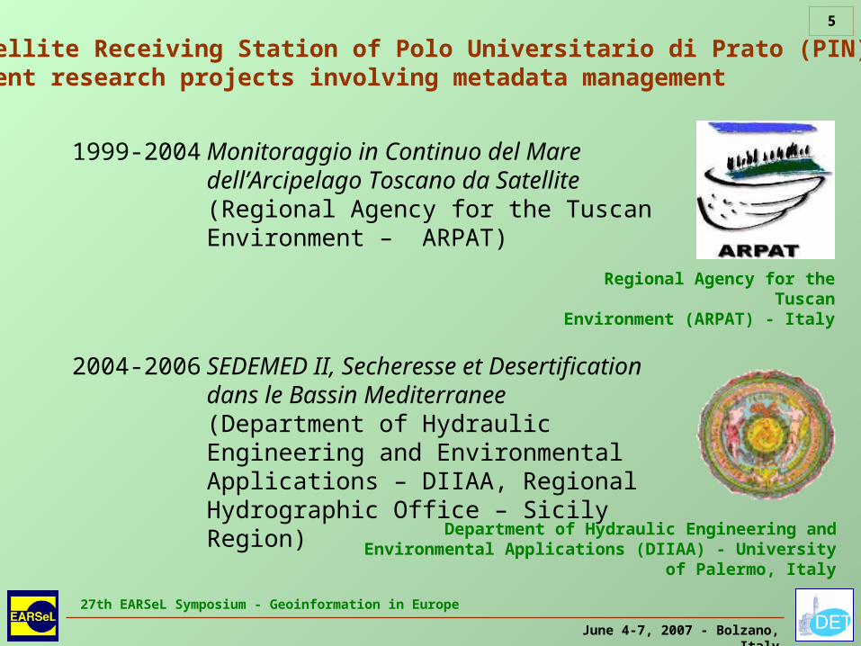
Satellite Receiving Station of Polo Universitario di Prato (PIN):Recent research projects involving metadata management
1999-2004 Monitoraggio in Continuo del Mare dell’Arcipelago Toscano da Satellite (Regional Agency for the Tuscan Environment – ARPAT)
2004-2006 SEDEMED II, Secheresse et Desertification dans le Bassin Mediterranee (Department of Hydraulic Engineering and Environmental Applications – DIIAA, Regional Hydrographic Office – Sicily Region) Department of Hydraulic Engineering and
Environmental Applications (DIIAA) - University of Palermo, Italy
Regional Agency for the Tuscan
Environment (ARPAT) - Italy

June 4-7, 2007 - Bolzano, Italy
27th EARSeL Symposium - Geoinformation in Europe
6
Satellite Receiving Station of Polo Universitario di Prato (PIN):Archive of satellite products – Data Repository
Satellite productAvailable images
Period
Raw data AVHRR-NOAA 33'70013.07.1997 – 31.05.2007
Raw data MVIRI-METEOSAT7
80'250
22.02.2001 – 01.01.200220.12.2003 – 31.12.2006
Raw data SEVIRI-MSG 50'00001.01.2006 – 31.05.2007
Raw data SSM/I-DMSP 5'06001.01.1998 – 31.05.2007
Raw data SeaWiFS-SeaStar 7907.10.1997 – 03.03.1998
Projected LST, NDVI (Sicily)
23001.04.2006 – 30.08.2006
Projected SST (Tuscany) 1'00013.07.1997 – 31.05.2007

June 4-7, 2007 - Bolzano, Italy
27th EARSeL Symposium - Geoinformation in Europe
7
The Standardization approach
International Organization for Standardization (ISO)
Open Geospatial Consortium (OGC)
Geographic Tagged Image File Format (GeoTIFF)
Hierarchical Data Format (HDF)
World Meteorological Organization (WMO)

June 4-7, 2007 - Bolzano, Italy
27th EARSeL Symposium - Geoinformation in Europe
8
Relevant dates for INSPIRE regarding satellite data and metadata
15.05.2007 INSPIRE directive entered into force for Member States
15.05.2009 Member States shall bring into force the laws, regulations and administrative provisions necessary to comply with INSPIRE directive
15.05.2012 Final deadline: adoption of implementing rules also for spatial themes such as: Digital Elevation Models, Land Cover Products, Orthoimagery
02.02.2007 Draft Implementing Rules for Metadata published on the INSPIRE internet site
Infrastructure for Spatial Information in the Community
(INSPIRE)

June 4-7, 2007 - Bolzano, Italy
27th EARSeL Symposium - Geoinformation in Europe
9
• Adaptation of Receiving Station current processing and archiving procedures to international standards
• Estraction and organization of metadata following INSPIRE implementing rules and ISO 19115
• Special focus on quality information following ISO 19115 and 19114
• Developement of network services for browsing data/metadata repository
• Adoption of Extensible Markup Language (XML) for metadata coding following ISO 19139
• Adoption of widely used storage formats for data files like Hierarchical Data Format (HDF) and Geographic Tagged Image File Format (GeoTIFF)
Description of work – Recent research activity of the Receiving Station
June 4-7, 2007 - Bolzano, Italy
27th EARSeL Symposium - Geoinformation in Europe
10
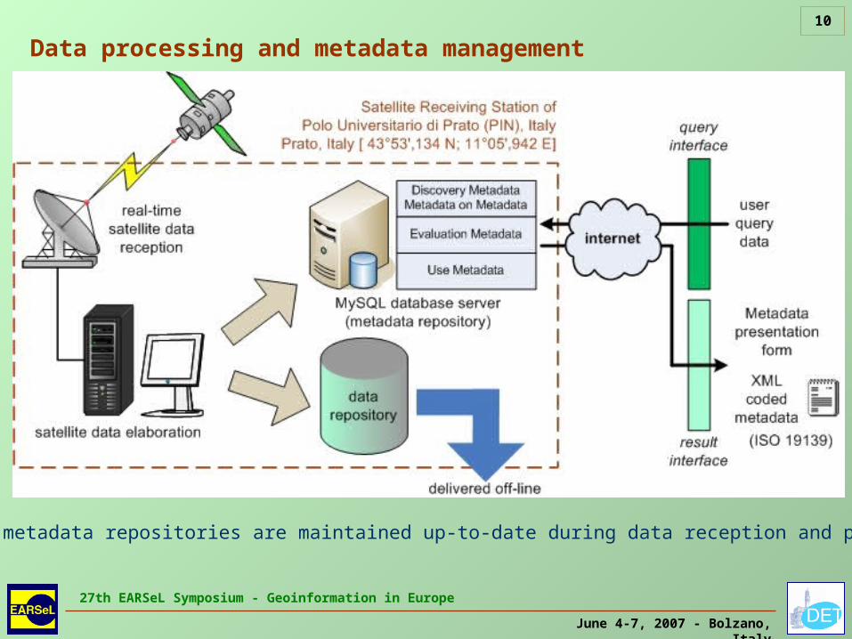
Data processing and metadata management
Data and metadata repositories are maintained up-to-date during data reception and processing

June 4-7, 2007 - Bolzano, Italy
27th EARSeL Symposium - Geoinformation in Europe
11
Characteristics of the geophysical product types
product typeland/sea mask
cloud mask
coastlines, reticulate, palette, other artefacts
storage file format
non-gelocated (only single-pass products)
no no no HDF
geolocated (single-pass and monthly products)
yes
optional (single-pass products); yes (montly products)
noHDF, GeoTIFF
TIFF/JPEG image (single-pass and monthly products)
yes yes yes TIFF, JPEGGeolocated products registered with Mercator WGS84 projection with bilinear or nearest neighbour interpolation
HDF format used for general purpose
GeoTIFF format used especially for geolocated images
TIFF, JPEG formats used only for presentation purpose
Artefacts, land/sea mask based on coastlines available in vectorial form
Cloud mask obtained with threshold algorithms

June 4-7, 2007 - Bolzano, Italy
27th EARSeL Symposium - Geoinformation in Europe
12
Examples of geolocated products (JPEG-TIFF format)
Product title:Land Surface Temperature (LST), Mercator (WGS84) Map of Sicily
Date/time: 16.03.2005, 13:14 UTC
Product type:Geolocated JPEG image registered with nearest neighbour interpolation
Data source: AVHRR/NOAA16
Represent. scale: 1:2'000'000
Temperature palette: 0 – 32°C

June 4-7, 2007 - Bolzano, Italy
27th EARSeL Symposium - Geoinformation in Europe
13
Examples of geolocated products (JPEG-TIFF format)
Product title:Land Surface Temperature (LST), Mercator (WGS84) Map of West Sicily
Date/time: 08.05.2005, 01:41 UTC
Product type:Geolocated JPEG image registered with nearest neighbour interpolation
Data source: AVHRR/NOAA16
Represent. scale: 1:1'000'000
Temperature palette: –8 – 24°C

June 4-7, 2007 - Bolzano, Italy
27th EARSeL Symposium - Geoinformation in Europe
14
Examples of geolocated products (JPEG-TIFF format)
Product title:Monthly average Land Surface Temperature (LST), Mercator (WGS84) Map of Sicily
Date/time: July 2004
Product type:Geolocated JPEG image registered with nearest neighbour interpolation
Data source: AVHRR/NOAA
Represent. scale: 1:2'000'000
Temperature palette: 16 – 48°C

June 4-7, 2007 - Bolzano, Italy
27th EARSeL Symposium - Geoinformation in Europe
15
Examples of geolocated products (JPEG-TIFF format)Product title:
Monthly composite Normalized Difference Vegetation Index (NDVI), Mercator (WGS84) Map of Sicily
Date/time: April 2006
Product type:Geolocated JPEG image registered with nearest neighbour interpolation
Data source: SEVIRI/MSG
Represent. scale: 1:2'000'000
NDVI palette: –0.2 – +0.8

June 4-7, 2007 - Bolzano, Italy
27th EARSeL Symposium - Geoinformation in Europe
16
Examples of geolocated products (JPEG-TIFF format)
Product title:Monthly composite Normalized Difference Vegetation Index (NDVI), Mercator (WGS84) Map of Sicily
Date/time: August 2006
Product type:Geolocated JPEG image registered with nearest neighbour interpolation
Data source: AVHRR/NOAA
Represent. scale: 1:2'000'000
NDVI palette: –0.2 – +0.8

June 4-7, 2007 - Bolzano, Italy
27th EARSeL Symposium - Geoinformation in Europe
17
Experimented tecniques: Bilinear Segmented Interpolation
Sharpening effect along
the coastline in the
interpolated imageProduct title:
Digital counts (ch.3), Mercator (WGS84) Map of Tuscan Archipelago
Date/time: 12.07.1997, 12:58 UTC
Product type:Geolocated JPEG image registered with segmented interpolation
Data source:AVHRR/NOAA12

June 4-7, 2007 - Bolzano, Italy
27th EARSeL Symposium - Geoinformation in Europe
18
Examples of geolocated products (JPEG-TIFF format)
Product title:Sea Surface Temperature (SST), Mercator (WGS84) Map of Tuscan Archipelago
Date/time: 12.05.2002, 12:58 UTC
Product type:Geolocated JPEG image registered with bilinear interpolation
Data source: AVHRR/NOAA16
Represent. scale: 1:1'000'000
Temperature palette: 16 – 32°C

June 4-7, 2007 - Bolzano, Italy
27th EARSeL Symposium - Geoinformation in Europe
19
Examples of geolocated products (JPEG-TIFF format)
Product title:Monthly average Sea Surface Temperature (SST), Mercator (WGS84) Map of Tuscany
Date/time: May 2002
Product type:Geolocated JPEG image registered with nearest neighbour interpolation
Data source: AVHRR/NOAA
Represent. scale: 1:2'000'000
Temperature palette: 6 – 26°C

June 4-7, 2007 - Bolzano, Italy
27th EARSeL Symposium - Geoinformation in Europe
20
Contents of metadata categories in the INSPIRE implementing rules
category of metadata
contents
discovery metadata (level 1 & 2)
the minimum amount of information that needs to be provided to convey to the user the nature and content of the geographic resource
metadata on metadata
information about metadata management, such as metadata point of contact, creation date and language
evaluation metadata
the amount of information sufficient to enable a user to ascertain that a spatial resource fit for a given purpose exists, to evaluate its properties, and to reference some point of contact for more information
use metadata
information required to access, transfer, load, interpret, and apply a spatial resource in the end application where it is exploited (including projection and geometric characteristics, and other parameters that are useful to human and machine in the proper use of spatial resources)
Organization of metadata follows ISO 19115
June 4-7, 2007 - Bolzano, Italy
27th EARSeL Symposium - Geoinformation in Europe
21
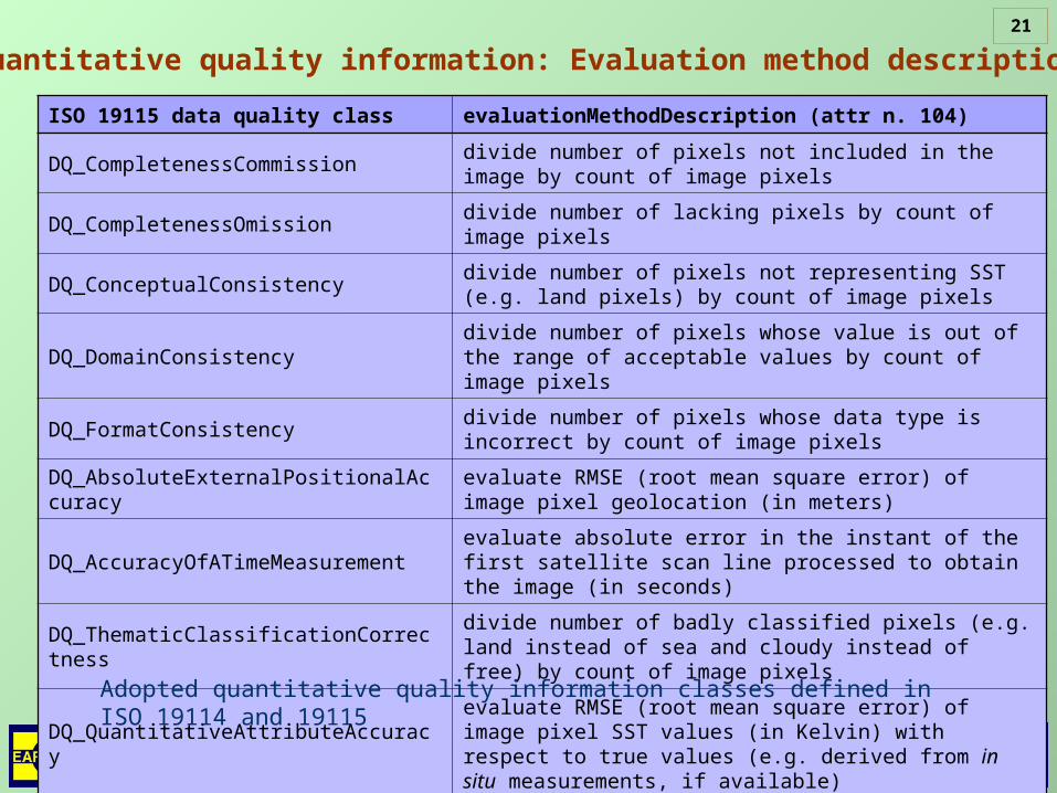
Quantitative quality information: Evaluation method description
ISO 19115 data quality class evaluationMethodDescription (attr n. 104)
DQ_CompletenessCommissiondivide number of pixels not included in the image by count of image pixels
DQ_CompletenessOmissiondivide number of lacking pixels by count of image pixels
DQ_ConceptualConsistencydivide number of pixels not representing SST (e.g. land pixels) by count of image pixels
DQ_DomainConsistencydivide number of pixels whose value is out of the range of acceptable values by count of image pixels
DQ_FormatConsistencydivide number of pixels whose data type is incorrect by count of image pixels
DQ_AbsoluteExternalPositionalAccuracy
evaluate RMSE (root mean square error) of image pixel geolocation (in meters)
DQ_AccuracyOfATimeMeasurementevaluate absolute error in the instant of the first satellite scan line processed to obtain the image (in seconds)
DQ_ThematicClassificationCorrectness
divide number of badly classified pixels (e.g. land instead of sea and cloudy instead of free) by count of image pixels
DQ_QuantitativeAttributeAccuracyevaluate RMSE (root mean square error) of image pixel SST values (in Kelvin) with respect to true values (e.g. derived from in situ measurements, if available)
Adopted quantitative quality information classes defined in ISO 19114 and 19115
June 4-7, 2007 - Bolzano, Italy
27th EARSeL Symposium - Geoinformation in Europe
22
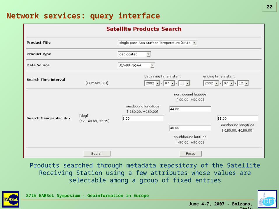
Network services: query interface
Products searched through metadata repository of the Satellite Receiving Station using a few attributes whose values are selectable among a group
of fixed entries

June 4-7, 2007 - Bolzano, Italy
27th EARSeL Symposium - Geoinformation in Europe
23
List of available archive products: for each product the whole metadata set can be viewed in an HTML page or
downloaded as an XML coded text file following ISO 19139
Network services: result interface

June 4-7, 2007 - Bolzano, Italy
27th EARSeL Symposium - Geoinformation in Europe
24
For a selected product, discovery metadata (level 1 & 2), metadata on metadata, evaluation metadata and use metadata can be viewed on an
HTML page
Network services: result interface

June 4-7, 2007 - Bolzano, Italy
27th EARSeL Symposium - Geoinformation in Europe
25
Network services: result interface
Discovery metadata level 2 and metadata on metadata sets viewed on an HTML page

June 4-7, 2007 - Bolzano, Italy
27th EARSeL Symposium - Geoinformation in Europe
26
XML coding examples (ISO 19139)<?xml version="1.0" encoding="UTF-8"?><MD_Metadata xmlns="http://www.isotc211.org/2005/gmd" xmlns:gco="http://www.isotc211.org/2005/gco" xmlns:gts="http://www.isotc211.org/2005/gts" xmlns:gss="http://www.isotc211.org/2005/gss" xmlns:gsr="http://www.isotc211.org/2005/gsr" xmlns:xsi="http://www.w3.org/2001/XMLSchema-instance" xmlns:xlink="http://www.w3.org/1999/xlink" xmlns:gml="http://www.opengis.net/gml"> <!-- Portions of metadata not shown --> <language> <gco:CharacterString>eng</gco:CharacterString> </language> <identificationInfo> <MD_DataIdentification> <citation> <CI_Citation> <title xsi:type="PT_FreeText_PropertyType"> <gco:CharacterString>single-pass SST</gco:CharacterString> <PT_FreeText> <textGroup> <LocalisedCharacterString>single-pass SST</LocalisedCharacterString> </textGroup> </PT_FreeText> </title> </CI_Citation> </citation> </MD_DataIdentification> </identificationInfo> <!-- Portions of metadata not shown --></MD_Metadata>
Instantiation of an MD_Metadata element with MD_DataIdentification element

June 4-7, 2007 - Bolzano, Italy
27th EARSeL Symposium - Geoinformation in Europe
27
XML coding examples (ISO 19139)
Instantiation of an MD_Georectified element
<MD_Georectified> <numberOfDimensions> <gco:Integer>2</gco:Integer> </numberOfDimensions> <axisDimensionProperties> <MD_Dimension> <!-- Portions of metadata not shown --> </MD_Dimension> </axisDimensionProperties> <cellGeometry> <MD_CellGeometryCode codeList="http://www.tc211.org/ISO19139/resources/codeList.xml#MD_CellGeometryCode" codeListValue="point">area</MD_CellGeometryCode> </cellGeometry> <transformationParameterAvailability> <gco:Boolean>true</gco:Boolean> </transformationParameterAvailability> <cornerPoints> <gml:Point srsName="urn:ogc:def:crs:EPSG:6.12:4326"> <gml:pos dimension="2">42.20 9.20</gml:pos> </gml:Point> <gml:Point srsName="urn:ogc:def:crs:EPSG:6.12:4326"> <gml:pos dimension="2">44.50 12.40</gml:pos> </gml:Point> </cornerPoints> <pointInPixel> <MD_PixelOrientationCode>lowerLeft</MD_PixelOrientationCode> </pointInPixel> </MD_Georectified>
June 4-7, 2007 - Bolzano, Italy
27th EARSeL Symposium - Geoinformation in Europe
28
Important Note
MSG data (METEOSAT Second Generation) showed to in this presentation originate from EUMETSAT.
They were obtained through the license issued by Servizio Meteorologico dell’Aeronautica Militare
(Ministero della Difesa conv. N. 4123/62 of 15.11.2005 and Prot. N.M-DGTEL/4123/2508 of 25.01.2007)
Thank you for your attention!

June 4-7, 2007 - Bolzano, Italy
27th EARSeL Symposium - Geoinformation in Europe
29
EU (EUROPEAN UNION) 2007. Directive 2007/2/EC of the European Parliament and of the Council of 14 March 2007, establishing an Infrastructure for Spatial Information in the European Community (INSPIRE). Official Journal of the European Union, L108/1-14, 25 April 2007
HDF (Hierarchical Data Format) Group 2005. HDF5 User’s Guide (Preliminary Version for Release 1.6.5). National Center for Supercomputing Applications (NCSA), University of Illinois at Urbana−Champaign (UIUC), November 2005 (http://hdf.ncsa.uiuc.edu/HDF5/doc/PSandPDF/HDF5_UG_r165pre.pdf)
INSPIRE (Infrastructure for Spatial Information in Europe) – DT Metadata 2007. Draft Implementing Rules for Metadata (D1.3). DT Metadata, 2007 (http://www.ec-gis.org/inspire/reports/ImplementingRules/draftINSPIREMetadataIRv2_20070202.pdf)
ISO (International Standards Organization) 2003a. ISO 19114:2003, Geographic information – Quality evaluation procedures. TC 211 Technical committee “Geographic information/Geomatics”, ISO 2003
ISO (International Standards Organization) 2003b. ISO 19115:2003, Geographic information – Metadata. TC 211 Technical committee “Geographic information/Geomatics”, ISO 2003
ISO (International Standards Organization) 2007. ISO/PRF TS 19139:2007, Geographic information – Metadata, XML schema implementation. TC 211 Technical committee “Geographic information/Geomatics”, ISO 2007
Ritter N. & Ruth M. 2000. GeoTIFF Revision 1.0, Version: 1.8.2. 28 December 2000 (ftp://ftp.remotesensing.org/pub/geotiff/spec/geotiff.rtf.Z)
The Apache Software Foundation, 2005. Xerces-C++ Documentation, Version 2.7.0, 19.09.2005. (http://xml.apache.org/xerces-c/pdf/xerces-c.pdf)
WMO (World Meteorological Organization) 2004. Manual On The Global Telecommunication System, Volume I, Global Aspects, WMO–No. 386, Secretariat of the World Meteorological Organization, Geneva, Switzerland, 2004, ISBN 92-63-12386-14
References