
Performance Assessment of a Commercial GPS Receiver for ...
5
1 Performance Assessment of a Commercial GPS Receiver for Networking Applications Simone Savasta * , IEEE Student Member, Marco Pini † , Gustavo Marfia ‡ * Dipartimento di Elettronica, Politecnico di Torino. Corso Duca degli Abruzzi 24, 10129 Torino, Italy email: [email protected] † Istituto Superiore Mario Boella. Via Pier Carlo Boggio 61,10138 Torino, Italy email: [email protected] ‡ Computer Science Department, University of California Los Angeles, CA 90095, USA email: [email protected] Abstract— Recent years have seen an exponential increase of DVD equipped and navigation assisted cars. Nowadays a car trip can be both entertaining for passengers and computer assisted for drivers. In a further integration of automotive and information technologies, cars will be able to communicate to each other and to the Internet supporting safety, infotainment and pollution prevention applications. The research area which investigates topics, Vehicular Ad hoc NETworks (VANETs), is being widely investigated by both industry and academia. Position information plays a central role in many communication routing schemes designed for VANETs. This trend is justified by the feasibility of algorithms that route packets based on geographical proximity to the destination and by the widespread availability of navigation systems in cars. Geographical information is usually assumed accurate and precise. None of the algorithms available in literature, to the best of our knowledge, take into account possible position estimation errors. This paper is a first step in assessing the precision of a commercial GPS receiver for the support of vehicular com- munications. As we shall see, the performance of the receiver under investigation heavily depends on the type of urban area within this is employed. We believe that a strong understanding of the accuracy of such estimates is important to improve the performance and reliability of a vehicular network infrastructure. Index Terms—GPS, VANET, Vehicular Networks, Ad Hoc Networks, GPSR, Geo-routing I. INTRODUCTION The work presented in this paper derives from an equipment assessment campaign performed for the Campus Vehicular Testbed (CVeT) project [1]. CVeT, a joint UCLA-ISMB project, will be the first campus vehicular testbed available for research. Within this activity, we are analyzing all the factors that can affect the performance and cost effectiveness of a VANET. The wide spread of GPS equipped devices encourages appli- cation and network designers to rely on position information to build more robust and feasible systems. Such trend can also This work is partially supported by the Italian Ministry for Research via the ICTP/E-Grid Initiative and the Interlink Initiative, the Italian Ministry for Foreign Affairs, the National Science Foundation through grants Swarms and Whynet, and the UC-Micro Grant MICRO 04-05 private sponsor STMi- croelectronics. Any opinions, findings, and conclusions or recommendations expressed in this material are those of the author(s) and do not necessarily reflect the views of our sponsors. be found in the design of routing techniques for Mobile Ad hoc NETworks (MANETs). MANETs are auto-configurable networks at first designed for military purposes. Their most popular instantiation, in both the academic and industrial communities, are VANETs. This can be explained by the great expectations upon such type of technology, the safety of streets could greatly benefit by the deployment of a vehicular network which is able to foresee accidents. In brief, in both MANETs and VANETs any node (e.g. computer with a wireless interface) can behave as a host and as a router. A major research challenge in such field is to find algorithms which efficiently route information, under high mobility, between any source-destination pair. A VANET will be probably composed of a MANET, where the information will flow between cars, without the aid of an infrastructure, and of an infrastructure network which cars will use to connect to the Internet. An infrastructure could include, for example, both 3G networks and WiFi hotspots, but also new customized networks which are able to more efficiently interact with the vehicular grid. Many routing strategies which are optimized for VANETs benefit of node position information. A car, say car A, unable to route packets through the infrastructure to car B, can still try to deliver packets through the vehicular grid. If the network graph between car A and car B is connected an intuitive per- hop routing strategy is to forward packets to the closest to destination next hop, given that the position of the destination is known. The family of routing schemes which rely on geographical information are known as Position Based Routing (PBR) strategies. In PBR literature, geographical information is in general assumed to be accurate. This assumption relies on the fact that, in a VANET scenario, GPS systems are typically integrated with map-matching algorithms. In the case the received GPS signal is low or disturbed, a map-matching scheme adjusts a car’s position based on the streets’ topology knowledge. The scope of this paper is to: (a) show the results obtained in two GPS experimental setups, and; (b) briefly comment on these results and indicate some future directions of work. To the best of our knowledge, this is the first work that, based on experimental data, approaches the feasibility of geographical
Transcript of Performance Assessment of a Commercial GPS Receiver for ...
1
Performance Assessment of a Commercial GPSReceiver for Networking Applications
Simone Savasta∗, IEEE Student Member, Marco Pini†, Gustavo Marfia‡∗Dipartimento di Elettronica, Politecnico di Torino. Corso Duca degli Abruzzi 24, 10129 Torino, Italy
email: [email protected]†Istituto Superiore Mario Boella. Via Pier Carlo Boggio 61,10138 Torino, Italy
email: [email protected]‡Computer Science Department, University of California Los Angeles, CA 90095, USA
email: [email protected]
Abstract— Recent years have seen an exponential increase ofDVD equipped and navigation assisted cars. Nowadays a cartrip can be both entertaining for passengers and computerassisted for drivers. In a further integration of automotive andinformation technologies, cars will be able to communicate toeach other and to the Internet supporting safety, infotainmentand pollution prevention applications. The research area whichinvestigates topics, Vehicular Ad hoc NETworks (VANETs), isbeing widely investigated by both industry and academia. Positioninformation plays a central role in many communication routingschemes designed for VANETs. This trend is justified by thefeasibility of algorithms that route packets based on geographicalproximity to the destination and by the widespread availability ofnavigation systems in cars. Geographical information is usuallyassumed accurate and precise. None of the algorithms availablein literature, to the best of our knowledge, take into accountpossible position estimation errors.
This paper is a first step in assessing the precision of acommercial GPS receiver for the support of vehicular com-munications. As we shall see, the performance of the receiverunder investigation heavily depends on the type of urban areawithin this is employed. We believe that a strong understandingof the accuracy of such estimates is important to improve theperformance and reliability of a vehicular network infrastructure.
Index Terms— GPS, VANET, Vehicular Networks, Ad HocNetworks, GPSR, Geo-routing
I. INTRODUCTION
The work presented in this paper derives from an equipmentassessment campaign performed for the Campus VehicularTestbed (CVeT) project [1]. CVeT, a joint UCLA-ISMBproject, will be the first campus vehicular testbed available forresearch. Within this activity, we are analyzing all the factorsthat can affect the performance and cost effectiveness of aVANET.
The wide spread of GPS equipped devices encourages appli-cation and network designers to rely on position informationto build more robust and feasible systems. Such trend can also
This work is partially supported by the Italian Ministry for Research viathe ICTP/E-Grid Initiative and the Interlink Initiative, the Italian Ministryfor Foreign Affairs, the National Science Foundation through grants Swarmsand Whynet, and the UC-Micro Grant MICRO 04-05 private sponsor STMi-croelectronics. Any opinions, findings, and conclusions or recommendationsexpressed in this material are those of the author(s) and do not necessarilyreflect the views of our sponsors.
be found in the design of routing techniques for Mobile Adhoc NETworks (MANETs).
MANETs are auto-configurable networks at first designedfor military purposes. Their most popular instantiation, in boththe academic and industrial communities, are VANETs. Thiscan be explained by the great expectations upon such type oftechnology, the safety of streets could greatly benefit by thedeployment of a vehicular network which is able to foreseeaccidents.
In brief, in both MANETs and VANETs any node (e.g.computer with a wireless interface) can behave as a host andas a router. A major research challenge in such field is tofind algorithms which efficiently route information, under highmobility, between any source-destination pair. A VANET willbe probably composed of a MANET, where the informationwill flow between cars, without the aid of an infrastructure,and of an infrastructure network which cars will use to connectto the Internet. An infrastructure could include, for example,both 3G networks and WiFi hotspots, but also new customizednetworks which are able to more efficiently interact with thevehicular grid.
Many routing strategies which are optimized for VANETsbenefit of node position information. A car, say car A, unableto route packets through the infrastructure to car B, can stilltry to deliver packets through the vehicular grid. If the networkgraph between car A and car B is connected an intuitive per-hop routing strategy is to forward packets to the closest todestination next hop, given that the position of the destinationis known. The family of routing schemes which rely ongeographical information are known as Position Based Routing(PBR) strategies.
In PBR literature, geographical information is in generalassumed to be accurate. This assumption relies on the fact that,in a VANET scenario, GPS systems are typically integratedwith map-matching algorithms. In the case the received GPSsignal is low or disturbed, a map-matching scheme adjusts acar’s position based on the streets’ topology knowledge.
The scope of this paper is to: (a) show the results obtainedin two GPS experimental setups, and; (b) briefly comment onthese results and indicate some future directions of work. Tothe best of our knowledge, this is the first work that, based onexperimental data, approaches the feasibility of geographical

2
routing in a vehicular network from the position precisionstandpoint.
This paper is organized as follows. In Section II overviewgeographical routing approaches in vehicular networks, wethen overview the major error sources for a GPS receiverin Section III. A description of the experiments is given inSection IV. A description of the result’s analysis methodologymay be found in Section V, while the post processing resultsand a discussion on such results in Section VI. We finallyconclude in Section VII.
II. BACKGROUND ON VEHICULAR NETWORKINGSTRATEGIES
A geographic approach to routing in MANETs was firstintroduced in [2]. The protocol proposed in this work, GreedyPerimeter Stateless Routing (GPSR), assumes that a sourceknows its own position and the position of the destination.Packets are then routed, in a completely stateless fashion, fromsource to destination. At each node, say node n, if node n isnot a local minimum (i.e. all node n’s neighbors are not fartheraway from the destination than node n), this will forwardpackets to the closest to destination neighbor. If instead noden is a local minimum, there is no node closest than n to thedestination, node n is a local minimum and there may still bea path leading to the destination. In such situation the protocolenters the perimeter mode. In brief, the perimeter mode is animplementation of the right hand rule and enables a packetto route around a gap which freezes its trip while in greedymode. In order to operate in the perimeter mode, the networkgraph must be first planarized. The planarization of the graphcan be simply thought as the creation of a new graph, withthe same nodes and subset of the links of the original graphsuch that no links cross in the planarized graph.
A number of studies have shown that geographic basedrouting is able to offer significant improvements over topologybased routing protocols such as AODV [3] and DSR [4], forexample. These results have lead to the design of a numberof optimizations and improvements of GPSR [5] [6] [7] andto the design of new geographically-assisted topology-basedrouting protocols [8].
The problem of the uncertainty of position in geographicrouting protocols is first explored in [9]. In such paper theauthors investigate the consequences of an inaccurate position-ing of nodes on GPSR’s planarization algorithm. The authorsintroduce a new landmark-based algorithm that is able, in thepresence of a dense static sensor network, to efficiently routepackets around large gaps in the network’s graph.
III. OVERVIEW OF GPS MEASUREMENTS ANDERROR SOURCES
Since the main objective of this work is to assess theperformance of a low cost Commercial Off-The-Shelf (COTS)GPS receiver in severe urban environments, it is now worthto overview the most important error sources for a singlefrequency GPS receiver.
In the navigation field, the User Equivalent Range Error(UERE) is used to characterize the combined effect of the error
sources on the pseudo-range measurements (i.e.: estimateddistance between the satellite and the receiver), which isfundamental in the user’s position [10]. Roughly speaking,the error sources affecting the pseudo-range estimation can bedue to the Control Segment (i.e. bias of the satellite clock,ephemeris parameters), to the atmospheric propagation (i.e.troposphere and ionosphere effects), to the receiver and tothe antenna’s surrounds (i.e. multipath, thermal noise). TheUERE factor is related to the horizontal positioning errorthrough the Horizontal Dilution Of Precision (HDOP) factor,which depends on the geometry of the satellites in view atthe moment of measurements. The horizontal positioning erroris an important parameter in the evaluation of the receiver’sperformance, and will be further considered in the followingsections. The UERE factor is approximately equal to 6 metersand is obtained under the hypothesis that the error sourcesare uncorrelated. Note that the rounded values reflect theuncertainty in quantifying the actual errors, which stronglydepend on the measurement scenario. As an example, if thereceiving antenna is close to reflecting obstacles (i.e. which islikely the case of urban canyons) the error due to multipathcan be triple in size [10].
Survey grade, multi-frequency receivers, based on carrier-phase measurements are able to further reduce the error onthe pseudo-range measurements and achieve better positioningperformance (UERE rms can be reduced to0.5 m) but withan increased cost of the receiver, which can be up to $10,000.
This work mainly focuses on the performance of a lowcost, code-based, stand alone GPS receiver and on its possibleintegration on an hybrid navcom platform for ad hoc networkapplications. For this preliminary analysis, the main goal ofthe activity is to highlight the receiver’s capabilities in termsof precision. We here consider a single mass-market receiverin different scenarios in order to evaluate how its outputs canaffect VANET requirements. All the tests hereby reported havebeen performed in urban environments.
IV. ON FIELD EXPERIMENTS
We here measure the performance of a low cost COTS GPSreceiver in typical urban environments. The field experimentswere performed in downtown Los Angeles which is a severetest scenario with narrow streets, high buildings shadowingthe GPS satellites’ signals. The receiver’s performance arecompared with the performance obtained, with the samereceiver, in open sky conditions. The same experiments wererepeated on a freeway, with no obstacles in proximity of thereceiving antenna.
The receiver used in the investigation was the HamletHBTGPS20 Bluetooth GPS receiver, which is based on theSirf Star III chipset. Such a chipset is able to track the GPSL1 C/A code and can use up to 20 channels; it is employed inboth autonomous and aided-GPS navigation applications and iswidely used in embedded architectures [11]. An external activepatch antenna was connected to the Hamlet GPS receiverwhich was used to collect a number of data sets througha Bluetooth connection. The National Marine ElectronicsAssociation (NMEA) files at the receiver output were stored

3
and analyzed in post processing. NMEA files [12] record thelatitude, longitude and altitude measured by the receiver aswell as other important parameters (e.g.:(a) the number ofsatellites in view, (b) the HDOP, (c) the elevation of the trackedsatellites, (d) the Carrier-to-Noise power density ratio used innavigation as a strength measure of the received signals).
V. ANALYSIS DESCRIPTION
This section describes the method used to evaluate the erroron position in the collected measurements. In all the testspresented in this paper no inertial sensors have been used inthe experimental setup. The use of inertial sensors would haveled to a complex system, and has not been considered for thisinitial set of experiments.
In order to evaluate the receiver’s positioning performancea reference mark has to be determined. Since the receiver istested along a known path, the idea is to consider the centerof the carriageway as reference. Simplifying the analysis, itis possible to assume that if the estimated error is lowerthan the width of the carriageway, the estimated error can becompletely removed. Thus, the width of the carriageway mayalso be viewed as a confidence interval in which a positionerror can be recovered, for example, through map-matchingtechniques. If instead the difference between the measuredpositions and the reference path is higher than the threshold,we proceed statistically analyzing this error.
For all the collected data sets, the estimated positioning errorhas been obtained by projecting the measured way points ontothe carriageway center. Without the use of inertial sensors, itis not always straightforward to identify the correspondencebetween the measured way-points and the reference path. Inorder to clarify this concept, with the help of Fig. 1, let ushere briefly describe the post processing analysis steps:
• Definition of the reference points. Through an or-thogonal projection, the measured positions (light roundmarkers in Fig. 1) are reported on the reference line (lightsquared markers in Fig. 1).
• Estimation of the positioning error. Once the measuredposition has been reported on the reference path, itis possible to measure its distance with respect to theoriginal way point and indicate such a value as theestimated positioning error (εi).
It must be observed thatεi represents a reliable estimationonly if the true error (which is indicated in Fig. 1 asµi)
1
2
3 4
Reference path
1ε
2ε
3ε
Measured way-point
Real position (unknown) of the receiver on the reference path
iε Estimated positioning error
Car
riage
wid
th
Estimated position of the receiver on the reference path through projection
1μ
iμ Real positioning error
2μ3ε 3μ 4ε 5μ
Error between estimated position and real one on the carriageway center
Measured path
Fig. 1. Difference between the measured way-points and the reference points,when the positioning error is within few meters (εi ≈ µi.)
1
2
3
4
Reference path Car
riage
wid
th
1ε 1μ
2μ 2ε
3ε3μ
4μ4ε
Same legend of Fig. 2
Fig. 2. Difference between the measured way-points and the reference points,in case of significant positioning errors (εi � µi).
assumes small values. In fact, after the first step of thealgorithm, a residual error between the estimated positions onthe reference path (light squared markers in Fig. 1) and the realunknown positions of the receiver at the time of measurements(dark round markers in Fig. 1) still exist. However, ifεi isonly a few meters (thus, within the threshold), the differencebetween the estimated and the real errors is negligible and itis possible to assumeεi ≈ µi .
This is not the case in Fig. 2, which shows the situationcorresponding to an increase in error on the position’s esti-mation. In such case the hypothesis of a negligible differencebetween the estimated and the true position is no longer true.When the position’s estimation error is on the order of tensmeters or more (thus, above the threshold), the absolute valueof εi isn’t significant and doesn’t indicate the true error inposition. In such case, the metric considered to evaluate thereceiver’s performance is the fraction of time, over the wholeset of collected way points, that the difference between themeasured position and the reference path is higher than thethreshold.
VI. POST PROCESSING RESULTS
The performance of a single frequency, stand alone GPSreceiver has been evaluated considering the measured positionsextracted from the NMEA output files. The positioning errorshave been obtained comparing the measured longitude andlatitude to the reference path. The threshold, in meters, used tocompare the difference between the collected way points andthe reference path has been set equal to 20 m. This value isapproximately the freeway’s width. Note that in downtown LosAngeles the carriage-way width might be narrower than thefreeway’s and in such case this threshold value is conservative.
A. Open Sky condition
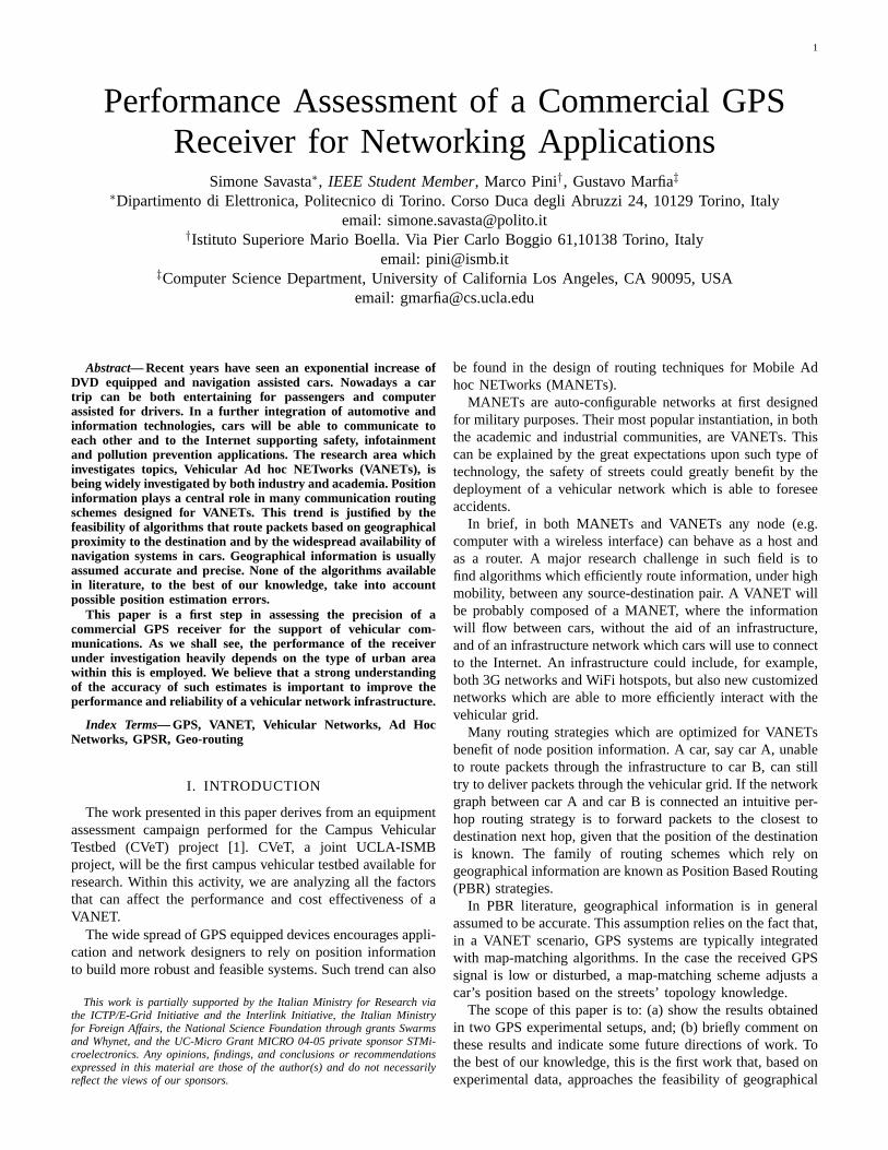
In Fig. 3 we see the travelled path on the Los Angelesfreeway. The red line represents the path estimated by theGPS receiver, while the blue curve represents the center ofthe carriage-way. In this scenario only very small differencesbetween the two paths are visible. Considering the positioningaccuracy reported on the receiver’s manufacturer datasheet (i.e.10 m, assuming open sky condition), the result we observe inFig. 3 clearly shows that the error is within few meters and canbe easily recovered by any simple map-matching algorithm.In Fig. 4 the measured position is plotted as a function ofboth the longitude and latitude. The different colors represent
4
Fig. 3. View of covered path in Los Angeles freeway 10 using a COTSreceiver. Blue curve: ideal covered path. Red curve: real path.
the estimated errorεi with respect to the reference line. Theestimated error values show that the measure is biased (lessthan 20 m). NMEA samples in the output file are periodicand there are no evident discontinuities between the sampledpoints during this measure.
B. Urban Canyon condition
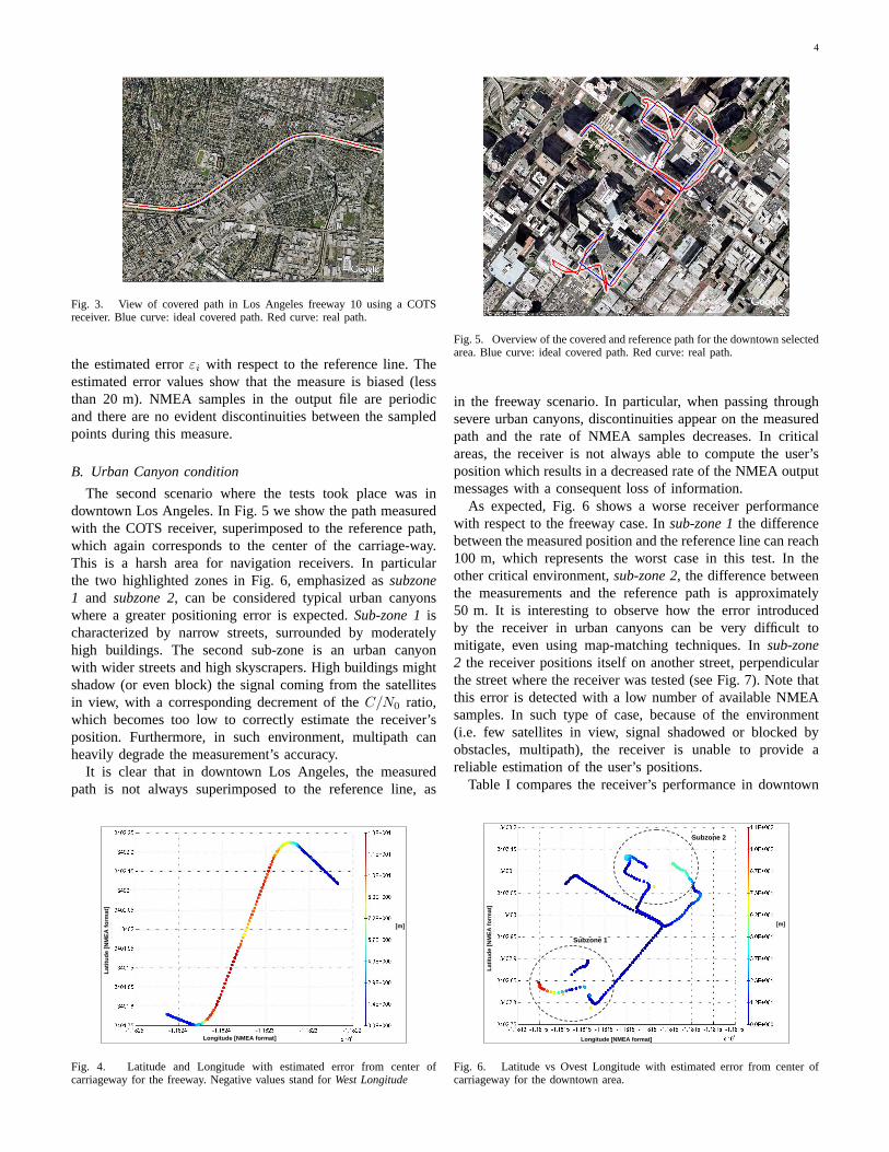
The second scenario where the tests took place was indowntown Los Angeles. In Fig. 5 we show the path measuredwith the COTS receiver, superimposed to the reference path,which again corresponds to the center of the carriage-way.This is a harsh area for navigation receivers. In particularthe two highlighted zones in Fig. 6, emphasized assubzone1 and subzone 2, can be considered typical urban canyonswhere a greater positioning error is expected.Sub-zone 1ischaracterized by narrow streets, surrounded by moderatelyhigh buildings. The second sub-zone is an urban canyonwith wider streets and high skyscrapers. High buildings mightshadow (or even block) the signal coming from the satellitesin view, with a corresponding decrement of theC/N0 ratio,which becomes too low to correctly estimate the receiver’sposition. Furthermore, in such environment, multipath canheavily degrade the measurement’s accuracy.
It is clear that in downtown Los Angeles, the measuredpath is not always superimposed to the reference line, as
[m]
Longitude [NMEA format]
Latit
ude
[NM
EA fo
rmat
]
Fig. 4. Latitude and Longitude with estimated error from center ofcarriageway for the freeway. Negative values stand forWest Longitude
Fig. 5. Overview of the covered and reference path for the downtown selectedarea. Blue curve: ideal covered path. Red curve: real path.
in the freeway scenario. In particular, when passing throughsevere urban canyons, discontinuities appear on the measuredpath and the rate of NMEA samples decreases. In criticalareas, the receiver is not always able to compute the user’sposition which results in a decreased rate of the NMEA outputmessages with a consequent loss of information.
As expected, Fig. 6 shows a worse receiver performancewith respect to the freeway case. Insub-zone 1the differencebetween the measured position and the reference line can reach100 m, which represents the worst case in this test. In theother critical environment,sub-zone 2, the difference betweenthe measurements and the reference path is approximately50 m. It is interesting to observe how the error introducedby the receiver in urban canyons can be very difficult tomitigate, even using map-matching techniques. Insub-zone2 the receiver positions itself on another street, perpendicularthe street where the receiver was tested (see Fig. 7). Note thatthis error is detected with a low number of available NMEAsamples. In such type of case, because of the environment(i.e. few satellites in view, signal shadowed or blocked byobstacles, multipath), the receiver is unable to provide areliable estimation of the user’s positions.
Table I compares the receiver’s performance in downtown
Subzone 1
Subzone 2
[m]
Longitude [NMEA format]
Latit
ude
[NM
EA fo
rmat
]
Fig. 6. Latitude vs Ovest Longitude with estimated error from center ofcarriageway for the downtown area.

5
TABLE I
FRACTION OF ERRORS ON THE CONSIDERED SCENARIOS
Fraction of Collected PositionsRange Error [m] Freeway Downtown
0− 10 63.636% 50.673%10− 20 36.364% 22.642%> 20 0% 26.685%
Number of Snapshots 121 371
Los Angeles with the performance observed on the freeway, asthe fraction of time the difference between the waypoint andthe reference line is higher than the predefined threshold. Themost significative errors are over 20 m, which corresponds tothe assumed threshold. While on a freeway, the estimated errornever exceeds the 20 m threshold, in downtown Los Angelesapproximately27% of the 371 collected measurements areconsidered unreliable, which means that the estimated posi-tioning error was above 20 m.
C. Discussion
The results presented in Subsection VI-C show that inan urban canyon scenario, such as downtown Los Angeles,the commercial GPS receiver under investigation becomesunreliable. Almost one third of the collected estimates showan absolute error that heavily affects the positioning of thereceiver in the urban area. We should especially observe thosecases where the receiver positions the user on a parallel street.We feel that it is important to investigate the impact of suchcases on vehicular networks.
Lets now suppose that a receiver positions a car on theother side of a building. Such mistake might clearly haveconsequences on the navigation system of the car, which mayhave difficulties in leading a driver to his destination. Thismistake may also create problems to a vehicular network.Suppose that, say, car A, positions itself on the wrong side ofa building. Car A will give this information to a geo-locationservice, which will then publish this information to all thosehosts which wish to contact car A. If car B at some pointsends a packet to car A, sending the packet to the address
Positions estimated in opposite directions
Fig. 7. Zoom on the deepest encountered urban canyon. The covered pathis represented by a red line and reference path by a blue line.
erroneously advertised by car A, this packet will get lost onthe other side of the building. The only hope may be thatthe network routing protocol employs Last Encounter Routing(LER) [13] techniques and that some car on the other side ofthe building recently met car A.
From the above example we understand that the equipmentwe use in this paper may be unsuited for the implementationof a VANET based on geo-routing algorithms. In particular,downtown areas of American cities, where urban canyonsare particularly severe, may currently represent an enormousobstacle to an efficient implementation such type of networks.
VII. CONCLUSION
This paper is a first step in understanding the performance ofGPS receivers for VANET applications. In case VANETs willheavily rely on positioning systems, as it is widely believed,we wish to understand how their performance will affect thedelivery of information flows.
As we have seen in this paper, more than locally affectingthe planarization algorithm, as analyzed in [9], a positioningerror can place a car on the other side of a block. Whiletraveling downtown an American city, many packets may belost because of an inaccurate estimation of a car’s position.In a small downtown scenario such as in Los Angeles theimpact of such problem may be limited, but in New York, forexample, we may expect a much worst situation.
The next steps are to better understand the behavior of GPSreceivers in such scenario by: (a) analyzing the performance ofa number of different devices with different chipsets; (b) quan-tify how performance is expected to vary in an urban scenario.Such steps are then necessary to design a vehicular networkgeo-routing strategy that is capable of tolerating positioningerrors without a visible degradation of performance.
REFERENCES
[1] [Online]. Available: http//cvet.cs.ucla.edu/[2] B. Karp and H. T. Kung, “GPSR: greedy perimeter stateless routing for
wireless networks,” inMobile Computing and Networking (MOBICOM),2000, pp. 243–254.
[3] C. Perkins and E. Royer, “Ad-hoc on demand distance vector routing,”in 2nd IEEE Workshop on Mobile Computing Systems and Applications(WMCSA), 1999, pp. 90–100.
[4] D. B. Johnson and D. A. Maltz, “Dynamic source routing in ad hocwireless networks,” inMobile Computing, pp. 153–181.
[5] F. Kuhn, R. Wattenhofer, and A. Zollinger, “Asymptotically optimalgeometric mobile ad-hoc routing,” inProc. of the 6th internationalworkshop on Discrete algorithms and methods for mobile computingand communications (Dial-M). ACM Press, 2002, pp. 24–33.
[6] ——, “Worst-case optimal and average-case efficient geometric ad-hocrouting,” in Proc. of the 4th ACM international symposium on Mobilead hoc networking and computing, 2003, pp. 267–278.
[7] F. Kuhn, R. Wattenhofer, and Y. Zhang, “Geometric ad-hoc routing: oftheory and practice,” inProc. of the twenty-second annual symposiumon Principles of distributed computing, 2003, pp. 63–72.
[8] Y.-B. Ko and N. H. Vaidya, “Location-aided routing(lar) in mobile adhoc networks,”ACM/Baltzer Wireless Networks (WINET) journal, vol.6-7, 2000.
[9] S. Funke and N. Milosavljevic, “Guaranteed-delivery geographic routingunder uncertain node locations,” 2007.
[10] P. Misra and P. Enge,Global Positioning System: Signals, Measurementsand Performance. Ganga Jumuna Press, 2006.
[11] [Online]. Available: www.sirf.com/products/GSD3tProductInsert.pdf[12] [Online]. Available: www.gpsinformation.org/dale/nmea.htm[13] M. Grossglauser and M. Vetterli, “Locating nodes with ease: Last
encounter routing for ad hoc networks through mobility diffusion,” 2003.