DIREZIONE AMMINISTRATIVA AREA RICERCA E ...intra.tesaf.unipd.it/Georisk/DOWNLOAD/Lenzi-R.U. N....
29
DIREZIONE AMMINISTRATIVA AREA RICERCA E TRASFERIMENTO DI TECNOLOGIA SERVIZIO RICERCA Scheda B PROGETTI STRATEGICI –2008 STRATEGIC PROJECTS - 2008 RELAZIONE SCIENTIFICA IN ITINERE MID-TERM SCIENTIFIC REPORT Principal Investigator Prof. Rinaldo Genevois Project Acronym GEORISKS Project Title Geological, morphological and hydrological processes: monitoring, modeling and impact in the North-Eastern Italy Scientific Area 05 Earth Sciences, 40%; 01 MATHEMATICS, 20%; 08 Agricultural Sciences and Veterinary medicine, 20%; 09 Civil Engineering and architecture, 20% Scientific Report of the Research Unit Head of the Research Unit N. 3 Prof. Mario Aristide LENZI 1.Tasks of the period From the approved program, the Research Unit N. 3 (TeSAF Department) is involved in the work- packages 1, 2 and 3. Tasks of the period for this work-packages are the following: WP1-R.U. TeSAF The investigation of the R.U. N. 3, TeSAF Department, in the framework of the work-package WP1, Hillslope dynamics, focuses on the debris flow dynamics in the alpine environment of the Dolomite (Upper Boite river Valley) and on the comparison with other alpine areas. The Dolomite region couples an increasing exploitation in terms of touristic land use with an high vulnerability of roads and villages due to debris flow events which are encouraged by a recruitment of intense rainstorm events. The main scheduled activities are as follows: a) Run-out distance experiments of debris flow mixtures with a small scale physical model; b) Rheological tests by means of a commercial viscosimeter (Brookfield DVII Ultra); c) Dynamics at catchment scale of sediment input causing expected debris-flow volumes.
Transcript of DIREZIONE AMMINISTRATIVA AREA RICERCA E ...intra.tesaf.unipd.it/Georisk/DOWNLOAD/Lenzi-R.U. N....

DIREZIONE AMMINISTRATIVA AREA RICERCA E TRASFERIMENTO DI TECNOLOGIA SERVIZIO RICERCA
Scheda B
PROGETTI STRATEGICI –2008
STRATEGIC PROJECTS - 2008
RELAZIONE SCIENTIFICA IN ITINERE
MID-TERM SCIENTIFIC REPORT
Principal Investigator Prof. Rinaldo Genevois
Project Acronym GEORISKS
Project Title
Geological, morphological and hydrological processes: monitoring, modeling and impact in the North-Eastern Italy
Scientific Area
05 Earth Sciences, 40%; 01 MATHEMATICS, 20%; 08 Agricultural Sciences and Veterinary medicine, 20%; 09 Civil Engineering and architecture, 20%
Scientific Report of the Research Unit
Head of the Research Unit N. 3 Prof. Mario Aristide LENZI
1.Tasks of the period From the approved program, the Research Unit N. 3 (TeSAF Department) is involved in the work-packages 1, 2 and 3. Tasks of the period for this work-packages are the following: WP1-R.U. TeSAF The investigation of the R.U. N. 3, TeSAF Department, in the framework of the work-package WP1, Hillslope dynamics, focuses on the debris flow dynamics in the alpine environment of the Dolomite (Upper Boite river Valley) and on the comparison with other alpine areas. The Dolomite region couples an increasing exploitation in terms of touristic land use with an high vulnerability of roads and villages due to debris flow events which are encouraged by a recruitment of intense rainstorm events. The main scheduled activities are as follows:
a) Run-out distance experiments of debris flow mixtures with a small scale physical model; b) Rheological tests by means of a commercial viscosimeter (Brookfield DVII Ultra); c) Dynamics at catchment scale of sediment input causing expected debris-flow volumes.

DIREZIONE AMMINISTRATIVA SERVIZIO RICERCA
UNIVERSITÀ DEGLI STUDI DI PADOVA
2
WP2-R.U. TeSAF The investigation of the R.U. N. 3, TeSAF Department, in the framework of the work-package WP2, “Hydrological Processes” aims to describe, understand and predict the catchment response in the alpine environment in order to gain information for a better approach to flood mitigation and water management. Experimental activities are conducted in four nested catchments ranging from micro-scale to meso-scale in the upper Cordevole river basin, located in the North-Eastern Italian Dolomites (Belluno Province). An integrated methodological approach, based on field monitoring of the main topographic, geomorphologic and hydrologic variables, the use of environmental, artificial tracers and of geophysical techniques, the application of numerical models will allow to describe surface and subsurface flows, the interaction between surface water and groundwater and, more generally, the main controls governing the catchment runoff response. Specifically, the objectives of WP2-R.U. TeSAF focus on:
a) The analysis of the control exerted by the catchment topography on runoff generation; b) The assessment of the fundamental factors determining the spatial and temporal variability of surface soil moisture patterns and subsurface flow patterns; c) The analysis of the scale-invariant controls on runoff generation at different spatial scales.
WP3-R.U. TeSAF The investigation of the R.U. N. 3, TeSAF Department, in the framework of the work-package WP3, River channel morphology and processes, is aimed to develop and validate integrated experimental and modelling methods that can lead to significant scientific advances on the recent (last 15-20 yr) evolutionary trend and on the likely future dynamics of the Piave river along a 30km-long reach located in the lower part of the mountain basin. Field surveys and field measurements has been taken coupled to analysis of aerial photos and LiDAR data by GIS systems, and a cellular morphological model is being implemented to predict the future evolution of the channel bed and to study the interactions among sediments, wood and islands formation. Incipient motion thresholds and transport distance of sediment clasts and wood elements of different size is being determined for flood events of different magnitudes, and the hydrodynamic and morphological consequences of such transport is being evaluated. The general tasks of WP3-TeSAF are:
a)Analysis and modelling of braider river morphological evolution b) Analysis of the dynamics of sediment, in-channel wood and riparian vegetation in gravel-bed rivers

2.Description of the activities and the 2.1- WP1-R.U. TeSAF; activities and results
a. Runout experiments
The researches proposed several approaches for assessing runout distances (Cannon 1989,Bathurst et al. 1997, Fannin and Wise 2001). Rickenmann (2005) classifies the methods forpredicting the runout distance into empiricaldetailed classification of the approaches in the literature includes volume balance, limitingtopographic methods, other empirical equations, physicallystudies. On July 5th, 2006, an intense rainfall occurred closeNorth-eastern Italy) causing the trigger of seven debris flows. The debris flows started at thecontact of scree slopes with overhanging rock cliffs. Their initiation can be ascribed to acombined erosion caused both by propagated along ephemeral channels incised in scree slopes and expanded on severalcoalescing alpine fans. Detailed field surveys, aerial photographs and LiDAR measurementswere carried out in the triggering and deposition zone. Data analysis deals with morphologicalfeatures of debris-flow deposits and related runout distances. Literature formulas (empiricalstatistical and physically oriented) have been then tested to predict the total travel and the runout distances and to assess their adaptation in the environment of the Dolomites. Inaddition selected samples of the deposited lobes have been used for downscaled laboratorytests on depositional processes (D'Agostino et al., 2010). The experimentconsists of a tilting channel with inclination from 0° to 38° on which a steel box with aremovable gate has been installed. A final horizontal plane serves as deposition area. The testswere performed by installing the tank in different dam breaks phenomena for different debris flow volumes and associated sedimentconcentrations.
DIREZIONE AMMINISTRATIVA SERVIZIO RICERCA
UNIVERSITÀ DEGLI STUDI DI PADOVA
Description of the activities and the obtained scientific results of the period.
; activities and results
The researches proposed several approaches for assessing runout distances (Cannon 1989,Bathurst et al. 1997, Fannin and Wise 2001). Rickenmann (2005) classifies the methods forpredicting the runout distance into empirical-statistical and dynamic methods.detailed classification of the approaches in the literature includes volume balance, limitingtopographic methods, other empirical equations, physically-oriented methods, and laboratory
On July 5th, 2006, an intense rainfall occurred close to Cortina d’Ampezzo (Dolomites,eastern Italy) causing the trigger of seven debris flows. The debris flows started at the
contact of scree slopes with overhanging rock cliffs. Their initiation can be ascribed to acombined erosion caused both by concentrated flow and channel-bed failure. The debris flowspropagated along ephemeral channels incised in scree slopes and expanded on severalcoalescing alpine fans. Detailed field surveys, aerial photographs and LiDAR measurements
e triggering and deposition zone. Data analysis deals with morphologicalflow deposits and related runout distances. Literature formulas and physically oriented) have been then tested to predict the total travel
runout distances and to assess their adaptation in the environment of the Dolomites. Inaddition selected samples of the deposited lobes have been used for downscaled laboratorytests on depositional processes (D'Agostino et al., 2010). The experimentconsists of a tilting channel with inclination from 0° to 38° on which a steel box with aremovable gate has been installed. A final horizontal plane serves as deposition area. The testswere performed by installing the tank in different positions along the channel and simulatingdam breaks phenomena for different debris flow volumes and associated sediment
UNIVERSITÀ DEGLI STUDI DI PADOVA
3
the period.
The researches proposed several approaches for assessing runout distances (Cannon 1989, Bathurst et al. 1997, Fannin and Wise 2001). Rickenmann (2005) classifies the methods for
statistical and dynamic methods. A more detailed classification of the approaches in the literature includes volume balance, limiting
oriented methods, and laboratory
to Cortina d’Ampezzo (Dolomites, eastern Italy) causing the trigger of seven debris flows. The debris flows started at the
contact of scree slopes with overhanging rock cliffs. Their initiation can be ascribed to a bed failure. The debris flows
propagated along ephemeral channels incised in scree slopes and expanded on several coalescing alpine fans. Detailed field surveys, aerial photographs and LiDAR measurements
e triggering and deposition zone. Data analysis deals with morphological flow deposits and related runout distances. Literature formulas and physically oriented) have been then tested to predict the total travel
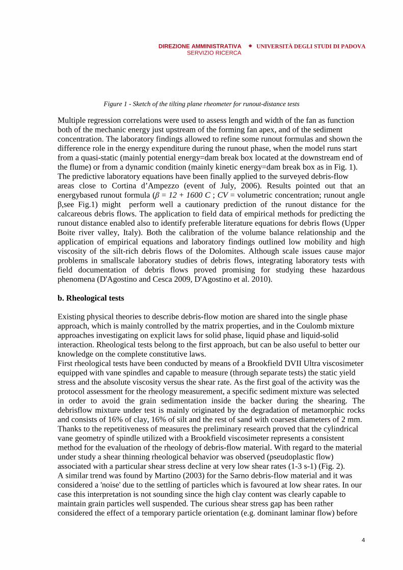
runout distances and to assess their adaptation in the environment of the Dolomites. In addition selected samples of the deposited lobes have been used for downscaled laboratory tests on depositional processes (D'Agostino et al., 2010). The experimental device (Fig.1) consists of a tilting channel with inclination from 0° to 38° on which a steel box with a removable gate has been installed. A final horizontal plane serves as deposition area. The tests
positions along the channel and simulating dam breaks phenomena for different debris flow volumes and associated sediment
DIREZIONE AMMINISTRATIVA SERVIZIO RICERCA
UNIVERSITÀ DEGLI STUDI DI PADOVA
4
Figure 1 - Sketch of the tilting plane rheometer for runout-distance tests Multiple regression correlations were used to assess length and width of the fan as function both of the mechanic energy just upstream of the forming fan apex, and of the sediment concentration. The laboratory findings allowed to refine some runout formulas and shown the difference role in the energy expenditure during the runout phase, when the model runs start from a quasi-static (mainly potential energy=dam break box located at the downstream end of the flume) or from a dynamic condition (mainly kinetic energy=dam break box as in Fig. 1). The predictive laboratory equations have been finally applied to the surveyed debris-flow areas close to Cortina d’Ampezzo (event of July, 2006). Results pointed out that an energybased runout formula (β = 12 + 1600 C ; CV = volumetric concentration; runout angle β,see Fig.1) might perform well a cautionary prediction of the runout distance for the calcareous debris flows. The application to field data of empirical methods for predicting the runout distance enabled also to identify preferable literature equations for debris flows (Upper Boite river valley, Italy). Both the calibration of the volume balance relationship and the application of empirical equations and laboratory findings outlined low mobility and high viscosity of the silt-rich debris flows of the Dolomites. Although scale issues cause major problems in smallscale laboratory studies of debris flows, integrating laboratory tests with field documentation of debris flows proved promising for studying these hazardous phenomena (D'Agostino and Cesca 2009, D'Agostino et al. 2010). b. Rheological tests Existing physical theories to describe debris-flow motion are shared into the single phase approach, which is mainly controlled by the matrix properties, and in the Coulomb mixture approaches investigating on explicit laws for solid phase, liquid phase and liquid-solid interaction. Rheological tests belong to the first approach, but can be also useful to better our knowledge on the complete constitutive laws. First rheological tests have been conducted by means of a Brookfield DVII Ultra viscosimeter equipped with vane spindles and capable to measure (through separate tests) the static yield stress and the absolute viscosity versus the shear rate. As the first goal of the activity was the protocol assessment for the rheology measurement, a specific sediment mixture was selected in order to avoid the grain sedimentation inside the backer during the shearing. The debrisflow mixture under test is mainly originated by the degradation of metamorphic rocks and consists of 16% of clay, 16% of silt and the rest of sand with coarsest diameters of 2 mm. Thanks to the repetitiveness of measures the preliminary research proved that the cylindrical vane geometry of spindle utilized with a Brookfield viscosimeter represents a consistent method for the evaluation of the rheology of debris-flow material. With regard to the material under study a shear thinning rheological behavior was observed (pseudoplastic flow) associated with a particular shear stress decline at very low shear rates (1-3 s-1) (Fig. 2). A similar trend was found by Martino (2003) for the Sarno debris-flow material and it was considered a 'noise' due to the settling of particles which is favoured at low shear rates. In our case this interpretation is not sounding since the high clay content was clearly capable to maintain grain particles well suspended. The curious shear stress gap has been rather considered the effect of a temporary particle orientation (e.g. dominant laminar flow) before

the turbulence prevails. The next step of this activity will be the testing of the Brookfield rheometer for samples takenfrom debris-flow originated by limestone rocks (catchments of the Dolomites) and themerging of this findings with the runout experiment results (tilting plane rheometer, Fig. 1) .
Figure 2 - Rheogramms obtained with the viscosimeter Brookfiled DVIII Ultra c. Estimation of sediment input at basin scale and related debris Magnitude-frequency analysis of debrisand the response from sediment sources areas (D'Agostino 2011) and vice versa the expectedsediment budget from source areas can help in assessing debrisMarchi 2003). Supply unlimited basins, with widespread landslides along the main channeland at the basin head, have quasifrom 0.5-3 events/year (Moscardo torrent, Udine Province, Ital(Marchi and Tecca 2006) to 0.06(Zimmermann et al. 1997a), when material is excavated along the flow path. The researchcarried out by D’Agostino et al. (1996) (Province area of northeastern Italian Alps (Marchi and D’Agostino 2004) is one example of a fruitfulresult. Such investigation took advantage of a careful selection of good quality data andexplored a period (1882-1999) clast century. A predictive equation of volume was obtained by enucleating a powerfulmorpho-energetic variable: Z = catchment area A raised to 1.35 power multiplied by meanchannel slope S raised to 1.7 power. The Z group has confirmed its meaningfulness in afurther investigation (Scheidl and Rickenmann 2010) and in the present (GEORISKS)research (D'Agostino 2010, D'Agostino 2011) (Fig.3).
DIREZIONE AMMINISTRATIVA SERVIZIO RICERCA
UNIVERSITÀ DEGLI STUDI DI PADOVA
The next step of this activity will be the testing of the Brookfield rheometer for samples takenflow originated by limestone rocks (catchments of the Dolomites) and the
ng of this findings with the runout experiment results (tilting plane rheometer, Fig. 1) .
Rheogramms obtained with the viscosimeter Brookfiled DVIII Ultra
c. Estimation of sediment input at basin scale and related debris-flow volumes
frequency analysis of debris-flow volumes provides information about the trendand the response from sediment sources areas (D'Agostino 2011) and vice versa the expectedsediment budget from source areas can help in assessing debris-flow volume (Marchi 2003). Supply unlimited basins, with widespread landslides along the main channeland at the basin head, have quasi-regular debris-flow occurrence, ranging, as an example,
3 events/year (Moscardo torrent, Udine Province, Italy) for highly erosive situations(Marchi and Tecca 2006) to 0.06-0.03 events/year (Leimbach, Canton BE, Switzerland)(Zimmermann et al. 1997a), when material is excavated along the flow path. The researchcarried out by D’Agostino et al. (1996) (Province of Trento) and then extended to the largerarea of northeastern Italian Alps (Marchi and D’Agostino 2004) is one example of a fruitfulresult. Such investigation took advantage of a careful selection of good quality data and
1999) containing the two most severe floods (1882 and 1966) of thelast century. A predictive equation of volume was obtained by enucleating a powerful
energetic variable: Z = catchment area A raised to 1.35 power multiplied by meanto 1.7 power. The Z group has confirmed its meaningfulness in a
further investigation (Scheidl and Rickenmann 2010) and in the present (GEORISKS)research (D'Agostino 2010, D'Agostino 2011) (Fig.3).
UNIVERSITÀ DEGLI STUDI DI PADOVA
5
The next step of this activity will be the testing of the Brookfield rheometer for samples taken flow originated by limestone rocks (catchments of the Dolomites) and the
ng of this findings with the runout experiment results (tilting plane rheometer, Fig. 1) .
Rheogramms obtained with the viscosimeter Brookfiled DVIII Ultra
flow volumes
flow volumes provides information about the trend and the response from sediment sources areas (D'Agostino 2011) and vice versa the expected
flow volume (D'Agostino and Marchi 2003). Supply unlimited basins, with widespread landslides along the main channel
flow occurrence, ranging, as an example, y) for highly erosive situations
0.03 events/year (Leimbach, Canton BE, Switzerland) (Zimmermann et al. 1997a), when material is excavated along the flow path. The research
of Trento) and then extended to the larger area of northeastern Italian Alps (Marchi and D’Agostino 2004) is one example of a fruitful result. Such investigation took advantage of a careful selection of good quality data and
ontaining the two most severe floods (1882 and 1966) of the last century. A predictive equation of volume was obtained by enucleating a powerful
energetic variable: Z = catchment area A raised to 1.35 power multiplied by mean to 1.7 power. The Z group has confirmed its meaningfulness in a
further investigation (Scheidl and Rickenmann 2010) and in the present (GEORISKS)

DIREZIONE AMMINISTRATIVA SERVIZIO RICERCA
UNIVERSITÀ DEGLI STUDI DI PADOVA
6
Figure 3 - Collection of published data on debris-flow volumes: morpho-energetic parameter Z versus deposited volume V. Symbol LS in the legend indicates debris-flow events conditioned by the occurrence of large landslide. The equations in the legend provide debris-flow volumes in cubic meters (D'Agostino 2011, in press). Additional investigations in progress are addressed: i) to highlight the role of historical research in estimation of debris flow volumes (D'Agostino 2011) and their interaction with torrent control works (Marchi et al. 2010); ii) to refine field survey methods estimating the production of sediments which can be removed from active source areas at event scale and thus promoting debris-flow initiation; iii) to assess a method of hazard hierarchization of sediment source areas generating debris flows. On the last topic a multiple-index application has been proposed (D'Agostino and Bertoldi, 2011) joining three key parameters: a susceptibility indicator at sub-catchment scale (Dong et. al. 2009); a triggering indicator at source area scale (adaptation of the slope-area parameter proposed by Zimmerman et al. 1997b); and, finally, a volume budget indicator which was implemented at the hydrographic network scale by computing the expected sediment volumes as a result of possible debrisflow tracks.
2.2- WP2 – R.U. TeSAF; activities and results
Within the scope of WP2, research activities of the TeSAF working unit focus on three main scientific issues, closely investigated by means of the integrated methodological approach. The issues can be summarized in the form of the following research questions. a. In alpine headwater catchments with complex morphological features (steep slopes with shallow soils, relatively flat valley bottoms, thick till deposits and erosion scars), what is the control exerted by the catchment topography (in terms of the main landscape physiographic units) on the runoff generation processes? Particular attention is paid to the distinction between zones within the catchments mainly devoted to storage and release of water, the main processes occurring in the hillslope and riparian zones, the interaction between them, the different activation in wet and dry periods and the response to rainfall or snowmelt inputs. Analyses conducted so far (Penna et al.,
DIREZIONE AMMINISTRATIVA SERVIZIO RICERCA
UNIVERSITÀ DEGLI STUDI DI PADOVA
7
2011) revealed that topography affects the distribution of soil moisture and saturation areas which, in turn, play a significant role in controlling the catchment runoff generation. Particularly, results from field campaigns carried out in the study area highlighted the strong control exerted by soil moisture on runoff, underlined by a sharp threshold in the relationship between soil water content and runoff coefficient, streamflow, and hillslope-averaged depth to water table. Low runoff ratios were likely related to the response of the catchment riparian zone, which was almost always close to saturation. High runoff ratios occurred during wet antecedent conditions, when the soil moisture threshold was exceeded. In these cases, subsurface flow was activated on hillslopes, which became major contributors to runoff. Antecedent wetness conditions were also found to be a main control on the catchment’s response time: during dry periods, streamflow reacted and peaked prior to hillslope soil moisture whereas during wet conditions the opposite occurred. This difference resulted in a hysteretic behaviour in the soil moisture-streamflow relationship. The influence of antecedent moisture conditions on runoff was also evident in the relation between cumulative rainfall and total stormflow. Small storms during dry conditions produced low runoff amounts, likely mainly from overland flow from the near saturated riparian zone. Conversely, for rainfall events during wet conditions, higher runoff values were observed and hillslopes must have contributed to streamflow. Further analysis will be conducted to integrate the suggested conceptual paradigm of catchment functioning in the Dolomitic region. Specifically, tracers will be used for the quantification and specification of the role played by topography on surface and subsurface runoff production. The use of stable water isotopes (2H and 18O) analyzed by means of the recent laser absorption spectroscopy (Penna et al., 2010b), along with geochemical tracers (e.g., electrical conductivity, natural dissolved cations and anions) and artificial tracers (e.g., dyes) will be preferred. Tracers will help to assess the relative contribution of event water (snowmelt or rainfall) and pre-event water (groundwater and soil water) to total stormflow by means of two-component and three-component hydrograph separation techniques, to identify the geographical sources of runoff by means of End Member Mixing Model applications, to quantify the role of snow for groundwater recharge and to compute the water residence time. Preliminary results derived by the analysis of hydrometric, isotopic and geochemical measurements taken during two snowmelt-runoff and six rainfall-runoff events revealed that: i) pre-event water dominates the hydrograph during both snowmelt and rainfall events; ii) the soil moisture conditions prior to the event influence the contribution of “old water”, reflecting the role of riparian zone and hillslope zone on runoff generation during dry and wet conditions, respectively; iii) a rapid displacement of “old water” occur in very wet conditions, leading to a linear relationship between streamflow and tracer concentration during late snowmelt events and intense summer rainstorms. During dry or moderately wet conditions, a hysteretic relationship between streamflow and tracer concentration suggests the delayed contribution of “old water”. b. Which are the main controls on the spatial and temporal variability of surface soil moisture patterns (at different depths) and subsurface flow patterns at the hillslope and catchment scale in alpine environments? Analysis in progress based on observations of water table variations at the small catchment scale are showing that despite the marked topography, a priori grouping of piezometric

DIREZIONE AMMINISTRATIVA SERVIZIO RICERCA
UNIVERSITÀ DEGLI STUDI DI PADOVA
8
response is difficult likely due to the high spatial variability of piezometric response and to the complex microtopography. However, a sharp discrimination among various piezometers is possible on the basis of water table level. Various piezometric groups respond differently to the precipitation forcing according to their relative water table level. Moreover, different temporal water table dynamics are observable in the catchment, with riparian water table variations generally more in phase with surface runoff with respect to piezometers placed far from the stream (Penna et al., 2010a). Future investigations will focus on the influence of initial conditions (i.e., antecedent soil water content and water table level) and to the storm event properties (total precipitation amount, storm duration, intensity etc.) on soil moisture and piezometric response. The investigation of controls on temporal and spatial variability of soil moisture at the hillslope scale (Penna et al., 2009) will be continued analysing the persistence of soil moisture patterns in wet and dry periods. The coupling or decoupling between the spatial patterns of soil moisture and shallow subsurface flow will be investigated along with the interactions between groundwater and surface water and the possible competitive relationship between saturated and unsaturated zone. Moreover, the integration between hydrometric observations and physical hydrological modelling will allow to analyse the processes controlling the non-linear effect in the runoff generation mechanisms (e.g., threshold behaviour in the storage-runoff relationship, hysteretic loops in the streamflow-groundwater relationship). Furthermore, application of particle tracking methods will allow for the computation of advective transport paths, facilitating the visualisation of flow patterns within the catchment. c. Is it possible to use observations conducted in small experimental catchments as indicators of hydrological processes occurring in larger watershed? Within this issue, particular attention is paid to the scale-invariant runoff generation processes, investigated by field observations and physical models, in alpine nested catchments ranging from the micro (< 1-10 km2) to meso-scale (100-1000 km2). Experimental evidence about the potential of small research catchments with detailed data to provide important indications regarding the main processes operating at larger scales is being tested. Comparative observation analyses conducted so far have highlighted the control exerted by soil moisture on runoff at different scales suggesting that few hillslope-scale soil moisture measurements can be used as indicators of the moisture conditions in larger basins (Penna et al., in press). Inter-comparison of event runoff coefficients showed a good correlation across all scales, with runoff coefficient values significantly decreasing with the increase of the catchment area. Runoff coefficients fitted well some theoretical probability distributions but their variability at small scales reflected the marked influence of topography on the catchment runoff response. The application of a physically-based hydrological model to the study basin, compared with two similar experimental catchments in Europe, provided insights both on model reliability and on the catchments’ hydrological behavior (Brocca et al., in press). Particularly, the model performed reasonably well when simulating discharge and soil moisture for the three study areas. The model was able to reproduce a clear threshold-like behaviour existing between wetness conditions and runoff, highlighting the difference in the hydrological response of the three experimental catchments. Based on these preliminary results, further investigations about the functioning of these basins (response time of runoff,

DIREZIONE AMMINISTRATIVA SERVIZIO RICERCA
UNIVERSITÀ DEGLI STUDI DI PADOVA
9
input/output data uncertainty) as well as on the possibility to use soil moisture observations for model calibration and improvements will be conducted. Future investigations will also focus on the controls determining similar or dissimilar hydrological responses at increasing spatial scales and DEM-based analyses will be carried out in order to assess whether the role played by topographic features is different according to the spatial scale taken into account. In this context, the representativeness of microwave remote sensing soil moisture products in comparison with in situ soil moisture measurements will be tested over pilot areas. Additionally, current and future insight deriving from analyses at different scales in alpine environments will provide useful information and dataset for the application of land dynamics modeling (Chang et al., in press) and shallow landslide modeling (Tarolli et al., 2010) as well as for the temporal and spatial quantification of the main flood dynamics (Viglione at al., 2009).
2.3 - WP3 – R.U. TeSAF; activities and results
a. Analysis and modelling of braider river adjustments and evolution In the framework of activities of the first task, a detailed analysis of the timing and extent of the morphological changes that occurred in the last 200 years in the Piave River have been carried out. The Piave River has suffered intense and multiple human impacts, which altered the basin and the river channel (Comiti et al., 2011). Forests have probably reached their minimum extent between the eighteenth and the nineteenth century. Natural (and to a minor extent artificial) reforestation has been taking place since World War I but most effectively after the 1950s because of rapid abandonment of traditional farming and cropping activities on the mountain slopes boosted by the development of industry and tourism. Flows in the Piave River have been regulated for irrigation and hydroelectric power generation over a long period. During the 1930s–1950s, dams were built in many parts of the drainage basin, intercepting sediments from more than 50% of the drainage area. Between the 1960s and 1990s, intense gravel mining was carried out in the main channel and in its main tributaries. Effective erosion and torrent control works started in the upper basin only in the 1930s, but massively only after the 1970s , us recently reported by Conesa-Garcia & Lenzi, 2010, and by Comiti et al., 2011. The study reach is ~30 km long and is located between Ponte nelle Alpi and Busche (Fig.1), with a drainage area at Busche of 3174 km2. The morphology of the river in the study reach is dominated by braided and wandering channel patterns and the slope of the study reach is about 0.45%. Within the study reach, nine subreaches have been delineated based on homogeneity in river corridor width, presence of artificial elements, historical as well as present morphological pattern (Comiti et al., 2011).

DIREZIONE AMMINISTRATIVA SERVIZIO RICERCA
UNIVERSITÀ DEGLI STUDI DI PADOVA
10
Figure 1 - Location and aerial photo of the analyzed reach in the Piave River basin. The location of the nine considered subreaches is also showed. The lateral borders of the subreaches delimit the morphological fluvial corridor, defined by the presence of terraces or geological constraints. Planform changes of river features over the last 200 years were analyzed on three historical maps (1805, 1890, and 1926) and seven aerial photos (1960, 1970, 1982, 1991, 1999, 2003, and 2006). Digital maps and aerial photographs were rectified and coregistered to a common mapping base at 1:5000 by a GIS software. Maps and photos allowed to distinguish the boundaries of a range of fluvial features lying within the fluvial corridor: islands with arboreal vegetation, islands with shrubby vegetation, arboreal marginal vegetation, shrubby marginal vegetation, and herbaceous marginal vegetation. The analysis of the historical maps and aerial photographs shows that substantial changes took place in the Piave River within the investigated time interval (Fig.2). The extension of the unvegetated active channel was at its highest at the end of nineteenth century. The active channel area reduced in two different stages. A first phase of adjustment took place during the first half of the twentieth century and was characterized by a loss of about 35% of the initial active channel area. This trend was interrupted by the high magnitude/low frequency flood event that occurred in 1966 that determined an abrupt channel enlargement. The subsequent narrowing phase was more intense, and in the following period (1991–2003), a reversal occurred with an evident sharp widening tendency that extended the active channel at a rate of 27 ha/year (9 m/year). Complementary to the trends in the active channel, the proportion of the fluvial corridor covered by vegetation at the channel margins has experienced a significant change over the period 1805–2006, being at its lower extent at the end of nineteenth century and afterwards extending until 1991 (Fig.2). Islands were present in the study reach since the early 1800s, but their overall extension was always much smaller than marginal vegetation. During the narrowing phase (1970–1991), the proportion of island area within the river corridor increased only slightly, as opposed to the remarkable expansion of surfaces covered in marginal vegetation. The channel expansion stage that occurred between 1991 and 2003 shows a similar reduction in island relative extension, reaching a final value similar to 1970 (Fig.2).

DIREZIONE AMMINISTRATIVA SERVIZIO RICERCA
UNIVERSITÀ DEGLI STUDI DI PADOVA
11
Figure 2 - Proportion of the fluvial corridor occupied by the unvegetated active channel, marginal vegetation, and islands throughout the last two centuries. Flood events that exhibited relevant effects in terms of channel adjustments are marked. As to the vertical evolution (incision/aggradation) within the study reach, the Figure 3 shows the variation of mean cross section elevations taking as a reference the most recent value, i.e., either the 2007 DGPS survey or the 2003 LiDAR-derived DTM (Comiti et al., 2011). As to the long-term bed changes, bed elevation in 1929 was about 1 m higher than present days; but the difference is >2.5 m at the very upstream limit of the reach, and it is negligible just upstream of the confluence with the Cordevole (cross section distance of 19 km). The recent bed level adjustment trends (i.e., after 1985) appear rather more complex. The 1966 flood events determined an abrupt channel expansion and most likely caused a moderate aggradation in the study reach. Looking at the recent bed adjustments, most cross sections show 1990s bed elevation quite similar to present levels, estimating that an overall error of up to ±0.3–0.4 m could occur when comparing surveys of different sources and methods. Results from geomorphological surveys (Comiti et al., 2011) are in good agreement with those from cross section comparisons (one to three surveys were carried out for each sub-reach). The analyzed reach of the Piave River was characterized by remarkably wider extensions of its active channel area during the nineteenth century and this evidence can be taken as representative of conditions of unregulated basins in terms of hydrology and sediment transport. However, this wider active channel may also reflect a higher human pressure on basin land use because at that time the forest cover was at its historical minimum and sediment supply from the basin was likely at its maximum (Comiti et al., 2011). During the twentieth century, two phases of channel narrowing were identified in the study reach as in other Italian rivers (Surian et al., 2009). The channel narrowing that occurred during the first half of the 1900s was caused by an array of factors such as river training structures (i.e., the perpendicular groynes built in the 1940s, likely the dominant factors in the associated sub-reaches) and land use variation at catchment scale (i.e., increase in forest cover on slopes). The second phase of narrowing was relatively short (approximately from 1970 to 1990) but very intense and associated with channel degradation. In this case gravel mining is the main driver of incision and narrowing during this phase, and vegetation encroachment is a consequence of incision. This confirms the key role of sediment mining in Italian rivers

DIREZIONE AMMINISTRATIVA SERVIZIO RICERCA
UNIVERSITÀ DEGLI STUDI DI PADOVA
12
(Surian et al., 2009). As to the recent channel adjustments, even tough a general channel widening is apparent in the study reach between the 1990s and 2006, no clear indications of a widespread, concomitant aggradation phase are observed, confirming that widening is taking place without any aggradation in some reaches.
Figure 3 - Variation of average bed elevation as derived from the comparison of cross sections (Table 3) along the longitudinal distance of the study reach. Each cross section is plotted according to its distance from the upstream reach limit (Ponte nelle Alpi). Positive values indicate XS where the streambed at that time (i.e., 1929, 1985, 1991, or 1996) was higher than at present (i.e., where incision took place) and negative values the opposite. The dashed lines indicate the error that is associated with data comparison (±0.4 m). Overall, the results from the planimetric and vertical adjustments of the Piave River reveal In order to explore and better define the recent evolutionary trend along the study reach, two LiDAR and photogrammetric flights have been commissioned and realized in 2010 and 2011. These new aerial photographs are currently being rectified and coregistered (along with the 2009 flight photos) to a common mapping base by a GIS software. LiDAR will be filtered using a dedicated software in order to remove the vegetation cover and then will be used to assess precisely the erosion/deposition areas within the study reach as a response to flood events. b.Analysis of the dynamics of sediment, in-channel wood and riparian vegetation in gravel-bed rivers Sediment transport monitoring and assessment differs substantially from mountain alpine torrents were intensive bed load and debris flows can occur (Lenzi et al., 2011; Comiti & Mao, 2010, in press) to wide gravel-bed rivers characteristics of low-land environments. In wide gravel-bed rivers, the transport of sediments is very difficult to measure accurately with bed-load traps or samplers because of the high heterogeneity of sediment sizes and complex channel topography (i.e., different morphological units). This is especially true during flood events, when most of the bed load transport occurs. To overcome these issues, in this study an indirect approach, known as morphological methods, have been used. It consists of back-calculation of bed material transport volumes from the dimensions of the active bed layer and

DIREZIONE AMMINISTRATIVA SERVIZIO RICERCA
UNIVERSITÀ DEGLI STUDI DI PADOVA
13
the displacement of individual clasts. Painted grains have been used to assess the morphological effects of flows on different units, and to obtain the travelled distances of grains of different sizes. For the depth of the active sediment layer, scour chains have been used (Mao et al, 2011b). The assessment have been carried out in six cross sections, which have been measured in two selected sub-reaches (Fig.4).
Figure 4 - Location of the 6 cross-sections selected for studyng sediment transport dynamics, large wood abundance and vegetation characteristics. Morphology of the active channel along each cross section was classified into one of the following units: main channel (MC), secondary channel (SC), low bar (LB), high bar (HB), and island (I). The field recognition of those units was based on a combination of elevation, bed material, and vegetation cover criteria. Along the three cross sections surveyed, a number of sites (28 overall) were selected as representatives of each morphological units. At those sites, GPS position and vertical digital photographs of the bed surface were taken. The collected photos were processed with a dedicated software to derive the surface grain size distribution of each site. After the photographs were taken, the surface of the same photographed area was painted using a fast-drying spray paint. All the painted areas were visited immediately after each flood event during the study period. All the painted particles moved by the floods and found in the downstream direction were collected. Their size and the travelled distance from the centre of the painted site were measured using a caliper and a tape, respectively. Seven different classes of effects of flows on the painted areas were recognized (Fig.5). A further technique involving the use of passive transponders has been used to assess the incipient motion and the displacement distance of marked clasts. Over 400 passive integrated transponders (PIT) have been inserted in natural pebble and then tracked by hand-held antennas after low to moderate flood (Fig.6). To estimate the shear stress acting on the flooded sites, at each visit the maximum flow depth over each painted area was estimated from field evidence such as lines of organic debris and fine sediments on higher morphological units. For the assessment of the active sediment layer, 25 scour chains have been inserted along the 6 cross sections (Fig.7). The insertion technique allows installing chains of 1 m length without disturbing the packing of the bed material. Galvanised iron chains with a 2 cm link length have been used. Cross sectional surveys before and after each flow event allowed further

DIREZIONE AMMINISTRATIVA SERVIZIO RICERCA
UNIVERSITÀ DEGLI STUDI DI PADOVA
14
determination of the active width by delineating the portion of the bed with a significant post-event elevation change.
Figure 5 - Classification of the effects of floods over the painted areas.
. Figure 6 - Passive integrated transponders (on the left) have been inserted into natural pebbles and than tracked after flood events using a portable antenna (on the right).

Figure 7 - The use of scour chains for the assessment of active sediment thickness. The whole range of acquired data (displacement distances, active layer thickness, shear stresses) is being used to assess the bedload transport occurred during single flood events using an indirect morphological method as preliminary reported in Mao et al.evidences of surface grains packing and structure have been collected in the field using a Terrestrial Laser Scanner and will be used to assess the degree of armouring, infer sediment mobility and bed roughness and provide critical insightsedimentation processes as recently suggested by Mao et al. (2011). As to the assessment of wood presence in the Piave River, all wood pieces greater than 10 cm in diameter and 1m in length (as done in previous works) lyithe 6 selected cross sections were measured. The volume of each wood element was calculated from its mid-diameter and length, assuming a solid cylindrical shape, as commonly done in LW studies (Rigon et al., 2010)measured with a tape and a tree caliper, respectively. Additional data concerning tree species, orientation to flow, state of decay, delivery mechanism and position in the channel were collected for each piece (Figat least two elements) were measured and classified relatively to their main function in the jam: key members (i.e. anchoring other logs) and nonmembers, boulders or bank obstructions). Each wood jams was classified following Abbe and Montgomery (2003). They defined three types of LW jams depending on the origin of their elements: autochthonous (key wood elements not fluvially transported, thus coming frobank or floodplain in the close proximity of the jam position), allochthonous or transport (i.e. key elements coming from the banks) and combination jams (autochthonous key elements with racked transported pieces). Overall, 46 jams and 271 isolated analysis of their characteristics, degree of organization, morphological effects, dynamics and volumes is undergoing. The possibility of using Terrestrian Laser Scanner instruments and methodologies for LW field measurements and evaluations is under study (Picco et al., 2011)
DIREZIONE AMMINISTRATIVA SERVIZIO RICERCA
UNIVERSITÀ DEGLI STUDI DI PADOVA
The use of scour chains for the assessment of active sediment thickness.
The whole range of acquired data (displacement distances, active layer thickness, shear stresses) is being used to assess the bedload transport occurred during single flood events using an indirect morphological method as preliminary reported in Mao et al.evidences of surface grains packing and structure have been collected in the field using a Terrestrial Laser Scanner and will be used to assess the degree of armouring, infer sediment mobility and bed roughness and provide critical insight on the sediment availability and sedimentation processes as recently suggested by Mao et al. (2011). As to the assessment of wood presence in the Piave River, all wood pieces greater than 10 cm in diameter and 1m in length (as done in previous works) lying within a buffer of 300 m along the 6 selected cross sections were measured. The volume of each wood element was
diameter and length, assuming a solid cylindrical shape, as commonly (Rigon et al., 2010). The length and mid-diameter of each element were
measured with a tape and a tree caliper, respectively. Additional data concerning tree species, orientation to flow, state of decay, delivery mechanism and position in the channel were collected for each piece (Fig.8). All visible pieces composing log jams (i.e. accumulations of at least two elements) were measured and classified relatively to their main function in the jam: key members (i.e. anchoring other logs) and non-key members (i.e. lodged against key
, boulders or bank obstructions). Each wood jams was classified following Abbe and Montgomery (2003). They defined three types of LW jams depending on the origin of their elements: autochthonous (key wood elements not fluvially transported, thus coming frobank or floodplain in the close proximity of the jam position), allochthonous or transport (i.e. key elements coming from the banks) and combination jams (autochthonous key elements with racked transported pieces). Overall, 46 jams and 271 isolated logs have been identified and measured in the field. The analysis of their characteristics, degree of organization, morphological effects, dynamics and
The possibility of using Terrestrian Laser Scanner instruments and for LW field measurements and evaluations is under study (Picco et al., 2011)
UNIVERSITÀ DEGLI STUDI DI PADOVA
15
The use of scour chains for the assessment of active sediment thickness.
The whole range of acquired data (displacement distances, active layer thickness, shear stresses) is being used to assess the bedload transport occurred during single flood events using an indirect morphological method as preliminary reported in Mao et al. (2011). Further evidences of surface grains packing and structure have been collected in the field using a Terrestrial Laser Scanner and will be used to assess the degree of armouring, infer sediment
on the sediment availability and
As to the assessment of wood presence in the Piave River, all wood pieces greater than 10 cm ng within a buffer of 300 m along
the 6 selected cross sections were measured. The volume of each wood element was diameter and length, assuming a solid cylindrical shape, as commonly
diameter of each element were measured with a tape and a tree caliper, respectively. Additional data concerning tree species, orientation to flow, state of decay, delivery mechanism and position in the channel were
). All visible pieces composing log jams (i.e. accumulations of at least two elements) were measured and classified relatively to their main function in the
key members (i.e. lodged against key , boulders or bank obstructions). Each wood jams was classified following Abbe and
Montgomery (2003). They defined three types of LW jams depending on the origin of their elements: autochthonous (key wood elements not fluvially transported, thus coming from the bank or floodplain in the close proximity of the jam position), allochthonous or transport (i.e. key elements coming from the banks) and combination jams (autochthonous key elements
logs have been identified and measured in the field. The analysis of their characteristics, degree of organization, morphological effects, dynamics and
The possibility of using Terrestrian Laser Scanner instruments and for LW field measurements and evaluations is under study (Picco et al., 2011).

Figure 8 - The field form used to survey wood pieces lying on the channel. Regarding the riparian vegetation pattern, distribution and size in the Piave River, the relationship between the vegetation structure and the morphological characteristics of two sub-reaches have been analyzed. Six crossvariables were measured in vegetation and soil properties have been measured: canopy cover (%) and plant community; diameter, height, canopy size, species of each tree; number of herbaceous species; thickness of fine layer and grain size distribuwere recognized on a recent aerial photo and its ages were calculated performing a multitemporal analysis of older photos.
DIREZIONE AMMINISTRATIVA SERVIZIO RICERCA
UNIVERSITÀ DEGLI STUDI DI PADOVA
The field form used to survey wood pieces lying on the channel.
Regarding the riparian vegetation pattern, distribution and size in the Piave River, the ip between the vegetation structure and the morphological characteristics of two
reaches have been analyzed. Six cross-sections were surveyed, and vegetation and soil variables were measured in 4x4 m plots, 10m spaced (Fig.9). In these selected plots, vegetation and soil properties have been measured: canopy cover (%) and plant community; diameter, height, canopy size, species of each tree; number of herbaceous species; thickness of fine layer and grain size distribution of coarse sediments (Fig.9). Also, each vegetation plot were recognized on a recent aerial photo and its ages were calculated performing a multitemporal analysis of older photos.
UNIVERSITÀ DEGLI STUDI DI PADOVA
16
The field form used to survey wood pieces lying on the channel.
Regarding the riparian vegetation pattern, distribution and size in the Piave River, the ip between the vegetation structure and the morphological characteristics of two
sections were surveyed, and vegetation and soil ). In these selected plots, various
vegetation and soil properties have been measured: canopy cover (%) and plant community; diameter, height, canopy size, species of each tree; number of herbaceous species; thickness
). Also, each vegetation plot were recognized on a recent aerial photo and its ages were calculated performing a multi-

Figure 9 - Representation of vegetation and soil properties along three cross sections reach. A preliminary analysis reveals that communities typical of both highly dynamic (active and high bars) and stable (floodplains) units lie on surfaces with different age but at relatively similar elevation. Interestingly, areas dominated by different species. Overall, the Piave River shows a complex pattern of vegetation distribution along the crosselevation and the plant communities (Vitti et al., 2011). However, later successional plant communities cover older surfaces, and the sand layer thickness helps discriminate communities with different ecological needs. Islands are mainly generated from pioneering vegetated areas within the active channel width, and persists for less than 20 years (similarly to what found in the Tagliamento River, Zanoni et al., 2008). A recent tendency of active channel widening after a long period of channel narrowing (1970s“mature” patches lie at elevations similar to areas covered with the most pioneer plant communities.
DIREZIONE AMMINISTRATIVA SERVIZIO RICERCA
UNIVERSITÀ DEGLI STUDI DI PADOVA
Representation of vegetation and soil properties along three cross sections
A preliminary analysis reveals that communities typical of both highly dynamic (active and high bars) and stable (floodplains) units lie on surfaces with different age but at relatively similar elevation. Interestingly, the thickness of the sand layer helps explaining differences in areas dominated by different species. Overall, the Piave River shows a complex pattern of vegetation distribution along the cross-sections, with no clear relationship between the
the plant communities (Vitti et al., 2011). However, later successional plant communities cover older surfaces, and the sand layer thickness helps discriminate communities with different ecological needs. Islands are mainly generated from pioneering
ated areas within the active channel width, and persists for less than 20 years (similarly to what found in the Tagliamento River, Zanoni et al., 2008). A recent tendency of active channel widening after a long period of channel narrowing (1970s-1990s) may“mature” patches lie at elevations similar to areas covered with the most pioneer plant
UNIVERSITÀ DEGLI STUDI DI PADOVA
17
Representation of vegetation and soil properties along three cross sections located in the Belluno sub-
A preliminary analysis reveals that communities typical of both highly dynamic (active and high bars) and stable (floodplains) units lie on surfaces with different age but at relatively
the thickness of the sand layer helps explaining differences in areas dominated by different species. Overall, the Piave River shows a complex pattern of
sections, with no clear relationship between the the plant communities (Vitti et al., 2011). However, later successional plant
communities cover older surfaces, and the sand layer thickness helps discriminate communities with different ecological needs. Islands are mainly generated from pioneering
ated areas within the active channel width, and persists for less than 20 years (similarly to what found in the Tagliamento River, Zanoni et al., 2008). A recent tendency of active
1990s) may explain why “mature” patches lie at elevations similar to areas covered with the most pioneer plant
DIREZIONE AMMINISTRATIVA SERVIZIO RICERCA
UNIVERSITÀ DEGLI STUDI DI PADOVA
18
2.4 Additional cited references
Bathurst J.C., Burton A., Ward T.J. (1997). Debris flow run-out and landslide sediment delivery model tests. Journal of Hydraulic Engineering 123: 410-419. Cannon S.H. (1989). An approach for estimating debris flow run-out distances. Proc. Conference XX International Erosion Control Association, Vancouver: 457-468. D’Agostino V., Marchi L. (2003). Geomorphological estimation of debris-flow volumes in alpine basins. In D. Rickenmann, & C. L. Chen (Eds.), Third Int. Conference on Debris-Flows Hazards Mitigation: Mechanics, Prediction and Assessment, vol. 2, Rotterdam, Netherlands, Millpress: 1097–1106. Dong J. J., Lee C. T., Tung Y. H., Liu C. N., Lin K. P., Lee J.F. (2009). The role of sediment budget in understanding debris flow susceptibility. Earth Surface Processes and Landforms 34: 1612 -1624. Fannin R.J., Wise M.P. (2001). An empirical-statistical model for debris flow travel distance. Canadian Geotechnical Journal 38: 982-994. Marchi L., Tecca P.R. (2006) Some observations and the use of data from historical documents in debris-flow studies. Natural Hazards 38: 301-320. Martino R. (2003). Experimental analysis on the rheological properties of a debris-flow deposit. In D. Rickenmann, & C. L. Chen (Eds.), Third Int. Conference on Debris-Flows Hazards Mitigation: Mechanics, Prediction and Assessment, vol. 1, Rotterdam, Netherlands, Millpress: 363–373. Rickenmann D. (2005). Runout prediction methods. In: Jakob, M., Hungr, O. (eds) Debris- Flow Hazards and Related Phenomena. Praxis, Chichester: 305-324. Zimmermann M, Mani P, Romang H. (1997a) Magnitude-frequency aspects of alpine debris flows. Eclogae Geologicae Helvetiae 90: 415-420. Zimmermann M., Mani P., Gamma P. (1997b). Murganggefahr und Klimaanderung – ein GIS basierter Ansatz. Schlusbericht NFP 31, Vdf Hochschulvertag AG ETH Zurich.
2.5 Plans and programs for integrating the research activity with high level training of young researchers
Training of young researchers was carried out by the TeSAF-Department in the framework of the activities of the PhD Research School “L.E.R.H: Land, Environment, Resources and Health”-curricula Water Resources and Watersheds Management (Scuola di Dottorato di Ricerca “Territorio, Ambiente, Risorse e Salute”-curicula Idronomia Ambientale). From the
DIREZIONE AMMINISTRATIVA SERVIZIO RICERCA
UNIVERSITÀ DEGLI STUDI DI PADOVA
19
beginnig of the project the following PhD Students were including in the research staff and oriented to the activities of GEORISKS:
WP1: • Francesco Bettella (from 01-01-2010 to 31-12-2012); • Gabriele Bertoldi (from 01-01-2012 to 31-12-2013); • Enrico Pozza (from 01-01-2011 to 31-12-2013). WP2: • Alberto Gobbi (from 01-11-2009 to 31-12-2011); • Nicola Mantese (from 01-01-2010 to 31-12-2012); • Davide Zoccatelli (from 01-01-2010 to 31-12-2012). WP3: • Marco DaCanal (from 01-11-2009 to 31-12-2010); • Gabriel Kaless (from 01-01-2009 to 31-12-2011); • Johnny Moretto (from 01-01-2011 to 31-12-2013).
Recruitment of other young researchers were done during years 2010 and 2011, and complete the TeSAF research team:
a)Scholarships for Post-MSc degree (WP3, Paolo Vitti, from 01-07-2010 to 31-08-2011 and Bruno Garniga, from 01-04-2011 to 31-12-2011); b) Post-Doc positions (WP3, Luca Mao, from 01-05-2010 to 31-12-2010 and WP1, Daniele Penna, from 01-01-2011 to 31-12-2011).
Different training activities were planning and organized (during 2010 and 2011) in the framework of the formative activities of the PhD Research School L.E.R.H, curricula Water Resources and Watershed Management, like the following:
a) five (5) Specific PhD Courses of 25 hours (GIS Open Sources, LiDAR, GPS and Terrestrial Laser Scanner, MatLab and Geostatistic); b) two (2) International Workshop; the Research Unit N. 3, TeSAF Department and the PhD Research School “Land, Environment, Resources and Health”, have organized on 1st September 2010 an International Workshop entitled “River morphology, sediment transport and vegetation dynamics”. Prof. Murray Hicks (N.I.W.A, New Zealand) participated as a special guest to the workshop and than spent one day in the field with the WP3 working group. In a following International Workshop entitled “Hydraulic, sediment transport and morphological evolution of gravel-bed rivers” and hold at the TeSAF Department on 25th March 2011, Prof. James Cooper (University of Sheffield, UK) participated with a speech especially focused on roughness and shear stress on gravel-bed

DIREZIONE AMMINISTRATIVA SERVIZIO RICERCA
UNIVERSITÀ DEGLI STUDI DI PADOVA
20
rivers. Prof. James Cooper than participated to an intensive period of field surveys in few north-eastern gravel-bed rivers, including the Piave;
At the beginning of the Georisks Project (2009-2010), young researchers (particularly involved on WP2 activities) took advantages from the UNIPD-TeSAF and L.E.R.H PhD School participation at the EU Research Project and NETWORK "HYDRATE: Hydrometeorological data sources and technologies for effective flash flood forecasting", coordinated by Prof. Marco BORGA, with the participation of 17 university and international research centers of Europe, USA, ASIA and LA. In the framework of the strategic project, international research fellows have been involved for collaboration within WP1 activities. Virginia Ruíz Villanueva (PhD student), from the Spanish Geological Institute (Madrid), works on the following topics: analysis of flood hazard; analysis of triggering conditions of hyperconcentrated flows; spatial-temporal reconstructions of past geomorphic activity; wood anatomical analyses on trees injured by geomorphological processes; geostatistical analysis of rainfall data. Efthimios Nikolopoulos (post-doc), from the Hellenic Centre for Marine Research (Anavyssos Attiki, Greece) works on flash flood analysis and modeling in mountain catchments (Nikolopoulos et al., 2011). From 2010, WP1 and WP3 young researchers benefits also from the training activities coming from the participation of the PhD Research School L.E.R.H. in the International EU Network Erasmus Mundus Joint Doctoral Programma FONASO “Forest and Nature for Society”. Future mobility or TeSAF-PhD students and young researchers are also possible in the framework of the following Joint PhD Collaborations Agreement of the PhD Research School L.E.R.H, with: a) the Universidad Politecnica di Madrid, Spain (PhD “Ingenieria Forestal); b) the Universidad Austral de Valdivia, Chile (PhD “Ciencias Forestales”); c) the Universidad de Cuyo, Mendoza, Argentina (PhD “Agronomia”)
2.6 Other training and dissemination
In order to integrate high level training and research activities, TeSAF young researchers (staff and recruitment) participated also at the following International and National Conferences, Workshops and Meetings:
a) 7th Gravel-Bed Rivers Conference-2010; Tadoussac, Québec, Canada, 6-10 September 2010; b) European Geophysical Union General Assembly, 2-7 May 2010 and 3-8 April 2011; c) Euromediterranean Network of experimental and Representative Basins, 13th Biennial Conference ERB 2010 on Hydrological Response of Small Basins to a changing environment; d) European Cooperation Network COST FP0601 FORMAN: Forest Management and the Water Cycle; e) National Conference on “Making safe the mountain land, Florence, Italy, 11 November 2010, Italian Academy of Forest Sciences; f) International Workshop “Advances in River Sciences”, Swansea, UK, 18-21 April 2011.
In the framework of the International scientific community, the Department TeSAF (Land and Agro-forest Environment) will participate at the “5Th International Conference on Debris

DIREZIONE AMMINISTRATIVA SERVIZIO RICERCA
UNIVERSITÀ DEGLI STUDI DI PADOVA
21
Flow Hazard Mitigation: Mechanics, Predictions and Assessment, to be held in Padova, 14-17 June, 2011. At the Conference, some results obtained within the WP1-TeSAF research activities will be presented. In the framework of the National scientific community, the R.U n. 3 will participate at the Workshop “Pericolosità idraulica nel territorio montano italiano ed applicazione della Direttiva Europea “Alluvioni”, 2007/60/CE”. The Workshop is organized by the Free University of Bolzano and the Autonomous Province of Trento (“Ripartizione Opere Idrauliche”). Prof. M.A. Lenzi will participated with a speech especially focused on “Solid transport and bed load monitoring in mountain rivers”, while Prof. M. Borga and Prof. V. D’Agostino will give key-notes, respectively, on “Hydrological modeling of floods in mountain basins” and “Dynamics and quantification of debris flood and debris flows in mountain rivers”. Some preliminary outcomes from the GEORISKS Project will be presented and addressed to helping local authorities and technicians in the elaboration of Hydraulic Hazard and Risk Management Plain, “Moderni piani di gestione del rischio idraulico” as suggested by the European Directive 2007/60/CE.
3.List of publications and scientific products of the period 3.1 Referred publications, ISI Journals
WP1 D’Agostino V., Cesca M., Marchi L. (2010). Field and laboratory investigation of run-out distances of debris flow in the Dolomites (Eastern Italian Alps)”, Geomorphology, 115: 294-304. Marchi L., Cavalli M., D’Agostino (2010). Hydro-geomorphic processes and torrent control works on a large alluvial fan in the eastern Italian Alps. Natural Hazards and Earth System Sciences, 10: 547-558. WP2 CHANG, K-T., A. VELDKAMP, M. BORGA, 2011: Modeling Land Dynamics in mountainous environments: Preface. Geomorphology, submitted. NIKOLOPOULOS, E.I., E.N. ANAGNOSTOU, M. BORGA, E.R. VIVONI and A. PAPADOPOULOS, 2011: Sensitivity of a mountain basin flash flood to initial wetness conditions and rainfall variability. J. of Hydrology,doi:10.1016/j.jhydrol.2010.12.020.

DIREZIONE AMMINISTRATIVA SERVIZIO RICERCA
UNIVERSITÀ DEGLI STUDI DI PADOVA
22
PENNA, D., M. BORGA., D. NORBIATO, G. DALLA FONTANA, 2009: Hillslope scale soil moisture variability in a steep alpine terrain. Journal of Hydrology, 364, 311-327, doi:10.1016/j.jhydrol.2008.11.009. PENNA, D., M. BORGA, M. SANGATI and A. GOBBI, 2010a: Dynamics of soil moisture, subsurface flow and runoff in a small alpine basin. Status and perspectives of Hydrology in Small Basins (Proceedings of the Workshop held at Goslar-Hahnenklee, Germany, 30 March–2 April 2009). IAHS Publ. 336, 2010, 96-102. PENNA, D., B. STENNI, M. ŠANDA, S. WREDE, T.A. BOGAARD, A. GOBBI, M. BORGA, B.M.C. FISCHER, M. BONAZZA and Z. CHÁROVÁ, 2010b: On the reproducibility and repeatability of laser absorption spectroscopy measurements for δ
2H and δ
18O isotopic analysis. Hydrol. Earth Syst. Sci., 14, 1551–1566, doi:10.5194/hess-14-1551-2010. PENNA, D., H.J. TROMP-VAN MEERVELD, A. GOBBI, M. BORGA, G. DALLA FONTANA, 2011: The influence of soil moisture on threshold runoff generation processes in an alpine headwater catchment. Hydrol. Earth Syst. Sci. 15, 689-702, 2011, doi:10.5194/hess-15-689-2011. TAROLLI, P., M. BORGA, KANG-TSUNG CHANG, SHOU-HAO CHIANG, 2010: Modelling shallow landslide susceptibility by incorporating heavy rainfall statistical properties. Geomorphoplogy, in press. VIGLIONE, A., G.B. CHIRICO, J. KOMMA, R. WOODS, M. BORGA and G. BLÖSCHL, 2009: Quantifying space-time dynamics of flood event types. J. of Hydrology, 394 (1–2), 213–229.doi:10.1016/j.jhydrol.2010.05.041 WP3 COMITI F., DA CANAL M., SURIAN N., MAO L., PICCO L., LENZI M. A. (2011). Channel adjustments and vegetation cover dynamics in a large gravel bed river over the last 200 years. GEOMORPHOLOGY, vol. 125; p. 147-159, ISSN: 0169-555X. MAO L., J.R. COOPER, L. E. FROSTICK (2011). Grain size and topographical differences between static and mobile armour layers; EARTH SURFACE PROCESSES AND LANDFORMS; DOI: 10.1002/esp. 2156 SURIAN N., ZILIANI L., COMITI F., LENZI M. A., MAO L. (2009). Channel adjustments and alterations of sediment fluxes in gravel-bed rivers of north-eastern Italy: potentials and limitations for channel recovery. RIVER RESEARCH AND APPLICATIONS, vol. 25; p. 551-567, ISSN: 1535-1459, doi: 10.1002/rra.1231

DIREZIONE AMMINISTRATIVA SERVIZIO RICERCA
UNIVERSITÀ DEGLI STUDI DI PADOVA
23
3.2 Chapter of books and Books WP1 D’Agostino V. (2010) Chapter 9: Filtering-retention check dam design in mountain torrents. In: Garcia C.C., Lenzi M.A. (eds) Check Dams, Morphological Adjustments and Erosion Control in Torrential Streams, Nova Science Publishers, Hauppage, New York: 185-210. D'Agostino V. (2011) Assessment of past torrential events through historical sources. In Bollschweiler M, Stoffel M., Rudolf-Miklau F. (eds) Tracking Torrential Processes on Fans and Cones, Springer, Chichester, UK (in press). WP2 PENNA D., MANTESE N., GOBBI A. and BORGA M.: Runoff response at different spatial scales: moving from small experimental areas to meso-scale catchments. In: H. Holzmann, R. Godina, G. Muller (Ed.), Hydrological Responses of Small Basins to a Changing Environment, IHP-VI, Technical Documents in Hydrology, UNESCO, Paris, in press. BROCCA L., MELONE F., PENNA D., MORAMARCO T., PENNA D., MATGEN P., HEITZ S.: Investigation of the hydrologic response of three experimental basins across Europe. In: H. Holzmann, R. Godina, G. Muller (Ed.), Hydrological Responses of Small Basins to a Changing Environment, IHP-VI, Technical Documents in Hydrology, UNESCO, Paris, in press. WP3 COMITI F., LENZI M. A., MAO L., (2010). Chapter 12: Local Scouring at Check-Dams in Mountain Rivers. In: CONESA GARCIA C. , LENZI M. A. (Editors). Check Dams, Morphological Adjustments and Erosion Control in Torrential Streams; pp. 263-282, NEW YORK-Nova Science Publishers, Inc., ISBN/ISSN: 978-1-60876-146-3 COMITI F., MAO L., (in press). Recent advances on the dynamics of steep channels. Proceedings of the 7th Gravel Bed Rivers Conference – 2010; Tadoussac; Québec, Canada; 6-10 September 2010; PP. 54. CONESA-GARCIA C, M. A. LENZI (Editors). (2010). Check Dams, Morphological Adjustments and Erosion Control in Torrential Streams. NEW YORK: Nova Science Publishers, Inc., pp. 1-339, ISBN: 978-1-60876-146-3.

DIREZIONE AMMINISTRATIVA SERVIZIO RICERCA
UNIVERSITÀ DEGLI STUDI DI PADOVA
24
3.3 Proceedings, Extended Abstracts, Abstract, Poster and Oral Presentations WP1 D'Agostino V., Bertoldi G. (2011) Hazard hierarchization of debris flow sediment source areas. Geophysical Research Abstracts, Vol. 13, EGU2011-12557, 2011 General Assembly 2011. D'Agostino V. (2010). Technical and scientific evolution of integrated strategies of protection against torrential phoenomena. Conference on ‘Making safe the mountain land’, Florence, Italy, 11 November 2010, Italian Academy of Forest Sciences: invited presentation. WP2 GOBBI A., PENNA D., MANTESE N., BORGA M., 2011. Analysis of catchment response to rainfall and snowmelt by means of isotopic, geochemical and hydrometric data. Geophysical Research Abstracts, vol. 13, EGU2011-7868, European Geosciences Union, General Assembly 2011 - Vienna, Austria, 03 – 08 April 2011. MANTESE N., PENNA D., GOBBI A., BORGA M., 2011. Spatial and temporal variability of piezometric response at the small catchment scale. Geophysical Research Abstracts, vol. 13, EGU2011-11824-1, European Geosciences Union, General Assembly 2011 - Vienna, Austria, 03 – 08 April 2011. ARONICA G.T., TAROLLI P., PENNA D., BORGA M., 2011. Analysis of shallow landsliding friggere by estreme precipitation: the October 1, 2009 event in Giampilieri (Sicily). Geophysical Research Abstracts, vol. 13, EGU2011-4293-1, European Geosciences Union, General Assembly 2011 - Vienna, Austria, 03 – 08 April 2011. MARRA F., ZANON F., PENNA D., MANTESE N., ZOCCATELLI D., CAVALLI M., MARCHI L., 2011. Hydrometeorological and hydrological analysis for the Nov. 1, 2010 flood event in North-Eastern Italy. Geophysical Research Abstracts, vol. 13, EGU2011-10727-1, European Geosciences Union, General Assembly 2011 - Vienna, Austria, 03 – 08 April 2011. PENNA D., MANTESE N., GOBBI A., BORGA M., 2010. What can we learn from small experimental catchments? An upscaling case in the Italian Dolomites. “Euromediterranean Network of Experimental and Representative Basins. 13th Biennial Conference ERB 2010 on Hydrological Responses of Small Basins to a changing environment.” Seggau Castle, Austria - 5-8 September 2010. BROCCA L., MELONE F., MORAMARCO T., PENNA D., BORGA M., MATGEN P., HEITZ S., 2010. Rainfall-runoff modelling for three experimental basins across Europe. “Euromediterranean Network of Experimental and Representative Basins. 13th Biennial
DIREZIONE AMMINISTRATIVA SERVIZIO RICERCA
UNIVERSITÀ DEGLI STUDI DI PADOVA
25
Conference ERB 2010 on Hydrological Responses of Small Basins to a changing environment.” Seggau Castle, Austria - 5-8 September 2010. PENNA D., MANTESE N., GOBBI A., 2010. Spatio-temporal variability of subsurface flow patterns in a first-order alpine catchment. EGU Leonardo Topical Conference Series on the Hydrological Cycle 2010: “Looking at Catchments in Colors: Debating new ways of generating and filtering information in hydrology.” Luxembourg, 10-12 November 2010. ARONICA G., TAROLLI P., PENNA D., BORGA M., 2010. Analysis of shallow landsliding and debris flows triggered by extreme precipitation: the October 1, 2009 event in Giampilieri (Sicily). Vol. 12, Plinius12-99, 12th Plinius Conference on Mediterranean Storms, Corfu Island Greece, September 2010. PENNA D., TROMP VAN-MEERVELD H.J., GOBBI A., BORGA M., 2010. Non-linearity of runoff generation processes in an alpine headwater catchment. Geophysical Research Abstracts, vol. 12, EGU2010-13437-1, European Geosciences Union, General Assembly 2010 - Vienna, Austria, 02 – 07 May 2010. PENNA D., GOBBI A., MANTESE N., BORGA M., 2010. Topographical controls on soil moisture distribution and runoff response in a first order alpine catchment. Geophysical Research Abstracts, vol. 12, EGU2010-13463, European Geosciences Union, General Assembly 2010 - Vienna, Austria, 02 – 07 May 2010. BROCCA L., PENNA D., MELONE F., MORAMARCO T., GOBBI A., 2010. Use of soil moisture and water table data for rainfall-runoff modelling in alpine catchments. Geophysical Research Abstracts, vol. 12, EGU2010-4973, European Geosciences Union, General Assembly 2010 - Vienna, Austria, 02 – 07 May 2010. TAROLLI P., ZOCCATELLI D., PENNA D., BORGA M., 2010. Spatial moments of catchment rainfall and their use to quantify the influence of spatial rainfall variability on runoff response. Geophysical Research Abstracts, vol. 12, EGU2010-14173, European Geosciences Union, General Assembly 2010 - Vienna, Austria, 02 – 07 May 2010. WP3 Picco L., Vitti P., Mao L., Ravazzolo D., Rigon E., Moretto J. & Lenzi M.A., 2011. Large Woody Debris measurements in a gravel bed braided river environment using Terrestrial Laser Scanner: the Piave River study case. EGU General Assembly, Vienna 2011; Geophysical Research Abstracts, Vol. 13, EGU 2011-1551-1 . Mao L., Surian N., Comiti F., Picco L., Rigon E. & Lenzi M.A., 2011. Evaluation of the event based sediment transport in a wide gravel-bed river using tracers and scour chains. Advances in River Science, 18-21 April 2011, Swansea, UK.
DIREZIONE AMMINISTRATIVA SERVIZIO RICERCA
UNIVERSITÀ DEGLI STUDI DI PADOVA
26
Vitti P., Picco L., Mao L., Sitzia T., Comiti F., Rigon E. & Lenzi M.A., 2011. Linking riparian forest structure and fluvio-morphological characteristics in a gravel-bed river (Piave river-Italian alps). Advances in River Science, 18-21 April 2011, Swansea, UK.
Lenzi M.A., Mao L., Cavalli M. (2011). Long-term monitoring of bed-load and debris flows in two small alpine basins of different morphological settings. Italian Journal of Engineering Geology and Environment, Book; DOI: 10.4408/IGEGE.2011-03.B-063, pp. 573-581 (Proceedings of the 5th International Conference on “Debris‐Flow Hazards Mitigation: Mechanics, Prediction and Assessment"; Padova, Italy; June 14-17, 2011, Editors: R. Genevois, D.L. Hamilton, A. Prestininzi; pp. 1118; Casa Editrice Università La Sapienza, Roma, Italy).
3.4 National Journals
WP3 RIGON E., COMITI F., LENZI M. A. (2010). Metodologia innovativa su base GIS per la determinazione della quantità di legname potenzialmente trasportabile durante eventi di piena in bacini montani. QUADERNI DI IDRONOMIA MONTANA, vol. 29/2; p. 97-106
3.5 PhD Thesis
WP3 Lorenzo Picco (Tesaf, Phd), 2010. Long period morphological dynamics in regulated braided gravel-bed rivers: comparison between Piave River (Italy) and Waitaki River (New Zealand). UNIPD PhD Research School “Land, Environment, Resources and Health”; pp. 176 Marco da Canal (Tesaf, Phd), 2011. Analisi della dinamica passata ed attuale del fiume Piave nel vallone bellunese finalizzata ad una gestione integrata del suo corridoio fluviale.”; UNIPD PhD Research School “Land, Environment, Resources and Health”; pp. 223. Gabriel Kaless (TeSAF, PhD Candidate), Discussion: 2012; Stability analysis of gravel-bed rivers. Comparison between natural rivers and disturbed rivers due to anthropic activities. UNIPD PhD Research School “Land, Environment, Resources and Health”.
Web site link for full text downloading http://www.tesaf.unipd.it/Georisk/Download.asp

DIREZIONE AMMINISTRATIVA SERVIZIO RICERCA
UNIVERSITÀ DEGLI STUDI DI PADOVA
27
4. Second term activities 4.1 The main scheduled activities for workpackages WP1, WP2 AND WP3 are as follows:
WP1 Rheological tests: The next step of this activity will be the testing of the Brookfield rheometer for samples taken from debris-flow originated by limestone rocks (catchments of the Dolomites) and the merging of this findings with the run-out experiment results (tilting plane rheometer). Dynamics at catchment scale of sediment input causing expected debris-flow volume: Second term activities are addressed: i) to highlight the role of historical research in estimation of debris flow volumes (D'Agostino 2011) and their interaction with torrent control works (Marchi et al. 2010); ii) to refine field survey methods estimating the production of sediments which can be removed from active source areas at event scale and thus promoting debris-flow initiation; iii) to assess a method of hazard hierarchization of sediment source areas generating debris flows. On the last topic a multiple-index application has been preliminary proposed (D'Agostino and Bertoldi, 2011) joining three key parameters: a susceptibility indicator at sub-catchment scale (Dong et. al. 2009); a triggering indicator at source area scale (adaptation of the slope-area parameter proposed by Zimmerman et al. 1997b); and, finally, a volume budget indicator which was implemented at the hydrographic network scale by computing the expected sediment volumes as a result of possible debris flow tracks. More effort will be addressed in the physical assessment and calibration of the index for hazard hierarchization in debris-flow prone catchments. WP2 Analysis of sources of catchment runoff: The integrated use of geochemical (electrical conductivity, natural dissolved cations and anions) and isotopic (water stable isotopes 2H and 18O) tracers will allow to validate the conceptual paradigm of catchment hydrological behavior suggested by Penna et al. (2011). The EMMA (End Member Mixing Model) approach will be applied in order to separate the flood hydrograph in two or three components, allowing the assessment of the catchment response in terms of relative contribution of event water (snowmelt or rainfall) and pre-event water (groundwater and soil water) to total stormflow. The continuation of long-term sampling of precipitation (solid and liquid), streamflow and groundwater will constitute the main dataset useful to assess groundwater recharge and to compute the water residence time. Analysis of spatio-temporal dynamics of soil moisture and subsurface flow patterns: The integration of available data and new acquired data will allow to investigate more in detail the controls on temporal and spatial variability of soil moisture at the hillslope scale (started by Penna et al., 2009) analyzing the representativeness of single location of soil moisture measurement and assessing the persistence of soil moisture patterns in wet and dry
DIREZIONE AMMINISTRATIVA SERVIZIO RICERCA
UNIVERSITÀ DEGLI STUDI DI PADOVA
28
periods. In this context, satellite-derive soil moisture estimates will be compared and validated with ground-based measurements in order to extend remotely sensed observations from the hillslope to large spatial scales. The replacement of old piezometric wells and the installation of new ones will permit to analyze the spatial variability of subsurface flow response in different zones of the catchment, to evaluate the coupling or decoupling between the spatial patterns of soil moisture and shallow subsurface flow and to investigate the interactions between groundwater and surface water. Moreover, the non-linear effect in the runoff generation mechanisms (e.g., threshold behaviour in the storage-runoff relationship, hysteretic loops in the streamflow-groundwater relationship) will be analyzed integrating field observations with physically-based models applied at the small catchment scale. Analysis of scale-invariant properties in small and larger catchments: Investigations in progress will be continued aiming to understand the role of topography and the main controls determining similar or dissimilar hydrological responses at increasing spatial scales. The use of physical models will allow comparative analyses of catchment functioning and the possibility to use soil moisture observations for model calibration and improvement will be tested concurrently WP3 Analysis and modelling of braider river morphological evolution: In order to explore and better define the recent evolutionary trend along the study reach, two LiDAR and photogrammetric flights have been commissioned and realized in 2010 and 2011. These new aerial photographs are currently being rectified and co-registered (along with the 2009 flight photos) to a common mapping base by a GIS software. LiDAR will be filtered using a dedicated software in order to remove the vegetation cover and then will be used to assess precisely the erosion/deposition areas within the study reach as a response to flood events. Effects of the last two floods of November 2010 and December 2010 will be analyzed in detailed. Analysis of the dynamics of sediment, in-channel wood and riparian vegetation in gravel-bed rivers: Other field surveys will be done after ordinary flood events with water discharge values above the bank-full stage. In this case other topographic surveys (cross sections, longitudinal profiles), grain sizes analysis, travel distances of PIT and marked pebbles, and scour chains displacements will be also surveys and measured in the field. New eventually data and the whole range of acquired data (displacement distances, active layer thickness, shear stresses) will be used to assess the bedload transport occurred during single flood events using an indirect morphological method as preliminary reported in Mao et al. (2011). Further evidences of surface grains packing and structure have been collected in the field using a Terrestrial Laser Scanner and will be used to assess the degree of armouring, infer sediment mobility and bed roughness and provide critical insight on the sediment availability and sedimentation processes as recently suggested by Mao et al. (2011). Sediment transport

DIREZIONE AMMINISTRATIVA SERVIZIO RICERCA
UNIVERSITÀ DEGLI STUDI DI PADOVA
29
formulas and bed-load equations applied to gravel bed rivers will be tested and compare with other data coming from literature.
4.2 Plans and programs for integrating the research activity with high level training of young researchers
Scientific dissemination at the national and international level are planned for the second term activities of the RU N. 3 TeSAF. These include the participation of young researchers (PhD students, post-doc) and staff researchers at the following Congres, Conferences, Workshops and Meetings: a) Middle Term Conference of the A.I.I.A. (“Associazione Italiana di Ingegneria Agraria”), Belgirate, 22-24 September 2011; b) XXX National Congress of “Idraulica e Costruzioni Idrauliche”, Brescia, September 2012; c) AGU Fall Meeting, San Francisco, USA, December 2011; d) EGU Spring Meeting 2012, Vienna, Austria. Young researchers, particularly PhD students of the TSAF-PHD School “Land, Environment, Resources and Health, curricula Water Resources and Watershed Management”, will benefits also from the training activities planning in the framework of the International EU Network Erasmus Mundus Joint Doctoral Programma FONASO “Forest and Nature for Society” . During 2011 and 2012, two Summer School are planned. Foreigner PhD students and researchers will be also encouraged to join the project activities during some of its stages at the TeSAF Department. One foreign PhD students in Forest Sciences coming from the Universidad Austral , Valdivia, Chile, will spent a stage of 8 month at Padova (TeSAF Department) in the framework of the Joint Doctoral Agreement with the Land, Environment, Resources and Health PhD School, from November 2011 to June 2012. The R.U. N. 3, TeSAF Department will organize locally 1 Meeting to disseminate the project activities and the most significant achievements the last week of May 2012. The preferential audience of this meeting will be Erasmus Mundus PhD students (coming from FONASO), PhD students, Erasmus Mundus students (coming from SUFONAMA), director and personnel of local public agencies. Mobility of young researchers will be encouraged too, because of the fact that staff researchers participate at many high level national and international networks, both academic or researcher oriented (FONASO, SUFONAMA, BRIC, COST FORMAN, PLINIUS CONFERENCE, AGU-EGU Meetings, etc.)
Head of Research Units Prof. Mario Aristide LENZI

![Workflow CNR [Sola lettura] - Eventi PAeventipa.formez.it/sites/default/files/allegati_eventi/... · 2018. 4. 24. · L’applicazione FLOWS comunica con Alfresco mediante api RESTful](https://static.fdocumenti.com/doc/165x107/60851f347a22d45db519a142/workflow-cnr-sola-lettura-eventi-2018-4-24-laapplicazione-flows-comunica.jpg)