Dati “storici” e tecniche moderne applicate alla frana diDati “storici” e tecniche moderne...
17
Dati “storici” e tecniche moderne applicate alla frana di Maierato: le potenzialità della computer vision e dei droni multisensore Godone D.¹, Allasia P.¹, Gullà G.², Borrelli L.² ¹CNR-IRPI, SS Torino; ²CNR-IRPI, SS Rende (CS) 1 L’uso di droni e laser scanner in applicazioni ambientali e geologico ingegneristiche – Bari 25/10/2019
Transcript of Dati “storici” e tecniche moderne applicate alla frana diDati “storici” e tecniche moderne...

Dati “storici” e tecniche moderne applicate alla frana di Maierato: le potenzialità della computer vision e dei
droni multisensore
Godone D.¹, Allasia P.¹, Gullà G.², Borrelli L.²
¹CNR-IRPI, SS Torino; ²CNR-IRPI, SS Rende (CS)
1
L’uso di droni e laser scanner in applicazioni ambientali e geologico ingegneristiche – Bari 25/10/2019

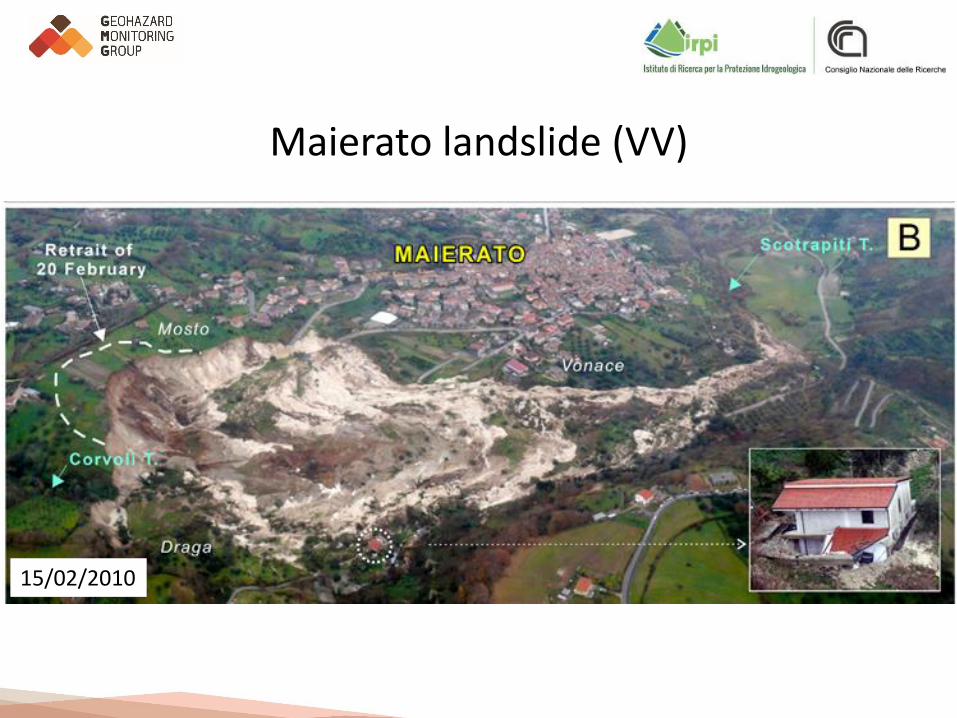
Maierato landslide (VV)
3
• 15 February 2010;• rapidly moving rotational slide;• ~ 5 million cubic meters;• sub vertical main scarp ~ 50 meters;• the landslide was triggered by
intense and long-lasting rainfalls;• loss of about 18 ha of farmland
(olive orchards);• endangering of water and methane
supply systems;• damage of ~ 800 m of a road;• 20 February 2010, 80 meters retreat
of the scarp.
Borrelli, L.; Antronico, L.; Gullà, G.; Sorriso-Valvo, G.M. Geology, geomorphology and dynamics of the 15 February 2010 Maierato landslide (Calabria, Italy). Geomorphology 2014, 208, 50–73.
Maierato landslide (VV)
15/02/2010

Maierato landslide (VV)
27/11/2018

Methodology outline
7
Structurefrom Motion
UAV survey
DJI Phantom4 Pro
GCP survey
Leica 1200RTK-VRS
DEM
ORTHOIMAGE

UAV surveys
8
2018 Flight
Images 2438
Extent [Km²] 0.981
Orthoimage groundresolution [cm/pix]
2.44
DEM cellsize [m] 0.05

‘‘Historical’’ data
9
nominal scale 1:4000
Orthoimage (2007) DTM interpolated from 1996 vector map
Pre-landslide data 1996 ÷ 2007
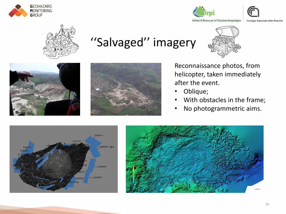
‘‘Salvaged’’ imagery
10
Reconnaissance photos, from helicopter, taken immediatelyafter the event.• Oblique;• With obstacles in the frame;• No photogrammetric aims.

Available DEMs
11
Year Source Methodology Resolution [m]
1996 Photogrammetry Interpolation 5.00
2010 Reconnaissance SfM 0.60
2017 UAV SfM 0.05
2018 UAV SfM 0.05
Year GCP XY error [cm] Z error [cm] Total error [cm]
2010 8 63.09 14.29 64.69
2017 11 2.67 2.25 3.49
2018 13 1.12 0.54 1.24

DODs
12
1996 - 2010 2010 - 2018
1996 - 2018
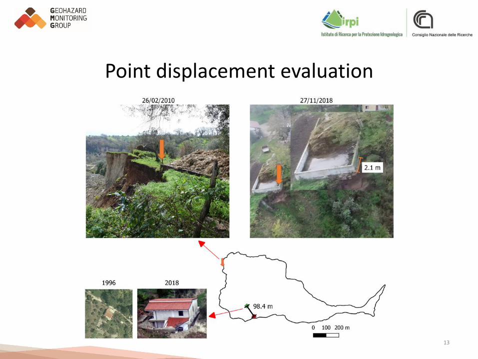
Point displacement evaluation
13

Conceptual summary
14
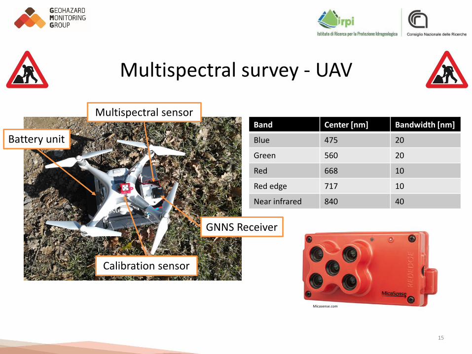
Multispectral survey - UAV
15
GNNS Receiver
Multispectral sensor
Calibration sensor
Battery unit
Band Center [nm] Bandwidth [nm]
Blue 475 20
Green 560 20
Red 668 10
Red edge 717 10
Near infrared 840 40
Micasense.com

Multispectral survey - CIR composite
16
A. dense tree cover in stress;B, C. pioneer vegetation in stress
on scarcely evolved soils;D. trees in healthy condition.

Concluding remarks
17
METHODOLOGY
• UAV surveys have provided encouraging results in the monitoring of the landslide;
• Monitoring data will be helpful in residual risk assessment and management;
• The methodology is feasible for a low cost, post emergency, monitoring;
• Multispectral data have provided further hints for the interpretation of the
phenomenon;
• SfM algorithms have confirmed their potential even in processing a salvaged
dataset.
LANDSLIDE
• The landslide formed a 54 meters scarp;
• The retreat of the scarp is still in progress;
• The erosion of the non channeled sector of the river is clearly depicted;
• In the deposit sector huge limestone blocks emerged from the matrix;
• The vegetated banks of the channeled sector of the river are growing but in stress
conditions.

Concluding remarks
18