A Semantic Location Service for Pervasive Grids
16
Consiglio Nazionale delle Ricerche Istituto di Calcolo e Reti ad Alte Prestazioni A Semantic Location Service for Pervasive Grids G. De Pietro – A. Coronato – M. Esposito RT-ICAR-NA-06-05 03-2006 Consiglio Nazionale delle Ricerche, Istituto di Calcolo e Reti ad Alte Prestazioni (ICAR) – Sede di Napoli, Via P. Castellino 111, I-80131 Napoli, Tel: +39-0816139508, Fax: +39- 0816139531, e-mail: [email protected], URL: www.na.icar.cnr.it 1
Transcript of A Semantic Location Service for Pervasive Grids
Consiglio Nazionale delle Ricerche Istituto di Calcolo e Reti ad Alte Prestazioni
A Semantic Location Service for
Pervasive Grids
G. De Pietro – A. Coronato – M. Esposito
RT-ICAR-NA-06-05 03-2006
Consiglio Nazionale delle Ricerche, Istituto di Calcolo e Reti ad Alte Prestazioni (ICAR) – Sede di Napoli, Via P. Castellino 111, I-80131 Napoli, Tel: +39-0816139508, Fax: +39-0816139531, e-mail: [email protected], URL: www.na.icar.cnr.it
1
Consiglio Nazionale delle Ricerche Istituto di Calcolo e Reti ad Alte Prestazioni
A Semantic Location Service for
Pervasive Grids
G.. De Pietro1 – A. Coronato2 – M. Esposito1
Rapporto Tecnico N.: RT-ICAR-NA-06-05
Data:03-2006
1 Istituto di Calcolo e Reti ad Alte Prestazioni, ICAR-CNR, Sede di Napoli, Via P. Castellino 111, 80131 Napoli 2 Sviluppo ed Applicazione dei Sistemi Informativi Territoriali, SASIT-CNR, Sede di Napoli, Via P. Castellino 111, 80131 Napoli I rapporti tecnici dell’ICAR-CNR sono pubblicati dall’Istituto di Calcolo e Reti ad Alte Prestazioni del Consiglio Nazionale delle Ricerche. Tali rapporti, approntati sotto l’esclusiva responsabilità scientifica degli autori, descrivono attività di ricerca del personale e dei collaboratori dell’ICAR, in alcuni casi in un formato preliminare prima della pubblicazione definitiva in altra sede.
2
A Semantic Location Service for Pervasive Grids
A. Coronato1, G. De Pietro2 and M. Esposito2
1SASIT-CNR, Via Castellino 111, 80131 Napoli, Italy
{[email protected]} 2ICAR-CNR, Via Castellino 111, 80131 Napoli, Italy
{giuseppe.depietro,[email protected]}
+
Abstract: In the last decade, Grid Computing and Pervasive Computing
paradigms have emerged and rapidly affirmed. These two worlds,
however, can no longer be separated islands. As a matter of fact,
traditional grids are moving towards Pervasive Grid environments and,
as a result, they benefit from both grid and mobile technologies. In
particular, a key feature of the Pervasive Computing paradigm, like the
location-awareness, can be used to enhance the QoS of existing Grid
services, that is Pervasive Grids should customize services access
depending on mobile objects locations. But, in these environments, such
as in the Pervasive environments, different types of positioning systems
can be used to determine mobile objects locations and each of them
produces location information with a specific format and granularity.
This paper presents a location service that locates active mobile objects,
such as Wi-Fi enabled devices and RFID tagged entities, in Pervasive
Grids. The key feature of the service is the use of ontologies and rules
to define a uniform, unambiguous and well-defined model for the
location information, independently from the particular positioning
system. Moreover, the location service performs logic and reasoning
mechanisms both for providing physical and semantic locations of
mobile objects and for giving the location information with the finest
granularity when a mobile object is located by more than one
positioning system. The service has been developed at the top of the
standard OGSA architecture.
1 Introduction
During the last decade, new computing models have emerged and rapidly
affirmed. In particular, terms like Grid Computing and Pervasive Computing have
become of common use, not only in the scientific and academic world, but also in
business fields.
The Grid Computing paradigm enables resource sharing and coordinated problem
solving in dynamic multi-institutional organizations [1]. Grid denotes the
virtualization of geographically distributed computing and data resources, such as
processing, network bandwidth and storage capacity, to create a single system image,
granting heterogeneous users and applications seamless access to vast IT capabilities
[2].
Differently, the goal for Pervasive Computing is the development of environments
where highly heterogeneous hardware and software components can seamlessly and
spontaneously interoperate, in order to provide a variety of services to users
independently of the specific characteristics of the environment and of the client
devices [3]. Therefore, mobile devices should come into the environment in a natural
way, as their owner moves, and transparently, that is owner will not have to carry out
manual configuration operations for being able to approach the services and the
resources.
These two worlds are now evolving towards a common paradigm, namely the
Pervasive Grid Computing [4]. As a matter of fact, Pervasive Computing
environments can proficiently benefit from grid technologies both to interconnect
existing and emerging pervasive environments and to build and deploy new services
that require high performance computing and large data resources Errore. L'origine
riferimento non è stata trovata..
On the other hand, from the Grid Computing community point of view, it’s now
time to integrate mobile devices into the grid because they are becoming of common
use for accessing to services in any distributed environment.
In particular, a key feature of the Pervasive Computing, like the location-
awareness, can be used to enhance the QoS of existing Grid services, that is Pervasive
Grid environments should customize services access depending on mobile users and
objects locations.
Diverse types of wireless and wired positioning systems can be used to detect
presence and proximity of people and mobile objects. The inter-working of more than
one positioning system can undeniably provide a synergetic approach of localization,
but it requires that Pervasive Grids be supported by advanced location services able
to integrate the location information coming from different sources. Indeed, each
positioning system produces location data characterized by a specific representation
and granularity.
In this paper, we propose a Semantic Location service which localizes mobile
objects in Pervasive Grid environments. The service exploits the inter-working of
more than one positioning system, by utilizing the Semantic Web technologies [6].
Besides, we define a unique and unambiguous model for localization issues for
integrating positioning systems. This model has been applied for integrating two
specific types of positioning systems, respectively based on Wi-Fi and RFID
technologies.
Moreover, the location service performs logic and reasoning mechanisms in order
to generate semantic information from physical locations or to give the location
information with the finest granularity when a mobile object is located by more than
one positioning system.
The service has been developed at the top of the standard OGSA (Open Grid
Services Architecture) and so may easily extend traditional OGSA-compliant Grids.
The rest of the paper is organized as follows. Section 2 discusses some
motivations and related work. Section 3 overviews a proposal of location model for a
Pervasive Grid. Section 4 describes the location service and outlines the
implementation details. In section 5 we present our Pervasive Grid environment and
describe some applicative scenarios. Finally, section 6 concludes the paper.
2 Motivations and related work
2.1 Motivations
Mobile and wireless devices have not been considered, for a long, as useful
resources by traditional Grid environments. However, considering the Metcalfe’s
low, which claims that usefulness of a network-based system proportionally grows
with the number of active nodes, and also considering that mobile devices capabilities
have substantially be improved over the time, it can justifiably be stated that mobile
and wireless devices are now of interest for the Grid community [21].
Over the last years, some valuable efforts have been done in order to make Grid
architectures able to support wireless technologies and mobile devices. In particular,
the paradigm of Mobile Grid or Wireless Grid has been proposed [5,10,11,12]. More
recently, this paradigm has evolved in the Pervasive Grid model [4,5], which again
aims at making Grid environments able to integrate mobile devices, but in a pervasive
way, that is seamlessly and transparently. In addition to this, the final objective is to
enhance Grid environments with characteristics that are typically found in Pervasive
environments like the location-awareness.
As a matter of fact, several Pervasive Grid services have to be location-aware, that
is they can require location information to cover their needs. But Pervasive Grids,
such as classic Pervasive environments, can be equipped with a multitude of different
positioning systems able to locate mobile entities.
Ideally, a positioning technology should provide both complete and accuracy
location information. In the absence of an ideal solution, multiple technologies are
used and each of them can face specific requirements, that is we can utilize a Wi-Fi
based system for locating mobile devices or an RFID based system for locating
mobile tagged users. Besides, the emerging of new technologies doesn’t produce the
replacing of the old ones, but the integration of the new and old systems is realized by
placing them side by side.
As a result, this increases the complexity of the location-aware services, for the
following reasons: i) the services should deal with many and different positioning
systems and their low-level protocols; ii) they should know all the specific
representations, defined and used by the positioning systems, for location
information. Besides, they should convert the location information from each specific
representation to an internal one and this produces several different representations
for each service; iii) additional location information, such as the semantic location
(that is the meaning of a location) should be produced by the specific services.
2.2 Our contribution
This paper proposes an enhanced location service able i) to localize mobile entities
by using diverse types of positioning systems and localization techniques and ii) to
integrate location information characterized by a specific format and granularity.
In detail, our work consists in the following issues:
• Semantic integration of different positioning systems: The location service
exploits the inter-working of more than one positioning system i) by hiding
the specific details of the positioning systems and ii) granting both the
syntactic as well as the semantic interoperability between services and the
positioning systems.
• Definition of a location model: We have defined a location model able to i)
provide a unique and uniform representation for location information,
independently from the particular positioning system; ii) represent both
physical and semantic location of mobile objects of a Pervasive Grid. We
have developed the location model by using the Semantic Web technologies
and in particular OWL [22] ontologies and SWRL [21] rules.
• Logic and reasoning mechanisms: The location service performs logic and
reasoning mechanisms in order to generate semantic information from
physical positions or to give the location information with the finest
granularity when a mobile object is located by more than one positioning
system.
• Integration with the Globus Toolkit: The location service has been
developed at the top of the standard OGSA (Open Grid Services
Architecture). Then, it has been integrated with the Globus Toolkit [19],
which is the the-facto standard platform for Grid applications, and as a result,
provides mechanisms for augmenting classic grid environments with a
pervasive characteristic like the location-awareness.
2.3 Related work
In the last few years location-aware computing and services have been of interest
in several research areas, but the mobile devices, and consequently the issues related
to the localization, have been largely discriminated by Grid computing. Besides, no
relevant experiments have been performed in Pervasive Grids. Differently, a number
of pervasive computing systems can be described by the terms location or context-
aware and in particular the approaches adopted in [8,9] are illustrated below.
In [8] the author presents a flexible platform for location-based services, which
hides specific details of positioning systems and provides a uniform representation of
both physical and semantic information. The corresponding infrastructure reflects a
location domain model, which defines a semantic structure of the entire location
space. This structure is composed of hierarchies that are built up of domains and
logical links between domains. A domain represents a semantic location, whereas a
link is the expression of a semantic relation between locations.
Differently, our approach relies on the Semantic Web technologies, and so it
grants both the syntactic as well as the semantic interoperability between services and
the positioning systems. Besides, the platform proposed in [8] doesn’t provide a
support for location reasoning, that is no logic mechanisms have been realized for
obtaining semantic locations from physical ones or for determining the location
information with the finest granularity when a mobile object is located by more than
one positioning system.
CoBrA [9] is an architecture to support context-aware services in smart spaces. It
locates mobile entities by using two types of positioning systems, respectively based
on RFID and Bluetooth technologies. Besides, a set of ontologies has been defined
for modelling context information. Semantic Web languages are used for representing
them and for supporting context reasoning.
Nevertheless, CoBrA doesn’t aim at realizing a semantic integration of different
types of positioning technologies. As a result, the context ontologies don’t model the
location information coming from positioning systems but provide only a uniform
and well-defined representation for the semantic locations which can characterize an
environment. This choice is purely based on the type of context-aware applications to
be supported in prototyping CoBrA.
3 The Semantic Approach
3.1 Our proposal of a location model
The approach presented in this paper relies on a location model that we have
defined to provide a unique and uniform representation for location information,
independently from the particular positioning system.
The model is based on the ideas of physical and semantic locations. These notions
are not new in literature [13], but we have partially re-elaborated them.
Physical locations specify the position of mobile entities and are characterized by
different granularities and scopes, depending on the particular positioning system.
Instead, a semantic location specifies the meaning of a location and usually covers
more physical locations. As an example, physical locations can be GPS coordinates,
whereas a semantic location can be a building, an office inside a building, a meeting
room, a railway station and so on.
In particular, our model describes the physical locations that can be specified by
determining the proximity to well-known points, but it can also be easily extended by
defining other types of physical locations.
The technique of proximity requires the environment be equipped with
infrastructures of sensors, that reveal mobile users presence, or of particular devices
to which mobile users can connect, for example to access the Internet. So, the
physical locations we have modeled are not referred to coordinate systems, but
identify the regions, called sensed areas, covered by a positioning system.
We have focused on two specific types of positioning systems, respectively based
on Wi-Fi and RFID technologies, and so we have defined two types of sensed areas:
a Wi-Fi sensed area, which is identified by the physical location covered by a
specific wireless Access Point (AP), i.e. a mobile entity is located by an AP when her
mobile device becomes active into its area;
an RFID sensed area, which is identified by the physical location covered by a
specific RFID reader, i.e. a mobile entity is located by an RFID reader when her
RFID tag is sufficiently near it.
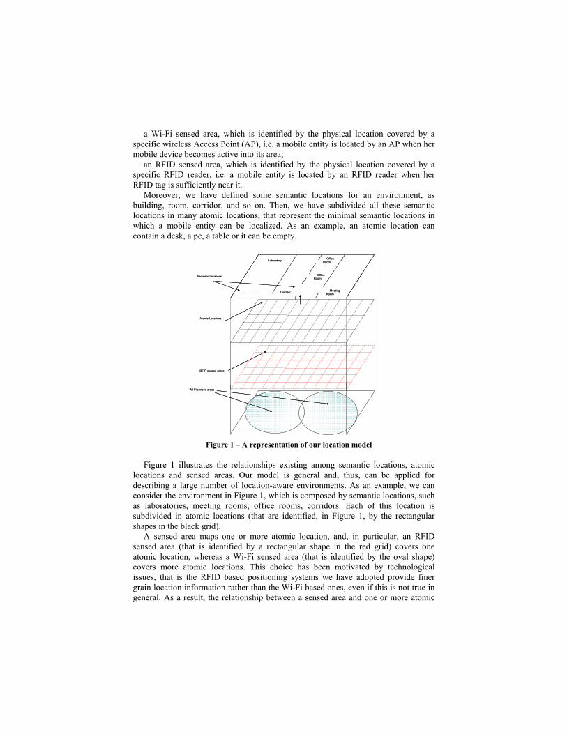
Moreover, we have defined some semantic locations for an environment, as
building, room, corridor, and so on. Then, we have subdivided all these semantic
locations in many atomic locations, that represent the minimal semantic locations in
which a mobile entity can be localized. As an example, an atomic location can
contain a desk, a pc, a table or it can be empty.
Figure 1 – A representation of our location model
Figure 1 illustrates the relationships existing among semantic locations, atomic
locations and sensed areas. Our model is general and, thus, can be applied for
describing a large number of location-aware environments. As an example, we can
consider the environment in Figure 1, which is composed by semantic locations, such
as laboratories, meeting rooms, office rooms, corridors. Each of this location is
subdivided in atomic locations (that are identified, in Figure 1, by the rectangular
shapes in the black grid).
A sensed area maps one or more atomic location, and, in particular, an RFID
sensed area (that is identified by a rectangular shape in the red grid) covers one
atomic location, whereas a Wi-Fi sensed area (that is identified by the oval shape)
covers more atomic locations. This choice has been motivated by technological
issues, that is the RFID based positioning systems we have adopted provide finer
grain location information rather than the Wi-Fi based ones, even if this is not true in
general. As a result, the relationship between a sensed area and one or more atomic
RFID sensed areas
Atomic Locations
Office
Room
Office
Room
Laboratory
Corridor
WI-FI sensed areas
Semantic Locations
Meeting
Room
RFID sensed areas
Atomic Locations
Office
Room
Office
Room
Laboratory
Corridor
WI-FI sensed areas
Semantic Locations
Meeting
Room
locations allows to identify the atomic and also the semantic location of a mobile
entity.
3.2 Ontologies and rules for our location model
The location model defines location information in a unique and uniform way, but
these information must be represented in an unambiguous and well-defined formalism
and expressed in a machine-readable format. Besides, it has to provide a support for
granting both the syntactic and the semantic interoperability between the
environments and positioning systems.
The Semantic Web technologies, which have been widely applied in many areas in
the recent past, can be used to face such needs because: i) ontologies and rules
respectively enable the definition of domain vocabularies and allow declarative data
processing, by providing a way to share knowledge without misunderstandings; ii)
RDF [10], SWRL and OWL are semantic representation languages with high degree
of expressiveness; iii) ontologies and rules can be reasoned by logic inference
engines. We can use ontologies and rules coupled with subsets of first order logics to
infer new knowledge and to ensure that the system is always in a consistent state.
Therefore, we have modeled three OWL ontologies and a set of SWRL rules
related to location issues. In the following, a brief description for the defined
ontologies and rules is reported.
The first ontology models all the concepts for defining semantic locations.
Location is the root concept of this ontology and represents the generic location of an
environment. Each location has a name and can contain or be contained in an other
location. Room, Building, Floor and Corridor represent the particular semantic
locations of such an environment. They are sub-concepts of the Location concept,
and, as a result, each of them inherits the super-concept properties and adds new
specialized features to them. For instance, a building is characterized by an address, a
number of floors and is composed by corridors, floors and rooms (that is, these
concepts are related to the Building concept by a whole-part relationship). We also
define different types of rooms, as office-room, meeting-room and laboratory, by
specializing the Room concept.
All these possible semantic locations are composed by atomic locations and so all
the sub-concepts of Location are related to the Atomic Location concept by a whole-
part relationship.
The graphical representation of this ontology is reported in Figure 2.
isPartOf
subclassof
Building
AtomicLocation
Location
Room Floor
MeetingRoom
OfficeRoom
Laboratory
Corridor
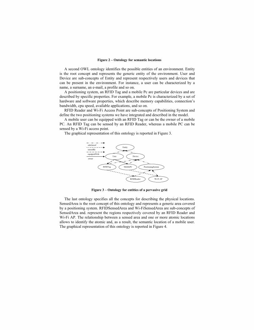
Figure 2 – Ontology for semantic locations
A second OWL ontology identifies the possible entities of an environment. Entity
is the root concept and represents the generic entity of the environment. User and
Device are sub-concepts of Entity and represent respectively users and devices that
can be present in the environment. For instance, a user can be characterized by a
name, a surname, an e-mail, a profile and so on.
A positioning system, an RFID Tag and a mobile Pc are particular devices and are
described by specific properties. For example, a mobile Pc is characterized by a set of
hardware and software properties, which describe memory capabilities, connection’s
bandwidth, cpu speed, available applications, and so on.
RFID Reader and Wi-Fi Access Point are sub-concepts of Positioning System and
define the two positioning systems we have integrated and described in the model.
A mobile user can be equipped with an RFID Tag or can be the owner of a mobile
PC. An RFID Tag can be sensed by an RFID Reader, whereas a mobile PC can be
sensed by a Wi-Fi access point.
The graphical representation of this ontology is reported in Figure 3.
owner
equippedWith
sensedBy
subclassof
RFIDReader Wi-Fi AP
MobilePC
PositioningSystem
Entity
Device
User
RFIDTag
Figure 3 – Ontology for entities of a pervasive grid
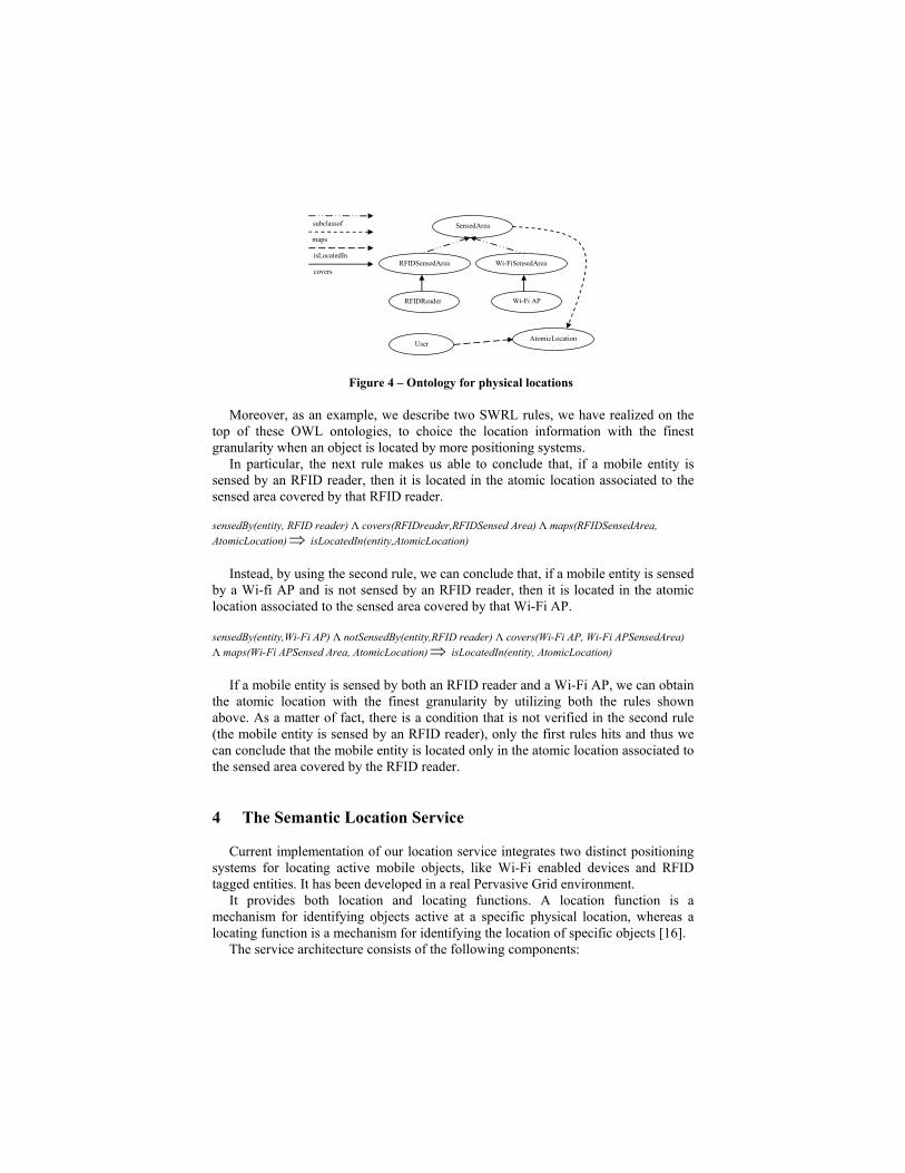
The last ontology specifies all the concepts for describing the physical locations.
SensedArea is the root concept of this ontology and represents a generic area covered
by a positioning system. RFIDSensedArea and Wi-FiSensedArea are sub-concepts of
SensedArea and. represent the regions respectively covered by an RFID Reader and
Wi-Fi AP. The relationship between a sensed area and one or more atomic locations
allows to identify the atomic and, as a result, the semantic location of a mobile user.
The graphical representation of this ontology is reported in Figure 4.
Wi-Fi AP
AtomicLocation
RFIDReader
User
SensedArea
RFIDSensedArea
Wi-FiSensedArea covers
isLocatedIn
maps
subclassof
Figure 4 – Ontology for physical locations
Moreover, as an example, we describe two SWRL rules, we have realized on the
top of these OWL ontologies, to choice the location information with the finest
granularity when an object is located by more positioning systems.
In particular, the next rule makes us able to conclude that, if a mobile entity is
sensed by an RFID reader, then it is located in the atomic location associated to the
sensed area covered by that RFID reader.
sensedBy(entity, RFID reader) Λ covers(RFIDreader,RFIDSensed Area) Λ maps(RFIDSensedArea,
AtomicLocation)⇒ isLocatedIn(entity,AtomicLocation)
Instead, by using the second rule, we can conclude that, if a mobile entity is sensed
by a Wi-fi AP and is not sensed by an RFID reader, then it is located in the atomic
location associated to the sensed area covered by that Wi-Fi AP.
sensedBy(entity,Wi-Fi AP) Λ notSensedBy(entity,RFID reader) Λ covers(Wi-Fi AP, Wi-Fi APSensedArea)
Λ maps(Wi-Fi APSensed Area, AtomicLocation)⇒ isLocatedIn(entity, AtomicLocation)
If a mobile entity is sensed by both an RFID reader and a Wi-Fi AP, we can obtain
the atomic location with the finest granularity by utilizing both the rules shown
above. As a matter of fact, there is a condition that is not verified in the second rule
(the mobile entity is sensed by an RFID reader), only the first rules hits and thus we
can conclude that the mobile entity is located only in the atomic location associated to
the sensed area covered by the RFID reader.
4 The Semantic Location Service
Current implementation of our location service integrates two distinct positioning
systems for locating active mobile objects, like Wi-Fi enabled devices and RFID
tagged entities. It has been developed in a real Pervasive Grid environment.
It provides both location and locating functions. A location function is a
mechanism for identifying objects active at a specific physical location, whereas a
locating function is a mechanism for identifying the location of specific objects [16].
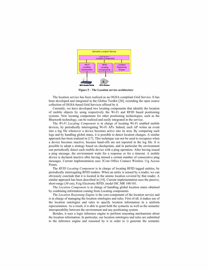
The service architecture consists of the following components: