
2° Workshop internazionale -...
22
Transcript of 2° Workshop internazionale -...

2° Workshop internazionaleI SinkholesGli sprofondamenti catastrofici nell’ambientenaturale ed in quello antropizzato
Roma, 3-4 Dicembre 2009Auditorium ISPRA, Via Curtatone 7, 00185 Roma
Coordinamento Scientifico: Stefania Nisio
Comitato tecnico scientifico:Marco Amanti, Mario Aversa, Vincenzo Buchignani, Giuseppe Capelli,Ernesto Centamore, Giancarlo Ciotoli, Stefano Cremonini, Franco Cucchi,Orazio De Angelis, Michele Di Filippo, Francesco Dramis, Calvino Gasparini,Massimo Grisolia, Paolo Maria Guarino, Giulio Iovine, Salvatore Lombardi,Luigi Micheli, Stefania Nisio, Fabio Meloni, Mario Parise, Marco Petitta,Antonio Santo, Gabriele Scarascia Mugnozza, Marcello Schiattarella, Fran-cesco Stoppa, Beniamino Toro, Giulia Ventura.

ACTIVITY OF THE ITALIAN NATIONAL RESEARCH COUNCILIN THE AFTERMATH OF THE 6 APRIL 2009, ABRUZZOEARTHQUAKE: THE SINIZZO LAKE CASE STUDYdi Parise M.1, Perrone A.2, Violante C.3, Stewart J.P.4, Simonelli A.5 & Guzzetti F.1,6
ABSTRACT
The 6 April 2009, earthquake (Mw = 6.3) that hit L’Aquila and the Abruzzo region, centralItaly, caused 306 fatalities, widespread damage to structures and infrastructure, grounddeformations and multiple instability phenomena. The National Research Council (CNR)operated in the epicenter and the surrounding area immediately after the main shocksto complete field surveys and geomorphological and geophysical analyses aimed at theevaluation of individual hazards related to seismically-induced slope failures and groundinstabilities. This work describes the research activities performed at the Sinizzo Lake,near San Demetrio ne’ Vestini, a sinkhole where open cracks were observed immediatelyafter the earthquake.Teams from different Institutions were involved in the study, underthe general coordination of the CNR Department of Earth and Environmental Sciences.The Sinizzo lake is located less than 1 km east of the village of San Giovanni, in the SanDemetrio ne’ Vestini municipality. Circular in shape, and with a diameter of some 120 m,the lake has been subject to man made modifications, including an artificial barrier toincrease the lake depth, currently around 10 m. Steep slopes that have been locallyaffected by small-volume rock falls, a consequence of the 6 April 2009 earthquake, char-acterize the surrounding area. Following the main shocks, open cracks and evident grounddeformations formed on the lakeshore, and evolved rapidly in the following days. To char-acterize the geometry and structure of soils cropping out in the area, and to assess theintegrity of the artificial barrier that raises the shoreline locally, four electric resistivitytomographies (ERT) were performed perpendicular and parallel to the western shore ofthe lake. The ERT highlighted terrains characterized by different geoelectrical properties,allowed estimating the thickness of the shallow layers, and to identify vertical and hori-zontal discontinuities in the subsoil. High-resolution, multi-beam bathymetry of the lake wasperformed, and the processed data used to generate a digital elevation model with aground resolution of 5 cm x 5 cm. Comparison of the obtained results with pre-existingsingle-beam bathymetric data indicates no significant difference in the general configura-tion and depth of the lake-floor. The most relevant feature is an incipient instability along
623
1 CNR IRPI (Istituto di Ricerca per la Protezione Idrogeologica, Consiglio Nazionale delle Ricerche)2 CNR IMAA (Istituto di Metodologie per l’Analisi Ambientale, Consiglio Nazionale delle Ricerche)3 CNR IAMC (Istituto per l’Ambiente Marino Costiero, Consiglio Nazionale delle Ricerche)4 University of California, Los Angeles, USA5 Università del Sannio, Benevento6 CNR DTA (Dipartimento Terra e Ambiente, Consiglio Nazionale delle Ricerche)

624
the eastern side of the lake, outlined by an irregular morphological step with a concaveshape in plan-view, possibly locally evolving into an open fracture.
RIASSUNTO
Il terremoto del 6 Aprile 2009 (Mw = 6.3) che ha colpito L’Aquila e l’Abruzzo ha causato306 morti, danni ingenti agli edifici ed alle infrastrutture, deformazioni del suolo e diversifenomeni di instabilità dei versanti. Immediatamente dopo il sisma, il Consiglio Nazionaledelle Ricerche (CNR) ha operato nell’area epicentrale e nelle zone limitrofe, effettuandosopralluoghi e indagini geomorfologiche e geofisiche mirate a valutare la pericolositàconnessa a specifici fenomeni di instabilità dei versanti indotti dal sisma. Questo lavorodescrive le attività di ricerca condotte al Lago Sinizzo, presso San Demetrio ne’ Vestini,un’ampia dolina all’interno della quale subito dopo il terremoto si sono aperte evidenti frat-ture. Gruppi di ricerca di diverse Istituzioni hanno partecipato allo studio, con il coordina-mento del Dipartimento Terra e Ambiente del CNR. Il Lago Sinizzo è situato a meno di 1km a Est dall’abitato di San Giovanni, frazione di San Demetrio ne’ Vestini. Di forma circo-lare, e con un diametro di circa 120 metri, il lago è stato in passato oggetto di modificheantropiche, fra le quali la realizzazione di uno sbarramento che ha portato il lago allaprofondità attuale di circa 10 metri. L’area circostante è caratterizzata da versanti acclivi,che sono stati interessati da crolli in roccia di volumi medio-piccoli in conseguenza delsisma del 6 Aprile 2009. A seguito delle scosse principali, lungo le sponde del lago si èformato un evidente sistema di fratture concentriche, associato a deformazioni del suolo,in rapida evoluzione. Per caratterizzare la geometria e la struttura dei terreni affiorantinell’area, e per valutare l’integrità dello sbarramento artificiale, sono state eseguitequattro tomografie elettriche (ERT), in direzione parallela e perpendicolare al margineoccidentale del lago. Le tomografie hanno consentito di individuare terreni con diverseproprietà geo-elettriche, di stimare lo spessore degli strati superficiali, e di identificarediscontinuità verticali e orizzontali presenti nel sottosuolo. E’ stata realizzata una batime-tria ad alta risoluzione nel lago, e i dati ottenuti hanno permesso di generare un modellodigitale con risoluzione di 5 cm x 5 cm. Il confronto con una batimetria del lago prece-dente non ha rilevato differenze sostanziali nella configurazione e nella profondità delfondo del lago. L’elemento più significativo è un fenomeno di instabilità incipiente lungo lasponda orientale, evidenziato da un gradino morfologico irregolare di forma concava inpianta, che localmente pare evolvere in una frattura.
1. INTRODUCTION
In addition to the direct effects caused to the built up environment, earthquakes cantrigger multiple types of ground instabilities, and produce indirect – locally severe –effects to the natural environment (KEEFER, 1984). Rockfalls and topples are the mostcommon type of seismically induced slope failures, that can be triggered by earthquakesof magnitude 4.0, or larger (MC CALPIN & NELSON, 1996). Among the other possible groundinstabilities, reactivation and formation of sinkholes have also been observed (YULE & GRAU,2003; WALTHAM et alii, 2005, and references therein; PARISE, 2008). On 6 April 2009, at 01:32:39 UTC (03:32:39 local time), the Abruzzo Region, centralItaly, was shaken by a severe earthquake of local magnitude ML = 5.8 (moment magni-tude Mw = 6.3). The epicenter of the earthquake was located WSW of l’Aquila at a depth
of about 8.8 km. On April 7 and April 9, two earthquakes of ML > 5 occurred in the samegeneral area: the first (ML = 5.3) was located 11 km SSE of l’Aquila, and the second (ML
= 5.1) 15 km NNW of l’Aquila. The 6 April 2009 earthquake (Mw = 6.3) that hit l’Aquilaand the Abruzzo Region caused multiple ground deformations and widespread slope insta-bilities, chiefly rockfalls. The main seismic event took place along a normal fault trendingNW-SE, and dipping southwest. The earthquake was the largest event in a seismicsequence that had started a few months earlier and had its most significant previousevent on March 30, 2009. The Italian National Research Council (CNR) operated in the epicentral area and thesurrounding region immediately after the main shocks, to complete field surveys andgeomorphological and geophysical analyses aimed at the evaluation of individual hazardsposed by earthquake induced slope failures and ground instabilities. In this work, wedescribe the activities conducted at the Sinizzo Lake, near San Demetrio ne’ Vestini, asinkhole where open cracks were observed immediately after the main shocks. Teamsfrom multiple Institutions contributed to the study, under the general coordination of CNRDepartment of Earth and Environmental Sciences. The study area is located less than onekilometre east of the village of San Giovanni, in the San Demetrio ne’ Vestini Municipality.The Sinizzo Lake is one of several karst landforms present in the middle reach of theAterno river valley (NISIO, 2008).
2. GEOLOGICAL SETTING
The epicentral area of the 6 April 2009 earthquake sequence is located in the CentralItalian Apennines. In the area crop out stiff, carbonate platform limestone and turbiditesediments deposited in fore-deep basins, and progressively incorporated in the Apenninesfold-and-thrust belt during its migration from West to East (ACCORDI et alii, 1988; MELETTI
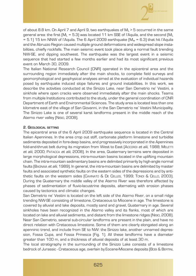
et alii, 2000; PATACCA et alii, 2008). In the area, Quaternary terrains were deposited inlarge morphological depressions, intra-mountain basins located in the uplifting mountainchain. The intra-mountain sedimentary basins are delimited primarily by high-angle normalfaults (BAGNAIA et alii, 1989). In general, the intra-mountain basins are delimited by masterfaults and associated synthetic faults on the eastern sides of the depressions and by anti-thetic faults on the western sides (CAVINATO & DE CELLES, 1999; TONDI & CELLO, 2003).During the Quaternary the middle valley of the Aterno River was therefore affected byphases of sedimentation of fluvio-lacustrine deposits, alternating with erosion phasescaused by tectonics and climatic changes.San Demetrio ne’ Vestini is located on the left side of the Aterno River, on a small ridgetrending NW-SE consisting of limestone, Cretaceous to Miocene in age. The limestone iscovered by alluvial and lake deposits, mostly sand and gravel, Quaternary in age. Severalsinkholes have been recognized in the Aterno valley and its flanks, most of which arelocated on lake and alluvial sediments, and distant from the limestone ridges (NISIO, 2008).Near San Demetrio, several sub-circular landforms are present in the plain, and have nodirect relation with Cretaceous limestone. Some of them are clearly elongated along anapenninic trend, and include from SE to NW: the Sinizzo lake, another unnamed depres-sion, Fossa Cupa, and Fossa Prinesca (Fig. 1). All these landforms have a diametergreater than 100 m, and a thickness of alluvial deposits of at least 30 m.The local stratigraphy in the surrounding of the Sinizzo Lake consists of a limestonebedrock of Jurassic - Cretaceous age, overlain by Eocene-Miocene deposits (BOSI & BERTINI,
625
626
Fig. 1 – Geology of the area (simplified after Bosi & Bertini, 1970). Key: 1) recent alluvial deposits(Holocene); 2) lower fluvio-lacustrine complex (Lower-Middle Pleistocene); 3) breccias and conglo-merates (Upper Pliocene – Lower Pleistocene); 4) Marl limestones (Lower-Middle Miocene); 5)Limestones (Jurassic – Cretaceous).
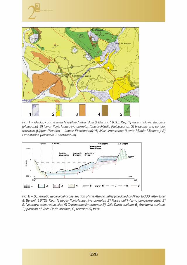
Fig. 2 – Schematic geological cross section of the Aterno valley (modified by Nisio, 2008, after Bosi& Bertini, 1970). Key: 1) upper fluvio-lacustrine complex; 2) Fossa dell’Inferno conglomerates; 3)S. Nicandro calcareous silts; 4) Cretaceous limestones; 5) Valle Daria surface; 6) Ansidonia surface;7) position of Valle Daria surface; 8) terrace; 9) fault.

1970; BERTINI et alii, 1989). For the goals of the present study, the most important litholo-gies are the Quaternary deposits, and in particular the so-called “lower fluvio-lacustrinecomplex”, consisting of the San Nicandro calcareous silts, and the overlying Fosso dell’In-ferno Conglomerates.The San Nicandro calcareous silts crop out extensively in the area, and are a soft rock,that locally may become more competent because of the greater degree of calcitecementation. Locally, the silts pass upward to whitish marls, due to an increase in thecontent of clay minerals. The calcareous silts represent the lower member of thecomplex, with thickness ranging from 2 m to more than 50 m. The largest thickness isin the central part of the basin, which includes the area between San Demetrio, SanNicandro, and the Sinizzo Lake. The passage to the overlying Fosso dell’Inferno Conglom-erates is gradually marked by gravel lenses with calcareous clasts, increasing in numberand dimensions towards the top.The Fosso dell’Inferno Conglomerates show rounded, prevailingly calcareous, clasts, inbeds ranging from 0.5 to several meters, with local intercalations of light calcareoussands and silty sands (maximum thickness 1m). Generally in sub-horizontal bedding, andwith 110-120 m overall thickness, the conglomerates represent a filling episode of thelacustrine basin, being related to sedimentation deriving from intense erosion of thesurrounding areas, with great amounts of coarse debris materials which reached thebasin, and deposited above the San Nicandro calcareous silts. Upward, the conglomer-ates end with a typical horizontal surface (named Valle Daria surface, at elevation about850 m a.s.l.), the likely filling surface of the Aquilan lacustrine basin (BOSI & BERTINI, 1970).On the opposite (W) valleyside of the Aterno River, there is the Ansidonia surface, whichaccording to a number of geometric and stratigraphic considerations by the sameAuthors, does not coincide with the Valle Daria, and corresponds to an older surface, eventhough similar in genesis (BOSI & BERTINI, 1970).Several portions of the Valle Daria surface are identifiable at different sites and heights,which testify to the occurrence of tectonic movements after the last phase of filling of thelacustrine basin. To summarize, the evolution of the middle reach of the Aterno River ischaracterized by a large lacustrine basin (Lago Aquilano), where filling ends with a widesurface extending from San Pelino to the Conca Subequana. A smaller basin (Sant’EusanioLake), probably resulting from tectonic events, originates afterwards within the bound-aries of the previous lake; the Sant’Eusanio lake has its eastern margin just below the areawhere nowadays the inhabited area of San Demetrio is located.The tectonic setting of the area is quite interesting, especially in terms of the evidence ofrecent movements: the reliefs on the left valleyside of the Aterno River are elongated inNW-SE direction, and correspond to monoclinal ridges dipping mostly to the N (locally,the NE and NW), bounded on the southwestern side by highly dipping (>50°) normal faults.The overall tectonic setting is completed by another fault system (NNE-SSW or NE-SWdirected, with sub-vertical dip) that dislocates the area in a number of blocks.The calcareous bedrock has been reconstructed in the middle reach of the Aterno Riverby means of geoelectric surveys, presented by BOSI & BERTINI (1970). In regard to thestudy area, the bedrock (showing ρ > 1000 Ωm) has been identified at depths greaterthan 500 m. In describing the geophysical results, the Authors found it was not possibleto identify with certainty the nature of the conductive cover above the bedrock: in fact,below a surface horizon of the recent alluvial deposits, the low measured values of resis-
627
628
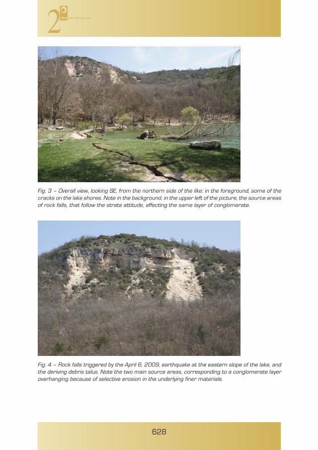
Fig. 3 – Overall view, looking SE, from the northern side of the like: in the foreground, some of thecracks on the lake shores. Note in the background, in the upper left of the picture, the source areasof rock falls, that follow the strata attitude, affecting the same layer of conglomerate.
Fig. 4 – Rock falls triggered by the April 6, 2009, earthquake at the eastern slope of the lake, andthe deriving debris talus. Note the two main source areas, corresponding to a conglomerate layeroverhanging because of selective erosion in the underlying finer materials.
tivity (ρ < 40 Ωm) could correspond to the San Nicandro calcareous silts, but also to themarls of the upper Miocene (BOSI & BERTINI, 1970). In regard to the geo-structural setting, fault systems have separated in the area manymonoclinal ridges that, on the left valley of the Aterno River, dip to the NE, bounded bynormal faults dipping SW (BOSI & BERTINI, 1970). Starting from the Pliocene, a distensionalphase begins, which is testified by movements and dislocations occurring after the lacus-trine sedimentation in lower Pliocene (BLUMETTI et alii, 1996), such as the disconformitiesin the fluvial conglomerates overlying the lacustrine deposits near San Demetrio ne’Vestini.The fault of Sinizzo Lake, located on the prolongation of the Paganica fault, belongs to thefault system that also includes the Annunziata and the San Demetrio faults (see Fig. 2).The Sinizzo Lake fault cuts Fosso dell’Inferno just downslope from the lake, and its mainevidence is represented by the abrupt lateral contact between the San Nicandrocalcareous silts, cropping out to the NE on both the flanks of Fosso dell’Inferno and alongthe road to San Nicandro, and the conglomerates to the SW. In addition, the fault is alsotestified by the Valle Daria surface (Fig. 2). The fault system creates a step structure,progressively uplifted toward the NE. Within this structure, some insights on the amountof the uplift related to the fault movements can be obtained by analysis of the original posi-tion of the filling surface of the lacustrine basin: in detail, the plate between the San
629
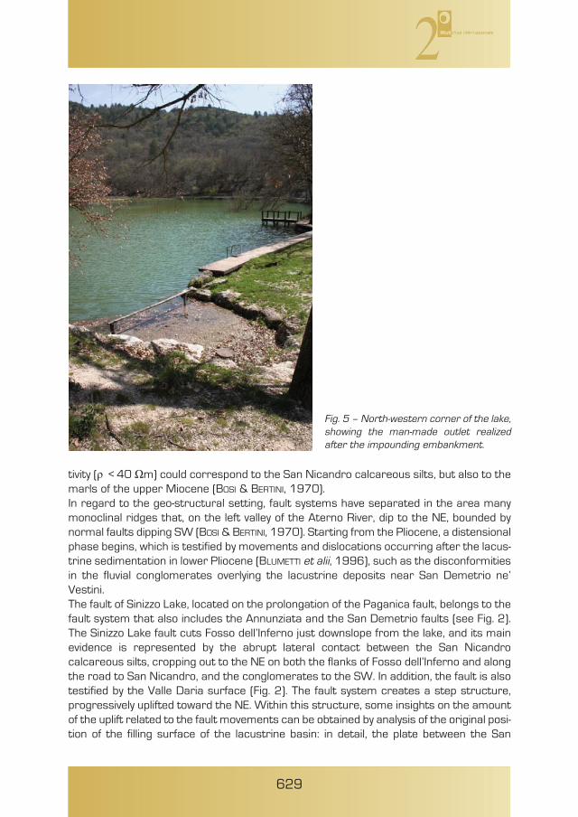
Fig. 5 – North-western corner of the lake,showing the man-made outlet realizedafter the impounding embankment.

Demetrio and the Sinizzo Lake faults should had been lowered irregularly, and atincreasing rate toward the NW (from a few meters in the area S of Sinizzo Lake, to some70 m at Fossa Cupa). The upslope plate, comprised between the lake and the ColleCicogna fault, is, on the other hand, uplifted in average about 100 m. In regard tochronology, it seems that these dislocations occurred after the development of the ValleDaria surface, but before the sedimentation of the upper fluvio-lacustrine complex, thedeposits of which do not present any offset.
3. The Sinizzo LakeLake Sinizzo is located east of the inhabited area of San Demetrio ne’ Vestini (Fig. 3).Circular in plan view, the lake has an average diameter of approximately 120 m. Theslopes around the lake are very steep at the southern and the eastern margin, where asub-vertical ridge is present. From the latter, medium-sized rock falls detached as a conse-quence of the 6 April 2009 earthquake (Fig. 4). The affected slope consists of alterna-tions of gravel and conglomerate layers with intercalations of finer horizons. The differ-ences in the physical characters of the materials determine selective erosion in corre-spondence of the less resistant horizons, which cause some conglomerate, morecompact layers, to overhang and occasionally fall, as experienced during the 6 April 2009earthquake.
630
Fig. 6 – Pictures showing the cracksdeveloped after the seismic shocks alongthe lake shorelines.
631
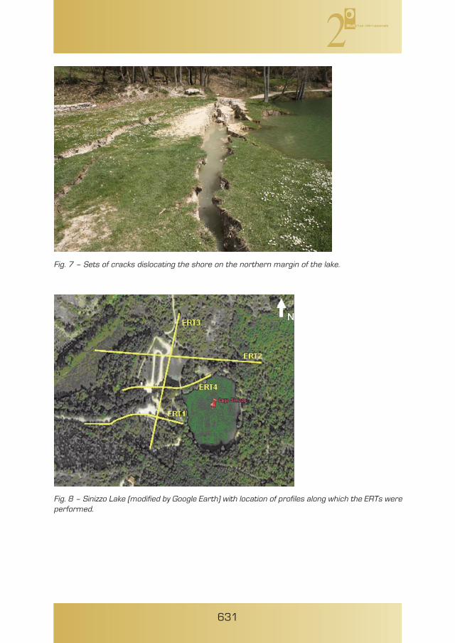
Fig. 7 – Sets of cracks dislocating the shore on the northern margin of the lake.
Fig. 8 – Sinizzo Lake (modified by Google Earth) with location of profiles along which the ERTs wereperformed.

632
Originally, the lake probably had a depth of about 7 meters, that was increased to 10 mafter realization of a 22.5 m-long impounding embankment (TETÈ et alii, 1984) at its north-western margin (Fig. 5). During the 16th century the lake was used to work hemp andlinen, and as a hydric resource as well. Remnants of the aqueduct, which reached theancient town of Corfinio in the Peligna Valley, were still visible in the 18th century (TETÈ etalii, 1984). In 1974 the lake was partly drained. A small spring is located at the northernperimeter of the lake; some Authors report that discharge of the spring was stronglydiminished, and its minimum value was recorded in July 1975, with 0.02 l/sec.In regard to the origin of the lake, the geographer ROBERTO ALMAGIÀ, describing the lakesin the Abruzzi region, refers that “the small lake at San Raniero near Civita di Bagno wasproduced by a sinkhole that occurred in 1352 or in 1353, and a similar genesis is prob-ably also at the origin of the nearby lake of San Giovanni and the Sinizzo Lake near SanDemetrio” (ALMAGIÀ, 1919); he therefore describes the Sinizzo Lake as an alluvial doline.MARINI (1976), claiming that the lake originated from a small spring, and that it is hostedin a Quaternary lacustrine clay-filled basin, disagrees with ALMAGIÀ’s hypothesis, andaffirms that the potential sinkhole would have been originated below the clay cover.As a consequence of the 6 April 2009 earthquake, several displacements occurred alongthe lake shores, and a number of open cracks developed (Figs. 6 and 7). The largestpermanent displacements (ranging from a few mm to more than 1,5 m) were registeredon the north and south shores respectively, which are also the sectors where the slopes
Fig. 9 – Electro Resistivity Tomographies(ERT) at Sinizzo Lake (location shown infigure 8): ERT1 carried out with directionperpendicular to the lake and parallel tothe access road to the area; ERT2 carriedout with direction perpendicular to thelake, across the artificial barrier built in thewestern side of the lake; ERT3 carried outwith direction parallel to the lake, acrossthe artificial barrier; ERT4, performed withdirection perpendicular to the lake,crosses the artificial barrier and can beconsidered as a zoom of the ERT2.

are more flat and gently sloping. The cracks had a rapid evolution during the 3-4 daysfollowing the main seismic shock, with progressive enlargement, and extension atdistances of more than 20 m from the shore. Based upon our direct field surveys, furtherconfirmed by other research groups (i.e., the Geotechnical Earthquake Engineering Recon-naissance; GEER ASSOCIATION, 2009), it was clear that the deformations were limited tothe Quaternary cover materials, and did not affect the nearby limestone deposits. The entire perimeter of the lake was affected by open cracks, with a trend sub-parallel tothe shore. At several locations, anastomosing crack arrays were observed. They gener-ally bounded individual slides that moved into the lake (see also farther on, the section onlake bathymetry).
4. GEOPHYSICAL SURVEYS
After fractures were observed along the shore of the Sinizzo Lake in the aftermath of the6 April 2009 l’Aquila earthquake, the main concern was to ascertain the integrity and todetermine the stability of the artificial levee located at the north-western corner of thelake. Local authorities and the national Department for Civil Protection (DPC) feared thata sudden failure of the dam could result in an inundation of the areas downstream fromthe lake. To evaluate the potential hazard, a preliminary set of topographic measure-ments, to be periodically controlled, was suggested, and geophysical surveys performed.The latter consisted of electrical resistivity tomography and a high-resolution multi-beambathymetry of the lake, and are described in the section.
4.1 Electric Resistivity TomographyTo characterize the geometric structure of the terrains cropping out in the area and, inparticular, to assess the integrity of the artificial barrier, 4 electric resistivity tomogra-phies (ERTs) were performed: three are oriented in W-E direction, whilst the fourth isalong the western side of the lake (Fig. 8). To acquire the measurements, dipole-dipoleand Wenner-Schlumberger arrays were applied and an electrode spacing varyingbetween 4 – 10 m was used to change the spatial resolution and the investigation depth.The ERTs obtained with different arrays were fully comparable and enabled identificationof layers with different geo-electrical properties. In particular, this enabled estimation ofthe thickness of the shallow layers and to identify both vertical and horizontal discontinu-ities in the subsoil.In particular, ERT1 (Fig. 9) was carried out by using 48 electrodes, spaced 4 m apart.The ERT reaches an investigation depth of about 25 m and reveals very low resistivityvalues (ρ < 50 Ωm). The shallow western part of the ERT shows higher resistivity values(ρ > 600 Ωm) that could be associated with the presence of more competent materialor plant roots. The blue arrow indicates where ERT1 crosses ERT3. ERT2 (Fig. 9) was carried out by using 36 electrodes, spaced 10 m apart. It reached aninvestigation depth of about 50 m and shows high resistivity contrasts. In particular, thewestern area of the ERT reveals resistive material (ρ > 200 Ωm), with a thickness ofabout 25 – 30 m, overlying more conductive material (ρ < 50 Ωm). The latter charac-terizes the central and deeper part of the ERT. The eastern side of ERT2 reveals a veryhigh resistive core (ρ > 600 Ωm) that could be associated with conglomerate terrainsoutcropping in the area. The resistive material in the western side of the ERT could beassociated with the materials used to built the artificial barrier of the lake.
633

634
Fig. 11 – Perspective 3D view of the lake looking from the south-east. Note the sector where themain block was detached.
Fig. 10 –Shaded relief map and contourlines of Sinizzo Lake obtained from swathbathymetry data and traces of bathymetricprofiles (see Fig. 14).
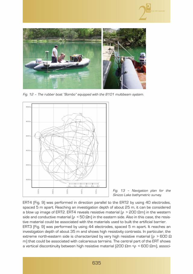
ERT4 (Fig. 9) was performed in direction parallel to the ERT2 by using 40 electrodes,spaced 5 m apart. Reaching an investigation depth of about 25 m, it can be considereda blow up image of ERT2. ERT4 reveals resistive material (ρ > 200 Ωm) in the westernside and conductive material (ρ < 50 Ωm) in the eastern side. Also in this case, the resis-tive material could be associated with the materials used to built the artificial barrier. ERT3 (Fig. 9) was performed by using 44 electrodes, spaced 5 m apart. It reaches aninvestigation depth of about 35 m and shows high resistivity contrasts. In particular, theextreme north-eastern side is characterized by very high resistive material (ρ > 600 Ωm) that could be associated with calcareous terrains. The central part of the ERT showsa vertical discontinuity between high resistive material (200 Ωm <ρ < 600 Ωm), associ-
635
Fig. 12 – The rubber boat “Bombo” equipped with the 8101 multibeam system.
Fig. 13 – Navigation plan for theSinizzo Lake bathymetric survey.
636
ated with the materials used to built the artificial barrier, and low resistive materials (ρ< 50 Ωm), associated with silts cropping out in the area. The ERT shows these low resis-tive materials also on the south-western side of the lake. ERT3 crosses all the other ERTs, as shown in figure 9 by the blue arrows. The compar-ison between all the performed ERTs helps to better define the geological setting of theSinizzo lake. In particular, surficial materials in the southern area of the Sinizzo Lakeappears to be relatively less competent. This is consistent with surficial observations ofsilts in this zone. The other areas around the lake are constituted by more competentmaterial, as conglomerates and alluvial terrains.The ERTs interpretation highlights vertical and horizontal discontinuities in the stratig-raphy and provides estimate of the thickness of the materials within the artificial barrieron the western side of the lake. Moreover, the ERTs provide information on the integrityof the western edge of the lake; it seems that the cracks involving this edge involve onlythe surface materials, since the ERTs do not highlight the presence of cracks at depth.
4.2 Swath BathymetryHigh-resolution multi-beam bathymetry of Lake Sinizzo (Figs. 10 and 11) was performedon 8 May 2009, 32 days following the main shock. The multi-beam system was equippedwith a transducer head with operating frequency of 240 kHz, a processing unit (PU), agyrocompass and a Dynamic Motion Sensor (TSS). Both heading and attitude data wereacquired via a MAHRS inertial navigation system, manufactured by Teledyne. Positioningwas obtained through a Topcon GPS equipped with a RTK system. All the instrumentswere interfaced with the PDS 2000 software package used for survey planning, dataacquisition and processing.Multi-beam bathymetric data were collected from a rubber boat equipped with a dedi-cated pole and flange used to operate the sonar head (Fig. 12). Vessel tracks were posi-tioned so as to insonify 100 percent of the lake floor, with significant overlap (Fig. 13).Patch test to determine and correct biases from positioning time delay (latency), pitchoffset, azimuthal (yaw) offset and roll offset were performed after system installation inaccordance with standard procedures. Multi-beam data were edited to eliminate spuriousbathymetric and navigation points, and processed using PDS 2000 software from Reson.Subsequently, the processed data were used to generate a digital elevation model (DEM)with cell size of 5 cm x 5 cm, with an accuracy meeting the requirements of the Interna-tional Hydrographic Organization (IHO). The collected data revealed morphological features of the lake floor, at metre anddecimetre-scale, including features related to slope instability. Overall, the lake is about10 m deep (9,99m), circular in shape, and with a mean diameter of 120.7 m (Fig. 10,Table 1). The lake bottom is nearly flat, with an asymmetric east-west profile, a concavewestern slope and a gentle morphologic step along the eastern side (Fig. 14). Hazard-related morphologies include centimetric waves and lobes probably connected to a veryshallow creeping of the western slope, arcuate forms, linear depressions, fissures andsteps indicating incipient slope instabilities (Fig. 15). A comparison of the new swath bathymetry data with an existing single-beam bathym-etry (Fig. 16; TETÈ et alii, 1984) did not reveal any significant difference in the general lake-floor configuration and relative depth distribution. The most relevant feature is an incip-
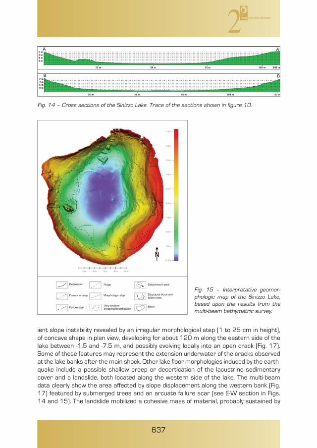
ient slope instability revealed by an irregular morphological step (1 to 25 cm in height),of concave shape in plan view, developing for about 120 m along the eastern side of thelake between -1.5 and -7.5 m, and possibly evolving locally into an open crack (Fig. 17).Some of these features may represent the extension underwater of the cracks observedat the lake banks after the main shock. Other lake-floor morphologies induced by the earth-quake include a possible shallow creep or decortication of the lacustrine sedimentarycover and a landslide, both located along the western side of the lake. The multi-beamdata clearly show the area affected by slope displacement along the western bank (Fig.17) featured by submerged trees and an arcuate failure scar (see E-W section in Figs.14 and 15). The landslide mobilized a cohesive mass of material, probably sustained by
637
Fig. 14 – Cross sections of the Sinizzo Lake. Trace of the sections shown in figure 10.
Fig. 15 – Interpretative geomor-phologic map of the Sinizzo Lake,based upon the results from themulti-beam bathymetric survey.

tree roots and internal cementation, with a total volume of 431.6 m3. The available dataalso indicate that the displaced block induced a deformation of the lake sedimentary coveroccurring at the lake bottom.The significant similarity between the previous single-beam bathymetry and the new multi-beam data (Fig. 16; Table 1) suggests a highly localized character of the earthquake-induced effects, almost exclusively confined at the lake banks. Scarce underwaterevidence for the widespread cracking and fissuring observed above-water, and lack of well-developed ground deformations at the lake floor indicate very superficial, not evolvedtoppling of the lakeshore. Nevertheless, minor vertical displacement observed locally,along with volume increase of the lake basin (Table 1) may indicate that, after the mainshock, minor “sinking“ movements affected the lake.
5. CONCLUSIONS
The geophysical surveys carried out at the Sinizzo Lake after the 6 April 2009 earthquakeprovided information on the effects induced by the seismic shocks in the sinkhole areaand its immediate surroundings. Development of an extensive network of cracks aroundthe lake shores, in particular, pushed to investigate the likely continuation of thesefeatures at depth, and the occurrence of mass movements as well. Results from boththe electrical resistivity tomography and the lake bathymetry indicated that the cracksseem to involve only the Quaternary deposits at shallow depths. Some individual slideswere identified, the most striking of which occurred on the western shore of the lake.However, no indications of deeper mass instabilities, or problems related to integrity ofthe impounding embankment, were observed. This is supported by the overall consistencybetween the 2009 swath bathymetry and that previously obtained in 1984 with a single-beam technique.In regard to the sinkhole origin, in order to ascertain whether the Sinizzo Lake originatedas a result of a collapse or of a slower process (e.g., suffosion-type) further analyses areneeded to reconstruct in greater detail the overburden thickness. In the first case, given
638
Fig. 16 – Bathymetry of Sinizzo Lake: left, single-beam bathymetry, as surveyed in the 1980’s (afterTetè et alii, 1984); right, swath bathymetry data, as surveyed on May 8, 2009.
639
the nature of the cover deposits, the collapse may have been originated in voids withinthe soluble bedrock below, with upward propagation until reaching the ground surface.However, it has to be noted that the overall morphology of the lakeshore may indicate thelikely possibility of a suffosion-type sinkhole (WALTHAM et alii, 2005), related to downwardtransport of material into the network of fissures and joints in the limestone bedrock.
ACKNOWLEDGEMENTS
Multi-beam data were acquired and processed with the help of Geomarine S.r.l., Senigallia.We thank Paolo Scotto di Vettimo (CNR-IAMC) for his help during MBES system installa-
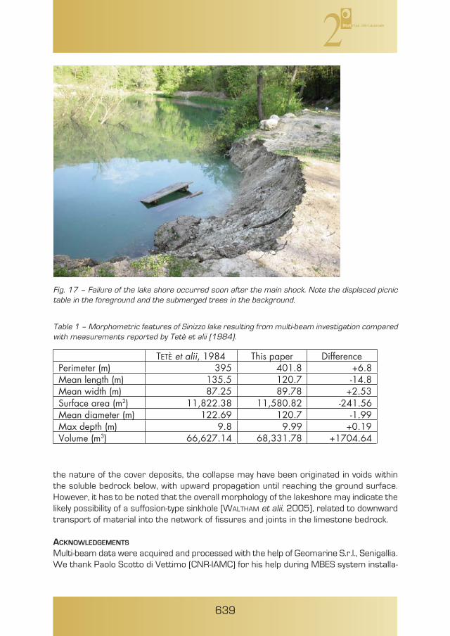
Fig. 17 – Failure of the lake shore occurred soon after the main shock. Note the displaced picnictable in the foreground and the submerged trees in the background.
TETÈ et alii, 1984 This paper Difference8.6+8.104593)m( retemireP
Mean length (m) 135.5 120.7 -14.8Mean width (m) 87.25 89.78 +2.53Surface area (m2) 11,822.38 11,580.82 -241.56Mean diameter (m) 122.69 120.7 -1.99
91.0+99.98.9)m( htped xaMVolume (m3) 66,627.14 68,331.78 +1704.64
Table 1 – Morphometric features of Sinizzo lake resulting from multi-beam investigation comparedwith measurements reported by Tetè et alii (1984).

tion; Alessandro Giocoli and Giuseppe Calamita, CNR IMAA, for the technical supportduring the geo-electrical acquisition; Patricia Sclafani, CNR IAMC, for proofreading of theEnglish manuscript.
REFERENCES
ALMAGIÀ R. (1919) – Alcuni fenomeni carsici nell’Abruzzo aquilano. Bollettino della SocietàGeografica Italiana, 9, 937-955.
ACCORDI G., CARBONE F., PAROTTO M., PRATURLON A., CIVITELLI G., CORDA L., DE RITA D., ESU D.,FUNICIELLO R., KOTSAKIS T., MARIOTTI G. & SPOSATO A. (1988) – Carta delle litofacies delLazio-Abruzzo ed aree limitrofe. CNR, Prog. Fin. Geodinamica, Quaderni della RicercaScientifica, 114, 223 pp.
BAGNAIA R., D’EPIFANIO A. & SYLOS SABINI S. (1989) – Aquilan and Subequan basins: anexample of Quaternary evolution in central Apennines, Italy. Quaternaria Nova, 2,187-209.
BERTINI T., BOSI C. & GALADINI F. (1989) – La conca di Fossa – S. Demetrio de’ Vestini. In:CNR, Centro di Studio per la Geologia Tecnica, ENEA, Elementi di tettonica pliocenico-quaternaria ed indizi di sismicità olocenica nell’Appennino laziale-abruzzese. SocietàGeologica Italiana, 26-58.
BOSI C. & BERTINI T. (1970) – Geologia della media valle dell’Aterno. Memorie della SocietàGeologica Italiana, 9, 719-777.
BLUMETTI A.M., CAVINATO G.P. & TALLINI M. (1996) – Evoluzione Plio-Quaternaria della concadi Aquila-Scoppito: studio preliminare. Il Quaternario, 9 (1), 281-286.
CAVINATO G.P. & DE CELLES P.G. (1999) – Extensional basins in the tectonically bimodalcentral Apennines fold-thrust belt, Italy: response to corner flow above a subductingslab in retrograde motion. Geology, 27, 955-958.
GEER ASSOCIATION (2009) – Preliminary report on the seismological and geotechnicalaspects of the April 6 2009 L’Aquila earthquake in central Italy. GEER Associationreport no. GEER-016.
KEEFER D.K. (1984) – Landslides caused by earthquakes. Geol. Soc. America Bulletin, 95,406-421.
MARINI G. (1976) – Il fenomeno carsico nella conca dell’Aquila. Quad. Museo SpeleologicoV. Rivera, 1 (3), 41-56.
MC CALPIN J.P. & NELSON A.R. (1996) – Introduction to paleoseismology. In: MC CALPIN J.P.(ed.) Paleoseismology. Academic Press, San Diego, 1-28.
MELETTI C., PATACCA E. & SCANDONE P. (2000) – Construction of a seismotectonic model:the case of Italy. Pure and Applied Geophysics, 157, 11-35.
NISIO S. (2008) – I sinkholes in Abruzzo. Mem. Desc. Carta Geol. d’Italia, 85, 269-308.PARISE M. (2008) - Rock failures in karst. In: CHENG Z., ZHANG J., LI Z., WU F. & HO K. (a cura
di), Landslides and Engineered Slopes. Proc. 10th Int. Symp. Landslides, Xi’an (China),June 30 – July 4, 2008, 1, 275-280.
PATACCA E., SCANDONE P., DI LUZIO E., CAVINATO G.P. & PAROTTO M. (2008) – Structural archi-tecture of the Central Apennines: interpretation of the CROP 11 seismic profile fromthe Adriatic coast to the orographic divide. Tectonics, 27 (3), doi:10.1029/2005TC001917.
TETÈ P., PESCE G.L. & LEONARDIS B. (1984) – Il lago Sinizzo nei pressi di San Demetrio ne’Vestini (L’Aquila). Natura, 74, 195-206.
640

TONDI E. & CELLO G. (2003) – Spatio-temporal evolution of the Central Apennines faultsystem (Italy). Journal of Geodynamics, 36, 113-128.
WALTHAM T. & LU Z. (2007) - Natural and anthropogenic rock collapse over open caves.In: PARISE M. & GUNN J. (Eds.), Natural and anthropogenic hazards in karst areas:recognition, analysis, and mitigation. Geological Society of London, sp. publ., 279, 13-21.
WALTHAM T., BELL F. & CULSHAW M. (2005) – Sinkholes and subsidence. Springer, PraxisPublishing, 382 pp.
YULE D.E. & GRAU T.H. (2003) – Earthquake event report for the North Alabama 29 April2003 Mw = 4.6 earthquake. Engineer Research and Development Center, Geotech-nical and Structures Laboratory, 21 pp.
641