Parte I - Presentazione complessiva del progetto · Parte I - Presentazione complessiva del...
54
MINISTERO DELL'ISTRUZIONE, DELL'UNIVERSITÀ E DELLA RICERCA Dipartimento per la Programmazione il Coordinamento e gli Affari Economici Servizio per lo sviluppo e il Potenziamento delle Attività di ricerca (SSPAR) FIRB 2003 D.D. 2186-Ric 12 dicembre 2003 Protocollo: RBNE037EJJ Programma Strategico Human, economical and social sciences Progetto Obiettivo The Euromediterranean cooperation Risultati attesi Methods and advanced technologies for the study and the valorisation of the ancient archeological and monumental heritage of the Mediterranean area Code: RBNE037EJJ Parte I - Presentazione complessiva del progetto 1.0 Ambito Programma Strategico Scienze umane, economiche e sociali Progetto Obiettivo La cooperazione euromediterranea 1.0.a Risultati attesi Metodologie e tecnologie avanzate per la conoscenza e la valorizzazione del patrimonio archeologico e monumentale dell'area mediterranea 1.1 Titolo del Progetto di Ricerca RECONSTRUCTION OF ARCHAEOLOGICAL LANDSCAPES IN MEDITERRANEAN COASTAL ENVIRONMENT VIA INNOVATED NON-INVASIVE THECNOLOGIES
Transcript of Parte I - Presentazione complessiva del progetto · Parte I - Presentazione complessiva del...

MINISTERO DELL'ISTRUZIONE, DELL'UNIVERSITÀ E DELLA RICERCA
Dipartimento per la Programmazione il Coordinamento e gli Affari Economici Servizio per lo sviluppo e il Potenziamento delle Attività di ricerca (SSPAR)
FIRB 2003 D.D. 2186-Ric 12 dicembre 2003
Protocollo: RBNE037EJJ
Programma Strategico
Human, economical and social sciences
Progetto Obiettivo
The Euromediterranean cooperation
Risultati attesi Methods and advanced technologies for the study and the valorisation of the ancient archeological and monumental heritage of the Mediterranean area
Code: RBNE037EJJ
Parte I - Presentazione complessiva del progetto 1.0 Ambito
Programma Strategico Scienze umane, economiche e sociali
Progetto Obiettivo La cooperazione euromediterranea
1.0.a Risultati attesi Metodologie e tecnologie avanzate per la conoscenza e la valorizzazione del patrimonio archeologico e monumentale dell'area mediterranea 1.1 Titolo del Progetto di Ricerca RECONSTRUCTION OF ARCHAEOLOGICAL LANDSCAPES IN MEDITERRANEAN COASTAL ENVIRONMENT VIA INNOVATED NON-INVASIVE THECNOLOGIES

Coordinatore scientifico della ricerca RANIERI Gaetano Professore Ordinario Università degli Studi di CAGLIARI 1.2 Abstract del Progetto di Ricerca The archaeological prospection and excavation of an ancient settlement is a slow, careful and consequently costly operation. Often times, and particularly in the Mediterranean region, city were built next to the coastline, in order to provide bases for trade along the most convenient pathway of the time - the sea. Subsequent relative motion of land and sea, and the enhanced erosion and sedimentation caused by wind and sea, caused these cities to be buried or sunk into the sea, almost invariably together with their harbours. Therefore, prospection of such sites is particularly difficult and slow. The need arises for a comprehensive prospection , that can delineate the areas of further direct investigations. In this research project, we propose a methodology based on a sequence of steps, starting from a refined analysis of satellite, remote and small scale aerial photographs, in order to define the prospection on land and at sea, via progressively selective and advanced non invasive, geophysical techniques. We will apply (a) stripping techniques to the shallowest non productive layer via filtering of the aerial photographs; (b) magnetic and electromagnetic methods, by adapting sensors to the use in shallow waters; (c) 2D and 3D electric tomographies, enhanced both in the field practice by using continuous towing, and in the data inversion; (d) single-channel seismic sections using a light sparker (400J), and side scan sonar views. The final outcome will be a digital 3D representation of the subsurface, that will help define candidate excavation areas, and will have at the same time an intrinsic cultural and touristic value before the full site excavation. Four sites of archaeological interest will be investigated: the Phoenician city of Neapolis, in the southern gulf of Oristano, Sardinia; the Roman city of Pollentia in the Island of Majorca, Spain; Peristeria and Kyparissia, the cities and funerary structures of Messenian period in the Olympia district, Peloponnesos, Greece; the harbour structure of Lixus, Morocco and the underwater structures of Cartago, Tunisia. 1.3 Parole chiave 1. REMOTE SENSING 2. IMAGE PROCESSING 3. GEOPHYSICAL METHODS 4. SCIENTIFIC VISUALISATION 5. ARCHAEOLOGICAL SITE ENHANCEMENT 6. COASTAL ARCHAEOLOGY

1.10 Elenco delle Unità di Ricerca (UR) nº Responsabile
scientifico Qualifica Istituzione Dip/Ist/Div/Sez Mesi/uomo
1. RANIERI Gaetano
Professore Ordinario
Università degli Studi di CAGLIARI
Dip. INGEGNERIA DEL TERRITORIO
112
2. COSENTINO Pietro Lucio
Professore Ordinario
Università degli Studi di PALERMO
Dip. CHIMICA E FISICA DELLA TERRA ED APPLICAZIONI ALLE GEORISORSE ED AI RISCHI NATURALI
113
3. GODIO Alberto
Ricercatore Universitario
Politecnico di TORINO Dip. GEORISORSE E TERRITORIO
107
4. FARANDA Francesco Maria
Coordinatore unità CoNISMa
CONSORZIO NAZIONALE INTERUNIVERSITARIO PER LE SCIENZE DEL MARE (CONISMA)
Unità Locale di Ricerca Univ. Milano-Bicocca
95
TOTALE 427 1.4 Informazioni generali
1.4.1 Durata del Progetto di Ricerca 36
1.4.2 Mesi uomo complessivi dedicati al Progetto di Ricerca 427
1.4.3 Costo totale del Progetto (KEuro) 1634
1.4.4 Finanziamento richiesto (KEuro) 1010
1.4.5 Numero di contratti triennali per giovani ric ercatori 5
Costo totale (KEuro) 192
1.4.6 Numero di contratti triennali per ricercatori di chiara fama 0
Costo totale (KEuro) 0
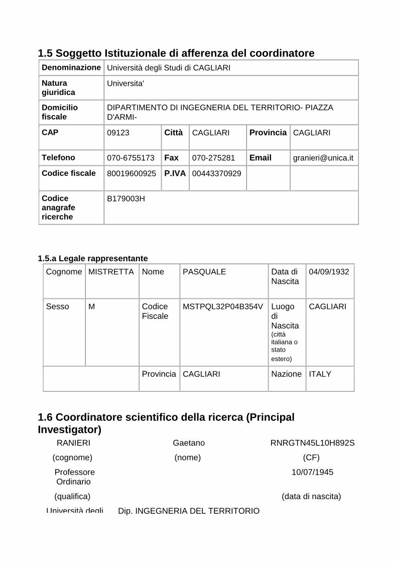
1.5 Soggetto Istituzionale di afferenza del coordin atore
Denominazione Università degli Studi di CAGLIARI
Natura giuridica
Universita'
Domicilio fiscale
DIPARTIMENTO DI INGEGNERIA DEL TERRITORIO- PIAZZA D'ARMI-
CAP 09123 Città
CAGLIARI Provincia
CAGLIARI
Telefono 070-6755173 Fax 070-275281 Email [email protected]
Codice fiscale 80019600925 P.IVA
00443370929
Codice anagrafe ricerche
B179003H
1.5.a Legale rappresentante
Cognome
MISTRETTA Nome PASQUALE Data di Nascita
04/09/1932
Sesso M Codice Fiscale
MSTPQL32P04B354V Luogo di Nascita (città italiana o stato estero)
CAGLIARI
Provincia
CAGLIARI Nazione
ITALY
1.6 Coordinatore scientifico della ricerca (Princip al Investigator)
RANIERI Gaetano RNRGTN45L10H892S
(cognome) (nome) (CF)
Professore Ordinario
10/07/1945
(qualifica) (data di nascita)
Università degli Dip. INGEGNERIA DEL TERRITORIO
Studi di CAGLIARI
(Istituzione di appartenenza) (art.5, c.1, DM
citato)
(Dipartimento/Istituto/Divisione/Settore)
(posizione)
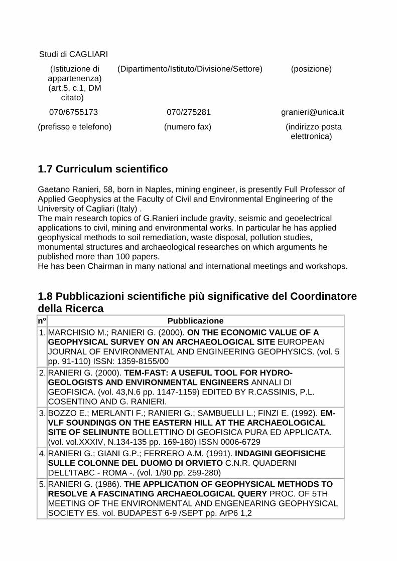
070/6755173 070/275281 [email protected]
(prefisso e telefono)
(numero fax) (indirizzo posta elettronica)
1.7 Curriculum scientifico Gaetano Ranieri, 58, born in Naples, mining engineer, is presently Full Professor of Applied Geophysics at the Faculty of Civil and Environmental Engineering of the University of Cagliari (Italy) . The main research topics of G.Ranieri include gravity, seismic and geoelectrical applications to civil, mining and environmental works. In particular he has applied geophysical methods to soil remediation, waste disposal, pollution studies, monumental structures and archaeological researches on which arguments he published more than 100 papers. He has been Chairman in many national and international meetings and workshops. 1.8 Pubblicazioni scientifiche più significative de l Coordinatore della Ricerca nº Pubblicazione 1. MARCHISIO M.; RANIERI G. (2000). ON THE ECONOMIC VALUE OF A
GEOPHYSICAL SURVEY ON AN ARCHAEOLOGICAL SITE EUROPEAN JOURNAL OF ENVIRONMENTAL AND ENGINEERING GEOPHYSICS. (vol. 5 pp. 91-110) ISSN: 1359-8155/00
2. RANIERI G. (2000). TEM-FAST: A USEFUL TOOL FOR HYDRO-GEOLOGISTS AND ENVIRONMENTAL ENGINEERS ANNALI DI GEOFISICA. (vol. 43,N.6 pp. 1147-1159) EDITED BY R.CASSINIS, P.L. COSENTINO AND G. RANIERI.
3. BOZZO E.; MERLANTI F.; RANIERI G.; SAMBUELLI L.; FINZI E. (1992). EM-VLF SOUNDINGS ON THE EASTERN HILL AT THE ARCHAEOLOG ICAL SITE OF SELINUNTE BOLLETTINO DI GEOFISICA PURA ED APPLICATA. (vol. vol.XXXIV, N.134-135 pp. 169-180) ISSN 0006-6729
4. RANIERI G.; GIANI G.P.; FERRERO A.M. (1991). INDAGINI GEOFISICHE SULLE COLONNE DEL DUOMO DI ORVIETO C.N.R. QUADERNI DELL'ITABC - ROMA -. (vol. 1/90 pp. 259-280)
5. RANIERI G. (1986). THE APPLICATION OF GEOPHYSICAL METHODS TO RESOLVE A FASCINATING ARCHAEOLOGICAL QUERY PROC. OF 5TH MEETING OF THE ENVIRONMENTAL AND ENGENEARING GEOPHYSICAL SOCIETY ES. vol. BUDAPEST 6-9 /SEPT pp. ArP6 1,2
1.9 Titoli scientifici più significativi del Coordi natore della Ricerca 1994-1995 COORDINATOR OF A NATIONAL PROJECT ON "Application of geophysical methods to soil protection. Special project on Piedmont disaster" (4 reearch teams). 1996-1997 COORDINATOR OF A NATIONAL PROJECT ON "Use of high resolution geophysical methods to solve geo-environmental problems" (9 research teams) 2000-2001 COORDINATOR OF A NATIONAL PROJECT ON "Non-invasive surveys for the preservation of monumental and archaeological structures. (4 research teams). 2003-2004 COORDINATOR OF A NATIONAL PROJECT ON "Optimisation of micro-geophysical methods in the vulnerability study of old buildings in historic towns" (4 research teams). CHAIRMAN AND EDITOR IN CHIEF of the First International Meeting of the Environmental and Engineering Geophysical Society - european section- TURIN 1995. DIRECTOR of the School on Soil and Environment Protection (1988-1990), COORDINATOR of the PhD course on Environmental Engineering (1988-1998)HEAD of the Department of Georesources and Land at Politecnico of Turin (1991-1995. H MEMBER of the Scientific Comittee of Italian Geophysical Group, CONSULTANT of Italian Ministry of Industries for the geothermal research CO-DIRECTOR of 10th Course of International School of Applied Geophysics at E.Maiorana Center in Erice (Italy). 2001-LEADER OF RESEARCH TEAM on "geophysics for archaeological research in Pylos and Chora-GREECE, granted by the Ministry of Scientific Research. 2002 LEADER OF RESEARCH TEAM on "micro-geophysics methods applied in archaeological research in shallow water" ITALY-GEORGIA(USA) PROJECT, granted by the Ministry of Scientific Research. 2001 LEADER OF RESEARCH TEAM on "geotechnical characterisation of the urban area of Barcelona ITALY-SPAIN PROJECT, granted by the Ministry of Scientific Research. 2001-2002: LEADER of italian research group of bilateral project ITALY-SPAIN on salt water intrusion in coastal aquifers. 1998-2000 COMPONENT OF LOCAL RESEARCH TEAM on FEDER PROGRESS PROJECT GRANTED BY EUROPEAN UNION. 2002-2003 LEADER OF SCIENTIFIC MISSION "Geophysical research to locate the theater of Volubilis (Morocco), Ministry of Foreign Affairs. 1997-1998: LEADER OF SCIENTIFIC MISSION "CHaracterisation of terrain in seismic zones of Cochabamba - Bolivia" , granted by Regional government of Sardinia 1997 e 1998: 1997-1998: LEADER OF SCIENTIFIC MISSION "geothermal research in the area of Boku, Main Ethiopian Rift Valley", granted by Regional Government of Sardinia. 2002: LEADER OF SCIENTIFIC MISSION "Localisation of underground structure between the Churches of Lalibela- Ethiopia", granted by Regional government of Sardinia 2001: LEADER OF SCIENTIFIC MISSION "Localisation of the Theater structures in Volubilis (Morocco)" , granted by Regional government of Sardinia 2000:LEADER OF SCIENTIFIC MISSION "Salt water intrusion and pollution study in the coastal plane of Tanger and Tetouan (Morocco)" , granted by Regional government
of Sardinia 2003-2004: LEADER OF SCIENTIFIC MISSION "Methods for the groundwater research and disinfection of waters for aquaculture in Egypt", granted by Regional government of Sardinia 2003-2004: LEADER OF SCIENTIFIC MISSION "Water mamagement in the coastal areas of Fortaleza, Brasil", granted by Regional government of Sardinia 2002-2005 : SUB-CONTRACTOR for INCO "SWIMED" project "Salt water intrusion, granted by E.U. FROM 1974 to 1998 LEADER OF RESEARCH TEAM on different arguments in the field of Civil and Environmental Engineering, granted by Italian National Council. REFEREE of some papers for international REvues CHAIRMAN In many session of EEGS Meetings (Nantes, Barcelona,Prague, Aveiro, Budapest) and of GNGTS italian annual meetings. 1.10 Elenco delle Unità di Ricerca (UR)
nº Responsabile scientifico
Qualifica Posizione Istituzione Dip/Ist/Div/Sez Mesi/uomo
1. RANIERI Gaetano
Professore Ordinario
Università degli Studi di CAGLIARI
Dip. INGEGNERIA DEL TERRITORIO
112
2. COSENTINO Pietro Lucio
Professore Ordinario
Università degli Studi di PALERMO
Dip. CHIMICA E FISICA DELLA TERRA ED APPLICAZIONI ALLE GEORISORSE ED AI RISCHI NATURALI
113
3. GODIO Alberto
Ricercatore Universitario
Politecnico di TORINO Dip. GEORISORSE E TERRITORIO
107
4. FARANDA Francesco Maria
Coordinatore unità CoNISMa
Vice-Presidente
CONSORZIO NAZIONALE INTERUNIVERSITARIO PER LE SCIENZE DEL MARE (CONISMA)
Unità Locale di Ricerca Univ. Milano-Bicocca
95
TOTALE 427
1.11 Breve descrizione delle Unità di Ricerca The University of Cagliari research unit, as part of the local Engineering School, is made of permanent personnel with a long experience matured in the use of geophysical methods applied to different areas of engineering with particular regards to applications to environmental and cultural heritage problems. The preferred research area is the study of new methods, using operational research, prototype developments, and optimization of measurement schemes. The group is leader at a European level in terms of size, organization and efficiency. Important contributions come also from theoretical studies on information content. In this respect, the Cagliari research unit is supported by experts in computer science, telecommunication and image processing. This research unit will also, for specific operations, cooperate with companies born as spin-offs of the same research group. The Cagliari unit will be involved in all phases of the proposed research, but will focus particularly on (a) development of techniques for image analysis, and (b) on the geophysical side, development of continuous acquisition schemes for electrical and seismic methods, and adaptation of such techniques to shallow water operations. This unit has substantial experience matured abroad, where it has been successfully involved in archaeological surveys. Good relationships exist with researchers from Mediterranean Countries. The numerous existing scientific agreements already developed within the area of operation is a guarantee of success for the project. The University of Palermo research unit is part of the local Physical and Geological Science School. It is characterised by a large group of young professionals. Numerous doctoral students and contract researchers are the backbone of the group, and testify towards the strong teaching and training dedication of the unit, particularly in the areas of environmental and cultural heritage research. The specific research objectives of this unit are within the development of micro-geophysical methods. In the past similar activity has produced prototype realization and development of interpretation algorithms, with original software implementation. Radar and electrical methods are the focus of this activity. A particular attention is devoted to the development of three-dimensional electrical tomography. This unit will also be involved in activity 3 of this project, with attention to the adaptation of the results for the final user. The Polytechnic of Turin research unit is also structured around young scientists, and is one of the most active at a national level. The research activity has been steered towards several objectives, both practical (methods applicability in specific conditions, quality of derived information) and theoretical (inversion of magnetic and electromagnetic data, algorithms for AC current tomography). Links with other disciplines, such as computer science and electronics, are strongly pursued. The group has obtained remarkable results in all areas of application. In this project, its role will be to develop signal processing methods for magnetic and multi-frequency electromagnetic data. The aim will be a more refined interpretation and an efficient visualization of the digital data. This research unit will also participate to the final phase (activity 3), that is aimed at value-adding to the data via visualization before the excavation takes place. CoNISMa is the Italian National Inter-University Consortium for Marine Science, and is a legal entity to which participate 28 Italian universities. The consortium objectives are
(a) to promote and coordinate research, as well as applied and scientific activities, in the field of Marine Science by coordinating the partner universities with other entities such as research institutes, local government bodies and industry; (b) to promote the access of all interested parties to the constitution or access to international laboratories of Marine Science. More than 650 individual researchers are affiliated to CoNISMa, including professors, researchers and technicians. In the framework of this project, CoNISMa will activate two separate research sub-units: the first located at University of Milan-Bicocca, the second at University of Palermo. The Bicocca unit will take care of the development and implementation of light seismic methods in shallow marine waters. To this end, the group will be made of units of permanent personnel and one contract researcher employed full time for the project. The development of a prototype vessel for shallow water operations, equipped with CHIRP, Side Scan Sonar and Multibeam sonar, will take place in cooperation with CoNISMa central structure. The Palermo unit will be dedicated to the development of methods for satellite remote sensing aimed at (1) the definition of a Digital Terrain Model that covers both the land and shallow water area, and that will be the unified basis for data integration, both on land and at sea; (2) the preliminary identification of areas to be investigated.
Le Unità di Ricerca
Unità di Ricerca n. 1
1.1 Descrizione della struttura e dei compiti dell' Unità di Ricerca
This research unit will be organized around the following personnel, all in permanent positions: Prof. Gaetano Ranieri, Prof. Gian Piero Deidda, Prof. Daniele Giusto, Prof. Fabio Roli, Mr. Luigi Sollai, Mr. Luigi Noli, Mr. Giampiero Casti, Mr. Avelino Mario Sitzia, Mr. Gianni Uda, Mr. Maurizio Serci, Mr. Antonello Lai. External collaborators to this unit will be: · Dr. Enrico Pieroni, responsible for the Imaging and Numerical Geophysics area at CRS4 (Centro Ricerche della Sardegna), in Cagliari. · the company PRO.DIGI Sas, specialized in underwater exploration and digital representation of the marine environment; · the company DELFIS S.r.l., specialized in software production for dissemination of archaeological information; · the company So.In.Geo. Sas, specialized in geophysical and topographycal surveys. · Prof. Ettore Cardarelli, Università di Roma 1, expert in the inversion of tomographic data. This research unit will utilize the following geophysical instrumentation, already acquired: MGS 256 of GF Instrument resistivimeter (Czech Republic) with 256 electrodes; Syscal Pro resistivimeter produced by IRIS, Orleans (France) with 48 electrodes;

GEM mod.GSMP 30 Potassium Magnetometer (USA) ABEM Mark VI seismometer, Stockholm (Sweden). Such instrumentation will have to be extended, to allow for an integrated use between land and sea, by the following items: airborne IR instrumentation for near range investigation; 3D instrumentation for marine surveys in shallow waters; multiplexed channels for the parallel Syscal Pro resistivimeter, in order to bring it to at least 192 electrodes for tomographies in the water-edge. This research unit will take care specifically of the following aspects: 1) preliminary analysis of research sites, to be performed on the satellitary and aerial images, both at far and close range, with appropriate filtering algorithms. This research unit has already proven in the recent past the effectiveness of the a methodological sequence for the screening of areas of potential archaeological interest, upon which subsequent geophysical investigation can be carried out. Particular emphasys will be given to the integration of land and sea data, in order to help define the overall urbanistic structure of each site; 2) fast acquisition of electrical, seismic and magnetic data on land, this via the enhancement of the available geophysical instrumentation, and the development of prototypes. Quasi-continuous electrical acquisition protocols will be tested, using towed rotating galvanic contacts; towed systems for seismic velocity measurement and magnetic data acquisition will also be developed and tested. 3) instrument adaptation for continuous use in shallow marine waters, with particular attention to electrical and magnetic data, and integration with land data. New continuous acquisition methods will be tried at sea, with towing of electrode arrays, both at sea surface (with floats) and on sea bottom. For this phase, the collaborators with underwater experience will be needed. 4) 3D reconstruction of geophysical data, via the optimization of data interpolation procedures and the integration with photo analysis. The study will focus on different interpolation algorithms for electrical data (for apparent and true resistivity), magnetic data (field and field gradient), and seismic data (P wave velocity), with ensuing cross-validation. 5) Visualization of results for the site value-adding phase of the project. We plan to produce graphical outputs to be used in movies of the terrestrial and marine environment and of the possible excavations, integrated with the dynamic representation of digital data coming from electrical, magnetic and seismic acquisitions. Such graphical outputs will be a fundamental aid for the optimization of excavation efforts, and will be of direct use also for the non experts. As such, these images will be at the core of the site value-adding strategy. The final format will be standard, in order to be readily available and usable on CDs.
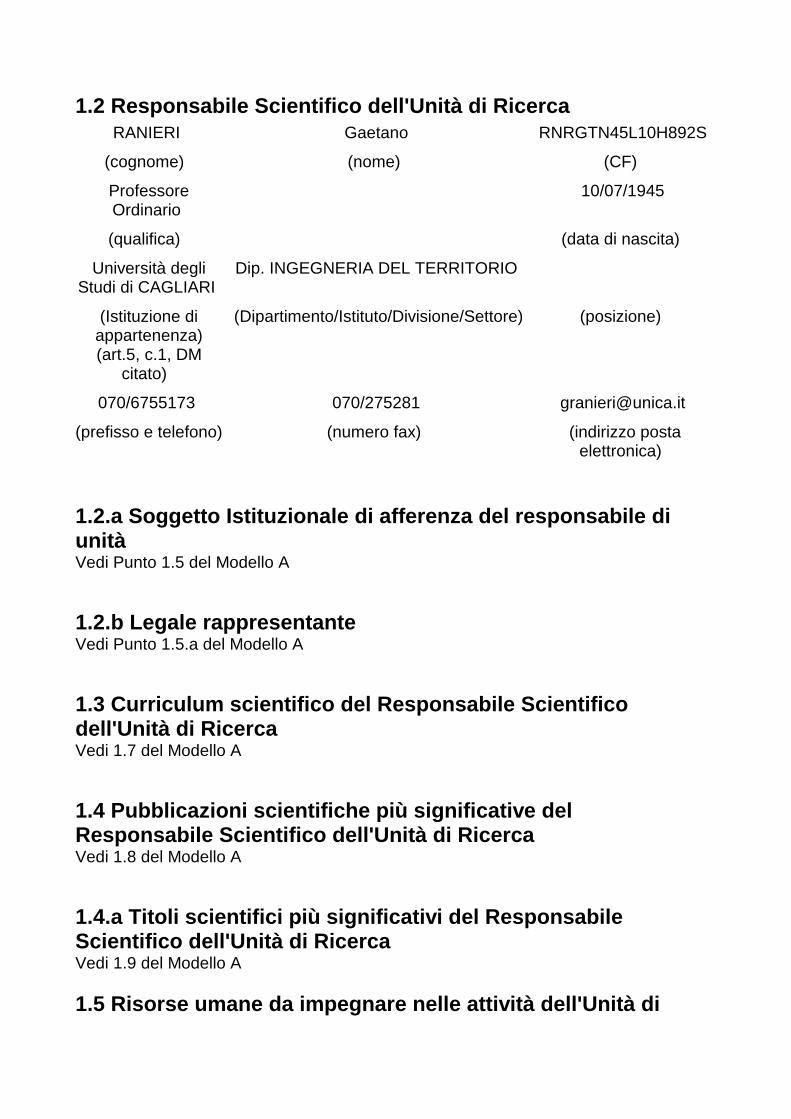
1.2 Responsabile Scientifico dell'Unità di Ricerca
RANIERI Gaetano RNRGTN45L10H892S
(cognome) (nome) (CF)
Professore Ordinario
10/07/1945
(qualifica) (data di nascita)
Università degli Studi di CAGLIARI
Dip. INGEGNERIA DEL TERRITORIO
(Istituzione di appartenenza) (art.5, c.1, DM
citato)
(Dipartimento/Istituto/Divisione/Settore)
(posizione)
070/6755173 070/275281 [email protected]
(prefisso e telefono)
(numero fax) (indirizzo posta elettronica)
1.2.a Soggetto Istituzionale di afferenza del respo nsabile di unità Vedi Punto 1.5 del Modello A 1.2.b Legale rappresentante Vedi Punto 1.5.a del Modello A 1.3 Curriculum scientifico del Responsabile Scienti fico dell'Unità di Ricerca Vedi 1.7 del Modello A 1.4 Pubblicazioni scientifiche più significative de l Responsabile Scientifico dell'Unità di Ricerca Vedi 1.8 del Modello A 1.4.a Titoli scientifici più significativi del Resp onsabile Scientifico dell'Unità di Ricerca Vedi 1.9 del Modello A 1.5 Risorse umane da impegnare nelle attività dell' Unità di

Ricerca
1.5.1 Personale della sede dell'Unità di Ricerca nº Cognome
Nome Università/Istituzione Dipartimento/Istituto Qualifica Mesi/uomo Costo
(k€) 1. DEIDDA
Gian Piero Università degli Studi di CAGLIARI
INGEGNERIA DEL TERRITORIO
Prof. Associato 3 6
2. GIUSTO Daniele
Università degli Studi di CAGLIARI
INGEGNERIA ELETTRICA ED ELETTRONICA
Prof. Ordinario 1 4
3. RANIERI Gaetano
Università degli Studi di CAGLIARI
INGEGNERIA DEL TERRITORIO
Prof. Ordinario 6 27
4. ROLI Fabio Università degli Studi di CAGLIARI
INGEGNERIA ELETTRICA ED ELETTRONICA
Prof. Ordinario 1 4
5. CASTI GIAMPIERO
Università degli Studi di CAGLIARI
INGEGNERIA DEL TERRITORIO
TECNICO D1/SQUADRA GEOFISICA
2 4
6. LAI ANTONIO
Università degli Studi di CAGLIARI
INGEGNERIA DEL TERRITORIO
TECNICO C3/SQUADRA GEOFISICA
2 4
7. NOLI LUIGI Università degli Studi di CAGLIARI
INGEGNERIA DEL TERRITORIO
TECNICO C3/SQUADRA GEOFISICA
2 4
8. SERCI MAURIZIO
Università degli Studi di CAGLIARI
INGEGNERIA DEL TERRITORIO
TECNICO C3/ASS.GEOFISICO
2 4
9. SITZIA AVELINO MARIO
Università degli Studi di CAGLIARI
INGEGNERIA DEL TERRITORIO
TECNICO C5/RIPRESE FOTOGRAFICHE
2 4
10. UDA GIANNI
Università degli Studi di CAGLIARI
INGEGNERIA DEL TERRITORIO
TECNICO C3/ASS.SUBACQUEO
1 2
11. DEIANA RITA
PALERMO GEOCHIMICA E FISICA DELL'AMBIENTE
Borsista 1 1
TOTALE 23 64 1.5.2.a Personale a contratto da destinare a questa specifica proposta progettuale
nº Qualifica Tipologia Mesi/uomo Costo (k€)
1. SOCIETA' DI INGEGNERIA , TOPOGRAFIA E GEOFISICA
Consulenza 2 8
2. SOCIETA' ESPERTA IN IMMERSIONI, RILIEVO E RIPRESE SUBACQUEE
Consulenza 5 20
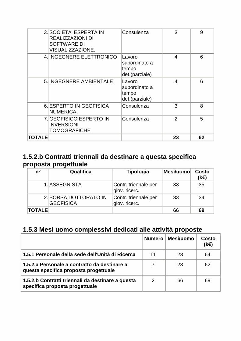
3. SOCIETA' ESPERTA IN REALIZZAZIONI DI SOFTWARE DI VISUALIZZAZIONE.
Consulenza 3 9
4. INGEGNERE ELETTRONICO Lavoro subordinato a tempo det.(parziale)
4 6
5. INGEGNERE AMBIENTALE Lavoro subordinato a tempo det.(parziale)
4 6
6. ESPERTO IN GEOFISICA NUMERICA
Consulenza 3 8
7. GEOFISICO ESPERTO IN INVERSIONI TOMOGRAFICHE
Consulenza 2 5
TOTALE 23 62 1.5.2.b Contratti triennali da destinare a questa s pecifica proposta progettuale
nº Qualifica Tipologia Mesi/uomo Costo (k€)
1. ASSEGNISTA Contr. triennale per giov. ricerc.
33 35
2. BORSA DOTTORATO IN GEOFISICA
Contr. triennale per giov. ricerc.
33 34
TOTALE 66 69 1.5.3 Mesi uomo complessivi dedicati alle attività proposte
Numero Mesi/uomo Costo (k€)
1.5.1 Personale della sede dell'Unità di Ricerca 11 23 64
1.5.2.a Personale a contratto da destinare a questa specifica proposta progettuale
7 23 62
1.5.2.b Contratti triennali da destinare a questa specifica proposta progettuale
2 66 69
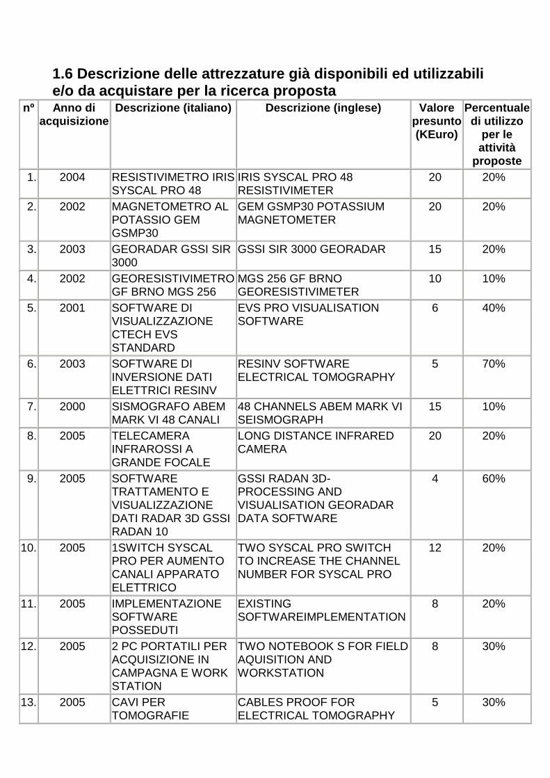
1.6 Descrizione delle attrezzature già disponibili ed utilizzabili e/o da acquistare per la ricerca proposta
nº Anno di acquisizione
Descrizione (italiano) Descrizione (inglese) Valore presunto (KEuro)
Percentuale di utilizzo
per le attività
proposte 1. 2004 RESISTIVIMETRO IRIS
SYSCAL PRO 48 IRIS SYSCAL PRO 48 RESISTIVIMETER
20 20%
2. 2002 MAGNETOMETRO AL POTASSIO GEM GSMP30
GEM GSMP30 POTASSIUM MAGNETOMETER
20 20%
3. 2003 GEORADAR GSSI SIR 3000
GSSI SIR 3000 GEORADAR 15 20%
4. 2002 GEORESISTIVIMETRO GF BRNO MGS 256
MGS 256 GF BRNO GEORESISTIVIMETER
10 10%
5. 2001 SOFTWARE DI VISUALIZZAZIONE CTECH EVS STANDARD
EVS PRO VISUALISATION SOFTWARE
6 40%
6. 2003 SOFTWARE DI INVERSIONE DATI ELETTRICI RESINV
RESINV SOFTWARE ELECTRICAL TOMOGRAPHY
5 70%
7. 2000 SISMOGRAFO ABEM MARK VI 48 CANALI
48 CHANNELS ABEM MARK VI SEISMOGRAPH
15 10%
8. 2005 TELECAMERA INFRAROSSI A GRANDE FOCALE
LONG DISTANCE INFRARED CAMERA
20 20%
9. 2005 SOFTWARE TRATTAMENTO E VISUALIZZAZIONE DATI RADAR 3D GSSI RADAN 10
GSSI RADAN 3D- PROCESSING AND VISUALISATION GEORADAR DATA SOFTWARE
4 60%
10. 2005 1SWITCH SYSCAL PRO PER AUMENTO CANALI APPARATO ELETTRICO
TWO SYSCAL PRO SWITCH TO INCREASE THE CHANNEL NUMBER FOR SYSCAL PRO
12 20%
11. 2005 IMPLEMENTAZIONE SOFTWARE POSSEDUTI
EXISTING SOFTWAREIMPLEMENTATION
8 20%
12. 2005 2 PC PORTATILI PER ACQUISIZIONE IN CAMPAGNA E WORK STATION
TWO NOTEBOOK S FOR FIELD AQUISITION AND WORKSTATION
8 30%
13. 2005 CAVI PER TOMOGRAFIE
CABLES PROOF FOR ELECTRICAL TOMOGRAPHY
5 30%

ELETTRICHE E ACQUISIZIONE SISMICA IN ACQUA
AND SEISMIC AQUISITION
1.7 Spese complessive dell'Unità di Ricerca
Voce di spesa (DM. 199 Ric. del 08/03/01;
art.6, c.6)
Spesa (KEuro)
Note
Spese di personale (*)
126 L'IMPEGNO E' COMPUTATO PER I TRE ANNI. IL PERSONALE SARA' DIVISO IN SQUADRE PER I DIVERSI TIPI DI RILIEVO
Spese generali direttamente imputabili all'attività di ricerca nella misura forfettizzata del 60% del costo del personale (compreso quello relativo ai ricercatori)
117 SPESE VIAGGI E MISSIONI NEI QUATTRO SITI PRESCELTI, CON ATTREZZATURE E QUINDI TRASFERIMENTO ANCHE CON ADEGUATI MEZZI DI TRASPORTO DA NOLEGGIARE. ESSE SONO RIFERITE A VIAGGI PER RICOGNIZIONE, PER RILIEVI GEOFISICI(COMPLESSIVAMENTE PER 300 GIORNATE DI MISSIONE), PER RILIEVI TOPOGRAFICI (50 GIORNATE), PER ANALISI DEI DATI (300 GIORNATE), PER ACQUISIZIONE E ANALISI FOTO AEREE, PER ANALISI RILIEVO REMOTE E NEAR SENSING (100 GIORNATE), PER L'ADEGUAMENTO STRUMENTI PER L'USO IN CONTINUO SIA A TERRA CHE IN MARE (40 GIORNATE), PER MATERIALE FOTOGRAFICO, PER STAMPA, PER PAGINE WEB, PER RELAZIONI, TELEFONO, FAX, POSTALI E MINORI, PER ORGANIZZAZIONE WORKSHOP, PER IMPOSTAZIONE DI CENTRO DI STUDIO MEDITERRANEO TECNOLOGIE AVANZATE BENI CULTURALI, PER AMMINISTRAZIONE.
Spese per giovani ricercatori e ricercatori di chiara fama internazionale
69 E' PREVISTA L'ISTITUZIONE DI UNA BORSA TRIENNALE PER LA PARTECIPAZIONE AD UN DOTTORATO DI RICERCA E DI UN ASSEGNO DI RICERCA
Spese per l'acquisizione di attrezzature, limitatamente alle quote impiegate per lo svolgimento dell'attività oggetto del progetto
77 E' NECESSARIO UN AGGIORNAMENTO DEI SOFTWARE E DELLA STRUMENTAZIONE POSSEDUTI. CAMERA MULTISPETTRALE PER TELERIPRESE.
Spese per st ages e 20 CORSI DI FORMAZIONE, MISSIONI PER

missioni all'estero di ricercatori coinvolti nel progetto
RAPPORTI INTERNAZIONALI E PER MASTER E CONFERENZE IN DIVERSI AMBITI
Costo dei servizi di consulenza e simili utilizzati per l'attività di ricerca
62 SPESE PER CONSULENZA DI PROFESSIONISTI O SOCIETA' DI RICERCA NEL CAMPO DELLA INFORMATICA, DEL RILIEVO GEOFISICO, NELLA VISUALIZZAZIONE DATI E PER LE RIPRESE E L'ASSISTENZA AL RILIEVO SUBACQUEO
Altri costi di esercizio (ad es. costo dei materiali, delle forniture e dei prodotti analoghi) direttamente imputabili all'attività di ricerca
20 CARBURANTE, NOLI, ASSICURAZIONI, CARNET ATA
TOTALE 491 (*) = ricercatori, tecnici ed altro personale adibito all'attività di ricerca, dipendente dal soggetto proponente e/o in rapporto subordinato a termine e/o di collaborazione coordinata e continuativa, ivi inclusi dottorati, assegni di ricerca e le borse di studio che prevedevano attività di formazione attraverso la partecipazione al progetto. Incidenza (in %) del costo della UR sul costo total e della proposta progettuale 30%
Costo complessivo della Proposta Progettuale
A carico del MIUR
A carico del Proponente
TOTALE
Costo delle attività di ricerca 296 126 422
Costo dei contratti triennali (giovani ricercatori)
69 69
Costo dei contratti triennali (ricercatori di chiara fama)
0
Costo complessivo della Proposta Progettuale
365 126 491
1.8 Certifico la dichiarata disponibilità al cofina nziamento previsto: SI
Unità di Ricerca n. 2
1.1 Descrizione della struttura e dei compiti dell' Unità di Ricerca The work group of Palermo (at CFTA Department, Geophysical section) is composed by: P. L. Cosentino and S. Deganello Full Professors R. Martorana and V. Sanfratello, PhD, research contractors S. Pellerito P. Messina, G. Fiandaca, L. Romano, P. Capizzi, PhD students. The work group characterize it self also for the training job of young researchers, in which the coordinator has a long experience. The main instruments available at CFTA Department are: - Terraloc MK6 by ABEM with 48 channels, with many type of sources and detectors (geophone to refraction, reflection and, piezoelectric ); - Microresistivity system MRS-256 by GF Instruments (Czech Republic), with 256 acquisition channels; - Georadar SIR system 2 and SIR3000 by GSSI, with 40, 100, 200, 400 (2 antenna), 900, 1000, 1600 MHz antenna; - Electromagnetic system by Zonge with 6 channels, low frequency, in order to acquire TDEM measurements; - Thermocamera P40 by FLIR System high resolution; - Raggi X (Diffrattometry, Camere alle polveri e Camere a cristallo singolo); - SEM Instruments; - X-Ray fluorescence; - Optic microscopy (Axiomat, polarized and stereoscopic microscope); - Mass spettrometry. However, the instrumentation which will be used for this project is listed in the paragraph 1.6 of this sheets. The archaeological sites to be studied by geophysical methods are: - Forum of Lixus, in Mauretania Tingitana (Morocco); - Neapolis in Oristano (Italy); - Pollentia, in Alcudia, Maiorca island (Spain); - Bay of Voidoikilia (Greece); - Volimidhia (Greece); - Peristeria (Greece). In order to study these archaeological sites, the following geophysical measurements are proposed: - GPR - georadar reflection tomography (N.V.A.) with the restitution of pseudo-depth slices, - electric tomography, - magnetometric, - electromagnetometric, - TDEM measurements, - thermographic measurements. The aim of the research project is not only the location of archaeological remains which are buried in land and off shore, but also the optimization of the hardware and software

tools for a possible public presentation. In fact, the time laps ranging from the technical results and the excavation of the remains is generally large, and consequently a virtual representation of the geophysical results would be prepared and offered to the public authorities for the best enjoyment of the cultural heritage. The georadar is one of the newer techniques which is most frequently used for geophysical work in different fields. It can be, in fact, successfully used to detect geological structures, karst cavities, pipe lines, or carry out archaeological studies, also allowing any endeavor which may be aimed at discriminating shallow underground materials. Measurements will be carried out with two GSSI GPR systems, namely SIR System 2 and SIR 3000. The systems include a control unit and eight antennas. These have different frequencies: 40, 100, 200, 900, 1000,and 1600 MHz, respectively, with two of them operating, instead, at 400 MHz. The 400 MHz and 900 MHz antennas are best suited for the type of research here discussed and the depths which we plan to reach. In particular the 400 MHz antennas will allow us to acquire data bistatic modality, while those at 900 MHz provide better detail, even if at reduced depths. The "time slices” or “depth-slices” technique is used in many GPR applications to produce a graphic representation of profiles. This technique represents one of several ways of carrying out reflection tomography. The time slices technique will allow us to reconstruct through horizontal sections the planimetric behavior of the reflections that are produced by underground electromagnetic discontinuities. The time slices are proving highly valuable at detecting underground cavities and buried structures in general; they can render, in fact, the images of the shape of those bodies and of its geometrical variation with depth. By using a layout of profiles which are mutually perpendicular we will then be able to produce a grid, whose nodes will have a specific topographic reference. Construction of time slices will allow one to implement 3 D modeling thus facilitating the identification of the location of the principal anomalies detected. In addition each horizontal section will include signals which come from a depth interval integrated over 50 cm or 1 m and centered on the average value indicated in the map as reference depth. High resolution electric tomography will be carried out by a microresistivity system MRS-256 produced by GF Instruments (Checz Republic). This instrument allows to acquire 256 potential measurements together. Using an array of 256 electrodes spaced of 50 cm is possible to obtain tomographies of about 10 x 10 m, the investigation depth being of about 8 m. The data will be analysed using back-projection method and inversion technique (software RES2DINV and RES3DINV, by dr Loke). For field work we will use conventional copper and/or iron electrodes. For work in stone artifacts we instead projected to use special electrodes, similar to those used in medicine for ECG work (the internal resistance, typically, being of the order of 0.5-5 MOhm). This tomographic technique has been recently optimized in order to be used in a configuration which we call "resistivity grid". In the latter the potential electrodes are distributed along a squared grid while the current electrodes are located on the outside of the grid along one or more directions at different distances from each other. The ddp measurements between each pair of adjacent electrodes are computed, along directions parallel to that of the current dipole. Also in this case 3D imaging will be produced, in order to improve anomalies rendering and location. In addition, electric, magnetometric and electromagnetometric measurements will be acquired, using standard data processing and interpretation techniques. We projected to carry out a series of comparative analyses using TDEM and thermic

measurements, also acquired by other working group of this project. For TDEM acquisition the EM instrument Zonge - 6 channels and 3 kW transmitter - will be used. For thermic measurements we will use the Thermocamera FLIR system P40. Finally we propose to carry out a series of comparative analyses in our test laboratory using micro-geophysical measurements (electric and GPR) and structural analysis (microscopy) from the most interesting archaeological samples. To properly calibrate the GPR data we initially plan to systematize the findings using techniques of optical and electron microscopy [scanning (SEM) and transmission mode (TEM)]. These studies will be eventually complemented by powder x-ray diffraction work, using graphite-monochromatic CuKa radiation. In so doing we will not only be able to discriminate the individual mineralogical phases that are present in the samples but to determine their unit cells and crystal structure. This information will then critically characterize each sample together with any potential feedback from order-disorder work at atomic level and the results from compositional studies. These are to be carried out using, primarily, techniques of x-ray microanalysis [respectively, Energy Dispersive (EDS) and Wavelength Dispersive System (WDS)]. The determination of the unit cell parameters and crystal structures will be carried out using structure-refinement packages based on the Rietveld procedure. Alternatively, when appropriate, the structural work will be finalized using single-crystal studies. All the x-ray studies will be carried out using powder and four-circle single crystal diffractometers as well as Guinier and Gandolfi cameras. The EDS analyses will be instead carried out on a Oxford-Link platform 5431 using a Cambridge Stereosca 360 scanning electron microscope. For the WDS analyses we will, instead, use a Cameca-Camebax ion probe. 1.2 Responsabile Scientifico dell'Unità di Ricerca
COSENTINO Pietro Lucio CSNPTR41M30G273Q
(cognome) (nome) (CF)
Professore Ordinario
30/08/1941
(qualifica) (data di nascita)
Università degli Studi di
PALERMO
Dip. CHIMICA E FISICA DELLA TERRA ED APPLICAZIONI ALLE GEORISORSE
ED AI RISCHI NATURALI
(Istituzione di appartenenza) (art.5, c.1, DM
citato)
(Dipartimento/Istituto/Divisione/Settore) (posizione)
091/6169703 [email protected]
(prefisso e telefono)
(numero fax) (indirizzo posta elettronica)

1.2.a Soggetto Istituzionale di afferenza del respo nsabile di unità
Denominazione Università degli Studi di PALERMO Natura giuridica
Universita'
Domicilio fiscale
VIA ARCHIRAFI, 36 – 90123 PALERMO
CAP 90123 Città
PALERMO Provincia
PALERMO
Telefono 0916169703 Fax 0916177580 Email [email protected] Codice fiscale 80023730825 P.IVA
00605880822
Codice anagrafe ricerche
1.2.b Legale rappresentante
Cognome
VALENZA Nome MARIANO Data di Nascita
04/08/1947
Sesso M Codice Fiscale
VLNMRN47M04G511H Luogo di Nascita (città italiana o stato estero)
PETRALIA SOTTANA
Provincia
PALERMO Nazione ITALY
1.3 Curriculum scientifico del Responsabile Scienti fico dell'Unità di Ricerca Prof. Pietro Cosentino (born in Palermo il 30/08/1941) residing in Palermo, via XX Settembre 11. FORMATION ACTIVITY Regular Assistant from 1971 to 1982 Professor with a temporary appointment from 1974 to 1982 (Earth Physics and Mining Geophysics) Assoc. Prof. of Mining Geophysics from 1983 to 1987 Chair of Applied Geophysics from 1987 to today Teacher of Seismology from 1989 to today Chair of Environmental Geophysics from 2000 REASEARCH ACTIVITY Author of 93 papers (italian and international journals) MAIN RESEARCH FIELDS

- Applied Geophysics for Engineers and Environment using electric, seismic, magnetic and electromagnetic methods. - Seismic risk assessment - Crustal geophysics - Electromagnetic survey using low, medium and high frequencies (GPR). Main targets: Geological hazards evaluation, Study of precursor signs and monitoring of earthquakes and eruptions, Discovering and protection of natural resources, Environmental and engineering problems, Archaelogical researchs, Etc. 1.4 Pubblicazioni scientifiche più significative de l Responsabile Scientifico dell'Unità di Ricerca nº Pubblicazione 1. COSENTINO P.L.; MARTORANA R.; SANFRATELLO V. (2003). An approach
to the electrical tomography aimed to the investiga tion of particular confined structures 9th EEGS Meeting, Praga (CZ). pp. O-091
2. CAPIZZI P.; COSENTINO P.L.; ROMANO L. (2003). Polarization and acquisition in GPR surveys: tests on physical model s 9th EEGS Meeting, Praga (CZ). pp. O-045
3. COSENTINO P.L.; CAPIZZI P.; MARTORANA R.; MIRAGLIA D.; PELLERITO S.; SANFRATELLO V.; ANSELMO G.; GENOVESE C.; MESSINA P. (2002). Geophysical Researches in the Roman Villa del Casal e (Piazza Armerina, Sicily) 8th Meeting EEGS, Aveiro (PT). pp. 127-130
4. COSENTINO P.L.; MIRAGLIA D.; ROMANO L.; SCOPELLITI M. (2002). Non invasive controls of balcony corbels by means of GP R investigations 8th Meeting EEGS, Aveiro (PT). pp. 123-126
5. COSENTINO P.L. (2000). Approaching electrical tomography ANNALI DI GEOFISICA. (vol. 43, 6 pp. 1131-1146) ISSN: 1590-1815
1.4.a Titoli scientifici più significativi del Resp onsabile Scientifico dell'Unità di Ricerca Co-ordination of working group 1. Co-ordinator of Palermo U.O. in the program “CARATTERIZZAZIONE DI ROCCE E MANUFATTI CON METODI GEOFISICI” – 36 months, CNR – 1996-1999 (National Co-ordinatore: Prof. Marcello Bernabini, University of Roma) 2. Co-ordinator of Palermo U.O. in the program “INDAGINI NON INVASIVE PER LA CONSERVAZIONE DI STRUTTURE MONUMENTALI E ARCHEOLOGICHE” – 24 months MIUR - PROGRAMMI DI RICERCA ANNO 2000 (ex 40%) (National Co-ordinatore: Prof. Gaetano Ranieri, University of Cagliari) 3. Co-ordinator of the program: “STUDIO GEOFISICO DI STRUTTURE

MONUMENTALI CON L’UTILIZZAZIONE DI METODOLOGIE ELETTRICHE SISMICHE ED ELETTROMAGNETICHE” University of Palermo, 2000 (ex 60%). 4. Co-ordinator of the program: “RICERCHE SU MANUFATTI ARCHEOLOGICI ED ARCHITETTONICI CON METODI TOMOGRAFICI A CAMPI D’ONDA (SISMICA E RADAR) E DI POTENZIALE (TOMOGRAFIA ELETTRICA) PROGETTI DI COLLABORAZIONE SCIENTIFICA O DIDATTICA TRA L’UNIVERSITA’ DI PALERMO ED ATENEI, ISTITUTI E CENTRI DI RICERCA DI ALTRI PAESI” University of Palermo – University of Barcelona (Spain), 2000. 5. Co-ordinator of the program: “STUDIO MICROGEOFISICO DI MENSOLE LAPIDEE E DI ALTRE STRUTTURE AGGETTANTI CON L’UTILIZZAZIONE DI METODOLOGIE ELETTROMAGNETICHE (GEORADAR AD ALTA FREQUENZA)” University of Palermo, 2001 (ex 60%). 6. Co-ordinator of the program: “POTENZIAMENTO DEL SISTEMA INFORMATIVO METEOIDROPLUVIOMETRICO: REALIZZAZIONE DELLA RETE FREATIMETRICA AD INTEGRAZIONE DELLE RETI DI RILEVAMENTO E SORVEGLIANZA IN TELEMISURA” Community enterprise POR 2000-2006 (Asse I – Sottomisura 1.1.2.B.) 2002. Sycily Region Partner, Servizio Tecnico Idrografico (Fse). 7. Co-ordinator of the program: “STUDIO MICROGEOFISICO DI MENSOLE LAPIDEE E DI ALTRE STRUTTURE AGGETTANTI CON L’UTILIZZAZIONE DI METODOLOGIE ELETTROMAGNETICHE (GEORADAR AD ALTA FREQUENZA)” University of Palermo, 2002 (ex 60%). 8. Co-ordinator of the program: “SECHERESSE ET DESERTIFICATION DANS LE BASSIN MEDITERRANEE”. Interreg III B Medocc project Asse 4, Misura 4, 2003. Sycily Region Partner, Servizio Tecnico Idrografico (Fse). 9. Co-ordinator of Palermo U.O. in the program “DIAGNOSTICA CON METODOLOGIE TOMOGRAFICHE (ELETTRICHE ED A CAMPI D’ONDA) PER LO STUDIO DELLA VULNERABILITÀ DI MANUFATTI ED EDIFICI” – 24 months. MIUR - PROGRAMMI DI RICERCA ANNO 2003 (ex 40%) (National Co-ordinatore: Prof. Gaetano Ranieri, University of Cagliari) Organization of Meetings, Congress, Workshops, National and International Courses, etc. 1. Workshop: “… A trent’anni dal terremoto”. Partanna (TP), 10 January 1998 2. 17° Annual Congress of “Gruppo Nazionale di Geof isica della Terra Solida”, 10-12 November 1998. 3. Workshop Cultural Heritage: “Contributi delle discipline scientifiche, Palermo, 24-26 Giugno 1999. 4. International Conference on Earthquake Hazard and Risk in the Mediterranean Region Near East University, Nicosia, North Cyprus, 18-22 October 1999. 5. 18° Annual Congress of “Gruppo Nazionale di Geof isica della Terra Solida”, 9-11 November 1999. 6. Workshop: “La Fisica per i Beni Culturali”, in the 2000 CONGRESS of Physic Italian Society (LXXXVI Congresso Nazionale), Palermo, 9 october 2000. 7. 19° Annual Congress of “Gruppo Nazionale di Geof isica della Terra Solida”, 7-9 November 2000. 8. INTERNATIONAL SCHOOL OF APPLIED GEOPHYSICS 10th Course: Development of geophysical methods - application to shallow targets, ERICE , 7-12 Marzo 2000. 9. Course for “Esperti di Geofisica per l’Archeologia”, 692 hours, Palermo, april-
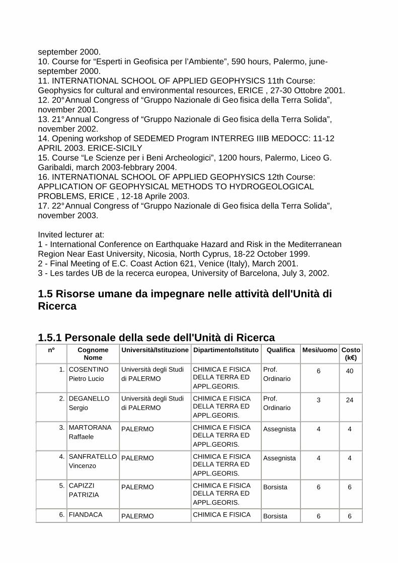
september 2000. 10. Course for “Esperti in Geofisica per l’Ambiente”, 590 hours, Palermo, june- september 2000. 11. INTERNATIONAL SCHOOL OF APPLIED GEOPHYSICS 11th Course: Geophysics for cultural and environmental resources, ERICE , 27-30 Ottobre 2001. 12. 20° Annual Congress of “Gruppo Nazionale di Geo fisica della Terra Solida”, november 2001. 13. 21° Annual Congress of “Gruppo Nazionale di Geo fisica della Terra Solida”, november 2002. 14. Opening workshop of SEDEMED Program INTERREG IIIB MEDOCC: 11-12 APRIL 2003. ERICE-SICILY 15. Course “Le Scienze per i Beni Archeologici”, 1200 hours, Palermo, Liceo G. Garibaldi, march 2003-febbrary 2004. 16. INTERNATIONAL SCHOOL OF APPLIED GEOPHYSICS 12th Course: APPLICATION OF GEOPHYSICAL METHODS TO HYDROGEOLOGICAL PROBLEMS, ERICE , 12-18 Aprile 2003. 17. 22° Annual Congress of “Gruppo Nazionale di Geo fisica della Terra Solida”, november 2003. Invited lecturer at: 1 - International Conference on Earthquake Hazard and Risk in the Mediterranean Region Near East University, Nicosia, North Cyprus, 18-22 October 1999. 2 - Final Meeting of E.C. Coast Action 621, Venice (Italy), March 2001. 3 - Les tardes UB de la recerca europea, University of Barcelona, July 3, 2002. 1.5 Risorse umane da impegnare nelle attività dell' Unità di Ricerca 1.5.1 Personale della sede dell'Unità di Ricerca
nº Cognome Nome
Università/Istituzione Dipartimento/Istituto Qualifica Mesi/uomo Costo (k€)
1. COSENTINO Pietro Lucio
Università degli Studi di PALERMO
CHIMICA E FISICA DELLA TERRA ED APPL.GEORIS.
Prof. Ordinario
6 40
2. DEGANELLO Sergio
Università degli Studi di PALERMO
CHIMICA E FISICA DELLA TERRA ED APPL.GEORIS.
Prof. Ordinario
3 24
3. MARTORANA Raffaele
PALERMO CHIMICA E FISICA DELLA TERRA ED APPL.GEORIS.
Assegnista 4 4
4. SANFRATELLO Vincenzo
PALERMO CHIMICA E FISICA DELLA TERRA ED APPL.GEORIS.
Assegnista 4 4
5. CAPIZZI PATRIZIA
PALERMO CHIMICA E FISICA DELLA TERRA ED APPL.GEORIS.
Borsista 6 6
6. FIANDACA PALERMO CHIMICA E FISICA Borsista 6 6

GIANLUCA DELLA TERRA ED APPL.GEORIS.
7. MESSINA PAOLO
PALERMO CHIMICA E FISICA DELLA TERRA ED APPL.GEORIS.
Borsista 6 6
8. PELLERITO SANTINO
PALERMO CHIMICA E FISICA DELLA TERRA ED APPL.GEORIS.
Borsista 6 6
9. ROMANO LOREDANA
PALERMO CHIMICA E FISICA DELLA TERRA ED APPL.GEORIS.
Borsista 6 6
TOTALE 47 102 1.5.2.a Personale a contratto da destinare a questa specifica proposta progettuale
nº Qualifica Tipologia Mesi/uomo Costo (k €) TOTALE 0 0
1.5.2.b Contratti triennali da destinare a questa s pecifica proposta progettuale
nº Qualifica Tipologia Mesi/uomo Costo (k€)
1. Dottore di ricerca
Contr. triennale per giov. ricerc. 33 39
2. Dottore di ricerca
Contr. triennale per giov. ricerc. 33 39
TOTALE 66 78 1.5.3 Mesi uomo complessivi dedicati alle attività proposte
Numero Mesi/uomo Costo (k€)
1.5.1 Personale della sede dell'Unità di Ricerca 9 47 102
1.5.2.a Personale a contratto da destinare a questa specifica proposta progettuale
0
1.5.2.b Contratti triennali da destinare a questa specifica proposta progettuale
2 66 78
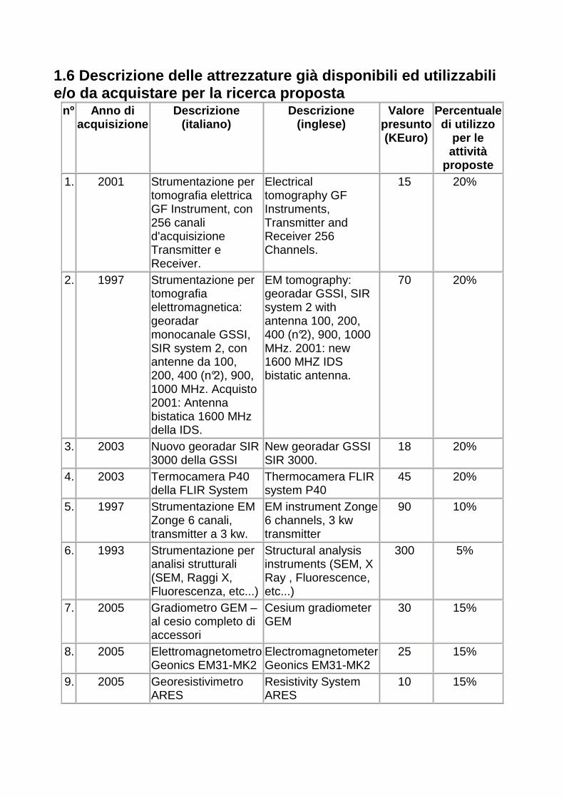
1.6 Descrizione delle attrezzature già disponibili ed utilizzabili e/o da acquistare per la ricerca proposta
nº Anno di acquisizione
Descrizione (italiano)
Descrizione (inglese)
Valore presunto (KEuro)
Percentuale di utilizzo
per le attività
proposte 1. 2001 Strumentazione per
tomografia elettrica GF Instrument, con 256 canali d'acquisizione Transmitter e Receiver.
Electrical tomography GF Instruments, Transmitter and Receiver 256 Channels.
15 20%
2. 1997 Strumentazione per tomografia elettromagnetica: georadar monocanale GSSI, SIR system 2, con antenne da 100, 200, 400 (n°2), 900, 1000 MHz. Acquisto 2001: Antenna bistatica 1600 MHz della IDS.
EM tomography: georadar GSSI, SIR system 2 with antenna 100, 200, 400 (n°2), 900, 1000 MHz. 2001: new 1600 MHZ IDS bistatic antenna.
70 20%
3. 2003 Nuovo georadar SIR 3000 della GSSI
New georadar GSSI SIR 3000.
18 20%
4. 2003 Termocamera P40 della FLIR System
Thermocamera FLIR system P40
45 20%
5. 1997 Strumentazione EM Zonge 6 canali, transmitter a 3 kw.
EM instrument Zonge 6 channels, 3 kw transmitter
90 10%
6. 1993 Strumentazione per analisi strutturali (SEM, Raggi X, Fluorescenza, etc...)
Structural analysis instruments (SEM, X Ray , Fluorescence, etc...)
300 5%
7. 2005 Gradiometro GEM – al cesio completo di accessori
Cesium gradiometer GEM
30 15%
8. 2005 Elettromagnetometro Geonics EM31-MK2
Electromagnetometer Geonics EM31-MK2
25 15%
9. 2005 Georesistivimetro ARES
Resistivity System ARES
10 15%
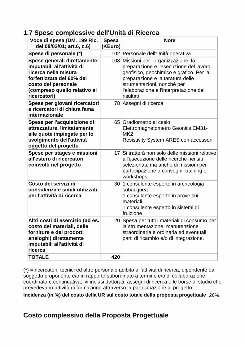
1.7 Spese complessive dell'Unità di Ricerca Voce di spesa (DM. 199 Ric.
del 08/03/01; art.6, c.6) Spesa
(KEuro) Note
Spese di personale (*) 102 Personale dell'Unità operativa Spese generali direttamente imputabili all'attività di ricerca nella misura forfettizzata del 60% del costo del personale (compreso quello relativo ai ricercatori)
108 Missioni per l'organizzazione, la preparazione e l'esecuzione del lavoro geofisico, geochimico e grafico. Per la preparazione e la taratura delle strumentazioni, nonchè per l'elaborazione e l'interpretazione dei risultati
Spese per giovani ricercatori e ricercatori di chiara fama internazionale
78 Assegni di ricerca
Spese per l'acquisizione di attrezzature, limitatamente alle quote impiegate per lo svolgimento dell'attività oggetto del progetto
65 Gradiometro al cesio Elettromagnetometro Geonics EM31-MK2 Resistivity System ARES con accessori
Spese per stages e missioni all'estero di ricercatori coinvolti nel progetto
17 Si tratterà non solo delle missioni relative all'esecuzione delle ricerche nei siti selezionati, ma anche di missioni per partecipazione a convegni, training e workshops.
Costo dei servizi di consulenza e simili utilizzati per l'attività di ricerca
30 1 consulente esperto in archeologia subacquea 1 consulente esperto in prove sui materiali 1 consulente esperto in sistemi di fruizione
Altri costi di esercizio (ad es. costo dei materiali, delle forniture e dei prodotti analoghi) direttamente imputabili all'attività di ricerca
20 Spesa per tutti i materiali di consumo per la strumentazione, manutenzione straordinaria e ordinaria ed eventuali parti di ricambio e/o di integrazione.
TOTALE 420 (*) = ricercatori, tecnici ed altro personale adibito all'attività di ricerca, dipendente dal soggetto proponente e/o in rapporto subordinato a termine e/o di collaborazione coordinata e continuativa, ivi inclusi dottorati, assegni di ricerca e le borse di studio che prevedevano attività di formazione attraverso la partecipazione al progetto. Incidenza (in %) del costo della UR sul costo total e della proposta progettuale 26%
Costo complessivo della Proposta Progettuale

A carico del MIUR
A carico del Proponente
TOTALE
Costo delle attività di ricerca 240 102 342
Costo dei contratti triennali (giovani ricercatori)
78 78
Costo dei contratti triennali (ricercatori di chiara fama)
0
Costo complessivo della Proposta Progettuale
318 102 420
1.8 Certifico la dichiarata disponibilità al cofina nziamento previsto: SI
Unità di Ricerca n. 3
1.1 Descrizione della struttura e dei compiti dell' Unità di Ricerca The research group is compounded by three professor and senior researches of the Technical University of Turin, that has been involved in application of geophysical methods for archaeological prospecting since more than 10 years ago. The team is integrated by young researcher that will be involved in acquisition, data processing of magnetic and electromagnetic measurements, in development of software for rendering of archaeological features. The research will be supplied by a external society involved in archaeological prospecting for a balance between the geophysical interpretation and the meanings of the archaeological features. Dr. S. Piro, ITABC – CNR – Rome will be involved in the project as a consultant for data processing and interpretation georadar and magnetic data processing. The activity of the team will be organized according the following main steps: 1) Data acquisition of Magnetic and Electromagnetic data The team is mainly involved in acquisition of magnetic/gradiometric data for high resolution mapping of archaeo-magnetic anomalies. Electromagnetic data will be acquired using high resolution techniques and a broadband device (1000 Hz – 48 kHz – GEM3- Geophex) of new design. The electromagnetic data acquisition in step frequency mode will permit to map the elecromagnetic response of the archaeological sites at different frequencies; this means under certain theoretical and practical condition the possibility to separate the response at different depth of investigation; 2) Data processing A preliminary evaluation of the archaeological structures will be realized using an
integrated approach based on the application of Eulero/Wavelet and Analytic signal analysis of the magnetic and electromagnetic data. The procedure permits a semi-automatic and fast interpretation of the archaeological elements in terms of depth and magnetic parameters of the features. 3) Interpretation of mag and electromag data The task involves the procedures of modelling and inversion of the magnetic data in terms of vertical section of the subsoil (2D) and 3D interpretation of the geophysical results. The 3D elaboration of magnetic data will be carried out using the code Mag3D (Li and Oldenburg, 1997) that permit a robust and accurate modelling and inversion of the magnetic anomalies referring to the main archaelogicl structures. The code takes in to account the surface morphology and furnish the output of the shape of the archaeological features and the magnetic suscettivity contrast between the host material and the structures. This procedure will be guided by the results of the preliminary data processing describeb at the task 2. The data processing of electromagnetic data will be realized using standard monodimensional inversion and 2D modeling techniques. The main goal of the processing of electromagnetic data is to point out the archaelogical features at different depth and calibrate the results of data processing of electrical resistivity tomography, performed by other research units. The task involves the calibration and validation of geophysical approach by integration of magnetic and electromagnetic interpretation and comparison of the geophysical interpretation and the evidence of some archaeological elements (voids, tombs, walls ecc.). 4) Rendering 3D of mag and elmag data This task involves the optimization of procedure of 3D interpolation of geophysical data using geostatistical approach that permit to perform joint analysis (cokriging) of magnetic (suscettivity) and electromagnetic parameters with cross-validation of all the variables. The development of software codes for 3D rendering of magnetic and electromagnetic data will be realised in Matlab environment customized on the specific requirements of archaeological interpretation 5) Result disclosure The task involves all the action for the disclosure of the results of the research both in terms of methodology improvement, both of the 3D visualization of the archaeological sites; this objective will be reached by means of the realization of movies of the 3D rendering in order to explore the archaeological sites from different point of view. The results will be organized both on CD and in Web sites. 1.2 Responsabile Scientifico dell'Unità di Ricerca
GODIO Alberto GDOLRT63S02L746T
(cognome) (nome) (CF)
Ricercatore Universitario
02/11/1963
(qualifica) (data di nascita)
Politecnico di TORINO
Dip. GEORISORSE E TERRITORIO
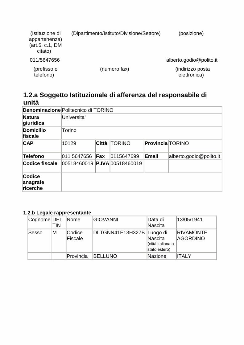
(Istituzione di appartenenza) (art.5, c.1, DM
citato)
(Dipartimento/Istituto/Divisione/Settore)
(posizione)
011/5647656 [email protected]
(prefisso e telefono)
(numero fax) (indirizzo posta elettronica)
1.2.a Soggetto Istituzionale di afferenza del respo nsabile di unità Denominazione Politecnico di TORINO Natura giuridica
Universita'
Domicilio fiscale
Torino
CAP 10129 Città
TORINO Provincia
TORINO
Telefono 011 5647656 Fax 0115647699 Email [email protected] Codice fiscale 00518460019 P.IVA
00518460019
Codice anagrafe ricerche
1.2.b Legale rappresentante
Cognome
DEL TIN
Nome GIOVANNI Data di Nascita
13/05/1941
Sesso M Codice Fiscale
DLTGNN41E13H327B Luogo di Nascita (città italiana o stato estero)
RIVAMONTE AGORDINO
Provincia BELLUNO Nazione ITALY
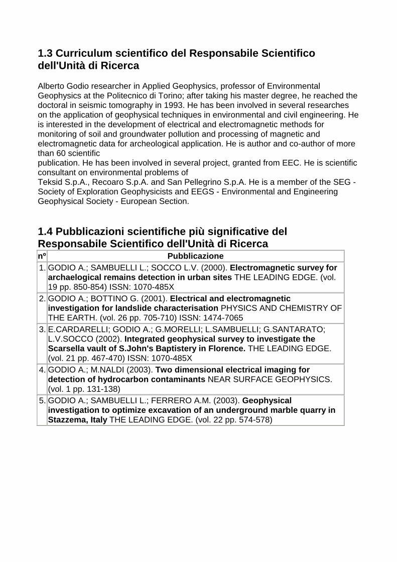
1.3 Curriculum scientifico del Responsabile Scienti fico dell'Unità di Ricerca Alberto Godio researcher in Applied Geophysics, professor of Environmental Geophysics at the Politecnico di Torino; after taking his master degree, he reached the doctoral in seismic tomography in 1993. He has been involved in several researches on the application of geophysical techniques in environmental and civil engineering. He is interested in the development of electrical and electromagnetic methods for monitoring of soil and groundwater pollution and processing of magnetic and electromagnetic data for archeological application. He is author and co-author of more than 60 scientific publication. He has been involved in several project, granted from EEC. He is scientific consultant on environmental problems of Teksid S.p.A., Recoaro S.p.A. and San Pellegrino S.p.A. He is a member of the SEG - Society of Exploration Geophysicists and EEGS - Environmental and Engineering Geophysical Society - European Section. 1.4 Pubblicazioni scientifiche più significative de l Responsabile Scientifico dell'Unità di Ricerca nº Pubblicazione 1. GODIO A.; SAMBUELLI L.; SOCCO L.V. (2000). Electromagnetic survey for
archaelogical remains detection in urban sites THE LEADING EDGE. (vol. 19 pp. 850-854) ISSN: 1070-485X
2. GODIO A.; BOTTINO G. (2001). Electrical and electromagnetic investigation for landslide characterisation PHYSICS AND CHEMISTRY OF THE EARTH. (vol. 26 pp. 705-710) ISSN: 1474-7065
3. E.CARDARELLI; GODIO A.; G.MORELLI; L.SAMBUELLI; G.SANTARATO; L.V.SOCCO (2002). Integrated geophysical survey to investigate the Scarsella vault of S.John's Baptistery in Florence. THE LEADING EDGE. (vol. 21 pp. 467-470) ISSN: 1070-485X
4. GODIO A.; M.NALDI (2003). Two dimensional electrical imaging for detection of hydrocarbon contaminants NEAR SURFACE GEOPHYSICS. (vol. 1 pp. 131-138)
5. GODIO A.; SAMBUELLI L.; FERRERO A.M. (2003). Geophysical investigation to optimize excavation of an undergro und marble quarry in Stazzema, Italy THE LEADING EDGE. (vol. 22 pp. 574-578)
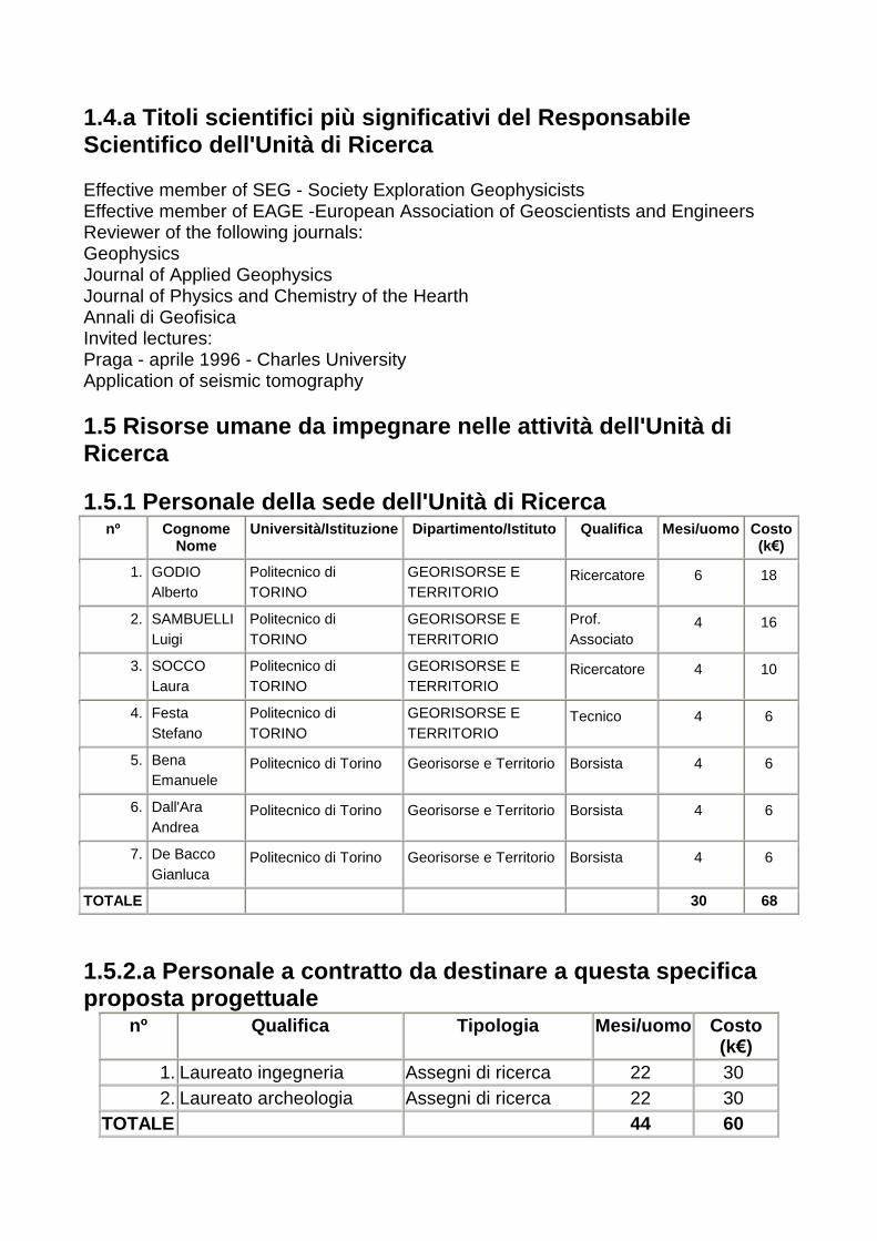
1.4.a Titoli scientifici più significativi del Resp onsabile Scientifico dell'Unità di Ricerca Effective member of SEG - Society Exploration Geophysicists Effective member of EAGE -European Association of Geoscientists and Engineers Reviewer of the following journals: Geophysics Journal of Applied Geophysics Journal of Physics and Chemistry of the Hearth Annali di Geofisica Invited lectures: Praga - aprile 1996 - Charles University Application of seismic tomography 1.5 Risorse umane da impegnare nelle attività dell' Unità di Ricerca 1.5.1 Personale della sede dell'Unità di Ricerca
nº Cognome Nome
Università/Istituzione Dipartimento/Istituto Qualifica Mesi/uomo Costo (k€)
1. GODIO Alberto
Politecnico di TORINO
GEORISORSE E TERRITORIO
Ricercatore 6 18
2. SAMBUELLI Luigi
Politecnico di TORINO
GEORISORSE E TERRITORIO
Prof. Associato
4 16
3. SOCCO Laura
Politecnico di TORINO
GEORISORSE E TERRITORIO
Ricercatore 4 10
4. Festa Stefano
Politecnico di TORINO
GEORISORSE E TERRITORIO
Tecnico 4 6
5. Bena Emanuele
Politecnico di Torino Georisorse e Territorio Borsista 4 6
6. Dall'Ara Andrea
Politecnico di Torino Georisorse e Territorio Borsista 4 6
7. De Bacco Gianluca
Politecnico di Torino Georisorse e Territorio Borsista 4 6
TOTALE 30 68 1.5.2.a Personale a contratto da destinare a questa specifica proposta progettuale
nº Qualifica Tipologia Mesi/uomo Costo (k€)
1. Laureato ingegneria Assegni di ricerca 22 30 2. Laureato archeologia Assegni di ricerca 22 30
TOTALE 44 60

1.5.2.b Contratti triennali da destinare a questa s pecifica proposta progettuale
nº Qualifica Tipologia Mesi/uomo Costo (k€)
1. Ricercatore competenze archeologiche
Contr. triennale per giov. ricerc.
33 45
TOTALE 33 45 1.5.3 Mesi uomo complessivi dedicati alle attività proposte
Numero Mesi/uomo Costo (k€)
1.5.1 Personale della sede dell'Unità di Ricerca 7 30 68
1.5.2.a Personale a contratto da destinare a questa specifica proposta progettuale
2 44 60
1.5.2.b Contratti triennali da destinare a questa specifica proposta progettuale
1 33 45
1.6 Descrizione delle attrezzature già disponibili ed utilizzabili e/o da acquistare per la ricerca proposta
nº Anno di acquisizione
Descrizione (italiano) Descrizione (inglese) Valore presunto (KEuro)
Percentuale di utilizzo
per le attività
proposte 1. 2002 Georesistivimetro 72 canali
per acquisizioni di tomografia elettrica e di polarizzazione indotta
Device for electrical resistivity tomography with 72 electrodes
30 10%
2. 2000 Magnetometro/gradiometro GEM GS19
Magnetometer/Gradiometer GEM GS19
15 50%
3. 1998 Elettromagnetometro a frequenza singola CM031
Conductivity meter 9,8 kHz - CM031 Geophizica
10 20%
4. 2005 Elettromagnetometro multifrequenza GEM 3 - Geophex
Conductivity meter (broadband - 1 - 48 kHz) - GEM 3 - Geophex
10 60%
5. 2001 Programma di elaborazione dati 3D EVS
EVS code for Rendering 3D
5 20%
6. 2005 Matlab 6.0 con toolbox per Matlab 6.0 and toolboxes 4 20%

image processing for image processing 7. 2005 Computer da campo
portatili (2) Laptop (2) 6 100%
8. 2005 Personal computer (1) Personal computer (1) 2 40% 9. 2005 Dispositivo GPS per
misure cinematiche GPS devive for kinematic measurements
15 80%
1.7 Spese complessive dell'Unità di Ricerca
Voce di spesa (DM. 199 Ric. del 08/03/01; art.6, c.6)
Spesa (KEuro)
Note
Spese di personale (*) 128 Sono state calcolate sulla base dei mesi uomo previsti per il personale impegnato nei tre anni di attività di ricerca
Spese generali direttamente imputabili all'attività di ricerca nella misura forfettizzata del 60% del costo del personale (compreso quello relativo ai ricercatori)
103 Attività di allestimento delle indagini magnetiche e elettromagnetiche nei siti selezionati, costi strutturali e amministrativi; spese per missioni e trasferte nei diversi siti archeologici, allestimenti strumentazione per acquisizione
Spese per giovani ricercatori e ricercatori di chiara fama internazionale
45 Giovane ricercatore con competenze archeologiche per la gestione delle attività di acquisizione dati nei diversi siti
Spese per l'acquisizione di attrezzature, limitatamente alle quote impiegate per lo svolgimento dell'attività oggetto del progetto
37 Acquisto di strumentazione multifrequenza per misure elettromagnetiche dei siti archeologici; acquisto ed implementazione di software ed hardware; nuovo dispositivo GPS da collegare a dispositivi di acquisizione
Spese per stages e missioni all'estero di ricercatori coinvolti nel progetto
10 Partecipazione a seminari, congressi e attività di formazione nel settore specifico
Costo dei servizi di consulenza e simili utilizzati per l'attività di ricerca
12 Coinvolgimento del CNR per il supporto nell'elaborazione d interpretazione dei dati geofisici Consulenza di società esperta in archeologia per il supporto all'integrazione tra dati geofisici e interpretazione della natura dell strutture sepolte.
Altri costi di esercizio (ad es. costo dei m ateriali, delle
10 Costi di trasporto e assicurazione strumentazione; pratiche doganali
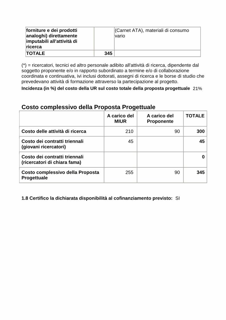
forniture e dei prodotti analoghi) direttamente imputabili all'attività di ricerca
(Carnet ATA), materiali di consumo vario
TOTALE 345 (*) = ricercatori, tecnici ed altro personale adibito all'attività di ricerca, dipendente dal soggetto proponente e/o in rapporto subordinato a termine e/o di collaborazione coordinata e continuativa, ivi inclusi dottorati, assegni di ricerca e le borse di studio che prevedevano attività di formazione attraverso la partecipazione al progetto. Incidenza (in %) del costo della UR sul costo total e della proposta progettuale 21%
Costo complessivo della Proposta Progettuale
A carico del MIUR
A carico del Proponente
TOTALE
Costo delle attività di ricerca 210 90 300
Costo dei contratti triennali (giovani ricercatori)
45 45
Costo dei contratti triennali (ricercatori di chiara fama)
0
Costo complessivo della Proposta Progettuale
255 90 345
1.8 Certifico la dichiarata disponibilità al cofina nziamento previsto: SI

Unità di Ricerca n. 4
1.1 Descrizione della struttura e dei compiti dell' Unità di Ricerca The Consortium (National Interuniversity Consortium for Marine Sciences), established in February 1994, is a non-profit-making organisation controlled by the Ministry of Instruction, Universities and Research and it consists of 28 Italian Universities. The CoNISMa purposes are to promote and co-ordinate researches and other scientific and applicable activities in the field of Marine sciences, favouring the co-operation not only among the associated Universities, but also with other Universities, with public and private research Bodies, local and territorial Authorities, production structures. The Local Research Unit of Milano-Bicocca University is composed by two units of personnel under permanent contract (one full professor and one researcher) that will be supported by one personnel unit specifically devoted to the project for three years, and funded on the project itself. The main tasks that the local sub-unit will concern the geophysical data acquisition,processing and interpretation and in particular will be: (a)design of the prototypal hovercraft vessel and development in coordination with Conisma personnel; the vessel development is key to the shallow water investigations (b)planning of the marine operations at the test sites, with particular emphasis on multibeam, side scan sonar and CHIRP acquisition. (c)data acquisition on site, as planned at point (b) (d)data processing and interpretation, including handing over of the processed data in suitable format to other research units, for integration with other data and visualization (e)support to land operations of other research units, with particular regard to surface electrical tomography, with use of the available Iris Syscal Pro recently acquired, to be supplemented with adequate multiplexer. The Local Research Unit of Palermo University is composed by one unit of personnel under permanent contract (one full professor) that will be supported by one personnel unit specifically devoted to the project for three years, and funded on the project itself. The main tasks that the local sub-unit will be: (a)planning of the remote sensing data acquisition at the test sites, with particular emphasis on multispectral sensor, (b)data processing and interpretation, including handing over of the processed data in suitable format to other research units, for integration with other data and visualization. 1.2 Responsabile Scientifico dell'Unità di Ricerca
FARANDA Francesco Maria FRNFNC33D13L482F
(cognome) (nome) (CF)

Coordinatore unità CoNISMa
13/04/1933
(qualifica) (data di nascita)
CONSORZIO NAZIONALE
INTERUNIVERSITARIO PER LE SCIENZE DEL
MARE (CONISMA)
Unità Locale di Ricerca Univ. Milano-Bicocca
Vice-Presidente
(Istituzione di appartenenza)
(art.5, c.1, DM citato)
(Dipartimento/Istituto/Divisione/Settore)
(posizione)
0685355476 [email protected]
(prefisso e telefono) (numero fax) (indirizzo posta elettronica)
1.2.a Soggetto Istituzionale di afferenza del respo nsabile di unità
Denominazione CONSORZIO NAZIONALE INTERUNIVERSITARIO PER LE SCIENZE DEL MARE (CONISMA)
Natura giuridica
Altri soggetti, con personalita' giuridica, pubbl. o priv.
Domicilio fiscale
via Isonzo, 32
CAP 00198 Città
Roma Provincia
ROMA
Telefono 06 85355476 Fax 06 8543810 Email [email protected] Codice fiscale 91020470109 P.IVA
01069050993
Codice anagrafe ricerche
515810DU
1.2.b Legale rappresentante
Cognome
CORSELLI Nome CESARE Data di Nascita
17/12/1948
Sesso M Codice Fiscale
CRSCSR48T17D869H Luogo di Nascita (città italiana o stato estero)
GALLARATE
Provincia
VARESE Nazione ITALY
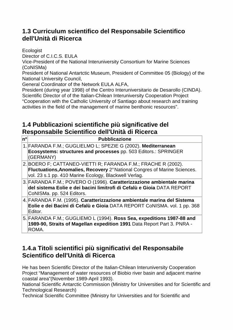
1.3 Curriculum scientifico del Responsabile Scienti fico dell'Unità di Ricerca Ecologist Director of C.I.C.S. EULA Vice-President of the National Interuniversity Consortium for Marine Sciences (CoNISMa) President of National Antartctic Museum, President of Committee 05 (Biology) of the National University Council, General Coordinator of the Network EULA ALFA, President (during year 1998) of the Centro Interuniversitario de Desarollo (CINDA). Scientific Director of of the Italian-Chilean Interuniversity Cooperation Project “Cooperation with the Catholic University of Santiago about research and training activities in the field of the management of marine benthonic resources”. 1.4 Pubblicazioni scientifiche più significative de l Responsabile Scientifico dell'Unità di Ricerca nº Pubblicazione 1. FARANDA F.M.; GUGLIELMO L; SPEZIE G (2002). Mediterranean
Ecosystems: structures and processes pp. 503 Editors.: SPRINGER (GERMANY)
2. BOERO F; CATTANEO-VIETTI R; FARANDA F.M.; FRACHE R (2002). Fluctuations,Anomalies, Recovery 2° National Congres of Marine Sciences. vol. 23 s.1 pp. 410 Marine Ecology, Blackwell Verlag.
3. FARANDA F.M.; POVERO O (1996). Caratterizzazione ambientale marina del sistema Eolie e dei bacini limitrofi di Cefalù e Gioia DATA REPORT CoNISMa. pp. 524 Editors.
4. FARANDA F.M. (1995). Caratterizzazione ambientale marina del Sistema Eolie e dei Bacini di Cefalù e Gioia DATA REPORT CoNISMA. vol. 1 pp. 368 Editor.
5. FARANDA F.M.; GUGLIEMO L (1994). Ross Sea, expeditions 1987-88 and 1989-90, Straits of Magellan expedition 1991 Data Report Part 3. PNRA - ROMA.
1.4.a Titoli scientifici più significativi del Resp onsabile Scientifico dell'Unità di Ricerca He has been Scientific Director of the Italian-Chilean Interuniversity Cooperation Project “Management of water resources of Biobio river basin and adjacent marine coastal area”(November 1989-April 1993). National Scientific Antarctic Commission (Ministry for Universities and for Scientific and Technological Research) Technical Scientific Committee (Ministry for Universities and for Scientific and

Technological Research). National Sea Council (Ministry for Environment, Sea Inspectorate) 1.5 Risorse umane da impegnare nelle attività dell' Unità di Ricerca 1.5.1 Personale della sede dell'Unità di Ricerca
nº Cognome Nome
Università/Istituzione Dipartimento/Istituto Qualifica Mesi/uomo Costo (k€)
1. CASSIANI Giorgio
CONSORZIO NAZIONALE INTERUNIVERSITARIO PER LE SCIENZE DEL MARE (CONISMA)
Unità Locale di Ricerca Università di Milano-Bicocca
Ricercatore universitario
10 15
2. CORSELLI Cesare
CONSORZIO NAZIONALE INTERUNIVERSITARIO PER LE SCIENZE DEL MARE (CONISMA)
UNità Locale di Ricerca Università di MIlano-Bicocca
Professore straordinario
9 27
3. FARANDA Francesco Maria
CONSORZIO NAZIONALE INTERUNIVERSITARIO PER LE SCIENZE DEL MARE (CONISMA)
Unità Locale di Ricerca Univ. Milano-Bicocca
ALTRO 1 2
4. LA LOGGIA Goffredo
CONSORZIO NAZIONALE INTERUNIVERSITARIO PER LE SCIENZE DEL MARE (CONISMA)
Unità Locale di Ricerca Università di Palermo
Professore ordinario
9 27
TOTALE 29 71 1.5.2.a Personale a contratto da destinare a questa specifica proposta progettuale
nº Qualifica Tipologia Mesi/uomo Costo (k€)
1. Laureato Assegni di ricerca 33 45 2. Laureato Assegni di ricerca 33 45
TOTALE 66 90 1.5.2.b Contratti triennali da destinare a questa s pecifica proposta progettuale
nº Qualifica Tipologia Mesi/uomo Costo (k €) TOTALE 0 0

1.5.3 Mesi uomo complessivi dedicati alle attività proposte
Numero Mesi/uomo Costo (k€)
1.5.1 Personale della sede dell'Unità di Ricerca 4 29 71
1.5.2.a Personale a contratto da destinare a questa specifica proposta progettuale
2 66 90
1.5.2.b Contratti triennali da destinare a questa specifica proposta progettuale
0
1.6 Descrizione delle attrezzature già disponibili ed utilizzabili e/o da acquistare per la ricerca proposta
nº Anno di acquisizione
Descrizione (italiano)
Descrizione (inglese)
Valore presunto (KEuro)
Percentuale di utilizzo
per le attività proposte
1. 2004 Ecoscandaglio multifascio ad alta risoluzione
Multibeam Echosounder high resolution
0 5%
2. 2002 Sonar a scansione laterale KLEIN300
Side Scan Sonar Klein 3000
0 5%
3. 2002 Profilatore di sottofondo Geo-Chirp
Chirp sub-bottom profiler Geo-Chirp
0 5%
4. 2002 DGPS DGPS 0 5% 5. 2002 Compensatore di
rollio, beccheggio e moto ondoso
Sensor for pich, roll and wave
0 5%
6. 2004 Prototipo hovercraft per rilievi in acque basse
Hovercraft prototype for survey S.W.
25 100%
7. 2004 Multiplexer per Isis Silver pro
Multiplexer per Isis Silver pro
15 100%
8. 2004 Upgrading strumentale per telerilevamento
Upgrading for remote sensing
35 100%
9. 2004 Iris Syscal Pro Iris Syscal Pro 0 5% 1.7 Spese complessive dell'Unità di Ricerca
Voce di spesa (DM. 199 Ric. del 08/03/01; art.6, c.6)
Spesa (KEuro)
Note
Spese di personale (*) 161 Personale docente
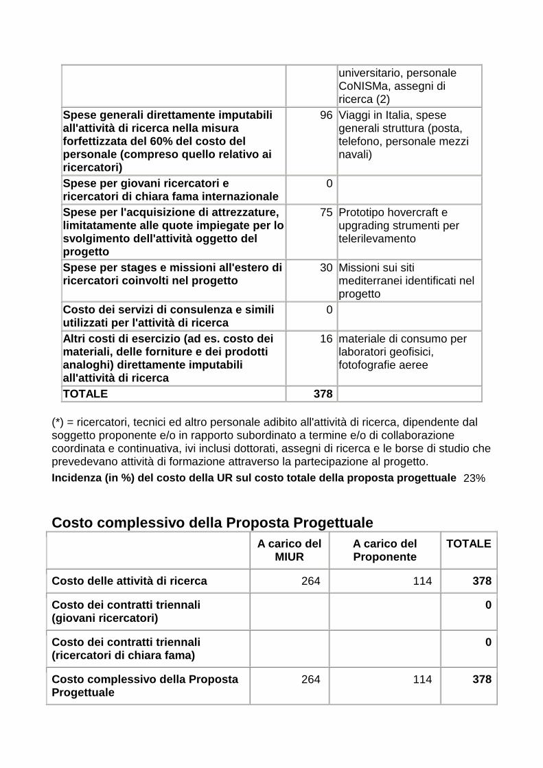
universitario, personale CoNISMa, assegni di ricerca (2)
Spese generali direttamente imputabili all'attività di ricerca nella misura forfettizzata del 60% del costo del personale (compreso quello relativo ai ricercatori)
96 Viaggi in Italia, spese generali struttura (posta, telefono, personale mezzi navali)
Spese per giovani ricercatori e ricercatori di chiara fama internazionale
0
Spese per l'acquisizione di attrezzature, limitatamente alle quote impiegate per lo svolgimento dell'attività oggetto del progetto
75 Prototipo hovercraft e upgrading strumenti per telerilevamento
Spese per stages e missioni all'estero di ricercatori coinvolti nel progetto
30 Missioni sui siti mediterranei identificati nel progetto
Costo dei servizi di consulenza e simili utilizzati per l'attività di ricerca
0
Altri costi di esercizio (ad es. costo dei materiali, delle forniture e dei prodotti analoghi) direttamente imputabili all'attività di ricerca
16 materiale di consumo per laboratori geofisici, fotofografie aeree
TOTALE 378 (*) = ricercatori, tecnici ed altro personale adibito all'attività di ricerca, dipendente dal soggetto proponente e/o in rapporto subordinato a termine e/o di collaborazione coordinata e continuativa, ivi inclusi dottorati, assegni di ricerca e le borse di studio che prevedevano attività di formazione attraverso la partecipazione al progetto. Incidenza (in %) del costo della UR sul costo total e della proposta progettuale 23%
Costo complessivo della Proposta Progettuale
A carico del MIUR
A carico del Proponente
TOTALE
Costo delle attività di ricerca 264 114 378
Costo dei contratti triennali (giovani ricercatori)
0
Costo dei contratti triennali (ricercatori di chiara fama)
0
Costo complessivo della Proposta Progettuale
264 114 378
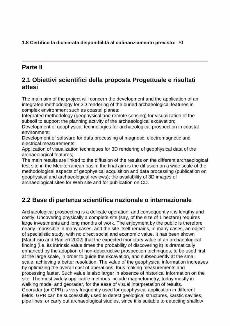
1.8 Certifico la dichiarata disponibilità al cofina nziamento previsto: SI
Parte II 2.1 Obiettivi scientifici della proposta Progettual e e risultati attesi The main aim of the project will concern the development and the application of an integrated methodology for 3D rendering of the buried archaeological features in complex environment such as coastal planes: Integrated methodology (geophysical and remote sensing) for visualization of the subsoil to support the planning activity of the archaeological excavation; Development of geophysical technologies for archaeological prospection in coastal environment; Development of software for data processing of magnetic, electromagnetic and electrical measurements; Application of visualization techniques for 3D rendering of geophysical data of the archaeological features; The main results are linked to the diffusion of the results on the different archaeological test site in the Mediterranean basin; the final aim is the diffusion on a wide scale of the methodological aspects of geophysical acquisition and data processing (publication on geophysical and archaeological reviews); the availability of 3D images of archaeological sites for Web site and for publication on CD. 2.2 Base di partenza scientifica nazionale o intern azionale Archaeological prospecting is a delicate operation, and consequently it is lengthy and costly. Uncovering physically a complete site (say, of the size of 1 hectare) requires large investments and long months of work. The enjoyment by the public is therefore nearly impossible in many cases, and the site itself remains, in many cases, an object of specialistic study, with no direct social and economic value. It has been shown [Marchisio and Ranieri 2002] that the expected monetary value of an archaeological finding (i.e. its intrinsic value times the probability of discovering it) is dramatically enhanced by the adoption of non-desctructive prospection techniques, to be used first at the large scale, in order to guide the excavation, and subsequently at the small scale, achieving a better resolution. The value of the geophysical information increases by optimizing the overall cost of operations, thus making measurements and processing faster. Such value is also larger in absence of historical information on the site. The most widely applicable methods include magnetometry, today mostly in walking mode, and georadar, for the ease of visual interpretation of results. Georadar (or GPR) is very frequently used for geophysical application in different fields. GPR can be successfully used to detect geological structures, karstic cavities, pipe lines, or carry out archaeological studies, since it is suitable to detecting shallow

underground anomalies (Annan et al, 1975). The "time slices” or “depth-slices” technique is used in many GPR applications to produce a graphic representation of profiles (Piro et alii, 2002). This technique represents one of several ways of carrying out reflection tomography. The time slices technique allows to reconstruct through horizontal sections the planimetric behavior of the reflections that are produced by underground electromagnetic discontinuities. Time slices have proved to be highly valuable at detecting underground cavities and buried structures in general; they can render the images of the shape of those bodies and of its geometrical variation with depth. Construction of time slices allows the implementation of 3D modelling, thus facilitating the identification of the location of the principal anomalies detected. Magnetic and electromagnetic methods are widely adopted in archaeological prospecting for detecting and delineating shallow subsurface targets. The effectiveness of magnetic survey in archaeology is related to several factors, including alteration of magnetic properties due to fire and magnetic susceptibility contrasts in soils. The remanent magnetization (the permanent magnetic effect) and the magnetic susceptibility (the bulk magnetic property) are dependent on the presence of iron (e.g., iron oxides) in the host environments or in the archaeological features. Magnetic susceptibility contrast between topsoil, subsoil and rocks permits to detect ditches, pits and other silted-up features that were excavated and then silted or back-filled with topsoil. Remanent magnetization can be associated with iron objects as well as with ceramics, hearths, fire pits, fire-altered soils and stone; the effects are sometimes greater than susceptibility effects. In such a context, the data processing and the interpretation of the archeo-magnetic anomalies in terms of shape and physical properties of the causative bodies requires great cares. Furthermore, the high density of measures, that can be obtained by applying advanced magnetic acquisition instruments and procedures [e.g. Becker, 1995], requires the application of semi-automatic or automatic data processing for improving the quality of the results in terms of spatial position, orientation, shape and magnetization of the causative bodies. The magnetic and electromagnetic methods for archaeological prospecting are widely used in different test site in Italy (Selinunte, Montelibretti, …) and has been experimented by different research groups [Brizzolati et al, 1993, Piro et al. 1998, Godio et. al. 2001, Brecciaroli et al. 2000]. Magnetic and electromagnetic measurements can be integrated in a joint interpretation. A new algorithm [Benech, C et al. 2002], using a filtering process incorporating both types of data, has been successfully adopted in several case studies in archaeological prospecting. The approach presents two advantages: establishing the presence of remanent magnetizations (viscous or thermoremanent), and achieving more refined depth analysis of the anomaly. In more recent times, electrical resistivity tomography (ERT) has been substantially developed. ERT is a well established technique in 2D acquisition, and provides 2D imaging of sections with resistivity variations in space. 2D inversion techniques are robust and useful, but the acquisition itself can be cumbersome and expensive. A need exists to develop techniques that allow for a continuous spatial acquisitions of ERT data. The value of geophysical information increases substantially in the absence of other sources of information. Such is the case for submarine archaeological sites, where information is lacking and few are the instances of excavation. Geophysical techniques in water are different, with the prevalence of methods based on acoustic waves [Frey,
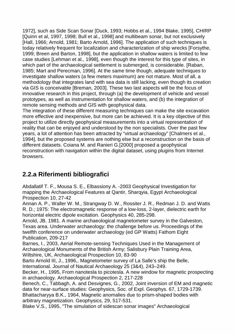
1972], such as Side Scan Sonar [Duck, 1993; Hobbs et al., 1994 Blake, 1995], CHIRP [Quinn et al, 1997, 1998; Bull et al., 1998] and multibeam sonar, but not exclusively [Hall, 1966; Arnold, 1981; Barto Arnold, 1996]. The application of such techniques is today relatively frequent for localization and characterization of ship wrecks [Forsythe, 1999; Breen and Barton, 1998], but the application in shallow waters is limited to few case studies [Lehman et al., 1998], even though the interest for this type of sites, in which part of the archaeological settlement is submerged, is considerable. [Raban, 1985; Mart and Perecman, 1996]. At the same time though, adequate techniques to investigate shallow waters (a few meters maximum) are not mature. Most of all, a methodology that integrates land with sea data is still lacking, even though its creation via GIS is conceivable [Breman, 2003]. These two last aspects will be the focus of innovative research in this project, through (a) the development of vehicle and vessel prototypes, as well as instrumentation for shallow waters, and (b) the integration of remote sensing methods and GIS with geophysical data. The integration of these different measuring techniques can make the site excavation more effective and inexpensive, but more can be achieved. It is a key objective of this project to utilize directly geophysical measurements into a virtual representation of reality that can be enjoyed and understood by the non specialists. Over the past few years, a lot of attention has been attracted by “virtual archaeology” [Chalmers et al., 1994], but the proposed systems are nothing else but a reconstruction on the basis of different datasets. Coiana M. and Ranieri G.[2000] proposed a geophysical reconstruction with navigation within the digital dataset, using plugins from Internet browsers. 2.2.a Riferimenti bibliografici Abdallatif T. F., Mousa S. E., Elbassiony A. -2003 Geophysical Investigation for mapping the Archaeological Features at Qantir, Sharqyia, Egypt Archaeological Prospection 10, 27-42 Annan A. P., Waller W. M., Strangway D. W., Rossiter J. R., Redman J. D. and Watts R. D.; 1975: The electromagnetic response of a low-loss, 2-layer, dielectric earth for horizontal electric dipole excitation. Geophysics 40, 285-298. Arnold, JB. 1981. A marine archaeological magnetometer survey in the Galveston, Texas area. Underwater archaeology: the challenge before us. Proceedings of the twelfth conference on underwater archaeology (ed GP Watts) Fathom Eight Publication, 209-217 Barnes, I., 2003, Aerial Remote-sensing Techniques Used in the Management of Archaeological Monuments of the British Army; Salisbury Plain Training Area, Wiltshire, UK, Archaeological Prospection 10, 83-90 Barto Arnold III, J., 1996,. Magnetometer survey of La Salle’s ship the Belle, International. Journal of Nautical Archaeology 25 (3&4), 243–249. Becker, H., 1995, From nanotesla to picotesla. A new window for magnetic prospecting in archaeology. Archaeological Prospection 2, 217-228 Benech, C., Tabbagh, A. and Desvignes, G., 2002, Joint inversion of EM and magnetic data for near-surface studies: Geophysics, Soc. of Expl. Geophys. 67, 1729-1739. Bhattacharyya B.K., 1964, Magnetic anomalies due to prism-shaped bodies with arbitrary magnetization. Geophysics, 29, 517-531. Blake V.S., 1995, "The simulation of sidescan sonar images" Archaeological
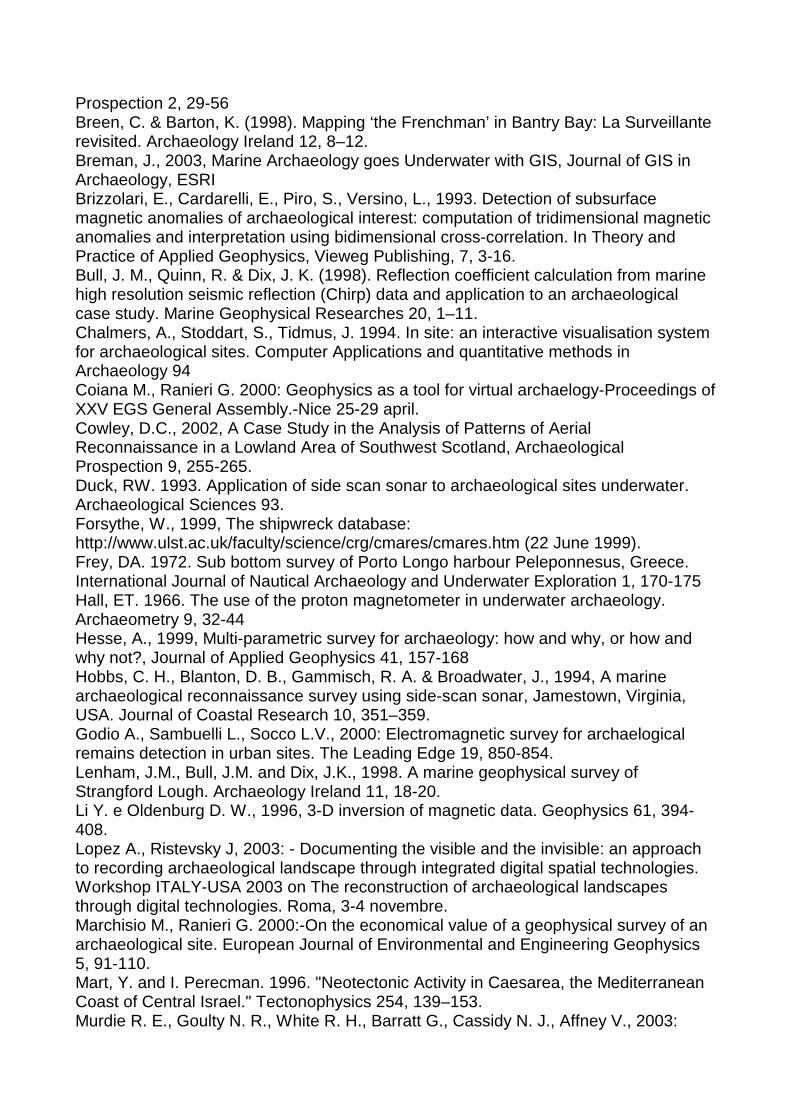
Prospection 2, 29-56 Breen, C. & Barton, K. (1998). Mapping ‘the Frenchman’ in Bantry Bay: La Surveillante revisited. Archaeology Ireland 12, 8–12. Breman, J., 2003, Marine Archaeology goes Underwater with GIS, Journal of GIS in Archaeology, ESRI Brizzolari, E., Cardarelli, E., Piro, S., Versino, L., 1993. Detection of subsurface magnetic anomalies of archaeological interest: computation of tridimensional magnetic anomalies and interpretation using bidimensional cross-correlation. In Theory and Practice of Applied Geophysics, Vieweg Publishing, 7, 3-16. Bull, J. M., Quinn, R. & Dix, J. K. (1998). Reflection coefficient calculation from marine high resolution seismic reflection (Chirp) data and application to an archaeological case study. Marine Geophysical Researches 20, 1–11. Chalmers, A., Stoddart, S., Tidmus, J. 1994. In site: an interactive visualisation system for archaeological sites. Computer Applications and quantitative methods in Archaeology 94 Coiana M., Ranieri G. 2000: Geophysics as a tool for virtual archaelogy-Proceedings of XXV EGS General Assembly.-Nice 25-29 april. Cowley, D.C., 2002, A Case Study in the Analysis of Patterns of Aerial Reconnaissance in a Lowland Area of Southwest Scotland, Archaeological Prospection 9, 255-265. Duck, RW. 1993. Application of side scan sonar to archaeological sites underwater. Archaeological Sciences 93. Forsythe, W., 1999, The shipwreck database: http://www.ulst.ac.uk/faculty/science/crg/cmares/cmares.htm (22 June 1999). Frey, DA. 1972. Sub bottom survey of Porto Longo harbour Peleponnesus, Greece. International Journal of Nautical Archaeology and Underwater Exploration 1, 170-175 Hall, ET. 1966. The use of the proton magnetometer in underwater archaeology. Archaeometry 9, 32-44 Hesse, A., 1999, Multi-parametric survey for archaeology: how and why, or how and why not?, Journal of Applied Geophysics 41, 157-168 Hobbs, C. H., Blanton, D. B., Gammisch, R. A. & Broadwater, J., 1994, A marine archaeological reconnaissance survey using side-scan sonar, Jamestown, Virginia, USA. Journal of Coastal Research 10, 351–359. Godio A., Sambuelli L., Socco L.V., 2000: Electromagnetic survey for archaelogical remains detection in urban sites. The Leading Edge 19, 850-854. Lenham, J.M., Bull, J.M. and Dix, J.K., 1998. A marine geophysical survey of Strangford Lough. Archaeology Ireland 11, 18-20. Li Y. e Oldenburg D. W., 1996, 3-D inversion of magnetic data. Geophysics 61, 394-408. Lopez A., Ristevsky J, 2003: - Documenting the visible and the invisible: an approach to recording archaeological landscape through integrated digital spatial technologies. Workshop ITALY-USA 2003 on The reconstruction of archaeological landscapes through digital technologies. Roma, 3-4 novembre. Marchisio M., Ranieri G. 2000:-On the economical value of a geophysical survey of an archaeological site. European Journal of Environmental and Engineering Geophysics 5, 91-110. Mart, Y. and I. Perecman. 1996. "Neotectonic Activity in Caesarea, the Mediterranean Coast of Central Israel." Tectonophysics 254, 139–153. Murdie R. E., Goulty N. R., White R. H., Barratt G., Cassidy N. J., Affney V., 2003:

Comparison of geophysical techniques for investigating an infilled Ditchat Bury Walls Hill Fort, Shropshire. Archaeological Prospection 10, 265-276 Quinn, R., Bull, J.M. and Dix, J.K., 1997. Imaging wooden artefacts with Chirp Sources. Archaeological Prospection 4, 25-35. Quinn, R., Bull, J.M. and Dix, J.K., 1998a. Optimal processing of marine high-resolution seismic reflection (Chirp) data. Marine Geophysical Researches 20, 13-20. Piro, S., Samir, A., Versino, L., 1998. Position and spatial orientation of magnetic bodies from archaeological magnetic surveys. Annali di Geofisica, 41, 343-358 Piro S., Goodman D. and Nishimura Y.; 2002: The location of Emperor Traiano 8217;s Villa (Altopiani di Alcinazzo 8211; Roma) using high-resolution GPR surveys. Bollettino di Geofisica Teorica ed Applicata 43, 143-155. Raban, A. 1985. "The Ancient Harbours of Israel in Biblical Times." Harbour Archaeology. Raban, A. (ed.). Bar International Series. Oxford, England. 11–41. Sambuelli L., Socco L.V., L.Brecciaroli, 1999, Acquisition and processing of electric, magnetic and GPR data on a Roman site (Victimulae, Salussola, Biella). Journal of Applied Geophysics,41, 189-204. Schleifer N., A. Weller, S. Schneider And A. Junge, 2002, Investigation of a Bronze Age Plankway by Spectral Induced Polarization, Archaeological Prospection 9, 243-253 2.3 Descrizione della Ricerca As discussed as part of the scientific objectives, the research is organized into the following phases: a first, preliminary phase will involve the recognition of possibilities offered by fairly inexpensive analyses, such as satellite image analysis and air photo analysis and processing, both on far and near range images, as well as geomorphological studies, historical researches etc. This set of activities will lead to the identification of areas of interest for archaeological investigation. A second phase will be aimed at defining the applicability conditions for innovative geophysical techniques for investigation of archaeological sites. The study will involve not only practical issues, such as the development of systems for fast magnetic, electrical, electromagnetic, seismic and multichannel radar acquisition, but also theoretical issues related to a better data analysis and interpretation. To this end, new techniques will be developed for processing and inversion of magnetic and electromagnetic data, and algorithms for 3D electrical resistivity inversion. At the same, the project will comprise a phase of development for marine geophysical investigation in shallow waters, considering both economical and feasibility issues. The integration of land and marine data will be the nodal point of the whole research. Of course, the suitable geophysical methods will have to be adapted to the marine environment, and probably a need will arise for continuous acquisition systems, to be located either at the sea surface or at the sea bottom. In the end, all geophysical data in digital form and the other relevant information will have to be merged into a unique terrain representation. Therefore, 3D representation and interpolation software will have to be developed or adapted. The final representation will be supplemented by movies and photos of structures, soil and sea bottom. The final product will be a document of interest both for archaeologists, that will benefit from a virtual representation of the site in order to plan the excavation campaigns, with clear cost effectiveness, and for tourists. In fact, the digital

representation will be on its own a form of value-adding to the site, both for its conservation and for its fruition in short times, also by the non specialists. The research will be conducted on five sites in the Mediterranean area: Neapolis in Sardinia, Italy; Lixus in Morocco, Carthage in Tunisia, Voidoikilia e Peristeria in Greece, Pollentia on the Majorca Island, Spain. All such sites have the same common characteristic of being located on the coastline or in proximity of important rivers, but the identification of their existing structures linked to the watercourses, such as their harbour, has not been done, with the only exception of Carthage. These sites have been selected not only for their archaeological importance and their scientific interest, but also for their location in Countries with which the proponents already have good cultural and scientific contacts, that this project will help develop further. Local researchers will be directly involved and encouraged towards being protagonists in their own environment. The selected sites have the following characteristics: Neapolis is on the alluvial dunes in the southern portion of the Oristano gulf, that now make up the lagoon system of San Giovanni-Marceddi. Starting from the late Bronze Age, a Filistean presence is documented in the heart of the indigenous community, followed by Phoenicians and later by an urban development of considerable size characterized by Attic ceramics, maybe connected directly with Athens, from which the Greek name “Neapolis”. Only few ruins remain of the city, while no evidence has been found of the harbour structure, that must have had a considerable size. Only few square meters have been excavated, while recent non-destructive investigations have shown an overall extension of about 10 hectares. Voidoikilia (Pylos), Volimidhia (Hora) and Peristeria, known as the Mykenes of the Western Peloponnesos for the wealth of gold objects in its chamber tombs, and located close to the city of Kyparissia in the district of Olympia, all belong to the group of settlements of Messenian time, the most famous remains of which is the Nestor Palace in Pylos. The known structures are often separated by sea branches, in which no investigation for submerged structures has been conducted. Pollentia is located at the far North of the Majorca Island in the city hall of Alcudia, Spain. Pollentia is a Roman city, founded after the Roman military conquest of Majorca in 123 b.C. by general Quintus Cecilius Metellus, and was abandoned in Islamic time. Started about a century ago, the excavations have been conducted on a very small portion of the city (less than one hectare versus a total estimated extent of about 50 hectares). The optimization of excavation efforts is therefore a fundamental need. The ancient city is located on an isthmus that separates two large bays. It is not clear from a geomorphological viewpoint, whether the isthmus has been built by sediment deposition from currents or is the result of erosion and seabottom heaving. Lixus, located south of Tangeri, is documented as a city of Phoenician foundation, later also interested also by expeditions of Carthaginians. According to Plinius, Lixus was a city at which were related all the most famous Western myths, from the Garden of the Hesperides to the Palace of Giant Antheos, all sacred stories linked to the temple of Zeus at Lixus. At the time of Emperor Claudius, a Roman colony was established in the Moroccan city. The few existing excavations reveal a great city, where some key structural elements of a typical Roman city are however still missing: the harbour, the forum and the Hercules temple. Lixus is located near the small city of Larache, that could greatly benefit from tourism linked to the large archaeological site. Carthage is a well-known historical city. Currently some research activities are

conducted on the site on behalf of the Italian Ministry of Foreign Affairs, with the aim of setting up an archaeological park. Currently the Tunisian authorities have not developed the study of the structures at sea, but this research direction could well fit into the project. An important aspect of the project is the involvement of companies led by young professionals, in key roles. The teaching aspects of the project of no minor importance. It is part of the plan to lead to the set up of a Master programme at a Mediterranean level on the application of innovative techniques for cultural heritage. To such programme will participate not only the proponents of this project, but also other researchers from Mediterranean Countries. The ideas developed within this project will ultimately lead to the constitution of a Mediterranean Research Centre on these topics, to be located preferably in Sardinia, towards which industry and government bodies have already shown interest. 2.4 Descrizione dettagliata delle attività individu ate
Attività 1 Informazioni generali
Durata (mesi) Mesi 10
Durata (mesi/uomo) 117
Costo totale previsto 300
Descrizione Activity 1: development and application of methodological sequences for the acquisition of preliminary data: Techniques/phases 1)Data mining activity: it will be conducted by analysing all types of available information (literature, historical, epigraphic), its quality and reliability, and its possible use within the experimental study; 2)acquisition and analysis of satellite images to identify changes in soil use (CoNISMa) 3)acquisition and analysis of aerial images; application of optimal image filtering for the identification of archaeological structures (UNICA) 4)acquisition and analysis of near-range aerial photos (from helicopter, ultra-light aeroplane, balloon, etc) (UNICA) 5)acquisition and analysis of near-range infra-red images (UNICA and CoNISMa) 6)Development of optimal methodological sequence for the identification and choice of areas of interest (POLITO,UNICA,UNIPA,CoNISMA).

Risultati attesi 1.Evaluation of historical information: virtual reconstruction of the extension and setup of the ancient urban settlement; building of a tentative GIS database. 2.Description of visible forms from satellite and aeroplane, the latter both from far and near range. 3.Development of methodological sequence for a first selection of areas of interest. Unità di ricerca impegnate e relativi compiti
Responsabile scientifico nº
Cognome Nome
Mesi/uomo Costo (K€)
Note
1. RANIERI Gaetano
RBNE037EJJ_001
42 121 I costi comprendono l'impegno mesi/uomo e i costi di gestione della ricerca con particolare riferimento alla analisi di foto aeree e satellitari ed alla realizzazione di foto aeree ravvicinate e implementazione strumentazione
2. COSENTINO Pietro Lucio
RBNE037EJJ_003
25 52 L'unità interviene nel supporto alla analisi di foto aeree e satellitari
3. FARANDA Francesco
Maria
RBNE037EJJ_005
38 92 L'unità è coinvolta nella realizzazione ed analisi di foto satellitari
4. GODIO Alberto
RBNE037EJJ_004
12 35 L'unità partecipa come supporto tecnico alle attività delle altre unità per la gestione del materiale acquisito nei diversi siti archeologici

Attività 2 Informazioni generali
Durata (mesi) Mesi 15
Durata (mesi/uomo) 157
Costo totale previsto 685
Descrizione Development and application of geophysical methods for archaeological investigation in coastal environment. Several non invasive methods have been recently used in archaeological surveys. Among these are: magnetometry, microgravimetry, electrical resistivity tomography, electromagnetic methods, ground penetrating radar. A few of such methods, however, may be less suitable for prospection in a coastal environment. GPR for instance, even though largely applied in archaeology, suffers from the very high electrical conductivity of sea water, and has a very small penetration underground. On the contrary, other methods such as high resolution seismics, impractical in small scale land applications, can be extremely effective in shallow waters. Other methods, well established in land applications such as magnetometry and electrical tomography, need some methodological changes in order to be practically applicable in coastal waters and/or in the inter-tidal zone. Therefore, on one side there is vast experience in the application of non invasive techniques at the very small scale, on the other side there is a need to develop and test innovative techniques for the specific coastal application. Therefore this activity must be subdivided into three sub-activities organised around the specificity of each geophysical methodology. Sub-activity 2.1: Development and application of 3D electrical methods on land and sea. Responsible: UNICA. Phases: 1.development of optimal acquisition protocols (UNICA) 2.development of codes for tomographic inversion (POLITO-CoNISMa) 3.data acquisition on sites of specific interest (UNICA-POLITO) Sub-activity 2.2: Development and application of very high resolution seismic techniques (Side Scan Sonar etc) at sea. Responsible: CoNISMa. Phases: 1.development of optimal acquisition protocols (UNICA) 2.development of inversion and analysis methods (CoNISMa – POLITO) 3.data acquisition on sites of specific interest (UNICA-CoNISMa) Sub-activity 2.3: Development and application of magnetometric and electromagnetic techniques on land and at sea. Responsible: POLITO. Phases:
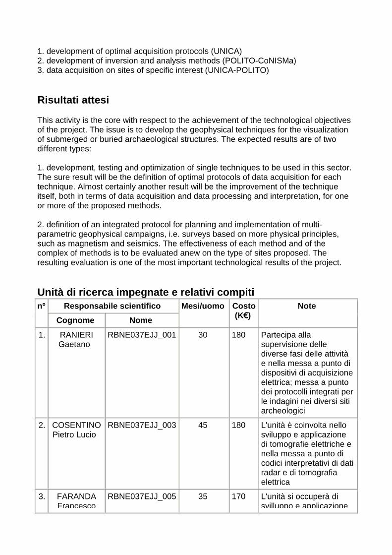
1. development of optimal acquisition protocols (UNICA) 2. development of inversion and analysis methods (POLITO-CoNISMa) 3. data acquisition on sites of specific interest (UNICA-POLITO) Risultati attesi This activity is the core with respect to the achievement of the technological objectives of the project. The issue is to develop the geophysical techniques for the visualization of submerged or buried archaeological structures. The expected results are of two different types: 1. development, testing and optimization of single techniques to be used in this sector. The sure result will be the definition of optimal protocols of data acquisition for each technique. Almost certainly another result will be the improvement of the technique itself, both in terms of data acquisition and data processing and interpretation, for one or more of the proposed methods. 2. definition of an integrated protocol for planning and implementation of multi-parametric geophysical campaigns, i.e. surveys based on more physical principles, such as magnetism and seismics. The effectiveness of each method and of the complex of methods is to be evaluated anew on the type of sites proposed. The resulting evaluation is one of the most important technological results of the project. Unità di ricerca impegnate e relativi compiti
Responsabile scientifico nº
Cognome Nome
Mesi/uomo Costo (K€)
Note
1. RANIERI Gaetano
RBNE037EJJ_001
30 180 Partecipa alla supervisione delle diverse fasi delle attività e nella messa a punto di dispositivi di acquisizione elettrica; messa a punto dei protocolli integrati per le indagini nei diversi siti archeologici
2. COSENTINO Pietro Lucio
RBNE037EJJ_003
45 180 L'unità è coinvolta nello sviluppo e applicazione di tomografie elettriche e nella messa a punto di codici interpretativi di dati radar e di tomografia elettrica
3. FARANDA Francesco
RBNE037EJJ_005
35 170 L'unità si occuperà di svilluppo e applicazione

Maria di metodi sismici ad alta risoluzione per le acquisizioni a mare
4. GODIO Alberto
RBNE037EJJ_004
47 155 L'unità è coinvolta nella fase di sviluppo e applicazione di rilievi magnetici ed elettromagnetici e sviluppo dei relativi codici interpretativi
Attività 3 Informazioni generali
Durata (mesi) Mesi 11
Durata (mesi/uomo) 153
Costo totale previsto 649
Descrizione This activity is focused on the development of methods for the representation of geophysical data, also in the difficult transition conditions between land and sea. The activity will include: 1.Experimentation of the most promising techniques on the site of Lixus (Morocco) and possibly Pollentia (Spain) Voidoikilia (Greece) and Carthage (Tunisia); 2.Development of integration techniques for data coming from aerial and geophysical acquisitions; 3.Three-dimensional representation of magnetic, electromagnetic, GPR and electrical tomography data; 4.Integration of different geophysical methods for the graphical reconstruction of the archaeological landscape 5.Analysis of methods for site value-adding 6.Construction of virtual paths within the reconstructed archaeological landscapes 7.Dissemination of scientific results and development of web sites for the public enjoyment of the results
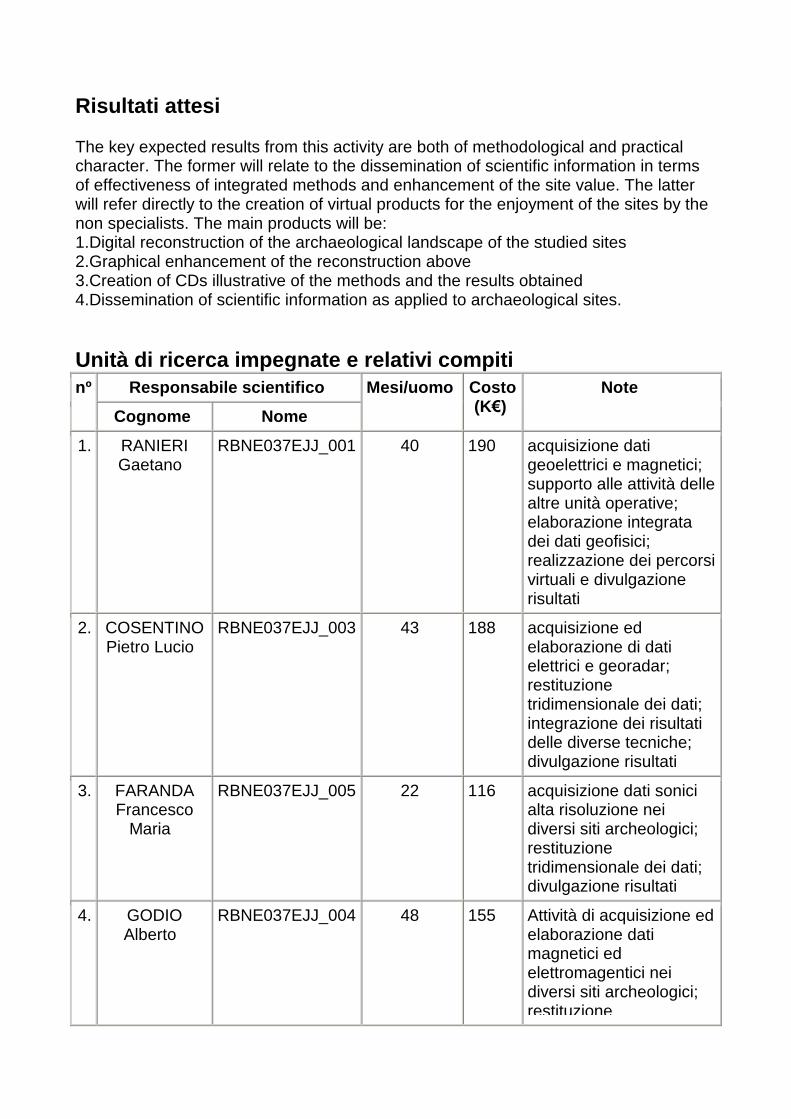
Risultati attesi The key expected results from this activity are both of methodological and practical character. The former will relate to the dissemination of scientific information in terms of effectiveness of integrated methods and enhancement of the site value. The latter will refer directly to the creation of virtual products for the enjoyment of the sites by the non specialists. The main products will be: 1.Digital reconstruction of the archaeological landscape of the studied sites 2.Graphical enhancement of the reconstruction above 3.Creation of CDs illustrative of the methods and the results obtained 4.Dissemination of scientific information as applied to archaeological sites. Unità di ricerca impegnate e relativi compiti
Responsabile scientifico nº
Cognome Nome
Mesi/uomo Costo (K€)
Note
1. RANIERI Gaetano
RBNE037EJJ_001
40 190 acquisizione dati geoelettrici e magnetici; supporto alle attività delle altre unità operative; elaborazione integrata dei dati geofisici; realizzazione dei percorsi virtuali e divulgazione risultati
2. COSENTINO Pietro Lucio
RBNE037EJJ_003
43 188 acquisizione ed elaborazione di dati elettrici e georadar; restituzione tridimensionale dei dati; integrazione dei risultati delle diverse tecniche; divulgazione risultati
3. FARANDA Francesco
Maria
RBNE037EJJ_005
22 116 acquisizione dati sonici alta risoluzione nei diversi siti archeologici; restituzione tridimensionale dei dati; divulgazione risultati
4. GODIO Alberto
RBNE037EJJ_004
48 155 Attività di acquisizione ed elaborazione dati magnetici ed elettromagentici nei diversi siti archeologici; restituzione
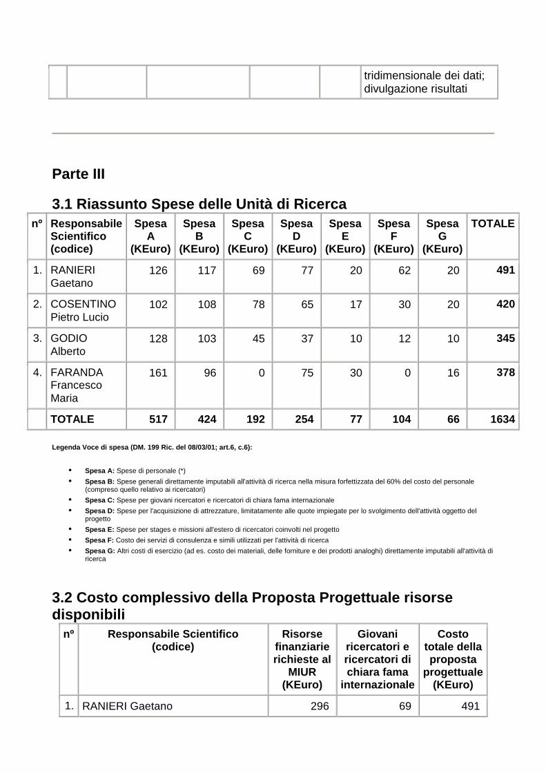
tridimensionale dei dati; divulgazione risultati
Parte III 3.1 Riassunto Spese delle Unità di Ricerca
nº Responsabile Scientifico (codice)
Spesa A
(KEuro)
Spesa B
(KEuro)
Spesa C
(KEuro)
Spesa D
(KEuro)
Spesa E
(KEuro)
Spesa F
(KEuro)
Spesa G
(KEuro)
TOTALE
1. RANIERI Gaetano
126 117 69 77 20 62 20 491
2. COSENTINO Pietro Lucio
102 108 78 65 17 30 20 420
3. GODIO Alberto
128 103 45 37 10 12 10 345
4. FARANDA Francesco Maria
161 96 0 75 30 0 16 378
TOTALE 517 424 192 254 77 104 66 1634
Legenda Voce di spesa (DM. 199 Ric. del 08/03/01; a rt.6, c.6):
• Spesa A: Spese di personale (*)
• Spesa B: Spese generali direttamente imputabili all'attività di ricerca nella misura forfettizzata del 60% del costo del personale (compreso quello relativo ai ricercatori)
• Spesa C: Spese per giovani ricercatori e ricercatori di chiara fama internazionale
• Spesa D: Spese per l'acquisizione di attrezzature, limitatamente alle quote impiegate per lo svolgimento dell'attività oggetto del progetto
• Spesa E: Spese per stages e missioni all'estero di ricercatori coinvolti nel progetto
• Spesa F: Costo dei servizi di consulenza e simili utilizzati per l'attività di ricerca
• Spesa G: Altri costi di esercizio (ad es. costo dei materiali, delle forniture e dei prodotti analoghi) direttamente imputabili all'attività di ricerca
3.2 Costo complessivo della Proposta Progettuale ri sorse disponibili
nº Responsabile Scientifico (codice)
Risorse finanziarie richieste al
MIUR (KEuro)
Giovani ricercatori e ricercatori di chiara fama
internazionale
Costo totale della proposta
progettuale (KEuro)
1. RANIERI Gaetano 296 69 491

2. COSENTINO Pietro Lucio 240 78 420
3. GODIO Alberto 210 45 345
4. FARANDA Francesco Maria 264 0 378
TOTALE 1010 192 1634
A carico del MIUR
A carico del Proponente
TOTALE
Costo delle attività di ricerca 1010 432 1442
Costo dei contratti triennali 192 192
Costo complessivo della Proposta Progettuale
1202 432 1634
Si ricorda che il cofinanziamento a carico del proponente deve essere pari al 30% del costo complessivo della proposta progettuale, detratti i costi dei contratti triennali per giovani ricercatori e per ricercatori di chiara fama, che sono finanziati al 100%. (per la copia da inviare per raccomandata o da consegnare all'accettazione del MIUR e per l'assenso alla diffusione via Internet delle informazioni riguardanti i progetti finanziati e la loro elaborazione necessaria alle valutazioni; legge del 31.12.96 n°675 sulla "Tutela dei dati personali") Certifico, sotto la mia personale responsabilità, di aver ottenuto regolare autorizzazione dal rappresentante legale dell'ente di mia appartenenza, nonchè degli enti di tutte le altre Unità di Ricerca. Firma del Coordinatore ............................. Firma del Rappresentante legale .............................
Data 13/02/2004 15:27
.