Matera, 19-20 Febbraio 2016 -...
3
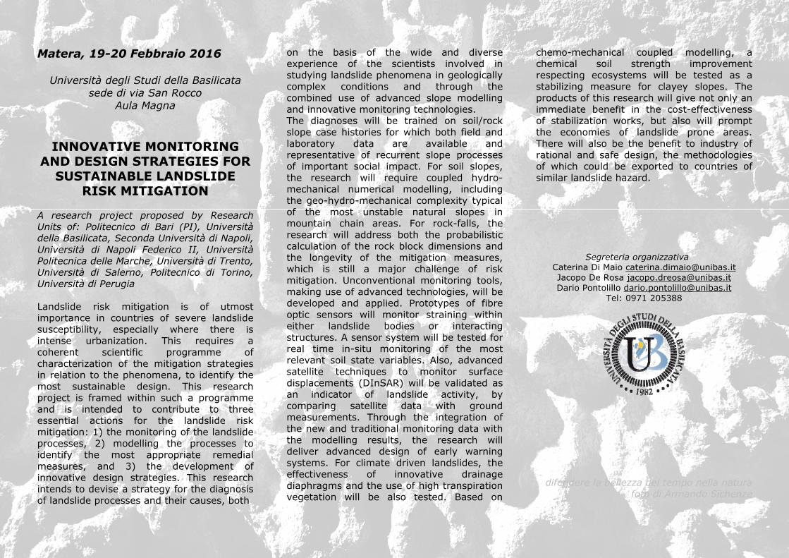
Matera, 19-20 Febbraio 2016 Università degli Studi della Basilicata sede di via San Rocco Aula Magna INNOVATIVE MONITORING AND DESIGN STRATEGIES FOR SUSTAINABLE LANDSLIDE RISK MITIGATION A research project proposed by Research Units of: Politecnico di Bari (PI), Università della Basilicata, Seconda Università di Napoli, Università di Napoli Federico II, Università Politecnica delle Marche, Università di Trento, Università di Salerno, Politecnico di Torino, Università di Perugia Landslide risk mitigation is of utmost importance in countries of severe landslide susceptibility, especially where there is intense urbanization. This requires a coherent scientific programme of characterization of the mitigation strategies in relation to the phenomena, to identify the most sustainable design. This research project is framed within such a programme and is intended to contribute to three essential actions for the landslide risk mitigation: 1) the monitoring of the landslide processes, 2) modelling the processes to identify the most appropriate remedial measures, and 3) the development of innovative design strategies. This research intends to devise a strategy for the diagnosis of landslide processes and their causes, both on the basis of the wide and diverse experience of the scientists involved in studying landslide phenomena in geologically complex conditions and through the combined use of advanced slope modelling and innovative monitoring technologies. The diagnoses will be trained on soil/rock slope case histories for which both field and laboratory data are available and representative of recurrent slope processes of important social impact. For soil slopes, the research will require coupled hydro- mechanical numerical modelling, including the geo-hydro-mechanical complexity typical of the most unstable natural slopes in mountain chain areas. For rock-falls, the research will address both the probabilistic calculation of the rock block dimensions and the longevity of the mitigation measures, which is still a major challenge of risk mitigation. Unconventional monitoring tools, making use of advanced technologies, will be developed and applied. Prototypes of fibre optic sensors will monitor straining within either landslide bodies or interacting structures. A sensor system will be tested for real time in-situ monitoring of the most relevant soil state variables. Also, advanced satellite techniques to monitor surface displacements (DInSAR) will be validated as an indicator of landslide activity, by comparing satellite data with ground measurements. Through the integration of the new and traditional monitoring data with the modelling results, the research will deliver advanced design of early warning systems. For climate driven landslides, the effectiveness of innovative drainage diaphragms and the use of high transpiration vegetation will be also tested. Based on chemo-mechanical coupled modelling, a chemical soil strength improvement respecting ecosystems will be tested as a stabilizing measure for clayey slopes. The products of this research will give not only an immediate benefit in the cost-effectiveness of stabilization works, but also will prompt the economies of landslide prone areas. There will also be the benefit to industry of rational and safe design, the methodologies of which could be exported to countries of similar landslide hazard. Segreteria organizzativa Caterina Di Maio [email protected] Jacopo De Rosa [email protected] Dario Pontolillo [email protected] Tel: 0971 205388 difendere la bellezza del tempo nella natura foto di Armando Sichenze
Transcript of Matera, 19-20 Febbraio 2016 -...
Matera, 19-20 Febbraio 2016
Università degli Studi della Basilicata sede di via San Rocco
Aula Magna
INNOVATIVE MONITORING AND DESIGN STRATEGIES FOR
SUSTAINABLE LANDSLIDE RISK MITIGATION
A research project proposed by Research Units of: Politecnico di Bari (PI), Università della Basilicata, Seconda Università di Napoli, Università di Napoli Federico II, Università Politecnica delle Marche, Università di Trento, Università di Salerno, Politecnico di Torino, Università di Perugia Landslide risk mitigation is of utmost importance in countries of severe landslide susceptibility, especially where there is intense urbanization. This requires a coherent scientific programme of characterization of the mitigation strategies in relation to the phenomena, to identify the most sustainable design. This research project is framed within such a programme and is intended to contribute to three essential actions for the landslide risk mitigation: 1) the monitoring of the landslide processes, 2) modelling the processes to identify the most appropriate remedial measures, and 3) the development of innovative design strategies. This research intends to devise a strategy for the diagnosis of landslide processes and their causes, both
on the basis of the wide and diverse experience of the scientists involved in studying landslide phenomena in geologically complex conditions and through the combined use of advanced slope modelling and innovative monitoring technologies. The diagnoses will be trained on soil/rock slope case histories for which both field and laboratory data are available and representative of recurrent slope processes of important social impact. For soil slopes, the research will require coupled hydro-mechanical numerical modelling, including the geo-hydro-mechanical complexity typical of the most unstable natural slopes in mountain chain areas. For rock-falls, the research will address both the probabilistic calculation of the rock block dimensions and the longevity of the mitigation measures, which is still a major challenge of risk mitigation. Unconventional monitoring tools, making use of advanced technologies, will be developed and applied. Prototypes of fibre optic sensors will monitor straining within either landslide bodies or interacting structures. A sensor system will be tested for real time in-situ monitoring of the most relevant soil state variables. Also, advanced satellite techniques to monitor surface displacements (DInSAR) will be validated as an indicator of landslide activity, by comparing satellite data with ground measurements. Through the integration of the new and traditional monitoring data with the modelling results, the research will deliver advanced design of early warning systems. For climate driven landslides, the effectiveness of innovative drainage diaphragms and the use of high transpiration vegetation will be also tested. Based on
chemo-mechanical coupled modelling, a chemical soil strength improvement respecting ecosystems will be tested as a stabilizing measure for clayey slopes. The products of this research will give not only an immediate benefit in the cost-effectiveness of stabilization works, but also will prompt the economies of landslide prone areas. There will also be the benefit to industry of rational and safe design, the methodologies of which could be exported to countries of similar landslide hazard. Segreteria organizzativa
Caterina Di Maio [email protected] Jacopo De Rosa [email protected] Dario Pontolillo [email protected]
Tel: 0971 205388
difendere la bellezza del tempo nella natura foto di Armando Sichenze
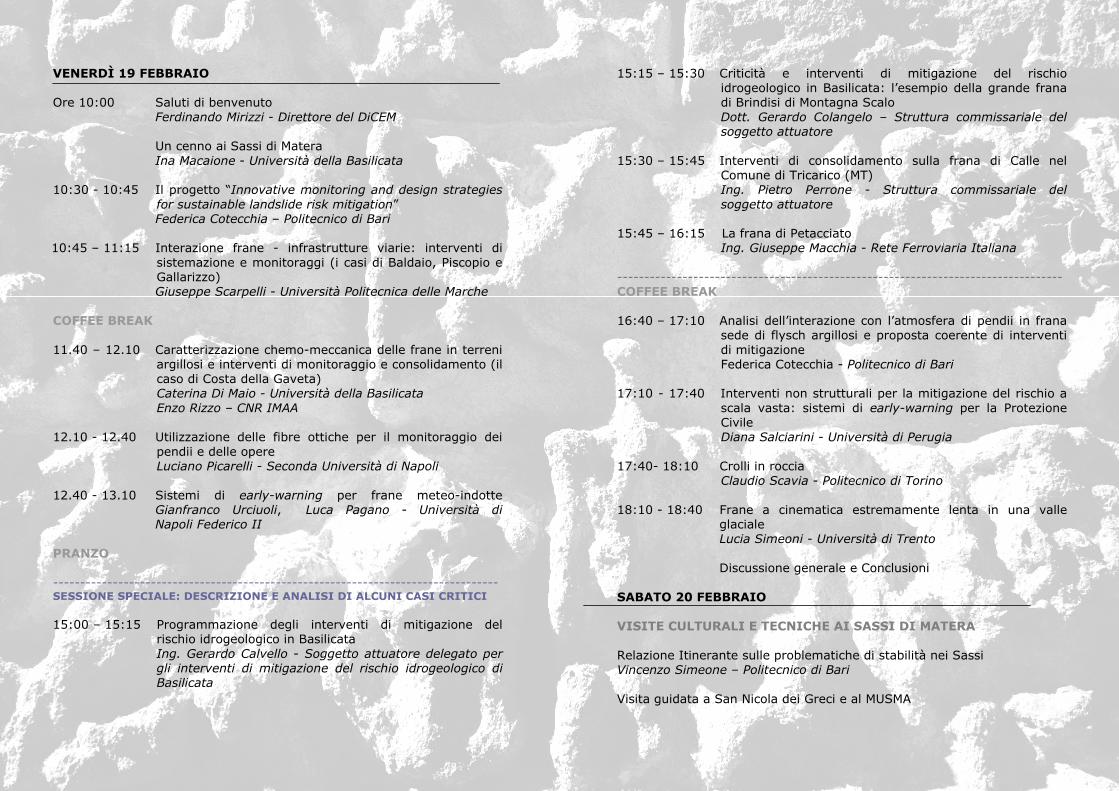
VENERDÌ 19 FEBBRAIO Ore 10:00 Saluti di benvenuto Ferdinando Mirizzi - Direttore del DiCEM Un cenno ai Sassi di Matera Ina Macaione - Università della Basilicata 10:30 - 10:45 Il progetto “Innovative monitoring and design strategies
for sustainable landslide risk mitigation” Federica Cotecchia – Politecnico di Bari 10:45 – 11:15 Interazione frane - infrastrutture viarie: interventi di
sistemazione e monitoraggi (i casi di Baldaio, Piscopio e Gallarizzo) Giuseppe Scarpelli - Università Politecnica delle Marche
COFFEE BREAK 11.40 – 12.10 Caratterizzazione chemo-meccanica delle frane in terreni
argillosi e interventi di monitoraggio e consolidamento (il caso di Costa della Gaveta) Caterina Di Maio - Università della Basilicata Enzo Rizzo – CNR IMAA
12.10 - 12.40 Utilizzazione delle fibre ottiche per il monitoraggio dei
pendii e delle opere Luciano Picarelli - Seconda Università di Napoli
12.40 - 13.10 Sistemi di early-warning per frane meteo-indotte
Gianfranco Urciuoli, Luca Pagano - Università di Napoli Federico II
PRANZO ---------------------------------------------------------------------------------- SESSIONE SPECIALE: DESCRIZIONE E ANALISI DI ALCUNI CASI CRITICI 15:00 – 15:15 Programmazione degli interventi di mitigazione del
rischio idrogeologico in Basilicata Ing. Gerardo Calvello - Soggetto attuatore delegato per gli interventi di mitigazione del rischio idrogeologico di Basilicata
15:15 – 15:30 Criticità e interventi di mitigazione del rischio idrogeologico in Basilicata: l’esempio della grande frana di Brindisi di Montagna Scalo Dott. Gerardo Colangelo – Struttura commissariale del soggetto attuatore
15:30 – 15:45 Interventi di consolidamento sulla frana di Calle nel
Comune di Tricarico (MT) Ing. Pietro Perrone - Struttura commissariale del soggetto attuatore
15:45 – 16:15 La frana di Petacciato
Ing. Giuseppe Macchia - Rete Ferroviaria Italiana ---------------------------------------------------------------------------------- COFFEE BREAK 16:40 – 17:10 Analisi dell’interazione con l’atmosfera di pendii in frana
sede di flysch argillosi e proposta coerente di interventi di mitigazione Federica Cotecchia - Politecnico di Bari
17:10 - 17:40 Interventi non strutturali per la mitigazione del rischio a scala vasta: sistemi di early-warning per la Protezione Civile Diana Salciarini - Università di Perugia
17:40- 18:10 Crolli in roccia
Claudio Scavia - Politecnico di Torino 18:10 - 18:40 Frane a cinematica estremamente lenta in una valle glaciale Lucia Simeoni - Università di Trento
Discussione generale e Conclusioni SABATO 20 FEBBRAIO VISITE CULTURALI E TECNICHE AI SASSI DI MATERA
Relazione Itinerante sulle problematiche di stabilità nei Sassi Vincenzo Simeone – Politecnico di Bari Visita guidata a San Nicola dei Greci e al MUSMA

difendere la bellezza del tempo nella natura
foto di Armando Sichenze