Congresso GeoSed - perso-sdt.univ-brest.frjacdev/pdf/geosed_bari08.pdf · G. Cantalamessa, C. Di...
140
Transcript of Congresso GeoSed - perso-sdt.univ-brest.frjacdev/pdf/geosed_bari08.pdf · G. Cantalamessa, C. Di...


2

Congresso GeoSed 25-26 Settembre 2008
Aula Magna Palazzo di Scienze della Terra
Campus Universitario Via E. Orabona 4
BARI
Atti del Congresso a cura di:
Massimo Moretti

4
ORGANIZZAZIONE
Coordinamento Luisa Sabato
Segreteria Luigi Spalluto
Comitato organizzatore Salvatore Gallicchio
Massimo Moretti Luisa Sabato Luigi Spalluto
Marcello Tropeano
Collaboratori Alessia Barchetta Elisa Costantini
Antonietta Cilumbriello Antonio Grippa
Michele Labriola Rosanna Laragione
Stefania Lisco Vincenzo Onofrio Mariangela Pepe
Patrocinio e Contributo Università degli Studi di Bari
Dipartimento di Geologia e Geofisica Dottorato di Scienze della Terra
Regione Puglia Regione Basilicata Provincia di Bari Comune di Bari
Commissione Italiana “Anno Internazionale del Pianeta Terra”

INDICE DEL VOLUME G. Aiello, A. Conforti, B. D’Argenio
Regional marine geologic cartography of the Naples Bay (scale 1:10.000): the geological map n. 465 “Procida” pag. 1 G. Aiello, E. Marsella, S. Passaro
The continental slopes off the Ischia island (Naples Bay): submarine gravity instability processes investigated by means of marine geological and geophysical data pag. 4 M. Aldinucci, I. Martini, F. Sandrelli The Pliocene deposits of the northern Siena Basin (Tuscany, Italy) revised through unconformity-bounded stratigraphic units pag. 6 A. Alfarano, M. Delle Rose, L. Orlanducci, F. Resta Rapporti stratigrafici tra pietra leccese, piromafo e Calcareniti di Andrano (area urbana e periferia est di Lecce) pag. 8 S. Andreucci, V. Pascucci, M. D. Bateman Record of three peaks during the Marine Isotopic Stage MIS5 along the Alghero coast, NW Sardinia, Italy: Sea level implication
pag. 10 A. Barchetta, L. Spalluto Stratigrafia e caratteri di facies delle successioni carbonatiche affioranti nell’area compresa tra Binetto e Grumo Appula (Murge baresi, Puglia) pag. 12 M. Bertacchini, P. Fregni New observations on the Perugia Hill rock substrate pag. 14 D. Bertoni, G. Sarti Morphodynamic evolution of an artificial pebble beach in a ten months span; Marina di Pisa, Tuscany, Italy: preliminary data pag. 15 M. Brandano Shift in the Mg/Ca ratio of seawater from Cretaceous to Holocene: insights from coralline algae
pag. 17 M. Brandano, F. Jadoul, L. Tomassetti, F. Berra, A. Lanfranchi, M. R. Petrizzo Stratigraphic architecture of the Bonifacio Basin (South Corsica, Early-Middle Miocene) pag. 18 S. Bravi, G. Carannante, I. Masucci, F. Pomoni-Papaioannou, L. Simone Dry and warm climatic conditions witnessed by sabkha-related evaporitic cycles in the “Middle Cretaceous” limestone of Southern Apennines pag. 19 L. Cabrera, M. Garcés , F. J. Pérez Rivarés, J. Cruz Larrasoaña, X. Murelaga , C. Arenas, G. Pardo Unraveling tectonic-paleoclimatic cyclicity from alluvial-lacustrine sequences? Integrated magnetostratigraphic and sedimentological approach
pag. 22 G. Cantalamessa, C. Di Celma, M. Potetti, P. Lori, G. Napoleone, A. Albianelli Climatic control on deposition of Middle to Upper Pliocene deepwater strata in the Apennines foredeep (central Italy): correlations to the marine oxygen isotope record
pag. 26 A. Cattaneo, N. Sultan, R. Silva Jacinto, B. Savoye, G. Dan, A. Nouguès, K. Yelles, N. Babonneau, P. Strzerzynski, J. Déverchère Multi-parametric analysis of submarine slides on the Algerian continental slope (Western Mediterranean)
pag. 27
6
D. Chiarella, S. Longhitano Pliocene mixed arenites in the Acerenza area (Basilicata, southern Italy): facies characteristics and implications for depositional processes and environments pag. 30 N. Ciaranfi, A. D'Alessandro, A. Girone, F. Lirer, L. Lirer, P. Maiorano, M. Marino, N. Pelosi, P. Petrosino, L. Sagnotti, M. Sprovieri, S. Stefanelli The Lower-Middle Pleistocene Montalbano Jonico Section in the Southern Apennine Foredeep pag. 32 A. Cilumbriello
Sequence-stratigraphic interpretation of the Marine terraced deposits in the hinterland of the Taranto Gulf pag. 34 A. Cilumbriello, L. Sabato, M. Tropeano I depositi di chiusura del ciclo bradanico: problemi interpretativi e cartografici pag. 36 I. Ciociaro, I. Di Giorgio, G. Robustelli, M. Sonnino Le successioni conglomeratiche del bordo occidentale del Bacino del Mercure (Pleistocene, Appennino Calabro-Lucano) pag. 37 D. Cosentino, F. Castorina, P. Cipollari, G. Fubelli Pliocene paleoshorelines and uplift rates at the Tyrrhenian margin of central Apennines (Italy)
pag. 39 A. d'Atri, D. Varrone Rhodoliths and Acervulinid macroids: useful tools to evaluate water energy in ramp settings
pag. 42 M. Delle Rose The Chattian-Messinian Salento super-sequence and its relation with tectonic and paleoclimate pag. 44 M. Delle Rose Eustatic-climate versus tectonic control of Pliocene-lower Pleistocene sequence stratigraphic surfaces (Salento, south Italy) pag. 47 C. Di Celma, R. Brunt, D. Hodgson, J. Kavanagh, S. Flint Architecture and depositional evolution of a Permian slope channel-levee system: Unit D of the Laingsburg Formation, Karoo basin, South Africa pag. 50 L. A. Dimuccio, T. Aubry Karstic archaeostratigraphic record in Central Portugal: characterizing and interpreting sedimentary unconformities pag. 51 E. Dinelli, V. Laterza, G. Sarti Geochemical analysis of the upper shoreface sediments between Livorno and the Serchio River (Tuscany): a focus on heavy metals pag. 53 R. Dominici, M. Sonnino Ambienti sedimentari della Formazione di Stilo - Capo d'Orlando (Miocene inf.) in Calabria pag. 54 E. Fiore, P. Donato, M. Sonnino Composizione e provenienza di depositi vulcanoclastici nel Bacino del Mércure (Pleistocene, Appennino Calabro-Lucano) pag. 56 S. Gallicchio, L. Sabato, I. Premoli Silva, P. Scotti, G. Salvini Cretaceous black shale horizons in a deep-sea siliceous sedimentary succession of the Tethys along the western part of the Adria Plate. (Southern Apennines, Italy) pag. 59

F. Gamberi, M. Marani, E. Leidi Leveed channel evolution and basin plain depositional style: the case of the Capo D’Orlando Basin (South-eastern Tyrrhenian Sea) pag. 60 A. Grippa Confronto tra depositi sabbioso-ghiaiosi di spiagge fossili ed attuali presenti nell’area metapontina pag. 61 U. Haq A New Model of Paleozoic Eustasy pag. 63 U. Haq Oxygen Isotopes versus Ice Volume: Problems of Estimating Magnitude of Sea-Level Changes in the Past pag. 64 A. Iadanza, G. Sampalmieri, P. Cipollari, D. Cosentino The “Calcare di Base” of Rossano Basin (Calabria): microfacies and natural radioactivity data
pag. 65 M. Labriola, V. Onofrio, S. Gallicchio, M. Tropeano Features of the outcropping south Apennines front between Acerenza and Oppido Lucano (Basilicata - Italy) pag. 67 D. Liotta, A. Brogi Miocene basins in southern Tuscany: extension vs. compression pag. 69 S. Lisco Studio stratigrafico integrato tra analisi di facies e analisi biostratigrafiche dei depositi torbiditici affioranti nei dintorni di Pietrapertosa (Pz), Italia meridionale pag. 70 S. Longhitano Could an eterolithic substrate have influenced the depositional architectures of coarse-grained Gilbert-type deltas during their progradation? A case-study from the Pliocene Potenza Basin (Southern Italy) pag. 72 S. Longhitano, L. Sabato, M. Tropeano Evolution and dynamics of flood-tidal clinoforms within mixed bioclastic/siliciclastic sandstones of a Pliocene thrust-top basin (Tricarico, Southern Apennines, Italy) pag. 74 V. Manzi, S. Lugli, M. Roveri Sr isotope curve re-calibration based on new Messinian salinity crisis age model
pag. 76 S. Mecozzi, S. Conti, D. Fontana Fluid expulsion and typology of seep-carbonates in the northern Apennines pag. 78 M. Moretti, L. Spalluto Neotectonic features (Pliocene-late Pleistocene) in the western sector of the Gargano Promontory (Apulian foreland, southern Italy) pag. 80 P. Muzzi Magalhaes, R. Tinterri, J.P.B.C. Guerreiro, J.S. Oliveira Filho, G. Basta Sedimentology of the Langhian to Serravallian turbidite deposits of the Marnoso-arenacea Formation (northern Apennines, Italy) pag. 82 P. Muzzi Magalhaes, R. Tinterri, J.P.B.C. Guerreiro, J.S. Oliveira Filho, G. Basta High-resolution stratigraphy of the Langhian to Serravallian portion of the Marnoso-arenacea Formation (northern Apennines, Italy) pag. 86

8
P. Muzzi Magalhaes, R. Tinterri, J.P.B.C. Guerreiro, J.S. Oliveira Filho, G. Basta New preliminary data about the Verghereto Marls (Serravallian-Tortonian, Marnoso-arenacea Formation, northern Apennines, Italy) pag. 91 V. Onofrio Stratigraphy of the northern sector of Sant’Arcangelo Basin: new costraints for the tectonic-sedimentary evolution of a Plio-Pleistocene wedge-top basin in southern apennines (Italy) pag. 94 V. Pascucci, L. Bittau Evoluzione di una pocket beach pag. 96 M. Pepe Caratteri deposizionali delle successioni plioceniche di “wedge-top basin” affioranti tra gli abitati di San Mauro Forte, Oliveto Lucano e Garaguso (MT, Italia meridionale) pag. 100 P. Pieri The Apulian Foreland and the Calcarenite di Gravina Formation pag. 102 P. Pieri, L. Spalluto Geology of the F° 438 “Bari” (CARG Puglia – new Geologic map of Italy, scale 1: 50.000) pag. 103 S. Piovan, P. Mozzi Holocene palaeohydrography and stratigraphy of the south Venetian Plain pag. 105 I. Premoli Silva Gli eventi anossici del medio Cretacico e loro significato a scala globale pag. 108 M. Roveri, S. Lugli, V. Manzi
Large-scale mass wasting processes in the Messinian Ciminna Basin (northern Sicily)
pag. 110 D. Ruberti, M. Vigliotti, R. Marzaioli, A. Pacifico Caratterizzazione geoambientale del margine nordest della Piana Campana in provincia di Caserta pag. 112 M. Sacchi, F. Molisso, C. Violante, E. Esposito, D. Insinga, C. Lubritto, S. Porfido, T. Tóth
Insights into flood-dominated, mixed siliciclastic-volcaniclastic fan deltas: very high-resolution seismic examples off the Amalfi cliffed coast, Eastern Tyrrhenian Sea pag. 114 G. Sarti, D. Bertoni, L. Ciulli, I. Consoloni, S. Giacomelli - A threefold research aimed at the reconstruction of an artificial dune (Migliarino – San Rossore – Massaciuccoli National Park, Pisa, Tuscany, Italy): preliminary data pag. 117 L. B. Teruggi, M. Rinaldi, D. Ostuni, I. Chiaverini Quantificazione dell’apporto di sedimenti provenienti dall’erosione delle sponde del fiume Cecina pag. 118 L. B. Teruggi, S. Sala, M. J. Kristensen, E. Caporali, M. A. Casco, A. Cefarelli Classification of ecological status of the Río Quequén Grande basin, Buenos Aires, Argentina pag. 121 C. Viseras , F. García-García Siliciclastic vs carbonate sedimentation in shallow-marine systems: models of Neogene deltas in the Betic Cordillera pag. 124 M. Zecchin, M. Caffau Stratal architecture and evolution of a Pleistocene, coarse-grained submarine canyon fill (Crotone Basin, Southern Italy) pag. 127

RIASSUNTI
ABSTRACTS


GEOSED 2008 – BARI 23-27/09/08 – ABSTRACTS ----------------------------------------------------------------------
1
Regional marine geologic cartography of the Naples Bay (scale 1:10.000): the geological map n. 465 “Procida”
G. Aiello
1, A. Conforti
1 and B. D’Argenio
1-2 1 Istituto per l’Ambiente Marino Costiero, Consiglio Nazionale delle Ricerche, Calata Porta di Massa, Porto di
Napoli, 80133, Napoli, Italy 2 Università degli Studi di Napoli “Federico II”, Dipartimento di Scienze della Terra, L.go S. Marcellino 10,
80133, Napoli, Italy
The Geomare Sud Institute, National Research Council of Italy, now Institute of Coastal Marine Environment has carried out a marine geological survey of the Campania region (CARG Project) for the construction of experimental geological maps committed from the National Geological Survey of Italy, now APAT (Agency for the Protection of the Environment and the Technical Services). Later, from the 2003 the Regional Geological Survey of Campania committed to the same Institute also the marine geological mapping of the Naples and Salerno Bays at the scale 1:10.000 (Scientific Responsible for the Region: L. Monti; Scientific Responsible for the CNR-IAMC: E. Marsella). Some criteria and examples of marine geological mapping relative to the geological map n. 465 “Procida” at the scale 1:10.000 (Director of Survey: G. Aiello) are here presented (fig. 1).
Several geological and geophysical surveys of the continental shelf and slope of the Naples
Bay have been carried out (geological map n. 465 “Procida”). In particular, a high resolution Multibeam bathymetry of the Naples Bay allowed for the construction of a marine DEM (Digital Elevation Model) of the area, giving a detailed image of the morpho-structures at the sea bottom (D’Argenio et al., 2004). Moreover, Sidescan Sonar acoustic profiles covering the whole Naples Bay have been acquired for the construction of photomosaics of the sea bottom. The Sidescan

GEOSED 2008 – BARI 23-27/09/08 – ABSTRACTS ----------------------------------------------------------------------
2
Sonar photomosaics and the Multibeam bathymetry represented the base for the marine geological mapping.
The integrated geological interpretation of seismic, bathymetric and Sidescan Sonar data has been tied by sea bottom samples and piston cores. The geological structures and the seismic sequences, both volcanic and sedimentary in nature, which characterize the Naples Bay at a regional scale have been the object of detailed studies carried out by using multichannel and single channel seismics of various resolution and penetration, including the Subbottom Chirp profiles, often integrated with marine magnetics (Aiello et al., 2001; Secomandi et al., 2003; Aiello et al., 2004; 2005; D’Argenio et al., 2004; Ruggieri et al., 2007).
The interpretation of high resolution seismic reflection profiles (Subbottom Chirp, Sparker and Watergun) has supported the reconstruction of stratigraphic and structural framework of the continental shelf and slope successions. The seismo-stratigraphic analysis allowed to distinguish the main volcanic and sedimentary seismic units, separated by regional unconformities, tectonically and eustatically controlled. The Dohrn and the Magnaghi canyons, eroding the slope up to 1000 m of water depth, represent in the Naples Bay important morpho-structural lineaments, at the boundary between the sedimentary units of the eastern shelf of the Naples Bay and the volcanic units of the western shelf, in correspondence to the Ischia and Procida islands.
The complex stratigraphic architecture of the Naples Bay has revealed, during the Late Quaternary, a strong control of the volcano-tectonic processes in triggering submarine gravity instabilities. This regional geological framework didn’t allow a simple application of principles and techniques of seismic and sequence stratigraphy, as described in the guidelines for the redaction of marine geologic cartography (Catalano et al., 1996; Fabbri et al., 2002). The realised cartographic approach, however experimental, is based on the recognition of laterally coeval depositional systems, representing portions of system tracts of the Late Quaternary Depositional Sequence (SDTQ in Catalano et al., 1996).
The seismic units have been later interpreted in terms of depositional sequences and corresponding unconformities have been interpreted as Type 1 or Type 2 sequence boundaries and/or as local unconformities, mainly at the top of relic volcanic edifices or at the top of volcanic seismic units (D’Argenio et al., 2004; Aiello et al., 2005; Ruggieri et al., 2007).
The marine geological map, realised based on the previously mentioned criteria shows the distribution of several lithostratigraphic units cropping out at the sea bottom and of the main morphological lineaments, based on the CARG guidelines for the realization of marine cartography (Catalano et al., 1996; Fabbri et al., 2002).
The main stratigraphic units individuated through the analysis of sea bottom sediments belong to the Late Quaternary Depositional Sequence; in this sequence it is possible to recognise the space and time evolution and the lateral and vertical migration of marine coastal, continental shelf and slope depositional environments in the Late Pleistocene-Holocene glacio-eustatic cycle. The stratigraphic succession studied by geological survey has registered the variations of the accommodation space of the Late Quaternary deposits during the last 4th order glacio-eustatic cycle, ranging between 128 ky B.P. (“Tyrrhenian” stage) and the present (isotopic stage Q5e in Catalano et al. 1996).
One aim of the cartography has been the cartographic representation of the lithofacies associations, whose grouping form the “depositional elements” (which are portions of system tracts), in relation to the morpho-structural lineaments recognised through the geological interpretation of the geophysical data and the dynamics of depositional environments.
In this way, we tried to realise an integration between classical stratigraphic approach, sequence stratigraphic approach and characterization of actual and recent depositional elements. The volcanic activity, which has mainly controlled the stratigraphic architecture of the Naples Bay prevented a classical stratigraphic approach in the marine geological mapping, which has been realised taking into account both the associations of depositional systems and the interstratified volcanic bodies (volcanites and volcanoclastites).
Moreover, this cartographic approach allowed to obtain informations comparable with other sectors of the Italian continental margins. The last Quaternary sea level rise, having an excursion of about 120 m and a maximum rate in the order of 10 m/1000 years has left a stratigraphic signature on the morphological and stratigraphic framework of most continental margins of the world (Chappell and Shackleton, 1986). The deposits associated to this process are strongly
GEOSED 2008 – BARI 23-27/09/08 – ABSTRACTS ----------------------------------------------------------------------
3
different in the various areas, as a function of different sedimentary supply, morphological framework and oceanographic regimes; to map these deposits allows to correlate the unconformities (erosional and non-depositional) and to compare the facies, the internal geometries and the thickness of the deposits registering the sea level rise in a differential way on the several margins.
The key of the geological map n. 465 “Procida” includes the description of the geologic and morphologic elements. The areal geological elements are represented by two superimposed levels: the textural classes distinguished following the classification of Folk (1954), graphically distinguished with halftone screens; the depositional elements, distinguished with the full colour. The superimposition of the environmental information on the textural one allows for a more complete reading of the cartography, furnishing at the same time geological and environmental information. The morphological elements, both areal and linear represent another level of graphic superimposition to the geological informations.
Several volcanic units of substrate have been distinguished, cropping out between the Procida island, the promontories of Monte di Procida and Capo Miseno and the coastal cliffs off Nisida and Posillipo (Naples town), of a carbonate unit of substrate, cropping out in the Sorrento Peninsula off Massalubrense and of undifferentiated carbonate and volcanic substrates, distinguished in the offshore area based on geophysics. REFERENCES Aiello G., Budillon F. et al., 2001. Marine geology and morphobathymetry in the Bay of Naples. In Faranda F.M., Guglielmo L. and Spezie G. (Eds.) Structures and processes of the Mediterranean ecosystems. Springer-Verlag Italy, pp. 1-8. Aiello G., Angelino A., Marsella E., Ruggieri S. e Siniscalchi A., 2004. Carta magnetica di alta risoluzione del Golfo di Napoli (Tirreno meridionale). Boll. Soc. Geol. Ital., 123, 333-342. Aiello G., Angelino A., D’Argenio B., Marsella E., Pelosi N., Ruggieri S., Siniscalchi A., 2005. Buried volcanic structures in the Gulf of Naples (Southern Tyrrhenian sea, Italy) resulting from high resolution magnetic survey and seismic profiling. Annals of Geophysics, 48, 1-15. Catalano R., et al., 1996. Linee guida alla cartografia geologica marina, scala 1:50.000. Gruppo di Lavoro del Servizio Geologico Nazionale, Bozza n. 1 Chappell J. and Shackleton N.J., 1986. Oxygen isotopes and sea level. Nature, 324, 137-140. D’Argenio B., Aiello G. et al., 2004. Digital elevation model of the Naples Bay and adjacent areas, Eastern Tyrrhenian sea. In: Atlante di Cartografia Geologica scala 1:50.000 (progetto CARG), Servizio Geologico d’Italia (APAT), 32nd International Congress “Firenze 2004”, Editore De Agostini, Italy. Fabbri A., Argnani A., Bortoluzzi G., Correggiari A., Gamberi F., Ligi M., Marani M., Penitenti D., Roveri M. e Trincardi F. , 2002. Carta geologica dei mari italiani alla scala 1:250.000. Guida al rilevamento. Presidenza del Consiglio dei Ministri, Dipartimento per i Servizi Tecnici Nazionali, Servizio Geologico, Quaderni serie III, volume 8. Ruggieri S., Aiello G., Marsella E., 2007. Integrated marine geophysical data interpretation of the Naples Bay continental slope. Boll. Geof. Teor. Appl., 48, 1-24. Secomandi M., Paoletti V., Aiello G., Fedi M., Marsella E., Ruggieri S., D’Argenio B., Rapolla A., 2003. Analysis of the magnetic anomaly field of the volcanic district of the Bay of Naples, Italy. Marine Geophysical Researches, 24, 207-221.

GEOSED 2008 – BARI 23-27/09/08 – ABSTRACTS ----------------------------------------------------------------------
4
The continental slopes off the Ischia island (Naples Bay): submarine gravity instability processes investigated by means of marine geological
and geophysical data
G. Aiello, E. Marsella and S. Passaro Istituto per l’Ambiente Marino Costiero, Consiglio Nazionale delle Ricerche, Calata Porta di Massa, Porto di
Napoli, 80133, Napoli, Italy
The continental slope offshore the Campania region (Southern Tyrrhenian sea, Italy) represents a natural laboratory to study geological events and processes related to submarine gravity instabilities in deep waters, as a base to evaluate geological and environmental hazards triggered by earthquakes, volcanic eruptions and tectonic activity in correspondence to regional faults. The identification of submarine instabilities on continental slopes shows important implications in terms of applied research for the coastal zone knowledge and management, also in terms of geological and environmental hazard. This study is carried out by using marine geophysical data collected by the CNR-IAMC Institute of Naples, Italy, in particular Multibeam bathymetry and reflection seismics (Sparker Multitip seismic source).
The Ischia island lies on a volcanic ridge showing a mainly E-W trending elongment. In the western offshore of the island a strong field of magnetic anomalies suggests the occurrence of a magmatic system, now inactive. Two main structural trends exist in the E-W trending volcanic ridge of the Ischia island: one E-W trending and another ENE-WSW trending, recognised especially in the western offshore of the island. At a regional scale the comparison between the distribution of magnetic sources and the morpho-structures indicate a poor correlation for the E-W trending morphostructures and a high correlation for the ENE-WSW (Bruno et al., 2002; Passaro, 2005).
Main work methodologies and steps include the acquisition and the processing of Multibeam bathymetry according to the IHO standards (IHO, 1998), the generation of a marine DEM (Digital Elevation Model), its morpho-structural geological interpretation and integrated interpretation of bathymetry and reflection seismics.
A Digital Elevation Model (DEM) of the Ischia island based on Multibeam bathymetric survey and integrated to onshore topography is shown in fig. 1. The geological interpretation of the marine DEM of the island allows the identification of the main morpho-structural features of the sea bottom. Spectacular features characterize the continental slope off the south-western Ischia island, incised by a dense network of canyons and tributary channels, starting from a retreating shelf break, parallel to the coastline and located at varying depths. Large scars characterize the platform margin off the south-western Ischia island, in particular the scar of the southern flank of the island, corresponding onshore to the M.te Epomeo block and originating the Ischia Debris Avalanche (IDA; Chiocci and de Alteriis, 2006). Volcanic banks having irregular morphologies are identifiable in the south-western flanks of the island, as the “Banco di Capo Grosso”, a complex morphostructural high located on the southern continental slope.

GEOSED 2008 – BARI 23-27/09/08 – ABSTRACTS ----------------------------------------------------------------------
5
The marine DEM shows the relic morphology of the “Banco di Ischia”, a wide terraced volcanic bank located on the south-eastern flank of the island. Moreover, several volcanic highs are disposed along two main ridges. The first ridge, NE-SW trending, is about 10 kilometres and includes several morphological highs located in the south-western Ischia offshore at water depths ranging from – 800 m and – 100 m (“Banco Rittmann”, “Banco G. Buchner”, “Banco P. Buchner”, “Banco di Forio”). The top of the Banco di Forio tuff cone occurs at water depths of about – 30 m. The second ridge, E-W trending, starts in the north-western Ischia offshore at water depths of about – 600 m (from the “Banco Pithecusa” and the “Banco Mazzella”) and continues up to the coastal sectors of the island.
The submerged sectors of the Ischia island are the site of submarine gravity instability processes, having catastrophic (instantaneous) characters (debris avalanches) or continuous characters (accelerated erosion along submarine canyons or channels, debris fluxes along channels and creeping).
The first category of submarine instabilities includes debris avalanches all originated from the volcano-tectonic uplift of the M.te Epomeo block during the last 30 ky. The most important debris avalanche is the IDA, having a southern dispersal axis with a transport of blocks up to 40-50 kilometres from the island. The origin of the catastrophic collapse of the IDA has to be attributed to a land-sea collapse involving all the southern sector of the island. This is suggested by the large scar of the southern flank of the island, well evident on Multibeam bathymetry and coincident to M.te Epomeo block. Important areas of debris avalanche accumulation occur also in the northern and western Ischia offshore (fig. 1).
Main canyon’s heads are located in the north-western Ischia offshore (“Testata di Punta Cornacchia”; Canalone di Forio; fig. 1). Strong erosion along canyons and channels occur in the southern offshore, characterized by abrupt slopes, mainly incised in volcanic deposits. NE-SW trending, tectonically-controlled submarine gullies erode the retreating slope off Punta Imperatore and Punta S. Angelo, while N-S trending canyons erode the slope off the Maronti Bay (Marsella et al., 2001).
By concluding, the Ischia island case history is here presented in order to show significant submarine instabilities in a volcanic area. The Ischia offshore is characterized by alkali-potassic volcanic rocks in continental lithosphere (trachytes, latites, alkali-basalts) and pertains to a volcanic complex emplaced during the last 55 ky. Integrated geologic interpretation of bathymetry and reflection seismics suggested that the debris avalanches occurring on the northern, western and southern submerged flanks of the island are controlled by the volcano-tectonic uplift of the M.te Epomeo block, involved by caldera resurgence during the last 30 ky (Orsi et al., 1991; Acocella and Funiciello, 1999).
REFERENCES
Acocella V. and Funiciello R., 1999. The interaction between regional and local tectonics during resurgent doming: the case of the island of Ischia, Italy. Journal of Volcanol. and Geothermal Research, 88, 109-123.
Bruno P.P.G., de Alteriis G. and Florio G., 2002. The western undersea section of the Ischia volcanic complex (Italy, Tyrrhenian sea) inferred from marine geophysical data. Geophysical Research Letters, 29 (9), 57, 1-4.
Chiocci F.L. and de Alteriis G., 2006. The Ischia Debris Avalanche: first clear submarine evidence in the Mediterranean of a volcanic island prehistorical collapse. Terra Nova, 18, 202-209.
IHO Special Publication n. 44, 1998. Standards for Hydrographic Surveys. 4th Edition International Hydrographic Bureau, Monaco.
Marsella E., Budillon F., de Alteriis G., De Lauro M. , Ferraro L., Molisso F., Monti L., Pelosi N., Toccaceli R.M., Tonielli R. and Violante C., 2001. Indagini geologiche, geofisiche e sedimentologiche dei fondali della Baia dei Maronti (Isola d’Ischia). Libreria L’Ateneo Due di Salvatore Pironti, Consiglio Nazionale delle Ricerche, Istituto di Ricerca “Geomare Sud”, Napoli, 77 pp.
Passaro S., 2005. Integrazione di dati magnetici e morfobatimetrici in aree vulcaniche e non vulcaniche. Tesi di Dottorato di Ricerca in Scienze ed Ingegneria del Mare, XVII ciclo, Università degli Studi di Napoli “Federico II”.

GEOSED 2008 – BARI 23-27/09/08 – ABSTRACTS ----------------------------------------------------------------------
6
The Pliocene deposits of the northern Siena Basin (Tuscany, Italy) revised through unconformity-bounded stratigraphic units
M. Aldinucci, I. Martini and F. Sandrelli
Dipartimento di Scienze della Terra, Università di Siena, via Laterina 8, 53100 Siena (Italy)
The Neogene-Quaternary sedimentation in the post-collisional basins of the inner Northern Apennines resulted from the complex interplay among tectonics, eustasy and climate. Although these basins have been intensely studied for many decades (see review by Martini et al., 2001 and references therein), their sedimentary fills have been commonly described through lithostratigraphic criteria, thus preventing the construction of a reliable physical stratigraphic framework aimed at a better understanding of basins history and helpful for long-distance correlation. This is particularly true for the Neogene deposits of the Siena Basin, one of the widest Neogene-Quaternary basins of Tuscany, which corresponds approximately to the middle part of the elongated tectonic depression extending from north of Lucca up to Bolsena Lake. Specifically, the dominantly marine Pliocene succession exposed in the northern Siena Basin has been subdivided in three litostratigraphic units, namely the Gambassi conglomerates, the San Vivaldo sands and the Argille Azzurre (CARG project: Lazzarotto et al., in print). This units are thought to constitute a single transgressive-regressive, fining- to coarsening-upward cycle, with its basal clastics resting unconformably onto clayey silts with sand and gravel intercalations, attributed to the lacustrine late Messinian Argille del Casino litostratigraphic unit (CARG project: Lazzarotto et al., in print). Pliocene sedimentation in the northern Siena Basin started in the Early Pliocene (Globorotalia puncticulata zone) and persisted until the Middle Pliocene (Globorotalia crassaformis/aemiliana zone), when the overall uplift of southern Tuscany caused this basin to emerge (Costantini et al., 1982).
In this contribution, we present the stratigraphic architecture of the Neogene succession, i.e. the aforesaid litostratigraphic units, exposed in a key-area (Monteaperti-Castelnuovo Berardenga area) of the northern Siena Basin, as revealed by new fieldwork based on facies analysis and physical stratigraphy, and integrated by few biostratigraphic data. Main result of this research is the recognition of five synthems (units S1 to S5 in upward stratigraphic order) deposited within a variety of sedimentary environments, ranging from fluvial-to-swamp settings to marine shelf conditions.
Unit S1 corresponds to the aforementioned Argille del Casino, although it is considered herein to be Early Pliocene in age. It consists of dominantly floodplain clayey silts whit continental gastropods and pedogenic features, which typically contain coal horizons and lens-shaped bodies of fluvial sands and gravels. This unit represents deposition within a highly aggrading low-sinuosity fluvial system and associated muddy floodplain, with temporary development of swamp conditions.
Unit S2 is Early Pliocene in age and rests unconformably onto unit S1. It comprises dominantly sands with subordinate fines and gravels, whose sedimentological features are indicative of deltaic and shoreface to offshore-transition settings.
Unit S3 is Early Pliocene in age and overlies unconformably both older synthems (i.e. units S1 and S2) and pre-Neogene bedrock. It consists mostly of nearshore, deltaic to shoreface sands, although in updip areas its base is locally represented by discontinuous fluvial gravels.
Unit S4 rests unconformably onto older synthems and pre-Neogene bedrock. It is mainly made up of grey silty clays (Argille Azzurre auct.) deposited within an offshore marine (inner-to-outer shelf) setting, which locally overlie thin and discontinuous shoreface sands and/or fluvial gravels. Biostratigraphic constraints suggest that deposition of this unit started in the late Early Pliocene (G. puncticulata zone, G. apertura sub-zone: sensu Foresi et al., 2002).
Finally, unit S5 deposited in the early Middle Pliocene onto older units (S1 to S4) and pre-Neogene bedrock with an intervening unconformity surface passing downdip into a correlative conformity. It consists of sands with minor gravel and pelite intercalations interpreted as alluvial-plain, deltaic and nearshore to offshore deposits arranged into parasequences.

GEOSED 2008 – BARI 23-27/09/08 – ABSTRACTS ----------------------------------------------------------------------
7
REFERENCES Costantini A., Lazzarotto A. & Sandrelli F., 1982. Conoscenze geologico-strutturali. In AA. VV. – Il Graben di
Siena, CNR, Progetto Finalizzato Energetica, Sottoprogetto Energia Geotermica, Final Report, Pisa, 11-34.
Foresi L.M., Mazzei R. & Salvatorini G., 2002. Appendice: Schema di biostratigrafia integrata a plancton calcareo per il Neogene – Quaternario.In Bossio A. et al. – Note illustrative della carta geologica della zona di S. Maria di Lèuca. Soc. Tosc. Sc. Nat., Mem., 107, 145-158.
Lazzarotto. et al., in print. Note illustrative della carta geologica italiana alla scala 1:50.000 Foglio 297 Asciano. Servizio Geologico d’Italia, Roma.
Martini I.P., Sagri M., Coltella A., 2001. Neogene-Quaternary Basins of the Inner Apennines and Calabrian Arc, Italy. In: Vai G.B. & Martini I.P. (Eds.), Anatomy of an Orogene. The Apennines and Adjacent Mediterranean Basins, 375-400.

GEOSED 2008 – BARI 23-27/09/08 – ABSTRACTS ----------------------------------------------------------------------
8
Rapporti stratigrafici tra pietra leccese, piromafo e Calcareniti di Andrano (area urbana e periferia est di Lecce).
A. Alfarano1, M. Delle Rose2, L. Orlanducci1 and F. Resta1
1 Studio Geologico, Lecce.
2 Consiglio Nazionale delle Ricerche, IRPI, via G. Amendola 122/i, Bari, [email protected]
Il Salento e le Murge, sub-paleodomini della Piattaforma Apula (Auct.), confinano lungo una fascia di deformazione tettonica con orientamento meridiano e sono caratterizzati da differenti assetti tettono-stratigrafici. Nel Salento, l’abitato di Lecce è ubicato su un horst a struttura complessa (delimitato a sud-ovest da un blocco ribassato noto come graben di Novoli) dove affiorano depositi miocenici (De Giorgi, 1922) attribuiti interamente alla pietra leccese (Rossi, 1969), oppure in parte anche alle Calcareniti di Andrano (Bossio et al., 2006).
Benché una distinzione tra pietra leccese e calcareniti macrofossilifere (Lumachelle) fosse stata già introdotta da De Giorgi (1922), è solo con la redazione della IIa ed. della Carta Geologica d’Italia a scala 1:100.000 che la questione della differenziazione litostratigrafica assume la giusta rilevanza. Secondo Martinis (1967) e Rossi (1969) l’istituzione di una nuova formazione è “giustificata dal fatto che mentre nella pietra leccese i caratteri sono piuttosto costanti e uniformi, nelle Calcareniti di Andrano i caratteri sono molto diversi”. Tale apparentemente vago criterio distintivo, ha contribuito a determinare nella letteratura geologica un proliferare di suddivisioni e schematizzazioni oltre a indurre ampia discrezionalità nelle distinzioni in affioramento e in perforazione.
Il limite tra pietra leccese e Calcareniti di Andrano è infatti descritto come: privo di significative discontinuità (Rossi, 1969); eteropico (Largaiolli et al., 1969); trasgressivo e discordante (Bossio et al., 1988); con interposizione di livelli di transizione (Margiotta e Varola, 2004; Bossio et al., 2006). Tuttavia, mentre per la pietra leccese manca ancora una proposta di sezione tipo e le indicazioni di letteratura sull’aria tipo sono piuttosto generiche, le Calcareniti di Andrano sono state validate come formazione (Commissione Italiana di Stratigrafia, 2002).
La definizione di un limite litostratigrafico così diversamente descritto in letteratura e ad andamento sub-orizzontale, costituisce una questione di rilievo anche nell’ottica della c.d. “geologia urbana”, le cui tecniche di rilevamento differiscono da quelle classiche delle zone affatto o poco antropizzate, utilizzando frequentemente osservazioni su tagli artificiali (ipogei, scavi) e su campioni carotati mediante sondaggi.
Le ricerche eseguite nell’area urbana ed a est di Lecce, svolte nella prospettiva di quanto indicato dalla Commissione Italiana di Stratigrafia (2003), hanno condotto ai seguenti risultati:
- la litozona di passaggio dalla pietra leccese alle Calcareniti di Andrano, tradizionalmente denominata piromafo e ben descritta già da Martelli (1931), è chiaramente individuabile anche in perforazione così come i sovrastanti strati basali della unità superiore;
- il piromafo, già considerato livello guida per il Salento (Delle Rose, 2001) benché privo di un ben definito status litostratigrafico, permette correlazioni tra le successioni dell’horst di Lecce e del graben di Novoli, la cui interposta fascia di deformazione è il risultato di intersezioni tra dislocazioni NNO-SSE e NO-SE, queste ultime attive probabilmente dal Pliocene;
- la base delle Calcareniti di Andrano è interessata da intensa bioturbazione con particolari icnoforme evidenziate da patine ocracee, ed è anche caratterizzabile dal punto di vista paleontologico (macrofossili);
- per il passaggio piromafo/Calcareniti di Andrano viene proposta una sezione stratigrafica di riferimento completata dalla stratigrafia di un carotaggio eseguito sino al limite pietra leccese/piromafo;
- nel Foglio 204 - Lecce della CGI a scala 1:100.000, il limite pietra leccese/Calcareniti di Andrano appare posto alla base di depositi riferibili a una facies calcareo-detritica (con intraclasti) delle Calcareniti di Andrano, probabilmente distinguibile anche nell’area tipo di tale formazione.
Oltre alla valenza stratigrafica, gli studi eseguiti assumono risalto anche in campi applicativi. Infatti il piromafo, la cui predisposizione alla carsogenesi e speleogenesi è già nota in letteratura (Tadolini et al., 1971) è sede preferenziale di dissesti idrogeologici quali sprofondamenti del suolo. Nondimeno, per l’abitato di Lecce, si segnala una discreta sovrapposizione tra gli areali di

GEOSED 2008 – BARI 23-27/09/08 – ABSTRACTS ----------------------------------------------------------------------
9
affioramento di pietra leccese, piromafo e Calcareniti di Andrano e le zone a differente pericolosità idraulica e rischio di allagamento del Piano di bacino stralcio per l’Assetto Idrogeologico (PAI) elaborato dall’Autorità di Bacino della Puglia. BIBLIOGRAFIA Bossio A. et al., 1988. Evoluzione paleogeografica dell’area di Leuca nel contesto dell’area mediterranea.
Atti Conv. Conoscenze Geologiche Salento, Lecce 12/12/1987, 31-54. Bossio A. et al., 2006. Stratigrafia neogenica-quaternaria del settore nord-orientale della provincia di Lecce.
Geol. Rom., 39, 63-87. Commissione Italiana di Stratigrafia, 2002. Catalogo delle formazioni-Unità validate. Apat, quaderni, serie 3,
n. 7, 11-20. Commissione Italiana di Stratigrafia, 2003. Guida italiana alla classificazione e alla terminologia stratigrafica.
Apat, quaderni, serie 3, n. 9, 155 pp. De Giorgi C., 1922. Descrizione geologica e idrografica della provincia di Lecce. 263 pp. Delle Rose M., 2001. Salento Miocene: a preliminary paleoenvironmental reconstruction. Thalassia
Salentina, 25, 41-66. Largaiolli T. et al., 1969. Note illustrative della CGI, Foglio 214 Gallipoli. Serv. Geol. It., 63 pp. Margiotta S. e Varola A., 2004. Nuovi dati geologici e paleontologici sul alcuni affioramenti nel territorio di
Lecce. Atti Soc. Tosc. Sc. Nat., 109, 1-12. Martelli A., 1931. Sui fosfati del leccese. Boll. Soc. Geol. It., 50, 171-188. Martinis B., 1967. Note geologiche sui dintorni di Casarano e Castro (Lecce). Riv. Ital. Paleont., 73, 1297-
1380. Rossi D., 1969. Note illustrative della CGI, Foglio 215 Otranto. Serv. Geol. It., 69 pp. Tadolini et al., 1971. Idrogeologica delle sorgenti Idume. Geol. Appl. e Idrogeol., 6, 41-64.

GEOSED 2008 – BARI 23-27/09/08 – ABSTRACTS ----------------------------------------------------------------------
10
Record of three peaks during the Marine Isotopic Stage MIS5 along the Alghero coast, NW Sardinia, Italy: Sea level implication
S. Andreucci
1, V. Pascucci
1 and M. D. Bateman
2
1 Istituto di Scienze Geologico-Mineralogiche (presently Dipartimento di Botanica ed Ecologia Vegetale), Università di Sassari, C.so G. M. Angoy 10, 07100 Sassari, Italy
2 Sheffield Centre for International Drylands Research, Department of Geography, University of Sheffield
Winter St., Sheffield S10 2TN, UK
Sardinia is one of the largest islands of the Mediterranean Sea and with the Island of Corsica constitutes the western margin of the Tyrrhenian Basin. It is considered stable since the late Pliocene, and Upper Pleistocene strata crop out quasi continuously along its northern coast.
We have tested the luminescence dating method (OSL) on the shallow-marine to continental deposits cropping out along the northern coast of the island (Alghero area) to perform the following objectives: (1) subdivide the deposits in unconformity bounded units (UBSU) and (2) better fit the recognised units into the Marine oxygen isotopic curves (MIS). Sedimentological analysis has allowed to recognise 4 facies association (1 marine, 1 coastal, 2 continental). Stratigraphical analysis revealed the presence of 4 major surfaces. These are interpreted either as transgressive (T2, T3, T4) or regressive surfaces (R2). Six samples have been dated with OSL method and provided ages of 101 ± 7 ky; 85 ± 2 ky; 81 ± 4 ky; 80 ± 5 ky; 52 ± 2 ky; 43 ± 7 ky. On the base of sedimentological analysis, unconformities and OSL ages, the succession of Alghero has been subdivided into 4 unconformity bounded units (U3a, U3b, U3c, U4) (Fig. 1).

GEOSED 2008 – BARI 23-27/09/08 – ABSTRACTS ----------------------------------------------------------------------
11
Unit U3 is correlated to the MIS 5 stage. It always rests on the transgressive surface T2 and can be subdivided in three sub-units. The first sub-unit U3a, on the basis of the fossils content, has been referred to the Eemian interglacial sub-stage (MIS 5e; 125 Ky) and corresponds to the world-wide recognised highstand during which sea level was 5 to 6 m above the present. The unit is composed of gravely beachface deposits developed in a cliff-bounded pocket beaches.
Unit U3a is separated by the following U3b by a transgressive surface (T3) developed during a relatively minor sea-level rise.
On this surface rests unit U3b that is characterized by shallow marine, aeolian and interdune paleosoils deposits. OSL age ranges from 105 Ky to 95 Ky and allows to refer it to the interglacial sub-stage MIS 5c. This subunit is considered to represent a progradational coastal system developed during a second highstand. The sea level has been estimated at 1-2 m above the present. The third recognized Unit (U3c) lays on transgressive surface T4 and, is referred to the MIS 5a (80 Ky). This unit is composed of aeolian, colluvial and paleosoils deposits. This unit is referred to a third sea level rise. In this last case the sea level never passed the present.
The unconformity (R2) between unit 3(c) and unit 4 developed at the beginning of the last glacial regression (MIS 4/3; 80-43 Ky). During this phase Unit 4 developed in a continental environment characterized by colluvial, sheetflood and dunes deposits.
Data collected along the Alghero coast are consistent with the presence of three sea level
peaks during MIS 5. If there are no problems with the 125ky highstand, the occurrence of a second highstand (MIS 5c; 100 Ky) 1-2 m above the sea level is controversial. Many studies conducted in the Mediterranean coast (mainly speleothems) indicated that the sea level during MIS 5c was at least 18m below the present.
The third peak is associated with MIS 5a (80 Ky), could be related to a still-stand developed during a general sea level fall.
GEOSED 2008 – BARI 23-27/09/08 – ABSTRACTS ----------------------------------------------------------------------
12
Stratigrafia e caratteri di facies delle successioni carbonatiche affioranti nell’area compresa tra Binetto e Grumo Appula (Murge baresi, Puglia)
A. Barchetta and L. Spalluto
Dipartimento di Geologia e Geofisica, Università degli Studi di Bari. Via E. Orabona 4, Bari. Email:
In questo lavoro sono esposti i risultati di uno studio stratigrafico e sedimentologico di dettaglio di due sezioni in facies di piattaforma carbonatica affioranti nelle Murge settentrionali (Murge baresi) tra gli abitati di Binetto e Grumo Appula (sezione di Macchia del Barone e sezione di Binetto). Gli obiettivi sono stati quelli di descrivere le principali associazioni di litofacies, di interpretare i paleoambienti di sedimentazione e di riconoscere la loro evoluzione verticale nell’ambito dei singoli strati e gruppi di strati. La metodologia adoperata è stata quella dell’analisi di facies alla scala dell’affioramento ed in sezione sottile.
Le Murge costituiscono parte del dominio di Avampaese apulo (Auctt.), il quale viene a delinearsi a seguito della tettogenesi appenninico-dinarica avvenuta tra il Miocene e il Pleistocene inferiore (e.g. Ricchetti et al., 1988).
Dal punto di vista stratigrafico, l’impalcatura delle Murge è rappresentata da una potente successione sedimentaria cretacea di rocce carbonatiche (calcari, calcari dolomitici e dolomie) formatesi in ambiente marino di relativa bassa profondità (Ricchetti, 1975). Tale successione si è deposta, in un contesto geodinamico di margine passivo maturo, sulla Piattaforma apula (Auctt.), una delle cosiddette “piattaforme peri-adriatiche” che nel Mesozoico bordavano il margine meridionale della Tetide. Dal punto di vista litostratigrafico la successione affiorante è costituita da due formazioni: il Calcare di Bari (Valanginiano p.p.-Turoniano inferiore ?) ed il Calcare di Altamura (Turoniano superiore ?-Senoniano) (Ricchetti, 1975).
Le sezioni stratigrafiche oggetto di studio appartengono alla parte alta della Formazione del Calcare di Bari. Recenti studi nell’ambito del progetto CARG Puglia per il rilevamento del F° 438 “Bari” (scala 1: 50.000) hanno permesso di attribuire questa porzione del Calcare di Bari all’intervallo Cenomaniano medio-superiore.
In entrambe le sezioni studiate il Calcare di Bari si presenta in strati e banchi di spessore variabile da un minimo di 5 centimetri fino a 1-2 metri e, al suo interno, sono state distinte le seguenti sei litofacies: a) floatstone bioclastici in matrice wackestone/packstone, costituiti da frammenti di rudiste, peloidi, foraminiferi bentonici, alghe calcaree, frammenti di echinidi e di ostracodi, bivalvi a guscio sottile e gasteropodi; b): wackestone/packstone biopelmicritici, localmente bioturbati, costituiti da alghe calcaree, foraminiferi bentonici, frammenti di ostracodi e di bivalvi a guscio sottile, gasteropodi, peloidi, intraclasti micritici e cortoidi; c): packstone/grainstone biopelmicritici e pelmicrosparitici costituiti da peloidi, intraclasti micritici, foraminiferi bentonici (piuttosto abbondanti), alghe calcaree, frammenti di ostracodi, bivalvi e gasteropodi; d): mudstone/wackestone massivi e bioturbati costituiti da una bassa concentrazione di peloidi, per lo più faecal pellets, intraclasti micritici e cortoidi. I bioclasti sono rari, in prevalenza rappresentati da bivalvi a guscio sottile, alghe calcaree, ostracodi e rari foraminiferi bentonici; e): bindstone stromatolitici caratterizzati da laminazione da debolmente a marcatamente ondulata; tali lamine risultano alternate a mudstone/wackestone biomicritici, che al loro interno contengono ostracodi, alghe calcaree, foraminiferi bentonici, frammenti di bivalvi a guscio sottile, peloidi (fecal pellets) ed intraclasti micritici; f): floatstone con all’interno intraclasti immersi in una matrice argillosa residuale. La dimensione degli intraclasti è variabile dal mezzo centimetro fino a circa 6-7 centimetri di diametro.
Per l’interpretazione paleoambientale è stato utilizzato il criterio di classificazione di Flugel (2004) (Standard Facies Zone) che ha consentito di attribuire le litofacies riconosciute ad ambienti peritidali, variabili dalla zona subtidale (litofacies a, b, c, d) sino a quella supratidale (litofacies f) con passaggio intermedio a quella intertidale (litofacies e).
L’organizzazione verticale delle suddette litofacies ha permesso di individuare delle sequenze di facies corrispondenti a cicli peritidali asimmetrici del tipo deepening-up/shallowing-up (sensu Strasser et al., 1999). Nella sezione di Macchia del Barone la parte inferiore presenta una sequenza di facies costituita dalla base al tetto dall’impilamento delle litofacies “d”, “e” ed “f”.

GEOSED 2008 – BARI 23-27/09/08 – ABSTRACTS ----------------------------------------------------------------------
13
Questa sequenza registra un trend di tipo shallowing-up testimoniato dal graduale passaggio da ambienti subtidali ristretti ad ambienti supratidali, ed è incompleta per la mancanza della litofacies di ambienti subtidali aperti. La porzione centrale evidenzia un’alternanza ritmica tra i calcari della litofacies “b” ed “f” e corrisponde ad una ciclica ripetizione tra ambienti subtidali ed intertidali. Tali sequenze sono interpretabili come cicli peritidali incompleti in quanto mancanti delle litofacies attribuibili ad ambienti supratidali. La porzione medio-alta della sezione presenta delle sequenze di facies costituite dall’alternanza tra le litofacies “b”, “d” ed “f”. Tali sequenze sono interpretabili come cicli peritidali incompleti in quanto la litofacies “f”, di ambiente supratidale, poggia direttamente sulle litofacies “b” e “d” di ambienti subtidali ristretti, senza il passaggio intermedio ad ambienti intertidali. Infine, la parte sommitale della sezione è caratterizzata dal brusco passaggio dalla litofacies “e” alla litofacies “a” che suggerisce un rapido approfondimento da ambienti intertidali ad ambienti subtidali aperti.
Caratteristiche differenti presenta invece l’organizzazione verticale delle litofacies individuate nella sezione di Binetto dove, dalla base al tetto, si osserva una prima sequenza di facies che nella parte basale mostra un’evoluzione di tipo deepening-upward, in relazione ad una graduale evoluzione da ambienti subtidali ristretti ad ambienti di mare più aperto (dalla litofacies “c” alla “b” sino alla litofacies “a”), seguita da un trend opposto di tipo shallowing-up (dalla litofacies “d” sino alla “e”) che implica un graduale passaggio da ambienti subtidali ad ambienti intertidali. Questa sequenza è stata interpretata come un ciclo peritidale incompleto poiché la litofacies “f”, di ambiente supratidale è assente. Alla sommità della sezione di Binetto è stata osservata una seconda sequenza di facies costituita soltanto dalle litofacies “b” ed “f”.
Questa sequenza è stata interpretata come un ciclo peritidale incompleto poiché la litofacies di ambiente supratidale poggia direttamente su quella di ambiente subtidale ristretto senza l’interposizione della litofacies intertidale.
La ripetizione ciclica delle litofacies a dei relativi ambienti di sedimentazione, la presenza di paleosuoli (litofacies “f”), indicanti periodi di alterazione meteorica dei calcari duranti le fasi di esposizione subaerea della piattaforma, e l’incompletezza dei cicli peritidali suggeriscono che le oscillazioni relative del livello del mare svolgevano un ruolo significativo nella genesi delle sequenze di facies.
BIBLIOGRAFIA Flugel E. (2004) – Microfacies of carbonate rocks. Sprinter Verlag, 976 pp. Ricchetti G. (1975) – Nuovi dati stratigrafici sul Cretaceo delle Murge emersi da indagini nel sottosuolo. Boll.
Soc. Geol. It., 94, 3, 1013-1108. Ricchetti G., Ciaranfi N., Mongelli F. & Pieri P. (1988) – Geodinamica ed evoluzione sedimentaria e tettonica
dell’avampaese apulo. Mem. Soc. Geol. It., 41, 57-82. Strasser A., Pittet B., Hillgärtner H. and Pasquier J.B., 1999. Depositional sequences in shallow carbonate-
dominated sedimentary systems: concepts for a high-resolution analysis. Sedimentary Geology 128, 201-221.
GEOSED 2008 – BARI 23-27/09/08 – ABSTRACTS ----------------------------------------------------------------------
14
New observations on the Perugia Hill rock substrate
M. Bertacchini and P. Fregni
Università degli Studi di Modena e Reggio Emilia - Largo Sant'Eufemia 19, 41100 Modena
The geological and geoarchaeological study developed in collaboration with the Soprintendenza per i Beni Archeologici dell’Umbria during the stabilisation works of the Perugia Cathedral, has permitted us to observe the urban ground layer on which the church was built on the morphologically highest zone of the Perugia Hill. We have observed for the first time the geological substrate, which has been hidden for centuries under the Cathedral’s foundations.
The Perugia Hill, where the historical centre of the town is located, has been studied from the geological point of view since the end of the 19th century (Verri, 1789, 1880; Bonarelli, 1901; Principi, 1912; Lotti, 1926). These studies referred to a conglomerate, formed of well-cemented calcareous pebbles interlayered with clays and sandy silt deposits, outcropping in some places at the top of the hill (Lippi Boncambi, 1944). Accordingly, Cattuto and Gregori (1988) consider the conglomeratic Perugia Hill deposit corresponding to the top of the wide plio-pleistocenic deltaic system formed by the paleo-Tiber River while flowing into a wide lake, known as the Tiberino Lake.
The field observations carried out under the Cathedral’s foundations have brought to light two stratigraphical sections, each one several meters thick, which were studied in detail, despite the especially bad underground conditions.
The two analysed sections are correlable to each other and consist of well-consolidated greyish yellow-brown colour (2,5Y 6/7) silty clays and clayey silts with scanty parallel or ondulated lamination, vertically passing to sandy silts and fine silty sands where cross lamination are present.
The planktonic foraminifera assemblage is characterised by both early Pliocene species (range of Globorotalia puncticulata) and reworked Cretaceous-Miocene ones, while the benthic species are rare. The fossil reworking increases upward where the sediment grain-size is coarser.
On the basis of collected observations, the studied sequence is probably overlayed by the conglomeratic deposit described in published data, but outcrops testifying this vertical arrangement are absent under Perugia Cathedral foundations.
These observations suggest a series of stratigraphical and paleoenvironmental interrogatives related to the sediments that form the Perugia Hill rock substrate.
On the one hand, the collected biostratigraphic data do not permit a certain correlation of the studied sediments with the early Pliocene marine succession, which Ambrosetti et al. (1987) described in the Tiber River Basin in southern Umbria.
On the other hand, the lack of non-marine or transitional malacologic and ostracod content, together with the absence of clear sedimentary structures and more recent fossils than the ones determined in this study, do not permit us to surely relate the analysed sequence to plio-pleistocenic deposits of the deltaic environment, as reported in published data.
Further studies are necessary to definitely reconstruct the relationship between the sequence discovered under the Perugia Cathedral and the overlaying conglomeratic deposit. REFERENCES Ambrosetti P. et al., 1987. Il Pliocene ed il Pleistocene inferiore del bacino del fiume Tevere nell’Umbria
meridionale. Geogr. Fis. Dinam. Quat., 10, 10-33. Bonarelli G., 1901. Descrizione geologica dell'Umbria Centrale. Boll. Soc. Geol. It., 20, 154 pp. Cattuto C. and Gregori L., 1988. Il Colle di Perugia: note di geologia, idrogeologia e geomorfologia. Boll.
Soc. Geol. It., 107, 131-140. Lippi Boncambi C., 1944. Instabilità della parte superficiale del colle di Perugia. Boll. R. Uff. Geol. It., 69,
nota IX – (Geologia), 159-174. Lotti B., 1926 - Descrizione geologica dell’Umbria. Mem. Descrit. Carta Geol. D’It., 21, 320 pp. Principi P., 1912 - Alcune osservazioni sulla morfologia della collina di Perugia. Riv. Geogr. It., 19 (9/10), 1-
7. Verri A., 1879 - Avvenimenti all’interno del bacino del Tevere antico durante e dopo il periodo pliocenico. Atti
Soc. Ital. Sc. Nat., 21, 1-34. Verri A., 1880 - Le valli antiche e moderne dell’Umbria. Boll. Comit. Geol., 1-14.
GEOSED 2008 – BARI 23-27/09/08 – ABSTRACTS ----------------------------------------------------------------------
15
Morphodynamic evolution of an artificial pebble beach in a ten months span; Marina di Pisa, Tuscany, Italy: preliminary data
D. Bertoni and G. Sarti
Dipartimento di Scienze della Terra, Università di Pisa – Via Santa Maria, 53 – 56126 Pisa
The present study has been carried out to evaluate the morphodynamic behaviour of an
artificial pebble beach during a prolonged period of time. In this span of about 10 months, a series of storms has hit the coast, which have made possible to define the response of the beach after each high-energy event. The study area is located on the Pisan coast, exactly at Marina di Pisa. The shores of Marina di Pisa are about 6 km in length and are delimited by Arno River mouth to the north and the city of Tirrenia to the south. The littoral drift is directed to the south throughout this area (Gandolfi and Paganelli, 1975; Aiello et al., 1975; Mazzanti, 1983; Pranzini, 2004). Tides are not overly significant, rarely exceeding 30 cm. The only source of sediments input is represented by Arno River’s solid discharge, which is definitely not sufficient to naturally feed the coast. As a matter of fact, the Pisan coast has been struck by serious erosion processes since early XX° Century, which have caused a huge retreat of the coastline in several sectors. The decrease in Arno River sediments discharge and the massive use of hard protection systems (breakwaters, groynes) are considered as the main reasons to explain the erosion processes, which still affect the coast. Breakwaters and groynes were built as a first defence against the strong wave processes acting on this coast: they were fit to prevent severe flooding, but they hampered the natural nourishment, hence the existence, of the beaches as well. Therefore, coarse sediments have been used to artificially feed the shore: during the mid-Nineties few gravel (10 to 30 mm diameter) beaches were built, but they resulted not well suited to that particular setting. Hence, pebble-to-cobble grain size has been used in subsequent beach fills. The Province of Pisa has recently completed the construction of three pebble beaches at Marina di Pisa. Due to the relative lack of knowledge on this kind of beaches, it has been stressed (Buscombe and Masselink, 2006) a continuous and in-depth monitoring of the morphodynamics (sedimentology, geomorphology, physical processes). However, the research on gravel beaches has been pushed lately by the large spreading of gravel replenishments as a form of coastal protection. Thus, repeated and intensive surveys of gravel beach systems should improve the understanding of this no more uncommon environment.
The beach under study, named Cell 7, is characterized by very coarse grain size (mostly 30 to 70 mm spoils of Carrara marble quarries), two groynes at both ends and a submerged breakwater 60 m off the coastline. It is about 250 m in length and 40 m wide. The nearshore is very steep and it reaches a 3 m plus depth just 20 m seaward of the coastline.
The geomorphological aspect of the research has been addressed by the use of a high-accuracy GPS instrument. The observations were periodically carried out through July 2007 and April 2008 and intensified in particular after significant high-energy events. This approach has allowed to define the beach response under changing sea-weather conditions: besides, it has made possible to appraise the rate the beach width narrows and, consequently, the effectiveness of the nourishment. Five profiles were outlined on the beach: along each profile, any single gradient variation was pinpointed and tracked in order to obtain highly detailed beach sections. The comparison between these sections has clearly showed a remarkable retreat of the beach right after the most powerful storms. The retreat is measurable to the tune of 11 m. Given the original width of about 40 m, this value is even more noteworthy.
Subsequently, the study has been extended to the sea-bottom fronting the beach through a series of surveys performed with a single beam instrument installed on a boat. The echo-sounder tracked points every second, so less than ten back-and-forth routes have been sufficient to complete the survey and, through data processing, to reconstruct the sea-bottom geomorphology. These surveys have been necessary to complete rough estimates of volumes of sediments moved during the period of observation.
The research has been rounded out with two grain size analyses carried out to evaluate the sedimentologic variations occurring before and after a series of storm. Any morphologic element has been sampled, namely the step, the beachface, the ordinary berm, the storm berm and the

GEOSED 2008 – BARI 23-27/09/08 – ABSTRACTS ----------------------------------------------------------------------
16
backshore. The results have showed i) slight variations in mean grain size on the step and, in particular, on the beachface, where values almost coincide; ii) the Mean (Mz) plot of the second sampling shows exactly the same trend for each profile, that is a decrease moving from the step to the ordinary berm and a subsequent increase towards the backshore.
In conclusion, the activities carried out in this research have been directed towards a better definition of this matter, which is of paramount importance not only to increase the knowledge on a topic not overly debated and studied in the literature, but even for a successful construction of enormous protection structures like these ones. REFERENCES Aiello E., Bartolini C., Caputo C., D’Alessandro L., Fanucci F., Fierro G., Gnaccolini M., La Monica G.B.,
Lupia Palmieri E., Piccazzo M. and Pranzini E., 1975. Il trasporto litoraneo lungo la costa toscana tra la foce del fiume Magra ed i Monti dell’Uccellina. Bollettino della Società Geologica Italiana, 94, 1519-1571
Buscombe D. and Masselink G., 2006. Concepts in gravel beach dynamics. Earth-Science Reviews, 79, 33-52
Gandolfi G. and Paganelli L., 1975. Il litorale pisano-versiliese (Area campione Alto Tirreno). Composizione, provenienza e dispersione delle sabbie. Bollettino della Società Geologica Italiana, 94, 1273-1295
Mazzanti R., 1983. Il punto sul Quaternario della fascia costiera e dell’Arcipelago di Toscana. Bollettino della Società Geologica Italiana, 102, 419-556
Pranzini E., 2004. Caratteristiche morfologiche e sedimentologiche di una zona di convergenza del trasporto litoraneo (Versilia, Toscana). Studi Costieri, 8, 135-149

GEOSED 2008 – BARI 23-27/09/08 – ABSTRACTS ----------------------------------------------------------------------
17
Shift in the Mg/Ca ratio of seawater from Cretaceous to Holocene: insights from coralline algae
M. Brandano
University of Rome “La Sapienza”, P. Aldo Moro 5, I-00185 Roma
Shifts in the Mg/Ca ratio of seawater is driven by changes in midocean ridge spreading rates
and they have produced oscillations in the mineralogy of nonskeletal carbonate precipitates from seawater (Stanley and Hardie 1998). Since Cambrian there have been two intervals of ‘‘calcite seas,’’ in which nonskeletal carbonate precipitates from seawater have consisted of low-Mg calcite and three intervals of ‘‘aragonite seas,’’ in which these precipitates have consisted of high-Mg calcite or of aragonite (Stanley and Hardie 1998). Fossils reveal the same temporal patterns for the skeletal mineralogies of anatomically simple organisms that have functioned as major producers of carbonate sediment.
Marine carbonate precipitates should provide a direct means of monitoring Mg2+ and Ca2+ however many difficulties arise from their susceptibility to diagenetic change and poor understanding of Mg partitioning (Morse and Bender 1990). Coralline algae have been ignored as potential marine proxies in the past because their structure was thought to be always alterated. Coralline algae, as well as other skeletal Mg calcite biota, can be alterated along many different diagenetic pathways. The use of fossil coralline algae as Mg/Ca archive is explored further in this work.
Identification of mineral phase present in the coralline algae thalli was attempted by XRD analysis and by energy dispersive electron microprobe analysis using a Cameca SX50 microprobe at the IGAG-CNR, laboratories. Concentration of Ca,Mg, Sr, and Mn was determined through ICP-AES at the University of Rome “La Sapienza”.
We investigate the coralline algae because they are important sediment contributors in the rhodalgal carbonate platform. Since Oligocene they flourished as the never before and they dominated the neritic carbonate production during the Miocene (Carannante et al., 1988; Halfar and Mutti, 2005). According to Stanley and Hardie (1998) a possible interpretation of the diffusion of is that they incorporated less magnesium into their Mg-calcite skeletons than they do today. REFERENCES Carannante G., Esteban M., Milliman J.D. and Simone L., 1988. Carbonate lithofacies as paleolatitude
indicators: problems and limitations. Sedimentary Geology, 60, 333–346. Stanley S.M. and Hardie L.A., 1998. Secular oscillations in the carbonate mineralogy of reef-building and
sediment-producing organisms driven by tectonically forced shifts in seawater chemistry. Palaeogeography, Palaeoclimatology, Palaeoecology, 144, 3–19.
Halfar J. and Mutti M., 2005. Global dominance of coralline red-algal facies: A response to Miocene oceanographic events. Geology, 33, 481–484
Morse J.W. and Bender M.L., 1990. Partition coefficients in calcite: Examination of factors influencing the validity of experimental results and their application to natural systems. Chemical Geology, 82, 265-277.

GEOSED 2008 – BARI 23-27/09/08 – ABSTRACTS ----------------------------------------------------------------------
18
Stratigraphic architecture of the Bonifacio Basin (South Corsica, Early-Middle Miocene)
M. Brandano1, F. Jadoul2, L. Tomassetti1, F. Berra2, A. Lanfranchi2 and M. R. Petrizzo2
1 Dipartimento di Scienze della Terra, Università di Roma “La Sapienza” 2 Dipartimento di Scienze della Terra ‘Ardito Desio’, Università di Milano
This study analyse the geometrical and spatial relationship of the lithostratigraphic units of
the Bonifacio basin. The Miocene sediments of are divided by Ferrandini et al (2003) in two formations: the Cala di Labra Formation and the Bonifacio Formation. The Miocene transgression in the Bonifacio Basin is attributed to the early Burdigalian (Galloni et al., 2001; Ferrandini et al., 2003). Our preliminary data from the planktonic foraminifera assemblages suggest that the Bonifacio F. is late Burdigalian (Globigerinoides trilobus, G. altiaperturus, G. predehiscens) and only the upper part could be assigned to the uppermost Burdigalian\lower Langhian (Globoquadrina dehiscens, Globigerinelloides bisfericus) stratigraphic interval.
In the eastern part of the Bonifacio Basin (Cala di Labra) the initial portion of the succession belongs to the Cala di Labra F.. It consists of up to 5 meters of a coral-rich interval directly lying on the Variscan granitic basement. Coral colonies are associated to bioclastic packstones made up mainly by large benthic foraminifera, porcellaneous foraminifera and red algae debris. The coral unit is overlain by about 15 m of fining upward prevailing quartzose to bioclastic sandstone associated with fine-grained conglomerates close to the base. This deposit passes upward to 10 m of hybrid calcarenites and grey silty marls. A well evident discontinuity surface marks the passage to the Bonifacio F. Here large scale clinoforms, prograding to SW characterize this formation represented by hybrid bioclastic grainstones to rudstones.
Moving to the central part of the Bonifacio Basin (from Capo Pertusato to Bonifacio) only the Bonifacio Formation outcrops. In the Bonifacio section the basal lithozone consists of 15 m-thick cross-bedded hybrid sandstones. The skeletal fraction is dominated by large benthic foraminifera, small benthic foraminifera and by other skeletal grains (bryozoans, balanids, echinoid and molluscs). Extraclasts are quartz, feldspar and granitic rock fragments. This level is characterized by planar to through cross-bedding, with individual units 20-60 cm thick. Glaucony is present in a few bioclastic sandstones of Capo Pertusato sections just below a disconformity with a deep erosional surface.
In the Bonifacio section the basal siliciclastic unit passes upward to 40 m of cross-stratified hybrid bioclastic grainstones to rudstones. The skeletal components are represented by bryozoan colonies, balanids and echinoid fragments, bivalves (pectinids), larger and small benthic foraminifera and red algae. The red algae may form nodules and small rhodoliths. The terrigenous fraction is always dominated by quartz, lithoclasts and feldspars, that document recurrent important siliciclastic inputs possibly related to the coastal sea level evolution. Bedding, 30 cm to 2 m thick, is characterized by cross-bedding, laminations dip 15–25° towards WSW.
In the western sector of the Bonifacio Basin (Paraguano) the initial portion of the Miocene succession is represented by a coral-rich interval few tenths of meters thick. This interval may be ascribed to the Cala di Labra F. that is directly overlaid by the cross-stratified deposits of the Bonifacio F.
REFERENCES Ferrandini J., Gattacceca J., Ferrandini M., Deino A. & Janin M.C. (2003) - Chronostratigraphy and
paleomagnetism of Oligo-Miocene deposits of Corsica (France): geodynamic implications for the liguroprovençal basin spreading. Bull. Soc. Géol. Fr. 174, 357-371.
Galloni F., Cornee J.J., Rebelle M. & Ferrandini M. (2001) - Sedimentary anatomies of early Miocene coral reefs in South Corsica (France) and South Sardinia. Gèologie. Mediterranéenne. 28, 73-77.

GEOSED 2008 – BARI 23-27/09/08 – ABSTRACTS ----------------------------------------------------------------------
19
Dry and warm climatic conditions witnessed by sabkha-related evaporitic cycles in the “Middle Cretaceous” limestone of Southern Apennines
S. Bravi1, G. Carannante1, I. Masucci1, F. Pomoni-Papaioannou2 and L. Simone1.
1 Department of Scienze della Terra, Università degli Studi di Napoli “Federico II”, Largo San Marcellino, 10, 80138 Napoli, Italy
2 Department of Geology & Geoenvironment, Section of Historical Geology & Paleontology, University of Athens, Panepistimiopolis, 157 84, Athens, Greece
The detailed analysis of a shallow-water carbonate succession cropping out near the town of Monteforte Cilento (Campania Apennines, Southern Italy), has shown recurrent evidence of evaporitic depositional conditions.
The studied interval shows a cyclic pattern likely to coeval similar sequences in southern Apennines (see D’Argenio et al., 2001). The related limestone has been dated early Albian up to late Cenomanian in age on the base of the presence of microfossil as Paracoskinolina tunesiana Peybernes and Sellialveolina viallii Colalongo in the lower part, and Cisalveolina fraasi (Gumbel) and Pseudolituonella reicheli Marie in the upper part. (Bravi et al., 2008)
In-depth facies analyses pointed out to a cyclic sedimentary pattern with shallowing upward
cycles. The basal intervals of the cycles are made up of shallow water subtidal limestone followed by evaporitic levels 5-10 cm in thickness, which in turn pass upward to marly layers including limestone nodules few centimeters in diameter.
The evaporitic levels are constituted by silica pseudomorphs after anhydrite/gypsum crystals. The pseudomorphs include silica nodules with cauliflower texture and swelling bladed quartz
rosettes. Silica pseudomorphs after anhydrite/gypsum showing orthorhombic or hexagonal sections, respectively, are also very common. Evaporite nodules and crystals are replaced by microcrystalline quartz as well by chert. Nodules are spherical to ovoid in shape and show a characteristic concentric internal structure and cerebral protuberances. They range in size from mm to a few cm and commonly occur along discontinuities. The lamination of dolomitized peritidal sediments has been distorted by nodules, as well by scattered areas of xenomorphic and idiomorphic quartz crystals showing hexagonal section.
Silification took place during two subsequent stages. During the first stage, evaporite nodules
were silicified from exterior toward the centre and due to bitumen or liquid hydrocarbons filling intercrystalline porosity, appear petrographically dark brown (fig.1). Silicification of evaporite nodules resulted in a concentric siliceous texture, of “cauliflower tipe”. Instead, during the second stage, which seems that follows leaching of evaporites, clear, idiomorphic drusy and pyramidal quartz crystals develop concentrically, retaining few anhydride relics (fig.2).
The marly levels following the evaporites contain rounded calcareous nodules made up of
mudstone with a very scarce biotic component, including very rare and small miliolids, thin shelled-ostracods and Charophyta remains.
In addition, resting over the studied evaporite cycles, a “middle Cenomanian” “Platy Dolomite” interval occurs, in which remains of xerophytic megaflora (e.g. Sapindopsis sp., Frenelopsis sp.) have been found (Bravi et al., 2004; Bartiromo et al., 2008).
Bravi et al. (2008) suggest for the studied succession a paralic depositional setting in dry climatic conditions. Similar climatic evidence derives from fossil xerophytic megaflora recently found in other carbonate sequences of the Campania region belonging to the same time span (Bravi et al., 2008).

GEOSED 2008 – BARI 23-27/09/08 – ABSTRACTS ----------------------------------------------------------------------
20
Fig.1: Silicified evaporite nodules of “cauliflower type” that ,due to bitumen or liquid hydrocarbons filling intercrystalline porosity, appear petrographically dark brown. Nodules are surrounded by clear, idiomorphic drusy and pyramidal quartz crystals.
Fig.2: Clear, idiomorphic drusy and pyramidal quartz crystals, retaining few anhydride relics, which fill the porosity resulted by the leaching of the evaporites. Note the characteristic stair-like outlines of precursor anhydrite.
In conclusion, the evaporitic levels passing to marly intervals, witness repeated episodes of salinity shifting into inner platform-restricted settings. Salt, brackish or schizohaline ponds along
GEOSED 2008 – BARI 23-27/09/08 – ABSTRACTS ----------------------------------------------------------------------
21
with sabkha areas alternated in time and space repeatedly in the area. Moreover, the finding of the remains of xerophytic megaflora further testify and confirms dry and warm climatic conditions.
However should these evidences of dry and warm climatic episodes be supported by researches in progress in circummediterranean areas (Apennines, Dinarids, Greece); more detailed time and space constrains will be needed in order to clarify their relationships with the hot and humid climatic conditions causing intensive karst and bauxite development in the Albian-Cenomanian carbonate peri-Thetyan sequences (Carannante et al., 1991; Cherchi, 1985, among others). REFERENCES Bartiromo A., Barale G., Barone Lumaga M.R., Barattolo F., Bravi S. (2008) - New Early Cretaceous fossil
plants from a new fossil-lagerstaette within the lithographic limestones of Campania (South Italy). Bravi S., Carannante G., Masucci I., Pomoni-Papaioannou F., Simone L. (2008) - Evidence of evaporitic
episodes in the Albian-Cenomanian Carbonate Sequences of the Campania Apennines (Southern Italy) – In: Geophysical Research Abstracts, EGU General Assembly 2008, Wien, Vol.10, - (Poster).
Bravi S., Civile D., Martino C., Barone Lumaga M.R., Nardi G. (2004) - Osservazioni geologiche e paleontologiche su di un orizzonte a piante fossili nel Cenomaniano di Monte Chianello (Appennino meridionale). Boll. Soc. Geol. It., 123 (2004) 19-38, 15 ff.
Carannante G., D'Argenio B., Dello Iacovo B., Ferreri V., Mindszenty A., Simone L. (1988) - Studi sul carsismo cretacico dell'Appennino Campano. Mem. Soc. Geol. It., 41, pp. 733-759.
Cherchi, A., (Editor), 1985. 19th European Micropaleontological Congress, Guidebook: AGIP, Milano, 338 pp.
D’Argenio B., Ferreri V., Raspini A., Amodio S., Buonoconto F.P. (1999) - Cyclostratigraphy of a carbonate platform as a tool of high-precision correlation. Tectonophysics, 315, 357-385 pp.

GEOSED 2008 – BARI 23-27/09/08 – ABSTRACTS ----------------------------------------------------------------------
22
Unraveling tectonic-paleoclimatic cyclicity from alluvial-lacustrine sequences? Integrated magnetostratigraphic and sedimentological approach
L. Cabrera
1-2, M. Garcés
1-2, F. J. Pérez Rivarés
3, J. Cruz Larrasoaña
4, X. Murelaga
5, C.
Arenas3 and G. Pardo
3
1 Dept of Stratigraphy, Paleontology and Marine Geosciences, University of Barcelona, SPAIN. Research
Group of Geodynamics and Basin Research. SPAIN 2 Geomodels Research Center (UB-UPC-IGME). SPAIN
3 Área de Estratigrafía, Dpto. Ciencias de la Tierra, Facultad de Ciencias, Universidad de Zaragoza, SPAIN
4 Institute of Earth Sciences Jaume Almera, CSIC, Barcelona, SPAIN
5 Dept of Stratigraphy and Paleontology, University of the Basque Country, SPAIN
Unraveling the tectonic and climatic influence on non-marine sedimentary records is an
outstanding issue in basin analysis studies. Cyclostratigraphy has provided an excellent tool to recognize high frequency (quasi) periodicity linked to climatic forcing and coupled with the astronomically tuned polarity time scale (Hilgen, 1991; Hilgen et al., 1999; Sierro et al., 2000) is an excellent tool to precisely date and correlate non-marine sedimentary sequences (Abdul Aziz et al., 2000; Abels et al., 2008).
Some difficulties arise when applying cyclostratigraphy-astrochronology to the study of
alluvial-lacustrine records. First, alluvial-lacustrine systems are often very complex non-linear systems (Anadón et al., 1991; Talbot and Allen, 1996) in which the response to specific input changes is dependent on pre-lake conditions, lake origin and evolving tectonic, climatic and depositional conditions (Carroll and Bohacs, 1999; Bohacs et al., 2003). Second, observations of cyclic sedimentation will be restricted to specific locations of the system where sedimentation may be particularly sensitive to certain environmental changes. Third, in many epicontinental basins, larger low order-low frequency sedimentary sequences are likely controlled by tectonics, so that the recognition of climatic controls in the million year bandwidth is more complicated (Abels et al., 2008) and requires integration of multiple records from different settings and basins. Nevertheless, the study of high-resolution, continuous records of ancient basins suggests that even during long time spans (mainly closed) lacustrine basins behave as linear systems under climatic forcing. Therefore, some alluvial-lacustrine and lacustrine sequences that show cyclicity at diverse high frequency scales can be considered climatically forced due to changes of the Earth’s orbit (Abdul Aziz et al., 2000; Abels et al., 2008).
A way of progress in the study of the meaning of cyclicity in non-marine records is the
development of integrative stratigraphic studies in coeval neighbouring basins and basin sectors that have evolved under diverse structural-depositional situations. A deal of Tertiary alluvial-lacustrine basins developed in the Iberian plate during the Tertiary due to its tectonic evolution, linked to its position between the African and the European plates (Friend and Dabrio, 1996; Gibbons and Moreno, 2002; Vera, 2004 and references therein). Therefore, integrated stratigraphic studies are being currently carried out in these basin records to attain a significant database to enable high-resolution comparisons with other regional and global records. The preliminary achievement of this objective focuses on: a) the elaboration of long reference magnetobiostratigraphic-cyclostratigraphic scales where thick continuous outcropping sequences with sufficient biostratigraphic control are available; b) establishment of detailed magnetostratigraphy-based interbasinal correlations and recognition of common low frequency sedimentary trends that likely respond to climate forcing.
The Ebro basin is one of the most important Iberian basins in terms of areal extent,
accumulated thickness and bio-chronostratigraphic record (Friend and Dabrio, 1996; Muñoz et al., 2002; Pardo et al., 2004 and cites therein), thus it is one of the potential reference basins in Iberia. This basin evolved into a land-locked configuration by the latest Eocene, when continued

GEOSED 2008 – BARI 23-27/09/08 – ABSTRACTS ----------------------------------------------------------------------
23
compression led to closing of its NW marine gateway due to southward thrust emplacements. From that time on, the basin became closed and largely affected by the rain shadow effect. The sedimentary record consisted of coarse to very fine detrital sediments deposited in alluvial-fan and fan-shaped fluvial systems originated from the basin margins, and siliciclastic, carbonate and evaporite sediments deposited in lacustrine systems that developed at the toe of the terminal alluvial-fluvial zones. The lacustrine systems shifted southward through time due to the continued Pyrenean uplift, southward progradation of alluvial deposits from the northern margins and the reduction of the compressive activity at the Iberian margin (except for the western sector) from the late Lower/early Middle Miocene (Pardo et al., 2004). The youngest sediments pre-dating the Ebro river incision and opening of the basin towards the Mediterranean are as old as late Middle/early Upper Miocene (Vázquez-Urbez et al., 2003; García Castellanos et al., 2003).
In the central Ebro Basin late Oligocene to late Middle Miocene sedimentation led to the
stacking of thick, often cyclically arranged alluvial-lacustrine and lacustrine deposits. These nearly undeformed successions have delivered a long and continuous magnetostratigraphic record (Barberà et al., 2001; Pérez Rivarés et al., 2004; Larrasoaña et al., 2006; Garcés et al., 2007). Considering the time resolution achievable with magnetostratigraphy, the numerous studies on the alluvial-lacustrine sequences of the Ebro Basin provide compelling evidence for stratigraphic completeness and relatively steady sedimentation over the Late Oligocene-Miocene time interval. Long and continuous magnetostratigraphic records have provided an accurate chronology for this part of the continental Ebro basin fill, and high-resolution sampling has allowed even the recognition of missing sub-chrons in the Geomagnetic Polarity Time Scale, recently discovered in deep-sea cores from Southern Atlantic. The perfect match with the geomagnetic polarity time scale provides a robust and high-resolution chronology for the late stages of basin infill, allowing cyclostratigraphic analysis. The cyclostratigraphic analysis of part of these well-dated Oligocene to Miocene lacustrine sequences showed that high-order, meter-scale cyclicity was dominated by Milankovitch frequencies. Small-scale lake level oscillations, represented by limestone-marl couplets, matched astronomical precession, whereas the alternation of carbonate dominated and mudstone-dominated packages would record eccentricity periodicity (Barberà et al., 1996; Luzón et al., 2002; Pérez-Rivarés et al., 2003, 2005; Garcés et al., 2007). Moreover, some cyclical colour changes reported in mudstone-dominated terminal alluvial-lacustrine sequences record also obliquity influence. Obliquity influence would suggest that the regional climatic changes (i.e water contribution/evaporation) that modified the depositional record were likely connected to high and low latitude changes (Tuenter, 2004).
Differing from the quite clear Milankovitch forcing recorded in the studied sequences,
recognizing longer period climatic forcing signatures in the Ebro Basin (i.e. 2.4 My eccentricity; 1.25 My obliquity nodes) is more problematic due to overlap with tectonics. We address this issue by comparing the Ebro basin records to those in other basins in the Iberian Plate and to regional and global records of climate change. It is noticeable that the late Early-Middle Miocene (i.e. Burdigalian-Langhian) boundary corresponds in the central Ebro Basin to a remarkable sharp transition from marly-gypsiferous, dolostone and limestone bearing successions, to limestone dominated-sequences that may intercalate distal alluvial siliciclastic deposits. This represents a very significant environmental change from a highly negative water balance period (represented by saline-hypersaline water bodies) to a more positive water balance period that resulted in the expansion of more diluted carbonate-dominated lacustrine systems (Arenas and Pardo, 1999, 2000). This relative dilution is supported by the isotopic data of the lacustrine carbonates (Arenas et al. 1997a, b). Magnetostratigraphic data indicate that this period of lacustrine expansion and dilution is simultaneously recorded in several basins of the Iberian Plate (i.e Calatayud-Daroca, Madrid, and other minor basins; see Vera, 2004). Moreover, the global records show that this change developed during the Lower-Middle Miocene climatic optimum (17- 14.5 My) that preceded the Middle Miocene global cooling (Flower, 1999; Abels et al., 2005) and gave rise to melting and retreat of the Antarctic ice sheets. The synchronicity between the changes of the lacustrine systems in Iberia and the Middle-Miocene climatic optimum would suggest that the regional climatic variation responding to the global climatic change, which would have resulted in a precipitation increase in the NW Mediterranean and Western Europe, might likely account for the

GEOSED 2008 – BARI 23-27/09/08 – ABSTRACTS ----------------------------------------------------------------------
24
expansion and water dilution of the lacustrine systems in the Spanish basins. The low-resolution paleobotanical data in the Iberian basins during Langhian time would confirm a climatic situation characterized by a water contribution/evaporation rate that was more positive than during the late Burdigalian (Bruch et al., 2007; Jiménez Moreno et al., 2007 a and b; Utescher et al., 2007). These facts would enable to consider that a long term early Middle Miocene climatic change was a significant factor in the evolution of the Miocene lacustrine systems in Iberia. REFERENCES Abels et al., 2005. Long-period orbital control on middle Miocene global cooling: Integrated stratigraphy and
astronomical tuning of the Blue Clay Formation on Malta. Paleoceanography, 20, PA4012, DOI:10.1029/2004PA001129.
Abels et al., 2008. Shallow lacustrine carbonate microfacies document orbitally paced lake-level history in the Miocene Teruel Basin (North-East Spain). Sedimentology, DOI:10.1111/j.1365-3091.2008.00976.x
Abdul Aziz, H. et al., 2000. Astronomical forcing of sedimentary cycles in the Middle to Late Miocene continental Calatayud Basin (NE Spain). Earth and Planetary Science Letters, 177, 9-22.
Anadón, P., et al., Eds. (1991): Lacustrine facies Analysis. Spec. Publ. Int. Ass. Sedimentologists, 13: 318 pp, Blackwell, Oxford.
Arenas, C. et al., 1997a. Stable-isotope characterization of the Miocene lacustrine systems of Los Monegros (Ebro Basin, Spain): palaeogeographic and palaeoclimatic implications. Palaeogeography, Palaeoclimatolology, Palaeoecology, 128, 133-155
Arenas, C. et al., 1997b. Caracterización isotópica (δ13C and δ18O) de los depósitos lacustres carbonatados de los Montes de Castejón (provincia de Zaragoza, cuenca del Ebro). In: Avances en el conocimiento del Terciario ibérico (J.P. Calvo and J. Morales, Eds.). III Congreso Grupo Español del Terciario, 25-28.
Arenas, C. Pardo, G., 1999. Latest Oligocene-Late Miocene lacustrine systems of the north-central part of the Ebro Basin (Spain): sedimentary facies model and palaeogeographic synthesis. Palaeogeography, Palaeoclimatolology, Palaeoecology, 151, 127-148
Arenas, C., Pardo, G., 2000, Neogene Lacustrine Deposits of the North-Central Ebro Basin, Northeastern Spain. In: Lake basins through space and time (E. Gierlowski-Kordesch and K. Kelts, Eds.). A.A.P.G., Studies in Geology, 46, 395-406.
Barberà, X., et al., 1996. Sedimentación lacustre y ciclicidad: las sucesiones fluviolacustres del Oligoceno superior del sector SE de la cuenca del Ebro. Geogaceta, 20, 1072-1073.
Barberà, X. et al., 2001. A complete terrestrial Oligocene magnetobiostratigraphy from the Ebro Basin, Spain. Earth and Planetary Science Letters, 187, 1-16.
Bohacs et al., 2003. Lessons from large lake systems-Thresholds, nonlinearity, and strange attractors. Geological Society of America Special Paper, 370, 75-90.
Bruch et al., 2007. Miocene climate in Europe-Patterns and evolution. A first synthesis of NECLIME. Paleogeography, Paleoclimatology, Paleoecology, 253, 1-7.
Carroll, A.R., Bohacs, K.M., 1999. Stratigraphic classification of ancient lakes: Balancing tectonic and climatic controls. Geology, 27, 99-102.
Flower, B.P., 1999. Data report: planktonic foraminifers from the subpolar North Atlantic and Nordic seas: sites 980-987, 907. Proceedings of the Ocean Drilling Program Scientific Results, 162, 19-34.
Friend P.F. and Dabrio C., Eds., 1996, Tertiary Basins of Spain. Cambridge University Press, 400 pp. Garcés et al., 2007. An Early to Middle Miocene Magnetostratigraphy from the Ebro basin. Abstracts AGU
Spring Meeting. Acapulco. García-Castellanos, D. et al., 2003. Interplay between tectonics, climate, and fluvial transport during the
Cenozoic evolution of the Ebro Basin (NE Iberia). J. Geophysical Research, 108 (B7), Gibbons, W. and T. Moreno, Eds., 2002. The Geology of Spain. Geol. Soc. (London), 609 pp. Hilgen, F.J., 1991. Astronomical calibration of Gauss to Matuyama sapropels in the Mediterranean and
implications for the geomagnetic polarity time scale. Earth and Planetary Science Letters, 104, 226-244
Hilgen et al., 1999. Present status of the astronomical (polarity) time scale for the Mediterranean Late Neogene. Philosophical transactions of the Royal Society London, A, 37, 1931-1947.
Jiménez Moreno, G. et al., 2007a. Early Miocene repetitive vegetation and climate changes in the lacustrine deposits of the Rubielos de Mora Basin (Teruel, NE Spain). Paleogeography, Paleoclimatology, Paleoecology, 250, 101-103.
Jiménez Moreno, G. et al., 2007b. Palynological evidence for astronomical forcing in Early Miocene lacustrine deposits from Rubielos de Mora Basin (NE Spain). Paleogeography, Paleoclimatology, Paleoecology, 252, 601-616.
Jiménez Moreno, G. and Suc, J.P., 2007. Middle Miocene latitudinal climatic gradient in Western Europe: Evidence from pollen records. Paleogeography, Paleoclimatology, Paleoecology, 253, 208-225.

GEOSED 2008 – BARI 23-27/09/08 – ABSTRACTS ----------------------------------------------------------------------
25
Larrasoaña, J. C., et al., 2006. Magnetobiochronology of Lower Miocene (Ramblian) continental sediments from the Tudela Formation (western Ebro basin, Spain). Earth Planet. Sci. Lett., 243: 409-423.
Luzón, A., et al., 2002. Upper Oligocene-Lower Miocene shallowing upward lacustrine sequences controlled by periodic and non-periodic processes (Ebro Basin, northeastern Spain). Journal of Paleolimnology, 28, 441-456.
Muñoz, A., et al., 2002. Ebro Basin (NE Spain). In: The Geology of Spain (W. Gibbons and T. Moreno, Eds.), Geol. Soc. (London), 301-309.
Pardo, G. et al., 2004. La cuenca del Ebro. In: Geología de España (J.A. Vera, Ed.), SGE-IGME, Madrid, 884 pp.
Pérez Rivarés, F.J. et al., 2003. Periodicidad sedimentaria en el registro lacustre de la Unidad Tectosedimentaria T6 de la sección de San Caprasio (Mioceno inferior) del sector central de la Cuenca del Ebro. Geotemas, 5, 195-198.
Pérez Rivarés, F.J. et al., 2005. The Miocene lacustrine-alluvial sediments of the central Ebro Basin (NE Spain): Magnetostratigraphy and short and long period climate controls on basin stratigraphy. XXXI General Assembly of European Geophysical Society, Geophysical Research Abstracts, 7, 043354.
Pérez Rivarés, F.J. et al., 2004. Magnestostratigraphy of the Miocene continental deposits of the Montes de Castejón (central Ebro basin, Spain): geochronological and paleoenvironmental implications. Geologica Acta, 2, 221-234.
Sierro et al., 2000. Sonic and gamma ray astrochronology: cycle to cycle of Atlantic climatic records to Mediterranean sapropels and astronomical oscillations. Geology, 28, 695-698.
Talbot, M.R., and Allen, P.A., 1996. Lakes. In Sedimentary environments: Processes, Facies and Stratigraphy (H.G. Reading Ed.). Blackwell. pg. 83-124.
Tuenter, E., 2004. Modeling orbital induced variations in circum-Mediterranean climate. Utrech University dissertation.
Vázquez-Urbez, M. et al., 2003. Análisis isotópicos (δ13C, δ18O) de los depósitos carbonatados del sector de Borja-Tarazona: registro de cambio paleogeográfico en el Mioceno de la Cuenca del Ebro. Geotemas, 5, 237-241.
Vera, J.A., Ed. , 2004. Geología de España. SGE-IGME, Madrid, 884 pp. Utescher et al., 2007. Tree diversity in the Miocene forest of Western Eurasia. Paleogeography,
Paleoclimatology, Paleoecology, 253, 226-250.

GEOSED 2008 – BARI 23-27/09/08 – ABSTRACTS ----------------------------------------------------------------------
26
Climatic control on deposition of Middle to Upper Pliocene deepwater strata in the Apennines foredeep (central Italy): correlations to the marine oxygen isotope record
G. Cantalamessa
1, C. Di Celma
1, M. Potetti
1, P. Lori
1, G. Napoleone
2 and A. Albianelli
2
1 University of Camerino, Department of Earth Sciences, Via Gentile III da Varano 1, 62032 Camerino (MC)
2 University of Florence, Department of Earth Sciences, Via della Pira, 50121 Firenze
The thick Middle Pliocene to Early Pleistocene succession of hemipelagic mudstones of the
Marche Apennines foredeep (central Italy) is punctuated by several, mostly coarse-grained, cyclic turbidite systems. Integrated and detailed analyses of sedimentary facies, physical stratigraphy, biostratigraphy, and magnetostratigraphy, have provided a high-resolution sequence stratigraphic framework for sediments of two of these coarse-grained systems, each resulting from the stack of five, deepwater, high-frequency depositional sequences backfilling the mouth and lower reaches of a long-lived submarine canyon. The tight chronostratigraphic control available on these two turbidite systems and encasing hemipelagic sediments allows a precise correlation of the component high-frequency sequences with the Pliocene marine oxygen isotope curve. This reveals that the cyclic arrangement occurred near the Gauss-Matuyama polarity transition and the onset of the Olduvai subchron in response to recurring, obliquity-driven global changes in sea level. Each 20 to 65 m-thick depositional sequence includes sediments that were deposited by a range of gravity-driven processes, resulting in sedimentary motifs that contain a deep marine record of both glacial and interglacial stages. A typical depositional sequence comprises: (i) a lowstand systems tract composed of cohesionless debris flow conglomerates (braided submarine channel complex), which passes down-dip into turbidite sandstones (frontal-splay complex); (ii) an overlying transgressive to early falling stage systems tract composed of a mud-rich mass-transport complex of slumped horizons and cohesive mud-flow pebbly mudstones eventually overlain by a thin interval of hemipelagic mudstones. This stacking pattern records variations in depositional style, and hence, variations in canyon activity during eustatic changes in sea level.

GEOSED 2008 – BARI 23-27/09/08 – ABSTRACTS ----------------------------------------------------------------------
27
Multi-parametric analysis of submarine slides on the Algerian continental slope (Western Mediterranean)
A. Cattaneo
1, N. Sultan
1, R. Silva Jacinto
1, B. Savoye
1, G. Dan
2, A. Nouguès
2, K. Yelles
3,
N. Babonneau4, P. Strzerzynski
4 and J. Déverchère
4
1 Département Géosciences Marines, Ifremer, Plouzané, France 2 FUGRO, France
3 CRAAG, Alger, Algeria 4 Domaines Océaniques, UEM-UBO, Plouzané, France
INTRODUCTION
The Algerian margin is a Cenozoic passive margin along the plate boundary between Eurasia and Africa, presently reactivated in compression. The deformation is expressed by ESE-WNW-aligned seafloor escarpements that represent the seafloor expression of thrust-folds. These structure are associated with a crustal shortening (GPS data, Calais et al., 2003) and moderate to large earthquakes (Déverchères et al., 2005; Domzig et al., 2006).
The Algerian continental margin is one of the most seismically active area in the Western Mediterranean, having experienced several moderate to strong earthquakes during the last century in the coastal zone. The most violent instrumentally recorded earthquake occurred on October 10, 1980 in El Asnam (Chlef currently), and reached a magnitude of 7.3 (Ms). More recently, on May 21, 2003 an earthquake with a magnitude of 6.9 struck the city of Boumerdès, on the coast near Algiers, and generated significant gravity flows recognized by numerous submarine cable breaks offshore.
The morphology of the continental slope offshore central Algeria presents abrupt escarpments (e.g., S1 and S2 on Fig. 1) that are probably the surface expression of active tectonic structures (Déverchère et al., 2005; Domzig et al., 2006; Kherroubi et al., 2008). Numerous submarine landslides are present along these structures, possibly indicating a link between seismicity and seafloor instability. The aim of this paper is to characterize the controlling factors of some of these submarine slides by integrating an exhaustive set of observations (morpho-sedimentary analysis, sediment sampling for geotechnical tests, and in situ measures) with numerical modeling, in order to test the impact of earthquakes as a triggering mechanisms for submarine slides.
DATA AND METHODS
The present study summarizes data from four campaigns led from 2003 to 2007 in the Algerian offshore area. The dataset includes multibeam bathymetry, high resolution reflection seismic, seafloor imagery, seafloor samples and in situ tests. The study focuses on a set of slides that are particularly evident from side scan sonar (SAR) images and CHIRP profiles. These geophysical data are complemented by sediment sampling and in-situ measurement (CPTU and piezometer). Laboratory tests (triaxial and oedometric) on undisturbed samples from piston cores allow to constrain the mechanical properties of the sediment and to provide the basis for the application of numerical model to assess slope stability.
RESULTS
Along the S1 escarpment (Fig. 1), the seafloor morphology reveals the presence of numerous destabilized areas. The destabilized areas are created by several cohesive slides, characterized by a mean surface of 0.4 km2 (Dan et al., a, in press). Geotechnical measurements on a slide on the S1 escarpment (black arrow, Fig. 1) reveal the underconsolidated nature of the sediment from this area at different depths. This underconsolidated state of the sediment is compatible with the liquefaction of sand beds within an overall muddy succession, due to an earthquake load. From the OCR profile, we believe that the deformation features identified in this slide (liquefaction, collapse and slope failure) are not very recent and they are not related to the Boumerdès earthquake of 2003, even if this earthquake affected the study area (Dan et al., b, in

GEOSED 2008 – BARI 23-27/09/08 – ABSTRACTS ----------------------------------------------------------------------
28
press).
Fig. 1. Bathymetry of the area offshore Algiers showing the main morphologic features. Black arrows show the location of studied submarine slides.
Coupled CHIRP and side scan sonar profiles reveal the presence of a well-defined slide scar with associated deposits showing transparent echo-facies in about 2700 m water depth, along the S2 escarpment (Figs. 1, 2). An assessment of the slope stability was developed using numerical modeling software FEMUSLOPE (Sultan et al., 2001) in static conditions, and SAMU 3D (Sultan et al., 2007) in pseudo-static conditions. The modeling results show that the only condition to attain rupture is when a seismic acceleration of 0.3 g is applied.
Fig. 2. Chirp-sonar profile (above) and side scan image (below) of a submarine slide in 2700 m of water depth in the area of the S2 escarpment (see arrow on Fig. 1).

GEOSED 2008 – BARI 23-27/09/08 – ABSTRACTS ----------------------------------------------------------------------
29
CONCLUSIONS AND PERSPECTIVES On the continental slope offshore Algeria, there are numerous relatively small-size
submarine landslides mainly located on canyon flanks and at the foot of continental slope escarpments of tectonic origin. We present here a study on slides located along the escarpments through an integrated approach including geophysical, sedimentological and geotechnical observations to be used for numerical modeling of slope stability. Based on slope stability models, there is need of an external load, such the acceleration of an earthquake, to trigger a slide in the study area. Being an earthquake the likely triggering mechanism for the observed slides, the associated rupture mechanism could be the liquefaction of thin silty and sandy layers present in the continental slope sedimentary units. The link between a specific sliding event and a known earthquake, however, still needs to be proved. Future work will focus on the refinement of the stratigraphy and chronology of the slides by 14C datations and micropaleontological ecozones. REFERENCES Calais, E., et al., 2003. Evidence for a post-3.16 Ma change in Nubia-Eurasia plate motion. Earth Planet. Sci.
Lett., 216, 81-92. Dan, G., et al. (a) Recent sedimentation pattern on the Algerian Margin (Algiers area, SW Mediterranean
Sea). AAPG-SEPM Special Publication, accepted. Dan, G., et al. (b) Quantifying the role of sandy-silty sediments in generating slope failures during seismic
shaking: example from the Algerian margin. International Journal of Earth Sciences, accepted. Déverchère, J., et al., 2005. Active thrust faulting offshore Boumerdes, Algeria and its relations to the 2003
Mw 6.9 earthquake. Geophys. Res. Letters, 32, L04311, doi:10.1029/ 2004GL021646. Domzig A., et al., 2006. Searching for the Africa-Eurasia Miocene boundary offshore Western Algeria
(MARADJA’03 Cruise). C.R. Geoscience, 338, 80–91. Kherroubi, A., et al. Recent and active deformation pattern off the easternmost Algerian margin, Western
Mediterranean Sea: New evidence for contractional tectonic reactivation. Marine Geology, in press. Sultan, N., et al., 2001. Evaluation of the Risk of Marine Slope Instability: A Pseudo-3D Approach for
Application to Large Areas. Mar. Georesour. Geotec., 19, 107-133. Sultan, N., et al., 2007. Analysis of slope failures in submarine canyon heads: an example from the Gulf of
Lions. J. Geophys. Res., 112, doi: 10.1029/2005JF000408.

GEOSED 2008 – BARI 23-27/09/08 – ABSTRACTS ----------------------------------------------------------------------
30
Pliocene mixed arenites in the Acerenza area (Basilicata, southern Italy): facies characteristics and implications for depositional processes and environments
D. Chiarella and S. Longhitano
Dipartimento di Scienze Geologiche, Università degli Studi della Basilicata, Campus universitario di Macchia
Romana, V.le dell’Ateneo lucano 10, 85100 – Potenza, Italy. E-mail: [email protected]; [email protected]
Pliocene mixed bioclastic/siliciclastic arenites (Basilicata, southern Apennines) have been
studied in order to recognize the main depositional processes responsible for their deposition and their original subaqueous environments. The studied succession crops out near the Acerenza village and represents the lower part of the sedimentary infill of a small thrust-top basin located at the front of the Southern Apenninic belt. The studied deposits unconformably overlie the older Miocene and Pliocene tectonically-deformed units and are organized into a series of vertically-stacked aggradational stratal units, ranging in thickness from 5-6 to 35 m. Sediments consist of a mixture of a bioclastic and a siliciclastic fraction of medium to very coarse sands and subordinate gravels, which are variably organized within each strata according to different rates of segregation. Deposits form tabular-stacked cross-stratified beds, 5-30 cm thick, bounded by discontinuity surfaces of erosion, probably related to a complex hydrodynamics acting during sediment delivery and deposition.
In the Acerenza section, the study succession is composed of three S-SW-thickening wedges, considered as stratal units, bounded by evident discontinuity surfaces marked by gravel to shell lenticular beds. Strata are organized to form vertically-stacked packages of sediments the textural features of which indicate different facies associations, arranged into vertical shallowing-upward trends.
Within each unit, four facies associations have been recognized, which are incomplete in some localities. Facies have been distinguished on the basis of their textural features, sedimentary structures, and internal degree of stratal organization, but the main element of distinction used in this study is represented by the segregation rate between the bioclastic vs siliciclastic fractions within each single beds. From bottom to top, facies associations have been informally codified as 1) cg/sb, 2) ufsp, 3) pfsp and 4) pfnp.
1. Facies association cg/sb (condensed gravel/shell beds) comprises matrix-supported gravels and subordinate sands, massive and moderately sorted, containing broken shells and organized into 0.3 to 1.2 m thick beds. These horizons occupy the base of each stratal unit, have tabular to lenticular geometries and can be locally substituted by densely packed shell beds.
2. Facies association ufsp (uni-directional foresets of segregated particles) consists of a mixture of a (i) bioclastic (shell detritus) fraction, mainly represented by broken fragments of bryozoans, echinoids, brachiopods and other undistinguished organisms, and a (ii) siliciclastic (quartz dominated) fraction, represented by medium to very-coarse sands of moderately well-rounded clasts. Sediments are organized into tabular beds, 5 to 20 cm thick, characterized by cross-stratification consisting of uni-directional, S-SE-migrating foresets with angular to tangential geometry. Particles are perfectly segregated within each single foreset unit to form alternate bioclastic/thinner and siliciclastic/thicker co-sets.
3. Also facies association pfsp (pluri-directional foresets of segregated particles) shows sedimentary particles perfectly segregated to form cyclically alternated packages of siliciclastic and bioclastic foresets. On the contrary, it is characterized by a different internal strata organization. Beds are indeed concave-up lenses, 10 to 20 cm thick, forming a through-cross stratification. Facies association pfsp displays a higher dispersion rate of the palaeocurrent directions measured in the foreset units forming pluri-directional dunes.
4. Facies association pfnp (pluri-directional foresets of non-segregated particles) represents the uppermost part of each stratal unit. It consists of sandstones composed of very coarse sand and granules of mixed non-segregated particles. Sediments are organized into through-cross strata of lenticular foresets, 20 to 60 cm thick and with erosive bases, showing pluri-directional palaeocurrents. Locally, 30-40 cm thick tabular beds of compound massive and laminated sediments occur, organized into two distinct superimposed intervals: the lowermost
GEOSED 2008 – BARI 23-27/09/08 – ABSTRACTS ----------------------------------------------------------------------
31
interval is a siliciclastic-prevalent coarser 10-20 cm thick horizon, base-bounded by an erosive surface which truncates at some degree the underlying foreset units. Upwards, this interval grades to an uppermost interval, represented by indistinct to distinct foresets, 20-40 cm thick of non-segregated and/or segregated particles. The two intervals are separated by a ‘transitional zone’ of amalgamation between a massive and a laminated part within the same strata.
The identification of these facies associations allow us to differentiate depositional processes
mainly related to the dominance of uni-directional, almost perennial currents, probably related to a local marine circulation within a more complex oceanographic scenario of the Mediterranean during the middle-late Pliocene. Waves (during fair-weather and storm conditions) may have been represented a subordinated influencing factor into sediment delivery and deposition, with a concurrence of small-periodicity tidal cycles. The combination of these hydrodynamic factors at variable depths indicates depositional environments forming the component parts of a subaqueous ramp, characterized by the absence of beach or transitional subaerial/subaqueous environments. This depositional system probably developed within isolated subaqueous sectors of a shallow-water thrust-top small basin, which resulted within a compressional to trascurrent tectonic setting, during the last stage of evolution of the front of the Southern Apenninic Chain.

GEOSED 2008 – BARI 23-27/09/08 – ABSTRACTS ----------------------------------------------------------------------
32
The Lower-Middle Pleistocene Montalbano Jonico Section in the Southern Apennine Foredeep
N. Ciaranfi1, A. D'Alessandro1, A. Girone1, F. Lirer2, L. Lirer3,
P. Maiorano1, M. Marino1, N. Pelosi2, P. Petrosino3, L. Sagnotti4, M. Sprovieri2 and S. Stefanelli1
1 Geology and Geophysics Dept., Bari University, Italy, [email protected]
2 IAMC-CNR , Napoli, Italy 3 Earth Science Dept., Federico II University, Napoli, Italy
4 INGV Roma, Italy
The Montalbano Jonico composite section, cropping out along the inner border of Lucanian Basin in Southern Italy, consists of about 450 m thick coarsening upward deposits from muddy clays to muddy sands; it has been reconstructed in the field by means of selected stratigraphic sections including nine volcaniclastic horizons and five sapropel layers, peculiar micro and macrobenthic assemblages and calcareous plankton biostratigraphic data.
The section belongs to an interval across the small Gephyrocapsa and Pseudoemiliania lacunosa nannofossil zones; the lowermost part of the section is younger than the Last Appearance Datum of large Gephyrocapsa and the topmost part of the section is older than the Last Occurrence of Gephyrocapsa omega. Additionally, the Globoratalia crassaformis influx, Last Common Occurrence of Reticulofenestra asanoi, and temporary disappearance of G. omega have also been recognized.
Fig. 1. Comparison in time domain between the oxygen isotope chronology of Montalbano Jonico, Mediterranean (Lourens, 2004) stacked oxygen isotope record and Summer Insolation curve (Laskar, 2004).
All these events are astronomically dated according to Astronomical Tuned Neogene Time Scale. A complete high-resolution benthic and planktonic foraminiferal stable oxygen isotope (δ18O) record is available at the Montalbano Jonico section and it is well comparable with the standard Atlantic and Pacific benthic foraminiferal δ18O stacks and with the Mediterranean planktonic record. The correlation of isotope record with the sapropel and calcareous plankton stratigraphy and the 719.5+/-12.6 ka 39Ar/40Ar age of the volcaniclastic layer V5 provides the recognition of all Marine Isotope Stages between 17 and 36, thus implying that the Montalbano Jonico section is the only continuous benthic and planktonic δ18O on-land reference in the Mediterranean area for the Mid-Pleistocene transition. The combined accurate biostratigraphy and sapropel chronology, tephra stratigraphy and isotope record represent strong chronostratigraphic constraints and point out the

GEOSED 2008 – BARI 23-27/09/08 – ABSTRACTS ----------------------------------------------------------------------
33
global chronostratigraphical value of the Montalbano Jonico section between about 680 and 1240 ka.
REFERENCES Laskar J. et al., 2004. A long-term numerical solution for the insolation quantities of the Earth. Astronomy &
Astrophysics, 428, 261-285. Lourens L. et al., 2004. The Neogene Period. In: A Geological Time Scale (Gradstein, F. M., Ogg. J. G.,
Smith, A. G., eds.), Cambridge University Press, Cambridge, 409-440.

GEOSED 2008 – BARI 23-27/09/08 – ABSTRACTS ----------------------------------------------------------------------
34
Sequence-stratigraphic interpretation of the Marine terraced deposits in the hinterland of the Taranto Gulf
A. Cilumbriello
Dipartimento di Geologia e Geofisica – Università di Bari, Bari, Italy
A detaied stratigraphic-sedimentological study and sequence-stratigraphic analysis of the
Marine terraced deposits (Vezzani, 1967; Boenzi et al., 1971; Brückner, 1980a, 1980b, 1982) outcropping in the southern part of the Bradanic Trough (the Plio-Pleistocene south-Appenninic foredeep) were performed. These deposits develop in the hinterland of the northern coast of the Taranto Gulf (Ionian sea) along the Metaponto coastal plain, in southern Italy. These deposits are represented by a succession made up of coarse-grained deposits coastal s.l. in origin and historically viewed as linked to a flight of marine terraces developed during Middle and Late Pleistocene.
This study was performed in a selected part of the Metaponto area, between Cavone and Basento Rivers; the analysed successions are very complex and record very high-frequency relative sea-level changes (Cilumbriello, 2008; Cilumbriello et al., 2008). Following a sequence-stratigraphic approach, several fourth-order sequences made up of different systems tracts comprised of higher-order sequences (either simple sequences, sensu Vail et al., 1991, or sets of simple sequences) may be recognized.
Highstand Systems Tracts (HST) within fourth-order sequences are the best developed features and mainly correspond to sets of simple sequences; sets are stratigraphically organized in a downward shifting configuration. According to known chronostratigraphic data (Brückner, 1980a, 1980b, 1982, Zander et al., 2006), these fourth-order HSTs may be referred to interglacial stages 9, 7, and 5 of the OIT/RSL curve (OIT = Oxygen Isotope Timescale; RSL = Relative Sea-Level curve). Within each fourth-order HST, the HST of the highest simple sequence of each set corresponds to a coastal sigmoidal body, the top of which is a terraced surface. Only the HSTs of these simple sequences may be viewed as “classic” depositional marine terraces. According to known chronostratigraphic data, these HSTs of simple sequences may be correlated to substages of OIT/RSL curve (i.e. Waelbroeck et al., 2002), namely to MIS (Marine Isotope Stage) 9.5, 9.3, 9.1, 7.5, 7.3, 7.1, 5.5, 5.3, and 5.1.
Detailed facies analyses, stratigraphic correlations of the measured sections, and sequence-stratigraphic considerations show that the marine terraced deposits cropping out in the Metaponto area record high-frequency relative sea-level changes, each of which can not be simply linked to a terraced surface. A higher number of sea-level oscillations is locally recorded below each terraced surface. Sequence stratigraphy may be an useful tool to better define the development of these marine terraced deposits, the terraced surface being genetically linked only to the upper part of a flat topped marine succession.
REFERENCES Boenzi F., Radina B., Ricchetti G., Valduga A. (1971) – Note illustrative della Carta Geologica d’Italia alla
scala 1:100.000, Foglio 201 Matera. Servizio Geologico d’Italia, 48 pp. Brückner H. (1980a) – Marine Terrassen in Süditalien. Eine quartärmorphologische Studie über das
Küstentiefland von Metapont. Düsserdolfer Geographische Schriften 14, 225 pp. Brückner H. (1980b) – Flussterrassen und flusstäler im Küstentiefland von Metapont (Süditalien) und ihre
Beziehung zu Meeresterrassen. Düsserdolfer Geographische Schriften 15, 5-32. Brückner H. (1982) – Ausmaβ von Erosion und Akkumulation im Verlauf des Quartärs in der Basilicata
(Süditalien). Zeitschrift Geomorphologie N. F. 43, 121-137. Cilumbriello A. (2008) –Stratigrafia sequenziale dei depositi del Pleistocene medio-superiore del
metapontino nell’evoluzione del bacino di avanfossa appenninico meridionale. PhD Thesys, Università di Bari, 105 pp.
Cilumbriello A., Tropeano M., Sabato L. (2008) – The Quaternary terraced marine-deposits of the Metaponto area (Southern Italy) in a sequence stratigraphic perspective. In: A. Amorosi, B. U. Haq & L. Sabato (eds.) Advances in Application of Sequence Stratigraphy in Italy. GeoActa Sp. Publ. 1, 29-54

GEOSED 2008 – BARI 23-27/09/08 – ABSTRACTS ----------------------------------------------------------------------
35
Vail P.R., Audemar F., Bowman S.A., Einser P. N., Perez-Cruz C. (1991) - The stratigraphic signatures of tectonic, eustasy and sedimentology - an overview. In: EINSELE G., RICKEN W. and SEILACHER A. (eds) Cycles and Events in Stratigraphy, Springer-Verlag, 617-659.
Vezzani L. (1967) – I depositi plio-pleistocenici del litorale ionico della Lucania. Atti della Accademia Gioenia di Scienze Naturali in Catania s. VI, 18, 159-180.
Waelbroeck C., Labeyrie L., Michel E., Duplessy J.C., McManus J.F., Lambeck K., Balbon E. and Labracherie M., 2002. Sea-level and deep water temperature changes derived from benthic foraminifera isotopic records. Quaternary Science Rewiews 21, 295-305.
Zander A. Fülling A., Brückner H, Mastronuzzi G. (2006) - OSL dating of upper Pleistocene littoral sediments: a contribution to the chronostratigraphy of raised marine terraces bordering the Gulf of Taranto, South Italy. Geografia Fisica e Dinamica Quaternaria 29, 35-50.

GEOSED 2008 – BARI 23-27/09/08 – ABSTRACTS ----------------------------------------------------------------------
36
I depositi di chiusura del ciclo bradanico: problemi interpretativi e cartografici
A. Cilumbriello, L. Sabato and M. Tropeano
Dipartimento di Geologia e Geofisica, Università di Bari
La porzione affiorante della successione di riempimento della Fossa Bradanica (l'avanfossa sudappenninica) è rappresentata da una successione regressiva costituita da depositi siltoso-argillosi (formazione delle argille subappennine) cui seguono depositi sabbioso-ghiaiosi. Questi ultimi sono stati informalmente denominati "depositi costieri regressivi della Fossa Bradanica" (Pieri et al., 1996) e rappresentano la parte alta della successione di avanfossa; il loro spessore varia da pochi metri a più di 100 e le facies maggiormente rappresentate appartengono a sistemi deposizionali costieri (Tropeano et al., 2002). Secondo Pieri et al. (1994; 1996), i "depositi costieri regressivi" in posizione più elevata sono anche i più vecchi ed affiorano vicino al bordo appenninico nell'area compresa fra Banzi e Genzano. Questi sarebbero di età emiliana e progradano verso E-NE, mentre quelli più giovani progradano verso N (verso la costa centro adriatica a nord del Gargano, verso E (verso il Golfo di Manfredonia) o verso SE (verso il Golfo di Taranto) (Tropeano et al., 2002). Lavori recenti hanno messo in luce che la tradizionale suddivisione formazionale di questi depositi, basata sull'idea di un appoggio verticale di unità tabulari, non può essere correttamente applicata in quanto i depositi in oggetto mostrano una organizzazione di tipo progradazionale più che aggradazionale. Questa caratteristica litostratigrafica impone di cartografare in maniera differente i depositi in oggetto, così come suggerito in alcune aree campione scelte in differenti settori della Fossa bradanica (Sabato, 1996; Sabato et al., 2004; Cilumbriello et al., 2008a; 2008b). BIBLIOGRAFIA Cilumbriello A.; Sabato L. & Tropeano M. (2008a) - Problemi di cartografia geologica relativa ai depositi
quaternari di chiusura del ciclo della Fossa bradanica: l’area chiave di Banzi e Genzano di Lucania (Basilicata). Memorie Descrittive Della Carta Geologica D’Italia, LXXVII, 119-142. ISSN: 0536-0242
Cilumbriello A.; Sabato L. & Tropeano M. (2008b) - The Quaternary terraced marine-deposits of the Metaponto area (Southern Italy) in a sequence stratigraphic perspective. In: A. Amorosi, B. U. Haq, L. Sabato (eds.) Advances in Application of Sequence Stratigraphy in Italy. GeoActa Sp. Publ. 1, 29-54.
Pieri P., Sabato L. & Tropeano M. (1994) – Evoluzione tettonico-sedimentaria della Fossa bradanica a sud dell’Ofanto nel Pleistocene. In: Guida alle escursioni. Congresso Soc. Geol. It., Bari. Quaderni Bibl. Prov. Matera, 15, 35-54.
Pieri P. Sabato L. & Tropeano M. (1996) – Significato geodinamico dei caratteri deposizionali e strutturali della Fossa bradanica nel Pleistocene. Mem., Soc.,Geol.,It., 51, 501-515.
Sabato L. (1996) – Quadro stratigrafico-deposizionale dei depositi regressivi nell’area di Irsina (Fossa bradanica). Geologica Romana, 32, 219-230.
Sabato L., Tropeano M. & Pieri P. (2004) – Problemi di cartografia geologica relativa ai depositi quaternari del F°471 “Irsina”. Il Conglomerato di Irsina: mito o realtà? Il Quaternario, Italian Journal of Quaternari Sciences, 17 (2/1), 391-404.
Tropeano M., Sabato L. & Pieri P. (2002) – Filling and cannibalization of a foredeep: Bradanic Trough, southern Italy. Geological Society of London, Special Publications, 191, 55-79.

GEOSED 2008 – BARI 23-27/09/08 – ABSTRACTS ----------------------------------------------------------------------
37
Le successioni conglomeratiche del bordo occidentale del Bacino del Mercure (Pleistocene, Appennino Calabro-Lucano)
I. Ciociaro, I. Di Giorgio, G. Robustelli and M. Sonnino
Università degli Studi della Calabria, Dip. Scienze della Terra, 87036 Arcavacata di Rende (CS)
Il Bacino del Mercure è un bacino intramontano situato nell'Appennino meridionale, al
confine calabro-lucano, impostato sulla Unità Ofiolitica, l'Unità di Lungro-Verbicaro e l'Unità Pollino-Ciagola. La formazione del bacino è riferibile ad una fase tettonica del Pleistocene inf. (Schiattarella et al.,1994), con la creazione di un half-graben, drenante verso NE.
La successione è essenzialmente costituita da un'unità inferiore di depositi pre-lacustri, essenzialmente fluviali, e da un'unità superiore rappresentata da depositi schiettamente lacustri (GE.MI.NA., 1963; Schiattarella et al., 1994; Marra, 1998).
L'unità inferiore è costituita da brecce e da conglomerati, con livelli di ciottoli e blocchi (sino a un metro). Le brecce sono riferibili a depositi di versante; le ghiaie, normalmente scarsamente arrotondate, sono state riferite a depositi di conoide e fluviale. Questa unità, potente al centro del bacino circa 400 metri, si assottiglia verso i bordi, talora riducendosi a zero. Nelle facies di passaggio all'unità superiore, schiettamente lacustre, sono presenti livelli di lignite potenti sino a 10 metri; inoltre è presente un'abbondante fauna a mammiferi del Pleistocene inf. (?) e medio, tra cui Elephas antiquus Falconer, Hippopotamus antiquus, Dama dama, Cervus elaphus e Equus hydruntinus (Di Stefano & Petronio, 1997; Gliozzi et al., 1997; Cavinato et al., 2001).
Se talora il passaggio tra l'unità inferiore e quella superiore è transizionale, altre volte esso è netto; in tal caso gli ultimi decimetri dei depositi ghiaiosi sono caratterizzati da un notevole arrotondamento dei clasti.
L'unità superiore lacustre è costituita da marne e, subordinatamente, da argille. Le marne sono caratterizzate da una stratificazione piano-parallela centimetrica, e localmente da un'abbondante fauna a polmonati. Sono presenti anche alcuni sottili livelli vulcanoclastici. L'età dei depositi sommitali lacustri è stata datat all'interglaciale Mindel-Würm (Lona & Ricciardi, 1961).
Nell'intento di comprendere meglio l'evoluzione del colmamento del bacino, si è iniziata a studiare in dettaglio la porzione occidentale del bacino, in cui affiorano quasi esclusivamente conglomerati. Sono state eseguite 21 sezioni stratigrafiche di dettaglio, per un totale di circa 500 metri, e il rilevamento geologico dell'area, alla scala 1:10.000.
Nell'area di studio sono state distinte tre unità, riferibili a tre corpi deposizionali differenti o litologicamente o per direzione di provenienza dei sedimenti, definite come: (i) unità di Donna Gaetana (DG), suddivisa a sua volta in unità superiore ed unità inferiore (DGs e DGi), (ii), unità di Canica (Ca) e (iii) unità di Laino Castello (LC).
L'unità DG è litologicamente rappresentata da un conglomerato polimittico; in esso prevalgono clasti di calcari provenienti dalle varie unità carbonatiche affioranti ai bordi del bacino, ma sono anche frequenti arenarie e quarzareniti provenienti dalla Formazione del Frido; raramente e localmente sono anche presenti clasti di filladi. Localmente, alla base, sono presenti brecce di colore rosso vivo. I clasti sono da subangolosi a subarrotondati, di dimensioni sino ad un metro e, eccezionalmente, sino a due metri. La sua potenza massima è di circa 300 metri, ma lateralmente si riduce sino a zero. L'unità DG è fisicamente divisa in una unità inferiore (DGi) ed in unità superiore (DGs) da un livello conglomeratico, correlabile su più di due chilometri, anche se relativamente poco potente (1-2 metri). Nell'unità di DGi le paleocorrenti mostrano una provenienza da Ovest, mentre nell'unità DGs mostrano una provenienza da NW; inoltre nell'unità DGs sono presenti paleosuoli e livelli decimetrici di sabbie fini, molto ben classate.
L'unità Ca è caratterizzata da clasti molto angolosi o angolosi, di dimensioni centimetriche (al massimo 10 cm), provenienti esclusivamente dai calcari cataclasitici. La sua estensione areale è ridotta (circa 5 kmq); la sua potenza massima è di circa 100 metri, che si riduce rapidamente a zero. Localmente ai conglomerati si alternano livelli di sabbie fini molto ben classate. Nella parte alta dell'unità sono frequenti i livelli di paleosuoli. Le paleocorrenti mostrano normalmente provenienze da NW.
L'unità LC è simile alle unità DG, da cui si differenzia, almeno al momento, per la provenienza da SE.
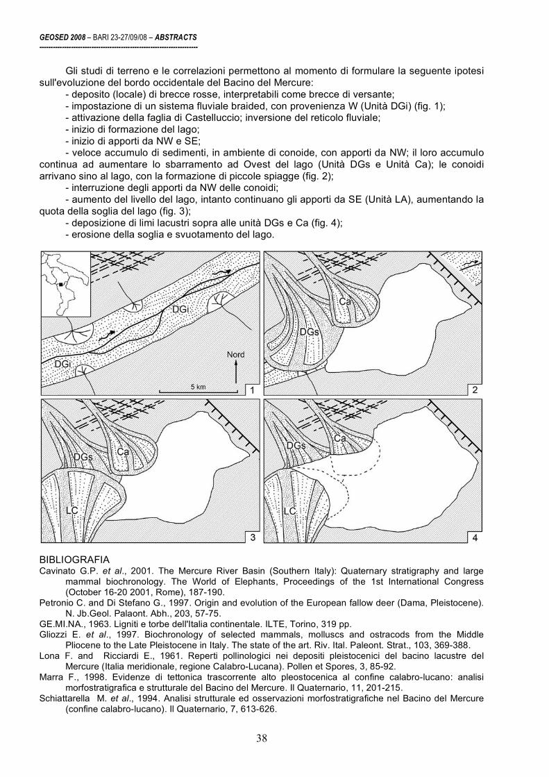
GEOSED 2008 – BARI 23-27/09/08 – ABSTRACTS ----------------------------------------------------------------------
38
Gli studi di terreno e le correlazioni permettono al momento di formulare la seguente ipotesi sull'evoluzione del bordo occidentale del Bacino del Mercure:
- deposito (locale) di brecce rosse, interpretabili come brecce di versante; - impostazione di un sistema fluviale braided, con provenienza W (Unità DGi) (fig. 1); - attivazione della faglia di Castelluccio; inversione del reticolo fluviale; - inizio di formazione del lago; - inizio di apporti da NW e SE; - veloce accumulo di sedimenti, in ambiente di conoide, con apporti da NW; il loro accumulo
continua ad aumentare lo sbarramento ad Ovest del lago (Unità DGs e Unità Ca); le conoidi arrivano sino al lago, con la formazione di piccole spiagge (fig. 2);
- interruzione degli apporti da NW delle conoidi; - aumento del livello del lago, intanto continuano gli apporti da SE (Unità LA), aumentando la
quota della soglia del lago (fig. 3); - deposizione di limi lacustri sopra alle unità DGs e Ca (fig. 4); - erosione della soglia e svuotamento del lago.
BIBLIOGRAFIA Cavinato G.P. et al., 2001. The Mercure River Basin (Southern Italy): Quaternary stratigraphy and large
mammal biochronology. The World of Elephants, Proceedings of the 1st International Congress (October 16-20 2001, Rome), 187-190.
Petronio C. and Di Stefano G., 1997. Origin and evolution of the European fallow deer (Dama, Pleistocene). N. Jb.Geol. Palaont. Abh., 203, 57-75.
GE.MI.NA., 1963. Ligniti e torbe dell'Italia continentale. ILTE, Torino, 319 pp. Gliozzi E. et al., 1997. Biochronology of selected mammals, molluscs and ostracods from the Middle
Pliocene to the Late Pleistocene in Italy. The state of the art. Riv. Ital. Paleont. Strat., 103, 369-388. Lona F. and Ricciardi E., 1961. Reperti pollinologici nei depositi pleistocenici del bacino lacustre del
Mercure (Italia meridionale, regione Calabro-Lucana). Pollen et Spores, 3, 85-92. Marra F., 1998. Evidenze di tettonica trascorrente alto pleostocenica al confine calabro-lucano: analisi
morfostratigrafica e strutturale del Bacino del Mercure. Il Quaternario, 11, 201-215. Schiattarella M. et al., 1994. Analisi strutturale ed osservazioni morfostratigrafiche nel Bacino del Mercure
(confine calabro-lucano). Il Quaternario, 7, 613-626.

GEOSED 2008 – BARI 23-27/09/08 – ABSTRACTS ----------------------------------------------------------------------
39
Pliocene paleoshorelines and uplift rates at the Tyrrhenian margin of central Apennines (Italy)
D. Cosentino
1, F. Castorina
2, P. Cipollari
1 and G. Fubelli
1
1 Università degli Studi Roma Tre, Largo San Leonardo Murialdo, 1, I-00146 Roma
2 Università degli Studi di Roma “La Sapienza”, Piazzale Aldo Moro, 5, I-00175 Roma
This paper deals with the geological and geomorphological evolution of the Pliocene
Tyrrhenian coastal plain in central Italy. New data about ancient marine terraces and abrasion platforms coming mainly from the western slope of the Lucretili and Sabini Mts are discussed.
At the Tyrrhenian side of the central Apennines, markers referable to ancient shorelines of the Tyrrhenian Sea (tidal notch, inner margin of marine terrace, Lithophaga holes band, beachrock, cliff breccia, wave-cut platform, etc.) have been signaled onshore, at different elevations (Nisi et al., 2003, with references therein; Mancini et al., 2007, with references therein). The “uppermost” paleoshoreline recognized in the Middle Tiber Valley (MTV) (northern Latium) shows sedimentary and geomorphic evidences decreasing from 480 m (to the north) to 220 m a.s.l. (to the south) (Mancini et al., 2007, with references therein). Recently, the age of the MTV “uppermost” paleoshoreline has been matter of debate. According to geomorphological, paleontological and 87Sr/86Sr isotope analyses, Mancini et al. (2007, 2008) consider this paleoshoreline as Santernian (Early Pleistocene) in age, whereas Cosentino and Fubelli (2008) taking into account geomorphological, paleontological and paleoclimate considerations suggest a Gelasian age (Late Pliocene) for the same sedimentary and geomorphic features, at least for the southern part of the MTV “uppermost” paleoshoreline.
In the study area, remnants of an ancient marine terrace, which shows its inner margin at 498 m a.s.l., have been recently recognized at the western side of the Lucretili Mts, where markers of the MTV “uppermost” paleoshoreline occur at about 250 m a.s.l. Structural and facies analyses allow us to consider these markers referable to two different paleoshorelines rather than to the same marine terrace tectonically displaced. The finding of an ancient marine terrace at 498 m a.s.l. on the western margin of the Lucretili Mts allow us to consider some flattened areas recognized at the same altitude (490 m a.s.l.) in the Southern Sabini Mts (S. Martino-Fara in Sabina) as remnants of an ancient wave-cut platform due to the same highstand episode of the Tyrrhenian Sea. In this frame, the flat area of S. Oreste village (Soratte Mt), at about 420 m a.s.l. on the western bank of the Tiber Valley, can be considered as the remnant of a coeval abrasion platform, slightly downthrown by post-orogenic tectonics, cut in the Mesozoic limestones at the base of the carbonate cliff of the Soratte Mt.
In order to define the age of the paleoshoreline at 498 m a.s.l. by using geochemical methods (87Sr/86Sr), beachrock samples and mollusk shells have been collected from the relative coastal deposits. Moreover, to compare the 87Sr/86Sr values of samples from both marine terraces, specimens of Cladocora caespitosa, Ostrea sp. and balanids have been collected nearby Marcellina village from the marine deposits related to the MTV “uppermost” paleoshoreline at 250 m a.s.l.
Reliable 87Sr/86Sr value for determining the age of the real uppermost paleoshoreline in the area has been obtained from the Ostrea sp. (0.709026 ±6) collected at 498 m a.s.l. on the western slope of the Lucretili Mts (Colle Pietro area). For the paleoshoreline at 250 m a.s.l., the collected samples in the immediate vicinity of the village of Marcellina show 87Sr/86Sr values ranging from 0.709070 ±8 and 0.709030 ±7. The obtained 87Sr/86Sr isotopic data are generally lower than the values reported in Mancini et al. (2007) for the southern part of the MTV “uppermost” paleoshoreline.
However, the error bar for each 87Sr/86Sr value can correspond to an error in the estimating age of about 0.35 - 2.5 Ma. Then, to estimate a realistic age, especially for the middle part of the Pliocene, the chronological indication from 87Sr/86Sr values must be integrated with information from other methods.

GEOSED 2008 – BARI 23-27/09/08 – ABSTRACTS ----------------------------------------------------------------------
40
Fig. 1 – Comparison of 87Sr/86Sr values for samples from Lucretili Mts (SP and MC) with results from Punta Piccola, Sicily (McArthur et al., 2006); Sites 519, 588, 607 (Hodell et al., 1991); Site 722 Beets (1991); Site 590 (Richter and De Paolo, 1988; Capo and DePaolo, 1990) and Site 758 (Farrell et al., 1995).
In this case, the occurrence of Globorotalia inflata in the open marine deposits relatable to the MTV “uppermost” paleoshoreline and the estimated age for the upper bathyal deposits of the Marne Vaticane Auct. (MPl 4a, topmost Zanclean) (Cosentino et al., in press), which crop out at Vaticano Mt and Farnesina Mts (Rome), have been used to better constrain the age of these paleoshorelines (Fig. 1).
Taking into account Farrell et al. (1995) and McArthur et al. (2006), and considering the regional stratigraphic framework of the Pliocene-Pleistocene deposits at the Tyrrhenian margin of central Apennines (Barberi et al., 1994) and in the city of Rome (Cosentino et al., in press) as well, the obtained 87Sr/86Sr values can be referred to the seawater of the uppermost part of the Early Pliocene and the Middle-Late Pliocene sedimentary cycles, which show their paleoshoreline at 498 m (topmost Zanclean) and 250 m a.s.l. (Gelasian), respectively (Fig. 1).
These chronological data allow us to compute for the central Apennines a quasi-constant post-orogenic long-term-uplift-rate during the Pliocene-Early Pleistocene, with post Zanclean and post Gelasian vertical movement of 0.128 and 0.119 mm/a, respectively. REFERENCES Barberi F. et al., 1994. Plio-Pleistocene geological evolution of the geothermal area of Tuscany and Latium.
Memorie Descrittive della Carta Geologica d’Italia, 49, 77-134. Beets C.J., 1991. The late Neogene 87Sr/86Sr isotopic record in the western Arabian Sea, Site 722. In Proc.
ODP Sci. Res., 117, 459-464. Capo R.C. and De Paolo J.D., 1990. Seawater strontium isotopic variations from 2.5 million years ago to the
present. Science, 249, 51-55. Cosentino D. et al., (in press). Geologia dei Monti della Farnesina (Roma): nuovi dati di sottosuolo dalla
galleria Giovanni XXIII. Memorie Descrittive della Carta Geologica d’Italia, in press. Cosentino D. and Fubelli G., 2008. Comment on: “Geomorphological, paleontological and 87Sr/86Sr isotope
analyses of early Pleistocene paleoshorelines to define the uplift of central Apennines (Italy)”. Quaternary Research, 69, 163-164.
Farrell et al., 1995. Improved chronostratigraphic reference curve of late Neogene seawater 87Sr/86Sr. Geology, 23(5), 403-406.
GEOSED 2008 – BARI 23-27/09/08 – ABSTRACTS ----------------------------------------------------------------------
41
Hodell D.A. et al., 1991. Variations in the strontium isotopic composition of seawater during the Neogene. Geology, 19, 24-27.
Mancini M. et al., 2007. Geomorphological, paleontological and 87Sr/86Sr isotope analyses of early Pleistocene paleoshorelines to define the uplift of central Apennines (Italy). Quaternary Research, 67, 487-501.
Mancini M. et al., 2008. Invited replay to the Comment on: “Geomorphological, paleontological and 87Sr/86Sr isotope analyses of early Pleistocene paleoshorelines to define the uplift of central Apennines (Italy)”.Quaternary Research, 69, 165-167.
McArthur J.M. et al., 2006. A revised Pliocene record for marine 87Sr/86Sr used to date an interglacial event recorded in the Cockburn Island Formation, Antarctic Peninsula. Paleogeography, Palaeoclimatology, Palaeoecology, 242, 126-136.
Nisi et al., 2003. Coastal deformation between the Versilia and the Garigliano plains (Italy) since the last interglacial stage. Journal of Quaternary Science, 18, 709–72.
Richter F.M. and DePaolo D.J., 1988. Diagenesis and Sr isotopic evolution of seawater using data from DSDP 590B and 575. Earth and Planetary Science Letters, 90, 382-394.

GEOSED 2008 – BARI 23-27/09/08 – ABSTRACTS ----------------------------------------------------------------------
42
Rhodoliths and Acervulinid macroids: useful tools to evaluate water energy in ramp settings
A. d'Atri 1,2 and D. Varrone 2,1
1 Università degli Studi di Torino, Dipartimento di Scienze della Terra, Via Valperga Caluso 35, 10125 Torino
2 CNR-IGG, Consiglio Nazionale delle Ricerche - Istituto di Geoscienze e Georisorse, Via Valperga Caluso 35, 10125 Torino
Carbonate and mixed siliciclastic-carbonate ramp sediments rich in rhodoliths and macroids
have been studied. Material coming from Bartonian Nummulitic Limestone (southernmost Alpine foreland basin), Rupelian Molare Formation and Burdigalian Visone Formation (Piemonte Tertiary Basin) has been analysed on polished hand-samples and thin sections.
Studies on taxa abundance have evidenced that calcareous red algae and acervulinid are the main builders of the “macroids l.s.”. Founding on taxa abundance four main types of “macroids l.s.” have been recognized (table 1): monospecific macroids, 2) multitaxonomic macroids, 3) multispecific rhodoliths and 4) multitaxonomic rhodoliths.
Tab. 1 Main features of the recognized “macroids l.s.” (terms of growth forms are according to Bosence 1983).

GEOSED 2008 – BARI 23-27/09/08 – ABSTRACTS ----------------------------------------------------------------------
43
1) Monospecific macroids consist of a dominant acervulinid community (>95%) represented by Solenomeris and are characterized by the absence of a clastic nucleus. Growth structures are irregularly spheroidal, columnar to laminar boxwork, and the cavities are filled by sediment. Monospecific macroids, characterized by distinct protuberances, grow predominantly in low-energy environment. In fact, according to Rasser (1994), distinct growth directions of the columnar macroid point to a low frequency of overturning due to a low-energy environment or to the occurrence of traps as seagrass. This type of macroid occurs in floatstones with a microbioclastic matrix and according to Nalin et al. (2007) can be related to a lower energy setting in confront to 2, 3 and 4 types.
2) Multitaxonomic macroids consist of acervulinid Solenomeris (about 80%), encrusting
foraminifera (Victoriella, Silvestriella, Haddonia), calcareous red algae, anellids and bryozoa. Usually the nucleus is small to absent, the growth structures are mainly spheroidal, laminar concentric and rarely columnar. This type of macroids occurs in rudstone with a mixed siliciclastic-carbonate matrix and indicates shallow high-energy settings.
3) Multispecific rhodoliths (>90% calcareous red algae) are characterized by high
nucleus/algal cover ratio, with an irregularly spheroidal growth structure. The internal arrangement of the algal laminae predominantly results in a laminar concentric very dense framework. The original morphology of the nucleus strongly influences the final aspect of the rhodolith. This type of rhodolith occurs in rudstone or clast-supported conglomerate and is interpreted as the product of relatively high-energy setting (Nalin et al. 2007).
4) Multitaxonomic rhodoliths are spheroidal laminar concentric and consist of a coating
sequence of calcareous red algae (40-50%), encrusting foraminifera and bryozoa with high nucleus/algal cover ratio. They occur in rudstone with scarce mixed siliciclastic-carbonate matrix. The momentary replacement of calcareous red algae with other taxa indicates a temporary change of environmental conditions (i.e. decrease in light intensity for increasing of terrigenous input and water turbidity). This type of rhodoliths indicates higher energy setting.
The dominance of rhodoliths or acervulinid macroids is mainly due to light intensity,
connected to water turbidity and/or changes in terrigenous input. REFERENCES Bosence D. W. 1983. Description and classification of rhodoliths (Rhodoids, Rhodolites). In: Coated Grains
(Ed. by T. M. Peryt), 217-224. Springer-Verlag, Berlin Heidelberg. Nalin et al. 2007. Rhodolith-bearing limestones as transgressive marker beds: fossil and modern examples
from North Island, New Zealand. Sedimentology, 55, 249-274. Rasser 1994. Facies and palaeoecology of rhodoliths and acervulinid macroids in the Eocene of the
Krappfeld (Austria). Beitr. Paläont. 19, 191-217. Varrone D. & d'Atri A. 2007. Acervulinid macroid and rhodolith facies in the Eocene Nummulitic Limestone of
the Dauphinois Domain (Maritime Alps, Liguria, Italy). Swiss j. Geosci., 100, 503-515.

GEOSED 2008 – BARI 23-27/09/08 – ABSTRACTS ----------------------------------------------------------------------
44
The Chattian-Messinian Salento super-sequence and its relation with tectonic and paleoclimate
M. Delle Rose
Consiglio Nazionale delle Ricerche, IRPI, via G. Amendola 122/i, Bari, [email protected]
The Salento peninsula, a sub-domain belonging to the Apulia Platform (Auct.), houses
continental, transitional and marine Oligocene to Miocene deposits. These terrains are arranged into a number of informal units frequently object of re-definitions, whereas only very few lithostratigraphic units were validated even if actually overstaying some questions, such as the stratigraphic relation between Andrano Calcarenite and Novaglie formation or the age of the Galatone Formation anyhow encompassing a poorly biostratigraphical defined time span between Oligocene and Miocene. As a consequence, the stratigraphic setting is interpreted in several ways that, among others things, arise the problem about the choice of the cartographic tools for the redaction of derivate maps, such as the hydrogeological hazards.
This research deals with the drawing of the stratigraphic architecture of the Salento Oligocene to Miocene deposits (fig. 1), that as a whole has reference to a second order stratigraphy sequence. The tools of the research have been stratigraphic and sedimentological analyses as well as the mapping of lithozone and uncoformity surfaces.
Fig. 1 – Stratigraphic Scheme. 1. Lower-Middle Pleistocene; 2. Middle Pliocene – Lower Pleistocene; 2.1. Lower Pliocene; 3. Chattian-Messinian supersequence; 4. continental and transitional deposits; 5. residual deposits; 6. Cretaceous and locally Eocene.

GEOSED 2008 – BARI 23-27/09/08 – ABSTRACTS ----------------------------------------------------------------------
45
Oligocene-Miocene lie on a Cretaceous and locally Eocene substratum capped by residual
deposits, dissected into horst and graben systems and intensively shaped by sub-aerial conditions during large part of the Paleogene. Marly limestones buried beneath Lecce urban area have pioneeristic referred to the Oligocene in spite of the lack of adequate studies (Palmentola, 1978). Later, probably homologous deposits, exhumed by road building excavation, were referred to Oligo-Miocene oscillating continental to marine transition (Esu et al., 1995). Very few are the knowledge about the sedimentological arrangement of this kind of sedimentary bodies.
The bottom unit of the super-sequence is the Castro limestone, a reef complex built mainly by corals, that largely cropping out along the south eastern cliff of the Salento peninsula (Bosellini, 2006). It underlies the P. Badisco calcarenite through a paraconformity surface whit erosive features on which lies a discontinuous rhodolitic level. Especially the upper portion of the P. Badisco calcarenite, rich in Miogypsina sp. and well exposed along the Canaloni di Badisco, needs detailed stratigraphic and sedimentological reviews. In any case an upward regressive trend was not recognized and a correlation with the bottom stratigraphic level of the pietra leccese must be checked. The overlying high rich in phosphatized grains Aturia level is in paraconcordance without erosional shapes, letting to hypothesize a gap in the geological record without emersion.
The Aturia level, a condensed phosphatized residual lag deposited on a hardground surface, is paraconformably covered by a broad glauconitic grains rich marker bed along the south east Salento coast (Delle Rose, 2001) traditionally named Piromafo. South of Otranto the following condensed succession has reconstructed: Cretaceous substratum, bauxitic terrain, transitional to marine Oligocene and probably earliest Miocene deposits (Esu et al., 2005), Aturia and Piromafo levels, reduced Messinian (Ungaro, 1966) lumachella beds.
Marine Aquitanian deposits had been recognized for the first time by Luperto Sinni (cit. in D’Alessandro and Palmentola, 1978) at Copertino; a late Oligocene-early Miocene unit (here labelled as lithozone) named “Scutelle limestones” was successively described between Nardò and Galatone (Barbera et al., 1993).
Oligoaline deposits crop out east of Lecce contain abundant Metacypres gr. Danubialis, attribute to the Chattian (Conato, cit. in Del Prete and Santagati, 1972) and specimens of the striate ostracods and Darwinula aff. cylindrica, both referred to the Tortonian inside the Danube Basin (Auct.). Really the striate ostracods have very restricted biostratigraphic power whereas the chronostratigraphic span of D. cylindrica encompass a Lower Miocene-Pleistocene interval, although some Oligocene forms are again referred to such species. Samples of marls and limestones extracted by the Lecce subsoil are referred to the Galatone Formation (Bossio et al., 2006) by means of gastropods internal mould considered belong to Ampullinopsis crassantina that has undetected inside the aforementioned oligoaline deposits. Actually, the stratigraphic relationship between the NE Salento Oligocene and Miocene units are uncertain (fig. 1).
Even is extensively cropping out, the boundary between pietra leccese and Andrano Calcarenite is differently interpreted either as stratigraphically continuous with or without interval of transition; heteropic, transgressive and disconformable. According to the Geological Map of Italy at 1:100.000 scale, the Miocene deposit on which Lecce had erect entirely belonging to the pietra leccese, whereas according to Bossio et al. (2006) they must be partially referred to the Andrano Calcarenite. The age corroborate by the Geological Map of Italy spanning from the Burdigalian p.p. (formerly called Elvetian) to the late Miocene (Messinian p.p.), had recently been detailed (Bossio et al., 2006). Significant thickness of pietra leccese aren’t exposed whereas inside stone quarries only the middle or upper levels of the unit can be observed. The pietra leccese must be considered as both traditional and subsurface unit aiming to establish unambiguous definition in observance of the stratigraphic codes, checking excavations and boreholes to define really operable stratotype.
The pietra leccese is overlaid by the Piromafo, in turn locally fades into a “glauconitic pietra leccese”, that have to distinctly mapped in the perspective of a modern cartography. Moreover the passage from pietra leccese to glauconitic deposits can be related with the astronomical driven transition from the Miocene Climate Optimum to the subsequent global cooling. Also the Andrano Calcarenite record some climate events as well probably Messinian tectonic displacements; around the main horst, this formation in overlies by a chaotic assemblage, unformally know as breccia di Leuca, consists of megablocks, breccias and pebbles within heterogeneous matrix that must be separately mapped.

GEOSED 2008 – BARI 23-27/09/08 – ABSTRACTS ----------------------------------------------------------------------
46
Finally, it seems significant to carry out that the Chattian-Messinian Salento present analogies with the coeval super-sequence of the Maiella formed inside an opposite ramp of the Apulia Platform. REFERENCES Barbera C. et al., 1993. Il giacimento a scutelle di cava I Rizzi. Guida alle Escursioni XII Conv. Soc. Paleont.
It., 91-96. Bosellini F., 2006. Biothic changes and their control on Oligocene-Miocene reefes: A case study from the
Apulia Platform Margin. Palaeogeography, Palaeoclimatology, Palaeoecology, 241, 393-409. Bossio A. et al., 2006. Stratigrafia neogenica-quaternaria del settore nord-orientale della provincia di Lecce.
Geol. Rom., 39, 63-87. D’Alessandro A. and Palmentola G., 1978. Sabbie a brachiopodi, una nuova unità del Salento leccese. Riv.
It. Paleont., 84, 1083-1120. Delle Rose M., 2001. Salento Miocene: a preliminary paleoenvironmental reconstruction. Thalassia
Salentina, 25, 41-66. Del Prete M. and Santagati G., 1972. Depositi oligoalini interposti tra calcari cretacici e pietra leccese. Geol.
Appl. Idrogeol., 7, 225-233. Esu D. et al., 1995. Lagoonal-continental Oligocene of southern Apulia. Boll. Soc. Paleont. It., 33, 183-195. Esu D. et al., 2005. Late Oligocene-?Miocene mollusc and foraminiferal assemblages from the vicinity of
Otranto. Rend. Soc. Paleont. It., 2, 75-85. Palmentola G., 1978. Lineamenti geologici e morfologici del Salento leccese. Atti Conv. Geol. Salento, 7-23. Ungaro S., 1966. Prima segnalazione del Miocene superiore nella penisola salentina. Mem. Museo Civ. St.
Nat., 14, 435-448.

GEOSED 2008 – BARI 23-27/09/08 – ABSTRACTS ----------------------------------------------------------------------
47
Eustatic-climate versus tectonic control of Pliocene-lower Pleistocene sequence stratigraphic surfaces (Salento, south Italy)
M. Delle Rose
Consiglio Nazionale delle Ricerche, IRPI, via G. Amendola 122/i, Bari, [email protected]
The stratigraphic arrangement of two Pliocene-Lower Pleistocene Salento sequences have
been reconstructed by means of stratigraphic and sedimentological analyses as well as the mapping of a number of lithozones (i. e. lithological facies, unformal units) and some uncoformities. The sequences show intriguing climate proxy records as well some sedimentological response to geodynamic phases and events.
A chaotic assemblage lies above the basal disconformity surface. It consists of megablocks, breccias and pebbles in heterogeneous matrix containing lens of clay and limestone, probably formed inside transitional environments subject to intense evaporation under warm and dry climate, and oolithic calcarenites with Strombus coronatus (Massari and D’Alessandro, 2000). The chaotic assemblage fades into marlstones, related to the Trubi Fm (Bossio et al., 1991), and is draped by condensed glauconitic siltstones (Zanclean-Piacenzian). These lithozones respectively represent the sedimentation of clasts dismantled during the Messinian Salinity Crisis and later settled in transitional environment, the Pliocene inundation (Iaccarino et al., 1999) and the subsequent very low rate of sedimentation period (Cita et al., 1999) during the maximum Mediterranean flood.
They are separated by a paraconformity from a phosphatized rudite which represents a regional marker and whose gravitational deposition can be related to the about 2.5 My cooling onset and/or the southern Apennines Middle-Upper Pliocene tectonic phase. The previous phosphatization process of the clasts probably occurred at inner-middle shelf (Delle Rose, 2006) during the most recent extended period significantly warmer than today.
The aforementioned lithozone have been recognized at the south-eastern portion of the investigated region, whereas at the opposite Triglio hydrographic basin where Salento fades into le Murge plateau, a supposed Upper Pliocene marly unit (nearly unknown in literature) is interposed between Cretaceous and calcarenites and calcilutites (Delle Rose, 2007).
The calcarenites and calcilutites (Gelasian-Santernian) consist of fossiliferous intensively bioturbated coarse to fine-grained beds, supplied from an expansive source area located to the north west of Salento as far as the Murge. This facies (the High Stand Tract relative to the sea level dropping) includes the Uggiano La Chiesa formation (Auct.) and can be related to the Gravina Calcarenite Fm. It presents depositional features mainly driven by the accommodation space. Along the east Salento, it is interbedded with greenish-brown clayey lutites that represent astronomical forcing sapropelic deposits. At the top, the calcarenites and calcilutites contain Arctica islandica, somewhere inside biogenic shell concentrations (Delle Rose and Medagli, 2007).
With relation to the third order sequence cycles (Haq et al., 1987; Berggren et al., 1995), the first three lithozones can be related to TB 3.4, TB 3.5 and TB 3.6, the phosphatized rudite to TB 3.7 and the calcarenites and calcilutites to TB 3.8.
Along the central and western Salento, the calcarenites and calcilutites are overlain by a glauconitic sandy deposit rich in mollusc and brachiopods, especially Terebratula scillae, by means of a disconformity surface. The “brachiopods sands”( D’Alessandro and Palmentola, 1978; Delle Rose and Medagli, 2007) zone form the base deposit of the upper sequence, about which an Emilian-Sicilian age could tentatively assigned. In any case the highest sandy beds have been referred to the Pseudoemiliana Lacunosa zone (Coppa et al., 2001; D’Alessandro et al., 2004).
The age of formation of the disconformity between calcarenites and calcilutites and “brachiopods sands” falls into a period characterized both of eustatic-climate sea level drop and tectonic deformation of the southern Apennine and the Apulian Foreland. In any case, this phase set a drastic change of the sediments transportation and accumulation inside the shelf, stopping or reducing the sandy supplying of the east Salento and bordering the subsequent clayey sedimentation within the central and west sectors.
Where complete successions are found, as an example in the Cutrofiano area (fig. 1), the aforementioned greenish sandy deposits fades into marly-clay beds that represent the local Argille

GEOSED 2008 – BARI 23-27/09/08 – ABSTRACTS ----------------------------------------------------------------------
48
azzurre (Auct.). The latter, more and more sandy toward the top containing at least one trachyte volcanogenic decimetric bed (Delle Rose et al., 2007), are in turn locally overlie by sands probably homologous of the Monte Marano Sands Fm of the Bradanic trough cycle (Auct.). The whole Emilian-Sicilian (or early Ionian) sequence is related to the TB 3.9 third orders cycle; the origin of its upper boundary surface appear related to the begin of the “glacial Pleistocene”.
Fig. 1 – Stratigraphic sections. A, Emilian-Sicilian sequence; B, B1, Zanclean-Santernian sequence; C, D, pre-Pliocene; 1 ,4, 7 and 13 partially reconstructed using boreholes data; 2, 6, 9, 10, 11, 12, present paper; 3, Massari and D’Alessandro, 2000; 4, upper part: Cherubini and Margiotta, 1984; 5, D’Alessandro and Palmentola, 1978; 7, biostratigraphy from Bossio et al., 1987; 8, D’Alessandro et al. (2004); 12, Casamassella section from Bossio et al., 1991; 13, Bossio et al., 1985. REFERENCES Berggren W.A. et al., 1995. Late Neogene chronology: New perspectives in high-resolution stratigraphy.
Geol. Soc. Am. Bull., 107, 1272-1287. Bossio A. et al., 1985. La sequenza pliocenica di S. Andrea (Lecce) e il suo contenuto in pesci, ostracodi,
foraminiferi e nannofossili. Mem. Soc. Toscana Sc. Nat., 92, 35-93. Bossio A. et al., 1987. Stratigrafia del pozzo Poggiardo. Atti Conv. Geol. Salento, 55-87. Bossio A. et al., 1991. Note geologiche e stratigrafiche sull’area di Palmariggi. Riv. It. Paleont. Strat., 97,
175-234. Cita B.M. et al., 1999. Changes in sedimentation rates in all Mediterranenan drillsites document basin

GEOSED 2008 – BARI 23-27/09/08 – ABSTRACTS ----------------------------------------------------------------------
49
evolution and support starved basin condition after early Zanclean flood. Mem. Soc. Geol. It., 54, 145-159.
Cherubini C. and Margiotta B., 1984. Caratteristiche geolitologiche e geotecniche dei depositi quaternari di Nardò. Quad. Centro Studi Geotecnici Ingegneria, 9, 3-19.
Coppa M.G. et al, 2001. The Pleistocene with Aequipecten opercularis of Campo di Mare. Boll. Soc. Paleont. It., 40, 405-429.
D’Alessandro A. and Palmentola G., 1978. Sabbie a brachiopodi, una nuova unità del Salento leccese. Riv. It. Paleont., 84, 1083-1120.
D’Alessandro A. et al., 2004. Pliocene-Peistocene bounded by subaerial unconformities within foramol ramp calcarenites and mixed deposits. Sedimentary Geology, 166, 89-144.
Delle Rose M., 2006. Mediterranean Pliocene events in the Salento geological record. Thalassia Salentina, 29, 77-99.
Delle Rose M., 2007. Sedimentological features of the Plio-Quaternary aquifers of Salento. Mem. Descr. Carta Geol. D’It., 76, 137-146.
Delle Rose M. and Medagli P., 2007. The Lower Pleistocene succession of Contrada Torsano. Thalassia Salentina, 30, 57-79.
Delle Rose et al., 2007. Volcanogenic sediments of the Apulian Foreland: implications on paleoenvironment and provenance. VI Forum It. Sc. Terra, Epitome, II, 147.
Haq B.U. et al., 1987. Chronology of fluctuating sea levels since the Triassic. Science, 235, 1156-1167. Iaccarino S. et al., 1999. The Miocene-Pliocene boundary and the significance of the earliest Pliocene
flooding in the Mediterranean. Mem. Soc. Geol. It., 54, 109-131. Massari F. and D’Alessandro A., 2000. Tsunami-related scour-and-drape undulations in Middle Pliocene
restricted carbonate deposits (Salento). Sedimentary Geology, 135, 265-281.
GEOSED 2008 – BARI 23-27/09/08 – ABSTRACTS ----------------------------------------------------------------------
50
Architecture and depositional evolution of a Permian slope channel-levee system: Unit D of the Laingsburg Formation, Karoo basin, South Africa
C. Di Celma, R. Brunt, D. Hodgson, J. Kavanagh and S. Flint
Stratigraphy Group, Department of Earth and Ocean Sciences, University of Liverpool,
Liverpool, L69 3GP, UK
High-resolution seafloor and subsurface imaging have provided high-resolution views of the submerged continental margins, furthering our understanding of the evolutionary stages of submarine valleys. At finer scales, however, their sedimentary fills exhibit a high level of architectural complexity that remains difficult to be assessed in detail with conventional seismic data but are crucial to constrain reservoir behaviour and properties. Outcrop analogues span a critical gap in both scale and resolution between seismic and well-bore data and may help to improve characterisation of these architectural details. Nevertheless, multiple sections through the same stratigraphic unit are rare and the down-dip changes in architectural style are difficult to assess. An example of an ancient submarine valley that can be documented in multiple cross-sections over 30 km down depositional dip is Unit D of the Permian Laingsburg Formation. The exceptional, laterally continuous outcrop belt along which this unit is exposed provides a nearly unique opportunity to describe in detail the down-slope architectural changes from an entrenched to a mostly constructional channel-levee system at a similar scale to many modern slope systems. Five main architectural elements can be recognised: (i) the erosional fairway; (ii) wedge-shaped external levees; (iii) channel-axis deposits flanked by (iv) internal levees; (v) mass flow deposits. In proximal sections, the 120 m-deep erosional fairway provides confinement for the fill with asymmetric external levees indicating the conduit was underfilled when abandoned and significant sinuosity. The axial fill has a bipartite architecture comprising an early-stage set of laterally migrating channel complexes, and late-stage aggradational channels flanked by internal levees. Twenty kilometers downslope of this section, the amount of basal incision decreases progressively whereas the thickness of the external levees increases. As a result, the nature of the system becomes more constructive and levee confined, and evidence of channel avulsion more common

GEOSED 2008 – BARI 23-27/09/08 – ABSTRACTS ----------------------------------------------------------------------
51
Karstic archaeostratigraphic record in Central Portugal: characterizing and interpreting sedimentary unconformities
L. A. Dimuccio1 and T. Aubry2
1 Geographic Institute and Department of Earth Sciences, Coimbra University, 3000 Coimbra, Portugal
2 IGESPAR-IP, Rua da Fontinha, nº62, Fala, 3045-398, Coimbra, Portugal
The goal of this study is to examine and present new archaeostratigraphical data, focusing on erosive unconformities (disconformity), through a geoarchaeological approach of one open-air settlement (Gândara Outil - Outil/Cantanhede Carbonate Plateau), two caves (Buraca Grande and Buraca Escura – Sicó Carbonate Massif) and three rock shelters (Abrigo Vale Covões and Vale Buracas – Sicó Carbonate Massif) and the Lagar Velho (Lapedo Valley - Leiria). Excavations integrated in a research project begun in 1991, revealed Middle and Upper Palaeolithic sequence of human occupation in these sites localized in central Portugal (Fig. 1).
Fig. 1 – Geological map of the central Portugal (modified from Wilson et al., 1989) and location of geoarchaeological sites under investigation.

GEOSED 2008 – BARI 23-27/09/08 – ABSTRACTS ----------------------------------------------------------------------
52
Fieldwork at the sites included a systematic description of the exposed cross-sections and
profiles to reconstruct the stratigraphic sequence, its vertical and lateral variations and the human-related inputs and features. Informal Gearchaeological Field Units (GFU#), identified on the basis of lithostratigraphic, pedological e/or archaeological criteria, were used as field entities. The field units were later grouped into Gearchaeological Complexes (GC#), grounded on the criteria of stratigraphic correlation and use as a framework for the interpretation of the archaeostratigraphic record. To complete the relative chronology established by the stratigraphic sequence, selected samples of charcoal and bones, conserved in the GFU, were dated by 14C Conventional (Con.) and Accelerator Mass Spectrometry (AMS) methods. The chronology of human occupation phases predating 40.000 BP was established by Uranium-series dates (U/Th) obtained on horse teeth samples.
Several erosive unconformities, hiatus and soil stabilization phases were detected in the
sequences containing remains extending from the Middle Palaeolithic to the end of the Upper Palaeolithic. A main disconformity event detected on between the different sequences, spread on about 60 kilometres of the Meso-cenozoic Lusitanian Basin of the Iberian Peninsula (Western Portugal), could be correlated with the Heinrich Event 3 (H3), dated by 14C between 28.500 and 27.000 BP.
This main erosional event could be explained by a global environmental change and a
lowering of the sea base level, toward colder and moister condition and dated ante post quem of ca 27.000 BP by the absolute dating of remains recovered in the stratigraphic units filling its disconformities in the archaeostratigraphical sequence studied. The implication of this main erosional event was a clear reorganization of the karstic base level and the correlative erosion of sediments and soils accumulated in cave, rock shelters and open air sites, deposited after the Heinrich Event 4 (35.000-39.000 BP), containing the latest Middle Palaeolithic and eventually the first Upper Palaeolithic occupations.
In this situation, the preservation of Early Upper Palaeolithic remains in a well preserved and
primary deposition context is highly improbable in normal condition of karst sedimentation and, in the absence of a rapid and high sedimentation rate, archaeological remains of this chronological interval were redeposited and integrated in subsequent geoarchaeological complexes. This hypothesis is in agreement with the fact that human occupations of the Early Upper Palaeolithic in Portugal have still only been detected on the argument of few typical lithic and bones tools points categories known in other geographical setting and from isolated AMS dates obtained on organic materials.
The systematization of the geoarchaeological approach, the systematic survey orientated for
the detection of others open-air and karstic geomorphological situations (aeolian deposition, increase of sedimentation induced by a tectonic process, etc.) is necessary and could help us to overcome current shortcomings on the record of human occupation for this period of transition between Neandertal and Modern humans in Southern Iberia.

GEOSED 2008 – BARI 23-27/09/08 – ABSTRACTS ----------------------------------------------------------------------
53
Geochemical analysis of the upper shoreface sediments between Livorno and the Serchio River (Tuscany): a focus on heavy metals
E. Dinelli1, V. Laterza2 and G. Sarti2
1 Dipartimento di Scienze della Terra e Geologico-Ambientali, Università di Bologna – Piazza di Porta San Donato, 1 – 40126 Bologna
2 Dipartimento di Scienze della Terra, Università di Pisa – Via Santa Maria, 53 – 56126 Pisa
This study, conducted in collaboration with the Geological office of Province of Pisa, was carried out in order to assess the spatial distribution of some heavy metals of environmental relevance (Cr, Ni, Pb, Zn, Cu) in near-surface (10-20 cm deep) coastal marine sediments (upper shoreface), collected along the coastline of the province of Pisa, between the Serchio River and Livorno (northern part of Tuscany, Italy).
The research enabled the evaluation of the quality status of the near-surface sediments, allowing the identification of the various sources of heavy metal on the marine basin.
The samples were collected along the upper shoreface at 1 m of water depth over 25 km of coast. To evaluate the possible variation of distribution of the heavy metal with the water depth, the sampling was extended also to six transects normal to the shore up to -10m. Moreover, sediments from the rivers (Serchio, Arno and Scolmatore canal) feeding the studied area were sampled and analyzed. Finally, samples from analogous depositional environment dating back to the Holocene and obtained through continuous cores were included in the study as representative of the natural background values.
The geochemical analyses provided for all samples an evaluation of the total concentration of Cr, Ni, Pb, Zn, Cu by X ray fluorescence spectrometry, that offered information also on other chemical elements (SiO2, TiO2, Al2O3, Fe2O3(tot), MgO, MnO, CaO, Na2O, K2O, P2O5, Sc, V, Rb, Sr, Y, Zr, Nb, Ba, La, Ce, Th). On some samples (marine, fluvial and borehole), an acqua regia digestion coupled to ICP-AES analysis has been performed. This analytical method allows the direct comparison to the thresholds quality imposed by the legislation currently in force (DM 367/2003).
The results suggest that for all the heavy metals (except Cr) a grain-size control is relevant with the highest concentrations in the samples with more abundant fine fraction. Cr appears at particularly high values (51-484 ppm Cr) in the section between the mouths of the rivers Arno and Serchio due to the selective deposition of heavy minerals. Zinc concentrations are not unusual within sandy sediments (24-56 ppm Zn), with the highest values observed near Tirrenia and up to the mouth of the Scolmatore canal. Marine sediments do not evidence particularly high values for Ni (23-58 ppm), Pb (11-28 ppm) and Cu (5-15 ppm) with a limited dispersion of the data. On the contrary, all the examined metals display high concentrations in the fine-grained fraction of river sediments. However, they are transported and accumulated offshore beyond the isobath of 10m, not compromising the quality of the analyzed coastal sediments, which are on average composed of fine or very fine sands.
Core sediments were used to calculate reference values used in the calculation of the Enrichment Factor (EF=[Me/Al]sample/[Me/Al]reference). The element with more frequent high values (EF> 1.4) is Cr: they occur from the estuary of the Serchio up to Tirrenia and partly at the mouth of Scolmatore, and are believed to be mainly originated by natural processes, such as current dynamics. This leads to an enrichment in Cr-rich heavy metals, that analogously to Ni is contained in ultramafic rocks (ophiolites) outcropping along the drainage basins especially of the Arno River. High EF for Zn occur at the mouth of the Scolmatore and the village of Tirrenia and could be related to anthropogenic sources.
Furthermore, although data of pseudototal concentrations (ICP-AES analysis) show that Cr total and Ni exceed the quality threshold (respectively of 50ppm and 30ppm) in samples from the beach and from the rivers, the same high value observed in the background samples deriving by continuous cores (average of pseudototal concentrations of Cr is 67ppm and of Ni is 48ppm) suggest the existence of high natural background concentrations for Cr and Ni in the examined area.

GEOSED 2008 – BARI 23-27/09/08 – ABSTRACTS ----------------------------------------------------------------------
54
Ambienti sedimentari della Formazione di Stilo - Capo d'Orlando (Miocene inf.) in Calabria
R. Dominici and M. Sonnino
Università degli Studi della Calabria, Dip. Scienze della Terra, 87036 Arcavacata di Rende (CS)
La Formazione di Stilo - Capo d'Orlando (FmSCO) è una delle più estese formazioni
sedimentarie dell'Italia meridionale; in Calabria affiora quasi in continuità per circa 150 km, da Stilo sino al Reggino, in una fascia parallela alla costa ionica, che prosegue in Sicilia nei Monti Peloritani in una larga area che si estende da Taormina a Capo d'Orlando.
Fin dalla sua definizione (Bonardi et al., 1980) è stata evidenziata la sua notevole variabilità verticale, laterale e di potenza, senza tuttavia mai darne una logica interpretazione. Negli anni la FmSCO è stata studiata, dal punto di vista ambientale, quasi esclusivamente in Calabria, ed è stata normalmente riferita a depositi torbiditici, più o meno ben definiti, o raramente anche a depositi di transizione, dimenticando però spesso Walther (1894); solo con Sonnino (1997) si ha una prima correlazione della FmSCO in Calabria, e viene sottolineato il fatto che la FmSCO è costituita da una membro inferiore continentale ed uno superiore marino.
La variabilità laterale e verticale della FmSCO in Calabria è evidente in alcuni esempi (da Nord verso Sud):
- nelle fiumare Assi e Stilaro: ampie conoidi alluvionali; in alcune zone si sviluppano sistemi fluvio-torrentizi, con episodi palustri (carboni); la successione schiettamente continentale evolve a piattaforma, attraverso sistemi costieri molto variabili;
- tra le fiumare Stilaro e Precariti la FmSCO si appoggia con depositi di spiaggia sulla Formazione di Pignolo (Bonardi et al., 2002, 2003), notevolmente carsificata;
- a Prisdarello, Monte Linare e Gioiosa Jonica: la FmSCO si appoggia su brecce rosse, molto alterate; nella successione si intercalano dei calcari; quindi depositi fluviali, deltizi e una successione, poco potente, di piattaforma;
- tra Agnana Calabra e Canolo: depositi continentali (conoide, fluviale, palustre); spiagge; localmente solo due metri di transizione tra il basamento e i depositi schiettamente marini; è evidente la paleogeografia;
- nell'area di Passo della Zita e Scorciapelle: sopra a depositi pre-FmSCO (brecce continentali rosse, depositi torrentizi e fluviali sino a marini) si hanno depositi fluviali con istantaneo passaggio a depositi marini;
- tra San Luca e Pietra Cappa: potenti conoidi alluvionali e sistemi braided; passaggio a sistema deltizio;
- a Bova, Pentidattilo e Montebello Jonico: potenti conoidi alluvionali, passaggio istantaneo a depositi marini.
Una serie di peculiarità caratterizzano quindi la FmSCO in Calabria: 1. Tra il basamento cristallino (e la sua copertura preorogena) e la FmSCO sono talora
presenti delle unità, nettamente separate da superfici di discontinuità stratigrafica dalla FmSCO. Ad es.: Formazione di Palizzi (Boullin et al., 1985); Formazione di Pignolo (Bonardi et al., 2002, 2003); successione di Scorciapelle (da brecce rosse a fluviale a calcari a foraminiferi); conglomerato rosso di Malevindi (presso Canolo) e del Monte Linare (Gioisa Jonica); brecce rosse di Agnana. Tutte queste unità, che precedentemente erano incluse nella FmSCO, sono continentali e solo mostra le maggiori variazioni di potenza, da pochi metri a più di 500 metri. Anche in Sicilia la FmSCO si appoggia, in modo concordante, su depositi continentali ("conglomerato rosso" di Lentini et al., 2000).
4. La potenza della FmSCO è estremamente variabile. 5. La FmSCO è prevalentemente rappresentata da depositi continentali o di transizione,
mentre quelli marini sono estremamente ridotti. 6. Il passaggio dal membro continentale a quello schiettamente marino può essere
estremamente rapido (50 cm nell'area di Bova: Monte Vumeno, torrenti Vena e Misacrifa) oppure passa attraverso depositi transizionali più o meno potenti (es.: spiagge ad Agnana, o delta a San Luca e Fiumara Assi).

GEOSED 2008 – BARI 23-27/09/08 – ABSTRACTS ----------------------------------------------------------------------
55
7. Localmente (area di Mélito Porto Salvo) è presente un livello di silexite, interpretato da Weltje (1992) come deposito profondo, ma che invece rappresenta un deposito poco profondo, legato ad un delta (cfr. Legovic et al., 1996).
8. Non sono mai presenti depositi profondi. Tutte queste particolarità devono essere tenute in conto per qualunque ricostruzione
regionale o geodinamica. Naturalmente rimangono aperte alcune problematiche, come per esempio: (i) gli ambienti deposizionali della FmSCO nei Monti Peloritani; (ii) l'anatomia di alcune zone (es.: Monte Linare e Strano); (iii) lo studio dei livelli vulcanoclastici dell'area di Mélito P.S.; (iv) la correlazione tra la successione della FmSCO dell'area di Mélito P.S. (prov. di Reggio
Calabria) con la successione del Bacino Terziario Piemontese (ad es.: Val di Lemme, prov. Alessandria) (Galbiati, 1977; Lorenz, 1984; Gelati, 1996) e con i coevi depositi del Mediterraneo occidentale.
BIBLIOGRAFIA Bonardi G. et al., 1980. Osservazioni sull'evoluzione dell'arco calabro-peloritano nel Miocene inferiore: la
Formazione di Stilo-Capo d'Orlando. Boll. Soc. Geol. It., 99, 365-393. Bonardi G. et al., 2002. New constraints to the geodynamic evolution of the southern sector of the Calabria–
Peloritani Arc (Italy). C.R. Geosciences, 334, 423-430. Bonardi G. et al., 2003. Oligocene-to-Early Miocene depositional and structural evolution of the Calabrian-
Peloritan Arc southern terrane (Italy) and geodynamic correlations with the Spain Betics and Morocco Rif. Geodinamica Acta, 16, 149-169.
Bouillin J.-P. et al., 1985. Transgression de l'Oligocène inférieur (formation de Palizzi), sur un karst à repplissage bauxitique dans les zones internes calabro-péloritaines (Italie). C.R. Acad. Sc. Paris, 301, série II, 6, 415-420.
Galbiati B., 1977. La successione oligo-miocenica tra Rigoroso e Carrosio (Bacino ligure-piemontese). Atti Ist. Geol. Univ. Pavia, 26, 30-40.
Gelati R., 1996. The Lemme-Carrosio section (NW, Italy). Giorn. Geologia, 58, 19-22. Legovic et al., 1996. Transport of silica in a stratifid estuary. Mar. Chemistry, 53, 69-80. Lentini F. et al., 2000. Carta geologica della Provincia di Messina (Sicilia nord-orientale). Provincia di
Messina, Ass. Territorio, Serv. Geol., SELCA, Firenze. Lorenz C., 1984. Les silexites et les tuffites du Burdigalien, marqueurs volcano-sédimentaires: corrélations
dans le domaine de la Méditerranée occidentale. Bull. Soc. Géol. France, 26, 1203-1210. Sonnino M., 1997. La Formazione di Stilo - Capo d'Orlando in Calabria meridionale. In: Guida alle
escursioni, Gruppo di Sedimentologia CNR, Riun. Sc. Ann., Rende, Cosenza (ed. da G. Ferrini, A. Moretti e M. Sonnino), pp. 53-81.
Walther J., 1894. Einleitung in die Geologie als historische Wissenschaft. Bud. E, Lithogenesis der Gegenwart. G. Fischer, Jena, 535-1055.

GEOSED 2008 – BARI 23-27/09/08 – ABSTRACTS ----------------------------------------------------------------------
56
Composizione e provenienza di depositi vulcanoclastici nel Bacino del Mércure (Pleistocene, Appennino Calabro-Lucano)
E. Fiore, P. Donato and M. Sonnino
Università degli Studi della Calabria, Dip. Scienze della Terra, 87036 Arcavacata di Rende (CS)
Il Bacino del Mércure è uno dei bacini intramontani dell’Appennino meridionale, al confine
calabro-lucano; esso si è impostato sui carbonati delle Unità della Maddalena e del Pollino e sull'Unità del Frido (rispettivamente LMS e FR in fig. 1, modificata da Cavinato et al., 2001). Il riempimento del bacino è dato, secondo Cavinato et al. (2001), da una successione costituita, dal basso verso l'alto, da:
- depositi alluvionali e fluviali (AL in fig. 1) (Pleistocene inf. - Pleistocene medio) caratterizzati da un'abbondante fauna a mammiferi; sono presenti inoltre potenti livelli di lignite, banchi di travertino fitoclastico e sottili livelli piroclastici (Schiattarella et al., 1994);
- depositi palustri e lacustri (PAL in fig. 1), talora con abbondanti molluschi (polmonati) e ostracodi (Pleistocene medio);
- conoidi alluvionali (CN in fig. 1) del Pleistocene superiore. Naturalmente tale successione, data la peculiarità dei depositi, mostra delle notevoli
variazioni laterali. I depositi lacustri sono costituiti da limi carbonatici, talora ricchissimi di fossili (polmonati), e
sono caratterizzati da una stratificazione piano-parallela centimetrica. Secondo Lona & Ricciardi (1961) l'età di questi depositi, desunta da studi palinologici effettuati negli ultimi 175 metri della successione, è da situare tra la glaciazione del Mindel e quella Würmiana (120-130 ka). All'interno di questi limi carbonatici sono intercalati alcuni livelli di piroclastiti, sino ad ora mai studiati ed oggetto del presente studio.
A circa due chilometri ad est di Rotonda, in località Zarafa (freccia in fig. 1), sono stati campionati sei di questi livelli vulcanoclastici; in affioramento essi mostrano una netta concordanza con i limi carbonatici lacustri, hanno una potenza che varia da tre a cinque centimetri, e mostrano base e tetto netti.
La maggior parte dei campioni prelevati si è rivelata alterata; pertanto le analisi petrografiche e geochimiche si sono potute condurre su soli due campioni (Z1 e Z8).
Dall'analisi petrografica i due campioni risultano costituiti da vetro vulcanico, feldspatoidi (leucite alterata in analcime), plagioclasi e pirosseni, e da una frazione non vulcanoclastica (frammenti di gusci carbonatici, cristalli di quarzo e di K-feldspato).
Per quanto riguarda le analisi geochimiche, esse sono state condotte esclusivamente sui vetri vulcanici, in quanto la frazione non vulcanoclastica presente nei depositi avrebbe alterato i risultati.
Nel diagramma classificativo TAS (fig. 2) i campioni dei vetri analizzati ricadono nei campi delle trachiti-andesiti e delle trachiti; essi presentano una composizione massima in SiO2 del 63% e una percentuale di alcali totali fino ad un massimo dell’11%.
In fig. 3 è stato riportato il diagramma di variazione del rapporto tra gli alcali (K2O/Na2O) rispetto al solo sodio; come si può osservare per tutti i vetri analizzati tale rapporto cade sempre al di sopra del valore di 1, ossia sono più potassici che sodici.
Nel diagramma di Peccerillo & Taylor (1976) (fig. 4) i vetri vulcanici dei campioni Z1 e Z8, essendo particolarmente ricchi in potassio, ricadono nella serie shoshonitica, e più in particolare nel campo delle latiti.
Dal punto di vista granulometrico i campioni studiati risultano unimodali con asimmetria positiva (fig. 5), per cui possono essere interpretati come depositi da caduta; tale interpretazione viene confermata dalla posizione dei due campioni nel diagramma di Walker (1971), in cui essi cadono al limite dei depositi di flusso, ma ampiamente all'interno del campo di caduta (fig. 6). In particolare, tenendo anche conto della granulometria estremamente fine, con una moda inferiore a 3 , si può ipotizzare che questi depositi provengano da eruzioni esplosive relativamente lontane. che questi depositi provengano da eruzioni esplosive relativamente lontane.

GEOSED 2008 – BARI 23-27/09/08 – ABSTRACTS ----------------------------------------------------------------------
57
Al fine di determinare la provenienza dei prodotti vulcanoclastici presenti nella successione
del Bacino del Mércure, i dati petrografici e geochimici sono stati paragonati con i dati delle province vulcaniche italiane attive circa 120.000-130.000 anni fa:
- la provincia siciliana è caratterizzata dall'assenza di leucite, presente invece nei depositi

GEOSED 2008 – BARI 23-27/09/08 – ABSTRACTS ----------------------------------------------------------------------
58
vulcanoclastici studiati; - il centro vulcanico del Monte Vulture (distante circa 110 km) è caratterizzato dalla presenza
di haüyna, totalmente assente nei campioni del Bacino del Mércure; - per la provincia campana non si ha corrispondenza di età per il Vesuvio (attività troppo
recente), né corrispondenza composizionale per Ischia e per i Campi Flegrei. L'unico confronto positivo si è ottenuto con la provincia romana, ed in particolare modo con il
Vulcano di Vico, distante circa 400 km. Nelle figg. 7 e 8 vengono confrontati i valori dei vetri vulcanici dei campioni del Bacino del Mércure (quadrati e triangoli) con i valori di vulcanoclastiti riferite al Vulcano di Vico depositatesi nel Lago di Monticchio (cerchi neri, da Wulf et al., 2006). La maggiore percentuale di Al2O3 nei campioni del Bacino del Mércure rispetto a quelli del Vulcano di Vico (fig. 7) può essere dovuta ad un loro maggiore grado di alterazione, mentre il rapporto tra alcali e silice (fig. 8) appare ben confrontabile e permette di far ritenere che i prodotti siano riferibili allo stesso centro eruttivo, se non addirittura alla stessa eruzione. BIBLIOGRAFIA Cavinato G.P. et al., 2001. The Mercure River Basin (Southern Italy): Quaternary stratigraphy and large
mammal biochronology. The World of Elephants, Proceedings of the 1st International Congress (October 16-20 2001, Rome), 187-190.
Lona F. and Ricciardi E., 1961. Reperti pollinologici nei depositi pleistocenici del bacino lacustre del Mercure (Italia meridionale, regione Calabro-Lucana). Pollen et Spores, 3, 85-92.
Peccerillo A. & Taylor S.R., 1976. Geochemistry of Eocene calc-alkaline volcanic rocks of Kastamonu area, Northern Turkey. Contrib. Mineral. Petrol., 58, 63-81.
Schiattarella M. et al., 1994. Analisi strutturale ed osservazioni morfostratigrafiche nel Bacino del Mercure (confine calabro-lucano). Il Quaternario, 7, 613-626.
Walker G.P.L., 1971. Grain-size characteristics of pyroclastic deposits. J. Geol., 79, 696-714. Wulf, S. et al., 2006. Distal tephras in the sediments of Monticchio maar lakes. In: Geologia del Monte
Vulture (ed. by C. Principe). Reg. Basilicata, Dip. Amb. Terr. Pol. Sost. Grafiche Finiguerra, Lavello, pp. 105-122.

GEOSED 2008 – BARI 23-27/09/08 – ABSTRACTS ----------------------------------------------------------------------
59
Cretaceous black shale horizons in a deep-sea siliceous sedimentary succession of the Tethys along the western part of the Adria Plate.
(Southern Apennines, Italy)
S. Gallicchio1, L. Sabato1, I. Premoli Silva2, P. Scotti3 and G. Salvini4
1 Dipartimento di Geologia e Geofisica, Università degli Studi di Bari, Via E. Orabona 4, 70125 Bari, Italy. E-mail: [email protected];
2 Dipartimento di Scienze della Terra, Università degli Studi di Milano, Via Mangiagalli 34, 20133 Milano, Italy.
3 Eni S.p.A. – Exploration & Production Division, Via Emilia 1, 20097 San Donato Milanese (Milano), Italy. 4 Dipartimento di Scienze della Terra, Università degli Studi di Firenze, Via La Pira 4, 50100 Firenze, Italy.
A siliceous multicoloured shaly unit, named Membro diasprigno of the Flysch Rosso Formation, late Valanginian to Turonian in age, crops out along the eastern margin of the southern Apennines, and contains five organic carbon-rich, black shale horizons. Palaeogeographically, this unit was deposited in the Lagonegro-Molise basin, a large and deep basin located on the western side of the Adria Plate and interpreted as one of the deepest seaway of the Tethys in the Mediterranean area, during the Early-mid Cretaceous. Mineralogical and geochemical data suggest that the argilliti e radiolariti di Campomaggiore deposited in a well-oxygenated deep-sea sedimentary basin which experienced severe anoxic conditions in discrete, relatively short time intervals.
In fact, the analysed black shale horizons yield high Total Organic Carbon (TOC) content, ranging from 5% to 40% wt, and good quality kerogen (Hydrogen Index-HI values ranging from 300 to 650 mg HC/g TOC). This Corg-rich horizons, named Calanche Anoxic Events (CAE1-5), are best expressed in the Calanche section close to Potenza (southern Italy). Based on radiolarian biostratigraphy, CAE5 correlates well to the latest Cenomanian Livello Bonarelli (OAE2) from the Umbria-Marche basin. On the contrary, radiolarian faunas cannot constrain the ages of CAE1-4, preventing a precise correlation with other Cretaceous anoxic events (OAE1a-b) known at regional or global scale. Geochemical data and HI values suggest that anoxic conditions were more severe during the deposition of CAE1, CAE2, CAE3 and Livello Bonarelli-equivalent (CAE5) horizons than in CAE4 one. The lack of carbonates in the entire study succession indicates that the argilliti e radiolariti di Campomaggiore, contrary to the coeval, more carbonate-rich units known in Italy (e.g. Scisti a Fucoidi, Scaglia Bianca Fms), has been deposited in a deep marine basin below the carbonate compensation depth (CCD).

GEOSED 2008 – BARI 23-27/09/08 – ABSTRACTS ----------------------------------------------------------------------
60
Leveed channel evolution and basin plain depositional style: the case of the Capo
D’Orlando Basin (South-eastern Tyrrhenian Sea)
F. Gamberi, M. Marani and E. Leidi
ISMAR-CNR, Sezione Geologia Marina di Bologna
Leveed channels are one of the main architectural elements of deep sea depositional systems. They are the site of a large variety of sedimentary processes resulting from the interplay of both internal and external controlling factors. In turn, the prevailing sedimentary regime inherent to leveed channels is a key parameter in the development of the architecture and facies of basin plain deposits. In this paper, multibeam bathymetry and reflectivity data and deep towed sidescan sonar images and sub-bottom lines are used to investigate the relationships between leveed channels evolution and basin plain depositional architecture in the Capo d’Orlando Basin.
The Capo d’Orlando Basin is an intraslope basin of the Sicilian margin in the south-eastern Tyrrhenian Sea. At the base of slope a system of leveed channels is developed feeding sediments to a flat basin plain at a depth of around 1500 m bounded seaward by the Aeolian island arc.
In the eastern part of the basin, slope incisions with a high backscatter seafloor connect downslope with the Tindari Channel that runs parallel to the base of the slope. A coarse grained floor characterizes the Tindari channel as shown by a high backscatter and by a strong sub-bottom echo with scarce penetration. In addition, sediment waves are the evidence that turbidity currents are funnelled within the channel and are also responsible for similar transverse bedforms and scours on its right levee. Further west, the Naso channel presents similar features and thus is also mainly shaped by turbidity currents. However, it develops a constructional levee exclusively on the right side, since to the west it is bounded by an extensional, down-to-the-east fault. In the basin plain, both channels give rise to a depositional lobe, with possibly a distributary channel pattern, that has a large aerial extent and reaches the northern limit of the basin at the base of the Aeolian island slope.
In the western side of the basin, a large amphitheatre-shaped depression dissects a further leveed channel system and is the evidence of levee instability and destruction. Numerous glide surfaces run along bedding planes in the levee succession. Coherent, tilted and folded block of slide material are found in places at the seafloor making up a large mass transport deposit. However, more frequently they are covered by thick transparent layers that are characterized by a blocky seafloor, which can thus be interpreted as debris flow deposits. The debrites rapidly die out in the adjacent basin plain, representing bodies with a tongue shape and small aerial extent.
In many deep sea depositional systems, the repetitive alternation of constructional and desctructional phases during the evolution of leveed channels and the concomitant variation in basin plain facies is interpreted as resulting from sea level changes. In the Capo d’Orlando Basin, a different control must explain the coexistence of constructional and destructional channels that give rise respectively to large turbiditic lobes and small debrite tongues in the basin plain. Since the Capo d’Orlando basin sites in an active margin with ongoing seismicity and differential uplift rates, tectonic causes can be at the origin of the observed differences. The present case study thus shows that in active areas the leveed channel-basin plain linkage does not conform to simple sequence stratigraphic frameworks that hold sea level variations as the main responsible cause for the evolution of deep sea depositional system.

GEOSED 2008 – BARI 23-27/09/08 – ABSTRACTS ----------------------------------------------------------------------
61
Confronto tra depositi sabbioso-ghiaiosi di spiagge fossili ed attuali presenti nell’area metapontina
A. Grippa
Università degli Studi di Bari, Dipartimento di Geologia e Geofisica, via Orabona 4, 70125 Bari
Depositi sabbioso-ghiaiosi, per la maggior parte riferibili a spiagge formatesi nel Pleistocene
medio-superiore, affiorano estesamente nell’area metapontina del golfo di Taranto. Tali depositi formano dei cunei costieri disposti su undici ordini di terrazzi, che vengono relazionati alle fasi di stazionamento alto del livello marino. Sempre nella stessa area (lungo la costa Jonica al confine Calabro-Lucano) sono riscontrabili ampie spiagge sabbioso-ghiaiose che per posizione geografica, tipo di apporto sedimentario e processi di rimobilitazione dei sedimenti, possono essere ritenute come le spiagge attuali più simili a quelle affioranti nell’entroterra.
In questo lavoro si tenta di confrontare i depositi di spiaggia attuali e fossili con lo scopo principale di definirne eventuali caratteristiche comuni.
La descrizione dei depositi fossili è stata eseguita usando i criteri stratigrafici e sedimentologici classici, mentre le osservazioni effettuate sulle spiagge attuali sono state supportate dall’esecuzione di profili topobatimetrici e dal campionamento di sedimenti. I differenti ambienti deposizionali osservati, per ambedue i depositi di spiaggia studiati verranno descritti da quelli meno profondi a quelli più profondi.
La spiaggia sabbioso-ghiaiosa attuale mostra un profilo ondulato di tipo intermediate sensu Wright & Short (1984) con una morfologia a barre oblique e rip. Possono essere distinte cinque zone deposizionali:
(i) Backshore: questa rappresenta la parte emersa del sistema che soltanto durante gli eventi di mare tempestoso viene interessata dall’attività del moto ondoso. Generalmente mostra un profilo convesso ed è caratterizzato da ciottoli con forma discoidale e a lama poggianti su sabbia medio-grossolana. L’immersione dei clasti può presentarsi o verso mare o verso terra.
(ii) Upper foreshore: rappresenta la zona della spiaggia semi-emersa interessata dai flutti montanti e dalla risacca delle onde durante i periodi in cui il mare risulta molto mosso o molto agitato. In questa zona è possibile osservare il maggior numero di ordini di berme. I sedimenti sono costituiti soprattutto da ciottoli e ciottoletti con forma discoidale, a lama e a bastone embricati verso mare. Tra i diversi ordini di berme, si osservano dei canali (runnell) con asse parallelo all’andamento della linea di costa in cui è possibile riscontrare grandi quantità di clasti di forma subsferica.
(iii) Lower foreshore: è la zona che si estende dal livello principale di alta marea sino al livello principale di bassa marea. Le maree che interessano questo tratto di costa hanno un’ampiezza di 20-40cm. Il gradiente di inclinazione del lower foreshore è di circa 4-7°. La granulometria dei sedimenti va dalla sabbia grossolana ai ciottoletti. La forma dei clasti è generalmente piatta.
(iv) Foreshore-shoreface transition: questa è la zona di transizione tra il foreshore e la shoreface ed è rappresenta da un gradino morfologico, immergente verso mare secondo angoli di 20-25°, chiamato plunge step. Questo gradino è costituito principalmente da ciottoli di forma arrotondata e appiattiti. I clasti arrotondati e aventi maggiori dimensioni sono localizzati soprattutto al piede del gradino mentre quelli appiattiti si rinvengono o lungo il piano inclinato o nella parte sommitale del gradino.
(v) Shoreface: è la zona che si estende dal piede del plunge step, posto ad una profondità di circa 1,5m, sino alla parte più esterna della barra sommersa. Le forme morfologiche osservate sul fondale marino sabbioso sono essenzialmente legate allo sviluppo di ripples. La distanza tra due creste consecutive e le dimensioni dei ripples diminuiscono all’aumentare della profondità mentre il grado di bioturbazione aumenta all’aumentare della profondità. L’andamento irregolare del fondale è dovuto all’esistenza di una barra sommersa caratterizzata da un pendio ripido immergente verso costa e da uno poco inclinato immergente verso mare. Nelle zone più depresse dei truogoli possono essere rinvenuti depositi argilloso-siltosi.

GEOSED 2008 – BARI 23-27/09/08 – ABSTRACTS ----------------------------------------------------------------------
62
Le associazioni di facies osservate nei depositi di spiagge fossili hanno permesso di distinguere nove subambienti deposizionali:
(i) Backshore: le facies sono costituite da ciottoli e ciottoletti grossolani con forma a lama e discoidale, matrice o clasto sostenuti con immersione o verso mare o verso terra, e sabbie con laminazione piano-parallela o leggermente convessa
(ii) Upper foreshore: le facies sono costituite da ciottoli medio-fini e ciottoletti grossolani, con forma prevalentemente a disco e a lama ed embricatura ben sviluppata verso mare, e da ciottoli di forma subsferica organizzati in lenti piano-concave.
(iii) Lower foreshore: rappresentato da facies costituite da ciottoletti appiattiti ben cerniti, granuli e sabbia grossolana, organizzati in strati dello spessore centimetrico immergenti con angoli di 3-5° verso mare.
(iv) Foreshore-shoreface transition: l’associazione di facies è data da ciottoletti prevalentemente appiattiti con clasti immergenti o verso mare o verso terra e da ciottoli-ciottoletti a forma compatta e clasto sostenuti. Entrambe le facies formano strati a geometria sigmoidale immergenti verso mare secondo angoli di 15-20°.
(v) Upper shoreface: è rappresentata da facies sabbiose con stratificazione incrociata a basso, medio ed alto angolo e da una facies ghiaiosa costituita da ciottoli ben arrotondati matrice sostenuti formanti strati centimetrici immergenti debolmente verso mare.
(vi) Lower shoreface: è costituita da sabbie con stratificazione incrociata da ripples e da truogolo, da ghiaie con clasti ben arrotondati formanti strati tabulari e da argille-siltose (anch’esse formanti strati tabulari e lenti). La stratificazione incrociata da ripples da moto ondoso è preservata maggiormente nella parte inferiore dei depositi di questo subambiente.
(vii) Upper inner shelf: le facies sono caratterizzate da sabbie con Hummocky cross stratification, swaley cross stratification e laminazione piano-parallela in strati con spessore variabile dai 50cm sino ai 2m.
(viii) Middle inner shelf: l’associazione di facies è data da mudclasts immersi in matrice sabbiosa e sabbie con hummocky cross stratification, laminazioni convolute e stratificazione incrocita da ripples da corrente o da moto ondoso. Queste facies sono organizzate in strati dello spessore medio di 30-40cm con trend di tipo fining-upward. Generalmente la base degli strati è pavimentata da mudclasts mentre il top coincide con le sabbie fini a stratificazione incrociata da ripples.
(ix) Lower inner shelf: le facies sono costituite da argille-siltose fittamente laminate e da sabbie con stratificazione incrociata da ripples da corrente o da moto ondoso. Le argille siltose possono presentare un elevato grado di bioturbazione. Queste facies sono rappresentate in strati centimetrici o decimetrici alternati.
Il maggior numero di subambienti riscontrati nei depositi fossili è relazionato alla completezza delle successioni studiate, le quali mostrano depositi formatisi a profondità che nel rilevamento della spiaggia attuale non sono state raggiunte.
Le differenze che si riscontrano tra i subambienti fossili e quelli attuali possono essere principalmente dovute al potenziale di preservazione di ogni zona deposizionale e probabilmente all’influenza delle attività umane lungo il tratto di costa studiato.

GEOSED 2008 – BARI 23-27/09/08 – ABSTRACTS ----------------------------------------------------------------------
63
A New Model of Paleozoic Eustasy
B. U. Haq
National Science Foundation, Washington, D.C., USA
Global synthesis of Paleozoic sequence-stratigraphic data has led to the construction of a “global mean” sea-level curve for this Era based on “reference districts” from around the world. Estimating the amplitude of base-level changes in the Paleozoic involves two separate measures: 1) The long term envelope of the sea-level changes that is driven by long-term tectonic processes; and 2) the third- and higher-order eustatic sea-level changes (driven by glacial and other, unknown, processes) that can be documented worldwide. Although individually each data-set on which the long-term envelope can be based is relative, a long-term curve based on global continental flooding estimates (with epeirogenic corrections) and stacked regional sea-level data, as well modeling results for mean age of the oceanic crust seem to yield consistent results. For the shorter-term eustatic changes, estimates from “reference districts” for various time slices (at localities where tectonic quiescence prevails or corrections can be made for local tectonics and where the “global mean” signal is thus more likely to be preserved) seem to be the best approach. As for the causes for sea-level changes, almost 40% of the Paleozoic time suffered from some or significant glaciation and thus a glacio-eustatic cause can be invoked. These intervals are also more likely to show eustatic cycles of higher frequency and greater amplitude. For the remaining time (when there is no known evidence of ice accumulation) the trigger for sea-level changes remains one of the major mysteries of Earth Sciences.

GEOSED 2008 – BARI 23-27/09/08 – ABSTRACTS ----------------------------------------------------------------------
64
Oxygen Isotopes versus Ice Volume: Problems of Estimating Magnitude of Sea-
Level Changes in the Past
B. U. Haq
National Science Foundation, Washington, D.C., USA
A meaningful representation of eustatic changes of the past is fundamental to all sedimentary geology and stratigraphy. Over the last two decades a significant amount of worldwide stratigraphic, tectonic and isotopic data has accumulated that sheds new light on the makeup of stratigraphic sequences, their relationship to various causal mechanisms and the timing and magnitude of regional base-level changes. More significantly these considerations have revealed many of the underlying problems in interpreting stratigraphic and stable-isotopic data in terms of sea-level fluctuations. One insightful conclusion of these deliberations has been that while it’s feasible to pin down the timing of major base-level changes, it will remain less likely that we can constrain the magnitude of these changes meaningfully, because interpretations based on physical and isotopic data are often at variance.
The presentation will briefly discuss the problems associated with various types of data in terms of base-level changes, especially in obtaining a measure of ice-volume changes from oxygen-isotopic data and estimating the extent of rises and falls from physical data. In view of these issues the presentation will then enumerate the most reasonable approach for reconstructing a eustatic model for the Mesozoic and Cenozoic and discuss its inherent variable measure of accuracy based of the quality of data available for various time intervals. The concept of designating “reference districts” for eustatic events (that most closely represent the global mean for specific time intervals) is one meaningful solution. The resultant sea-level curve, together with estimates of magnitude of change (with their limits of accuracy) for each eustatic event would then be testable.

GEOSED 2008 – BARI 23-27/09/08 – ABSTRACTS ----------------------------------------------------------------------
65
The “Calcare di Base” of Rossano Basin (Calabria): microfacies and natural radioactivity data
A. Iadanza, G. Sampalmieri, P. Cipollari and D. Cosentino
Università degli Studi Roma Tre - Dipartimento di Scienze Geologiche,
L.go S. Leonardo Murialdo,, I-00146 Roma, Italy
The origin of the Messinian Calcare di Base Fm Auctt. (CdB) is mat of a still fragmentary debate. In the past it has been interpreted as an evaporitic limestone or more often as a diagenetic limestone produced by sulphate-reducing bacteria triggering the replacement of Ca-sulphate. In situ collapse breccia produced by halite dissolution (autobreccia sensu Pedley and Grasso, 1993) is a further interpretation related to the presence of somewhere brecciated facies. In a recent paper dealing with the CdB of Rossano Basin (Cropalati section, Guido et al. 2007), microbially induced carbonate precipitation for CdB has been demonstrated. Otherwise Manzi et al. 2007 suggest, on the basis of sedimentological data, a general clastic origin for the CdB of Caltanissetta Basin.
The CdB of Rossano Basin (north-eastern Calabria) belongs to a succession developed in an accretionary geodynamic context. For our study we have chosen two sections (CROP and CROP3) offering well exposed outcrops of the CdB, in the vicinity of Cropalati (CS). In order to refine the interpretation of the origin of the CdB, we have oriented our field work to facies analysis. Therefore, once investigated the stratigraphical context, we have focused our study on the observation of the sedimentological and mesofabric aspects, together with the contextual acquisition of both a detailed gamma-ray log profile and some field Natural Radioactivity (NRD) spectra, the latter performed in correspondence to properly chosen horizons. The collected samples have been further investigated through compositional (XRD and EDAX microprobe), SEM and meso-to-micro facies analyses.
In the Rossano basin, the CdB conformably overlies the Tripoli Fm Auctt. (Tr) and in turn is unconformably overlain by the Gessi Fm Auctt. (Gs). The CROP section includes eight carbonatic beds whereas in the CROP3 section only seven carbonatic-rich horizons have been recognized.
The CdB consists of an alternation of thick-bedded (metric) massive carbonates and laminated silty-to-muddy greenish-brown pelites and marls. The pelites from the CROP3 section are greenish-brown to ocraceous and show a higher content in carbonate, the latter occurring both as matrix and as isolated clasts floating and growing within the fine detritic matrix. The pelitic beds often crop out as lenticular bodies and generally thin-bedded horizons.
Total NRD measurements revealed a gamma ray log profile exhibiting upward increasing-decreasing-constant trends along CROP section and a general decreasing trend along CROP3 section. The highest NRD-values have been recorded in the ocraceous pelites (50-61 Cps). Anomalously high NRD-values have been recorded in correspondence to the carbonatic beds too, as shown by the following ranges: 35-50 Cps (CROP section) and 32-45 Cps (CROP3 section). Field spectra indicate a 238U-dominated NRD concerning both carbonates and pelites, the latter presenting also a minor contribution of 40K and 232Th.
In the carbonatic beds the most common facies are breccia (micro-to-meso breccia) and concretions, both of them laterally interrupting the continuity of cemented carbonatic-marly laminae. Stromatolitic facies, only occurring in the lower beds of the CdB and in the topmost interval of the Tr, are in turn microbrecciated. In addition the CdB often encloses variously sized lenses of pelitic fraction (cavities filled by silt, sensu Guido et al., 2007), with its own lamination preserved. The relationship between these lenses and the carbonate is quite problematic, as they constitute discontinuous mostly irregularly shaped horizons, often drawing flames-like structures. A diffused vuggy/fenestral porosity shows mm-to-dm sized horizontally elongated pores, associated with mm-sized rhombs (probably dissolved dolomite). We suppose that the total porosity can be partly related to eroded pelitic lenses.
The presence of breccias is spatially discontinuous and, on a mesoscale, brecciated areas sometimes seem to trace “blob-like” bodies cutting the non-brecciated host rock. A lot of veins cut the succession throughout and, in correspondence to more pervasive veining, brecciation seems to be intensified. Breccias are commonly matrix-supported and sometimes vein-supported. The veins - as well as the associated microbreccia - show many characters referable to

GEOSED 2008 – BARI 23-27/09/08 – ABSTRACTS ----------------------------------------------------------------------
66
hydrofracturation. They are filled by: 1) carbonate cement made up of small calcite crystals, 2) clasts belonging to the host brecciated carbonatic sediment, and 3) apparently allochthonous clasts. Less common cement is represented by a circumgranular sparry-to-microsparry calcite. In correspondence to the flames-like pelites, sometimes in turn veined and microbrecciated, it has been observed that their shape is the result of a process of carbonate-growth that progressively confines the sediment along its border. The process of carbonatation seems to occur also within the sediment itself, acting in a somehow selective way (laterally, on a microscale, the pelitic “flames” become marly). Within the sediment many carbonatic clasts are also present, likely as a result of microbrecciation. With respect to mineralogy, aragonite is the main carbonatic phase, together with variable amounts of calcite and negligible amounts of ankerite-dolomite. Otherwise the stromatolitic facies revealed dolomite/HMg-calcite mineralogy. The analyses yielded also minor amounts of chalcedony (pore-filling silica cement) and celestite. Celestite is 10s µm-sized, and in association with the authigenic carbonate phases (calcite) they fill intergranular spaces and form veins. In addition, celestite often contains micrometric dolomitic rhombs, sometimes substituted by the celestite itself.
As already evidenced by Guido et al., 2007, we have observed that the most common microfacies is a clotted peloidal micrite with a microsparitic matrix. But this primary facies, testifying a deposition in a marine setting, has afterwards underwent: 1) pervasive carbonatation processes, and 2) brecciation and veining (aragonitic peloidal breccia mud-to-vein supported). The relationship between the carbonatation and the brecciation phases is still poorly understood, even though some clasts, showing both sharp and articulated (cloudy-like) contacts, suggest that the carbonatation phase could predate brecciation. The high 238U-dominated NRD in authigenic carbonates has already been detected in another Messinian section (Colle di Votta section, Maiella, Central Italy) (Sampalmieri et al. 2008), and could be related to the carbonatation process itself. The fact that breccias seem to be devoid of gravity segregation, along with the sin- or post-breccia veining, let us suppose that the evaporite-collapse origin can be ruled out for the CdB of Rossano Basin. Otherwise it is likely that a fluid release, eventually accompanied by filling of primary porosity and acting together with secondary carbonatation processes, occurred in an early diagenetic context. REFERENCES Guido et al., 2007. Molecular fossils and other organic markers as palaeoenvironmental indicators of the
Messinian Calcare di Base Formation: normal versus stressed marine deposition (Rossano Basin, northern Calabria, Italy). Palaeo3, 255, 265–283
Manzi et al., 2007. The origin of the Messinian “Calcare di Base” (Sicily, Italy): evaporative but clastic. In: Atti del Convegno Geosed, Siena 24-28 Settembre 2007
Pedley and Grasso, 1993. Controls on faunal and sediment ciclicity within the Tripoli and Calcare di Base basins (Late Miocene) of central Sicily. Palaeo3, 105, 337-360
Sampalmieri et al., 2008. Le facies evaporitiche della crisi di salinità messiniana: radioattività naturale della Formazione Gessoso-Solfifera della Maiella (Abruzzo, Italia centrale). Bollettino della Società Geologica Italiana, 127(1), 25-36.

GEOSED 2008 – BARI 23-27/09/08 – ABSTRACTS ----------------------------------------------------------------------
67
Features of the outcropping south Apennines front between Acerenza and Oppido Lucano (Basilicata - Italy)
M. Labriola1, V. Onofrio2, S. Gallicchio2-3 and M. Tropeano2-3
1 Dip. Ambiente, Territorio, Politiche della Sostenibilità, Regione Basilicata, Via Verrastro 5, 85100 Potenza
(Italy) <[email protected]> 2 Dip. di Geologia e Geofisica, Università di Bari, Via Orabona 4, 70125 Bari (Italy)
3 Centro Interdipartimentale di Ricerca per la Valutazione e Mitigazione del Rischio Sismico e Vulcanico, Univ. di Bari, via Orabona 4, 70125 Bari (Italy) <[email protected]>
The frontal sector of the Lucanian Apennines between Acerenza and Oppido Lucano
localities (Potenza) in Basilicata (Southern Italy) is mainly characterized by two Cretaceous to Tortonian tectono-stratigraphic units represented from west to east by San Chirico and Daunia tectonic units; these units are unconformably overlaid by Pliocene thrust-top basin deposits.
The San Chirico tectonic unit consists from the bottom to the top by: Flysch rosso Fm. (Late Cretaceous-Aquitanian), Flysch Numidico Fm. (Burdigalian), Serra Palazzo Fm. (Late Burdigalian-Tortonian p.p.) and Marne argillose del Toppo Capuana Fm (Late Serravallian-Tortonian).
The Daunia tectonic unit consists of a sedimentary succession having the same previous lithostratigraphic units with the exception of the Flysch di Faeto Fm. (Late Burdigalian-Tortonian p.p.) which replace the Serra Palazzo Fm.
The wedge-top basin successions are mainly composed of coarse-grained gravelly and sandy deposits with subordinately mud characterized by an internal angular unconformity which allow to define two sedimentary cycles (Early to Middle Pliocene, and Middle to Late Pliocene.
A detailed geological survey of the studied area (Labriola, 2004; Onofrio, 2004; Labriola et al, 2008) led to recognize the main characters of the structural-stratigraphic framework of this portion of the chain. In particular, the contact between the two tectonic units is represented by a main thrust fault having ramp-flat geometry. Since the outcropping thrust surface represents the leading edge of a flat which shows a dip angle of about 50-70°, an outer buried thrust fault with a ramp flat geometry have to be invoked in the footwall (Daunia tectonic unit); this structure induced a tilting of the older thrust fault and a coupling of the Daunia tectonic unit. Thrusting and tilting occurred during late Miocene times since the rotated contact between the two tectonic units appear sealed by Pliocene thrust-top basin deposits. Successively, (during the Pliocene) the two tectonic units overthrusted the Apulian platform through a long sole-thrust. Afterwards, when the buried part of the Apulian platform involved in the thrust tectonic system of the apenninic frontal wedge, there were the developing of several breaching and out of sequence thrusts having both eastern than western vergences; in this time the “allochthon” was further deformed. In particular, in the studied areas, these deformations are testified by the outcropping thrust which superimpose the Daunia tectonic unit on the two Pliocene cycles. This latter thrust, dipping towards SW, is the younger of the thrust faults detected in the study area. According to the literature, this tectonic structure had its origin in the inner sector of the Apennines and utilized an old decollement level probably localized in the Flysch rosso Fm, the upper part of the Lagonegro sedimentary succession. The same structure which have a ramp geometry in the outcrop produced a new tilting (of about 15°) of the older thrust which superimposed the San Chirico tectonic unit on the Daunia one. This latter tilting has been valued analysing the angular unconformity between the two Pliocene cycles of the wedge-top basin units. In our opinion, this younger thrust was active during and after the deposition of the second Pliocene cycle because these deposits are characterized by growing geometry and, at the same time, they have been cutted, throwed and overturned. Finally, tensional and transtensional tectonics affected the area during Pleistocene times. REFERENCES Labriola M. (2004) - Geologia dell’area di Acerenza: caratteri stratigrafico-strutturali di una porzione frontale
dell’Appennino lucano. Tesi di Laurea inedita, Univ. della Basilicata, Potenza, 102 pp. Labriola M., Onofrio V., Gallicchio S. and Tropeano M. (2008) - Caratteri stratigrafico-strutturali della
porzione frontale dell’Appennino lucano compresa fra Acerenza e Oppido Lucano (Potenza, Basilicata). Mem. Descr. Carta Geol. d’It. LXXVII, pp. 111 - 118.

GEOSED 2008 – BARI 23-27/09/08 – ABSTRACTS ----------------------------------------------------------------------
68
Onofrio V. (2004) - Geologia dell’area di Oppido Lucano: caratteri stratigrafico-strutturali di una porzione frontale dell’Appennino lucano. Tesi di Laurea inedita, Univ. della Basilicata, Potenza, 115 pp.

GEOSED 2008 – BARI 23-27/09/08 – ABSTRACTS ----------------------------------------------------------------------
69
Miocene basins in southern Tuscany: extension vs. compression
D. Liotta1 and A. Brogi2
1 Dipartimento di Geologia e Geofisica, Bari University, Via Orabona 4, 70125 Bari, Italy 2 Dipartimento di Scienze della Terra, Siena University, Via Laterina 8, 53100 Siena, Italy
Southern Tuscany is located in the inner part of the Northern Apennines, which is believed to
be affected by extension since Early-Middle Miocene, in the framework of a subduction/back-arc geodynamic evolution.
Thus, the Middle Miocene- Middle Pliocene tectonic depressions of southern Tuscany are considered a major evidence of this back-arc tectonic setting. A syn-tectonic continental to marine sedimentation took place in these depressions.
This view is challenged by several Authors who highlighted the occurrence of shortening structures affecting the clayey Middle-Late Miocene sediments and their bowl-shaped basins substratum. By this, the origin of the Middle-Late Miocene sedimentary Basins is referred to the development of thrust-top basins whereas extension is considered active since Pliocene (Bonini and Moratti, 1995; Boccaletti and Sani, 1998; Bonini et al., 2001).
We present a review of the existing data on the deformation of Middle- Late Miocene sediments and of their basin substratum. This latter is characterised by a significant omission of the orogenic pile, explained as a result of out-of-sequence thrusting (Finetti et al., 2001; Finetti, 2006) or, conversely, of extensional lateral segmentation of the substratum (Carmignani et al., 1994). However the out-of-sequence thrusting implies the preservation of the initial tectonic pile in both shoulders of the Miocene tectonic depressions whereas extension requires the partial omission of such tectonic pile. Structural observations carried out in the Middle-Late Miocene Radicondoli Basin margins and in other areas indicate that a Miocene out-of-sequence thrusting cannot explain the present structural setting of Tuscany (Brogi et al., 2005). Thus, extension is still considered the best candidate to describe the southern Tuscany structural setting, since Middle Miocene at least. REFERENCES Boccaletti, M., Sani, F. 1998. Cover thrust reactivations related to internal basement involvement during
Neogene-Quaternary evolution of the Northern Apennines. Tectonics, 17, 112-130. Bonini, M., Boccaletti, M., Moratti, M., Sani, F. 2001. Neogene crustal shortening and basin evolution in
Tuscany (Northern Apennines). Ofioliti, 26, 275-286. Bonini, M., Moratti, G. 1995. Evoluzione tettonica del bacino neogenico di Radicondoli-Volterra (Toscana
meridionale). Boll. Soc. Geol. It., 114, 549-573. Carmignani, L., Decandia, F.A., Fantozzi, P.L., Lazzarotto, A., Liotta, D., Meccheri, M. 1994. Tertiary
extensional tectonics in Tuscany (northern Apennines, Italy). Tectonophysics, 238, 295-315. Brogi, A., Lazzarotto, A., Liotta D., Ranalli, G., CROP 18 Working Group 2005. Crustal structures in the
geothermal areas of southern Tuscany, Italy: insights from the CROP 18 deep reflection lines. J. Volc. Geoth. Res. 148, 60-80.
Finetti, I. R. 2006. Basic regional crustal setting and superimposed local pluton intrusion related tectonics in the Larderello-Monte Amiata geothermla province, from integrated CROP seismic data, Boll. Soc. Geol. Ital., 125, 117 – 146.
Finetti, I.M. Boccaletti, M., Bonini, A., Del Ben, R., Geletti, M., Pipan, and Sani F. 2001. Crustal section based on CROP seismic data across the North Tyrrhenian-northern Apennines-Adriatic Sea, Tectonophysics, 343, 135 – 163.

GEOSED 2008 – BARI 23-27/09/08 – ABSTRACTS ----------------------------------------------------------------------
70
Studio stratigrafico integrato tra analisi di facies e analisi biostratigrafiche dei depositi torbiditici affioranti nei dintorni di Pietrapertosa (Pz), Italia meridionale
S. Lisco
Dipartimento di Geologia e Geofisica, Università di Bari - [email protected]
In questo lavoro vengono presentati i risultati ottenuti da uno studio stratigrafico integrato,
condotto in un’area ubicata sul bordo esterno dell’Appennino meridionale, compresa tra l’abitato di Pietrapertosa (PZ) e quello di Castelmezzano (PZ). Le successioni analizzate rappresentano una porzione della formazione del “Flysch di Gorgoglione” (Selli, 1962). Tale formazione è costituita da depositi torbiditici a composizione arcosico-litica (Critelli & Loiacono, 1992), sedimentatisi in un bacino di avanfossa miocenico parallelo ai margini dei principali sistemi di thrust appenninici (Bacino Irpino, di età langhiano-tortoniana, e.g. Cocco et al., 1972). In passato diversi autori hanno analizzato dal punto di vista litostratigrafico e deposizionale la formazione del Flysch di Gorgoglione giungendo a conclusioni differenti (e.g. Loiacono. 1993; Boiano, 1997). Dal punto di vista biostratigrafico questa formazione è stata in passato riferita al Langhiano - Tortoniano inferiore (Boenzi & Ciaranfi, 1970) sulla base delle associazioni a foraminiferi. Più recentemente Lentini et al. (2002) indica per il Flysch di Gorgoglione un’età compresa tra il Langhiano ed il Serravalliano superiore, sulla base delle associazioni a nannofossili calcarei. Altri autori (Patacca et al., 1990; Boiano, 1997) indicano per il Flysch di Gorgoglione un’età tortoniana.
Lo studio litostratigrafico e sedimentologico effettuato, in particolare, in corrispondenza di tre sezioni (sezione San Cataldo, sezione San Rocco e sezione Contrada Peschieri), ed integrato da osservazioni puntuali eseguite durante il corso del rilevamento, si è basato sul riconoscimento delle facies proposte in letteratura dalla classificazione di Pikering et al. (1986) e della loro organizzazione laterale e verticale. Per lo studio biostratigrafico è stata effettuata l’analisi di associazioni a nannofossili calcarei su alcuni campioni prelevati nelle sezioni San Rocco e Contrada Peschieri. Le analisi sono state svolte applicando una metodologia di tipo quantitativo, come già precedentemente effettuato in altre successioni torbiditiche dell’Appennino meridionale (Maiorano, 1998, Lirer et al., 2007), ed utilizzando lo schema biostratigrafico di Fornaciari et al. (1996) recentemente emendato da Di Stefano et al. (2008).
Questo lavoro ha portato anche alla realizzazione di una carta in scala 1:10000 dell’area analizzata, dove nell’ambito del Flysch di Gorgoglione sono state riconosciute due unità torbitiche, “unità torbiditica inferiore del torrente Capperino” ed “unità torbiditica superiore di Pietrapertosa e Castemezzano” separate da una importante superficie di discontinuità. Lo studio stratigrafico e sedimentologico ha permesso di poter analizzare i caratteri di facies di alcuni tratti della successione del Flysch di Gorgoglione e di poterne definire i caratteri biostratigrafici.
L’Unità torbiditica inferiore del torrente Capperino è costituita dal basso verso l’alto da una litofacies arenaceo-conglomeratica (FGOa) a geometria tabulare che passa superiormente, con un contatto graduale, ad una litofacies arenaceo-pelitica (FGOb). L’unità torbiditica superiore di Pietrapertosa e Castemezzano poggia con contatto erosivo sull’unità inferiore ed è costituita dal basso da una litofacies arenaceo-conglomeratica a geometria lenticolare (FGOc), che passa verso l’alto per alternanza alla litofacies arenaceo pelitica (FGOd).
L’Unità inferiore del Torrente Capperino è stata studiata nella sua parte superiore in corrispondenza della sezione San Rocco, dove risulta costituita essenzialmente da Facies tipo C2.1, C2.2, C2.3 e D2.3 di Pickering et al. (1986). Lo studio delle paleocorrenti indica, in questo tratto di successione, apporti dal quadrante NW. Lo studio biostratigrafico, svolto sulla base delle associazioni a nannofossili calcarei ha permesso di attribuire questa unità alla subzona MNN5a (Fornaciari et al.,1996, emendato), del Langhiano.
L’unità superiore di Castelmezzano–Pietrapertosa è stata studiata in corrispondenza di due sezioni stratigrafiche. Quella inferiore (sezione San Cataldo) è rappresentata da Facies tipo B1.2, B2.1, C2.1, C2.2, C2.3 e D2.3 di Pickering et al. (1986). Lo studio delle paleocorrenti indica, per questa parte di successione, apporti da NE. Questa successione prevalentemente arenacea non è risultata idonea per lo studio delle associazioni a nannofossili calcarei.
La sezione stratigraficamente superiore (sezione Contrada Peschieri), rappresentata essenzialmente da Facies tipo C1.1, C2.1, C2.2, C2.3 e D1.3 di Pickering et al. (1986) è

GEOSED 2008 – BARI 23-27/09/08 – ABSTRACTS ----------------------------------------------------------------------
71
caratterizzata da paleocorrenti provenienti dal quadrante NE. Lo studio biostratigrafico ha permesso di attribuire questa unità ad un intervallo compreso tra la subzona MNN5c e la subzona MNN6a, ubicato in prossimità del passaggio Langhiano-Serravalliano.
I dati stratigrafici ottenuti ci permettono di proporre una suddivisione stratigrafica che si differenzia da quelle proposte nei precedenti lavori e permette una precisa collocazione cronostratigrafica di parti della successione. BIBLIOGRAFIA Boenzi F. & Ciaranfi N. (1970) – Stratigrafia di dettaglio del « Flysh di Gorgoglione » (Lucania). Mem. Soc.
Geol. It., 9, 65-79, Pisa. Boiano U. (1997) – Anatomy of a siliciclastic turbidite basin: the Gorgoglione Flysh, Upper Miocene, southern
Italy: physical stratigraphy, sedimentology and sequence-stratigraphic framework. Sediment. Geol., 107, 231-262.
Cocco E., Cravero E., Ortolani F., Pescatore T., Russo M., Sgrosso I., Torre M. (1972) - Les facies sedimetaires miocène du bassin Irpinien (Italie méridionale). Atti Acc. Pont., 21, 1-13.
Critelli S. & Loiacono F. (1992) – Provenienza e dispersione dei sedimenti nel Flysch di Gorgoglione (Langhiano – Tortoniano), Appennino lucano). Mem Soc. Geol. It., 41, 1988, pp. 809-826.
Di Stefano A., Foresi L.M., Lirer F., Iaccarino S.M., Turco E., Amore F.O., Mazzei R., Morabito S., Salvatorini G. e Abdul Aziz H. (2008) – Calcareous plankton high resolution bio-magnetostratigraphy for the Langhian of the Mediterranean area. Riv. It. Paleont. Strat. , v.114, no.1, pp 51-76.
Fornaciari E., Di Stefano A., Rio D.& Negri A. (1996) – Middle Miocene quantitative calcareous nannofossil biostratigrafy in the Mediterranean region. Micropaleont. V.42, n.1, pp. 37-63, New York.
Lentini F., Carbone S., Di Stefano A. & Guarnieri P. (2002) – Stratigraphical and structural constrains in the Lucanian Appennines (Southern Italy): tools for reconstructing the geological evolution. Journal of Geoynamics, 34, 141-158.
Lirer F., Cascella A., Cesarano M., Casciello E., Pappone G. (2007) – Micropaleontological study on the Miocene Calcareous turbidite deposits of the Faeto and Tufillo formations (eastern sector of theAppennine Chain).Riv. It. Paleont. Strat. , v.113, no.2, pp 269-286.
Loiacono F., (1993) – Geometrie e caratteri deposizionali dei corpi arenacei nella successione stratigrafica del Flysch di Gorgoglione (Miocene superiore, Appennino Meridionale). Boll. Soc. Geol. It., 112, 909-922, 8ff.
Maiorano P. (1998) – Miocene quantitative calcareous nannofossil biostratigraphy from southern Appenines foredeep deposits and Mediterranean DSDP site 372.Riv. It. Paleont. Strat., 104(3): 391-416, Milano.
Patacca E.,Sartori R. & Scandone P.(1990) – Tyrrenian basin and appenninic arks: kinematic relations since late Tortonian times. Mem. Soc. Geol. It, v.45, 425-451, 5 ff., 6tabb.
Pickering K.T., Stow D.A.V., Watson M.T. & Hiscott R.N. (1986) – Deep water facies, process and models a review and classification scheme for modern and ancient sediments. Earth Science Review, 23, 75-174.
Selli R. (1962) – Il Paleogene nel quadro della geologia dell’Italia meridionale. Mem. Soc. Geol. It., 3, 737-790.

GEOSED 2008 – BARI 23-27/09/08 – ABSTRACTS ----------------------------------------------------------------------
72
Could an eterolithic substrate have influenced the depositional architectures of coarse-grained Gilbert-type deltas during their progradation? A case-study from the Pliocene Potenza Basin (Southern Italy)
S. Longhitano
Università degli Studi della Basilicata, Dipartimento di Scienze Geologiche, Campus universitario di Macchia
Romana, V.le dell’Ateneo lucano 10, 85100 – Potenza, Italy. E-mail: [email protected]
Pliocene coarse-grained Gilbert-type deltas prograded during the Middle-Late Pliocene from the southern margin of the Potenza Basin, Southern Italy. Progradation occurred contemporaneous to high-frequency sea-level changes and to persistent uplift of the basin margin from which deltas shed, producing forward-stepping arrangement in the delta nucleation (Longhitano, 2008a).
The pre-Pliocene substrate forming the southern Potenza basin margin is composed by various tectono-stratigraphic eterolithic units of Meso-Cenozoic age, represented by lithologies of different resistance to the erosion that can be exerted by gravel avalanches during delta progradation.
In the present study a comparison between two correlative delta sequence sets has been proposed in order to detect difference on depositional architectures influenced by substrate of different lithology and rheology (Longhitano, 2008b): (i) the SSW-NNE-oriented Serra Ciciniello coarse-grained clinoforms prominently show cyclical variations in the foreset dip angle. This geometric repetition occurs along the progradation direction, so that clinoforms appear cyclically prograding and slightly aggrading. The variations in the foreset dip and the coincident changes in the prograding/aggrading style correspond with alternating increases and decreases in clinoform thickness. These changes are underlain by concave-up, erosional basal surfaces on the substrate. (ii) On the contrary, the WSW-ENE-oriented Torrente Tora clinoforms display offlapping progradational geometries. The base of each clinoform unit is tabular and no erosion or formation of scour surfaces may have occurred due to gravel avalanches during delta progradation.
Depositional processes along the delta slope may have been mainly represented by non-cohesive debris flows (with fluidal behaviour, Nemec, 1990) which, under the effect of the gravity acceleration, produced downdip gravel avalanches, favoring erosion and scouring if in presence of an non-lithified sea floor. The effect of such a process may have enhanced during periods of sea-level lowering, when inland exposure of deltaic sediments above the sea level favored sediment supply to the basin. Over this surface of erosion, a coarse-grained foreset developed, producing an internal downlap surface during delta progradation.
A different effect may have been produced by same gravel avalanches moving along a rocky sea bottom. Deposition of gravels may have occurred forming flat-based clinobeds, giving rise to a different overall architecture when deltas prograded in such conditions.
The depositional architectures of the deltaic sequences observed in the two sections of Serra Ciciniello and Torrente Tora represent the end-members of a range of Gilbert-type deltas occurring within the Potenza Basin. Following these outlines, and on the basis of the overall delta shape and internal architectures, two main groups of coarse-grained braid deltas are presented: the first group (type-1 delta) is represented by the Serra Ciciniello deltas. In this section, Gilbert-type deltas developed both vertically and longitudinally (downdip), and downlapped onto a muddy substrate. The gravel sediment exerted an erosional effect on the unlithified sea bottom. This process became accentuated during the late high-frequency sea-level fall, forming concave-up downlap surfaces of submarine erosion. During lowstand of the relative sea level, the topmost part of the delta emerged, becoming incised from braided river entrenchment; during the subsequent sea-level rise, this part of the delta underwent wave reworking, remaining preserved only in part (Ritchie et al., 2004). This delta is here informally called 'type-1' or 'concave-bottom' delta. During a generalized phase of relative sea-level lowstand contemporaneous with the margin uplift, the progradation of some of these types of deltas gave rise to forward-stepping type-1 delta sequences. The second model (type-2 delta) is represented by the deltaic architectures observed within the Torrente Tora section. In this model, progradation represented the prevailing component of the delta accretion, but it developed along a rocky substrate, which was not subject to significant

GEOSED 2008 – BARI 23-27/09/08 – ABSTRACTS ----------------------------------------------------------------------
73
erosion due to gravel avalanches. Uplift produced a narrow or absent coastal plain so that little or no topset built up during progradation. This setting gave rise to Gilbert-type deltas prograding on to a gently-inclined basin margin, and producing the different longitudinally-stacked arrangement of 'type-2’ or flat-bottom deltas. REFERENCES Longhitano, S.G., 2008a. Sequence stratigraphy of a Lowstand Prograding Complex, middle-upper Pliocene
Ariano Unit, Potenza Basin (Southern Apennines, Italy). GeoActa Spec. Publ., 1, 35-51. Longhitano, S.G., 2008b. Sedimentary facies and sequence stratigraphy of coarse-grained Gilbert-type
deltas within the Pliocene thrust-top Potenza Basin (Southern Apennines, Italy). Sedimentary Geology, in press.
Nemec, W., 1990. Aspects of sediment movement on steep delta slopes. In: A. Colella and D.B. Prior (Eds), Coarse-Grained Deltas, Int. Assoc. Sedimentol. Spec. Publ., 10, 29-74.
Ritchie, B.D., Gawthorpe, R.L., Hardy, S., 2004. Three-dimensional numerical modelling of deltaic depositional sequences 2: influences of local controls. Journal of Sedimentary Research, 74, 221-238.

GEOSED 2008 – BARI 23-27/09/08 – ABSTRACTS ----------------------------------------------------------------------
74
Evolution and dynamics of flood-tidal clinoforms within mixed bioclastic/siliciclastic sandstones of a Pliocene thrust-top basin (Tricarico, Southern Apennines, Italy)
S. Longhitano1, L. Sabato2 and M. Tropeano2
1 Dipartimento di Scienze Geologiche, Università degli Studi della Basilicata, Campus universitario di
Macchia Romana, V.le dell’Ateneo lucano 10, 85100 – Potenza, Italy. E-mail: [email protected] 2 Dipartimento di Geologia e Geofisica, Università degli Studi di Bari, Via Orabona 4, 70125 Bari, Italy. E-
mail: [email protected]; [email protected]
One of the most spectacularly exposed mixed bioclastic/siliciclastic Pliocene succession of the Lucanian Apennines (southern Italy) is represented by the deposits cropping out near the Tricarico village (central-eastern Basilicata). These sandstones, 50-60 m thick, lie in a external sector of the orogenic belt and are organized into vertically-stacked tabular clinoforms of variable thickness which migrated toward W-SW, perpendicularly respect to the inner flank of a growth anticline, filling a small piggy-back shallow-basin. The succession has been recently interpreted as a flood-tidal delta system, developed as consequence of amplified tidal currents flowing throughout a narrow seaway cutting the axis of an anticline within a particular basin physiography (Sabato et al., 2007; Longhitano et al., 2007; 2008).
The internal foreset architecture of each single clinoform ranges from angular to tangential but the most significant feature of some of these accretionary units is the occurrence of a deactivation surface bounding the frontal part of the clinoform that indicates the definitive abandonment of the unit by its original flow. This surface was successively preserved by the progradation of the overlying clinoform which prograded along the lee side of the deactivated underlying clinoform.
In the present study, a hydrodynamic model is proposed to explain the evolution and dynamics of each flood-tidal clinoform composing the study succession. The model is based on the intimate interaction between basin floor subsidence and palaeogulf physiography which may have been controlled the inland propagation of repeated tidal cycles of flood-driven tractive currents.
In the Tricarico section, clinoforms are tabular-based and prograded W-NW over a distance of a few hundreds of meters. The distal portion of some of these clinoforms, exceptionally preserved from modern erosion, shows an inflection of the progradational surface, through a sudden increase in the dip of the base. This feature is accompanied by a lowering of the clinoform, that progrades until a point at which it stops to migrate. This point is characterized by the occurrence of a bounding surface, which represent an 'abandonment surface', corresponding with the lee side of the clinoform at the moment of its dump. During its subsequent accretion, the overlying upper clinoform follows the same behavior, in a first instance prograding along a tabular surface and, successively, moving down-dip at the same 'point of inflection' of the lower clinoform. In this case, the upper clinoform drapes the lower clinoform, prograding over the previous surface of abandonment. Thus, also this clinoform does stop to prograde in a few tens of meters.
The ‘birth, life and death’ of a clinoform (’life-span’ of Allen, 1984) can be physically identified thanks to the exceptionally-continue exposure of the rocks along Tricarico section. Along this cliff, geometric features suggest that a series of clinoform units prograded for some hundreds of meters and stopped near a discriminate zone. Therefore, three main zones can be distinguished: i) a zone of 'normal' progradation, where clinoforms growth along a sub-horizontal base, producing a tabular geometry; ii) a zone of inflection, where clinoforms change their path, descending on to an inclined base; iii) a zone of abandonment, where clinoforms stop to prograde.
Along these three zones, clinoforms show a different behavior during their accretion. This observation suggests how the generating flow which controlled the clinoform progradation was initially somewhat steady and subsequently decreasing, so that sediments were definitively abandoned from their original transportation factor.
The possibility for a clinoform to prograde migrating longitudinally (downdip) depends from the energy and the persistence in time of the tractional current which has generated it (Allen, 1984). Assumed that current energy doesn't vary substantially in time (steady flow) and sediment

GEOSED 2008 – BARI 23-27/09/08 – ABSTRACTS ----------------------------------------------------------------------
75
supply is constant to ensure a chiefly uninterrupted feed of the bedform, during its development, a clinoform may continue its accretion along a basal surface, in absence of any obstacle.
If the basal surface becomes somewhat inclined of a certain of gradient and the current doesn't flow at direct contact with the bottom, a clinoform prograding downdip can be progressively abandoned until to reach a zone where it definitively deactivates. This case realizes when the tractional current influencing progradation of a clinoform unit flows under the form of a discrete mass of water moving uni-directionally, bounded by a theoretical basal surface below which sediments do not undergo effect of any bed shear stress. This basal surface can be considered as a ‘critical depth’, over which any bed form stops to migrate or to develop toward different other forms.
In the case of the Tricarico succession, the interpretative hypothesis postulates that strong tidal flood currents may have been generated through a marine threshold or a strait, which may had amplified the micro-tidal effects of diurnal to monthly tidal cycles.
Currents forced to flow throughout a narrow marine seaway, can be modified to form “tabular” flows of discrete masses of water which do not necessarily follow the sea bottom shape. Accordingly, if the sea floor deeps basinwards under a gradient of constant inclination, these currents may leave the bottom and sediments eventually occurring at the bottom, producing a progressive decreasing of the bed shear stress and the definitive abandonment of the clinoforms previously built up. REFERENCES Allen, J.R.L., 1984. Sedimentary structures: their character and physical basis. Developments in
Sedimentology, vol. 30. Unabridged One-Volume, 2nd ed. Elsevier, Amsterdam. 1256 pp. Longhitano, S.G., Sabato, L., Tropeano, M., 2007. Cross-stratified hybrid arenites from the Pliocene
Tricarico succession (southern Apennines): influence of tidal currents and high-frequency relative sea-level changes onto large-scale subaqueous dunes. In: GeoSed Annual Meeting Proceedings, Siena, Italy, 55.
Longhitano, S.G., Sabato, L., Tropeano, M., 2008. How does a clinoform stop to prograde? An example form the Tricarico mixed succession, Southern Apennines (Italy). SEPM Conference on ‘Clinoform sedimentary Deposits: The processes producing them and the stratigraphy defining them’, August 15-18, 2008, Rock Springs, Wyoming, USA.
Sabato, L., Longhitano, S.G., Tropeano, M., Gallicchio, S., Pieri, P., 2007. Complex stratigraphic patterns in the Pliocene wedge-top hybrid succession of Tricarico (Southern Apennines, Italy). In: 25th IAS Meeting of Sedimentology Proceedings, Patras, Greece, 302.

GEOSED 2008 – BARI 23-27/09/08 – ABSTRACTS ----------------------------------------------------------------------
76
Sr isotope curve re-calibration based on new Messinian salinity crisis age model
V. Manzi1, S. Lugli
2 and M. Roveri
1
1Dipartimento di Scienze della Terra - Università di Parma, Via G.P. Usberti, 157/A - 43100, Parma, Italy
2 Dipartimento di Scienze della Terra - Università di Modena e Reggio Emilia Largo S. Eufemia, 19 - 41100,
Modena, Italy
Isotope geochemistry based on 87Sr/86Sr ratio have been used during the last decades to reconstruct the hydrological changes affecting the Mediterranean Sea during the Messinian salinity crisis (Flecker and Ellam, 1999, 2006; McCulloch and De Deckker, 1989; Mueller and Mueller, 1999).
The Strontium isotope data (87Sr/86Sr) available from the literature and new data obtained from various regions of the Mediterranean area in the last years, have been plotted, from 6.5 Ma to 5.2 Ma, according to the new age model proposed for the Messinian salinity crisis (MSC) by Roveri et al. (2008).
According to the new stratigraphic model three main hydrological stages can be inferred from isotope trend.
a) a first CaSO4 stage (5.96-5.6 Ma) corresponding to the deposition of Primary Lower
Gypsum (PLG), was characterized by selenite precipitation in small and moderately deep (< 200 m), periodically oxygenated basins, and deposition of organic-rich, barren shales and dolostones in larger, deeper and oxygen-depleted basins. Evaporite facies and isotope characteristics suggest precipitation from a relatively homogenous Atlantic-fed water body with a partially reduced outflow; Sr isotope still plotting in the field of the global ocean, but characterized by overall lower values and showing a slight decreasing-upward trend (Lugli et al., 2007);
b) a second CaCo3-NaCl-K salts stage (5.6-5.55 Ma), marking the MSC acme, was triggered
by a combination of pan-Mediterranean tectonic and climatic factors which caused a drastic reduction of the Atlantic connections and a possible short-lived blockage of the Mediterranean outflow, leading to salt and evaporitic carbonate precipitation during the TG14-TG12 interval. This stage is characterized by a maximum data dispersion ranging from the global ocean field to lower values;
c) a third CaSO4 stage (5.55-5.33 Ma), corresponding to the Upper Gypsum (UG) and Lago
Mare deposits is characterized by an overall lower value of strontium isotope ratio. Furthermore, the lower portion of this interval (p-ev1) is characterized by a depletion-upward trend, whereas the upper portion (p-ev2) is characterized by lower values and a lower dispersion. UG selenite precipitation occurred from a large, residual water body only partially connected with the Atlantic and with surface waters sporadically undergoing progressive dilution due to a change in the precipitation regime and periodic inflow of evaporated continental waters; tectonic quiescence and more generalized subsidence, also comprising the delayed effects of salt loading, were responsible for the progressive reestablishment of full connections with the Atlantic and the final Zanclean flooding. REFERENCES Flecker R., Ellam R.M. 1999. Distinguishing climatic and tectonic signals in the sedimentary succession of
marginal basins using Sr isotops: an example of Messinian salinity crisis, Eastern Mediterranean. In: Unravelling tectonic and climatic signals in sedimentary successions. Eds. Pedley H.M., Frostick Lynne E. 847-854. Geological Society of London. London, United Kingdom
Flecker R., Ellam R.M., 2006. Identifying Late Miocene episodes of connection and isolation in the Mediterranean–Paratethyan realm using Sr isotopes. Sedimentary Geology 189–203. Lugli S., Bassetti M.A., Manzi V., Barbieri M., Longinelli A., Roveri M., Ricci Lucchi F., 2007. The Messinian
"Vena del Gesso" evaporites revisited: isotopic and organic matter characterization. In B.C. Schreiber, S. Lugli and M. Babel (eds) "Evaporites through space and time", Journal of the Geological Society,
GEOSED 2008 – BARI 23-27/09/08 – ABSTRACTS ----------------------------------------------------------------------
77
285, 143-154. McCulloch M.T., De Deckker P., 1989. Sr Isotope constraints on the Mediterranean environment at the end
of the Messinian salinity crisis. Nature, 342 (6245), 62-65. Mueller D.W., Mueller P. 1991. Origin and age of the Mediterranean Messinian evaporites: implications from
Sr isotopes. Earth and Planetary Science Letters, 107 (1), 1-12. Roveri, M., Lugli, S., Manzi, V., Schreiber, B.C., 2008. The shallow- to deep-water record of the Messinian
salinity crisis: new insights from Sicily, Calabria and Apennine basins. CIESM, 2008. The Messinian Salinity Crisis mega-deposits to microbiology - A consensus report. CIESM Workshop Monographs 33, 73–82. Monaco.

GEOSED 2008 – BARI 23-27/09/08 – ABSTRACTS ----------------------------------------------------------------------
78
Fluid expulsion and typology of seep-carbonates in the northern Apennines
S. Mecozzi , S. Conti and D. Fontana
Dipartimento di Scienze della Terra Università di Modena e Reggio Emilia, Largo S. Eufemia, 19 - 41100 Modena
Miocene seep-carbonates have been reported from marine sedimentary successions of the
northern Apennines in the form of huge isolated carbonate bodies (type 1, Fig. 1) and numerous horizontally and vertically scattered marly-calcareous lenses (type 2,Fig. 2) (Conti and Fontana, 2005 and references herein).
Fig. 1. Montepetra. Panoramic view of two carbonate bodies in the foredeep slope-closure pelites (Ghioli di letto mudstones).
Fig. 2. Fosso Riconi (Vicchio Marls foredeep slope-closure pelites). Small scattered carbonate bodies enclosed in mudstones and marls.
They are recognized by their peculiar palaeoecological, sedimentological, compositional and isotopic features as products of the microbial oxidation of methane-rich fluids and represent an excellent example of carbonate bodies interpreted as the remains of ancient cold seeps. In the Apenninic chain, the abundance and the extent of the outcrops provide a rare opportunity to study the geometry, facies distribution and internal structures of fossil seep-carbonates.

GEOSED 2008 – BARI 23-27/09/08 – ABSTRACTS ----------------------------------------------------------------------
79
The main parameters which control the composition and development of a carbonate body are the methane pressure in interstitial sedimentary fluids, the flux discharge and rate in the venting zone, and the evolutionary path of the rising fluids (Roberts, 2001). Mineralogical, petrographic analyses, carbon and oxygen isotopic compositions of type 1 and 2 carbonate samples indicate that different mechanisms of hydrocarbon fluid expulsion and variations in the upward methane flux control carbonate types and mineralogy. Mineralogical analyses of type 1 carbonate samples indicate that dolomite and ankerite represent the dominant phases, while low-Mg calcite is the type 2 dominant carbonate phase. The carbon and oxygen isotopic compositions of the carbonates display very large ranges, from -10‰ to -55‰ V-PDB, and from -3‰ to 6‰ V-PDB, respectively. Seep-carbonate type 1 appear significantly depleted in δ13C (ranging from -30‰ to -55‰ V-PDB) while seep-carbonate type 2 are only moderately depleted (δ13C varying from -10‰ to -23‰ V-PDB). Petrographic observations show complex facies relationships, as indicative of different stages in seep-carbonates growth. Type 1 seep-carbonates could be related to constant and discrete fluid seepage conditions while type 2 could be explained by variations in the upward methane flux (increasing, decreasing flow rates). The intraformational and rarely extraformational polygenic breccias which are often observed in the basal portions of type 1 seep-carbonates could indicate phases of violent venting of gaseous-rich fluids. The explosive escaping of carbon-rich fluids interrupted the conditions of constant fluid seepage and caused brecciation of the carbonate body. Our presentation will report the result of a detailed field observation of the two types of seep-carbonates coupled with geochemical, petrographic and mineralogical studies. REFERENCES Conti, S., Fontana, D., 2005. Anatomy of seep-carbonates: ancient examples from the Miocene of the
northern Apennines (Italy). Palaeogeogr. Palaeoclimatol. Palaeoecol., 227, 156–175. Roberts, H.H., 2001. Fluid and gas expulsion on the Northern Gulf of Mexico continental slope: mud-prone to
mineral-prone responses. In: Parnell, C.K., Dillon, K.P. (Eds.), Natural Gas Hydrates: Occurrence, Distribution and Detection, Geophys. Monogr., vol. 124, pp. 145–161.

GEOSED 2008 – BARI 23-27/09/08 – ABSTRACTS ----------------------------------------------------------------------
80
Neotectonic features (Pliocene – late Pleistocene) in the western sector of the Gargano Promontory (Apulian foreland, southern Italy)
M. Moretti1-2 and L. Spalluto1
1 Dipartimento di Geologia e Geofisica.
2 Centro Interdipartimentale di Ricerca per la Valutazione e Mitigazione del Rischio Sismico e Vulcanico. Università degli Studi di Bari, via E. Orabona 4, 70125 Bari (Italy)
[email protected] - [email protected]
The analyzed area is located in the western part of the Gargano Promontory (northern emerged sector of the Apulian foreland, southern Italy): this area comprises the Mesozoic and Cenozoic carbonate units of the Apulian foreland and the northern sector of the Plio-Pleistocene Bradanic Trough.
Many Authors mention the western portion of the Gargano area as an important seismogenic zone, which have suffered some medium- to high-magnitude historical and instrumentally-recorded earthquakes. In this area, some of the faults with a suggested recent to present-day activity have probably been active since Mesozoic time and it is often very hard to establish the age of the observed displacements. On the basis of the available stratigraphic and structural data, some Authors have distinguished at least two different tectonic phases in late Cretaceous and Miocene times. Moreover, they mentioned a Plio-Pleistocene tectonic activity as a successive single tectonic phase. According to the regional data, during the Plio-Pleistocene, this area (and the entire Apulian foreland) was subject to two different tectonic phases: the first one (Pliocene to early Pleistocene in age) was related with the active subduction of the Apulian foreland beneath the southern Apenninic Chain; during this phase, the Apulian foreland recorded an high subsidence rate (about 2 mm/yr); from the end of Sicilian to present-day, the entire Apulian foreland was subject to a moderate uplift (less than 0,5 mm/yr). It is very important to distinguish the structural elements of the subsidence stage from them associated with the uplift since only the last ones are directly related with the present-day active tectonics.
During the geologic survey for the CARG project (sheet 396 “San Severo” at 1:50.000 scale) we have found much evidence of Neotectonics in this area and the aim of this work is to show the stratigraphically–recorded tectonic activity during the Plio-Pleistocene. In the Apricena area, some extensional features have been observed: they are represented by narrow grabens (few tens of meters in length) that cut Miocene limestones and are transferred to the overlying Calcarenite di Gravina Formation (middle? late Pliocene – early Pleistocene in age). The synsedimentary activity of these grabens is documented by the presence of narrow folds and by the variations in thickness of the Calcarenite di Gravina Formation. The maximum displacement is always less than 5 m and it decreases upwards. Along the cuts of the older and inactive railway in the same area, a complex distensive fault occurs in the Calcarenite di Gravina Formation (and in its Miocene substratum): folds and growth structures involve the overlying calcarenites along the primary and secondary fault planes. The last evidence of the subsidence phase is given by large-scale neptunian dykes (up to 5 m in height): they are restricted at the contact between the Miocene limestones and the overlying Calcarenite di Gravina Formation and are represented by large conical fractures in the Miocene substratum which are filled by the overlying Pliocene calcarenites; that is a record of synsedimentary extensional tectonic activity since the overlying unit suffers soft-sediment deformation and many decimetric beds are downward-projected and/or irregularly folded during the extensional brittle deformation of the substratum.
The middle- to late-Pleistocene uplift of this area is chiefly documented by the presence of marine and continental terraced deposits that crop out from 140 m a. s. l. to 20 m a. s. l. The documentation of the discrete faults associated with this uplift phase is often very difficult because there are not extensive and continuous outcrops of the middle-late Pleistocene units. Nevertheless, in a quarry located to the NW of Apricena Town we have found an extensional fault that cuts the entire thickness of a marine terraced unit (Colle degli Ulivi subsynthem). The fault is subvertical, it is E-W oriented and the maximum vertical displacement is up to 20 m in height. Similar tectonic features have been reported in the younger San Severo subsynthem.

GEOSED 2008 – BARI 23-27/09/08 – ABSTRACTS ----------------------------------------------------------------------
81
Finally, the data coming from facies analysis carried out in outcrop and on wells, the stratigraphic constrains and the new structural data allow us to reconstruct the latest evolutionary stages of this sector of the Apulian foreland during the Plio-Pleistocene.
GEOSED 2008 – BARI 23-27/09/08 – ABSTRACTS ----------------------------------------------------------------------
82
Sedimentology of the Langhian to Serravallian turbidite deposits of the Marnoso-arenacea Formation (northern Apennines, Italy)
P. Muzzi Magalhaes1-2, R. Tinterri1, J.P.B.C. Guerreiro1-2, J.S. Oliveira Filho1-2 and G.
Basta1-2
1 Dipartimento di Scienze della Terra, Università di Parma, 43100 Parma, Italy 2 Petrobras, Petroleo Brasileiro S.A., Rio de Janeiro, Brasil
This work discusses the sedimentology and facies analysis of the inner stage foredeep
turbidites of the Marnoso-arenacea Formation (MAF) relative to the stratigraphic interval studied by Muzzi Magalhaes et al. (this volume), i.e. the Langhian and Serravallian stratigraphic interval between the Sillaro and Marecchia lines. The turbidites of this interval are essentially made up of lobe and basin plain deposits. The high-resolution stratigraphic framework performed by Muzzi Magalhaes et al. (this volume) has made it possible, in addition to the mass-transport complexes, to identify at least five bed types and relative facies tracts (Types 1, 2, 3, 4, 5) that are considered here particularly important for an understanding of the interaction between flow efficiency and basin physiography. The knowledge of their vertical and lateral distribution, therefore, can be especially useful to understand the basin physiographic variations related to structural control that in MAF is represented by topographic highs and depocenters created by thrust-propagation folds and emplacements of large mass transport complexes. These concepts, however, can be considered to have a general validity.
Type 1 beds These are thick to very thick beds (from 0.5 to 4m) usually with a relatively thin upper
mudstone division (from some decimetres to a metre) that pass downcurrent into thin and fine-grained beds relatively suddenly. The basal sandstone unit consists, in the more proximal zones, of three subdivisions which from base to top are:
a) a relatively continuous massive to crude laminated unit characterised by thin- to medium thickness (10-30cm).
b) an intermediate massive slurry unit characterised by a silty and/or muddy sandstone with poor sorting, often with liquefaction structures and mudstone clasts (Fig. 1).
c) an upper unit constituted by a thin- to very thin (usually < 10cm) laminated bed of very fine sandstone or very fine sandy siltstone (Fig. 1), usually characterised by ondulated laminae, biconvex ripples and megaripples.
These tripartite beds have already been noted and described for a long time in the literature (Ricci Lucchi & Valmori, 1980, with references); nonetheless they have received more attention in recent years (Amy & Talling, 2006).
These beds, that are often observed in basin plain distal zones, have been always interpreted as being related to the progressive mud erosion occurring upcurrent (Ricci Lucchi & Valmori, 1980, with references). Our data tend to strengthen this interpretation showing how the vertical distribution of type 1 beds tends to increase especially in structural controlled stratigraphic units where intrabasinal topographic highs and depocenters characterized by evident slope changes tend to favour both decelerations and mud erosion; i.e. processes that are at the base of slurry unit formation.
Type 2 beds In proximal zones these beds are very thick (from 1.5 to about 4m) and are characterised by: a) a basal unit generally consisting of medium- to coarse-grained massive sandstone
with water-escape structures and rip-up mudstone clasts. Locally, it can have very lenticular geometries, with highly irregular tops (Fig. 1).
b) an intermediate unit characterised by a highly deformed unit, often with large contorted mudstone clasts and deformed and liquefied sandstones sometimes derived from the underlying base a. Locally this unit can assume the facies of a mass-transport deposit, with

GEOSED 2008 – BARI 23-27/09/08 – ABSTRACTS ----------------------------------------------------------------------
83
contorted sandstone and thin mudstone beds such as in a slump (Fig. 1). Pseudonodules deriving from the overlying unit c are also common.
Fig. 1-Diagram showing some examples of facies tracts related to type 1, 2 and 3 beds (from Muzzi Magalhaes & Tinterri, submitted). At the top the distances between each log is shown.

GEOSED 2008 – BARI 23-27/09/08 – ABSTRACTS ----------------------------------------------------------------------
84
c) medium- to very thin (usually < 10cm) fine-grained laminasets characterised by
ondulated and convolute laminae. These beds pass downcurrent into thin and fine-grained beds in an abrupt way. The processes that form type 2 beds are considered to be more complex than those of type
1 beds. The slump-type chaotic unit (quite different from the slurry unit in type 1 beds) is interpreted as a mass-transport deposit resulting from mass-failures produced by earthquakes related to tectonic uplift or flow impact against structurally controlled topographic highs, but it always seems to have a limited lateral extent within the type 2 facies tract (log B in Fig 1). These types of bed, however, are always found at the base of structural controlled stratigraphic units and therefore are here interpreted as important elements indicating tectonic uplift.
Type 3 beds These are thick to very thick (>> 100 cm) fine-grained beds capped by a thick mudstone
unit generally characterised by an increase in thickness downcurrent. In this category of beds, at least three types have been recognized.
The first is composed of four facies that from base to top are: 1) a basal massive division with rip-up mudstone clasts composed of medium sandstone, 2) a laminaset of fine-grained sandstone often characterized by an alternation of ondulated, convoluted laminae and ripples, 3) an alternation of laminated and liquefied thin units, and 4) a very thick upper mudstone unit (Fig. 1). Ripples, megaripples, small-scale anisotropic hummocky structures and the vergence of convolute laminae (facies 2 and 3) can present paleocurrents which are quite different compared to those indicated by the sole casts, and can often have variations of as much as 180° between each other.
The second is very similar to the first, with the difference that the basal laminated sandstone unit passes into the upper mudstone division through a completely liquefied unit (instead of facies 3) of very fine sandy siltstone or silty very fine sandstone that can have a thickness higher than 30 cm .
The third type is characterised by a basal sandstone unit with a relatively lower thickness, compared to the two types mentioned above, in which alternating well-developed laminasets and poorly sorted and liquefied units pass directly into an upper mudstone division.
These types of bed show facies sequences very similar to those of contained-reflected beds by Pickering & Hiscott (1985) and Remacha et al. (2005), described in turbidite basin plain deposits. They are interpreted as F9 facies (in the sense of Mutti et al. 1999) deposited by combined turbulent flow modified by rebound and ponding processes. These types of bed, therefore, indicate various degrees of structural confinement of well-defined basin portions.
Type 4 beds These types of bed (usually > 1m thick) are normally graded and fine-grained beds
characterized by a F8 and F9 facies that become progressively finer and thinner downcurrent. They are deposited by en masse deposition and traction plus fallout processes related to waning and depletive turbulent flows.
Type 5 beds Thin to very thin (usually < 10 cm) fine-grained beds characterised by combined flow
structures such as biconvex-rounded ripples, megaripples and sometimes small-scale anisotropic hummocky-type structures with a wavelength of about 20-30 cm and a height ranging from 3 to 5 cm (Fig. 2). These types of bed record F9 facies resulting from traction plus fallout processes related to dilute combined turbidity currents modified by continuous rebound and ponding processes. The external geometry of these ripples (and the hummocky-type structures) indicates typical combined flow sedimentary structures (Tinterri, 2006).
These thin beds can be associated with delayed ponded turbulent flows above the type 3 beds (see discussion in Mutti et al. 2002), or otherwise, they can also be deposited by dilute turbulent flows capable of raising topographic highs represented by mass-transport complexes or tectonically uplifted zones.
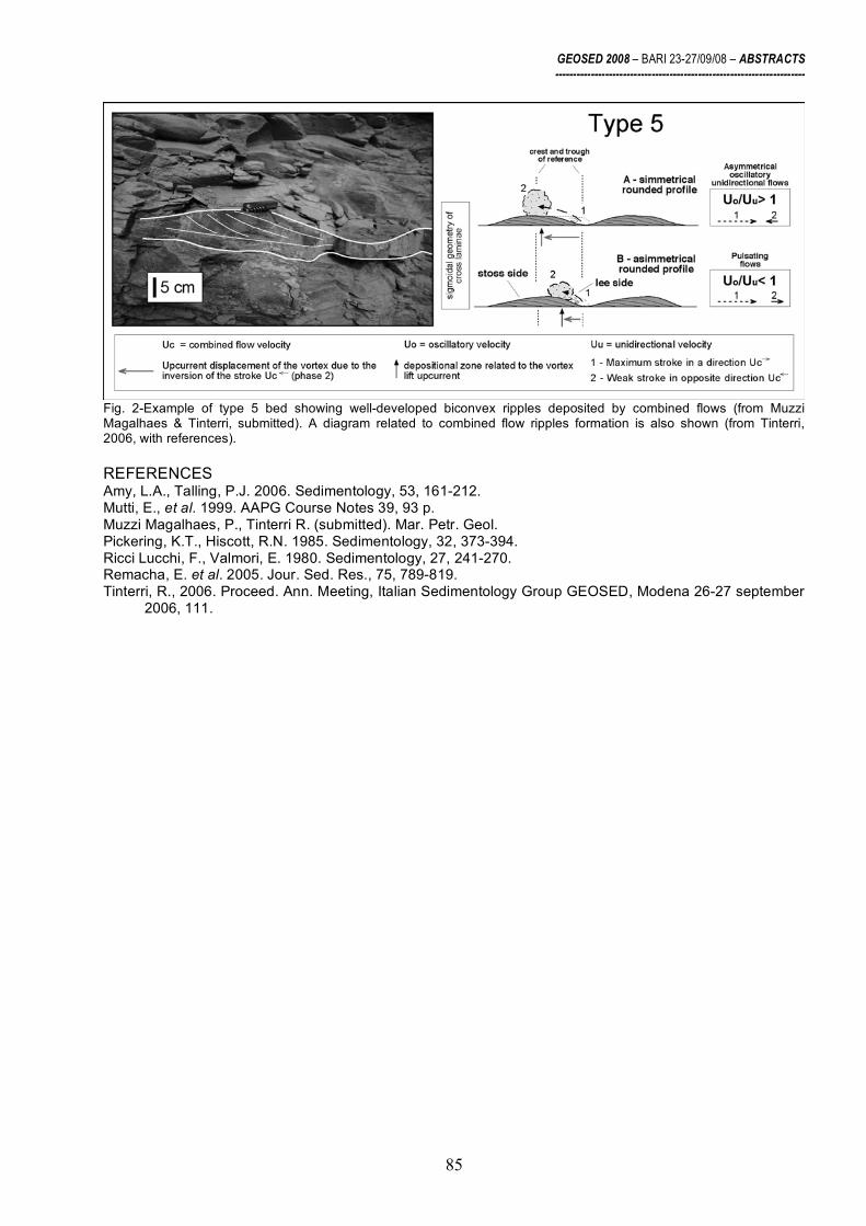
GEOSED 2008 – BARI 23-27/09/08 – ABSTRACTS ----------------------------------------------------------------------
85
Fig. 2-Example of type 5 bed showing well-developed biconvex ripples deposited by combined flows (from Muzzi Magalhaes & Tinterri, submitted). A diagram related to combined flow ripples formation is also shown (from Tinterri, 2006, with references). REFERENCES Amy, L.A., Talling, P.J. 2006. Sedimentology, 53, 161-212. Mutti, E., et al. 1999. AAPG Course Notes 39, 93 p. Muzzi Magalhaes, P., Tinterri R. (submitted). Mar. Petr. Geol. Pickering, K.T., Hiscott, R.N. 1985. Sedimentology, 32, 373-394. Ricci Lucchi, F., Valmori, E. 1980. Sedimentology, 27, 241-270. Remacha, E. et al. 2005. Jour. Sed. Res., 75, 789-819. Tinterri, R., 2006. Proceed. Ann. Meeting, Italian Sedimentology Group GEOSED, Modena 26-27 september
2006, 111.

GEOSED 2008 – BARI 23-27/09/08 – ABSTRACTS ----------------------------------------------------------------------
86
High-resolution stratigraphy of the Langhian to Serravallian portion of the Marnoso-arenacea Formation (northern Apennines, Italy)
P. Muzzi Magalhaes1-2, R. Tinterri1, J.P.B.C. Guerreiro1-2, J.S. Oliveira Filho1-2 and G.
Basta1-2
1 Dipartimento di Scienze della Terra, Università di Parma, 43100 Parma, Italy 2 Petrobras, Petroleo Brasileiro S.A., Rio de Janeiro, Brasil
This work presents the stratigraphy and facies analysis of an interval of about 2,000 metres
in the Langhian and Serravallian stratigraphic succession of the foredeep turbidites of Marnoso-arenacea Formation (MAF). A high-resolution stratigraphic analysis was performed by measuring seven stratigraphic logs between the Sillaro and Marecchia lines for a total thickness of about 6,700 metres (Fig. 1).
Fig.1-Schematic geological map of the MAF between the Santerno and Savio Valleys showing the main thrust fronts. Capital letters (A, B, C, D, E, F) indicate the location of the stratigraphic logs (after Cerrina Feroni et al., 2002).
The correlation of these logs was possible thanks to the presence of numerous key beds characterized by hybrid (Contessa and Io key beds) and carbonate composition (Colombine key beds) sourced by southern carbonate platforms (Ricci Lucchi & Valmori, 1980). The detailed stratigraphic correlation was achieved using a hierarchical approach similar to that utilized by Remacha & Fernandez (2003) in the Hecho Group (south central Pyrenees): first correlating all the main key beds, represented by megaturbidites (Contessa and Colombine key beds) and mass-transport complexes, then the thick beds that can be traced over the entire study area, and finally the thin beds. These high-resolution correlations were used to identify five bed types and relative facies tracts interpreted as related to the interaction between flow efficiency and basin

GEOSED 2008 – BARI 23-27/09/08 – ABSTRACTS ----------------------------------------------------------------------
87
physiography. Therefore, these beds which were used to subdivide the stratigraphic succession into informal stratigraphic units, are as follows (Fig. 2, see also Muzzi Magalhaes et al., this voume):
Type 1 bed: Thick (30 cm < H (bed thickness) < 100 cm) to very thick (H > 100 cm) tripartite beds characterised by internal slurry units that pass downcurrent into thin and fine-grained beds relatively suddenly. These beds are interpreted as being related to sudden decelerations of turbidity currents previously enriched in mud through erosive processes.
Type 2 bed: Very thick (H >> 100 cm) tripartite beds characterised by an internal slump-type chaotic unit. These beds that pass downcurrent into thin and fine-grained beds, are found at the base of structural controlled stratigraphic units and are here interpreted as elements indicating tectonic uplift.
Type 3 bed: Thick (30 cm < H < 100 cm) to very thick (H >> 100 cm) fine-grained beds capped by a thick mudstone unit generally characterised by an increase in thickness downcurrent. These beds are interpreted as associated with rebound and ponding processes.
Type 4 bed: Medium (10 cm < H < 30 cm) to thick (30 cm < H < 100 cm) fine-grained beds that become progressively finer and thinner downcurrent due to deposition from depletive waning turbidity currents.
Type 5 bed: Thin to very thin (H < 10 cm) fine-grained beds characterised by combined flow structures associated with reflection and ponding processes. These are present especially in distal zones or near and above topographic highs.
Using the above-described method, the studied stratigraphic succession was subdivided into five informal stratigraphic units (I, II, III, IV, V) on the basis of syndepositional structural control which is rendered evident not only by structural highs and depocentres but also on the basis of bed characteristic variations highlighted by the progressive increase or decrease in the amount of the five types of bed described above. The syndepositional structural deformation within the MAF has been discussed by various papers (Ricci Lucchi, 1986; Mutti et al. 2002; Roveri et al. 2002, Lucente, 2004). This work, however, on the basis of a high-resolution stratigraphic framework, shows clearly how basin geometry and facies distribution patterns of the MAF were influenced by an evident syndepositional structural control at different temporal and physical scales (Fig. 3, Muzzi Magalhaes & Tinterri, submitted). As a result, the vertical stacking pattern of the MAF records a close interaction between thrust propagation towards the NE and deposition from turbidity currents flowing towards the SE, i.e. parallel to the thrust front. These five units, therefore, record the progressive closure of the foredeep, due to the north-eastward propagation of the thrust sheets. Fig. 3 shows their stratigraphic evolution through the progressive flattenings approach.
Stratigraphic Unit II, included between beds 66 (a type 2 bed) and 138 (Figs. 2, 3), is characterised by an evident structural control highlighted by the presence of a depositional high in northern proximal zones (logs A, B, C; Fig. 1) which favour the presence of type 5 beds and a depocentre in southern distal zones (log D), which favour the creation of type 1 beds (Fig. 3). This basin structure is associated to the north with a tectonic uplift able to generate the Acquadato mass-transport complex (MTC), whose origin depends more probably on the propagation of the Monte Castellaccio thrust (Lucente, 2004). Unit III, on the contrary, corresponds to a period of relatively quiescent tectonic activity (Figs. 3) coinciding with the maximum expansion of the basin where the beds can also be traced up to southern areas of the MAF for about 120x30km (Ricci Lucchi & Valmori, 1980; Amy & Talling, 2006). In this stratigraphic interval, type 3 beds chiefly exemplify the thicker events whereas type 1 beds start to be much less frequent. Unit IV, in turn, is characterised, like Unit II, by a more evident tectonic control but, unlike the latter, the depocentre is located in the north due to an uplift occurring in more southern areas (Figs. 1, 2). The base of Unit IV is characterised by the presence of a type 2 bed and by a progressive bed thinning occurring in its upper part due to the uplift of the southern Verghereto zone (Fig. 1). Unlike Unit II, however, Unit IV is characterised by a progressive increase in type 3 beds and by a progressive decrease in type 1 beds.
The Nasseto and Casaglia MTCes (Fig. 2) mark the passage into the overlying Unit V characterised by a further deformation phase, as well as a segmentation of the basin. This phase is underlined by the presence, in the more proximal zone (log B), of beds constituted by relatively thick massive sandstone facies with high Sandstone/Mudstone ratio, indicating flow decelerations controlled by topography.

GEOSED 2008 – BARI 23-27/09/08 – ABSTRACTS ----------------------------------------------------------------------
88
Fig.2- Diagram summarising the different types of bed identified in the stratigraphic succession studied. A) Types of bed in comparison with classic models, B) Simplified lateral geometries of the facies tracts of beds described in A (from Muzzi Magalhaes & Tinterri, submitted).

GEOSED 2008 – BARI 23-27/09/08 – ABSTRACTS ----------------------------------------------------------------------
89
Along the Ridracoli structural element (Fig. 1), these beds pass downcurrent into Verghereto Marls (Log F, Fig. 2); whereas in more external elements (Log G), the turbidity currents, although able to bypass, are characterised by diffuse reflection processes. The basin segmentation at the time of Unit V is also underlined by the lack of key beds with hybrid and carbonate composition coming from the south. Unit V can be correlated with the Firenzuola and, probably, with Paretaio turbidite systems (in the sense of Mutti et al., 2002) characterized by thick accumulations of sandstone lobes that filled in thrust-related structural depressions. The deposition of Unit V and time equivalent Firenzuola and Paretaio systems, therefore, herald an important phase of basin narrowing occurring at the Serravallian-Tortonian boundary that marks the vertical passage into the MAF outer stage of Ricci Lucchi (1986).
Fig.3-Diagram showing the evolution of the stratigraphic succession studied through the progressive flattenings approach. The vertical distributions of types 1, 2 and 3 beds are indicated in the stratigraphic logs of sketch D (from Muzzi Magalhaes & Tinterri, submitted).

GEOSED 2008 – BARI 23-27/09/08 – ABSTRACTS ----------------------------------------------------------------------
90
REFERENCES Amy, L.A., Talling, P.J. 2006. Sedimentology, 53, 161-212. Cerrina Feroni et al. 2002. Regiona Emilia Romagna e Consiglio Nazionale delle Ricerche (CNR), SELCA
Firenze. Lucente, C.C. 2004. Sed. Geol., 170, 107-134. Mutti, E. et al. 2002. Excursion Guidebook. Agip, 64th EAGE Conference and Exhibition, Florence (Italy), May
27-30, 120 pp. Muzzi Magalhaes, P., Tinterri R. (submitted). Mar. Petr. Geol. Remacha, E., Fernández, L.P. 2003. Mar. Petr. Geol., 20, 711-726. Ricci Lucchi, F. 1986. In: Allen, P.A., Homewood, P. (Eds.), IAS Special Publication 8, Oxford. Blackwell
Scientific, 105-139. Ricci Lucchi, F., Valmori, E. 1980. Sedimentology, 27, 241-270. Roveri, M. et al. 2002. In: Mutti, E., Ricci Lucchi, F., Roveri, M. (Eds.), Excursion Guidebook, 64th EAGE
Conference and Exhibition, Florence (Italy), 120 pp.

GEOSED 2008 – BARI 23-27/09/08 – ABSTRACTS ----------------------------------------------------------------------
91
New preliminary data about the Verghereto Marls (Serravallian-Tortonian, Marnoso-arenacea Formation, northern Apennines, Italy)
P. Muzzi Magalhaes1-2, R. Tinterri1, J.P.B.C. Guerreiro1-2, J.S. Oliveira Filho1-2 and G.
Basta1-2
1 Dipartimento di Scienze della Terra, Università di Parma, 43100 Parma, Italy 2 Petrobras, Petroleo Brasileiro S.A., Rio de Janeiro, Brasil
The high resolution stratigraphic framework presented by Muzzi Magalhaes et al. (this
volume; see also Muzzi Magalhaes & Tinterri, submitted) makes it possible to advance some preliminary considerations about the origin and structural framework of the Verghereto Marls outcropping in the south-eastern zone of the Romagna Apennines (to the east of log F in figure 1).
Fig.1-Schematic geological map of the MAF between the Santerno and Savio Valleys which shows the main thrust fronts (after Cerrina Feroni et al., 2002). Capital letters (A, B, C, D, E, F) indicate the location of the stratigraphic logs.
On the basis of high resolution stratigraphic framework of figure 2, the Verghereto Marls (Serravallian-Late Tortonian in age; Amorosi, 1987; Martelli et al. 1994) belong to stratigraphic Unit V (Fig. 2; see also figure 3 in Muzzi Magalhaes et al., this volume) and are characterized by graded mudstone beds and very fine and thin sandstone beds often showing pinch out geometries, in which meters-thick slump units are also very common. For this reason they are here interpreted as related to dilute turbidity currents able to rise a structural high around the Verghereto zone beginning from the Nasseto mass-transport complex (MTC).
The basal boundary of Unit V, in fact, is marked by the presence of the Casaglia and Nasseto MTCes, that are considered here as time-equivalent, as already suggested by Ricci Lucchi (1981, 1986) and Lucente & Pini (2002, with references). In stratigraphic unit V the beds

GEOSED 2008 – BARI 23-27/09/08 – ABSTRACTS ----------------------------------------------------------------------
92
tend to become thicker, with an upper mudstone unit characterised by a high percentage of silt. More precisely, in the Ridracoli structural element (comprised between M.Nero and M.Castellaccio thrusts, Fig. 1) the thicker beds in the more westerly proximal zone (log B, Figs 1, 2) pass downcurrent into very thin and fine-grained beds associated with the Verghereto Marls. These marls, therefore, are here interpreted as being deposited above a structural high in the Verghereto area, beginning from the Nasseto MTC, and today they are preserved thanks to a large normal fault with NW-SE direction and a dip slip of about 600m (see Fig. 2). The interpretation of this fault, never before reported with such a dip slip (see Bonini, 2006) was made possible by creating a high-resolution stratigraphic framework of the MAF in this zone (Fig. 2; see also Fig. 3 in Muzzi Magalhaes et al. this volume). In particular, this interpretation was influenced by the finding of the Colombina 5 key bed laterally juxtaposed to a mass-transport complex at the base of the Verghereto Marls interpreted here as being time equivalent to the Nasseto mass-transport complex (see Fig. 2). The stratigraphic succession of Units I, II, III in the downthrown block of Verghereto does not outcrop in this area but it is here interpreted as having the same characteristics as log F because in this part of the stratigraphic succession the paleocurrents, bed thickness and facies characteristics remain more or less the same (Muzzi Magalhaes & Tinterri, submitted) and it should be noted that Log F is only 5 kilometres away from the Verghereto area. Moreover, on the basis of data of Muzzi Magalhaes & Tinterri, (submitted) the bed thicknesses start to decrease in a marked way due to the Verghereto high, only during Unit IV, just before the Susinello chaotic body (Fig. 2). This fault, therefore, is interpreted as acting after the deposition of Verghereto Marls and so after the Tortonian and was probably related to a complex structure associated with the Forlì alignment, i.e. the structural alignment between Verghereto and Faenza in figure 1 (see also Roveri et al., 2002, 2003; Bonini, 2006).
Fig. 2 – Simplified geological cross-section of the stratigraphic succession studied in the Ridracoli structural element comprised between the M. Nero and M. Castellaccio thrusts (see Fig. 1 for the location of the logs) (from Muzzi Magalhaes & Tinterri, submitted).

GEOSED 2008 – BARI 23-27/09/08 – ABSTRACTS ----------------------------------------------------------------------
93
REFERENCES Amorosi, A. 1987. Giornale di Geologia, 49/2, 103-110. Bonini, M. 2006. Jour. Geoph. Research, 111, B01404. Cerrina Feroni, A, Martelli, L., Martelli, P., Ottria, G., 2002. Regiona Emilia Romagna e Consiglio Nazionale
delle Ricerche (CNR), SELCA Firenze. Lucente, C.C., Pini, G.A. 2002. In: Mutti, E., Ricci Lucchi, F., Roveri, M. (Eds.), Excursion Guidebook,
Università di Parma and Eni-Agip Division, 64th EAGE Conference and Exhibition, Florence (Italy), 120 pp.
Martelli, L., Farabegoli, E., Benini, A., De Donatis, M., Severi, P., Pizziolo, M., Pignone, R., 1994. La geologia del Foglio 265 – S. Piero in Bagno. Servizio Cartografico e Geologico, Regione Emilia Romagna: Bologna, Firenze, Selca, 117p.
Muzzi Magalhaes, P., Tinterri R. (submitted). Mar. Petr. Geol. Ricci Lucchi, F. 1986. In: Allen, P.A., Homewood, P. (Eds.), IAS Special Publication 8, Oxford. Blackwell
Scientific, 105-139. Roveri, M., Ricci Lucchi, F., Lucente, C.C., Manzi, V., Mutti, E., 2002. In: Mutti, E., Ricci Lucchi, F., Roveri,
M. (Eds.), Excursion Guidebook, Università di Parma and Eni-Agip Division, 64th EAGE Conference and Exhibition, Florence (Italy), 120 pp.
Roveri, M., Manzi, V., Ricci Lucchi, F., Rogledi, S., 2003. Geol. Soc. Am. Bull. 115, 387-405.

GEOSED 2008 – BARI 23-27/09/08 – ABSTRACTS ----------------------------------------------------------------------
94
Stratigraphy of the northern sector of Sant’Arcangelo Basin: new costraints for the tectonic-sedimentary evolution of a Plio-Pleistocene
wedge-top basin in southern apennines (Italy)
V. Onofrio
Dipartimento di Geologia e Geofisica, Università degli Studi di Bari, Via Orabona 4, 70125, Bari.
The wedge-top Sant’Arcangelo Basin in Southern Italy is filled by an up to about 5 km thick
middle Pliocene to middle Pleistocene succession (Mostardini & Merlini, 1986), mainly consisting of conglomerates, sandstones and claystones. Since tectonics occurred during sedimentation, growth geometries developed into the sedimentary succession of the basin. A new detailed geological field survey and an integrated analysis of the stratigraphic and structural features was recently carried out in the northern sector of the Sant’Arcangelo Basin; these studies allowed to recognize several growth structures and to map some unconformity surface within the in-fill succession of the basin, and led to suggest a new stratigraphic subdivision of the Plio-Pleistocene deposits (Onofrio, 2008). The areal distribution of this clastic deposits on map view shows the eastward lateral transition of coarse-grained deposits to fine-grained ones. These deposits are mainly referable to fan delta systems, even if in the upper part of the succession, particularly in the northern sector of the Sant’Arcangelo Basin, early and middle Pleistocene fluvio-lacustrine deposits occur (Caldara et al., 1988; Pieri et al., 1994, 1996; Sabato, 1997; Sabato, 2000; Sabato et al., 2005).
Fig. 1 – Comparision between stratigraphic models proposed by Caldara et al. (1988), Pieri et al. (1994, 1996) and this work for the Plio-Pleistocene succession of the Sant’Arcangelo Basin.
In this study, the stratigraphic subdivision of the in-fill succession of the northern part of the
Sant’Arcangelo Basin partially differs from that one proposed in previous studies by Caldara et al.

GEOSED 2008 – BARI 23-27/09/08 – ABSTRACTS ----------------------------------------------------------------------
95
(1988) and Pieri et al. (1994, 1996) (fig. 1). According to these authors, the succession is made up of some depositional sequences bounded by unconformity surfaces passing from west to east (from the margin of the basin toward the depocenter) to conformity ones. As shown in fig. 1, the main difference from previous studies regards the upper part of the stratigraphic succession, since the Sequence C of Pieri et al. (1994, 1996) contain a previously not recognized unconformity-surface.
Moreover a study of relationships between tectonics and sedimentation was performed with a detailed analysis of growth structures (style of either progressive or angular unconformities; asymmetrical thickening successions; growth faults and folds; growth strata). A relevant conclusion derives from the meaning of the unconformity surface observed between the Aliano and the Sauro-San Lorenzo sequences wich is interpreted to be related to the tectonic activity of a complex strike-slip fault system (Onofrio, 2008).
The results of such analysis suggest that the normal thrust propagation in the accretionary prism controlled the evolution of older sequences, each of them produced by a transgression followed by the progradation of a fan delta systems. On the contrary, the last stage of evolution was strongly controlled by strike-slip tectonics, producing a compartimentalization of the basin floor, with the development of several small endoreic depressions bounded by growing ridges.
REFERENCES Caldara M., Loiacono F., Morlotti E., Pieri P. & Sabato L. (1988) - I depositi plio-pleistocenici della parte nord
del bacino di Sant’Arcangelo (Appennino lucano): caratteri geologici e paleoambientali. Mem. Soc. Geol. It., 41, 391-410.
Mostardini F. & Merlini S. (1986) - Appennino centro meridionale; sezioni geologiche e proposta di modello strutturale. Mem. Soc. Geol. It. 35, 177-202.
Onfrio V. (2008) – Evoluzione tettono-stratigrafica del settore settentrionale del Bacino di Sant’Arcangelo nel Plio-Pleistocene (Appennino meridionale). Tesi di Dottorato, Università degli Studi di Bari.
Pieri P., Sabato L., Loiacono F. & Marino M. (1994) - Il bacino di piggyback di Sant’Arcangelo: evoluzione tettonico-sedimentaria. Boll. Soc. Geol: It., 113, 468-481.
Pieri P., Sabato L. & Marino M. (1996) - The Plio-Pleistocene piggyback Sant’Arcangelo Basin: tectonic and sedimentary evolution. Notes et Mem. geol. Maroc, n° 387, 195-208.
Sabato L. (1997) - Sedimentary and tectonic evolution of a lower-middle Pleistocene lacustrine system in the Sant’Arcangelo piggyback Basin (Southern Italy). Geologica Romana, Vol. XXXIII, 137-145.
Sabato L. (2000) - A lower-middle Pleistocene lacustrine system in late evolutionary stage of the Sant’Arcangelo Basin (Southern Italy). In: E. H. GIERLOWSKI-KORDESCH & K. R. KELTS, Eds., «Lake basin through space time» AAPG Geology studies 46, 543-552.
Sabato L. Bertini A., Masini F., Albianelli A., Napoleone G. & Pieri P. (2005) - The lower and middle Pleistocene geological record of the San Lorenzo succession in the Sant’Arcangelo Basin (Southern Appennines, Italy). Quaternary International, 131, 59-69.

GEOSED 2008 – BARI 23-27/09/08 – ABSTRACTS ----------------------------------------------------------------------
96
Evoluzione di una pocket beach
V. Pascucci and L. Bittau
Dipartimento di Botanica ed Ecologia Vegetale (Sezione di Geologia, Università degli Studi di Sassari) [email protected]
La maggior parte delle spiagge del nord Sardegna è di tipo pocket beach, fortemente in
erosione ed in fase di arretramento. Poche sono stabili e tra queste la Spiaggia Rosa dell’Isola di Budelli nell’Arcipelago di La Maddalena. La spiaggia è sotto tutela integrale da circa 10 anni da parte del Parco nazionale dell’Arcipelago di La Maddalena che ne ha vietato sia l’accesso da terra che quello da mare. Rappresenta, pertanto, un’area chiave per capire se le sole cause antropiche siano la causa principale dell’erosione di questo tipo di spiagge.

GEOSED 2008 – BARI 23-27/09/08 – ABSTRACTS ----------------------------------------------------------------------
97
La Spiaggia Rosa è stata studiata (dal 2003 al 2008) da un punto di vista: sedimentologico, definendo i parametri principali che caratterizzano la sabbia di cui è composta; geologico marino definendo attraverso osservazioni dirette (immersioni) e rilievi Side Scan Sonar (SSS) la morfologia e le strutture sedimentarie presenti sul fondale fino ad una profondità di circa 30 m; temporale attraverso l’analisi delle immagini degli ultimi 40 anni.
La Spiaggia Rosa è orientata NE-SW (?) ed è compresa tra due promontori granitici (monzograniti appartenenti al Basamento Ercinico). La spiaggia emersa è lunga circa 88m e larga 31m, mentre quella sommersa di 300m di larghezza, 190m di lunghezza e si sviluppa fino alla profondità di 7m. Profondità coincidente con il limite superiore della prateria di Posidonia oceanica. E’ composta da sabbie medie costituite per l’80-60% da bioclasti ed il 20-40% da silicoclasti (principalmente quarzo). Il colore rosa della spiaggia (da cui il nome) deriva dall’abbondante presenza di un foraminifero incrostate la Miniacina miniacea che vive attaccato alle parti in ombra (rizomi e radici) di Posidonia oceanica. Questo in alcuni casi rappresenta circa il 16% del totale dei bioclasti. Spiaggia emersa
La sabbia della spiaggia emersa ha una granulometria (21 campioni analizzati) poco variabile sia all’interno dello stesso transetto che tra transetti diversi, con valori compresi tra Mz = 247,4 µm e Mz = 328,0 µm. Netta dominanza delle sabbie medie, ben assortite, con 13 campioni che presentano una curva simmetrica, 9 con una leggera asimmetria negativa, quindi con una coda tendente verso i granuli grossolani (skewness negativo) (Fig. 1). Spiaggia sommersa
La sabbia della spiaggia sommersa (32 campioni analizzati) ha una granulometria con il 50% dei campioni costituito da sabbie medie, delle quali il 56% moderatamente ben assortite il 25% moderatamente assortite e il restante 19% tra ben assortite e male assortite; il 40% dei campioni costituito da sabbie fini, per il 70% moderatamente ben assortite, il 15% moderatamente assortite ed il restante 15% ben assortite. Il 6% del sedimento è rappresentato da sabbie grossolane, mentre circa il 3% è costituito da sabbie molto grossolane. La distribuzione dei sedimenti è del tipo largo-costa con granulometrie decrescenti dal largo verso riva (Fig. 2). Rilievi Side Scan Sonar (SSS)
I rilievi SSS hanno permesso di ricostruire la morfologia del fondale. La spiaggia emersa è suddivisibile in upper shoreface (fino alla profondità di circa 3.5m) ed lower shoreface fino alla profondità di 7m. La prima è caratterizzata da ripples simmetrici, mentre la seconda da ripples asimmetrici e diffusa bioturbazione (verso largo). Una prateria di Cymodocia nodosa occupa buona parte della lower shoreface. Il limite con la prateria di Posidonia è netto. La prateria non è omogenea ma interessata da una serie di canali più o meno sinuosi seguibili fino alla profondità di 30m. I canali sono larghi e ben evidenti verso il limite superiore della prateria, mentre sono molto ramificati verso quello inferiore. Evidenti sono anche i segni di ancoraggio delle barche. Dinamica della Spiaggia Rosa
Dai dati emersi l’apporto sedimentario normale alla spiaggia è da mare verso terra. La componente legata al corso d’acqua effimero è stata (almeno durante gli anni di monitoraggio) scarsa. Due sono le tipologie di movimento dei sedimenti: 1) largo-costa; 2) convergente sulla battigia.
Il movimento largo costa avviene essenzialmente tramite i canali presenti nella prateria di Posidonia. In particolare in quelli ortogonali alla spiaggia si muovono i sedimenti bioclastici (inclusa Miniacina), mentre in quello a SW, parallelo alla spiaggia, si muovono i sedimenti silicoclastici. Il movimento lungo la battigia è del tipo orario nella porzione di sinistra (guardando dal mare) ed antiorario in quella di destra. La risultante è una spiaggia leggermente asimmetrica sia da un punto di vista granulometrico che geometrico. Analisi di immagine
Sono state prese in considerazione le immagine aeree della Spiaggia Rosa degli ultimi 40 anni. Queste mostrano chiaramente come la spiaggia sia in sostanziale equilibrio con minime variazioni delle linea di riva.

GEOSED 2008 – BARI 23-27/09/08 – ABSTRACTS ----------------------------------------------------------------------
98

GEOSED 2008 – BARI 23-27/09/08 – ABSTRACTS ----------------------------------------------------------------------
99
CONCLUSIONI La Spiaggia Rosa è una pocket beach in equilibrio da almeno 40 anni. I sedimenti che
costituiscono la spiaggia sono per circa l’80% di natura bioclastica. L’area sorgente dei sedimenti è la prateria di Posidonia. La particolare posizione della spiaggia, protetta dai venti di NW (Maestrale) e W (Ponente) dominanti nell’area dell’Arcipelago della Maddalena è uno dei fattori principali dell’equilibrio della spiaggia. Il buono stato della prateria di Posidonia antistante la spiaggia è di sicuro l’elemento fondamentale per continuarne la preservazione.

GEOSED 2008 – BARI 23-27/09/08 – ABSTRACTS ----------------------------------------------------------------------
100
Caratteri deposizionali delle successioni plioceniche di “wedge-top basin” affioranti tra gli abitati di San Mauro Forte, Oliveto Lucano e Garaguso (MT, Italia meridionale)
M. Pepe
Dipartimento di Geologia e Geofisica, Università degli Studi di Bari, Campus, Via E. Orabona, 4, 70100 Bari,
Italia
Le successioni plioceniche oggetto di studio affiorano in Basilicata, tra gli abitati di San Mauro Forte, Oliveto Lucano e Garaguso (MT), lungo il fronte esterno della catena appenninica. L’assetto geologico di quest’area è caratterizzato dalla presenza di un prisma di accrezione neogenico, costituito da unità pelagiche e torbiditiche cretacico-mioceniche, su cui poggiano in discordanza depositi pliocenici di wedge-top di ambiente variabile da costiero ad emipelagico.
Un rilevamento geologico di dettaglio (in scala 1:10.000) ha portato all’individuazione, nell’ambito dell’intera successione pliocenica, di tre sintemi, delimitati da discordanze angolari. Nell’ambito di tali sintemi sono state analizzate 18 sezioni litostratigrafiche di dettaglio, e sono stati realizzati una serie di fotomosaici. In particolare è stata eseguita l’analisi di facies e pertanto sono stati ricavati i principali processi sedimentari che hanno operato, oltre che gli ambienti deposizionali.
Il primo sintema, di età Pliocene inferiore, presenta uno spessore di circa 150 m. Tale sintema, la cui base non è affiorante, è costituito da sabbie massive fini, che passano verso l’alto a silt argillosi con intercalazioni sabbiose, con abbondanti frustoli vegetali e bioclasti. La successione di facies osservata in questi depositi indica la transizione da un ambiente di fronte deltizia, soggetto a sedimentazione per graduale aggradazione di sabbie sotto la costante alimentazione legata a flussi iperpicnali, ad un ambiente di prodelta, dove avviene sedimentazione per decantazione e trazione della coda di materiale fine dei flussi iperpicnali.
Il secondo sintema, di età compresa fra il Pliocene inferiore e il Pliocene medio-superiore (Maiorano, 2000), raggiunge uno spessore di circa 120 m. Nel complesso si tratta di depositi silicoclastici, costituiti alla base da conglomerati sabbiosi canalizzati, che passano verso l’alto a conglomerati sabbiosi con geometria lenticolare e quindi a banchi sabbioso-conglomeratici tabulari, progressivamente più spessi verso l’alto. In particolare, i depositi conglomeratico-sabbiosi canalizzati presentano al loro interno set di strati di spessore pluri-decimetrico, caratterizzati da gradazione diretta e da presenza localmente di lamine ricche di frustoli vegetali, e sono riferibili a stream flows in ambiente di piana deltizia. I depositi conglomeratico-sabbiosi immediatamente sovrastanti, a geometria lenticolare, sono costituiti da set di strati che raggiungono lo spessore di 1 m e sono estesi lateralmente fino a 4 m; ciascun set è costituito da strati bipartiti, caratterizzati da un livello basale di conglomerati, che presentano gradazione diretta o inversa e ciottoli localmente embriciati, ed un sovrastante livello sabbioso. Questi depositi sono complessivamente riferibili a barre di foce ghiaioso-sabbiose, alimentate da hyperconcentrated-flood flows (sensu Sohn et al., 1999). Attraverso un passaggio rapido, si passa a depositi sabbioso-conglomeratici che chiudono il secondo sintema, costituiti da banchi tabulari progressivamente più spessi verso l’alto e che raggiungono lo spessore di 5 m. Ciascun banco presenta una netta bipartizione tra la porzione grossolana basale e la sovrastante porzione sabbiosa e laminata. Questi depositi sono complessivamente riferibili a lobi di fronte deltizia, la cui sedimentazione è legata alla continua alimentazione legata a flussi iperpicnali turbolenti ad elevata densità. Nel complesso, la successione di facies osservata in questo sintema, che presenta un complessivo fining e deepening-upward, è riferibile alla retrogradazione di sistemi deltizi del tipo flood-dominated deltaic systems descritti da Mutti et al. (1996). Il trend che si osserva nella successione verticale si osserva anche lateralmente, e corrisponde ad un facies tract (sensu Mutti et al., 1996), prodotto dalla trasformazione lungo pendio di flussi iperpicnali, che da hyperconcentrated-flood flows in corrispondenza delle barre di foce evolvono a flussi turbolenti ad elevata densità verso bacino.
Il terzo sintema, di età Pliocene medio-superiore, è spesso circa 250 m, ed è costituito per i 70 m basali da depositi misti (arenarie ibride), che passano verso l’alto ad argille siltose. I depositi misti presentano successioni di facies estremamente variabili lateralmente. In particolare, nei pressi dell’abitato di San Mauro Forte, la successione dei depositi misti è rappresentata alla base da arenarie e calciruditi bioclastiche con strati gibbosi, talvolta massivi, talvolta con laminazione

GEOSED 2008 – BARI 23-27/09/08 – ABSTRACTS ----------------------------------------------------------------------
101
obliqua inclinata a basso angolo con immersioni opposte. Verso l’alto si passa a corpi a stratificazione piana obliqua a vario angolo, costituiti da set di strati con lamine alternativamente bioclastiche e silicoclastiche ben segregate, che formano successioni fining e thinning-upward. Tali depositi sono complessivamente riferibili ad un ambiente sommerso ad elevato idrodinamismo, in cui prevale la trazione a grande scala. Lateralmente, presso il Fosso Canala, i depositi misti sono invece costituiti alla base da arenarie e sabbie siltose organizzate in corpi cuneiformi spessi poche decine di metri. Ciascun corpo cuneiforme è a sua volta costituito da foreset spessi pochi decimetri e inclinati di circa 20°. Gli strati sono caratterizzati da una porzione basale massiva e più grossolana ed una porzione laminata sovrastante. Verso l’alto si passa a corpi a stratificazione piana obliqua a vario angolo. I caratteri di facies osservati nella successione affiorante lungo il Fosso Canala indicano une sedimentazione in ambiente sommerso, sotto il forte controllo della gravità (sediment gravity flows) e, nella parte alta, di processi trattivi a grande grande scala. Infine, il terzo sintema si chiude con depositi pelitici massivi o laminati, spessi circa 180 m. I caratteri di facies osservati nell’intera successione del terzo sintema sono, quindi, riferibili ad ambienti di shoreface, passanti ad ambienti di piattaforma s.l.
BIBLIOGRAFIA Maiorano P. (2000) – Integrated calcareous nannofossil and foraminiferal biostratigraphy of Pliocene
terrigenous deposits from the Southern Apennines (Lucania, Italy). Boll. Soc. Paleont. Ital., 39 (2), 139-155 pp.
Mutti E., Davoli G., Tinterri R., Zavala C. (1996) – The Importance of Ancient Fluvio-Deltaic Systems Dominated by Catastrophic Flooding in Tectonically Active Basins. Mem. Sci. Geol., 48, 233-291 pp.
Sohn Y.K., Rhee C.W., Kim B.C. (1999) – Debris Flow and Hyperconcentrated Flood-Flow Deposits in an Alluvial Fan, Northwestern Part of the Cretaceous Yongdong Basin, Central Korea. The Journal of Geology, 107, 111-132 pp.
GEOSED 2008 – BARI 23-27/09/08 – ABSTRACTS ----------------------------------------------------------------------
102
The Apulian Foreland and the Calcarenite di Gravina Formation
P. Pieri
Dipartimento di Geologia e Geofisica, Università di Bari The middle-upper Pliocene to lower Pleistocene Calcarenite di Gravina Formation crops out
on the outer margin of the Bradanic Trough and on the Apulian Foreland and unconformably overlies faulted strata of the Apulian carbonate platform. The Apulian platform was a relict of Mesozoic rifting and passive margin development across the Adria, an African lithospheric promontory which is considered a present-day separate plate. The Apulian platform became an emerged region at the end of the Mesozoic; only thin and discontinuous Cenozoic shallow-marine carbonates covered marginal areas of the wide Mesozoic platform. During the Neogene, the Apulian platform became part of the foreland of the southern-Apennines chain. As a consequence of the eastward roll-back of the subducting Adria Plate, the western part of the Apulian platform was overthrust by the "allochthon" and successively involved in thrusting whereas, from early Pliocene time, the eastern part of the Apulian platform (the remaining part of the platform not reached by thrusting) underwent a progressive increase in regional subsidence. A thin (no more than a few tens of metres thick) middle-upper Pliocene to lower Pleistocene mantle of bioclastic and/or lithoclastic carbonates deposited on the faulted rocks of the Apulian Foreland. The lower boundary of these carbonates is a long-term ravinement surface abraded onto the bedrock and regionally these rocks represent the Calcarenite di Gravina Formation, which was deposited in shallow-marine systems backstepping onto the flanks of the Apulian Foreland highs. From NW to SE and from W to E carbonate systems were diachronously covered by hemipelagites of the Argille subappennine Formation derived from the Apennines thrust belt.
Marine carbonates of the Calcarenite di Gravina Formation crop out from the present-day sea level (along the Adriatic and Ionian cliffed coasts) up to more than 400 m in elevation. The highest outcrops are subaerially eroded, whilst lower outcrops on the flank of the foreland highs are at times either conformably overlain by the Argille subappennine Formation or disconformably overlain by marine and/or alluvial terrace deposits. In short, the Calcarenite di Gravina Formation represents a significant marker to constraint the most recent geological hystory of the Apulian Foreland.

GEOSED 2008 – BARI 23-27/09/08 – ABSTRACTS ----------------------------------------------------------------------
103
Geology of the F° 438 “Bari” (CARG Puglia – new Geologic map of Italy, scale 1: 50.000)
P. Pieri and L. Spalluto
Dipartimento di Geologia e Geofisica. Università degli Studi di Bari. Via E. Orabona, 4.
70125 Bari (Italy), [email protected]
The F° 438 “Bari” (scale 1: 50.000) lies in the northern part of the Murge area (central part of the Apulia region, southern Italy) and represents a sector of the Apulian foreland (Auctt.). The Apulian Foreland shows a uniform crustal structure with a Variscan basement and a 6-7 km thick Mesozoic-Cenozoic sedimentary cover mainly made up of Jurassic-Cretaceous dolostones and limestones developed in a large intra-oceanic platform (the Apulian Platform; D’Argenio, 1974). A 3 km thick Cretaceous carbonate succession in the Murge area mainly records the development of a broad inner-platform system (Ricchetti, 1975).
Two main lithostratigraphic units, separated by a Turonian unconformity, have been recognised in the inner-shelf Cretaceous succession of Murge: the “Calcare di Bari” (Valanginian - Early Turonian?), about 2000 m in thickness, and the “Calcare di Altamura” (Senonian), about 1000 m in thickness (e.g. Ricchetti, 1975; Ciaranfi et al., 1988).
Cretaceous deposits of the the Calcare di Bari Fm crop out extensively in the F° 438 “Bari” with a thickness of 470-480 m. Five lithostratigraphic intervals have been recognized inside a fairly monotonous succession formed in a broad inner platform setting. Only the uppermost interval shows lithofacies associations deposited in an open platform setting. As a consequence, the Calcare di Bari succession is made up of biopeloidal and peloidal wackestones/packstones alternated to stromatolitic bindstones and to fenestral mudstones. Mollusks-rich (mostly rudist shells) floatstones/rudstones are less developed than previous lithofacies and are usually concentrated in three different layers, few tens of metres thick, showing almost a constant association of mollusks species. These layers are easily were formerly used as reference layers (“livelli guida”) for lithostratigraphic correlations. As these layers show significant changes in lateral thickness, they cannot be used for precise stratigraphic correlations but only for an estimate of the stratigraphic position in the whole outcropping succession. Anyway, the informal nomenclature of the previous edition of the Geologic Map of Italy (“livello Palese” in the first stratigraphic interval, “livello Sannicandro” in the fourth one and “livello Toritto” in the fifth one) is here confirmed. Biostratigraphic data allowed us to refer the age of the whole outcropping succession of the Calcare di Bari Fm to the late Albian-late Cenomanian.
The lower Pleistocene Calcarenite di Gravina Fm unconformably lies on the Calcare di Bari Fm. The lower boundary is transgressive and is locally marked by reddish residual deposits (terra rossa) and/or by brackish silty deposits gradually passing upward to shallow-water calcarenites rich in bioclasts. Floatstones/rudstones with mollusks, red algae-bearing floatstones and bioclastic packstones/grainstones are usually alternated in the succession and suggest deposition in high-energy and normal saline beach environments. The thickness of this unit ranges from few metres to 20 m.
The argille subappenine fm. conformably lies on the Calcarenite di Gravina Fm. This unit crops is made up of burrowed clays, silts and fine grained sands. This unit deposited in relatively distal shelf environments (from the lower shoreface to the offshore). The total thickness is about 8 m and the age is early Pleistocene.
The Murge supersynthem groups all the marine terraced deposits previously attributed to the “Depositi marini terrazzati” unit (Ciaranfi et al., 1988). It unconformably lies on all older units and consists of a heterogeneous assemblage of mixed siliciclastic and carbonate sediments formed in shallow-marine and transitional environments. The formation of these deposits took place in the general regressive phase that, starting from the latest early Pleistocene, interested all the Apulian foreland due to the regional uplifting. This latter, in combination with the Pleistocene glacioeustatic oscillations produced several relative sea-level changes which determined the distribution of these sediments to different quotes above the present day sea-level position. The thickness of the five synthem forming the supersynthem is usually few metres and the age ranges from middle to late Pleistocene.

GEOSED 2008 – BARI 23-27/09/08 – ABSTRACTS ----------------------------------------------------------------------
104
The “lame delle Murge” supersynthem groups all the terraced alluvial deposits cropping out in the studied area. These deposits unconformably lie on the Calcare di Bari Fm. and are placed at different quotes on the present day position of the little canyons, locally named “lame”. These deposits consists of either well-cemented or poorly cemented conglomerates with a residual silty-sandy reddish matrix. The thickness of these deposits is few metres and the age is late Pleistocene-Holocene.
As regards the structural features of deposits outcropping in the F° 438 “Bari”, it is possible to observe a S-SW trending monoclinal dissected by several faults and folded by gentle anticlines and synclines, affecting only the Cretaceous succession. Quaternary units are undeformed and show a tabular arrangement.
Main structures are represented by high-angle NW-SE, WNW-ESE and E-W oriented faults, dipping towards NE or SW, which show extensional and/or transtensional features and delimit morphostructural depressions filled by Quaternary deposits. In the southwestern part of the studied area two of these faults bound a narrow graben (“Murge basse” graben) filled by the Calcarenite di Gravina Fm. In the eastern and northeastern part of the sheet a system of conjugated faults delimit a broad morphostructural depression filled by Quaternary deposits. High-angle N-S and NE-SW oriented faults, dipping towards NW or SE, intersect faults of the previous system and locally offset them suggesting a younger tectonic activity.
REFERENCES Ciaranfi, N., Pieri, P., Ricchetti, G., 1988. Note alla Carta Geologica delle Murge e del Salento (Puglia
centro-meridionale). Mem. Soc. Geol. It., 41, 449-460. D’Argenio, B., 1974. Le piattaforme carbonatiche periadriatiche. Una rassegna di problemi nel quadro
geodinamico Mesozoico dell’area mediterranea. Mem. Soc. Geol. It., 13 (2), 137-159. Ricchetti, G., 1975. Nuovi dati stratigrafici sul Cretaceo delle Murge emersi da indagini nel sottosuolo. Boll.
Soc. Geol. It. 94, 1083-1108.

GEOSED 2008 – BARI 23-27/09/08 – ABSTRACTS ----------------------------------------------------------------------
105
Holocene palaeohydrography and stratigraphy of the south Venetian Plain
S. Piovan and P. Mozzi
Department of Geography – University of Padova, via Del Santo 26, 35123 Padova ITALY
In the low plain the Adige River sedimentary system is confined to the north by the Brenta River megafan and to the south by the Po sedimentary system (Fontana et al., in press). This latter boundary is not well defined, as branches of the Po River occasionally interested the Adige alluvial plain and, vice versa, Adige channels crossed the Po system.
The study area is located in the distal portion of the Adige alluvial system between the cities of Rovigo and Adria (fig. 1) and is characterized by a complex network of alluvial ridges formed by the aggradation of sandy deposits along the river branch during the Holocene avulsions by Adige and Po rivers.
Geomorphological evidence shows a number of alluvial ridges. Among them, those of the Adige and the Adigetto rivers and that of the so-called “Po di Adria” palaeochannel (Veggiani, 1972) that bifurcates south of Rovigo. The northern branch, on which Rovigo, Sarzano, Saline, Chiaroni and Cona lie, is regarded as the “Po northernmost branch” (Castiglioni, 1978) and crosses the present-day Adige River alluvial ridge north of Chiaroni (fig. 1).
Fig. 1 – Geomorphological sketch of the study area with the cross sections location.
The reconstruction of the palaeohydrographical conditions during the Late Holocene of this area has been mainly based on remote sensing interpretation and archaeological data (Veggiani, 1972; Peretto, 1986; Marcolongo, 1987; Cremonini, 2007). In this research, new chronostratigraphical and petrographical data are presented, in order to provide better insights on the Holocene palaeohydrography and stratigraphy of this area.
Remote sensing and digital terrain model analysis allowed to analyze the geomorphology of the study area, in order to recognize the major landforms. About 90 manual boreholes placed in 7 cross sections down to the depth of 5-9 m have been carried out in order to define the stratigraphy of the major palaeochannel deposits and their relationships with the floodplain. The cross sections
GEOSED 2008 – BARI 23-27/09/08 – ABSTRACTS ----------------------------------------------------------------------
106
have been located in Saline and Chiaroni (San Martino di Venezze, Rovigo), Ca’ Motte (Villadose, Rovigo), Cona (Venezia), Pettorazza Grimani (Rovigo) and Ramalto (Adria, Rovigo). An open section has been also studied in Sarzano (Rovigo) (see fig. 1).
Radiocarbon dating of peat layers and petrographical analysis have been carried out to determine the time of activation of the palaeochannels and the composition of the sands in order to relate them with the appropriate fluvial basin, either Adige or Po.
Geomorphological, stratigraphical and petrographical results confirm the presence of a Po branch from Fratta Polesine through Sarzano to Cona which activity began after 4237-4979 cal. BP in Saline 1 and after 4141-4712 cal. BP in Cona, and produced the Villadose crevasse splay. The palaeochannel deactivation dates back in the Late Bronze Age as confirmed by archaeological settlement in Saline that lies on the natural levee deposits.
In Cona 1, a calcic horizon has been reached at the mean depth of -7.5 m a.s.l. It can be correlated with the “caranto” palaeosoil of the Lagoon of Venice (Mozzi et al. 2003), produced during a sub-aerial exposure of the sediment after the last glacial maximum lowstand phase. In this interpretation, this buried soil marks the top of the Late Pleistocene sequence. As evidenced in the whole Venetian-Friulian Plain, the alluvial sequence is characterized by a sedimentary hiatus since 14500 to 8000 BP (Fontana et al., in press). After this hiatus, the transgressive phase began and the sea level rise caused an increase of the underground water table with the setting of swamp conditions, which characterized the floodplain during the maximum flooding (6000-5500 BP in the Po delta region (Stefani & Vincenzi, 2005).
The peat deposits found in Cona, Saline and Chiaroni at the mean depth of -4 m a.s.l. may be correlated with those formed, in the alluvial plain behind the coast line, during the transgressive and maximum flooding phase (Bondesan et al., 1995). In the hypothesis that in Cona the sedimentation possibly began again around 8000 BP, the radiocarbon dating of the peat layer at 4435-5306 cal. BP, just ca. 1 m above the caranto palaeosoil, supports the presence of an Early Holocene sedimentary hiatus in the alluvial series.
The overlying radiocarbon dating (4141-4712 cal. BP), at -4.5 m a.s.l., shows that the aggradation of the floodplain continues during the 3rd millennium B.C. with a deposition of about 3 m in 3500 years. After this date, a sandy channel body, which can be interpreted as related to a Po River palaeochannel, cut the floodplain and the deposition seems to increase. In the following 1500 years, calculated from the dated peat layer and the topographic surface that corresponds to the Late Bronze Age, 4.5 to 7.5 m of sediment were deposited, in the floodplain and in the channel-levee system, respectively.
The chronostratigraphy of Cona section shows that in the study area, the highstand phase and the aggradation of the alluvial ridge of Po northern branch starts since about 4000 cal. BP.
In Pettorazza, there is evidence of floodplain aggradation during the 2nd millennium B.C. until the 1st B.C.-4th century A.D. In this time interval a first sand body, belong to the Adige River, was deposited and the peat on top of these sands was formed in the 11th-13th century A.D. Thus, the main sand body, which corresponds to the modern alluvial ridge of the Adige River, formed in the Middle Ages.
Some authors (Peretto, 1986; Balista, 2004) have suggested the presence of a southern branch of Adige River active during the Roman Age, which produced the alluvial ridge cut, in more recent times, by the Adigetto channel. Stratigraphical results show, in Ramalto, no important sand body in correspondence of the Adigetto alluvial ridge. On the other hand, the “Fasanara” alluvial ridge, about 1 km to the north, corresponds to an important sand body. In the Ramalto cross-section the stratigraphy of a branch of the Po di Adria is also presented.
REFERENCES Balista, C.,2004. Il territorio cambia idrografia: la rotta della Cucca. In G. Leonardi, S. (ed.), Archeologia e
idrografia del Veronese a cent’anni dalla deviazione del fiume Guà (1904-2004). Atti della Giornata di Studi “La necropoli del Fiume Nuovo” – 15 maggio 2004.
Bondesan, M. et al., 1995. New evidence on the evolution of the Po-delta coastal plain during the Holocene. Quaternary International, 29/30, 105-110.
Cremonini, S., 2007. Some remarks on the evolution of the Po River plain (Italy) over the last four millennia. China-Italy bilateral symposium on the coastal zone: evolution and safeguard, Bologna, Italy.

GEOSED 2008 – BARI 23-27/09/08 – ABSTRACTS ----------------------------------------------------------------------
107
Fontana, A. et al., (in press). Alluvial megafans in the Venetian-Friulian Plain (north-eastern Italy): Evidence of sedimentary and erosive phases during Late Pleistocene and Holocene. Quaternary International (2007), doi:10.1016/j.quaint.2007.08.044.
Marcolongo, B., 1987. Ricostruzione paleoidrografica attraverso interpretazione di immagini telerilevate. In B. Marcolongo (ed.), Paleoidrografia tardoquaternaria della pianura veneta sudoccidentale e il suo significato in una ricostruzione paleoclimatica (pp. 6-9). Padova: C.N.R.
Mozzi, P., et al., 2003. Stratigraphy, palaeopedology and palynology of Late Pleistocene and Holocene deposits in the landward sector of the Lagoon of Venice (Italy), in relation to the “caranto” level. Il Quaternario, 16(1b), 193-210.
Peretto, R., 1986. Ambiente e strutture antropiche nell'antico Polesine. In AA.VV. (ed.), L'antico Polesine. Testimonianze archeologiche e paleoambientali. (pp. 21-100) Padova: Antoniana s.p.a.
Stefani, M. and Vincenzi, S., 2005. The interplay of eustasy, climate and human activity in the late Quaternary depositional evolution and sedimentary architecture of the Po Delta system. Marine Geology, 222-223, 19-48.
Veggiani, A., 1972. Il ramo del Po di Adria nella tarda Età del Bronzo. Padusa, 8(3-4), 123-126.

GEOSED 2008 – BARI 23-27/09/08 – ABSTRACTS ----------------------------------------------------------------------
108
Gli eventi anossici del medio Cretacico e loro significato a scala globale
I. Premoli Silva
University of Milano, Dipartimento di Scienze della Terra ‘Ardito Desio’, via Mangiagalli 34, 20133 Milano
Negli anni ‘70 l’esplorazione oceanica ha permesso di recuperare sedimenti eccezionalmente ricchi di materia organica, detti black shales, nelle successioni pelagiche cretaciche negli oceani Atlantico, Pacifico e Indiano. Questi ‘black shales’ sono risultati coevi con litologie analoghe affioranti nel dominio tetideo suggerendo il carattere globale della deposizione di sedimenti ricchi in Corg durante intervalli-tempo, denominati Oceanic Anoxic Events (OAEs) (Schlanger & Jenkyns, 1976): l’Aptiano–Albiano (OAE1), il Cenomaniano–Turoniano
(OAE2) e il Coniaciano-Santoniano (OAE3). Dettagliate analisi biostratigrafiche hanno permesso di datare con precisione i singoli eventi e di suddividere il lungo intervallo OAE1 nei subeventi OAE1a, OAE1b, OAE1c e OAE1d. Tra questi eventi anossici, OAE1a (Aptiano inferiore) e OAE2 (Cenomaniano sommitale) hanno significato globale e la loro espressione sedimentaria più spettacolare è rappresentata dal Livello Selli e dal Livello Bonarelli nel Bacino Umbro-Marchigiano, la loro regione tipo. Gli altri eventi apparentemente sembrano avere un significato più regionale.
Studi interdisciplinari sulle successioni pelagiche hanno permesso di caratterizzare gli episodi OAE1a e OAE2 da un punto vista sedimentologico, paleontologico e geochimico (organico, inorganico e isotopico). In particolare, entrambi gli eventi sono caratterizzati da una marcata diminuzione del contenuto e/o assenza in CaCO3, e talora dalla presenza di livelli ricchi in radiolari. Dal punto di vista paleontologico i due episodi presentano pecularità proprie: il Livello Selli è caratterizzato dalla temporanea scomparsa dei nannoconidi tra i nannofossili calcarei in concomitanza con una riduzione nel numero di specie tra i radiolari e i foraminiferi planctonici. Il Livello Bonarelli coincide con un importante cambiamento tra i radiolari e i nannofossili calcarei e con l' estinzione dei foraminiferi planctonici più specialisti, le rotalipore, associata alla proliferazione di taxa opportunisti (heterohelicidi). I cambiamenti del plancton sia calcareo che siliceo osservati nei livelli ricchi in Corg indicano un incremento della fertilità nelle acque superficiali, correlabile con risalite più vigorose. L' intensità della perturbazione, tuttavia, è stata maggiore durante la deposizione del Livello Bonarelli e si è tradotta in cambiamenti importanti nel plancton calcareo e siliceo coevi con la formazione di anossia al fondo. Durante la deposizione del Livello Selli, invece, la perturbazione è stata in generale meno intensa: nei gruppi planctonici non si osservano cambiamenti maggiori, ma si hanno solo scomparse temporanee, e le condizioni al fondo sono generalmente solo disossiche.
Inoltre, OAE1a e OAE2 si associano con un’importante escursione isotopica del carbonio nei carbonati e/o nella materia organica causata da una perturbazione del ciclo del carbonio a scala globale. Una relazione temporale tra questi eventi ed episodi vulcanici/tettonici maggiori è testimoniato dalle ampie escursioni positive e negative del rapporto 87Sr/86Sr. Gli aumenti dell’attività vulcanica durante la formazione dell’ Ontong Java (e Manihiki) Plateau e della placca Caraibica si pensa abbiano causato le risposte geologiche associate rispettivamente con gli eventi OAE1a e OAE2. L’eccesso di CO2 vulcanogenica in atmosfera ha molto probabilmente cambiato il clima verso un regime a effetto serra accelerando l’alterazione meteorica continentale e incrementando il contenuto in nutrienti delle acque superficiali oceaniche via apporto fluviale. Una più alta fertilità negli oceani è stata probabilmente innescata anche direttamente dall’attività vulcanica sottomarina che ha introdotto enormi quantità di elementi biolimitanti tramite le venute idrotermali.
Il medio Cretacico è un periodo di condizioni climatiche estreme caratterizzato da un prolungato regime di ‘greenhouse’. L’intero sistema oceano/atmosfera esperimenta una ‘rivoluzione’ che è registrata nelle successioni sedimentarie a scala globale. Non sorprende, quindi, che gli OAEs siano concentrati nell’intervallo Aptiano-Turoniano quando l’attività vulcanica parossistica ha certamente interessato il clima e la struttura chimico-fisica degli oceani. OAE1a e OAE2 si correlano con l’inizio e climax del regime ad “effetto serra” del Cretacico medio, l’episodio di riscaldamento più estremo degli ultimi 150 My. L’importante escursione positiva degli isotopi del carbonio (fino a 2 x più alta dei valori base) durante entrambi gli eventi è interpretata generalmente

GEOSED 2008 – BARI 23-27/09/08 – ABSTRACTS ----------------------------------------------------------------------
109
come dovuta al seppellimento accelerato di materia organica durante episodi di incremento della produttività primaria.
Un’altra marcata escursione positiva del δ13C è stata evidenziata nel Valanginiano, o Weissert Event, dapprima nelle successioni delle Alpi meridionali, indi praticamente lungo tutto il margine settentrionale della Tetide, e registrata dall’ambiente continentale al pelagico. Contrariamente agli eventi OAE1a e OAE2, l’escursione valanginiana è marcata da deposizione di black shales solo in rari casi. Tuttavia, il recupero relativamente recente di black shale di età valanginiana, con tenori di TOC >3% t.w. allo Shatsky Rise (NW Pacifico), sembrerebbe indicare che anche il Weissert Event ha valenza globale e non solo tetidea. REFERENCE Schlanger S.O. and Jenkyns H.C., 1976. Cretaceous oceanic anoxic events: Causes and consequences.
Geologie en Mijnbouw, 55, 179–184.

GEOSED 2008 – BARI 23-27/09/08 – ABSTRACTS ----------------------------------------------------------------------
110
Large-scale mass wasting processes in the Messinian Ciminna Basin
(northern Sicily)
M. Roveri1, S. Lugli
2 and V. Manzi
1
1 Dipartimento di Scienze della Terra - Università di Parma, Via G.P. Usberti, 157/A - 43100, Parma, Italy
2 Dipartimento di Scienze della Terra - Università di Modena e Reggio Emilia Largo S. Eufemia, 19 - 41100,
Modena, Italy
A general consensus has been reached in recent times on the chronology of events related to the Messinian salinity crisis (MSC) of the Mediterranean basin (see Roveri et al., 2008). The MSC onset at around 5.96 Ma (Krijgsman et al., 1999) is considered synchronous at a Mediterranean-scale and a first evaporitic stage (5.96-5.6 Ma) has been recognized which is characterized by the cyclical deposition of massive selenite in shallow-water semi-closed sub-basins and of organic-rich mudstones and dolostones in deeper basins (Manzi et al., 2007; Roveri et al., 2008). These deposits form the so called Lower Evaporites unit and show an impressive similarity in terms of facies, stacking pattern and number of evaporitic cycles (up to 16), allowing detailed basinwide correlations (Lugli et al., 2008).
The Ciminna Basin (northern Sicily) is usually considered an anomaly in the general MSC
framework, as here the local Lower Evaporites overlay a composite evaporitic unit, consisting of both primary massive selenite and resedimented gypsum deposits (Lo Cicero and Catalano, 1976; Catalano et al., 1976), through an intervening marine mudstone horizon. The Lower Evaporites are unconformably overlain by upper Messinian clastics and lower Pliocene marine marls of the Trubi Fm.
Based on biostratigraphic data and regional-scale geological considerations, this anomalous Messinian succession has been considered to record a precursor evaporitic event aged at around 6.22 Ma (Sprovieri et al., 1997; Lo Cicero et al., 1997). An alternative hypothesis claiming for a tectonic duplication of the Lower Evaporites (Ruggieri and Torre, 1997) has been refused by Lo Cicero et al. (1997), based on structural and stratigraphic considerations.
A detailed facies analysis led us to recognize the perfect correspondence in terms of facies
association and number of cycles of the primary massive selenite characterizing the lower and upper evaporitic unit of the Ciminna succession. Based on their peculiar facies characteristics, it can be documented that they both include evaporitic cycles 3 to 6 of the Lower Evaporites unit recognized throughout the Mediterranean. In other words, massive selenites of the lower and upper unit are identical and belong to a largely incomplete, base and top-missing Lower Evaporites unit. As a consequence, to account for their vertical superposition a suitable mechanism is needed.
Field observations suggest that the composite lower evaporitic unit of Ciminna actually
consists of an array of collapsed blocks of Lower Evaporites massive selenite which are onlapped by mainly clastic gypsum deposits. We interpret this succession as a base of slope complex formed in front of a thrust-related anticline undergoing uplift and progressive dismantling through large-scale mass-wasting processes during a intra-Messinian phase of tectonic activity. In this context, also the upper evaporitic unit is here considered a huge slab of Lower Evaporites emplaced on top of the lower unit through mainly gravitative processes related to retrogressive sliding.
This interpretation rules out the occurrence of a precursor evaporitic event in the Ciminna
basin and may solve a long-lived controversy by framing this succession into a regional context of highly dynamic tectonic and sedimentary evolution.
Large-scale mass-wasting processes involving the Messinian Lower Evaporites are a common feature of tectonically active basins of the Mediterranean; they are favoured by the strong mechanical contrast between massive selenite units and underlying mudstone deposits and have
GEOSED 2008 – BARI 23-27/09/08 – ABSTRACTS ----------------------------------------------------------------------
111
been observed in the Northern Apennines (Roveri et al., 2003) as well as in Sicily (Belice and inner Caltanissetta basins, see Roveri et al., 2006). Their correct recognition in the different sub-basins is a fundamental step toward the full comprehension of the complex events that affected the Mediterranean during the Messinian salinity crisis.
REFERENCES Catalano R., Renda P. and Slaczka A., 1976. Redeposited gypsum in the evaporitic sequence of the
Ciminna Basin (Sicily). Memorie della Società Geologica Italiana, 16, 83-93. Lo Cicero G. et al. 1997. The Ciminna Messinian Evaporitic Basin – Cyclical sedimentation and eustatic
control in a transpressive tectonic setting. In: Field workshop in Western Sicily (R. Catalano, ed.). Eurobasin Conference Guidebook, 71-85.
Krijgsman W. et al., 1999. Chronology, causes and progression of the Messinian salinity crisis. Nature, 400, 652-655.
Lo Cicero G. and Catalano R., 1976. Facies and petrography of some Messinian evaporites of the Ciminna Basin (Sicily). Memorie della Società Geologica Italiana, 16, 63-81.
Lugli S., Manzi V. and Roveri M., 2008. New facies interpretation of the Messinian evaporites in the Mediterranean. CIESM, 2008. The Messinian Salinity Crisis mega-deposits to microbiology - A consensus report. CIESM Workshop Monographs, 33, 67-72.
Manzi V. et al., 2007. The deep-water counterpart of the Messinian Lower Evaporites in the Apennine foredeep: The Fanantello section (Northern Apennines, Italy). Palaeogeography, Palaeoclimatology, Palaeoecology, 251, 470-499.
Roveri M., Manzi V., Ricci Lucchi F. and Rogledi S., 2003. Sedimentary and tectonic evolution of the Vena del Gesso basin (Northern Apennines, Italy): Implications for the onset of the Messinian salinity crisis. Geological Society of America Bulletin, 115, 387-40.
Roveri M. et al., 2006. Clastic vs. primary precipitated evaporites in the Messinian Sicilian basins. R.C.M.N.S. International Congress Parma 2006 “The Messinian salinity crisis revisited II” post-congress Field-trip. Acta Naturalia De “L’Ateneo Parmense”, 42-1, 125-199.
Roveri M., Lugli S., Manzi V. and Schreiber B.C., 2008. The shallow- to deep-water record of the Messinian salinity crisis: new insights from Sicily, Calabria and Apennine basins. CIESM, 2008. The Messinian Salinity Crisis mega-deposits to microbiology - A consensus report. CIESM Workshop Monographs 33, 73–82. Monaco.
Ruggieri G. and Torre G., 1997. Geologia del lembo neoautoctono di Ciminna (Palermo). Il Naturalista siciliano, S. IV, 21, 109-127.
Sprovieri R. et al., 1997. Biostratigraphic interpretation of the Upper Miocene Ciminna Basin. A re-evaluation of the lithological sequence. In: R. Catalano (Ed.): Time scale and basin dynamics. Sicily, the adjacent Mediterranean and other natural laboratories. Abs. vol. 8° Eurobasin-Euroconference of the ILP Task Force on the Origin of Sedimentary Basins, 7-13 June, Palermo (Italy), 114.

GEOSED 2008 – BARI 23-27/09/08 – ABSTRACTS ----------------------------------------------------------------------
112
Caratterizzazione geoambientale del margine nordest della Piana Campana in provincia di Caserta
D. Ruberti, M. Vigliotti, R. Marzaioli and A. Pacifico
Dipartimento di Scienze Ambientali, Seconda Università degli Studi di Napoli; Via Vivaldi, 43 – 81100
Caserta; tel. 0823 274609; [email protected]
Sul territorio della Regione Campania sono ben visibili gli effetti di alcune attività antropiche che seppure economicamente necessarie, hanno comportato, nel corso degli anni, modificazioni talvolta irreversibili per le differenti componenti ambientali.
Studi condotti nel settore nord-orientale della Piana Campana, in provincia di Caserta, un’area intensamente urbanizzata sede di numerosi siti di estrazione “a fossa” e di stoccaggio, anche incontrollato, di rifiuti, mostrano che esistono elementi di forte compromissione del sistema suolo-sottosuolo.
L’obiettivo è una caratterizzazione ambientale della porzione nord-est della Piana Campana, in considerazione della normativa nazionale e regionale vigente in chiave di conoscenza dell’assetto geologico ed idrogeologico.
Il contesto geoambientale è stato desunto attraverso analisi condotte in ambiente GIS, mediante sovrapposizione topologica, che hanno consentito di definire le relazioni esistenti tra la tipologia di uso del suolo, i siti inquinati, i siti estrattivi e le caratteristiche geologiche in situ, al fine di valutare il potenziale di impatto sulla falda idrica.
L’area di analisi occupa il settore nord-orientale della Piana Campana alla base dei versanti
mesozoici meridionali dei Monti Tifatini. Impostata su depositi piroclastici in giacitura primaria (DI GIROLAMO, 1968), subordinati colluvioni e depositi di dilavamento, forma un ampio glacis pedemontano (PUTIGNANO et al., 2007) raccordato ai rilievi collinari attraverso cunei e lobi detritici costituiti da depositi vulcanici rimaneggiati, alternati a detrito calcareo anche grossolano di differente età (PUTIGNANO et al., 2007).
La caratterizzazione geologica del sottosuolo è stata preceduta dalla ricerca e raccolta di dati desumibili dalla produzione scientifica a carattere geologico e geologico-applicativo e da relazioni geologico-tecniche realizzate a seguito di indagini dirette. L’eterogeneità dei dati, espressa attraverso le molteplici descrizioni delle unità litologiche riconosciute, ha richiesto un’omogenizzazione realizzata sulla base di dati bibliografici, di mirate sezioni geologiche e/o correlazioni tra sondaggi, validate poi attraverso le osservazioni dirette di campo.
In profondità, a sedimenti marini e transizionali, con intercalati depositi ignimbritici, si sovrappongono i depositi della formazione del Tufo Grigio Campano, che alla base dei monti di Caserta raggiungono i massimi spessori (circa 80 m). Processi di autometamorfismo hanno dato origine alla formazione secondaria del tufo giallo zeolitizzato e del tufo grigio, caratterizzati da differenti gradi di cementazione che, talora, presentano buone caratteristiche di consistenza tali da giustificare l’elevato numero di cave “a fossa” nell’area. Un livello discontinuo di paleosuolo marca il passaggio tra il TGC e gli esili depositi vulcanoclastici del Tufo Giallo Napoletano. Le unità stratigrafiche e litologiche riconosciute sono riassunte nella Tabella 1.
I dati validati sono stati raccolti in un geodatabase relazionale che consente di considerare
una singola entità sotto molteplici aspetti (litologici, stratigrafici), unitamente ai parametri petrofisici, alle caratteristiche geomeccaniche ed eventualmente idrogeologiche. L’utilizzo di RockWorks 2006 ha permesso di ottenere modelli bi- e tridimensionali per l’intero spessore di sottosuolo investigato.
Ai fini della caratterizzazione superficiale del territorio è stata adoperata la Carta
dell’Utilizzazione Agricola dei Suoli della Campania che rappresenta porzioni di territorio caratterizzate da una determinata copertura e uso del suolo in funzione delle produzioni agricole, diversificate anche in base alle necessità di irrigazione.
La CUAS evidenzia una prevalenza di superfici urbanizzate ed artificiali e di aree in cui le pratiche agricole condotte (colture intercalari da sovescio) prevedono frequenti arature con conseguente dissodamento del terreno che in occasione di periodi di intense precipitazioni

GEOSED 2008 – BARI 23-27/09/08 – ABSTRACTS ----------------------------------------------------------------------
113
meteoriche possono determinare una maggiore lisciviazione dell’azoto. Molto basso, invece, è nel complesso il grado di naturalità.
Sul territorio si distribuiscono numerosi siti inquinati e cave, prevalentemente a fossa. Alcune aree a seguito del continuo accumulo di rifiuti, in considerazione della quantità e dello spazio occupato, hanno assunto carattere definitivo di discarica abusiva, accogliendo anche rifiuti speciali e pericolosi. Siti inquinati e cave occupano settori ai margini delle aree urbane malgrado alcuni siano ubicati all’interno delle stesse. Seppure siano diffusi in maniera piuttosto uniforme in tutta l’area di pianura, tuttavia è evidente una zona critica circoscritta alle aree di Maddaloni, S. Marco Ev. e S. Nicola la Strada.
Tab. 1 - Unità stratigrafiche e litostratigrafiche riconosciute. L’insieme delle coperture recenti (deposi di falda, depositi di versante, etc.), sono stati raggruppati con la denominazione di Copertura detritica. Tali Coperture sono state suddivise,
secondo i criteri del rilevamento CARG per i depositi Quaternari, in relazione ai processi genetici e alle litologie.
La ricostruzione 3D integrata della superficie topografica, dei corpi geologici e della superficie piezometrica mette in evidenza che nel settore settentrionale la riconosciuta soggiacenza della falda principale di circa 30 m (CORNIELLO, 2004) è costituita da circa 25 m di tufo che, con un valore medio-basso di permeabilità (1,0·10-3 ÷ 6,75·10-3 m/s), costituisce un discreto filtro naturale a potenziali inquinanti. Viceversa, nel settore sud-orientale, dove la soggiacenza della falda e la potenza del banco di tufo si riducono a pochi metri, e la permeabilità dei depositi superficiali è medio-alta, si determinano condizioni di estrema vulnerabilità. Queste condizioni divengono drammatiche nelle aree di cava, laddove il pelo libero della falda è prossimo al fondo cava.
Le risultanze di queste analisi messe in relazione con la distribuzione dei siti inquinati e delle
cave pongono in evidenza l’estrema vulnerabilità dell’area agli impatti antropici sia nelle porzioni più superficiali (suolo) che in quelle profonde (sottosuolo), fino ad interessare la falda.
Tali valutazioni possono rappresentare un utile strumento per successive indagini e per la realizzazione di progetti aventi come scopo la pianificazione razionale del territorio.
BIBLIOGRAFIA Corniello A., 2004. Caratterizzazione idrogeologica del territorio dell’Autorità di del Bacino Nord–Occidentale
della Campania. In AA.VV.: Lo stato delle conoscenze acquisite sulle acque sotterranee del Bacino Nord-Occidentale propedeutico alla redazione del Piano di tutela delle Acque. Volume II, pp 9-47. TPS - Selca.
Di Girolamo P., 1968. Petrografia dei tufi campani: il processo di pipernizzazione (tufo → tufo pipernoide → piperno). Rend. Accad. Sci. Fis. Mat., ser. 4, 35, 329-394.
Putignano M.L. et al., 2007. Evoluzione tardo quaternaria del margine casertano della Piana Campana (Italia meridionale). Boll. Soc. Geol. It., 126, fasc. 1, pp. 11-24.

GEOSED 2008 – BARI 23-27/09/08 – ABSTRACTS ----------------------------------------------------------------------
114
Insights into flood-dominated, mixed siliciclastic-volcaniclastic fan deltas: very high-resolution seismic examples off the Amalfi cliffed coast,
Eastern Tyrrhenian Sea M. Sacchi1, F. Molisso1, C. Violante1, E. Esposito1, D. Insinga1, C. Lubritto2, S. Porfido1
and T. Tóth3
1 Istituto per l'Ambiente Marino Costiero (IAMC) - CNR, Napoli, Calata P.ta di Massa, Porto di Napoli, 80133 - Napoli, Italy
2 Dipartimento di Scienze Ambientali, Seconda Università di Napoli, Via Vivaldi, 43 – 81100 Caserta, Italy
3 Geomega Ltd., Mester u. 4, 1095 Budapest, Hungary INTRODUCTION
In recent years, deltaic depositional settings at the mouth of small rivers of the Mediterranean and other temperate regions have received growing attention, due to the relevance of these facies associations in the understanding of the late Quaternary evolution of inner shelf depositional systems and their interaction with fluvio deltaic processes, seafloor instability of delta slopes, coastal volcanism, active tectonics, and the climatic regime (Nava-Sanchez et al., 1999; Lobo et al., 2006; Sacchi et al., 2005; McConnico & Basset, 2007).
Sediment dispersal underwater is directly related to supply by rivers. In the case of bedrock rivers and streams of temperate regions that form fan deltas along high-relief sea-cliffed coasts (Nava-Sanchez et al., 1999; Fernández-Salas et al., 2003; Hasiotis e al., 2006; Lobo et al., 2006), the fluvial regime is basically controlled by episodic, but sometimes catastrophic discharges which cause flooding of the fans. Long-term development of fan deltas obviously reflects a wide range of possible processes but variations in sediment supply and in the morphoclimatic regime appear to be major controls (e.g., Colella & Prior, 1990). Among the factors that may have significant impact on fan delta construction, are, hence, the frequency of recurrence of exceptional river floods, mudflows and explosive eruptions (pyroclastic falls, surges and flows) from coastal volcanoes. These processes can all induce the supply of large volumes of loose or poorly consolidated sediment into the delta system and over vast areas of the continental shelf (Cinque et al., 1997; Lirer et al., 2001; Sacchi et al., 2005; Sulpizio et al., 2006; Bisson et al., 2007). THE SORRENTO PENINSULA CLIFFED COAST
The Amalfi coast is located on the southern slope of the Sorrento Peninsula. The peninsula is a major Quaternary morpho-structural unit of the western flank of Southern Apennines and forms a narrow and elevated mountain range (up to 1444 m) that separates two major embayments of the eastern Tyrrhenian margin, namely the Naples and Salerno Bays. It is mostly formed by a pile of Mesozoic carbonate rocks, covered by Tertiary to Quaternary siliciclastic and pyroclastic units and is deeply cut by a complex pattern of bedrock rivers and channels characterized by relatively small catchment areas and pronounced disequilibrium of the stream profiles . These rivers show a distinct seasonality and a torrential behaviour (Esposito et al., 2004; Liquete et al., 2005).
Coarse-grained coastal alluvial fans confined by narrow valleys at the mouth of the major streams are relatively common in this setting. They are formed by deposition from flash floods, that occur during heavy rain storms. The delivery of sediments towards the coastal fans is favoured by the steep slopes and the loose material of a wide size range that includes, bedrock river gravel, slope-weathering products, soil, and unconsolidated volcaniclastics deriving from the explosive activity of the Vesuvius and Campi Flegrei Volcanoes (Sigurdsson et al., 1985; Cioni et al., 1992; Yokoyama and Marturano, 1997; Sulpizio et al., 2006; Bisson et al. 2007).
3. THE FAN DELTAS OF THE AMALFI COAST
This study is based on the interpretation of a very high-resolution (IKB-Seistec), single-channel reflection seismic survey carried out on the Amalfi inner shelf, between Salerno and

GEOSED 2008 – BARI 23-27/09/08 – ABSTRACTS ----------------------------------------------------------------------
115
Amalfi, in July 2004. Seistec profiles have been calibrated with gravity core data that have allowed for bed-to-bed correlation with the seismic record, and 14C dating of major event beds.
Seismic interpretation showed that the fan delta system imaged off the Amalfi rocky coast developed after the AD 79 plinian eruption of the Vesuvius. During this time interval of c. 2000 yrs, both sea-level oscillation and tectonic subsidence/uplift were practically negligible in terms of influence on the overall stratigraphic architecture of the inner shelf system, and the main factor controlling stratal geometries and patterns, were likely the rates and modes of sediment supply.
A prominent gravity-driven instability and deformation of sediments was detected at various stratigraphic levels, within the delta slopes, along with the substantial lack of subaerial delta plain components, or other subaqueous segregation zones for sediments (e.g. distributary channels, levee complexes). This suggest that the stratal geometry of the fan deltas was dominantly dictated by the effective transfer of sediments by hyperpicnal (e.g. inertia, turbidity) flows directly fed by river floodings to the lower segments of the delta slopes.
Ostensibly, the various phases of subaqueous delta growth were also controlled by the interplay of two main factors, namely a) the accelerated erosion of slopes on the alluvial basins by effective sheetwash and flashfloods during and/or following periods of intense volcanism that resulted in the delivery of considerable volumes of volcaniclastic debris and loose sediments to the foreshore area and b) the varying erosive potential of the river basin slopes under the changing morphoclimatic regimes over the last 2 kyrs.
The major change detectable in the stratal geometries of the fan deltas occurring in the early medieval time may be associated with the onset of a period of climatic cooling, known as Early Medieval cool period (c. AD 500-AD 800), that developed immediately after the Roman Warm period. Further minor changes in the stratal patterns of the delta foresets, that are consistently imaged by the seismic record in all the individual fan deltas of the Amalfi coast may be tentatively correlated with the Medieval Warm Period (c. AD 900-AD1100) and the Little Ice Age (c. AD 1400-AD 1850).
REFERENCES Bisson M. et al., 2007. Volcaniclastic debris-flow occurrences in the Campania region (Southern Italy)
and their relation to HoloceneLate Pleistocene pyroclastic fall deposits: implications for large-scale hazard mapping. Bull. Vulcanol. 70,157-167.
Cinque A. et al., 1997. Volcanism, tectonics and recent geomorphological change in the Bay of Napoli. Suppl. Geogr. Fis. Dinam. Quat. 3, 123-141.
Colella A. and Prior B.D. (eds.), 1990. Coarse-grained deltas. Int. Ass. of Sedimenologists, Spec. Pubb. No. 10, 357 pp.
Esposito E. et al. (Eds.), 2004. Il nubifragio dell'ottobre 1954 a Vietri sul Mare-Costa di Amalfi Salerno. CNR GNDCI, Pubbl. n. 2870, p. 381.
Fernández-Salas L.M. et al., 2003. High-resolution architecture of late Holocene highstand Prodeltaic deposits from southern Spain: the imprint of high-frequency climatic and relative sea-level changes. Continental Shelf Research 23, 10371054.
Hasiotis T. et al., 2006. Fan delta development and processes offshore a seasonal river in a seismically active region, NW Gulf of Corinth. Geo-Marine Letters, Volume 26, Number 4 199-211
Lirer L. et al., 2001. Occurrence of inter-eruption debris-flow and hyperconcentrated food-flow deposits on Vesuvio volcano, Italy. Sedimentary Geology 139, 151167.
Liquete C. et al., 2005. Mediterranean river systems of Andalusia, southern Spain, and associated deltas: a source to sink approach. Marine Geology 222–223, 471–495.
Lobo F.J. et al., 2006. The sea-floor morphology of a Mediterranean shelf fed by small rivers, northern Alboran Sea margin. Continental Shelf Research 26 (2006) 26072628.
McConnico T.S. and Bassett Kari N., 2007. Gravelly Gilbert-type fan delta on the Conway Coast, New Zealand: Foreset depositional processes and clast imbrications. Sedimentary Geology 198 (2007) 147166.
Nava-Sanchez E.H. et al., 1999, The El Coyote fan delta: a wave-dominated example from the Gulf of California, Mexico: Quaternary International, v. 56, p. 129140.
Sacchi M. et al.,2005. Stratigraphic signature of the Vesuvius 79 AD event off the Sarno prodelta system, Naples Bay. Mar. Geol. 222223, 443469.
Sulpizio R. et al., 2006. The Holocene syneruptive volcaniclastic debris flowin theVesuvian area: geological data as a guide for hazard assessment. In: Siebe, C., Macias, J.L., Aguirre-Diaz, G.J.

GEOSED 2008 – BARI 23-27/09/08 – ABSTRACTS ----------------------------------------------------------------------
116
(Eds.) NeogeneQuaternary continental margin volcanism: a perspective from Mexico. Geol. Soc. Am. Special Paper, vol. 402, pp. 203221.
Yokoyama, T.and Marturano, A., 1997. Volcanic products of the Vesuvius eruption in AD 79 at Pompeii, Italy. Opusc. Pompeiana VII, 132.

GEOSED 2008 – BARI 23-27/09/08 – ABSTRACTS ----------------------------------------------------------------------
117
A threefold research aimed at the reconstruction of an artificial dune (Migliarino – San Rossore – Massaciuccoli National Park, Pisa, Tuscany, Italy):
preliminary data
G. Sarti, D. Bertoni, L. Ciulli, I. Consoloni and S. Giacomelli
Dipartimento di Scienze della Terra, Università di Pisa – Via Santa Maria, 53 – 56126 Pisa
This research has been carried out through a collaboration between the Department of Earth Sciences of the University of Pisa and the Province of Pisa within the BeachMed project. It has worked out a better morpho-sedimentologic definition of a beach-ridge dune system primarily aimed at the reconstruction of an artificial dune in front of the Presidential House. The study area belongs to the Pisan coast and extends for about 23 km. It nearly coincides with the boundaries of the Migliarino – San Rossore – Massaciuccoli National Park, and is exactly comprised between Torre del Lago Puccini (Lucca) to the north and Tirrenia (Pisa) to the south; the landward limit of the area corresponds to the last outcropping beach-dune alignment. This huge dune system has formed due to the progradation of the Arno River delta during the last 2000 years and at present is subjected to strong erosion processes.
A multidisciplinary approach has been used in this work. A detailed morpho-sedimentologic survey (1:2000) has allowed to group the dune systems into steady, semimobile and frontal dunes. Dunes which are no more subjected to processes that have previously led to their formation are called “steady”: they are fixed and characterized by arboreous vegetation. Dunes which can be at times subjected to erosion and accretion processes and are characterized by shrubbery are called “semimobile”. “Frontal” dunes are active and covered with typical psammophile vegetation.
Moreover, a series of sampling has been conducted for a more accurate sedimentologic definition of the area. Grain-size analyses have provided the granulometric range most suitable to the dynamics processes that affect this sector of the coast. First of all, five transects have been traced and samples have been taken starting from the beachface to the oldest outcropping beach-dune alignment. On the beach, the beachface, the berms and the backshore have been sampled; on the frontal dunes, the stoss-side, the crest and the lee-side; and on the steady and semimobile dunes, the crest and the interdune areas. The transects have been traced by significant locations, like updrift and downdrift of the Arno and Serchio rivers, and close to the Morto Vecchio River. Data processing has showed i) a decrease in grain-size moving towards the oldest dunes and ii) a slightly coarser grain-size of the crest dune sands in respect to the interdune deposits. These trends are further confirmed by sand vs silt plots.
At last, provenance data derive from the petrographic analysis of a selected group of samples previously collected for the grain-size analysis and few more from Arno and Serchio rivers. The petrographic analysis has showed compositional variations within each transect, most notably the decrease in calcium carbonate moving towards the oldest outcropping beach-dune alignment. Preliminary data demonstrate that Arno River has represented the major source of sediments.
In conclusion, this study has produced a better knowledge about this beach-dune system, and it has even provided useful data on how to improve and optimize any coastal protection structure local authorities might decide to set up.

GEOSED 2008 – BARI 23-27/09/08 – ABSTRACTS ----------------------------------------------------------------------
118
Quantificazione dell’apporto di sedimenti provenienti dall’erosione delle sponde del fiume Cecina
L. B. Teruggi, M. Rinaldi, D. Ostuni and I. Chiaverini
Dipartimento di Ingegneria Civile e Ambientale, Università degli Studi di Firenze, Via S.Marta, 3 – 50139
Firenze, Italia. [email protected] Introduzione e area di studio
La migrazione laterale dei corsi d’acqua alluvionali è originata principalmente dall’erosione delle sponde. Tradizionalmente, l’arretramento delle sponde fluviali viene considerato soprattutto per i danni prodotti alle infrastrutture, le perdite di terreno ed altri effetti negativi. Recentemente si è sempre più accresciuta la consapevolezza dei benefici associati all’erosione delle sponde, ad esempio per la rigenerazione e l’evoluzione degli habitat fisici negli ecosistemi acquatici e ripariali (si veda ad es. Florsheim et al., 2008).
L’erosione di sponde fluviali deriva da una complessa interazione di vari processi (Rinaldi and Darby, 2008) ed esercita un ruolo importante nella dinamica fluviale apportando sedimenti che alimentano il trasporto solido del sistema fluviale. In alcuni fiumi è stato calcolato che il contributo dell’erosione di sponde nel bilancio annuale di sedimenti a scala di bacino può essere del 80% del totale (Simon and Darby, 2002).
L’obbiettivo di questo studio è quello di analizzare le variazioni laterali di un corso d’acqua, quantificare i sedimenti apportati dall’erosione di sponda ed analizzarne le loro variazione spazio-temporali. Lo studio si è svolto lungo il corso alluvionale del fiume Cecina, fiume ghiaioso con alveo a fondo mobile della Toscana centro-meridionale. Il bacino idrografico è di circa 900 km², la lunghezza del fiume è intorno ai 79 km. Il monitoraggio di dettaglio di una sponda in erosione è stato effettuato per un tratto di circa 150 m e 5 m di altezza, subito a monte della confluenza del Torrente Sterza con il F. Cecina.
Metodi
I dati analizzati provengono da fonti diverse: (a) materiale cartografico e foto aeree di diversi anni con i quali si è analizzata la migrazione laterale temporale e spaziale lungo il corso d’acqua; (b) dati rilevati sul terreno ottenuti dal campionamento e rilevamento sedimentologico e geomorfologico dei tratti di sponda instabili; (c) monitoraggio di dettaglio eseguito con la fotogrammetria terrestre su una sponda rappresentativa ed in erosione.
La migrazione laterale è stata analizzata attraverso l’esame di cartografia storica e foto aeree disponibili tramite un Sistema di Informazione Geografica (GIS) creato con il software ArcGis 9.2 . Utilizzando lo stesso software è stato possibile rettificare e georeferenziare tutte l’immagini disponibili del corso d’acqua nel periodo compreso tra il 1883 e il 2004. Questa metodologia ha permesso di confrontare e digitalizzare gli alvei dei diversi anni e consentire la misura di parametri di tipo planimetrico come la larghezza e sinuosità (Rinaldi et al., 2008).
Per comprendere la distribuzione spaziale dei fenomeni di erosione di sponda recenti ed attuali, è stato effettuato un confronto delle foto aeree del 1994 e del 2004. In questo caso il fiume è stato suddiviso in tratti di 250 m; per ogni tratto è stata valutata l’area media annua di materiale asportato. E’ stato possibile poi ricavare una stima dei volumi erosi in base alle misure di geometria delle sponde nei vari tratti effettuate durante i rilievi sul terreno.
I dati provenienti dal rilevamento sul terreno consistono nella caratterizzazione sedimentologica e geomorfologica di 36 tratti di sponda effettuata utilizzando la scheda proposta da Thorne (1998), in abbinamento alla quale sono state effettuate varie misure granulometriche dei materiali di sponda.
Le immagini digitali derivanti dai rilevamenti fotogrammetrici terrestri sono state elaborate mediante stereorestitutore digitate adoperando il software Micromap. Il tratto di sponda monitorato con la fotogrammetria digitale terrestre è rilevato 2 volte all’anno, prima e dopo del periodo delle piogge durante un periodo di 5 anni. Sono stati effettuati i modelli digitali della sponda (DTM) per ognuno dei rilevamenti ed è stato calcolato il volume eroso.

GEOSED 2008 – BARI 23-27/09/08 – ABSTRACTS ----------------------------------------------------------------------
119
Fig. 1: Variazione dell’erosione di sponda media annuale misurata per segmenti di 250m nel periodo compreso tra l’anno 1994 e l’anno 2004. Risultati
Le misure planimetriche dell’alveo attivo che provengono dalle fotografie aeree hanno permesso di stimare le variazioni spaziali e temporali del canale ed i tassi di erosione di sponda a scala decennale. Invece l’analisi di dettaglio in un tratto rappresentativo del corso, dove le misure provengono dall’analisi della fotogrammetria terrestre, ha permesso di stimare i tassi di erosione di sponda a scala mensile.
Dal confronto delle misure planimetriche effettuate nei diversi anni si è potuto osservare un forte restringimento dell’alveo attivo ed un incremento della sinuosità del fiume Cecina (Rinaldi et al., 2008).
I risultati ottenuti dall’analisi dell’erosione di sponda integrati con i dati geomorfologici di ogni tratto di sponda rilevata forniscono una quantificazione del volume di materiale asportato dalle sponde nell’intervallo temporale compresso tra l’anno 1994 ed l’anno 2004 (Fig. 1). Correlando questi risultati con i dati sedimentologici rilevati nel campo possiamo indicare che il 63% del materiale eroso dalle sponde corrisponde a sedimenti ghiaiosi/sabbiosi mentre che il 37% restante corrisponde a materiale coesivo limo argilloso.
Il volume totale di materiale eroso dalle sponde è di 45.600 m3/anno lungo 60 km dell’alveo del F. Cecina ove è stata svolta l’indagine, corrispondente a un apporto di sedimenti dalle sponde da 760 m3/km per anno.
E’ stato possibile poi confrontare tali valori medi per unità di lunghezza con quelli relativi ad un tratto rappresentativo particolarmente dinamico, soggetto a monitoraggio attraverso fotogrammetria terrestre. La sponda soggetta a monitoraggio figura tra le sponde con i maggiori volumi di materiali erosi nel periodo di dieci anni (9.400 m3/km per anno ). Integrando le sezioni ottenute dai rilevamenti fotogrammetrici con i dati sedimentologici rilevati nel campo, è stato possibile ricavare una stima precisa dei contributi volumetrici per ognuna delle varie unità litologiche presenti in tale tratto (Tab. 1).
Tab. 1: Percentuali dei volumi erosi secondo le diverse litologie calcolati dall’analisi fotogrammetrica per un periodo di 6 mesi
I risultati ottenuti finora rappresentano un primo passo per lo sviluppo di ricerche future che
contribuiscano a fornire le conoscenze necessarie per una buona gestione dei sedimenti presenti

GEOSED 2008 – BARI 23-27/09/08 – ABSTRACTS ----------------------------------------------------------------------
120
nell’alveo del fiume Cecina. Un aspetto importante è ad esempio quello di analizzare quale percentuale del trasporto solido al fondo e del trasporto totale derivi dall’arretramento complessivo delle sponde, e determinare inoltre l’apporto quantitativo derivante da tali processi all’incremento dei sedimenti sabbiosi alla foce. Ringraziamenti
La ricerca è stata finanziata con fondi MIUR, progetto: ‘Incentivazione alla mobilità di studiosi stranieri e italiani residenti all’estero’. Gli autori ringraziano la Regione Toscana e la Provincia di Pisa, Servizio Difesa del Suolo, che hanno contribuito con materiale cartografico e foto aeree. BIBLIOGRAFIA Florsheim, J. L. et al., 2008. Bank Erosion as a Desirable Attribute of Rivers. BioScience, 58, N°6, 519-529. Rinaldi, M. and Darby, S.E., 2008. Modelling river-bank-erosion processes and mass failure mechanisms:
progress towards fully coupled simulations. In: Habersack H., Piégay H. and Rinaldi M. (Eds), Gravel-Bed Rivers 6 - From Process Understanding to River Restoration. Series Developments in Earth Surface Processes, 11, Elsevier, Netherlands, 213-239.
Rinaldi, M. et al., 2008. Dinamica recente ed attuale di alvei fluviali: alcuni casi di studio dell’Appennino Settentrionale. Il Quaternario, in stampa.
Simon, A. and Darby, S.E., 2002. Effectiveness of grade-control structures in reducing erosion along incised river channels: The case of Hotophia Creek, Mississippi. Geomorphology, 42, 229-254.
Thorne C.R., 1998. Stream reconnaissance handbook. Geomorphological investigation and analysis of river channels. John Wiley & Sons, Chichester.

GEOSED 2008 – BARI 23-27/09/08 – ABSTRACTS ----------------------------------------------------------------------
121
Classification of ecological status of the Río Quequén Grande basin, Buenos Aires, Argentina
L. B. Teruggi1, S. Sala2, M. J. Kristensen2, E. Caporali1, M. A. Casco2 and A. Cefarelli2
1 Dipartimento di Ingegneria Civile e Ambientale, Università degli Studi di Firenze, Via S. Marta, 3 – 50139
Firenze 2 Facultad de Ciencias Naturales y Museo, Paseo del Bosque. 1900. La Plata, Argentina
Introduction
Although biological monitoring is considered a fundamental tool in Europe (European Union, 2000) and in other developed countries’ water legislations, in Argentina it only concerns research and there are no standardized methodologies to be applied in water management activities. Rivers have been managed from a political and an engineering point of view and the associated specific environmental problems (e.g. floods, pollution) have been solved with local measures leading to the collapse of living riverine systems. In the last decades a new paradigm in the evaluation of surface waters quality was identified and concepts like biotic integrity or ecological status were defined to adequately manage water resources.
The Río Quequén Grande watershed has a surface of about 9.940 km2 and is located in the southeast of Buenos Aires province, Argentina. It outflows into the Atlantic Ocean.
Data and investigation methodology
The aim of this ongoing research is to test methodologies for the assessment of ecological status and to recognize natural and anthropogenic spatial heterogeneity of the Río Quequén Grande watershed. A multidisciplinary approach is being developed. The watershed has been characterized, using an integrated system of the geological, geomorphological, sedimentological, hydrological, geochemical and biological information and a Geographic Information System (GIS) has been developed. Topographic and bathymetric profiles, textural bed sediments analysis and chemical water characterization of the main tributaries and the main course are also available. A set of aerial photographs scale 1:20.000 of Río Quequén Grande were also analyzed. From the rectified aerial photos the active channel of the Río Quequén Grande was digitized and all the caliche outcrops that crossed the channel were mapped. These data together with fluvial cross sections were used for the hydraulic analysis trough the River Analysis System of the Hydrologic Engineering Center (US ARMY CORPS OF ENGINEERS, 2002). Land use map was integrated and analyzed together GIS information. Bio-monitoring activities
As a first approach, a biological monitoring campaign has been defined for integrating ecological information with preexistent data. In March 2007, nine sites were sampled. At each site water temperature, conductivity, pH and redox potential were measured in situ and samples for principal nutrients analyses were collected. General habitat quality was also evaluated and benthic algal communities - epipelon, epiphyton and epilithon, macroalgae - aquatic and riparian vegetation were sampled. The biological sampling was carried out following the European Standard EN 13946 (2003) norm, and Kelly et al. (1998).
The general habitat assessment was implemented considering the characteristics of the channels and banks following U.S. EPA recommendations, modified in Toja et al. (2006). The specific composition of riparian vegetation was established on the basis of qualitative samples.
Migration probes and estimations of percentage of living cells were held to evaluate the health of the epipelic community. The relative abundance of all algal groups was evaluated. For diatoms counts part of the samples was treated with peroxide to eliminate organic matter following European Standard EN 13946 (2003).
Results and Discussion
Pronounced differences in chemical parameters were detected, especially in relation to conductivity that reached values of 13,000 µS/cm (Table 1). At the proximity of the mouth of the
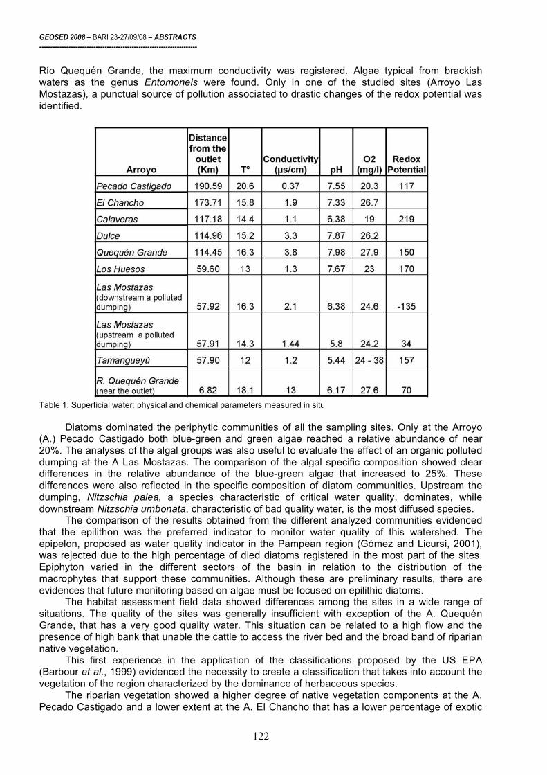
GEOSED 2008 – BARI 23-27/09/08 – ABSTRACTS ----------------------------------------------------------------------
122
Río Quequén Grande, the maximum conductivity was registered. Algae typical from brackish waters as the genus Entomoneis were found. Only in one of the studied sites (Arroyo Las Mostazas), a punctual source of pollution associated to drastic changes of the redox potential was identified.
Table 1: Superficial water: physical and chemical parameters measured in situ
Diatoms dominated the periphytic communities of all the sampling sites. Only at the Arroyo (A.) Pecado Castigado both blue-green and green algae reached a relative abundance of near 20%. The analyses of the algal groups was also useful to evaluate the effect of an organic polluted dumping at the A Las Mostazas. The comparison of the algal specific composition showed clear differences in the relative abundance of the blue-green algae that increased to 25%. These differences were also reflected in the specific composition of diatom communities. Upstream the dumping, Nitzschia palea, a species characteristic of critical water quality, dominates, while downstream Nitzschia umbonata, characteristic of bad quality water, is the most diffused species.
The comparison of the results obtained from the different analyzed communities evidenced that the epilithon was the preferred indicator to monitor water quality of this watershed. The epipelon, proposed as water quality indicator in the Pampean region (Gómez and Licursi, 2001), was rejected due to the high percentage of died diatoms registered in the most part of the sites. Epiphyton varied in the different sectors of the basin in relation to the distribution of the macrophytes that support these communities. Although these are preliminary results, there are evidences that future monitoring based on algae must be focused on epilithic diatoms.
The habitat assessment field data showed differences among the sites in a wide range of situations. The quality of the sites was generally insufficient with exception of the A. Quequén Grande, that has a very good quality water. This situation can be related to a high flow and the presence of high bank that unable the cattle to access the river bed and the broad band of riparian native vegetation.
This first experience in the application of the classifications proposed by the US EPA (Barbour et al., 1999) evidenced the necessity to create a classification that takes into account the vegetation of the region characterized by the dominance of herbaceous species.
The riparian vegetation showed a higher degree of native vegetation components at the A. Pecado Castigado and a lower extent at the A. El Chancho that has a lower percentage of exotic

GEOSED 2008 – BARI 23-27/09/08 – ABSTRACTS ----------------------------------------------------------------------
123
species (Table 2). The first site is also characterized by a higher percentage of grasses and a lower percentage of dicotyledonous species. The presence of weed, exotic species and the increase of dicotyledonous species evidence disturbance, while richness and increase of grasses show a major degree of uncontaminated conditions.
Table 2: Riparian vegetation characterization. Final considerations
In general the preliminary biological results indicate that the monitored rivers have a insufficient water quality possibly related to the diffused pollution due to intensive agricultural activities.
The research requires further investigations, bio-monitoring should be continued and it is foreseen the increasing of monitoring sites. Also, these first results indicate that in the future monitoring can be based on algae. Particularly the analyses should be focused to epilithic diatoms. Macrophytes could also give good information. Acknowledgments This work is funded by the University of Florence (International Cooperation). REFERENCES Barbour, M.T., et al., 1999. Rapid bioassessment protocols for use in stream and wadeable rivers.
Periphyton, benthic macroinvertebrates and fish. Office of Water; 841-B-99-002. U.S. EPA. European Union, 2000. 2000/60/EC Directive of the European Parliament and the Council of 23 October
establishing a framework for Community action in the field of water policy. OJ, L 327 (22.12.2000): 1-72. European Standard EN 13946, 2003. Water quality – Guidance standard for the routine sampling and
pretreatment of benthic diatoms from rivers. European Committee for Standarization, Brussels, 14 pp. Gómez N. and M. Licursi, 2001. The Pampean Diatom Index (IDP) for assessment of rivers and streams in
Argentina. Aquatic Ecology, 35, 173-181. Kelly, M. G. et al., 1998. Recommendations for the routine sampling of diatoms for water quality
assessments in Europe. Journal of Applied Phycology, 10, 215-224. US Army Corps of Engineers, 2002. River Analysis System, User’s manual, Hydrologic Engineering Center. Toja Santillana et al., 2006. Diseño de una red de diatomeas para la cuenca del Río Guadalquivir. Informe
final. Conv. de colab. entre Conf. Hidrográf. del Guadalquivir y el Depto de Biol. Vegetal y Ecología, Univ. de Sevilla.

GEOSED 2008 – BARI 23-27/09/08 – ABSTRACTS ----------------------------------------------------------------------
124
Siliciclastic vs carbonate sedimentation in shallow-marine systems: models of Neogene deltas in the Betic Cordillera
C. Viseras 1 and F. García-García2
1 Departamento de Estratigrafía y Paleontología, Universidad de Granada, Campus de Fuentenueva, s/n.
18071-Granada, Spain 2 Departamento de Geología, Universidad de Jaén, Facultad de Ciencias Experimentales, Campus de Las
Lagunillas, 23071-Jaén, Spain
During the Neogene, sedimentation in the Betic Cordillera took place in two geodinamically different phases. The so called Postorogenic Basins formed during the second phase (starting in the Late Miocene), when the main features of the orogene had already been determined and tectonic activity centred on the convengerce of Africa and Iberia. In this context, the Late Tortonian and Early Pliocene represent the two periods of greatest development of marine deltaic systems.
The complex palaeogeography of the Betic Cordillera during the Late Tortonian, consisting of
marine intramontane basins surrounded by important reliefs and interconnected by narrow corridors, encouraged the development of very coarse-grained delta systems forming on basin margins and often controlled by tectonics. So, in the Granada, Guadix and Tabernas basins delta building took place throughout a fourth-order (< 1 m.a.) transgressive-regressive cycle, consisting of four tectonic systems tracts that include the deltas: a transgressive systems tract controlled by a extensional tectonic regime, a highstand systems tract, a forced-regressive systems tract conditioned by regional tectonic uplift of the central sector of the cordillera and a lowstand systems tract. The regressive phase of the cycle was conditioned by folding and uplift of the source area of the deltas.
During the Early Pliocene marine deltaic sedimentation in the Betic Cordillera was restricted
to the peri-Mediterranean basins flooded by the earliest Pliocene transgression. After this transgressive event the palaeogeography was characterised by different NW-SE oriented gulfs and bays bounded by mountain ranges, basins in which the deltaic systems prograded. Catastrophic sedimentation events (storms and/ or floods) recorded as erosion surfaces, backsets and accumulation layers of oysters and clasts with barnacles on the delta front played an important part in the construction of these deltas.
Palaeogeographic differences in the Tortonian and Pliocene encouraged the development of
alluvial fans as feeder systems of the Tortonian deltas and high energy fluvial systems in the case of the Pliocene deltas. The relative high tectonic subsidence of the basins in the Tortonian in comparison with the Pliocene affected the vertical accumulation of thick deltaic successions (up to 250 m) multiconstructed by several decametric sequences in the Tortonian, whereas the Pliocene deltas mainly developed horizontally.
Shallow-water Gilbert-type deltas predominate, but shoal-water deltas are also recognized
during particular periods of development of the same systems. These changes in the architecture and stratal stacking patterns can be related to the variation in time in accommodation space mainly due to changes in subsidence rates. Therefore, Gilbert-type deltas developed during periods of increase in subsidence rate and shoal-water deltas during periods of decrease in subsidence rate.
In some of the studied examples, towards the top of each delta unit, coral reef patches
overlie the delta plain and are in turn overlain by calcarenites formed by accumulation of branching red algae colonies. Unlike the corals, the branching red algae colonies formed at a very few meters depth under low energy conditions below wave base. The calcarenites derived from branching red algae colonies formed when the delta plain was drowned, creating the new accommodation space needed for the progradation of the delta forming the overlying unit. The repeated alternation of coral reef carbonates (tropical carbonates) and carbonates with bryomol skeletal assemblages

GEOSED 2008 – BARI 23-27/09/08 – ABSTRACTS ----------------------------------------------------------------------
125
(temperate carbonates) in the deltaic successions is linked to relative sea-level changes reflecting the sum of glacio-eustatic sea-level fluctuations and tectonic subsidence.
Fig. 1.- Field aspect and interpretative sketch of one of a Late Tortonian delta system lying against a listric faulted basin margin in the Betic Cordillera

GEOSED 2008 – BARI 23-27/09/08 – ABSTRACTS ----------------------------------------------------------------------
126
Acknowledgments This research was supported by project CGL 2005-06224/BTE financed by the Spanish “Ministry of
Science and Innovation” and the “European Fund of Regional Development” (FEDER) and Research Groups RNM163 and RNM200 of the Junta de Andalucía. REFERENCES Colella, A. and Prior, D.B. (eds.), 1990. Coarse-grained deltas. I.A.S. Spec Publ., 10, 357 p. Dabrio, C.J. and Polo, 1988. Late Neogene fan deltas and associated coral reefs in the Almanzora Basin,
Almería Province, southeastern Spain. In: Fan deltas, Sedimentology and Tectonic Settings (Nemec, W. and Steel, R.J., eds.), 444 p.
García-García, F., Fernández, J., Viseras, C. and Soria, J.M.. 2006a. Architecture and sedimentary facies evolution in a delta stack controlled by fault growth (Betic Cordillera, southern Spain, late Tortonian). Sedimentary Geology, 185, 79-92.
García-García, F., Fernández, J., Viseras, C. and Soria, J.M.. 2006b. High frequency cyclicity in a vertical alternation of Gilbert-type deltas and carbonate bioconstructions in the late Tortonian, Tabernas Basin, Southern Sapain. Sedimentary Geology, 192, 126-139.
Kleverlaan, K., 1989. Three distinctive feeder-lobe systems within one slice of the Tortonian Tabernas fan, SE Spain. Sedimentology, 36, 25-45.
Massari, F. and Parea, G.C., 19990. Wave-dominated Gilbert-type deltas in the hinterland of the Gulf of Taranto (Pleistocene, southern Italy). In: Coarse-grained deltas (Colella, A. and Prior, D.B., eds.). I.A.S. Spec. Publ., 10, 311-331.
Postma, G., 1984. Mass-flow conglomerates in submarine canyon: Abrioja fan-delta, Pliocene, Southeast Spain. In: Sedimentology of Gravels and Conglomerates, (Koster, E.H. and Steel, R.J., eds.), Canadian Society of Petroleum Geologists Memoir, 10, 237-258
Postma, G. and Roep, T.B., 1985. Resedimented conglomerates in the bottomsets of Gilbert-type gravel deltas. Journal of Sedimentary Petrology, 55, 874-885.
Soria, J.M., Fernández, J., García-García, F., and Viseras, C., 2003. Correlative lowstand deltaic and shelf systems in the Guadix Basin (Late Miocene, Betic Cordillera, Spain): the stratigraphic record of forced and normal regressions. Journal of Sedimentary Research, 13, 912-925.
Viseras, C., Soria, J.M., Fernández, J., and García-García, F., 2005. The Neogene-Quaternary basins of the Betic Cordillera: an overview. Geophysical Research Abstracts, 2, 11123-11128.

GEOSED 2008 – BARI 23-27/09/08 – ABSTRACTS ----------------------------------------------------------------------
127
Stratal architecture and evolution of a Pleistocene, coarse-grained submarine canyon fill (Crotone Basin, Southern Italy)
M. Zecchin and M. Caffau
Istituto Nazionale di Oceanografia e di Geofisica Sperimentale – OGS, Borgo Grotta Gigante, 42/c, 34010
Sgonico (TS), Italy [email protected]
The middle Pleistocene Serra Mulara Formation consists of a NW-SE elongated body (4.25 km long and up to 1.5 km wide), laterally confined by a slope clayey and silty succession (the Plio-Pleistocene Cutro Clay Formation) and located behind the modern Neto delta (north of Crotone). The thickness of this succession reaches 195 m.
The first 83 m of the Formation are dominated by gravely to sandy concentrated and hyperconcentrated density flow deposits containing abundant bivalve and gastropod fragments. The 83 – 154 m interval is composed of metre-scale turbidite sequences consisting of sand-mud couplets. Sandy intervals are structureless, planar-laminated and locally rippled, with occasional convolute lamination and slumps. Scour-and-fill and minor channel features were locally observed. This interval passes upward into thicker structureless sands alternated with layers of interlaminated muds and sands containing leaf remains and freshwater ostracods, inferred to represent the product of hyperpycnal flows directly linked to river floods. The upper part of the succession (178 – 195 m) consists of gravely to sandy continental deposits equivalent to those of the middle Pleistocene Cutro Terrace (about 200 ka B.P.).
The Serra Mulara succession, below the upper continental deposits, is interpreted to represent a coarse-grained submarine canyon fill showing an overall fining-upward trend. Facies analysis, together with micropaleontologic data, suggest that the observed features represent a progressive gravel material cut-off during deposition due to a generalized base-level rise and a consequent progressive increasing entrapment of sediment in fluvial to shallow-marine systems. In contrast, in the first accumulation phase, fluvial entry points were close to the canyon head. Later, a base-level lowering is recorded in the upper part of the succession, as shown by both micropaleontologic data and the observed facies.
The Serra Mulara canyon fill is of crucial importance to reconstruct the evolution of this area because it records the late stage accumulation within the Crotone Basin and the subsequent onset of regional uplift in the middle Pleistocene.

GEOSED 2008 – BARI 23-27/09/08 – ABSTRACTS ----------------------------------------------------------------------
128
Partecipanti al Congresso Aiello Gemma - [email protected] Amorosi Alessandro – [email protected] Andreucci Stefano - [email protected] Andriani Gioacchino F. - [email protected] Baldassarre Giuseppe - [email protected] Barchetta Alessia - [email protected] Bertacchini Milena - [email protected] Bertoni Duccio - [email protected] Brandano Marco - [email protected] Cabrera Lluis - [email protected] Cantalamessa Gino - [email protected] Carannante Gabriele - [email protected] Cattaneo Antonio - [email protected] Chiarella Domenico - [email protected] Chieco Michele - [email protected] Ciaranfi Neri - [email protected] Cilumbriello Antonietta - [email protected] Ciociaro Ilaria - [email protected] Cipollari Paola - [email protected] Ciuffreda Biagio Colella Albina - [email protected] Consoloni Ilaria - [email protected] Cosentino Domenico - [email protected] Elisa Costantini - [email protected] D'Atri Anna - [email protected] De Giorgio Giorgio - [email protected] Delle Rose Marco - [email protected]

GEOSED 2008 – BARI 23-27/09/08 – ABSTRACTS ----------------------------------------------------------------------
129
Di Celma Claudio Nicola - [email protected] Di Giorgio Ivan - [email protected] Dimuccio Luca Antonio - [email protected] Di Pinto Giuseppe - [email protected] Felletti Fabrizio - [email protected] Fiore Emanuela - [email protected] Fontana Daniela - [email protected] Gallicchio Salvatore - [email protected] Gamberi Fabiano - [email protected] Giacomelli Serena - [email protected] Grippa Antonio - [email protected] Haq U. Bilal - [email protected] Iaccarino Silvia - [email protected] Iadanza Annalisa - [email protected] La Monica Giovanni Battista - [email protected] Rosanna Laragione - [email protected] Laterza Vittoria - [email protected] Liotta Domenico - [email protected] Lisco Stefania - [email protected] Longhitano Sergio - [email protected] Lugli Stefano - [email protected] Manzi Vinicio - [email protected] Martini Ivan - [email protected] Masucci Ilaria - [email protected] - [email protected] Mecozzi Silvia - [email protected] Moretti Massimo - [email protected] Pascucci Vincenzo - [email protected] Pepe Mariangela - [email protected]

GEOSED 2008 – BARI 23-27/09/08 – ABSTRACTS ----------------------------------------------------------------------
130
Pieri Piero - [email protected] Piovan Silvia - [email protected] Premoli Silva Isabella - [email protected] Roveri Marco - [email protected] Ruberti Daniela – [email protected] Sabato Luisa – [email protected] Sacchi Marco - [email protected] Sandrelli Fabio - [email protected] Sarti Giovanni - [email protected] Simone Lucia - [email protected] Sonnino Maurizio - [email protected] Spalluto Luigi - [email protected] Teruggi Liliana - [email protected] Tinterri Roberto - [email protected] Tropeano Marcello - [email protected] Valletta Salvatore - [email protected] Varrone Dario - [email protected] Vigliotti Marco - [email protected] Viseras César - [email protected] Walsh Nicola - [email protected] Zecchin Massimo - [email protected]