Cogne - enit.de · L’itinerario ha inizio all’estremità nord dell’abitato di Gimillan; segue...
2
CASCATE DI GHIACCIO / GIMILLAN - GRAUSON N° NOME DIFFICOLTÀ 1 SALTA LA GUIDA 3+ 2 L’ULTIMA CHANCE 3 3 CASCATA DI PILA 2+ 4 OCEANO POLARE 3+ 5 GCG 3+ 6 HEI BOE 4 7 SUDORI PRIMAVERIL 2+ CASCATE DI GHIACCIO / VALNONTEY N° NOME DIFFICOLTÀ 1 LAUSON 3 2 INGEGNERIA 3+ 3 THOULE 3+ 4 THOULETTE 4 5 LER 4+ 6 NON FINISCE MAI 2+ 7 CROLLO DI UN MITO 3 8 VALMIANA 3 9 VIVI GULLY 3 10 SENTIERO DEI TROL 3 11 VIVIVOOM 3 12 L’AMOUR RETROUVE’ 5 13 BUON COMPLEANNO 4+ 14 THE DESPERATION’S SEVEN M5 - dry tooling 15 IL FRENO A MANO M7 - dry tooling 16 SOGNO DI PATAGONIA 5+ 17 BENEDETTO VIRUS 3 18 GRAN VAL 3+ 19 MILLENIUM BAG 5 20 DAIKIRI 5 21 PER UN AMICO 4+ 22 ERFOLET 5 23 GHOST GULLY 3+ 24 DI FRONTE AL TRADIMENTO 5+ 25 SOGNO DI UNO GNOMO 4+ 26 SOGNO IBERNANTE 5 27 DEDICA PER SARA 2+ 28 VOGLIA EFFIMERE 4+ 29 VOGLIA DI TENEREZZA 3 30 SWEET VALENTINA 3+ 31 RASSEGNAZIONE 3 32 PAZIENZA 2 33 COUPE’ MONEY 3+ 34 MISTIRIA 3 35 FALLO DI PLUTONE 3+ 36 FIUMANA DI MONEY 2+ 37 FLASH ESTIVO 3 38 COLONNATO CENTRALE 3+ 39 MONDAY MONEY 4+ 40 REPENTANCE SUPER 6 41 AGO DI MONEY 4+ 42 ACHERONTE 3+ 43 PUGLIA HOLIDAY 5+/M8-dry tooling 44 PAPI E MAMI 4+ 45 CANDELONE DI PATRI 5 46 PATRI CLASSICA 4 47 CHANDELLE CHAMONIX 5 48 ERA GLACIALE 4 49 ERA MIO PADRE 4 50 SENTINEL ICE 5+ 51 CICCIU GALUCCIU 5 52 DOCCIA FREDDA 5 53 LA FAVOLA DI ALICE M7 - dry tooling CASCATE DI GHIACCIO / LILLAZ - VALEILLE N° NOME DIFFICOLTÀ 1 TUBORG 4 2 CANDELABRO DEL COYOTE 4+ 3 IL MISTOMANE 4 4 CHANDELLE LEVURE 4 5 FENILIA 2 6 PASSEPARTOUT 2 7 LE CIGARE 5 8 PER UN AMICO 4+ 9 VERTIGINE DI PORCELLANA 3 10 HENNINGER 4 11 TRAFFIC 4+ 12 GRAN VAL 3+ 13 VELLO DI CINGHIALE 3 14 PAGINE DI GLORIA 3 15 ISABELLA 3 16 GIANDUIOTTO BY NIGHT 2 17 PARERI CONTRASTANTI 3+ 18 LA RISPOSTA 4 19 L’INCONNU 4 20 AZZAVATTA 4+ 21 ANICK 4+ 22 ATHINA 4 23 EQUILIBRI SOLARI 4 24 SOTTIGLIEZZE VETRATE 3+ 25 COCO CHANEL 4 26 ECKNATON 5 27 ALLA RICERCA DELL’INUTILE 5 28 BALTICA 4 29 BUDELLO DI MAMBO 4 30 MANI DI FATA 5 31 ALA DI GELO 4 32 SUDORI FREDDI 5+ 33 FRIGIDA 3 34 RICOMINCIO DA CENTO 3 35 DAI CHE CE LA FAI 2 36 LA STORIA FINITA 2 37 LA CLESSIDRA DEI CELSIUS 3 38 ARTAX 4+ 39 AYVIE DZALAIE 2 40 100 GELATO DI STAGIONE 2 41 CHANDELLE MONIQUE 4+ 42 80a FOLGORAZIONE 89 5 43 IL GRANDE CALIMERO 4 44 GRAZIE ALBINO 2 45 PICCOLA LELLA 2 46 AROLLA 2 47 ARIAN 4+ 48 LES PIOLETS DISPARUS 2 49 SUNRISE 5+ 50 ATTACCO DIRETTO 5+ 51 ETOILE ET SOLEIL 5 52 SALSA DU SOLEIL M8 - dry tooling 53 DOPPIO RUM 5 / M7+ dry tooling 54 GIGOLO A CHEDE 4+ / M6 - dry tooling 55 COLD COULOIR 4+ 56 ILHAO FELIX 5+ 57 A LA MEMOIRE DU BOUQUETIN 5+ 58 JEDI MASTER M11 - dry tooling 59 THE EMPIRE STRIKES BACK M9+ - dry tooling 60 INACHEVEE CONCEPTION 5+ 61 LES INVASIONS BARBARES M6 - dry tooling 62 STELLA ARTICE 5 63 GELATI M8 - dry tooling 64 RIACAMO 5+ 65 HARD ICE IN THE ROCK 4 66 ATTACCO DIRETTO 6 67 TWIN PEAKS M9 - dry tooling 68 X FILE M9 - dry tooling 69 PATTINAGGIO ARTISTICO 3 70 PANACHE ON THE ROCK M6+ - dry tooling 71 LES COCHONS DANS L’ESPACE M7 - dry tooling 72 ATTACCO DIRETTO 5+ 73 SOSPIRI IBERNATI 4+ 74 NEGATIVE FEELING 4 75 TUTTO RELATIVO 4 76 CRISTAL GIUSI 3 77 EAU DES CRISTAUX 4 78 GHIACCIATORI DEL SUD 4+ 79 SPADA NELLA ROCCIA 5 80 STALATTITE DI CRISTALLO 5 81 LILLAZ GULLY 4 82 CHANDELLE IBEX 5 83 IBEX GULLY 4 84 LOIE 3 85 PRIMA 2 86 EDELWEISS M6 - dry tooling 87 MEDUSA M6 - dry tooling 88 LAU BIJ 5+ 89 LILLAZ 3+ CASCATE DI GHIACCIO / MOLINE N° NOME DIFFICOLTÀ 1 PETIT ROUGE M4 dry tooling 2 APERITIVO M2 dry tooling 3 CABERNET SAUVIGNON 3 4 SAUVIGNON BLANC 3+ 5 RIOJA M4+ dry tooling 6 MERLOT M4+ dry tooling 7 SHIRA M5+ dry tooling 8 UNO MEDIA BIRRA 3 9 DUE MEDIA BIRRA 3 10 GRANDE BIRRA 3 11 TRE MEDIA BIRRA 3 12 QUATTRO MEDIA BIRRA 3 13 SUB CULTURE M6 dry tooling 14 BASS GENERATOR M6 dry tooling 15 POWER BAND M6 dry tooling 16 TECHNO HEAD M5 dry tooling 17 BIG COUNTRY DREAMS 3+ 18 COME DANCING 2 19 ULTIME CARTUCCE 2 partenza départ start Start difficile difficile difficult schwer media moyenne medium durchschnittlich facile facile easy Leicht Foyer de fond Langlauf - Foyer Segnaletica: tabelloni Partenza/Arrivo, segnala- zione ai bivi, frecce indicatrici il senso di marcia Battitura: binario Classico e Skating Apertura piste: dicembre/marzo Orario di apertura: 9.00 - 17.00 Soccorso piste: tel. 0165.74008 servizio emergenza 118 Il regolamento della pista, approvato con deliberazione del Consiglio Comunale n. 61 in data 27/11/97, è esposto presso i punti vendita dei biglietti. Balisage : panneaux géants Départ/Arrivée, balisage aux bifurcations, flèches d’indication du sens de marche. Battage : rails classiques et skating Ouverture des pistes : de décembre à mars Horaires d’ouverture : 9h00 - 17h00 Secours sur piste : tél. 0165 74008 service d’urgence 118. Approuvé par délibération du Conseil communal n° 61 du 27/11/1997, le règlement des pistes est exposé dans chaque point de vente des billets. Markings: Start/Finish boards, junction signs, arrows marking direction. Grooming: Classic skiing and skate skiing Trails open: December/March Opening times: 9.00 - 17.00 Trail rescue: tel. 0165.74008 emergency service 118 Trail regulations, approved by Town Council law n.61 dated 27 November 1997, are displayed at all ticket sales points. Beschilderung: Tafeln Start/Ziel, Schilder an den Kreuzungen, Pfeile, die die Fahrtrichtung angeben. Art der Loipe: Klassisch und Skating Öffnungszeiten: 9.00h - 17.00h Erste Hilfe: Tel.0165-74008 - Notruf 118 Die Pistenbestimmungen, genehmigt nach dem Gemeinde- ratsbeschluss Nr.61 vom 27.November 1997, hängen bei den Kartenverkaufsstellen aus. DECALOGO DEL FONDISTA REGLES FONDAMENTALES DU SKIEUR DE FOND CROSS-COUNTRY SKIING MEMO VORSCHRIFTEN FÜR DEN LANGLÄUFER 1. Rispetto degli altri. Ogni fondista non deve mettere in pericolo gli altri sciatori, specie i principianti. Respect d’autrui - Tout skieur de fond ne doit pas mettre en danger les autres skieurs et, plus parti- culièrement, les débutants. Respect others. No cross-country skier must put other skiers in danger, especially beginners. Rücksichtnahme Dritter gegenüber: Kein Langläufer darf die anderen in Gefahr bringen, vorallem nicht die Anfänger. 2. Rispetto segnaletica. E’ necessario rispettare palinature e segnaletica, seguire il senso di marcia. Respect du balisage - Il est nécessaire de respecter: les indications des piquets, la signalétique, le sens de marche. Respect signs. You must respect the marking poles and signs, follow the indicated direction. Beachtung der Beschilderung: Man muss die Pistenabsteckungen und Beschilderungen beachten und der Fahrtrichtung folgen. 3. Traccia da seguire. Percorrere sempre la traccia di destra. I gruppi devono procedere in fila indiana. Tracé à suivre - Suivre toujours le tracé de droite. Les groupes doivent avancer en file indienne. Tracks to follow. Always use the right-hand tracks. Groups must proceed in single file. Spur einhalten: Man muss immer auf der rechten Spur fahren. Gruppen müssen hintereinander fahren. 4. Tipo di sciata. Chi utilizza il pattinaggio non deve danneggiare la traccia della tecnica classica per l’alternato. Style employé - Qui choisit le patinage ne doit pas endommager le tracé de la technique classique du pas alterné. Skiing style. Skaters must not damage the classic skiing tracks. Langlaufart: Wer im Schlittschuhschritt fährt darf die Loipenspur des klassischen Stils nicht beschädigen. 5. Sorpasso. Gli sciatori sono tenuti a cedere il passo al fondista più veloce. Dépassement - Les skieurs doivent céder le pas aux plus rapides. Overtaking. Skiers are obliged to let faster skiers overtake. Überholen: Die Langläufer müssen die schnelleren Langläufer vorbei lassen. 6. Sosta e caduta. La sosta va effettuata fuori dai binari. In caso di caduta, lasciare immediatamente libera la pista. Halte et chute - Les haltes doivent être effectuées hors des rails. En cas de chute, libérer immédiatement la piste. Stops and falls. Stop off the tracks. When falling, leave the tracks free as soon as possible. Rast und Sturz: Hält man an oder fällt man hin muss man die Loipe sofort frei machen. 7. Gara in corso. Durante la gara non intralciare la pista. Compétition en cours - Ne pas entraver la piste en cours de compétition. Race taking place. When a race is taking place do not obstruct the tracks. Skirennen: Während eines Skirennens darf man die Loipe nicht befahren. 8. Velocità. Il fondista deve adattare la velocità alle sue capacità tecniche. Vitesse - Le skieur doit adapter sa vitesse à ses capacités techniques. Speed. Cross-country skiers must ski at a speed suited to their ability. Geschwindigkeit: Der Langläufer muss die Geschwindigkeit seinen technischen Fähigkeiten anpassen. 9. Distanza di sicurezza. Mantenere la distanza di sicurezza dal fondista che precede. Distance de sécurité - Maintenir une distance de sécurité entre le skieur qui précède. Safety distance. Keep a safe distance from the skier in front of you. Sicherheitsabstand: Der Sicherheitsabstand zu dem vorigen Langläufer muss eingehalten werden. 10. Rispetto. Non abbandonare rifiuti; non dan- neggiare la natura. Non rovinare la traccia cammi- nando a piedi, utilizzando slitte o sci da discesa. Respect - Ne pas abandonner d’ordures, ne pas endommager la nature. Ne pas abîmer le tracé en marchant à pied, en luge ou avec les skis alpins. Respect. Do not leave litter; do not damage na- ture. Do not ruin the tracks by walking on them, using sledges or downhill skis. Respekt: Keine Abfälle liegen lassen. Die Natur nicht verschmutzen. Die Loipen nicht beschädigen, indem man sie zu Fuss, mit Schlitten oder alpinen Skiern begeht. ITINERARI INVERNALI PER PEDONI O CON LE RACCHETTE DA NEVE Accanto alla pratica dello sci, ecco alcuni interessanti itinerari battuti sulla neve per vivere preziosi momenti di serenità … I percorsi proposti si prestano per facili camminate a piedi o con le racchette da neve e rappresentano una piacevole op- portunità per passeggiare nell’incanto della natura invernale, alla scoperta delle splendide bellezze del Parco Nazionale del Gran Paradiso. Segnaletica: cartelli gialli. 1 - SERVE Tempo di percorrenza dell’anello: 1,30 h. Dislivello: 212 m. Percorso facile, privo di pericoli e molto soleggiato che alterna tratti nel bosco e passaggi straordinariamente panoramici. L’itinerario ha inizio all’estremità nord dell’abitato di Gimillan; segue per qualche centinaio di metri la strada poderale che sale a tornanti e prosegue, quindi, in piano verso sinistra fino in loc. Serve. Un largo sentiero immette nel bosco e, con un ampio tornante, conduce ad una radura in direzione Gimillan. In breve, con ampi panorami sulla catena del Gran Paradiso e sulla Grivola, si arriva al punto di partenza. 2 - TOR DE MOUGNE Tempo di percorrenza dell’andata: 1 h. per Cogne - 1,15 h. per Gimillan Dislivello: 64 m. / Cogne - 318 m. / Gimillan Itinerario facile che collega la Fraz. Epinel a Cogne o Gimillan. Partendo nella parte alta della frazione Epinel (1.470 mt), se- guendo un breve tratto di poderale, si raggiunge il rudere della “Tor de Mougne”. Proseguendo a sinistra in leggera salita, attraversato il sottopasso ferroviario, si giunge ad un bivio dove, svoltando a destra, si scende verso il distributore di car- buranti. Procedendo lungo la strada comunale che attraversa l’abitato di Cretaz ci si immette nella parte bassa dell’itinera- rio 3-Sant’Orso che raggiunge il centro di Cogne. Dal medesimo bivio, dopo il sottopasso ferroviario, è possibile, svoltando a sinistra, seguire un tracciato che, tra boschi di pino silvestre e panorami incantevoli sulla vallata di Cogne e sul massic- cio del Gran Paradiso, sale fino alla frazione di Gimillan e si collega all’itinerario 1-Serve. 3 - SANT’ORSO Tempo di percorrenza dell’anello: 1,15 h. Dislivello: 75 m. Itinerario molto facile ad anello che si sviluppa quasi interamente sui prati di Sant’Orso. Rilassante ed interessante per co- loro che desiderano ammirare i fondisti in allenamento sulle innumerevoli piste di fondo. Partenza possibile da Cogne, da Cretaz o da Son-le-Prò. Il tracciato costeggia l’abitato di Cogne formando una mezza luna. Raggiunta la parte più alta, si per- corre un breve tratto di strada carrozzabile, poi si scende sulla destra orografica del torrente Valnontey sino all’altezza del ponte di Buthier. Superato il ponte, la passeggiata continua sulla sinistra orografica fino all’abitato di Cretaz rientrando, quindi, verso Cogne. L’itinerario può essere percorso nei due sensi di marcia. 4/5 - IL BOSCO INCANTATO Tempo di percorrenza dell’anello: 1,30 h. Dislivello: 133 m. Percorso ad anello nei pressi del capoluogo effettuabile con ogni condizione meteo e ideale per chi sa apprezzare i parti- colari della natura. Dal centro del paese di Cogne proseguire sulla strada comunale direzione Lillaz fino all’altezza del ri- storante “Lou Ressignon”. Sulla destra imboccare la strada in salita che passa vicino alla casa del P.N.G.P. per poi proseguire sino allo “Stambeccaggio” (Centro Studi Fauna Alpina). Proseguendo si giunge ad un bivio dove inizia l’anello che può es- sere percorso nei due sensi di marcia (un tratto dell’anello è percorribile solo con le racchette da neve, vedi cartina). Il trac- ciato si sviluppa nell’incantato bosco di “Sylvenoire” con saliscendi e curve in mezzo a mille forme create da sassi, piante e cristalli. Bar-ristorante raggiungibile solo con le racchette. 6 - CASCATE DI LILLAZ Tempo di percorrenza dell’andata: 1,00 h. Dislivello: 90 m. Itinerario che collega Cogne alle cascate di Lillaz. Il primo tratto ripercorre l’itinerario 4-Il bosco incantato. All’uscita del bosco di “Sylvenoire” si prosegue in discesa verso l’abitato di Champlong. Attraversato il ponte si continua sul marciapiede della strada comunale sulla destra orografica del torrente Urtier. Attraversato l’abitato di Lillaz, seguendo le indicazioni, si prosegue verso le cascate omonime che in inverno diventano uno spettacolare palcoscenico su cui numerosi “cascatisti” si cimentano. Dall’abitato di Lillaz è inoltre possibile proseguire, costeggiando i due campeggi, lungo il sentiero che a tor- nanti sale al ponte di Tzéleret. Vista sulla vallata selvaggia della Valeille e sui suoi ghiacciai. 7 - URTIER Tempo di percorrenza dell’andata: 1,30 h. Dislivello: 239 m. Prima dell’abitato di Lillaz, sulla sinistra, imboccare la strada poderale che, salendo a lunghi tornanti verso il vallone dell’Urtier, porta all’antico villaggio di “Les Goilles” (1.856 mt.). Itinerario particolarmente soleggiato con spettacolare vista sulla Va- leille e con i suoi ghiacciai e sull’esteso vallone dell’Urtier. 8 - PANORAMICA DEL MONTSEUC Tempo di percorrenza dell’andata: 30 min. Dislivello: 119 m. Escursione in alta quota con favoloso panorama sulla catena del Gran Paradiso e su tutta la valle di Cogne. La passeggiata stimola una forte sensazione di avvicinamento e contatto con i ghiacciai circostanti. Dalla parte alta dell’abitato di Cogne, prendere la Telecabina pulsé del Montseuc che porta a quota 2.081 mt. All’arrivo salire fino allo chalet bar e imboccare a destra il sentiero che, in leggera pendenza, superato un ponticello di legno su un ripido canalone, porta allo spazio del Bel- vedere a 2.100 mt. Da questo punto, proseguendo a sinistra in salita in mezzo ad alberi secolari, si giunge ad una de- pressione panoramica a 2.200 mt. Il ritorno si effettua sullo stesso percorso. 9 - GRAN PARADISO Tempo di percorrenza dell’andata: 1,00 h. Dislivello: 64 m. Gita varia ed interessante all’interno del Parco Nazionale del Gran Paradiso con possibilità d’imbattersi in branchi di camo- sci e stambecchi. Spettacolare vista sul massiccio del Gran Paradiso e sui suoi imponenti ghiacciai. Si potranno osservare gli alpinisti provenienti da ogni parte del mondo intenti ad arrampicarsi sulle innumerevoli cascate di ghiaccio. Dalla frazione Valnontey proseguire sulla destra orografica del torrente omonimo fino ai casolari dell’alpe Vermiana (1.731 mt). Il ritorno si effettua sullo stesso percorso. 10 - PIAN DELLA CRETETTA Tempo di percorrenza dell’anello: 1,30 h. Dislivello: 215 m. Incantevole itinerario ad anello da affrontare solo con racchette da neve che ha inizio a nord ovest della frazione di Gimil- lan. Superato il ponticello in legno proseguire verso nord inoltrandosi nel bellissimo vallone del Grauson. Il percorso prose- gue rientrando verso il Pian della Cretetta, un suggestivo pianoro a 2000 metri circondato da una pineta. Ricordiamo agli escursionisti che è severamente vietato camminare sulle piste di sci. ITINERAIRES POUR PIETONS OU POUR RANDONNEES EN RAQUETTES Á NEIGE En supplément à la pratique du ski, voici quelques suggestifs itinéraires tracés dans la neige qui vous permettront de vivre de précieux moments de sérénité… Les parcours proposés sont adaptés à des randonnées à pied ou en raquettes à neige et représentent une agréable occasion de promenade, environné par la magie de la nature hivernale et à la découverte des splendides beautés du Parc National du Grand Paradis. Balisage: panneaux jaunes. 1 - SERVE Durée : 1,30 h. Dénivellement : 212 m. Parcours facile, sans danger et particulièrement ensoleillé, alternant des passages en forêt et des panoramas extraordi- naires. Le départ est situé à l’extrême nord de Gimillan ; on suit sur quelques centaines de mètres le chemin rural qui monte en lacets et on continue ensuite en terrain plat, sur la gauche, jusqu’au hameau Serve. Un large sentier s’engouffre dans le bois et, par un ample virage, mène à une clairière en direction de Gimillan. Face à d’amples panoramas sur la chaîne du Grand Paradis et sur la Grivola, on revient très vite au point de départ. 2 - TOR DE MOUGNE Durée : 1,00 h. pour Cogne - 1,15 h. pour Gimillan Dénivellement : 64 mt / Cogne - 318 mt / Gimillan Un itinéraire facile, qui relie le hameau Epinel à Cogne, le chef-lieu. Partir de la partie haute du hameau Epinel (1 470 m) et suivre un bref parcours sur le chemin rural ; on arrive ainsi aux ruines d’une ancienne tour appelée " Tor de Mougne ". Con- tinuer ensuite en montant légèrement sur la gauche et, après avoir traversé le passage souterrain du chemin de fer, on ar- rive à une bifurcation d’où, en prenant à droite, on descend vers la pompe à essence. Continuer le long de la route communale qui traverse Cretaz et s’engager dans la partie basse de l’itinéraire n° 3 - Saint-Ours qui atteint le centre de Cogne. Après le passage souterrain du chemin de fer, et à la même bifurcation, on peut aussi suivre, en tournant à gauche, un autre parcours qui, par le bois de pins sylvestres et face à des panoramas enchanteurs sur la vallée de Cogne et le mas- sif du Grand Paradis, monte jusqu’au hameau de Gimillan et nous relie à l’itinéraire n° 1 - Serve. 3 - SAINT-OURS Durée : 1,15 h Dénivellement : 75 m. Itinéraire en boucle, d’une grande facilité, qui se déroule presque entièrement sur les prés de Saint-Ours. C’est aussi un itinéraire relaxant et présentant un grand intérêt pour tous ceux qui aiment suivre les skieurs de fond à l’entraînement sur les innombrables pistes de fond. On peut partir, au choix, de Cogne, de Cretaz ou de Son-le-Prò. Le tracé suit le centre habité de Cogne en for- mant une demi-lune. Une fois arrivé à la partie la plus haute, suivre un bref trajet de route goudronnée puis descendre, sur la droite orographique du torrent Valnontey, jusqu’à la hauteur du pont sur le Buthier. Après le pont, la promenade continue sur la gauche orographique, jusqu’aux habitations de Cretaz, rentrant ainsi jusqu’à Cogne. Cet itinéraire peut être suivi dans les deux sens. 4/5 - LE BOIS ENCHANTE Durée : 1,30 h Dénivellement : 133 m. Parcours en boucle dans les environs du chef-lieu, praticable par toute condition météorologique et idéal pour qui sait apprécier les particularités naturelles. A partir du centre de Cogne, suivre la route communale en direction de Lillaz, jusqu’à la hauteur du restaurant "Lou Ressignon". Prendre sur la droite la route qui monte en passant près de la maison du P.N.G.P. et poursuivre ju- squ’au "Stambeccaggio" (Centre d’Etude de la Faune Alpine). En continuant, on arrive à une bifurcation d’où part l’anneau pou- vant être parcouru dans les deux sens (une partie de l’itinéraire est parcourible seulement en raquettes à neige - voir le plan). Le tracé parcours le bois enchanté de Sylvenoire où s’alternent montées et descentes, virages, parmi des milliers de formes créées par les rochers, les plantes et les cristaux. L’acces au bar-restaurant est possible seulement en raquettes à neige. 6 - LES CASCADES DE LILLAZ Durée : 1,00 h Dénivellement : 90 m. Un itinéraire qui relie Cogne aux cascades de Lillaz. La première partie reprend l’itinéraire n° 4 - Le bois enchanté. A la fin du bois de Sylvenoire, continuer en descendant vers le hameau Champlong. Après avoir traversé le pont, continuer sur le trottoir de la route communale, sur la droite orographique du torrent Urtier. Après avoir traversé Lillaz, continuer, suivant les indications, vers les cascades du même nom qui, en hiver, se transforment en une scénographie spectaculaire où de nombreux amateurs d’escalades mettent à l’épreuve leurs talents. A partir de Lillaz, on peut aussi continuer, en longeant les deux campings, le long du sentier qui monte en lacets jusqu’au pont de Tzéleret d’où l’on peut admirer le panorama sur la vallée sauvage de la Valeille et ses glaciers. 7 - URTIER Durée : 1,30 h Dénivellement : 239 m. Avant d’arriver à Lillaz, prendre sur la gauche le chemin rural qui, par de larges tournants en direction du vallon de l’Urtier, mène à l’ancien village dénommé " Les Goilles " (1 856 m). Cet itinéraire est particulièrement exposé au soleil avec une vue spectaculaire sur la Valeille et ses glaciers et sur le vallon étendu de l’Urtier. 8 - PANORAMIQUE DU MONTSEUC Durée : 0,30 h Dénivellement : 119 m. Excursion en haute altitude offrant un fabuleux panorama sur la chaîne du Grand Paradis et toute la vallée de Cogne. L’ex- cursion stimule une forte sensation de rapprochement et de contact avec les glaciers alentours. Partant de la partie haute de Cogne, prendre la télécabine " Pulsé du Montseuc " qui vous amène à 2 081 m. A l’arrivée, monter jusqu’au chalet-bar et prendre à droite le sentier qui, en douceur, et après avoir dépassé un petit pont de bois jeté sur un raide couloir, débouche sur l’esplanade du Belvédère à 2 100 m. D’ici, en continuant sur la gauche et en montant parmi les arbres centenaires, on arrive à une dépression panoramique à 2 200 m. Même parcours au retour. 9 - GRAND PARADIS Durée : 1,00 h Dénivellement : 64 m. Excursion présentant divers intérêts au sein du Parc National du Grand Paradis, offrant la possibilité de rencontrer des har- des de chamois et de bouquetins. Spectaculaire panorama sur le massif du Grand Paradis et ses glaciers imposants. On peut aussi y observer des alpinistes venant de toute part, s’entraînant à escalader les nombreuses cascades de glace. Du hameau Valnontey, continuer sur la droite orographique du torrent du même nom jusqu’aux habitations de l’alpage de Ver- miana (1 731 m). Même parcours au retour. 10 - PIAN DELLA CRETETTA Durée : 1,30 h. Dénivellement : 215 m. Joli itinéraire en boucle, à affronter seulement avec les raquettes à neige, qui commence au nord-ouest du hameau de Gi- millan. Passé le petit pont en bois, continuez vers le nord en pénétrant dans le magnifique vallon du Grauson. Le circuit con- tinue avec retour sur le Pian della Cretetta, un plateau suggestif entouré d'une pinède à 2000 mètres d’altitude. Rappelons aux excursionnistes qu’il est formellement interdit de marcher sur les pistes de ski. WINTERWANDERWEGE ZU FUSS ODER MIT SCHNEESCHUHEN Neben den Skipisten gibt es auch einige interessante Wanderwege zu Fuss oder mit Schneeschuhen, die entspannende Momente in einer herrlichen Winterlandschaft bieten..... Die vorgeschlagenen Strecken sind geeignet für einfache Wan- derungen zu Fuss oder mit Schneeschuhen und ermöglichen die Schönheit des Nationalparks Gran Paradiso zu entdec- ken. Beschilderung: plakat gelb. 1 SERVE Dauer: 1,30 h. Höhenunterschied: 212 m. Einfacher, ungefährlicher und sonniger Weg, der durch Wälder führt und Abschnitte mit herrlichem Panorama bietet. Die Strecke beginnt ganz im Norden des Ortsteils Gimillan; führt einige hundert Meter einem Schotterweg entlang, steigt dann in Kurven an und führt nach links in den Ortsteil Serve. Ein breiter Weg führt in den Wald und in einer weiten Kurve zu einer Lichtung in Richtung Gimillan. Kurz darauf erreicht man den Ausgangspunkt immer mit Blick auf die Kette des Gran Paradiso und den Grivola. 2 TOR DE MOUGNE Dauer: 1 h. Cogne - 1,15 h. Gimillan Höhenunterschied: 64 mt / Cogne - 318 mt / Gimillan Eine einfache Strecke die Epinel mit Cogne verbindet. Oberhalb des Ortsteils Epinel beginnend (1470m), über ein kurzes Stück Schotterweg, kommt man zu den Überresten des „Tor de Mougne“. Weiter nach links leicht bergaufwärts, kommt man durch eine Eisenbahnunterführung an eine Kreuzung, an der man nach rechts abbiegt und auf eine Tankstelle stösst. Auf der Gemeindestrasse, die durch den Ortsteil Cretaz führt, gelangt man dann auf die Strecke 3-SANT’ORSO, die in das Zentrum von Cogne führt. An der obengenannten Kreuzung nach der Eisenbahnunterführung kann man auch nach links abbiegen und kommt so auf einen Weg mit herrlichem Blick auf das Tal von Cogne und das Massiv des Gran Paradiso. Durch Kiefernwälder gelangt man zu dem Ortsteil Gimillan und dann auf die Strecke 1 SERVE. 3 SANT’ORSO Dauer: 1,15 h. Höhenunterschied: 75 m. Ein sehr einfacher Rundweg, der sich praktisch komplett auf den Wiesen von Sant’Orso entlang schlängelt. Entspannend und interessant für diejenigen, die gerne den Langläufern bei ihrem Training auf den zahlreichen Loipen zuschauen. Mögli- che Ausgangspunkte sind Cogne, Cretaz oder Son-le Prò. Die Strecke führt in einem Art Halbmond an dem Ort Cogne vor- bei. Oben angekommen geht man ein kurzes Stück auf einem Trampelpfad, der dann rechts flussabwärts am Fluss Valnontey entlang, bis auf Höhe der Brücke des Buthier führt. Hat man die Brücke überquert, führt der Spaziergang links flussabwärts bis zu der Ortschaft Cretaz und schliesslich in Richtung Cogne. Diese Strecke kann man in beide Richtungen begehen. 4/5 IL BOSCO INCANTATO ( der Zauberwald) Dauer: 1,30 h. Höhenunterschied: 133 m. Ein Rundweg in der Nähe des Hauptortes, bei jeder Witterung zu begehen und geeignet für diejenigen, die die Natur be- sonders schätzen. Vom Ortszentrum von Cogne aus, folgt man der Gemeindestrasse in Richtung Lillaz bis auf Höhe des Restaurants „Lou Ressignon“. Man biegt nun rechts in die Strasse ein, die bergauf an der Parkwächterhütte (P.N.G.P.) vor- bei bis zum „Stambeccaggio“ (Studienzentrum der alpinen Fauna) führt. Weiter kommt man an eine Kreuzung, an der der Rundweg beginnt, den man in beide Richtungen begehen kann (Teil von der Rundweg ist für Schneeschuhen nur). Die Strecke führt durch den märchenhaften Wald von „Sylvenoire“, der in einem Auf und Ab von Serpentinen an Tausenden von bizarren Formen aus Steinen, Pflanzen und Kristallen vorbei führt. Erreichbare Bar-Verpflegung mit Schneeschuhen nur. 6 DIE WASSERFÄLLE VON LILLAZ Dauer: 1,00 h. Höhenunterschied: 90 m. Die Strecke verbindet Cogne mit den Wasserfällen von Lillaz. Der erste Abschnitt verläuft auf der Strecke 4 DER ZAU- BERWALD. Kommt man aus dem Wald „Sylvenoire“ heraus, geht man weiter abwärts in Richtung der Ortschaft Champlong. Nach der Brücke geht man auf dem Gehweg der Gemeindestrasse auf der rechten Seite des Urtier flussabwärts weiter. Hinter der Ortschaft Lillaz folgt man der Beschilderung in Richtung der gleichnamigen Wasserfälle, die im Winter ein büh- nenreifes Spektakel bieten, und auf denen sich zahlreiche „Eisfallkletterer“ üben. Von Lillaz aus kann man auch auf einem Weg weitergehen, der entlang der zwei Campingplätze, in Serpentinen zu der Brücke von Tzéleret führt. Aussicht über das Tal des Valeille und seinen Gletschern. 7 URTIER Dauer: 1,30 h. Höhenunterschied: 239 m. Vor der Ortschaft Lillaz, linker Hand, biegt man in den Schotterweg ein, der über langgezogene Kurven über das Hochtal des Urtier zu dem antiken Ort „Les Goilles“ (1856m) führt. Die Strecke liegt auf der Sonnenseite und bietet eine spekta- kuläre Aussicht auf den Valeille mit seinen Gletschern und das Hochtal des Urtier. 8 PANORAMASTRASSE DES MONTSEUC Dauer: 0,30 h. Höhenunterschied: 119 m. Ausflug im Hochgebirge mit herrlichem Panorama auf die Kette des Gran Paradiso und das ganze Tal von Cogne. Auf die- ser Wanderung hat man das Gefühl den umliegenden Gletschern ganz nah zu sein. Oberhalb von Cogne nimmt man die Seilbahn Pulsé Montseuc, die auf 2.081m führt. An der Bergstation steigt man bis zu der Chalet Bar an und biegt nach rechts in den Weg ein, der in leichtem Gefälle über eine kleine Holzbrücke und weiter auf den Aussichtspunkt Belvedere auf 2.100m führt. Von hier aus geht man weiter nach links in mitten von jahrhundertealten Bäumen und kommt zu einer Senke auf 2.200m mit herrlichem Ausblick. Der Rückweg verläuft auf der gleichen Strecke. 9 GRAN PARADISO Dauer: 1,00 h. Höhenunterschied: 64 m. Eine abwechslungsreiche und interessante Wanderung im Nationalpark des Gran Paradiso bei der es möglich ist auf Gem- sen und Steinböcke zu treffen. Herrliche Aussicht auf das Massiv des Gran Paradiso und seine gewaltigen Gletscher. Man kann Bergsteiger aus der ganzen Welt beobachten, die sich im Klettern auf den unzähligen Eisfällen üben. Von dem Or- tsteil Valnontey aus geht man flussabwärts auf der rechten Seite des gleichnamigen Flusses bis zu den Hütten der Alm Vermiana (1731m). Der Rückweg verläuft auf der gleichen Strecke. 10 PIAN DELLA CRETETTA Dauer: 1,30 h. Höhenunterschied: 215 m. Ein Ring durch eine malerische Landschaft, der ausschließlich mit Schneestöcken zurückgelegt werden sollte. Er beginnt nordwestlich des Ortes Gimillan. Hinter der kleinen Holzbrücke geht es Richtung Norden in das herrliche Grauson Tal und dann weiter in Richtung Pian della Cretetta, eine malerische, von einem Wald umgebene Hochebene in 2000 m Höhe. Wir erinnern hiermit die Wanderer, dass es strengstens verboten ist die Skipisten zu Fuss zu begehen. pista difficile difficulté : difficile difficult slope schwer pista media difficulté : moyenne medium slope Schwierigkeitsgrad durchschnittlich pista facile difficulté : facile easy slope Schwierigkeitsgrad leicht Telecabina Pulsé Montseuc (m. 1588 - 2060) Télécabine Pulsé Montseuc Pulsé Montseuc Cablecar Seilbahn Pulsé Montseuc Seggiovia Sylvenoire (m. 1588 - 1705) Télésiège Sylvenoire Sylvenoire chair lift Sessellift Sylvenoire Seggiovia Bois du Sylvenoire - Crou du Montseuc (m. 1961 - 2296) Télésiège Bois du Sylvenoire Bois du Syl- venoire Chair Lift Sessellift Bois du Sylvenoire Parco Giochi Cogne Parc à jeux de Cogne Cogne Snowpark Spielplatz Cogne Bar ristori sulle piste - Deposito sci alla partenza degli impianti - Brevi attese agli impianti di risalita - Organizzazione di gare sociali con cronometraggio elettronico e tabellone per il pubblico - Servizio ski-bus gratuito. Bar-restauration sur les pistes - Dépôt des skis au départ des installations de remonte-pente - Brefs temps d’attente aux installations de remonte-pente - Organisation de compétitions sociales avec chronométrage électronique et panneaux gé- ants pour le public - Service gratuit de ski-bus. Snack bars and restaurants on the slopes - Ski deposit at lift departure points - Short waits at lifts - Organisation of club races with electronic timekeeping and public display board - Free shuttle bus service. Bar und Restaurants auf den Pisten - Skiaufbewahrung an den Talstationen - Kurze Wartezeiten an den Liften - Organisa- tion von Rennen mit elektronischer Zeitnahme und Ergebnistafeln für das Publikum - Skibus Service gratis Orario apertura impianti horaires Lift opening hours Öffnungszeiten der Lifte: 9.00 - 16.45 Funivie Gran Paradiso S.p.A. - Rue Laydetré - 11012 Cogne (AO) - tel. 0165.74008 WINTER ITINERARY FOR WALKERS AND SNOWSHOERS Along with skiing, here are some interesting itineraries on the snow where you can spend some precious moments in total peace…. The suggested routes are easy on foot or with snowshoes giving you a chance to enjoy the winter scenery while, at the same time, discover the beauty of Gran Paradiso National Park. Markings: yellow signs. 1. SERVE Time: 1,30 h. Vertical rise: 212 mt An easy, danger-free route which is very sunny, alternating stretches of woodland with magnificent scenery. The start of this itinerary is at the top north of Gimillan village and for several hundred metres follows the dirt road winding its way upwards, then continuing on a level to the left to Serve. A wide path takes you into the wood, then a wide hairpin bend leads to a clearing in the direction of Gimillan. In a short time, and after enjoying ample panoramic views of the Gran Paradiso and Grivola mountains, you arrive back at the starting point. 2. TOR DE MOUGNE Time: 1,00 h. to Cogne - 1,15 h. to Gimillan Vertical rise: 64 mt / Cogne - 318 mt / Gimillan An easy itinerary connecting Epinel village to Cogne. Depart from the upper part of Epinel (1.470m above sea level) and fol- low a short stretch of dirt track until you reach “Tor de Mougne” ruins. Continue to the left, rising slightly, go through a rail- way underpass, then at the junction turn right and descend towards a petrol station. By continuing along the road which goes through Cretaz village, you join the lower part of itinerary 3 - Sant’Orso taking you to the centre of Cogne. If you turn left at the junction after the railway underpass, you can follow a marked route through Scotch pine woods and see enchan- ting views over the Cogne valley and Gran Paradiso mountain, the path then rises towards Gimillan village and joins itine- rary 1- Serve. 3. SANT’ORSO Time: 1,15 h. Vertical rise: 75 mt A very easy circular itinerary winding over Sant’Orso fields. This is relaxing and interesting for those wishing to admire the cross-country skiers training on the numerous cross-country trails. You can depart from Cogne, Cretaz or Son-le-Prò. The marked route skirts around Cogne forming a crescent shape. Having reached the upper part, follow a short stretch of road, then descend along the orographical right-hand side of Valnontey stream until you reach Buthier bridge. After crossing the bridge, the walk continues on the orographical left-hand side of the stream as far as Cretaz, thereby returning towards Cogne. It is possible to follow this itinerary in both directions. 4/5 THE ENCHANTED WOOD Time: 1,30 h. Vertical rise: 133 mt This is a circular route near Cogne suitable under all weather conditions and ideal for those who know how to appreciate the particulars of nature. From the town centre follow the road towards Lillaz as far as “Lou Ressignon” restaurant. On the right take the road which rises and passes close by the P.N.G.P. building and continues on to the “Stambeccaggio” (Alpine Fauna Study Centre). By continuing you reach a junction where the circular route which can be followed in either direction begins (part of the track is for snowshoes only - see the map). The marked route winds through “Sylvenoire” enchanted wood which undulates and winds its way around thousands of shapes created by boulders, trees and glistening snow. Bar-re- staurant can be reached by snowshoes only. 6. LILLAZ WATERFALL Time: 1,00 h. Vertical rise: 90 mt An itinerary connecting Cogne to Lillaz waterfall. The first stretch follows itinerary n.4 The enchanted wood. On leaving “Syl- venoire” wood follow the path downwards towards Champlong houses. Cross the bridge and continue walking along the pa- vement on the orographical right-hand side of Urtier stream. Follow the signs through Lillaz and continue on to Lillaz waterfall which, when it freezes in winter, becomes a spectacular stage for numerous ice climbers. It is also possible to continue on from Lillaz, skirting around the two campsites, and along the path which winds its way up to Tzéleret bridge. Here, you have a view of the wild Valeille valley and its glaciers. 7. URTIER Time: 1,30 h. Vertical rise: 239 mt On the left-hand side, before Lillaz Village, take the dirt road which rises towards Urtier Valley along long hairpin bends as far as “Les Goilles” Village (1.856m). This itinerary is particularly sunny with spectacular views of Valeille mountain and its glaciers and over the wide Urtier Valley. 8. PANORAMICA DEL MONTSEUC Time: 30 min. Vertical rise: 119 mt A high altitude excursion giving fabulous panoramic views of the Gran Paradiso mountain chain and over the entire Cogne Valley. This walk gives you a strong feeling of contact with the surrounding glaciers. From the upper part of Cogne, take Pulsé del Montseuc cable car up to 2.081m above sea level. At arrival point walk up to the chalet bar and take the path on the right which goes slightly uphill, over a small wooden bridge spanning a deep chan- nel and you come to Belvedere at an altitude of 2.100m. From here, continue uphill to the left through age-old woods until you reach a panoramic depression lying at an altitude of 2.200m above sea level. The return trip follows the same route. 9. GRAN PARADISO Time: 1,00 h. Vertical rise: 64 mt A varied and interesting excursion within Gran Paradiso National Park where it is possible to come across herds of chamois and ibex. There is also a spectacular view of Gran Paradiso mountain and its imposing glaciers. You’ll see climbers from all over the world scaling the numerous frozen waterfalls. On leaving Valnontey hamlet follow the orographical right-hand side of stream as far as Vermiana farm buildings (1.731m). Return along the same route. 10 - PIAN DELLA CRETETTA Time: 1,30 h. Vertical rise: 215 mt Beautiful snowshoeing loop starting off from the North-West side of Gimillian. Once you have crossed the little wooden bridge, carry on North towards the beautiful deep Grauson Valley; the track then leads back towards the Pian della Cretetta: a picturesque plateau at an altitude of 2000 metres, surrounded by pinewoods We would like to remind walkers that it is strictly forbidden to walk on the ski slopes. Pista km 3 dislivello m. 45 Pista km 1.5 KOsprint dislivello m. 20 dislivello= dénivellement vertical rise Höhenunterschied dislivello= dénivellement vertical rise Höhenunterschied dislivello= dénivellement vertical rise Höhenunterschied dislivello= dénivellement vertical rise Höhenunterschied Pista km 5 Coppa del Mondo dislivello m. 100 Pista km 7.5 Coppa del Mondo dislivello m. 139 Pista km 5 dislivello m. 70 Cogne Epinel Lillaz Valnontey Legenda A B C D Fdf Fdf 1 : 25 000 1000 m 500 0 250 m: 1 cm Altimetria espressa in metri e riferita al livello medio del mare 4 cm: 1 km 1 km La progettazione cartografica, la modellazione tridimensionale e l’editing grafico sono stati realizzati da Hapax sulla base della cartografia raster e numerica della Regione Autonoma Valle d’Aosta. Autorizzazioni: n. 64 del 10/07/1998 e n. 657 del 18/03/2003 © 2009 Hapax - www.mappemondo.it - Tutti i diritti riservati Edizione 2009 RETICOLATO CHILOMETRICO NELLA PROIEZIONE CONFORME UNIVERSALE TRASVERSA DI MERCATORE. (DATI EUROPEI 1950) piste da discesa pistes de ski alpin downhill ski slopes Skipisten passeggiate invernali parcours d'hiver itinerary for walkers and snowshoers Wanderwege zu Fuss oder mit Schneeschuhen tracciati per sole racchette da neve parcours seulement pour les raquettes à neige itineraries for snowshoers only Wanderwege nur mit Schneeschuhen befahrbar cascate di ghiaccio cascades de glace ice falls Eisfälle piste di fondo pistes de ski de fond cross-country ski trails Langlaufloipen MarciaGranParadiso Pista km 45 dislivello m. 383 dénivellement vertical rise Höhenunterschied Pista km 4 dislivello m. 45 Pista km 5 dislivello m. 97 Pista km 3 dislivello m. 27 Pista km 5 dislivello m. 61 Pista km 5 dislivello m. 59 Pista km 3.5 dislivello m. 39
-
Upload
phungtuyen -
Category
Documents
-
view
218 -
download
0
Transcript of Cogne - enit.de · L’itinerario ha inizio all’estremità nord dell’abitato di Gimillan; segue...

CASCATE DI GHIACCIO / GIMILLAN - GRAUSONN° NOME DIFFICOLTÀ1 SALTA LA GUIDA 3+2 L’ULTIMA CHANCE 33 CASCATA DI PILA 2+4 OCEANO POLARE 3+5 GCG 3+6 HEI BOE 47 SUDORI PRIMAVERIL 2+
CASCATE DI GHIACCIO / VALNONTEYN° NOME DIFFICOLTÀ1 LAUSON 32 INGEGNERIA 3+3 THOULE 3+4 THOULETTE 45 LER 4+6 NON FINISCE MAI 2+7 CROLLO DI UN MITO 38 VALMIANA 39 VIVI GULLY 310 SENTIERO DEI TROL 311 VIVIVOOM 312 L’AMOUR RETROUVE’ 513 BUON COMPLEANNO 4+14 THE DESPERATION’S SEVEN M5 - dry tooling15 IL FRENO A MANO M7 - dry tooling16 SOGNO DI PATAGONIA 5+17 BENEDETTO VIRUS 318 GRAN VAL 3+19 MILLENIUM BAG 520 DAIKIRI 521 PER UN AMICO 4+22 ERFOLET 523 GHOST GULLY 3+24 DI FRONTE AL TRADIMENTO 5+25 SOGNO DI UNO GNOMO 4+26 SOGNO IBERNANTE 527 DEDICA PER SARA 2+28 VOGLIA EFFIMERE 4+29 VOGLIA DI TENEREZZA 330 SWEET VALENTINA 3+31 RASSEGNAZIONE 332 PAZIENZA 233 COUPE’ MONEY 3+34 MISTIRIA 335 FALLO DI PLUTONE 3+36 FIUMANA DI MONEY 2+37 FLASH ESTIVO 338 COLONNATO CENTRALE 3+39 MONDAY MONEY 4+40 REPENTANCE SUPER 641 AGO DI MONEY 4+42 ACHERONTE 3+43 PUGLIA HOLIDAY 5+/M8-dry tooling44 PAPI E MAMI 4+45 CANDELONE DI PATRI 546 PATRI CLASSICA 447 CHANDELLE CHAMONIX 548 ERA GLACIALE 449 ERA MIO PADRE 450 SENTINEL ICE 5+51 CICCIU GALUCCIU 552 DOCCIA FREDDA 553 LA FAVOLA DI ALICE M7 - dry tooling
CASCATE DI GHIACCIO / LILLAZ - VALEILLEN° NOME DIFFICOLTÀ1 TUBORG 42 CANDELABRO DEL COYOTE 4+3 IL MISTOMANE 44 CHANDELLE LEVURE 45 FENILIA 26 PASSEPARTOUT 27 LE CIGARE 58 PER UN AMICO 4+9 VERTIGINE DI PORCELLANA 310 HENNINGER 411 TRAFFIC 4+12 GRAN VAL 3+13 VELLO DI CINGHIALE 314 PAGINE DI GLORIA 315 ISABELLA 316 GIANDUIOTTO BY NIGHT 217 PARERI CONTRASTANTI 3+18 LA RISPOSTA 419 L’INCONNU 420 AZZAVATTA 4+21 ANICK 4+
22 ATHINA 423 EQUILIBRI SOLARI 424 SOTTIGLIEZZE VETRATE 3+25 COCO CHANEL 426 ECKNATON 527 ALLA RICERCA DELL’INUTILE 528 BALTICA 429 BUDELLO DI MAMBO 430 MANI DI FATA 531 ALA DI GELO 432 SUDORI FREDDI 5+33 FRIGIDA 334 RICOMINCIO DA CENTO 335 DAI CHE CE LA FAI 236 LA STORIA FINITA 237 LA CLESSIDRA DEI CELSIUS 338 ARTAX 4+39 AYVIE DZALAIE 240 100 GELATO DI STAGIONE 241 CHANDELLE MONIQUE 4+42 80a FOLGORAZIONE 89 543 IL GRANDE CALIMERO 444 GRAZIE ALBINO 245 PICCOLA LELLA 246 AROLLA 247 ARIAN 4+48 LES PIOLETS DISPARUS 249 SUNRISE 5+50 ATTACCO DIRETTO 5+51 ETOILE ET SOLEIL 552 SALSA DU SOLEIL M8 - dry tooling53 DOPPIO RUM 5 / M7+ dry tooling54 GIGOLO A CHEDE 4+ / M6 - dry tooling55 COLD COULOIR 4+56 ILHAO FELIX 5+57 A LA MEMOIRE DU BOUQUETIN 5+58 JEDI MASTER M11 - dry tooling59 THE EMPIRE STRIKES BACK M9+ - dry tooling60 INACHEVEE CONCEPTION 5+61 LES INVASIONS BARBARES M6 - dry tooling62 STELLA ARTICE 563 GELATI M8 - dry tooling64 RIACAMO 5+65 HARD ICE IN THE ROCK 466 ATTACCO DIRETTO 667 TWIN PEAKS M9 - dry tooling68 X FILE M9 - dry tooling69 PATTINAGGIO ARTISTICO 370 PANACHE ON THE ROCK M6+ - dry tooling71 LES COCHONS DANS L’ESPACE M7 - dry tooling72 ATTACCO DIRETTO 5+73 SOSPIRI IBERNATI 4+74 NEGATIVE FEELING 475 TUTTO RELATIVO 476 CRISTAL GIUSI 377 EAU DES CRISTAUX 478 GHIACCIATORI DEL SUD 4+79 SPADA NELLA ROCCIA 580 STALATTITE DI CRISTALLO 581 LILLAZ GULLY 482 CHANDELLE IBEX 583 IBEX GULLY 484 LOIE 385 PRIMA 286 EDELWEISS M6 - dry tooling87 MEDUSA M6 - dry tooling88 LAU BIJ 5+89 LILLAZ 3+
CASCATE DI GHIACCIO / MOLINEN° NOME DIFFICOLTÀ1 PETIT ROUGE M4 dry tooling2 APERITIVO M2 dry tooling3 CABERNET SAUVIGNON 34 SAUVIGNON BLANC 3+5 RIOJA M4+ dry tooling6 MERLOT M4+ dry tooling7 SHIRA M5+ dry tooling8 UNO MEDIA BIRRA 39 DUE MEDIA BIRRA 310 GRANDE BIRRA 311 TRE MEDIA BIRRA 312 QUATTRO MEDIA BIRRA 313 SUB CULTURE M6 dry tooling14 BASS GENERATOR M6 dry tooling15 POWER BAND M6 dry tooling16 TECHNO HEAD M5 dry tooling17 BIG COUNTRY DREAMS 3+18 COME DANCING 219 ULTIME CARTUCCE 2
partenza départ start Startdifficile difficile difficult schwermedia moyenne medium durchschnittlichfacile facile easy LeichtFoyer de fond Langlauf - Foyer
Segnaletica: tabelloni Partenza/Arrivo, segnala-zione ai bivi, frecce indicatrici il senso di marciaBattitura: binario Classico e SkatingApertura piste: dicembre/marzoOrario di apertura: 9.00 - 17.00Soccorso piste: tel. 0165.74008servizio emergenza 118Il regolamento della pista, approvato con deliberazione delConsiglio Comunale n. 61 in data 27/11/97, è espostopresso i punti vendita dei biglietti.
Balisage : panneaux géants Départ/Arrivée,balisage aux bifurcations, flèches d’indicationdu sens de marche.Battage : rails classiques et skatingOuverture des pistes : de décembre à marsHoraires d’ouverture : 9h00 - 17h00Secours sur piste : tél. 0165 74008service d’urgence 118.Approuvé par délibération du Conseil communal n° 61 du27/11/1997, le règlement des pistes est exposé danschaque point de vente des billets.
Markings: Start/Finish boards, junction signs,arrows marking direction.Grooming: Classic skiing and skate skiingTrails open: December/MarchOpening times: 9.00 - 17.00Trail rescue: tel. 0165.74008emergency service 118Trail regulations, approved by Town Council law n.61 dated27 November 1997, are displayed at all ticket sales points.
Beschilderung: Tafeln Start/Ziel, Schilder an denKreuzungen, Pfeile, die die Fahrtrichtung angeben.Art der Loipe: Klassisch und SkatingÖffnungszeiten: 9.00h - 17.00hErste Hilfe: Tel.0165-74008 - Notruf 118Die Pistenbestimmungen, genehmigt nach dem Gemeinde-ratsbeschluss Nr.61 vom 27.November 1997, hängen beiden Kartenverkaufsstellen aus.
DECALOGO DEL FONDISTAREGLES FONDAMENTALESDU SKIEUR DE FONDCROSS-COUNTRY SKIING MEMOVORSCHRIFTEN FÜR DEN LANGLÄUFER
1. Rispetto degli altri.Ogni fondista non deve mettere in pericologli altri sciatori, specie i principianti.Respect d’autrui - Tout skieur de fond ne doit pasmettre en danger les autres skieurs et, plus parti-culièrement, les débutants.Respect others. No cross-country skier must putother skiers in danger, especially beginners.Rücksichtnahme Dritter gegenüber:Kein Langläufer darf die anderen in Gefahr bringen,vorallem nicht die Anfänger.
2. Rispetto segnaletica.E’ necessario rispettare palinature e segnaletica,seguire il senso di marcia.Respect du balisage - Il est nécessaire derespecter: les indications des piquets, lasignalétique, le sens de marche.Respect signs. You must respect the markingpoles and signs, follow the indicated direction.Beachtung der Beschilderung: Man muss diePistenabsteckungen und Beschilderungenbeachten und der Fahrtrichtung folgen.
3. Traccia da seguire.Percorrere sempre la traccia di destra.I gruppi devono procedere in fila indiana.Tracé à suivre - Suivre toujours le tracé de droite.Les groupes doivent avancer en file indienne.Tracks to follow. Always use the right-handtracks. Groups must proceed in single file.Spur einhalten:Man muss immer auf der rechten Spur fahren.Gruppen müssen hintereinander fahren.
4. Tipo di sciata.Chi utilizza il pattinaggio non deve danneggiare latraccia della tecnica classica per l’alternato.Style employé -Qui choisit le patinage ne doit pas endommagerle tracé de la technique classique du pas alterné.Skiing style. Skaters must not damage theclassic skiing tracks.Langlaufart: Wer im Schlittschuhschritt fährtdarf die Loipenspur des klassischen Stils nichtbeschädigen.
5. Sorpasso. Gli sciatori sono tenuti a cedereil passo al fondista più veloce.Dépassement - Les skieurs doivent céder le pasaux plus rapides.Overtaking. Skiers are obliged to letfaster skiers overtake.Überholen: Die Langläufer müssen dieschnelleren Langläufer vorbei lassen.
6. Sosta e caduta. La sosta va effettuata fuoridai binari. In caso di caduta, lasciareimmediatamente libera la pista.Halte et chute - Les haltes doivent êtreeffectuées hors des rails. En cas de chute,libérer immédiatement la piste.Stops and falls. Stop off the tracks. When falling,leave the tracks free as soon as possible.Rast und Sturz: Hält man an oder fällt man hinmuss man die Loipe sofort frei machen.
7. Gara in corso. Durante la garanon intralciare la pista.Compétition en cours - Ne pas entraver la pisteen cours de compétition.Race taking place. When a race is taking placedo not obstruct the tracks.Skirennen: Während eines Skirennens darf mandie Loipe nicht befahren.
8. Velocità. Il fondista deve adattare la velocitàalle sue capacità tecniche.Vitesse - Le skieur doit adapter sa vitesse à sescapacités techniques.Speed. Cross-country skiers must ski at a speedsuited to their ability.Geschwindigkeit: Der Langläufer mussdie Geschwindigkeit seinen technischenFähigkeiten anpassen.
9. Distanza di sicurezza. Mantenere la distanzadi sicurezza dal fondista che precede.Distance de sécurité - Maintenir une distance desécurité entre le skieur qui précède.Safety distance. Keep a safe distance from theskier in front of you.Sicherheitsabstand: Der Sicherheitsabstand zudem vorigen Langläufer muss eingehalten werden.
10. Rispetto. Non abbandonare rifiuti; non dan-neggiare la natura. Non rovinare la traccia cammi-nando a piedi, utilizzando slitte o sci da discesa.Respect - Ne pas abandonner d’ordures, ne pasendommager la nature. Ne pas abîmer le tracé enmarchant à pied, en luge ou avec les skis alpins.Respect. Do not leave litter; do not damage na-ture. Do not ruin the tracks by walking on them,using sledges or downhill skis.Respekt: Keine Abfälle liegen lassen. Die Naturnicht verschmutzen. Die Loipen nicht beschädigen,indem man sie zu Fuss, mit Schlitten oder alpinenSkiern begeht.
ITINERARI INVERNALI PER PEDONI O CON LE RACCHETTE DA NEVEAccanto alla pratica dello sci, ecco alcuni interessanti itinerari battuti sulla neve per vivere preziosi momenti di serenità …I percorsi proposti si prestano per facili camminate a piedi o con le racchette da neve e rappresentano una piacevole op-portunità per passeggiare nell’incanto della natura invernale, alla scoperta delle splendide bellezze del Parco Nazionale delGran Paradiso. Segnaletica: cartelli gialli.
1 - SERVE Tempo di percorrenza dell’anello: 1,30 h. Dislivello: 212 m.Percorso facile, privo di pericoli e molto soleggiato che alterna tratti nel bosco e passaggi straordinariamente panoramici.L’itinerario ha inizio all’estremità nord dell’abitato di Gimillan; segue per qualche centinaio di metri la strada poderale chesale a tornanti e prosegue, quindi, in piano verso sinistra fino in loc. Serve. Un largo sentiero immette nel bosco e, con unampio tornante, conduce ad una radura in direzione Gimillan. In breve, con ampi panorami sulla catena del Gran Paradiso esulla Grivola, si arriva al punto di partenza.
2 - TOR DE MOUGNE Tempo di percorrenza dell’andata: 1 h. per Cogne - 1,15 h. per GimillanDislivello: 64 m. / Cogne - 318 m. / Gimillan
Itinerario facile che collega la Fraz. Epinel a Cogne o Gimillan. Partendo nella parte alta della frazione Epinel (1.470 mt), se-guendo un breve tratto di poderale, si raggiunge il rudere della “Tor de Mougne”. Proseguendo a sinistra in leggera salita,attraversato il sottopasso ferroviario, si giunge ad un bivio dove, svoltando a destra, si scende verso il distributore di car-buranti. Procedendo lungo la strada comunale che attraversa l’abitato di Cretaz ci si immette nella parte bassa dell’itinera-rio 3-Sant’Orso che raggiunge il centro di Cogne. Dal medesimo bivio, dopo il sottopasso ferroviario, è possibile, svoltandoa sinistra, seguire un tracciato che, tra boschi di pino silvestre e panorami incantevoli sulla vallata di Cogne e sul massic-cio del Gran Paradiso, sale fino alla frazione di Gimillan e si collega all’itinerario 1-Serve.
3 - SANT’ORSO Tempo di percorrenza dell’anello: 1,15 h. Dislivello: 75 m.Itinerario molto facile ad anello che si sviluppa quasi interamente sui prati di Sant’Orso. Rilassante ed interessante per co-loro che desiderano ammirare i fondisti in allenamento sulle innumerevoli piste di fondo. Partenza possibile da Cogne, daCretaz o da Son-le-Prò. Il tracciato costeggia l’abitato di Cogne formando una mezza luna. Raggiunta la parte più alta, si per-corre un breve tratto di strada carrozzabile, poi si scende sulla destra orografica del torrente Valnontey sino all’altezza delponte di Buthier. Superato il ponte, la passeggiata continua sulla sinistra orografica fino all’abitato di Cretaz rientrando,quindi, verso Cogne. L’itinerario può essere percorso nei due sensi di marcia.
4/5 - IL BOSCO INCANTATO Tempo di percorrenza dell’anello: 1,30 h. Dislivello: 133 m.Percorso ad anello nei pressi del capoluogo effettuabile con ogni condizione meteo e ideale per chi sa apprezzare i parti-colari della natura. Dal centro del paese di Cogne proseguire sulla strada comunale direzione Lillaz fino all’altezza del ri-storante “Lou Ressignon”. Sulla destra imboccare la strada in salita che passa vicino alla casa del P.N.G.P. per poi proseguiresino allo “Stambeccaggio” (Centro Studi Fauna Alpina). Proseguendo si giunge ad un bivio dove inizia l’anello che può es-sere percorso nei due sensi di marcia (un tratto dell’anello è percorribile solo con le racchette da neve, vedi cartina). Il trac-ciato si sviluppa nell’incantato bosco di “Sylvenoire” con saliscendi e curve in mezzo a mille forme create da sassi, piantee cristalli. Bar-ristorante raggiungibile solo con le racchette.
6 - CASCATE DI LILLAZ Tempo di percorrenza dell’andata: 1,00 h. Dislivello: 90 m.Itinerario che collega Cogne alle cascate di Lillaz. Il primo tratto ripercorre l’itinerario 4-Il bosco incantato. All’uscita delbosco di “Sylvenoire” si prosegue in discesa verso l’abitato di Champlong. Attraversato il ponte si continua sul marciapiededella strada comunale sulla destra orografica del torrente Urtier. Attraversato l’abitato di Lillaz, seguendo le indicazioni, siprosegue verso le cascate omonime che in inverno diventano uno spettacolare palcoscenico su cui numerosi “cascatisti”si cimentano. Dall’abitato di Lillaz è inoltre possibile proseguire, costeggiando i due campeggi, lungo il sentiero che a tor-nanti sale al ponte di Tzéleret. Vista sulla vallata selvaggia della Valeille e sui suoi ghiacciai.
7 - URTIER Tempo di percorrenza dell’andata: 1,30 h. Dislivello: 239 m.Prima dell’abitato di Lillaz, sulla sinistra, imboccare la strada poderale che, salendo a lunghi tornanti verso il vallone dell’Urtier,porta all’antico villaggio di “Les Goilles” (1.856 mt.). Itinerario particolarmente soleggiato con spettacolare vista sulla Va-leille e con i suoi ghiacciai e sull’esteso vallone dell’Urtier.
8 - PANORAMICA DEL MONTSEUC Tempo di percorrenza dell’andata: 30 min. Dislivello: 119 m.Escursione in alta quota con favoloso panorama sulla catena del Gran Paradiso e su tutta la valle di Cogne. La passeggiatastimola una forte sensazione di avvicinamento e contatto con i ghiacciai circostanti. Dalla parte alta dell’abitato di Cogne,prendere la Telecabina pulsé del Montseuc che porta a quota 2.081 mt. All’arrivo salire fino allo chalet bar e imboccare adestra il sentiero che, in leggera pendenza, superato un ponticello di legno su un ripido canalone, porta allo spazio del Bel-vedere a 2.100 mt. Da questo punto, proseguendo a sinistra in salita in mezzo ad alberi secolari, si giunge ad una de-pressione panoramica a 2.200 mt. Il ritorno si effettua sullo stesso percorso.
9 - GRAN PARADISO Tempo di percorrenza dell’andata: 1,00 h. Dislivello: 64 m.Gita varia ed interessante all’interno del Parco Nazionale del Gran Paradiso con possibilità d’imbattersi in branchi di camo-sci e stambecchi. Spettacolare vista sul massiccio del Gran Paradiso e sui suoi imponenti ghiacciai. Si potranno osservaregli alpinisti provenienti da ogni parte del mondo intenti ad arrampicarsi sulle innumerevoli cascate di ghiaccio. Dalla frazioneValnontey proseguire sulla destra orografica del torrente omonimo fino ai casolari dell’alpe Vermiana (1.731 mt). Il ritornosi effettua sullo stesso percorso.
10 - PIAN DELLA CRETETTA Tempo di percorrenza dell’anello: 1,30 h. Dislivello: 215 m.Incantevole itinerario ad anello da affrontare solo con racchette da neve che ha inizio a nord ovest della frazione di Gimil-lan. Superato il ponticello in legno proseguire verso nord inoltrandosi nel bellissimo vallone del Grauson. Il percorso prose-gue rientrando verso il Pian della Cretetta, un suggestivo pianoro a 2000 metri circondato da una pineta.
Ricordiamo agli escursionisti che è severamente vietato camminare sulle piste di sci.
ITINERAIRES POUR PIETONS OU POUR RANDONNEES EN RAQUETTES Á NEIGEEn supplément à la pratique du ski, voici quelques suggestifs itinéraires tracés dans la neige qui vous permettront de vivrede précieux moments de sérénité… Les parcours proposés sont adaptés à des randonnées à pied ou en raquettes à neigeet représentent une agréable occasion de promenade, environné par la magie de la nature hivernale et à la découverte dessplendides beautés du Parc National du Grand Paradis. Balisage: panneaux jaunes.
1 - SERVE Durée : 1,30 h. Dénivellement : 212 m.Parcours facile, sans danger et particulièrement ensoleillé, alternant des passages en forêt et des panoramas extraordi-naires. Le départ est situé à l’extrême nord de Gimillan ; on suit sur quelques centaines de mètres le chemin rural qui monteen lacets et on continue ensuite en terrain plat, sur la gauche, jusqu’au hameau Serve. Un large sentier s’engouffre dans lebois et, par un ample virage, mène à une clairière en direction de Gimillan. Face à d’amples panoramas sur la chaîne du GrandParadis et sur la Grivola, on revient très vite au point de départ.
2 - TOR DE MOUGNE Durée : 1,00 h. pour Cogne - 1,15 h. pour GimillanDénivellement : 64 mt / Cogne - 318 mt / Gimillan
Un itinéraire facile, qui relie le hameau Epinel à Cogne, le chef-lieu. Partir de la partie haute du hameau Epinel (1 470 m) etsuivre un bref parcours sur le chemin rural ; on arrive ainsi aux ruines d’une ancienne tour appelée " Tor de Mougne ". Con-tinuer ensuite en montant légèrement sur la gauche et, après avoir traversé le passage souterrain du chemin de fer, on ar-rive à une bifurcation d’où, en prenant à droite, on descend vers la pompe à essence. Continuer le long de la routecommunale qui traverse Cretaz et s’engager dans la partie basse de l’itinéraire n° 3 - Saint-Ours qui atteint le centre deCogne. Après le passage souterrain du chemin de fer, et à la même bifurcation, on peut aussi suivre, en tournant à gauche,un autre parcours qui, par le bois de pins sylvestres et face à des panoramas enchanteurs sur la vallée de Cogne et le mas-sif du Grand Paradis, monte jusqu’au hameau de Gimillan et nous relie à l’itinéraire n° 1 - Serve.
3 - SAINT-OURS Durée : 1,15 h Dénivellement : 75 m.Itinéraire en boucle, d’une grande facilité, qui se déroule presque entièrement sur les prés de Saint-Ours. C’est aussi un itinérairerelaxant et présentant un grand intérêt pour tous ceux qui aiment suivre les skieurs de fond à l’entraînement sur les innombrablespistes de fond. On peut partir, au choix, de Cogne, de Cretaz ou de Son-le-Prò. Le tracé suit le centre habité de Cogne en for-mant une demi-lune. Une fois arrivé à la partie la plus haute, suivre un bref trajet de route goudronnée puis descendre, sur la droiteorographique du torrent Valnontey, jusqu’à la hauteur du pont sur le Buthier. Après le pont, la promenade continue sur la gaucheorographique, jusqu’aux habitations de Cretaz, rentrant ainsi jusqu’à Cogne. Cet itinéraire peut être suivi dans les deux sens.
4/5 - LE BOIS ENCHANTE Durée : 1,30 h Dénivellement : 133 m.Parcours en boucle dans les environs du chef-lieu, praticable par toute condition météorologique et idéal pour qui sait apprécierles particularités naturelles. A partir du centre de Cogne, suivre la route communale en direction de Lillaz, jusqu’à la hauteur durestaurant "Lou Ressignon". Prendre sur la droite la route qui monte en passant près de la maison du P.N.G.P. et poursuivre ju-squ’au "Stambeccaggio" (Centre d’Etude de la Faune Alpine). En continuant, on arrive à une bifurcation d’où part l’anneau pou-vant être parcouru dans les deux sens (une partie de l’itinéraire est parcourible seulement en raquettes à neige - voir le plan).Le tracé parcours le bois enchanté de Sylvenoire où s’alternent montées et descentes, virages, parmi des milliers de formescréées par les rochers, les plantes et les cristaux. L’acces au bar-restaurant est possible seulement en raquettes à neige.
6 - LES CASCADES DE LILLAZ Durée : 1,00 h Dénivellement : 90 m.Un itinéraire qui relie Cogne aux cascades de Lillaz. La première partie reprend l’itinéraire n° 4 - Le bois enchanté. A la findu bois de Sylvenoire, continuer en descendant vers le hameau Champlong. Après avoir traversé le pont, continuer sur letrottoir de la route communale, sur la droite orographique du torrent Urtier. Après avoir traversé Lillaz, continuer, suivantles indications, vers les cascades du même nom qui, en hiver, se transforment en une scénographie spectaculaire où denombreux amateurs d’escalades mettent à l’épreuve leurs talents. A partir de Lillaz, on peut aussi continuer, en longeantles deux campings, le long du sentier qui monte en lacets jusqu’au pont de Tzéleret d’où l’on peut admirer le panorama surla vallée sauvage de la Valeille et ses glaciers.
7 - URTIER Durée : 1,30 h Dénivellement : 239 m.Avant d’arriver à Lillaz, prendre sur la gauche le chemin rural qui, par de larges tournants en direction du vallon de l’Urtier,mène à l’ancien village dénommé " Les Goilles " (1 856 m). Cet itinéraire est particulièrement exposé au soleil avec une vuespectaculaire sur la Valeille et ses glaciers et sur le vallon étendu de l’Urtier.
8 - PANORAMIQUE DUMONTSEUC Durée : 0,30 h Dénivellement : 119 m.Excursion en haute altitude offrant un fabuleux panorama sur la chaîne du Grand Paradis et toute la vallée de Cogne. L’ex-cursion stimule une forte sensation de rapprochement et de contact avec les glaciers alentours. Partant de la partie hautede Cogne, prendre la télécabine " Pulsé du Montseuc " qui vous amène à 2 081 m. A l’arrivée, monter jusqu’au chalet-baret prendre à droite le sentier qui, en douceur, et après avoir dépassé un petit pont de bois jeté sur un raide couloir, débouchesur l’esplanade du Belvédère à 2 100 m. D’ici, en continuant sur la gauche et en montant parmi les arbres centenaires, onarrive à une dépression panoramique à 2 200 m. Même parcours au retour.
9 - GRAND PARADIS Durée : 1,00 h Dénivellement : 64 m.Excursion présentant divers intérêts au sein du Parc National du Grand Paradis, offrant la possibilité de rencontrer des har-des de chamois et de bouquetins. Spectaculaire panorama sur le massif du Grand Paradis et ses glaciers imposants. Onpeut aussi y observer des alpinistes venant de toute part, s’entraînant à escalader les nombreuses cascades de glace. Duhameau Valnontey, continuer sur la droite orographique du torrent du même nom jusqu’aux habitations de l’alpage de Ver-miana (1 731 m). Même parcours au retour.
10 - PIAN DELLA CRETETTA Durée : 1,30 h. Dénivellement : 215 m.Joli itinéraire en boucle, à affronter seulement avec les raquettes à neige, qui commence au nord-ouest du hameau de Gi-millan. Passé le petit pont en bois, continuez vers le nord en pénétrant dans le magnifique vallon du Grauson. Le circuit con-tinue avec retour sur le Pian della Cretetta, un plateau suggestif entouré d'une pinède à 2000 mètres d’altitude.Rappelons aux excursionnistes qu’il est formellement interdit de marcher sur les pistes de ski.
WINTERWANDERWEGE ZU FUSS ODER MIT SCHNEESCHUHENNeben den Skipisten gibt es auch einige interessante Wanderwege zu Fuss oder mit Schneeschuhen, die entspannendeMomente in einer herrlichen Winterlandschaft bieten..... Die vorgeschlagenen Strecken sind geeignet für einfache Wan-derungen zu Fuss oder mit Schneeschuhen und ermöglichen die Schönheit des Nationalparks Gran Paradiso zu entdec-ken. Beschilderung: plakat gelb.
1 SERVE Dauer: 1,30 h. Höhenunterschied: 212 m.Einfacher, ungefährlicher und sonniger Weg, der durch Wälder führt und Abschnitte mit herrlichem Panorama bietet. DieStrecke beginnt ganz im Norden des Ortsteils Gimillan; führt einige hundert Meter einem Schotterweg entlang, steigt dannin Kurven an und führt nach links in den Ortsteil Serve. Ein breiter Weg führt in den Wald und in einer weiten Kurve zueiner Lichtung in Richtung Gimillan. Kurz darauf erreicht man den Ausgangspunkt immer mit Blick auf die Kette des GranParadiso und den Grivola.
2 TOR DE MOUGNE Dauer: 1 h. Cogne - 1,15 h. GimillanHöhenunterschied: 64 mt / Cogne - 318 mt / Gimillan
Eine einfache Strecke die Epinel mit Cogne verbindet. Oberhalb des Ortsteils Epinel beginnend (1470m), über ein kurzesStück Schotterweg, kommt man zu den Überresten des „Tor de Mougne“. Weiter nach links leicht bergaufwärts, kommtman durch eine Eisenbahnunterführung an eine Kreuzung, an der man nach rechts abbiegt und auf eine Tankstelle stösst.Auf der Gemeindestrasse, die durch den Ortsteil Cretaz führt, gelangt man dann auf die Strecke 3-SANT’ORSO, die in dasZentrum von Cogne führt. An der obengenannten Kreuzung nach der Eisenbahnunterführung kann man auch nach linksabbiegen und kommt so auf einen Weg mit herrlichem Blick auf das Tal von Cogne und das Massiv des Gran Paradiso.Durch Kiefernwälder gelangt man zu dem Ortsteil Gimillan und dann auf die Strecke 1 SERVE.
3 SANT’ORSO Dauer: 1,15 h. Höhenunterschied: 75 m.Ein sehr einfacher Rundweg, der sich praktisch komplett auf den Wiesen von Sant’Orso entlang schlängelt. Entspannendund interessant für diejenigen, die gerne den Langläufern bei ihrem Training auf den zahlreichen Loipen zuschauen. Mögli-che Ausgangspunkte sind Cogne, Cretaz oder Son-le Prò. Die Strecke führt in einem Art Halbmond an dem Ort Cogne vor-bei. Oben angekommen geht man ein kurzes Stück auf einem Trampelpfad, der dann rechts flussabwärts am Fluss Valnonteyentlang, bis auf Höhe der Brücke des Buthier führt. Hat man die Brücke überquert, führt der Spaziergang links flussabwärtsbis zu der Ortschaft Cretaz und schliesslich in Richtung Cogne. Diese Strecke kann man in beide Richtungen begehen.
4/5 IL BOSCO INCANTATO ( der Zauberwald) Dauer: 1,30 h. Höhenunterschied: 133 m.Ein Rundweg in der Nähe des Hauptortes, bei jeder Witterung zu begehen und geeignet für diejenigen, die die Natur be-sonders schätzen. Vom Ortszentrum von Cogne aus, folgt man der Gemeindestrasse in Richtung Lillaz bis auf Höhe desRestaurants „Lou Ressignon“. Man biegt nun rechts in die Strasse ein, die bergauf an der Parkwächterhütte (P.N.G.P.) vor-bei bis zum „Stambeccaggio“ (Studienzentrum der alpinen Fauna) führt. Weiter kommt man an eine Kreuzung, an der derRundweg beginnt, den man in beide Richtungen begehen kann (Teil von der Rundweg ist für Schneeschuhen nur). DieStrecke führt durch den märchenhaften Wald von „Sylvenoire“, der in einem Auf und Ab von Serpentinen an Tausenden vonbizarren Formen aus Steinen, Pflanzen und Kristallen vorbei führt. Erreichbare Bar-Verpflegung mit Schneeschuhen nur.
6 DIE WASSERFÄLLE VON LILLAZ Dauer: 1,00 h. Höhenunterschied: 90 m.Die Strecke verbindet Cogne mit den Wasserfällen von Lillaz. Der erste Abschnitt verläuft auf der Strecke 4 DER ZAU-BERWALD. Kommt man aus dem Wald „Sylvenoire“ heraus, geht man weiter abwärts in Richtung der Ortschaft Champlong.Nach der Brücke geht man auf dem Gehweg der Gemeindestrasse auf der rechten Seite des Urtier flussabwärts weiter.Hinter der Ortschaft Lillaz folgt man der Beschilderung in Richtung der gleichnamigen Wasserfälle, die im Winter ein büh-nenreifes Spektakel bieten, und auf denen sich zahlreiche „Eisfallkletterer“ üben. Von Lillaz aus kann man auch auf einemWeg weitergehen, der entlang der zwei Campingplätze, in Serpentinen zu der Brücke von Tzéleret führt. Aussicht überdas Tal des Valeille und seinen Gletschern.
7 URTIER Dauer: 1,30 h. Höhenunterschied: 239 m.Vor der Ortschaft Lillaz, linker Hand, biegt man in den Schotterweg ein, der über langgezogene Kurven über das Hochtaldes Urtier zu dem antiken Ort „Les Goilles“ (1856m) führt. Die Strecke liegt auf der Sonnenseite und bietet eine spekta-kuläre Aussicht auf den Valeille mit seinen Gletschern und das Hochtal des Urtier.
8 PANORAMASTRASSE DES MONTSEUC Dauer: 0,30 h. Höhenunterschied: 119 m.Ausflug im Hochgebirge mit herrlichem Panorama auf die Kette des Gran Paradiso und das ganze Tal von Cogne. Auf die-ser Wanderung hat man das Gefühl den umliegenden Gletschern ganz nah zu sein. Oberhalb von Cogne nimmt man dieSeilbahn Pulsé Montseuc, die auf 2.081m führt. An der Bergstation steigt man bis zu der Chalet Bar an und biegt nachrechts in den Weg ein, der in leichtem Gefälle über eine kleine Holzbrücke und weiter auf den Aussichtspunkt Belvedereauf 2.100m führt. Von hier aus geht man weiter nach links in mitten von jahrhundertealten Bäumen und kommt zu einerSenke auf 2.200m mit herrlichem Ausblick. Der Rückweg verläuft auf der gleichen Strecke.
9 GRAN PARADISO Dauer: 1,00 h. Höhenunterschied: 64 m.Eine abwechslungsreiche und interessante Wanderung im Nationalpark des Gran Paradiso bei der es möglich ist auf Gem-sen und Steinböcke zu treffen. Herrliche Aussicht auf das Massiv des Gran Paradiso und seine gewaltigen Gletscher. Mankann Bergsteiger aus der ganzen Welt beobachten, die sich im Klettern auf den unzähligen Eisfällen üben. Von dem Or-tsteil Valnontey aus geht man flussabwärts auf der rechten Seite des gleichnamigen Flusses bis zu den Hütten der AlmVermiana (1731m). Der Rückweg verläuft auf der gleichen Strecke.
10 PIAN DELLA CRETETTA Dauer: 1,30 h. Höhenunterschied: 215 m.Ein Ring durch eine malerische Landschaft, der ausschließlich mit Schneestöcken zurückgelegt werden sollte. Er beginntnordwestlich des Ortes Gimillan. Hinter der kleinen Holzbrücke geht es Richtung Norden in das herrliche Grauson Tal unddann weiter in Richtung Pian della Cretetta, eine malerische, von einem Wald umgebene Hochebene in 2000 m Höhe.
Wir erinnern hiermit die Wanderer, dass es strengstens verboten ist die Skipisten zu Fuss zu begehen.
pista difficile difficulté : difficile difficult slope schwerpista media difficulté : moyenne medium slope Schwierigkeitsgrad durchschnittlichpista facile difficulté : facile easy slope Schwierigkeitsgrad leicht
Telecabina Pulsé Montseuc (m. 1588 - 2060) Télécabine Pulsé Montseuc Pulsé Montseuc Cablecar SeilbahnPulsé Montseuc
Seggiovia Sylvenoire (m. 1588 - 1705) Télésiège Sylvenoire Sylvenoire chair lift Sessellift Sylvenoire
Seggiovia Bois du Sylvenoire - Crou du Montseuc (m. 1961 - 2296) Télésiège Bois du Sylvenoire Bois du Syl-venoire Chair Lift Sessellift Bois du Sylvenoire
Parco Giochi Cogne Parc à jeux de Cogne Cogne Snowpark Spielplatz Cogne
Bar ristori sulle piste - Deposito sci alla partenza degli impianti - Brevi attese agli impianti di risalita - Organizzazione di garesociali con cronometraggio elettronico e tabellone per il pubblico - Servizio ski-bus gratuito.Bar-restauration sur les pistes - Dépôt des skis au départ des installations de remonte-pente - Brefs temps d’attente auxinstallations de remonte-pente - Organisation de compétitions sociales avec chronométrage électronique et panneaux gé-ants pour le public - Service gratuit de ski-bus.Snack bars and restaurants on the slopes - Ski deposit at lift departure points - Short waits at lifts - Organisation of clubraces with electronic timekeeping and public display board - Free shuttle bus service.Bar und Restaurants auf den Pisten - Skiaufbewahrung an den Talstationen - Kurze Wartezeiten an den Liften - Organisa-tion von Rennen mit elektronischer Zeitnahme und Ergebnistafeln für das Publikum - Skibus Service gratis
Orario apertura impianti horaires Lift opening hours Öffnungszeiten der Lifte: 9.00 - 16.45
Funivie Gran Paradiso S.p.A. - Rue Laydetré - 11012 Cogne (AO) - tel. 0165.74008
WINTER ITINERARY FOR WALKERS AND SNOWSHOERSAlong with skiing, here are some interesting itineraries on the snow where you can spend some precious moments in totalpeace…. The suggested routes are easy on foot or with snowshoes giving you a chance to enjoy the winter scenery while,at the same time, discover the beauty of Gran Paradiso National Park. Markings: yellow signs.
1. SERVE Time: 1,30 h. Vertical rise: 212 mtAn easy, danger-free route which is very sunny, alternating stretches of woodland with magnificent scenery.The start of this itinerary is at the top north of Gimillan village and for several hundred metres follows the dirt road windingits way upwards, then continuing on a level to the left to Serve. A wide path takes you into the wood, then a wide hairpinbend leads to a clearing in the direction of Gimillan. In a short time, and after enjoying ample panoramic views of the GranParadiso and Grivola mountains, you arrive back at the starting point.
2. TOR DE MOUGNE Time: 1,00 h. to Cogne - 1,15 h. to GimillanVertical rise: 64 mt / Cogne - 318 mt / Gimillan
An easy itinerary connecting Epinel village to Cogne. Depart from the upper part of Epinel (1.470m above sea level) and fol-low a short stretch of dirt track until you reach “Tor de Mougne” ruins. Continue to the left, rising slightly, go through a rail-way underpass, then at the junction turn right and descend towards a petrol station. By continuing along the road whichgoes through Cretaz village, you join the lower part of itinerary 3 - Sant’Orso taking you to the centre of Cogne. If you turnleft at the junction after the railway underpass, you can follow a marked route through Scotch pine woods and see enchan-ting views over the Cogne valley and Gran Paradiso mountain, the path then rises towards Gimillan village and joins itine-rary 1- Serve.
3. SANT’ORSO Time: 1,15 h. Vertical rise: 75 mtA very easy circular itinerary winding over Sant’Orso fields. This is relaxing and interesting for those wishing to admire thecross-country skiers training on the numerous cross-country trails. You can depart from Cogne, Cretaz or Son-le-Prò. Themarked route skirts around Cogne forming a crescent shape. Having reached the upper part, follow a short stretch of road,then descend along the orographical right-hand side of Valnontey stream until you reach Buthier bridge. After crossing thebridge, the walk continues on the orographical left-hand side of the stream as far as Cretaz, thereby returning towardsCogne. It is possible to follow this itinerary in both directions.
4/5 THE ENCHANTED WOOD Time: 1,30 h. Vertical rise: 133 mtThis is a circular route near Cogne suitable under all weather conditions and ideal for those who know how to appreciatethe particulars of nature. From the town centre follow the road towards Lillaz as far as “Lou Ressignon” restaurant. On theright take the road which rises and passes close by the P.N.G.P. building and continues on to the “Stambeccaggio” (AlpineFauna Study Centre). By continuing you reach a junction where the circular route which can be followed in either directionbegins (part of the track is for snowshoes only - see the map). The marked route winds through “Sylvenoire” enchanted woodwhich undulates and winds its way around thousands of shapes created by boulders, trees and glistening snow. Bar-re-staurant can be reached by snowshoes only.
6. LILLAZ WATERFALL Time: 1,00 h. Vertical rise: 90 mtAn itinerary connecting Cogne to Lillaz waterfall. The first stretch follows itinerary n.4 The enchanted wood. On leaving “Syl-venoire” wood follow the path downwards towards Champlong houses. Cross the bridge and continue walking along the pa-vement on the orographical right-hand side of Urtier stream. Follow the signs through Lillaz and continue on to Lillaz waterfallwhich, when it freezes in winter, becomes a spectacular stage for numerous ice climbers. It is also possible to continue onfrom Lillaz, skirting around the two campsites, and along the path which winds its way up to Tzéleret bridge. Here, you havea view of the wild Valeille valley and its glaciers.
7. URTIER Time: 1,30 h. Vertical rise: 239 mtOn the left-hand side, before Lillaz Village, take the dirt road which rises towards Urtier Valley along long hairpin bends asfar as “Les Goilles” Village (1.856m). This itinerary is particularly sunny with spectacular views of Valeille mountain and itsglaciers and over the wide Urtier Valley.
8. PANORAMICA DEL MONTSEUC Time: 30 min. Vertical rise: 119 mtA high altitude excursion giving fabulous panoramic views of the Gran Paradiso mountain chain and over the entire CogneValley. This walk gives you a strong feeling of contact with the surrounding glaciers.From the upper part of Cogne, take Pulsé del Montseuc cable car up to 2.081m above sea level. At arrival point walk up tothe chalet bar and take the path on the right which goes slightly uphill, over a small wooden bridge spanning a deep chan-nel and you come to Belvedere at an altitude of 2.100m. From here, continue uphill to the left through age-old woods untilyou reach a panoramic depression lying at an altitude of 2.200m above sea level. The return trip follows the same route.
9. GRAN PARADISO Time: 1,00 h. Vertical rise: 64 mtA varied and interesting excursion within Gran Paradiso National Park where it is possible to come across herds of chamoisand ibex. There is also a spectacular view of Gran Paradiso mountain and its imposing glaciers. You’ll see climbers from allover the world scaling the numerous frozen waterfalls.On leaving Valnontey hamlet follow the orographical right-hand side of stream as far as Vermiana farm buildings (1.731m).Return along the same route.
10 - PIAN DELLA CRETETTA Time: 1,30 h. Vertical rise: 215 mtBeautiful snowshoeing loop starting off from the North-West side of Gimillian. Once you have crossed the little woodenbridge, carry on North towards the beautiful deep Grauson Valley; the track then leads back towards the Pian della Cretetta:a picturesque plateau at an altitude of 2000 metres, surrounded by pinewoods
We would like to remind walkers that it is strictly forbidden to walk on the ski slopes.
Pista km 3 dislivello m. 45
Pista km 1.5 KOsprint dislivello m. 20
dislivello= dénivellement vertical rise Höhenunterschied
dislivello= dénivellement vertical rise Höhenunterschied
dislivello= dénivellement vertical rise Höhenunterschied
dislivello= dénivellementvertical rise Höhenunterschied
Pista km 5 Coppa del Mondo dislivello m. 100
Pista km 7.5 Coppa del Mondo dislivello m. 139
Pista km 5 dislivello m. 70
Cogne
Epinel
Lillaz Valnontey
Legenda
A
B
C
D
Fdf
Fdf
1 : 25 0001000 m 500 0
250 m: 1 cm
Altimetria espressa in metri e riferita al livello medio del mare4 cm: 1 km
1 km
La progettazione cartografica, la modellazione tridimensionale e l’editing grafico sono stati realizzati da Hapax sulla base
della cartografia raster e numerica della Regione Autonoma Valle d’Aosta.
Autorizzazioni: n. 64 del 10/07/1998 e n. 657 del 18/03/2003
© 2009 Hapax - www.mappemondo.it - Tutti i diritti riservati
Edizione 2009RETICOLATO CHILOMETRICO NELLA PROIEZIONE CONFORME UNIVERSALE TRASVERSA
DI MERCATORE. (DATI EUROPEI 1950)
piste da discesa pistes de ski alpin downhill ski slopesSkipisten
passeggiate invernali parcours d'hiver itinerary for walkers and snowshoers Wanderwege zu Fuss oder mit Schneeschuhen
tracciati per sole racchette da neve parcours seulement pour les raquettes à neige itineraries for snowshoers only Wanderwege nur mit Schneeschuhen befahrbar
cascate di ghiaccio cascades de glace ice falls Eisfälle
piste di fondo pistes de ski de fond cross-country ski trails Langlaufloipen
MarciaGranParadisoPista km 45 dislivello m. 383dénivellement vertical rise Höhenunterschied
Pista km 4 dislivello m. 45
Pista km 5 dislivello m. 97Pista km 3 dislivello m. 27
Pista km 5 dislivello m. 61
Pista km 5 dislivello m. 59
Pista km 3.5 dislivello m. 39
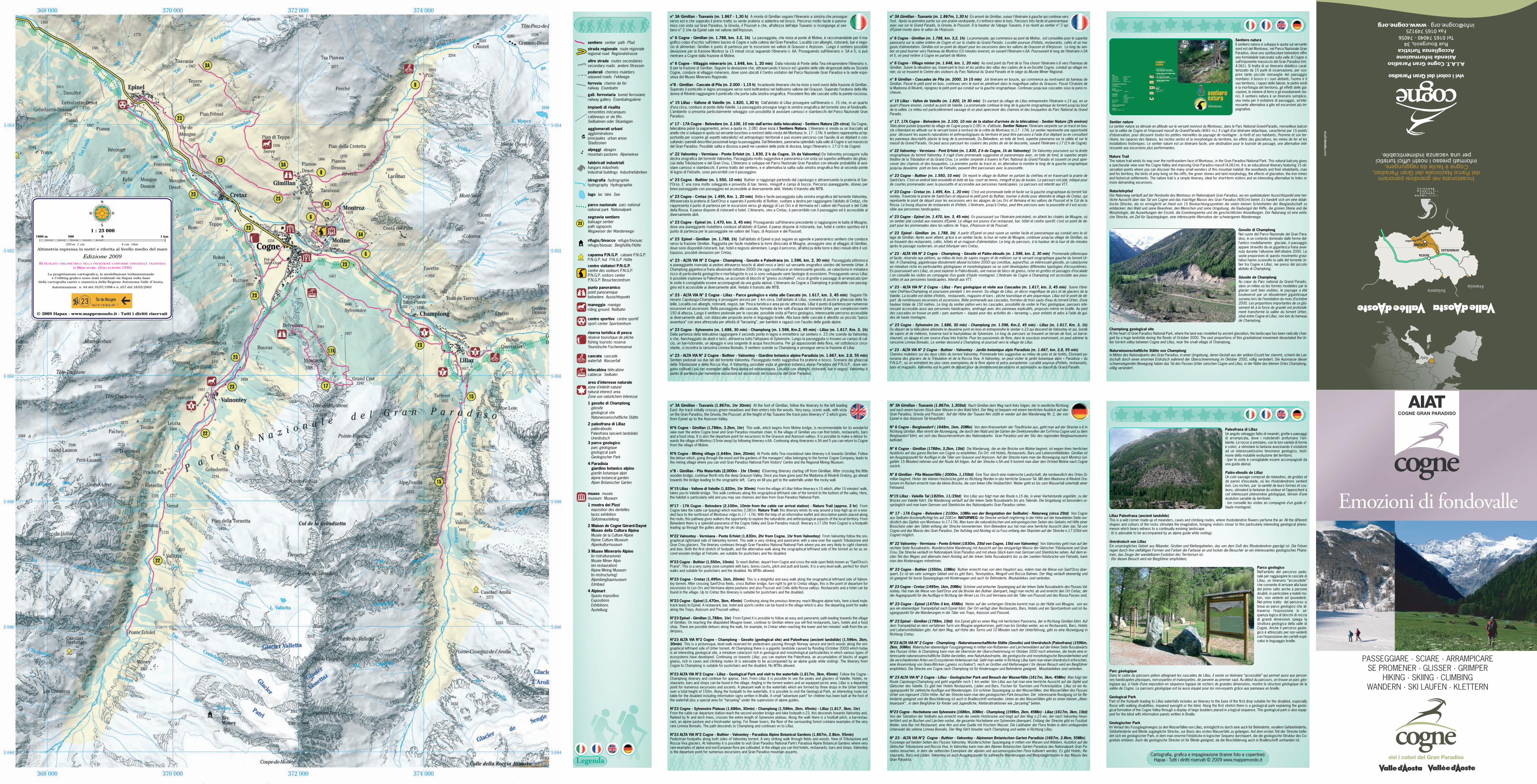
Italy
A.I.A.T. Cogne Gran ParadisoAzienda InformazioneAccoglienza Turistica
Rue Bourgeois,34Tel 0165 74040 - 74056
Fax 0165 [email protected] · www.cogne.org
Incastonata nei grandiosi panoramidelParco Nazionale del Gran Paradiso,
Cogne è facile da raggiungere,informati presso i nostri uffici turistici
per una vacanza indimenticabile.
vivi i colori del Gran Paradiso
AOSTA
COGNEAYMAVILLES
ParcoNazionaleGranParadiso
SvizzeraFrancia
stud
iob
reda.co
m
PASSEGGIARE · SCIARE · ARRAMPICARESE PROMENER · GLISSER · GRIMPER
HIKING · SKIING · CLIMBINGWANDERN · SKI LAUFEN · KLETTERN
Emozioni di fondovalle
vivi i colori del Gran Paradiso
AIATCOGNE GRAN PARADISO
n° 3A Gimillan - Tsavanis (m. 1.867 - 1,30 h) A monte di Gimillan seguire l’itinerario a sinistra che prosegueverso est e che superato il primo tratto su verde prateria si addentra nel bosco. Percorso molto facile e panora-mico con vista sul Gran Paradiso, la Grivola, il Pousset e che, all’altezza dell’alpe Tsavanis si ricongiunge al sen-tiero n° 2 che da Epinel sale nel vallone dell’Arpisson.
n° 6 Cogne - Gimillan (m. 1.788, km. 3.2, 1h) La passeggiata, che inizia al ponte di Moline, è raccomandabile per il ma-gnifico colpo d’occhio sull’intero bacino di Cogne e sulla catena del Gran Paradiso. Località con alberghi, ristoranti, bar e nego-zio di alimentari. Gimillan è punto di partenza per le escursioni nei valloni di Grauson e Arpisson. Lungo il sentiero possibiledeviazione per la frazione Montroz (a 15 minuti circa) seguendo l’itinerario n. 6A. Proseguendo sull’itinerario n. 5A e 5, si puòrientrare a Cogne dalla frazione di Moline.
n° 6 Cogne - Villaggio minerario (m. 1.648, km. 1, 20 min) Dalla rotonda di Ponte della Tina intraprendere l’itinerario n.6 per la frazione di Gimillan. Seguire la deviazione che, attraversando il bosco ed i giardini delle ville dirigenziali della ex SocietàCogne, conduce al villaggio minerario, dove sono ubicati il Centro visitatori del Parco Nazionale Gran Paradiso e la sede espo-sitiva del Museo Minerario Regionale.
n°8 - Gimillan - Cascate di Pila (m. 2.000 - 1,15 h) Incantevole itinerario che ha inizio a nord ovest della frazione di Gimillan.Superato il ponticello in legno proseguire verso nord inoltrandosi nel bellissimo vallone del Grauson. Superato l’oratorio della Ma-donna di Révènti raggiungere il ponticello che porta sulla sinistra orografica. Procedere fino alle cascate sotto la parete rocciosa.
n° 15 Lillaz - Vallone di Valeille (m. 1.820, 1,30 h) Dall’abitato di Lillaz proseguire sull’itinerario n. 15 che, in un quartod’ora circa, conduce al ponte della Valeille. La passeggiata prosegue lungo la sinistra orografica del torrente sino al fondovalle.L’ambiente si presenta particolarmente selvaggio con possibilità di avvistare camosci e stambecchi del Parco Nazionale GranParadiso.
n° 17 - 17A Cogne - Belvedere (m. 2.100, 10 min dall’arrivo della telecabina) - Sentiero Natura (2h circa) Da Cogne,telecabina pulsé (a pagamento), arrivo a quota m. 2.081 dove inizia il Sentiero Natura. L’itinerario si snoda su un tracciato adanello che si sviluppa in quota sul versante boschivo a nord-est della cresta del Montseuc (n. 17 - 17A). Il sentiero rappresenta un’op-portunità per scoprire gli aspetti naturalistici ed antropologici territoriali e può essere percorso con l’ausilio di un dépliant o con-sultando i pannelli descrittivi posizionati lungo la passeggiata. Dal Belvedere, panorama splendido sulla valle di Cogne e sul massicciodel Gran Paradiso. Possibile salita e discesa a piedi nei canaloni delle piste di discesa, lungo l’itinerario n. 17 (2 h da Cogne).
n° 22 Valnontey - Vermiana - Ponte Erfolet (m. 1.830, 2 h da Cogne, 1h da Valnontey) Da Valnontey proseguire sulladestra orografica del torrente Valnontey. Passeggiata molto suggestiva e panoramica con vista sul superbo anfiteatro dei ghiac-ciai della Tribolazione e del Gran Crou. L’itinerario si sviluppa nel Parco Nazionale Gran Paradiso con elevate probabilità di avvi-stare camosci e stambecchi. Il primo tratto del sentiero, e in alternativa la salita sulla sinistra orografica fino al secondo pontedi legno di Fietselin, sono percorribili con il passeggino.
n° 23 Cogne - Buthier (m. 1.550, 10 min) Buthier si raggiunge partendo dal capoluogo e attraversando la prateria di San-t’Orso. E’ una zona molto soleggiata e provvista di bar, tennis, minigolf e campi di bocce. Percorso pianeggiante, idoneo perbrevi passeggiate con passeggino ed accessibile ai diversamente abili. Vietato il transito alle MTB.
n° 23 Cogne - Cretaz (m. 1.495, Km. 1, 20 min) Bella e facile passeggiata sulla sinistra orografica del torrente Valnontey.Attraversata la prateria di Sant’Orso e superato il ponticello di Buthier, svoltare a destra per raggiungere l’abitato di Cretaz, cherappresenta il punto di partenza per le escursioni verso gli alpeggi di Les Ors e di Vermiana ed i valloni del Pousset e del Colledella Rossa. Il paese dispone di ristoranti e hotel. L’itinerario, sino a Cretaz, è percorribile con il passeggino ed è accessibile aidiversamente abili.
n° 23 Cogne - Epinel (m. 1.470, km. 3, 45 min) Proseguendo sull’itinerario precedente si raggiungono le baite di Mougne,dove una pianeggiante mulattiera conduce all’abitato di Epinel. Il paese dispone di ristorante, bar, hotel e centro sportivo ed èpunto di partenza per le passeggiate nei valloni del Trayo, di Arpisson e del Pousset.
n° 23 Epinel - Gimillan (m. 1.788, 1h) Dall’abitato di Epinel si può seguire un agevole e panoramico sentiero che conduceverso la frazione Gimillan. Raggiunta per facile mulattiera la torre diroccata di Mougne, proseguire sino al villaggio di Gimillan,dove sono disponibili ristoranti, bar, hotel e negozio alimentare. Lungo il percorso, all’altezza della torre e dieci minuti oltre il sot-topasso, possibili deviazioni per Cretaz.
n° 23 - ALTA VIA N° 2 Cogne - Champlong - Geosito e Paleofrana (m. 1.596, km. 2, 30 min) Passeggiata pittorescae pianeggiante riservata ai pedoni attraverso boschi di abeti rossi e larici sul versante orografico sinistro del torrente Urtier. AChamplong gigantesca frana alluvionale (ottobre 2000) che oggi costituisce un interessante geosito, un cataclisma in miniaturaricco di particolarità geologiche e morfologiche in cui si sono sviluppate varie tipologie di ecosistemi. Proseguendo verso Lillazè possibile esplorare la Paleofrana, un accumulo di blocchi di “gneiss occhialino”, ricco di grotte e passaggi di arrampicata (perle visite è consigliabile essere accompagnati da una guida alpina). L’itinerario da Cogne a Champlong è praticabile con passeg-gino ed è accessibile ai diversamente abili. Vietato il transito alle MTB.
n° 23 - ALTA VIA N° 2 Cogne - Lillaz - Parco geologico e visita alle Cascate (m. 1.617, km. 3, 45 min) Seguire l’iti-nerario Capoluogo-Champlong e proseguire ancora per 1 km circa. Dall’abitato di Lillaz, scenario di picchi e ghiacciai della Va-leille. Località con alberghi, ristoranti, negozi, bar. Pesca turistica e area pic-nic attrezzata. Lillaz è punto di partenza per numeroseescursioni ed ascensioni. Bella passeggiata alle cascate, formate da tre salti d’acqua del torrente Urtier, per complessivi metri150 di altezza. Lungo il sentiero pedonale per le cascate, possibile visita al Parco geologico, interessante percorso accessibileai diversamente abili, con didascalie proposte anche in linguaggio braille. Alla base delle cascate è allestito un piccolo “parcoavventura” con area attrezzata per attività di “tarzaning”, per bambini e ragazzi con l’ausilio delle guide alpine.
n° 23 Cogne - Sylvenoire (m. 1.686, 30 min) - Champlong (m. 1.596, Km.2, 45 min) - Lillaz (m. 1.617, Km. 3, 1h)Dalla partenza della telecabina raggiungere il secondo ponte in legno e immettersi sul sentiero n. 23 che scende da Valnonteye che, fiancheggiato da abeti e larici, attraversa tutto l’altopiano di Sylvenoire. Lungo la passeggiata si trovano un campo di cal-cio, un bar-ristorante, un alpeggio e una sorgente di acqua freschissima. Per gli appassionati della flora, nel sottobosco circo-stante, si incontra la rarissima Limnea Borealis. Il sentiero scende su Champlong e prosegue verso la frazione di Lillaz
n° 23 - ALTA VIA N° 2 Cogne - Buthier - Valnontey - Giardino botanico alpino Paradisia (m. 1.667, km. 2,8, 55 min)Sentieri pedonali sui due lati del torrente Valnontey. Passeggiata molto suggestiva fra praterie e bosco. Scenario dei ghiacciaidella Tribolazione e della Roccia Viva. A Valnontey, possibile visita al giardino botanico alpino Paradisia del P.N.G.P., dove ven-gono coltivati i più rari esemplari della flora alpina ed extraeuropea. Località con alberghi, ristoranti, bar e negozi. Valnontey èpunto di partenza per numerose escursioni ed ascensioni nel massiccio del Gran Paradiso
n° 3A Gimillan - Tsavanis (1.867m, 1hr 30min) At the foot of Gimillan, follow the itinerary to the left leadingEast: the track initially crosses green meadows and then enters into the woods. Very easy, scenic walk, with vistaon the Gran Paradiso, the Grivola, the Pousset; at the height of Alp Tsavanis the track joins itinerary n° 2 which goesfrom Epinel up to the Arpisson Valley.
N°6 Cogne - Gimillan (1,788m, 3.2km, 1hr) This walk, which begins from Moline bridge, is recommendable for its wonderfulview over the entire Cogne bowl and Gran Paradiso mountain chain. In the village of Gimillan you can find hotels, restaurants, barsand a food shop. It is also the departure point for excursions to the Grauson and Arpisson valleys. It is possible to make a detour to-wards the village of Montroz (15min away) by following itinerary n.6A. Continuing along itineraries n.5A and 5 you can return to Cognefrom the village of Moline.
N°6 Cogne - Mining village (1,648m, 1km, 20min) At Ponte della Tina roundabout take itinerary n.6 towards Gimillan. Followthe detour which, going through the wood and the gardens of the managers’ villas belonging to the former Cogne Company, leads tothe mining village where you can visit Gran Paradiso National Park Visitors’ Centre and the Regional Mining Museum.
n°8 - Gimillan - Pila Waterfalls (2,000m - 1hr 15min) ICharming itinerary starting off from Gimillian. After crossing the littlewooden bridge, continue North into the deep Grauson Valley. Once you have gone past the Madonna di Révènti Oratory, go aheadtowards the bridge leading to the orographic left. Carry on till you get to the waterfalls under the rocky wall.
N°15 Lillaz - Vallone di Valeille (1,820m, 1hr 30min) From the village of Lillaz follow itinerary n.15 which, after 15 minutes’ walk,takes you to Valeille bridge. This walk continues along the orographical left-hand side of the torrent to the bottom of the valley. Here,the habitat is particularly wild and you may see chamois and ibex from Gran Paradiso National Park.
N°17 - 17A Cogne - Belvedere (2,100m, 10min from the cable car arrival station) - Nature Trail (approx. 2 hr) FromCogne take the cable car (paying) which reaches 2,081m. Nature Trail: this itinerary winds its way around a loop high up on a woo-ded face to the north-east of Montseuc ridge (n.17 - 17A). With the help of an informative leaflet and descriptive panels placed alongthe route, this pathway gives walkers the opportunity to explore the naturalistic and anthropological aspects of the local territory. FromBelvedere there is a splendid panorama of the Cogne Valley and Gran Paradiso massif. Itinerary n.17 (2hr from Cogne) is a footpathleading up through the gullies along the ski slopes.
N°22 Valnontey - Vermiana - Ponte Erfolet (1,830m, 2hr from Cogne, 1hr from Valnontey) From Valnontey follow the oro-graphical right-hand side of Valnontey torrent. This walk is very striking and panoramic with a view over the superb Tribolazione andGran Crou glaciers. The itinerary continues through Gran Paradiso National National Park where you are very likely to sight chamoisand ibex. Both the first stretch of footpath, and the alternative walk along the orographical left-hand side of the torrent as far as se-cond wooden bridge at Fietselin, are suitable for pushchairs and the disabled.
N°23 Cogne - Buthier (1,550m, 10min) To reach Buthier, depart from Cogne and cross the wide open fields known as “Sant’Orso’sPrarie”. This is a very sunny zone complete with bars, tennis courts, pitch and putt and bowls. It is a very level walk, perfect for shortwalks and suitable for pushchairs and the disabled. No MTBs allowed.
N°23 Cogne - Cretaz (1,495m, 1km, 20min) This is a delightful and easy walk along the orographical left-hand side of Valnon-tey torrent. After crossing Sant’Orso fields, cross Buthier bridge, turn right to get to Cretaz village, this is the point of departure forexcursions to Les Ors and Vermiana alpine pastures and also Pousset and Colle della Rossa valleys. Restaurants and a hotel can befound in the village. Up to Cretaz this itinerary is suitable for pushchairs and the disabled.
N°23 Cogne - Epinel (1,470m, 3km, 45min) Continuing along the previous itinerary, reach Mougne alpine huts, here a level mule-track leads to Epinel. A restaurant, bar, hotel and sports centre can be found in the village which is also the departing point for walksalong the Trayo, Arpisson and Pousset valleys.
N°23 Epinel - Gimillan (1,788m, 1hr) From Epinel it is possible to follow an easy and panoramic path leading towards the villageof Gimillan. On reaching the dilapidated Mougne tower, continue to Gimillan where you will find restaurants, bars, hotels and a foodshop. There are possible detours along the walk, for example, to Cretaz when reaching the tower and ten minutes’ walk from the un-derpass,
N°23 ALTA VIA N°2 Cogne - Champlong - Geosito (geological site) and Paleofrana (ancient landslide) (1,596m, 2km,30min) This is a picturesque, level walk reserved for pedestrians passing through Norway spruce and larch woods along the oro-graphical left-hand side of Urtier torrent. At Champlong there is a gigantic landslide caused by flooding (October 2000) which todayis an interesting geological site, a miniature cataclysm rich in geological and morphological particularities in which various types ofecosystems have developed. Continuing on towards Lillaz, you can explore the Paleofrana, an accumulation of blocks of augengneiss, rich in caves and climbing routes (it is advisable to be accompanied by an alpine guide while visiting). The itinerary fromCogne to Champlong is suitable for pushchairs and the disabled. No MTBs allowed.
N°23 ALTA VIA N°2 Cogne - Lillaz - Geological Park and visit to the waterfalls (1,617m, 3km, 45min) Follow the Cogne -Champlong itinerary and continue for approx. 1km. From Lillaz it is possible to see the peaks and glaciers of Valeille. Hotels, re-staurants, bars and shops can be found in the village. Angling in the torrent waters and an equipped picnic area. Lillaz is a departingpoint for numerous excursions and ascents. A pleasant walk to the waterfalls which are formed by three drops in the Urtier torrentover a total height of 150m. Along the footpath to the waterfalls, it is possible to visit the Geological Park, an interesting route sui-table for the disabled including information signs written in Braille. A small “adventure park” for children has been built at the foot ofthe waterfall plus a special area for “tarzaning” under the supervision of alpine guides.
N°23 Cogne - Sylvenoire Plateau (1,686m, 30min) - Champlong (1,596m, 2km, 45min) - Lillaz (1,617, 3km, 1hr)From the cable car departure station reach the second wooden bridge and take footpath n.23, this descends towards Valnontey and,flanked by fir and larch trees, crosses the entire length of Sylvenoire plateau. Along the walk there is a football pitch, a bar-restau-rant, an alpine pasture and a fresh-water spring. For flower lovers, the floor of the surrounding forest contains examples of the veryrare Limnea Borealis. The path descends to Champlong and continues on to Lillaz.
N°23 ALTA VIA N°2 Cogne - Buthier - Valnontey - Paradisia Alpine Botanical Gardens (1,667m, 2.8km, 55min)Pedestrian footpaths along both sides of Valnontey torrent. A very striking walk through fields and woods. View of Tribolazione andRoccia Viva glaciers. At Valnontey it is possible to visit Gran Paradiso National Park’s Paradisia Alpine Botanical Gardens where veryrare examples of alpine and non-European flora are cultivated. In the village you can find hotels, restaurants, bars and shops. Valnonteyis the departure point for numerous excursions and Gran Paradiso mountain ascents.
n° 3A Gimillan - Tsavanis (m. 1.867m, 1,30 h) En amont de Gimillan, suivez l'itinéraire à gauche qui continue versl’est. Après la première partie sur une prairie verdoyante, il s'enfonce dans le bois. Parcours très facile et panoramiqueavec vue sur le Grand Paradis, la Grivola, le Pousset. À la hauteur de l’alpage Tsavanis, il se réunit au sentier n° 2 quid’Épinel monte dans le vallon de l’Arpisson.
n° 6 Cogne - Gimillan (m. 1.788, km. 3,2, 1h) La promenade, qui commence au pont de Moline, est conseillée pour le superbepanorama sur la vallée entière de Cogne et sur la chaîne du Grand Paradis. Localité pourvue d’hôtels, restaurants, cafés et un ma-gasin d’alimentation. Gimillan est un point de départ pour les excursions dans les vallons de Grauson et d’Arpisson. Le long du sen-tier on peut tourner vers l’hameau de Montroz (15 minutes environ), en suivant l’itinéraire n.6A. Poursuivant le long de l’itinéraire n.5Aet 5, on peut rentrer à Cogne en partant de Moline.
n° 6 Cogne - Village minier (m. 1.648, km. 1, 20 min) Au rond point du Pont de la Tina choisir l’itinéraire n.6 vers l’hameau deGimillan. Suivre la déviation qui, traversant le bois et les jardins des villas des cadres de la ex-Société Cogne, conduit au village mi-nier, où se trouvent le Centre des visiteurs du Parc National du Grand Paradis et le siège du Musée Minier Régional.
n° 8 Gimillan - Cascades de Pila (m. 2000, 1h 15 min) Joli itinéraire en boucle, qui commence au nord-ouest du hameau deGimillan. Passé le petit pont en bois, continuez vers le nord en pénétrant dans le magnifique vallon du Grauson. Passé l'Oratoire dela Madonna di Révènti, rejoignez le petit pont qui conduit sur la gauche orographique. Continuez jusqu'aux cascades sous la paroi ro-cheuse.
n° 15 Lillaz - Vallon de Valeille (m. 1.820, 1h 30 min) En partant du village de Lillaz entreprendre l’itinéraire n.15 qui, en unquart d’heure environ, conduit au pont de Valeille. La promenade continue le long de la gauche orographique du torrent jusqu’au boutde la vallée. Le milieu est particulièrement sauvage et on peut apercevoir des chamois et des bouquetins du Parc National du GrandParadis.
n° 17, 17A Cogne - Belvedere (m. 2.100, 10 min de la station d’arrivée de la télécabine) - Sentier Nature (2h environ)Télécabine pulsée (payante) du village de Cogne jusqu’à 2.081 m. d’altitude. Sentier Nature: l’itinéraire serpente sur un tracé en bou-cle s’étendant en altitude sur le versant boisé à nord-est de la crête de Montseuc (n.17 - 17A). Le sentier représente une opportunitépour découvrir les aspects naturalistes et anthropologiques du territoire et peut être parcouru à l’aide d’un dépliant ou en consultantles panneaux descriptifs placés le long de la promenade. Du Belvedere, en toile de fond, superbe panorama sur la vallée et sur lemassif du Grand Paradis. On peut aussi parcourir les couloirs des pistes de ski de descente, suivant l’itinéraire n.17 (2 h de Cogne).
n° 22 Valnontey - Vermiana - Pont Erfolet (m. 1.830, 2 h de Cogne, 1h de Valnontey) De Valnontey poursuivre sur la droiteorographique du torrent Valnontey. Il s’agit d’une promenade suggestive et panoramique avec, en toile de fond, le superbe amphi-théâtre de la Tribolation et du Grand Crou. Le sentier serpente à travers le Parc National du Grand Paradis et souvent on peut aper-cevoir des chamois et des bouquetins. La première partie du tracé et, en alternative la montée le long de la gauche orographiquejusqu’au deuxième pont en bois de Fietselin, peuvent être parcourues avec la poussette.
n° 23 Cogne - Buthier (m. 1.550, 10 min) On rejoint le village de Buthier en partant du chef-lieu et en traversant la prairie deSaint-Ours. C’est un endroit bien ensoleillé et doté de bar, court de tennis, minigolf et jeu de boules. Le parcours est plat, indiqué pourde courtes promenades avec la poussette et accessible aux personnes handicapées. Le parcours est interdit aux VTT.
n° 23 Cogne - Cretaz (m. 1.495, Km. 1, 20 min) C’est une promenade belle et facile sur la gauche orographique du torrent Val-nontey. Traversée la prairie de Saint-Ours et dépassé le petit pont du Buthier, tourner à droite pour atteindre le village de Cretaz, quireprésente le point de départ pour les excursions vers les alpages de Les Ors et Vemiana et les vallons de Pousset et le Col de laRossa. Le bourg dispose de restaurants et d’hôtels. L’itinéraire, jusqu’à Cretaz, peut être parcouru avec la poussette et il est acces-sible aux personnes handicapées.
n° 23 Cogne - Epinel (m. 1.470, km. 3, 45 min) En poursuivant sur l’itinéraire précédent, on atteint les chalets de Mougne, oùun sentier plat conduit aux maisons d’Epinel. Le village est pourvu d’un restaurant, bar, hôtel et centre sportif; c’est un point de dé-part pour les promenades dans les vallons de Trayo, d’Arpisson et de Pousset.
n° 23 Epinel - Gimillan (m. 1.788, 1h) A partir d’Epinel on peut suivre un sentier facile et panoramique qui conduit vers le vil-lage de Gimillan. Après avoir atteint, grâce à un sentier facile, la tour en ruine de Mougne, continuer jusqu’au village de Gimillan, oùse trouvent des restaurants, cafés, hôtels et un magasin d’alimentation. Le long du parcours, à la hauteur de la tour et dix minutesaprès le passage souterrain, on peut bifurquer vers Cretaz.
n° 23 - ALTA VIA N° 2 Cogne - Champlong - Géosite et Paléo-éboulis (m. 1.596, km. 2, 30 min) Promenade pittoresqueet facile, réservée aux piétons, au milieu de bois de sapins rouges et de mélèzes sur le versant orographique gauche du torrent Ur-tier. A Champlong, gigantesque éboulement alluvial (octobre 2000) qui constitue, aujourd’hui, un intéressant géosite, un cataclysmeen miniature riche en particularités géologiques et morphologiques où se sont développées différentes typologies d’écosystèmes.En poursuivant vers Lillaz, on peut explorer le Paléo-éboulis, une masse de blocs de gneiss, riche en grottes et passages d’escalade( on conseille les visites en compagnie d’un guide d'haute montagne). L’itinéraire de Cogne à Champlong est accessible aux pous-settes et aux personnes handicapées. Interdit aux VTT.
n° 23 - ALTA VIA N° 2 Cogne - Lillaz - Parc géologique et visite aux Cascades (m. 1.617, km. 3, 45 min) Suivre l’itiné-raire Chef-lieu-Champlong et poursuivre pendant 1 km environ. Du village de Lillaz, un décor magnifique de pics et de glaciers de laValeille. La localité est dotée d’hôtels, restaurants, magasins et bars ; pêche touristique et aire pique-nique. Lillaz est le point de dé-part de nombreuses excursions et ascensions. Belle promenade aux cascades, formées de trois sauts d’eau du torrent Urtier, d’unehauteur totale de 150 mètres. Le long du sentier piéton vers les cascades, possibilité de visiter le Parc géologique, parcours inté-ressant accessible aussi aux personnes handicapées, aménagé avec des panneaux explicatifs, proposés même en braille. Au pieddes cascades on trouve un petit « parc aventure » équipé pour des activités de « tarzaning », pour enfants et ados à l’aide de gui-des de haute montagne.
n° 23 Cogne - Sylvenoire (m. 1.686, 30 min) - Champlong (m. 1.596, Km.2, 45 min) - Lillaz (m. 1.617, Km. 3, 1h)Du départ de la télécabine atteindre le deuxième pont en bois et entreprendre le sentier n.23 qui descend de Valnontey et qui, bordéde sapins et de mélèzes, traverse tout le haut-plateau de Sylvenoire. Le long du parcours se trouvent un terrain de foot, un bar-re-staurant, un alpage et une source d’eau très fraîche. Pour les passionnés de flore, dans le sous-bois environnant, on peut admirer lararissime Limnea Borealis. Le sentier descend à Champlong et poursuit vers le village de Lillaz.
n° 23 - ALTA VIA N° 2 Cogne - Buthier - Valnontey - Jardin botanique alpin Paradisia (m. 1.667, km. 2,8, 55 min)Chemins muletiers sur les deux côtés du torrent Valnontey. Promenade très suggestive au milieu de prés et de forêts. Etonnant pa-norama des glaciers de la Tribulation et de la Roccia Viva. A Valnontey, on peut visiter le jardin botanique alpin « Paradisia » duP.N.G.P., où on entretient les plus rares exemplaires de la flore alpine et extra- européenne. Localité pourvue d’hôtels, restaurants,bars et magasins. Valnontey est le point de départ pour de nombreuses excursions et ascensions au massif du Grand Paradis.
Sentiero naturaIl sentiero natura si sviluppa in quota sul versantenord est del Montseuc, nel Parco Nazionale GranParadiso, dove uno spettacolare belvedere offreuna formidabile balconata sulla valle di Cogne esull’imponente massiccio del Gran Paradiso (mt.4.061). Si tratta di un itinerario didattico carat-terizzato da 15 punti di osservazione, per sco-prire tante piccole meraviglie del paesaggiomontano: il bosco e i suoi abitanti, l’uomo e ilsuo territorio, i rapaci delle falesie, le pietre verdie la morfologia del territorio, gli effetti delle gla-ciazioni, le miniere di ferro e gli insediamenti sto-rici. Il sentiero natura è un itinerario semplice,una meta per il visitatore di passaggio, un’inte-ressante alternativa a gite ed escursioni più im-pegnative.
Sentier natureLe sentier nature se déroule en altitude sur le versant nord-est du Montseuc, dans le Parc National Grand-Paradis, merveilleux balconsur la vallée de Cogne et l’imposant massif du Grand-Paradis (4061 m.). Il s’agit d’un itinéraire didactique, caractérisé par 15 pointsd’observation, pour découvrir toutes les petites merveilles du paysage de montagne : la forêt et ses habitants, l’homme et son ter-ritoire, les rapaces des falaises, les roches vertes et la morphologie du territoire, les effets des glaciations, les mines de fer et lesinstallations historiques. Le sentier nature est un itinéraire facile, une destination pour le touriste de passage, une alternative inté-ressante aux excursions plus performantes.
Nature TrailThe nature trail winds its way over the north-eastern face of Montseuc, in the Gran Paradiso National Park. This natural balcony givesa spectacular view over the Cogne Valley and imposing Gran Paradiso massif (4,061m). It is an educational itinerary featuring 15 ob-servation points where you can discover the many small wonders of this mountain habitat: the woodlands and their inhabitants, manand his territory, the birds of prey living on the cliffs, the green stones and land morphology, the effects of glaciation, the iron minesand historical settlements. The nature trail is a simple itinerary, ideal for short-term visitors and an interesting alternative to treks ormore demanding excursions.
NaturlehrpfadDer Naturweg verläuft auf der Nordseite des Montseuc im Nationalpark Gran Paradiso, wo ein spektakulärer Aussichtspunkt eine her-rliche Aussicht über das Tal von Cogne und das mächtige Massiv des Gran Paradiso (4061m) bietet. Es handelt sich um eine didak-tische Strecke, die es ermöglicht an Hand von 15 Beobachtungspunkten die vielen kleinen Schönheiten der Berglandschaft zuentdecken: den Wald und seine Bewohner, den Menschen und seine Umgebung, die Raubvögel der Kliffe, die grünen Steine und dieMorphologie, die Auswirkungen der Eiszeit, die Eisenbergwerke und die geschichtlichen Ansiedlungen. Der Naturweg ist eine einfa-che Strecke, ein Ziel für Spaziergänger, eine interessante Alternative der schwierigeren Wanderwege.
Geosito di ChamplongNel cuore del Parco Nazionale del Gran Para-diso, in un contesto dominato dalle forme del-l’antico modellamento glaciale, il paesaggioappare stravolto da un gigantesca frana avve-nuta durante l'alluvione dell'ottobre 2000. Levaste proporzioni di questo movimento gravi-tativo hanno sconvolto la valle del torrente Ur-tier tra Cogne e Lillaz, nei pressi del piccoloabitato di Champlong.
Géosite de ChamplongAu cœur du Parc national du Grand Paradis,dans un milieu où les formes modelées par leglacier sont bien visibles, le paysage a étébouleversé par un éboulement gigantesquesurvenu lors de l’inondation du mois d’octobre2000. Les proportions importantes de ce glis-sement lié à la force de gravité ont profondé-ment transformé la vallée du torrent Urtier,situé entre Cogne et Lillaz, non loin du hameaude Champlong.
Champlong geological siteAt the heart of Gran Paradiso National Park, where the land was modelled by ancient glaciation, the landscape has been radically chan-ged by a huge landslide during the floods of October 2000. The vast proportions of this gravitational movement devastated the Ur-tier torrent valley between Cogne and Lillaz, near the small village of Champlong.
Naturwissenschaftliche Stätte von ChamplongIn Mitten des Nationalparks des Gran Paradiso, in einer Umgebung, deren Gestalt aus der antiken Eiszeit her stammt, scheint die Lan-dschaft durch einen enormen Erdrutsch während der Überschwemmung im Oktober 2000, völlig verändert. Die Ausmasse dieserschwerwiegenden Bewegung haben das Tal des Flusses Urtier zwischen Cogne und Lillaz, in der Nähe des kleinen Ortes Champlong,völlig verändert.
Paleofrana di LillazUn angolo selvaggio fatto di meandri, grotte e paesaggidi arrampicata, dove i rododendri profumano l’am-biente. Le rocce si prestano, con le loro varietà di formee colori, a stimolare la fantasia avvicinando il visitatoread un interessantissimo fenomeno geologico, testi-mone della mutabile evoluzione del territorio.- (per le visite è consigliabile essere accompagnati dauna guida alpina).
Paléo-éboulis de LillazUn coin sauvage composé de méandres, de grottes etde parois d’escalade, où les rhododendrons sententbon. Les roches, par la variété de leurs formes et cou-leurs, stimulent la fantaisie du visiteur et l’approchent àcet intéressant phénomène géologique, témoin d’uneévolution variable du territoire.- (on conseille les visites en compagnie d'un guide d'-haute montagne).
Lillaz Paleofrana (ancient landslide)This is a wild corner made up of meanders, caves and climbing routes, where rhododendron flowers perfume the air. All the differentshapes and colours of the rocks stimulate the imagination, bringing visitors closer to this particularly interesting geological pheno-menon which bears witness to a continually evolving landscape.- (it is advisable to be accompanied by an alpine guide while visiting).
Urerdrutsch von LillazEin ursprüngliches Gebiet aus Mäander, Grotten und Klettergebieten, das von dem Duft des Rhododendron geprägt ist. Die Felsenregen durch ihre vielfältigen Formen und Farben die Fantasie an und locken die Besucher an ein interessantes geologisches Phäno-men, das Zeuge der wandelbaren Evolution des Territorium ist.- (für diesen Besuch wird ein Bergführer empfohlen).
Parco geologicoNell’ambito del percorso pedo-nale per raggiungere le cascate diLillaz, un itinerario “accessibile”che consente di arrivare alla basedel primo salto anche a personedisabili, in particolare a inabili mo-tori, non vedenti ed ipovedenti.Nel primo tratto del percorso sitrova un parco geologico che at-traverso l’esposizione in se-quenza logica di blocchi di rocciadi grandi dimensioni spiega lastruttura geologica della valle diCogne. Anche il percorso geolo-gico è attrezzato per non vedenticon l’esposizione dei cartelli espli-cativi in linguaggio braille.
Parc géologiqueDans le cadre du parcours piéton atteignant les cascades de Lillaz, il existe un itinéraire “accessible” qui permet aussi aux person-nes handicapées physiques, non-voyantes et malvoyantes, de parvenir au premier saut. Au début du parcours, on trouve un parc géo-logique qui, à l’aide d’une exposition en séquence logique de rochers de grandes dimensions, montre la structure géologique de lavallée de Cogne. Le parcours géologique est lui aussi équipé pour les non-voyants grâce aux panneaux en braille.
Geological ParkPart of the footpath leading to Lillaz waterfalls includes an itinerary to the base of the first drop suitable for the disabled, especiallythose with walking disabilities, impaired eyesight or the blind. Along the first stretch there is a geological park explaining the geolo-gical formation of the Cogne Valley through a display of large boulders placed in a logical sequence. This geological park is also equip-ped for the blind with information panels written in Braille.
Geologischer ParkIm Verlauf des Fussgängerweges zu den Wasserfällen von Lillaz, ermöglicht es durch eine auch für Behinderte, vorallem Gehbehinderte,Sehbehinderte und Blinde zugängliche Strecke, zur Basis des ersten Wasserfalls zu gelangen. Auf dem ersten Teil der Strecke befin-det sich ein geologischer Park, in dem man enorme Felsblöcke in logischer Sequenz durchquert, die die geologische Struktur des Co-gnetals erklären. Auch die geologische Strecke ist für Blinde geeignet, da die Beschilderung auch in Brailleschrift vorhanden ist.
N° 3A Gimillan - Tsavanis (1.867m, 1,30Std) Nach Gimillan dem Weg nach links folgen, der in westliche Richtungund nach einem kurzen Stück über Wiesen in den Wald führt. Der Weg ist bequem mit einem herrlichen Ausblick auf denGran Paradiso, Grivola und Pousset. Auf der Höhe der Tsavani Alm stößt er wieder auf den Wanderweg Nr. 2, der vonEpinel in das Arpisson Tal hinaufführt.
N° 6 Cogne - Bergbaudorf ( 1648m, 1km, 20Min) Von dem Kreisverkehr der Tina-Brücke aus, geht man auf der Strecke n.6 inRichtung Gimillan. Man nimmt die Abzweigung, die durch den Wald und die Gärten der Direktorenvillen der Ex-Firma Cogne und zu demBergbaudorf führt, wo sich das Besucherzentrum des Nationalparks Gran Paradiso und der Sitz des regionalen Bergbaumuseumsbefindet.
N° 6 Cogne - Gimillan (1788m, 3,2km, 1Std) Die Wanderung, die an der Brücke von Moline beginnt, ist wegen ihres herrlichenAusblicks auf das ganze Becken von Cogne zu empfehlen. Ein Ort mit Hotels, Restaurants, Bars und Lebensmittelläden. Gimillan istein Ausgangspunkt für Ausflüge in die Täler von Grauson und Arpisson. Auf der Strecke kann man die Abzweigung nach Montroz (un-gefähr 15 Minuten) nehmen und der Route 6A folgen. Auf der Strecke n.5A und 5 kommt man über den Ortsteil Moline nach Cognezurück.
N° 8 Gimillan - Pila Wasserfälle ( 2000m, 1,15Std) Eine Tour durch eine malerische Landschaft, die nordwestlich des Ortes Gi-millan beginnt. Hinter der kleinen Holzbrücke geht es Richtung Norden in das herrliche Grauson Tal. Mit dem Madonna di Révènti Ora-torium im Rücken erreicht man die kleine Brücke, die zum linken Ufer hinüberführt. Weiter geht es bis zum Wasserfall unterhalb einerFelswand.
N°15 Lillaz - Valeille Tal (1820m, 11/2Std) Von Lillaz aus folgt man der Route n.15 die, in einer Viertelstunde ungefähr, zu derBrücke von Valeille führt. Die Wanderung verläuft auf der linken Seite flussabwärts bis ans Talende. Die Umgebung ist besonders ur-sprünglich und man kann Gemsen und Steinböcke des Nationalparks Gran Paradiso sehen.
N° 17 - 17A Cogne - Belvedere ( 2100m, 10Min von der Bergstation der Seilbahn) - Naturweg (circa 2Std) Von Cogneaus Seilbahn (kostenpflichtig) bis auf 2081m NATURWEG: die Strecke verläuft ringförmig in der Höhe auf der bewaldeten Seite nor-döstlich des Gipfels von Montseuc (n.17-17A). Man kann die naturalistischen und antropologischen Seiten des Gebiets mit Hilfe einerBroschüre oder den Tafeln entlang der Strecke kennenlernen. Vom Belvedere aus hat man eine herrliche Aussicht über das Tal vonCogne und das Massiv des Gran Paradiso. Der Aufstieg und Abstieg ist zu Fuss entlang den Skipisten auf der Strecke n.17 (2Std vonCogne) möglich.
N° 22 Valnontey - Vermiana - Ponte Erfolet (1830m, 2Std von Cogne, 1Std von Valnontey) Von Valnontey geht man auf derrechten Seite flussabwärts. Wunderschöne Wanderung mit Aussicht auf das einzigartige Massiv der Gletscher Tribolazione und GranCrou. Die Strecke verläuft im Nationalpark Gran Paradiso und mit etwas Glück kann man Gemsen und Steinböcke sehen. Auf dem er-sten Teil des Weges und alternativ beim Anstieg auf der linken Seite flussabwärts bis zu der zweiten Holzbrücke von Fietselin, kannman den Kinderwagen mitnehmen.
N° 23 Cogne - Buthier (1550m, 10Min) Buthier erreicht man von dem Hauptort aus, indem man die Wiese von Sant’Orso über-quert. Es ist ein sehr sonniges Gebiet und es gibt Bars, Tennisplätze, Minigolf und Boccia Bahnen. Der Weg verläuft ebenerdig undist geeignet für kurze Spaziergänge mit Kinderwagen und auch für Behinderte. Moutainbikes sind verboten.
N° 23 Cogne - Cretaz (1495m, 1km, 20Min) Schöner und einfacher Spaziergang auf der linken Seite flussabwärts des Flusses Val-nontey. Hat man die Wiese von Sant’Orso und die Brücke des Buthier überquert, biegt man rechts ab und erreicht den Ort Cretaz, derder Augangspunkt für die Ausflüge in Richtung der Almen Les Ors und Vermiana und der Täler von Pousset und des Rossa Passes sind.
N° 23 Cogne - Epinel (1470m 3 km, 45Min) Weiter auf der vorherigen Strecke kommt man zu der Hütte von Mougne, von woaus ein ebenerdiger Trampelpfad nach Epinel führt. Der Ort verfügt über Restaurants, Bars, Hotels und ein Sportzentrum und ist Au-sgangspunkt für die Wanderungen in die Täler von Trayo, Arpisson und Pousset.
N° 23 Epinel - Gimillan (1788m, 1Std) Von Epinel gibt es einen Weg mit herrlichem Panorama, der in Richtung Gimillan führt. Aufdem Trampelpfad an dem verfallenen Turm von Mougne angekommen, geht man bis Gimillan weiter, wo es Restaurants, Bars, Hotelsund Lebensmittelläden gibt. Auf dem Weg, auf Höhe des Turms und 10 Minuten nach der Unterführung, gibt es eine Abzweigung inRichtung Cretaz.
N°23 ALTA VIA N° 2 Cogne - Champlong - Naturwissenschaftliche Stätte (Geosito) und Urerdrutsch (Paleofrana) (1596m,2km, 30Min) Malerischer ebenerdiger Fussgängerweg in mitten von Rottannen- und Lärchenwäldern auf der linken Seite flussabwärtsdes Flusses Urtier. In Champlong kann man die Überreste der Überschwemmung im Oktober 2000 noch erkennen, die heute eine in-teressante naturwissenschaftliche Stätte darstellen, eine Naturkatastrophe, die geologische und morphologische Besonderheiten unddie verschiedensten Arten von Ecosystemen hinterlassen hat. Geht man weiter in Richtung Lillaz kann man einen Urerdrutsch erforschen,eine Ansammlung von Gneis-Blöcken („gneiss occhialino“), reich an Grotten und Kletterwegen ( für diesen Besuch wird ein Bergführerempfohlen). Die Strecke von Cogne nach Champlong ist für Kinderwagen und Behinderte geeignet. Mountainbikes sind verboten.
N° 23 ALTA VIA N° 2 Cogne - Lillaz - Geologischer Park und Besuch der Wasserfälle (1617m, 3km, 45Min) Man folgt derRoute Capoluogo-Champlong und geht ungefähr noch 1 km weiter. Von Lillaz aus hat man eine herrliche Aussicht auf die Gipfel undGletscher des Valeille. Es gibt hier Hotels Restaurants, Läden und Bars, Fischen für Touristen und Picknickplätze. Lillaz ist ein Au-sgangspunkt für zahlreiche Ausflüge und Wanderungen. Ein schöner Spaziergang zu den Wasserfällen, drei Wasserfällen des FlussesUrtier von ingesamt 150m Höhe. Auf der Strecke kann man den geologischen Park besuchen. Der interessante Rundgang ist für Be-hinderte geeignet und die Beschilderung ist auch in Brailleschrift vorhanden. Unten an den Wasserfällen gibt es einen kleinen „Aben-teuerpark“ , in dem Bergführer für Kinder und Jugendliche, Kletterattraktionen wie „tarzaning“ bieten.
N°23 Cogne - Hochebene von Sylvenoire (1686m, 30Min) - Champlong (1596m, 2km, 45Min) - Lillaz (1617m, 3km, 1Std)Von der Talstation der Seilbahn aus erreicht man die zweite Holzbrücke und biegt auf den Weg n.23 ein, der nach Valnontey hinun-terführt und an Buchen und Lärchen vorbei, die gesamte Hochebene von Sylvenoire überquert. Entlang der Strecke gibt es Fussbal-lfelder, eine Bar mit Restaurant, eine Alm und eine Quelle mit frischem Wasser. Die Liebhaber der Flora finden in dem umliegendenUnterwald die seltene Limnea Borealis. Der Weg führt hinunter nach Champlong und weiter in Richtung Lillaz.
N° 23 - ALTA VIA N°2 Cogne - Buthier - Valnontey - Alpinenen Botanischen Garten Paradisia (1667m, 2.8km, 55Min)Fusswege auf beiden Seiten des Flusses Valnontey. Wunderschöner Spaziergang in mitten von Wiesen und Wäldern. Ausblick auf dieGletscher Tribolazione und Roccia Viva. In Valnontey kann man den Alpinen Botanischen Garten Paradisia des Nationalpark Gran Pa-radiso besuchen, in dem die seltensten Exemplare der alpinen und aussereuropäischen Flora kultiviert werden. Es gibt Hotels, Re-staurants, Bars und Läden. Valnontey ist auch Ausgangspunkt für zahlreiche Wanderungen und Bergsteigertouren in das Massiv desGran Paradiso.
1 : 25 0001000 m 500 0
250 m: 1 cm
Altimetria espressa in metri e riferita al livello medio del mare4 cm: 1 km
1 km
La progettazione cartografica, la modellazione tridimensionale e l’editing grafico sono stati realizzati da Hapax sulla base
della cartografia raster e numerica della Regione Autonoma Valle d’Aosta.
Autorizzazioni: n. 64 del 10/07/1998 e n. 657 del 18/03/2003
© 2009 Hapax - www.mappemondo.it - Tutti i diritti riservati
Edizione 2009RETICOLATO CHILOMETRICO NELLA PROIEZIONE CONFORME UNIVERSALE TRASVERSA
DI MERCATORE. (DATI EUROPEI 1950)
23segnavia sentierobalisage sentier path signposts Wegweiser der Wanderwege
rifugio/bivacco refuge/bivouacrefuge/bivouac Berghütte/Hütte
capanna P.N.G.P. cabane P.N.G.P.P.N.G.P. hut P.N.G.P. Hüttecentro visitatori P.N.G.P. centre des visiteurs P.N.G.P.P.N.G.P. visitors center P.N.G.P. Besucherzentrum
punto panoramico point panoramique belvedere Aussichtspunkt
centro sportivo centre sportif sport center Sportzentrum
riserva turistica di pesca réserve touristique de pêche fishing touristic reserve Touristische Fischenreserve
maneggio manège riding ground Reitbahn
cascata cascade waterfall Wasserfall
telecabina télécabine cablecar Seilbahn
area d'interesse naturalezone d'intérêt naturelnatural interest area Zone von natürlichem Interesse
1 geosito di Champlong géosite
geological site Naturwissenschaftliche Stätte
2 paleofrana di Lillaz paléo-éboulis Paleofrana (ancient landslide)
Urerdrutsch 3 parco geologico
parc géologique geological park
Geologischer Park
4 Paradisia giardino botanico alpino giardin botanique alpin alpine botanical garden
Alpen Botanischer Garten
museo musée museum Museum
1 mostra dei Pizzi exposition des dentelles
laces exhibition Spitzenaustellung
2 Maison de Cogne Gérard-Dayné Museo della Cultura Alpina
Musée de la Culture Alpine Alpine Culture Museum
Alpenkulturmuseum
3 Museo Minerario Alpino (in ristrutturazione) Musée Minier Alpin (en restauration) Alpine Mining Museum (in restructuring) Alpenbergbaumuseum (Umbau)
4 Alpinart Spazio espositivo Expositions Exhibitions Austellung
strada regionale route régionale regional road Regionalstrasse
altre strade routes secondaires secondary roads andere Strassen
agglomerati urbani agglomérations principales urban areas Stadtzonen
ferrovia chemin de fer railway Eisenbahn
lago lac lake See
alpeggi alpages mountain pastures Alpenwiese
parco nazionale parc national national park Nationalpark
gall. ferroviaria tunnel ferroviairerailway gallery Eisenbahngalerie
impianti di risalita remontées mécaniques cableways or ski lifts Seilbahnen oder Skianlagen
sentiero sentier path Pfad
fabbricati industrialihangars industriels industrial buildings Industriefabriken
poderali chemins muletiers unpaved roads Feldwege
idrografia hydrographie hydrography Hydrographie
Cartografia, grafica e impaginazione (tranne foto e copertine):Hapax - Tutti i diritti riservati © 2009 www.mappemondo.itLegenda