CARTA DEI SENTIERI FOOTPATHS GUIDE - parks.it · Nel 1234, con la conquista di Urbino da parte di...
2
CARTA DEI SENTIERI FOOTPATHS GUIDE edizione 2012 Elaborazione grafica: Ufficio Cartografico SERVIZIO 4.1 Urbanistica - Pianificazione Territoriale -VIA - VAS - Aree Protette A.D. & P.:
-
Upload
trinhkhanh -
Category
Documents
-
view
217 -
download
0
Transcript of CARTA DEI SENTIERI FOOTPATHS GUIDE - parks.it · Nel 1234, con la conquista di Urbino da parte di...
CARTA DEI SENTIERI FOOTPATHS GUIDE
edizione 2012Elaborazione grafica: Ufficio Cartografico SERVIZIO 4.1 Urbanistica - Pianificazione Territoriale -VIA - VAS - Aree Protette
A.D. & P.:
Cenni StoriciIl Furlo è stato protagonista di tante vicende storiche. Nei tempi più remoti il suo nome era Saxa Intercisa ovvero Pietra Spaccata o anche Sasso Rotto, in seguito prese la denominazione di Petra Pertusa cioè Pietra Forata. Il nome Furlo proviene da Forulum (Piccolo Foro), volgarizzato poi in Forlo quindi Furlo. La conquista del Furlo da parte dei Romani avvenne senza difficoltà nel 295 a. C., dopo aver sbaragliato la confederazione italica a Sentino (Sassoferrato). La zona fu poi sede di battaglie tra Goti e Bizantini, che a turno la conquistarono e dominarono. Nel 1234, con la conquista di Urbino da parte di Buonconte da Montefeltro, il Furlo entrò a far parte del territorio dei Montefeltro e nel 1631, insieme al Ducato d’Urbino, fu incorporato nello Stato Pontificio. Il 17 settem-bre 1860 il Furlo passò ai Savoia e il 17 marzo 1861 entrò a far parte del Regno d’Italia. Durante la Prima Guerra Mondiale il Passo del Furlo fu utilizzato per il collegamento tra Roma e il fronte. Dal 1922 vi transitò Mussolini le cui soste lo portarono a contatto con l’albergatore Candiracci. Nel 1936 la Milizia Forestale volle immortalare l’immagine del Duce realizzando il famoso profilo sulla monta-gna. Negli anni ottanta sono state costruite due nuove gallerie di 3391 m. che da allora assorbono il traffico della Flaminia, re-stituendo la Gola alla gioia dei suoi estimatori.
History The Furlo Gorge has been the pro-tagonist of many historical events. In ancient times it was called Saxa Intercisa, literally Split Rock or Broken Rock, subsequently it was called Petra Pertusa, literally perforated rock. The name Furlo comes from Forulum (Small Hole), which was then translated into the vernacular Forlo and then Furlo. The Romans conquered the Furlo without any difficulty having routed the Italic confedera-tion at Sentino (Sassoferrato) in 295 BC. The area was then the site of battles between the Goths and the Byzantines, who in turn con-quered and dominated. In 1234, with the con-
quest of Urbino by Buonconte da Montefeltro, Furlo became part of the territory of the Montefeltro family and in 1631, together with the Duchy of Urbino, was incorporated into the Papal State. On 17 September 1860 the Furlo passed to the Savoy and on March 17 1861 it became part of the Kingdom of Italy. During the First World War Furlo was used to link Rome with the frontline. From 1922, Mussolini started passing through the Furlo and his stopovers brought him into contact with the hotelier Candiracci. In 1936 the Forest Militia wanted to im-mortalize the famous profile of the Duce in the mountainside. In the 1980s two new long tunnels of 3391 m. were built absorbing the Flaminia Way traffic and restoring the gorge to its delighted admirers.
La FlaminiaLa strada consolare Flaminia fu realizzata attorno al 220 a.C. per volere di Gaio Flaminio, come collegamento tra Roma e Ariminum (Rimini). Il piano stradale venne ricavato in trincea, aggirando lo sperone della montagna e praticando, per un lungo tratto di quasi 200 m, dei tagli sulla parete rocciosa, ottenuti con piccone, mazza e scalpello per un’altezza di 10-12 m. Tale piano di transito esterno alla montagna, largo tra 5,4 e 6 m, è in parte ancora ben conservato e sono riconoscibili i solchi dei carri che lo percorrevano a doppio senso di mar-cia. Ma alcuni cedimenti verificatisi già in antico, determinarono l’inagibilità di una parte del piano stradale e il conseguente abbandono del primo tracciato. Verosimilmente in età augustea (27 a.C.- 14 d.C.) venne creata una serie di imponenti muri di terrazzamento e fu spostato il percorso in galleria. I muri di sostruzione, ancora oggi ben visibili, anche se in parte sommersi dalle acque del lago, sostenevano la carreggiata nei punti critici per un tratto di circa mezzo km e raggiungevano dimensioni eccezionali di circa 20 m. La prima galleria, di piccole dimensioni (lunga 8 m e larga circa 3.30 m) e di fattura poco regolare, fu scavata come soluzione temporanea, permettendo il passaggio di un solo carro. Mentre la seconda galleria (quella ancora attualmente in uso) venne rea-lizzata dall’imperatore Vespasiano, fra il 76 e il 77 d.C.
The Flaminia the consular road Flaminia was built around 220 BC at the be-hest of Gaius Flaminius to link Rome and Ariminum (Rimini). The roadway was dug out as a trench, bypassing the spur of the mountain for a long stretch of
nearly 200 m by making cuts in the rock wall using a pick, mallet and chisel to a height of 10-12 m. This initial road, running around the mountain was between 5.4 and 6m wide, and is in part still well pre-served. Even now, it is possible to see the ruts of the cart wheels that travelled this two-lane road. How-ever, some subsidence, already evident even then, meant that part of the road was not usable with the consequent neglect of this first track. Probably in the Augustan Age (27 BC-14 AD) a series of imposing terraced walls were built and the road was diverted through the tunnel. The substructure walls, still visible today although partially submerged in the lake, supported the road at significant points for a distance of about half a kilometre and reached extraordinary dimensions of about 20 m. The first smaller tunnel (length 8 m with a width of about 3.30 m) built in a rather haphazard fashion, was dug out as a temporary solution, allowing the passage of only a single cart. While the second tunnel (the one still in use today) was built by Emperor Vespasian between 76 and 77 AD.
La Diga del FurloSul Fiume Candigliano, in Comune di Fermignano, è ubicata la diga del Furlo finita di realizzare nel 1922. E’ del tipo ad arco gravità, alta 59 metri con uno sviluppo del coronamento di 50 metri ed è una tra le più famose e spettacolari del Centro Italia. Alimenta la centrale idroelettrica posta poco più a valle e ha causato un aumento del livello del Fiume Candigliano per una lunghezza di circa 3 Km, creando un lago artificiale. L’accesso alla diga è situato in sponda sinistra e conduce al locale di guardia da cui, proseguendo sul coronamento, si raggiunge la sponda destra ove è ubicata la camera di manovra dello scarico di fondo. La quota di massimo invaso è di 175,68 m.s.l.m. e le quote di minima e massima regolazione rispettivamente di 169,16 m.s.l.m. e 174,68 m.s.l.m.. La centrale idroelettrica, localizzata in origine ai piedi della diga è stata comple-
tamente distrutta durante il secondo conflitto mondiale. La nuova centrale è stata ricostruita più a valle nel 1952.
The Furlo dam On the river Can-digliano, in the district of Fermignano, the Furlo dam was finished in 1922. It’s an arch-gravity dam, 59 metres high with a walkway at the top 50 metres in length and it is one of the most famous and impressive in central Italy. It feeds the central hydroelectric power station a little further downstream and has led to an increase in the level of the Can-digliano river for a length of about 3 km creating a reservoir. Access to the dam is situated on the left bank and takes you to the security office and from there continuing along the crown, you reach the right hand side of the dam where the control room for the bottom drain is located. The maximum amount flowing through is 175.68 (metres above sea level) and the minimum and maxi-mum adjustment respectively is 169.16 msl and 174.6 msl. The hydroelectric plant, originally located at the foot of the dam was completely destroyed during the Second World War. The new plant was rebuilt further downstream in 1952.
Le CaveLa Riserva nel passato è stata interessata da un’intensa attività estrattiva che per molti decenni ha fornito materiale lapideo calcareo molto apprezzato. È ancora possibile osservare numerose cave dismesse, alcune delle quali con interessanti superfici molto ampie.
The Quarries In the past, the Reserve was the scene of intense mining activity which for many decades provided much appreciated limestone. It is still pos-sible to see many abandoned quarries, some of which cover large areas.
TartuficolturaGrazie alle particolari caratteristiche ambientali il territorio della Riserva è ca-ratterizzato dalla presenza di numerose specie di Tartufo: il Tartufo bianco, il Tartufo nero d’inverno, il Tartufo nero estivo o Scorzone, il Tartufo bianchetto e il Tartufo nero pregiato. Il territorio della Riserva è particolarmente vocato alla produzione tartufigena, in particolare del Tartufo nero pregiato. La storia della tartuficoltura al Furlo risale al 1932, quando Francesco Francolini, direttore della Cattedra Ambulante di Agricoltura di Spoleto, realizzò sul M. Pietralata la prima tartufaia artificiale non sperimentale della storia della tartuficoltura italiana. Il generale Lorenzo Mannozzi Torini, grande appassionato di tartufi, incrementò la presenza di tartufaie coltivate raggiungendo nel 1958 la superficie di 52 ha. Degna di nota è la tartufaia che Mannozzi-Torini impiantò sul M. Paganuccio negli anni sessanta.
Truffle Cultivation Due to the particular environmental characteristics of the land, the Reserve has several species of truffle: the white truffle, the winter black truffle, the black summer truffle or Scorzone, the whitish truffle and the black diamond truffle. The area of the Reserve is particularly suited to truffle produc-tion, especially the black diamond truffle. The history of truffle cultivation in Furlo dates back to 1932, when Francesco Francolini, Director of the Itinerant Professorship of Agriculture in Spoleto, produced on M. Pietralata the first non experimental artificial truffle farm in the history of the Italian cultivated truffle. General Lorenzo Mannozzi Torini, a great lover of truffles, increased the num-bers of cultivated truffles with up to 52 hectares by 1958. Worth mentioning is the truffle farm created by Mannozzi-Torini on Monte Paganuccio in the 1960s.
Aspetti Geologici e PaleontologiciI Monti del Furlo sono caratterizzati da un’ampia struttura anti-clinalica con nucleo di terreni giurassici affioranti sui lati della Gola del Furlo. La Gola del Furlo è il risultato di un processo di antecedenza e cioè la Gola è stata incisa, anche grazie alla presenza di fratture e faglie, dal corso d’acqua contempora-neamente al sollevamento della dorsale appenninica. Il M.
Pietralata (889 m) e il M. Paganuccio (976 m) sono ciò che resta dell’anticlinale Il complesso montuoso è formato da calcari di origine sedimentaria appartenenti alla cosiddetta Successione Umbro-Marchigiana, risalente tra 240 e 15 milioni di anni fa. La successione delle unità litostratigrafiche a partire dai termini più antichi comprende Calcare Massiccio, Corniola, Rosso Ammonitico, Formazio-ne del Bugarone, Calcari Diasprigni e Calcari e Marne a Posidonia, Calcari a Saccoma ed Aptici, Maiolica, Marne a Fucoidi, Scaglia Bianca, Scaglia Rossa, Scaglia Variegata, Scaglia Cinerea, Bisciaro, Schlier. Le formazioni rocciose del Giurassico che affiorano ampiamente nella Gola del Furlo e nel Buzzo sono ricche di Ammoniti, Molluschi Cefalopodi a conchiglia ritorta e variamente or-nata che ebbero un’eccezionale diffusione nei mari del Mesozoico, da 225 a 65 milioni di anni fa. La Gola del Furlo risulta essere uno dei giacimenti più ricchi e famosi d’Europa. Fra queste Ammoniti alcuni generi e specie hanno nomi che fanno riferimento al Furlo, ad esempio i generi Furloceras e Furlites e la specie Taffertia furlensis.
Geology and Palaeontology The Furlo mountains are characterised by a large anticlinal structure with the core of this Jurassic land running along the sides of the Furlo Gorge. The Furlo Gorge is the result of a process of an-tecedence, meaning that the Gorge was carved out, helped by the pres-ence of faults and fractures, by the river and occurring in parallel to the Appenine lift. Mount Pietralata (889 m) and Mount Paganuccio (976 m) are what remains of this anticlinal struc-ture. The mountain range is made up of limestone of sedimentary origin belonging to the so-called Umbria-Marche Succession, dating from be-tween 15 to 240 million years ago. This succession of lithostratigraphic units from the oldest respectively includes
the Calcare Massiccio, the Corniola, the Rosso Ammonitico, the Bugarone For-mation, Calcari Diasprigni and Calcari, Marne a Posidonia, Calcari a Saccoma and Aptici, Maiolica, Marne a Fucoidi, Scaglia Bianca, Scaglia Rossa, Scaglia Variegata, Scaglia Cinerea, Bisciaro, and Schlier.The Jurassic rock formations seen extensively alongside the Furlo and Buzzo gorges are rich in Ammonites, Cephalopod Molluscs, a spiral shell, interestingly ornamented which was very widespread in the seas of the Mesozoic era, 225 million to 65 million years ago. The Furlo Gorge is one of the richest and most famous fossil deposits in Europe. Among the Ammonites are some genera and species with names that refer to the Furlo area, for example the genera Fur-loceras and Furlites and the species Taffertia furlensis.
Aspetti Botanico - VegetazionaliLa flora è ampiamente diversificata: sono presenti specie mediterra-nee e termofile, abitualmente rintracciabili in territori caldi o costie-ri della regione e piante tipiche delle montagne elevate dell’Appen-nino Umbro-Marchigiano, spesso in nicchie ecologiche contigue. In particolare, la gola rupestre, in virtù della sua multiformità ambientale, oltre a offrire un paesaggio di stupefacente bellezza, costituisce, dal punto di vista floristico, il settore più importante e più ricco dell’intero complesso montuoso con oltre mille specie di piante. Fra di esse si ricordano la Campanula di Tanfa-ni (Campanula tanfanii), lo Sparviere lacerato (Hieracium umile), la Campanula graminifolia (Edraianthus graminifolius); la Gramigna dell’Appennino (Trisetaria villosa), piccole felci rupicole come l’Asplenio grazioso (Asplenium lepidum) e l’Asplenio tricomane (Aspelnium trichomanes subsp. pachyrachis), il Giacinto dal pennacchio (Muscari tenuiflorum), il Lilioasfodelo maggiore (Anthericum li-liago), la Sesleria dell’Appennino (Sesleria apennina) e soprattutto la rara ed endemica Moehringia papulosa. La lecceta, presente sul margine superiore del-la Gola e nei versanti orientali del M. Petralata e M. Paganuccio, vede, oltre al Leccio, Ornielli, Aceri, Sorbi, Terebinto, Ciliegio canino, altre specie mediterra-nee sempreverdi come il Corbezzolo, la Fillirea, lo Smilace e il Laurotino. Fra gli alberi, spicca il Bagolaro, presente nella regione in pochissime località. Le formazioni boschive termofile caducifoglie della Riserva sono formate da quer-ceti e ostrieti con Orniello, Carpino nero, Roverella, Acero minore e arricchite
dalla presenza di altre specie arboree o arbustive come il Pero Corvino, l’Albero di Giuda, la Berretta da prete, ecc. Ai margini dei boschi non è raro imbattersi nel Citiso nero. Nella Gola è presente anche la rara Vite selvatica (Vitis vinifera subsp. sylvestris). Nei versanti freddi del M. Paganuccio e del M. Pietralata sono presenti boschi mesofili, governati generalmente a ceduo e solo localmente ad alto fusto. Particolarmente interessante è la faggeta presente nel versan-te settentrionale del M. Paganuccio in cui, accanto al Faggio si trovano molte delle specie dei querceti e degli ostrieti, ma anche Carpino bianco, Fusaggine montana, Cerro e una flora erbacea molto varia caratterizzata dalla presenza di specie mesofile come Bucaneve, Dentarie, Viole, Gigaro scuro, Erba lucciola, Sigillo di Salomone, Doronico di Colonna, ecc. Nelle praterie, di origine secon-daria, sono abbondanti Ranuncolacee, Leguminose, Ombrellifere, Composite, Labiate, Graminacee e tante altre.Fra le entità più interessanti vanno ricordate: Crocus biflorus, Orchis militaris e Dactylorhiza romana.
Botanical and Vegetative Features The flora in the Reserve is highly di-verse. There are Mediterranean and thermophile species, normally found in hot or coastal areas of the region as well as plants typical of the elevated mountains of the Umbria-Marche Apennine range, often in contiguous ecological niches. In particular, the rocky Gorge, because of its environmental richness, in addi-tion to offering a landscape of breathtaking beauty, is, from the point of view of flora, the most important and richest of this entire mountain complex with over a thousand species of plants. Included among them are the Campanula di Tanfani (Campanula tanfanii), Dwarf Hawkweed (Hieracium umile), Edrianthus (Edraian-thus graminifolius); Appenine Spear Grass (Trisetaria villosa), small rock crevice ferns like the l’Asplenio grazioso (Asplenium lepidum) and Common Spleenwort (Aspelnium trichomanes subsp. pachyrachis), Giacinto dal pennacchio (Mus-cari tenuiflorum), St. Bernard’s Lily (Anthericum liliago), Sesleria dell’Appennino (Sesleria apennina) and above all the rare and endemic Moehringia papulosa. The Holm oak woods present on the upper margin of the Gorge and the eastern slopes of Mt. Pietralata and Mt. Paganuccio include not only Holm oak, the Manna ash, the Maple, Mountain Ash, Turpentine Trees, Mahaleb Cherry but also other evergreen Mediterranean species such as the Strawberry Tree, Phyl-lirea, the Smilace and Tinus Laurei.
One tree of par-ticular note is the Hackberry which is present in very few places in the region. The decid-uous woodlands in the Reserve are made up of oak and hornbeams with Flowering Ash, Hop Hornbeam, Downy Oak, Montpelier Maple and en-riched by the presence of other species of tree and shrub species such as the Crow Pear, Judas Tree, the Spindle Tree etc. On the edge of the woods it is not unusual to find Black Broom and in the Gorge itself there is also a rare wild Vine. (Vitis vinifera subsp. Sylvestris). On the cold slopes of Mt. Paganuccio and Mt. Pietralata are mesophile woodlands, generally copse in nature and, only locally, populated by forest trees. Particularly interesting is the beech forest on the northern slope of Mount Paga-nuccio where, in addition to the beech trees there are many species of oak and hornbeams, but also the European Hornbeam, the Spindle Tree, the Turkey Oak. The herbaceous flora is also very varied characterized by the presence of mes-ophile species as Snowdrop, Dentaria, Violets, Lords and Ladies, Woodrush, Solomon’s Seal, Eastern Leopard’s Bane, etc.. In the pastures, of secondary origin, there are many plants belonging to the Ranuncolacee, Leguminose, Um-belliferae, Composite, Labiate, Graminaceous families as well as others. Among the most significant are: Crocus biflorus, the Military Orchid and the Dacty-lorhiza romana.
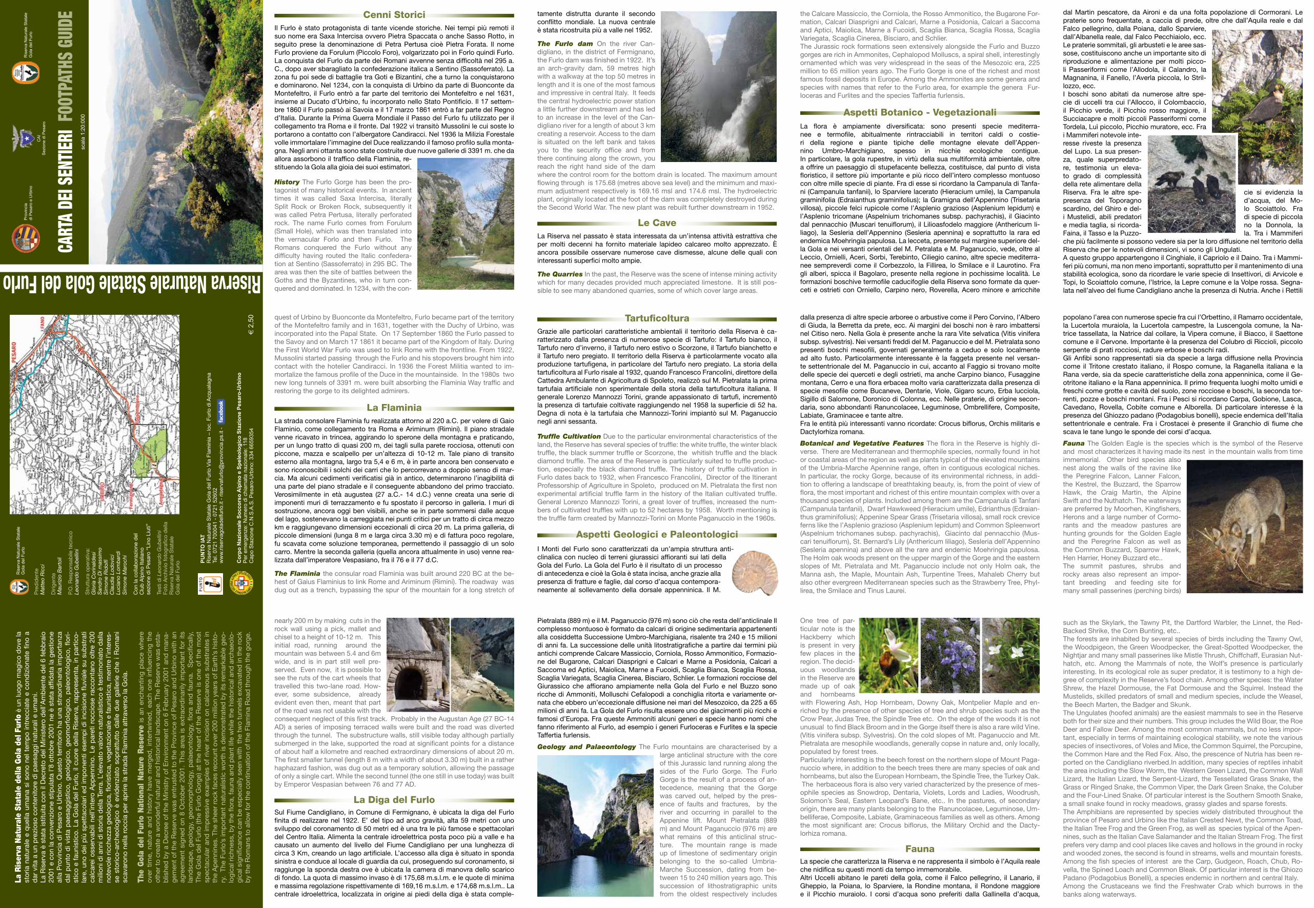
FaunaLa specie che caratterizza la Riserva e ne rappresenta il simbolo è l’Aquila reale che nidifica su questi monti da tempo immemorabile.Altri Uccelli abitano le pareti della gola, come il Falco pellegrino, il Lanario, il Gheppio, la Poiana, lo Sparviere, la Rondine montana, il Rondone maggiore e il Picchio muraiolo. I corsi d’acqua sono preferiti dalla Gallinella d’acqua,
popolano l’area con numerose specie fra cui l’Orbettino, il Ramarro occidentale, la Lucertola muraiola, la Lucertola campestre, la Luscengola comune, la Na-trice tassellata, la Natrice dal collare, la Vipera comune, il Biacco, il Saettone comune e il Cervone. Importante è la presenza del Colubro di Riccioli, piccolo serpente di prati rocciosi, radure erbose e boschi radi.Gli Anfibi sono rappresentati sia da specie a larga diffusione nella Provincia come il Tritone crestato italiano, il Rospo comune, la Raganella italiana e la Rana verde, sia da specie caratteristiche della zona appenninica, come il Ge-otritone italiano e la Rana appenninica. Il primo frequenta luoghi molto umidi e freschi come grotte e cavità del suolo, zone rocciose e boschi, la seconda tor-renti, pozze e boschi montani. Fra i Pesci si ricordano Carpa, Gobione, Lasca, Cavedano, Rovella, Cobite comune e Alborella. Di particolare interesse è la presenza del Ghiozzo padano (Podagobius bonelli), specie endemica dell’Italia settentrionale e centrale. Fra i Crostacei è presente il Granchio di fiume che scava le tane lungo le sponde dei corsi d’acqua.
Fauna The Golden Eagle is the species which is the symbol of the Reserve and most characterizes it having made its nest in the mountain walls from time immemorial. Other bird species also nest along the walls of the ravine like the Peregrine Falcon, Lanner Falcon, the Kestrel, the Buzzard, the Sparrow Hawk, the Craig Martin, the Alpine Swift and the Nuthatch. The waterways are preferred by Moorhen, Kingfishers, Herons and a large number of Cormo-rants and the meadow pastures are hunting grounds for the Golden Eagle and the Peregrine Falcon as well as the Common Buzzard, Sparrow Hawk, Hen Harrier, Honey Buzzard etc..The summit pastures, shrubs and rocky areas also represent an impor-tant breeding and feeding site for many small passerines (perching birds)
such as the Skylark, the Tawny Pit, the Dartford Warbler, the Linnet, the Red-Backed Shrike, the Corn Bunting, etc..The forests are inhabited by several species of birds including the Tawny Owl, the Woodpigeon, the Green Woodpecker, the Great-Spotted Woodpecker, the Nightjar and many small passerines like Mistle Thrush, Chiffchaff, Eurasian Nut-hatch, etc. Among the Mammals of note, the Wolf’s presence is particularly interesting. In its ecological role as super predator, it is testimony to a high de-gree of complexity in the Reserve’s food chain. Among other species: the Water Shrew, the Hazel Dormouse, the Fat Dormouse and the Squirrel. Instead the Mustelids, skilled predators of small and medium species, include the Weasel, the Beech Marten, the Badger and Skunk.The Ungulates (hoofed animals) are the easiest mammals to see in the Reserve both for their size and their numbers. This group includes the Wild Boar, the Roe Deer and Fallow Deer. Among the most common mammals, but no less impor-tant, especially in terms of maintaining ecological stability, we note the various species of insectivores, of Voles and Mice, the Common Squirrel, the Porcupine, the Common Hare and the Red Fox. Also, the prescence of Nutria has been re-ported on the Candigliano riverbed.In addition, many species of reptiles inhabit the area including the Slow Worm, the Western Green Lizard, the Common Wall Lizard, the Italian Lizard, the Serpent-Lizard, the Tessellated Grass Snake, the Grass or Ringed Snake, the Common Viper, the Dark Green Snake, the Coluber and the Four-Lined Snake. Of particular interest is the Southern Smooth Snake, a small snake found in rocky meadows, grassy glades and sparse forests.The Amphibians are represented by species widely distributed throughout the province of Pesaro and Urbino like the Italian Crested Newt, the Common Toad, the Italian Tree Frog and the Green Frog, as well as species typical of the Apen-nines, such as the Italian Cave Salamander and the Italian Stream Frog. The first prefers very damp and cool places like caves and hollows in the ground in rocky and wooded zones, the second is found in streams, wells and mountain forests. Among the fish species of interest are the Carp, Gudgeon, Roach, Chub, Ro-vella, the Spined Loach and Common Bleak. Of particular interest is the Ghiozo Padano (Podagobius Bonelli), a species endemic in northern and central Italy.Among the Crustaceans we find the Freshwater Crab which burrows in the banks along waterways.
dal Martin pescatore, da Aironi e da una folta popolazione di Cormorani. Le praterie sono frequentate, a caccia di prede, oltre che dall’Aquila reale e dal Falco pellegrino, dalla Poiana, dallo Sparviere, dall’Albanella reale, dal Falco Pecchiaiolo, ecc. Le praterie sommitali, gli arbusteti e le aree sas-sose, costituiscono anche un importante sito di riproduzione e alimentazione per molti picco-li Passeriformi come l’Allodola, il Calandro, la Magnanina, il Fanello, l’Averla piccola, lo Stril-lozzo, ecc.I boschi sono abitati da numerose altre spe-cie di uccelli tra cui l’Allocco, il Colombaccio, il Picchio verde, il Picchio rosso maggiore, il Succiacapre e molti piccoli Passeriformi come Tordela, Luì piccolo, Picchio muratore, ecc. Fra i Mammiferi notevole inte-resse riveste la presenza del Lupo. La sua presen-za, quale superpredato-re, testimonia un eleva-to grado di complessità della rete alimentare della Riserva. Fra le altre spe- cie si evidenzia la presenza del Toporagno d’acqua, del Mo-scardino, del Ghiro e del- lo Scoiattolo. Fra i Mustelidi, abili predatori di specie di piccola e media taglia, si ricorda- no la Donnola, la Faina, il Tasso e la Puzzo- la. Tra i Mammiferi che più facilmente si possono vedere sia per la loro diffusione nel territorio della Riserva che per le notevoli dimensioni, vi sono gli Ungulati.A questo gruppo appartengono il Cinghiale, il Capriolo e il Daino. Tra i Mammi-feri più comuni, ma non meno importanti, soprattutto per il mantenimento di una stabilità ecologica, sono da ricordare le varie specie di Insettivori, di Arvicole e Topi, lo Scoiattolo comune, l’Istrice, la Lepre comune e la Volpe rossa. Segna-lata nell’alveo del fiume Candigliano anche la presenza di Nutria. Anche i Rettili
La R
iser
va N
atur
ale
Stat
ale
della
Gol
a de
l Fur
lo è
un
luog
o m
agic
o d
ove
la
stor
ia n
atur
ale
e q
uella
um
ana
si s
ono
nel t
emp
o in
trec
ciat
e e
cond
izio
nate
fino
a
dar
vita
a u
n p
rezi
oso
cont
enito
re d
i pae
sagg
i nat
ural
i e u
man
i. La
Ris
erva
è s
tata
istit
uita
con
il D
ecre
to d
el M
inis
tero
del
l’Am
bie
nte
del
6 fe
bb
raio
20
01 e
con
la c
onve
nzio
ne s
tipul
ata
l’8 o
ttob
re 2
001
ne è
sta
ta a
ffid
ata
la g
estio
ne
alla
Pro
vinc
ia d
i Pes
aro
e U
rbin
o. Q
uest
o te
rrito
rio h
a un
a st
raor
din
aria
imp
orta
nza
dal
pun
to d
i vis
ta p
aesa
ggis
tico,
geo
logi
co,
geom
orfo
logi
co,
pal
eont
olog
ico,
flor
i-st
ico
e fa
unis
tico.
La
Gol
a d
el F
urlo
, il c
uore
del
la R
iser
va, r
app
rese
nta,
in p
artic
o-la
re,
uno
dei
più
sp
etta
cola
ri ed
imp
onen
ti es
emp
i di i
ncis
ione
fluv
iale
su
sub
stra
ti ca
lcar
ei o
sser
vab
ili n
ell’i
nter
o A
pp
enni
no.
Le p
aret
i roc
cios
e ra
ccon
tano
oltr
e 20
0 m
ilion
i di a
nni d
i sto
ria d
ella
Ter
ra. L
’ele
vato
val
ore
natu
ralis
tico
è te
stim
onia
to d
alla
no
tevo
le ri
cche
zza
geol
ogic
a, fl
oris
tica,
veg
etaz
iona
le e
faun
istic
a, m
entr
e l’i
nter
es-
se s
toric
o-ar
cheo
logi
co è
evi
den
ziat
o so
pra
ttut
to d
alle
due
gal
lerie
che
i R
oman
i sc
avar
ono
nella
roc
cia
per
ap
rire
la s
trad
a Fl
amin
ia a
ttra
vers
o la
Gol
a.
The
Gol
a de
l Fu
rlo
Nat
iona
l N
atur
e R
eser
ve i
s an
enc
hant
ing
pla
ce w
here
ov
er t
ime,
nat
ure
and
his
tory
hav
e m
erge
d,
inte
rtw
ined
, ea
ch o
ne i
nflue
ncin
g th
e ot
her t
o cr
eate
a w
ond
erfu
l nat
ural
and
his
toric
al la
ndsc
ape.
The
Res
erve
was
est
a-b
lishe
d b
y a
Dec
ree
of t
he M
inis
try
of E
nviro
nmen
t on
6 F
ebru
ary
2001
and
man
a-ge
men
t of t
he R
eser
ve w
as e
ntru
sted
to th
e P
rovi
nce
of P
esar
o an
d U
rbin
o w
ith a
n ag
reem
ent
sign
ed o
n 8
Oct
ober
200
1. T
his
area
is e
xtra
ord
inar
ily im
por
tant
for
its
land
scap
e, g
eolo
gy,
geom
orp
holo
gy,
pal
aeon
tolo
gy,
flora
and
fau
na.
Sp
ecifi
cally
, Th
e G
ola
del
Fur
lo (t
he F
urlo
Gor
ge) a
t th
e he
art
of t
he R
eser
ve is
one
of
the
mos
t sp
ecta
cula
r an
d im
pre
ssiv
e ex
amp
les
of r
iver
inci
sion
on
calc
areo
us s
ubst
rate
s in
th
e A
pen
nine
s. T
he s
heer
rock
face
s re
coun
t ove
r 200
mill
ion
year
s of
Ear
th’s
his
to-
ry.
The
Furlo
’s im
por
tant
nat
ural
istic
wor
th is
dem
onst
rate
d b
y its
rem
arka
ble
geo
-lo
gica
l ric
hnes
s, b
y th
e flo
ra, f
auna
and
pla
nt li
fe w
hile
the
hist
oric
al a
nd a
rcha
eolo
-gi
cal s
igni
fican
ce c
an b
e es
pec
ially
see
n w
ith t
he tw
o tu
nnel
s ex
cava
ted
in th
e ro
ck
by
the
Rom
ans
to a
llow
for t
he c
ontin
uatio
n of
the
Flam
ina
Roa
d th
roug
h th
e go
rge.
Riserva Naturale Statale Gola del Furlo
Pro
vinc
iadi
Pes
aro
e U
rbin
oR
iser
va N
atur
ale
Sta
tale
Gol
a de
l Fur
lo
CA
IS
ezio
ne d
i Pes
aro
scal
a 1:
20:0
00
€ 2
,50
CART
A DE
I SEN
TIERI
FOO
TPAT
HS G
UIDE
Pre
did
ente
Mat
teo
Ric
ci
Diri
gent
eM
auriz
io B
arto
li
P.O
. Res
pon
sab
ile t
ecni
coLe
onar
do
Gub
ellin
i
Str
uttu
ra o
per
ativ
a:G
loria
Cor
inal
des
i S
and
ro D
i mas
sim
o S
imon
e R
idol
fiC
laud
ia L
odov
ici
Luci
ano
Lom
bar
di
Sim
one
Mar
ochi
Con
la c
olla
bor
azio
ne d
elC
lub
Alp
ino
Italia
nose
zion
e d
i Pes
aro
“Lin
o Li
uti”
Test
i di L
eona
rdo
Gub
ellin
iFo
to A
rchi
vio
foto
grafi
co d
ella
R
iser
va N
atur
ale
Sta
tale
G
ola
del
Fur
lo Co
rpo
Naz
ion
ale
So
cco
rso
Alp
ino
e S
pel
eolo
gic
o S
tazi
on
e P
esar
o-U
rbin
oP
er e
mer
genz
e: N
umer
o di
chi
amat
a na
zion
ale:
118
C
apo
Sta
zion
e C
.N.S
.A.S
. Pes
aro-
Urb
ino:
334
665
9354
PU
NT
O IA
T
Ris
erva
Nat
ural
e S
tata
le G
ola
del F
urlo
Via
Fla
min
ia –
loc.
Fur
lo d
i Acq
uala
gna
Tel.
0721
700
041
- 07
21 5
2602
ww
w.r
iser
vago
lade
lfurlo
.it -
ris
erva
furlo
@pr
ovin
cia.
ps.it
-
Ris
erva
Nat
ural
e S
tata
leG
ola
del F
urlo