Vincenzo Liguori Dipartimento di Ingegneria
17
Geomorphological Environment: Dunes in Agrigento Coast Vincenzo Liguori Dipartimento di Ingegneria Strutturale e Geotecnica Facoltà di Ingegneria Università degli Studi di Palermo [email protected] Giorgio Manno Dipartimento di Ingegneria Strutturale e Geotecnica Facoltà di Ingegneria Università degli Studi di Palermo Francesco Caruso Dipartimento di Ingegneria Strutturale e Geotecnica Facoltà di Ingegneria Università degli Studi di Palermo Territoris (2007-2008), 7: 157-173
Transcript of Vincenzo Liguori Dipartimento di Ingegneria
Geomorphological Environment: Dunes in Agrigento Coast
V i n c e n z o L i g u o r i Dipartimento di Ingegneria Strutturale e Geotecnica Facoltà di Ingegneria Università degli Studi di Palermo [email protected]
G i o r g i o M a n n o Dipartimento di Ingegneria Strutturale e Geotecnica Facoltà di Ingegneria Università degli Studi di Palermo
F r a n c e s c o C a r u s o Dipartimento di Ingegneria Strutturale e Geotecnica Facoltà di Ingegneria Università degli Studi di Palermo
Territoris (2007-2008) , 7: 157-173

Territoris Universitat de les Illes Balears
2007-2008. Núm. 7. pp. 157-173 ISSN: 1139-2169
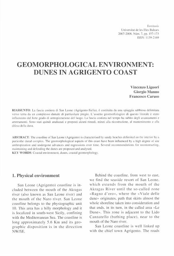
GEOMORPHOLOGICAL ENVIRONMENT: DUNES IN AGRIGENTO COAST
Vincenzo Liguori Giorg io M a n n o
Francesco Caruso
RIASSUNTO: La fascia costiera di San Leone (Agrigento-Siclia). è costituita da una spiaggia sabbiosa delimítala verso terra da un complesso dunale di particolare pregio. L'asset to geomorfologico di questo litorale è stato inlluenzato dal forte grado di antropizzazione del luogo. La fascia costiera nel tempo ha súbito degli avanzamenti e arreiramenti. Sono stati quindi analizzati e proposti alcuni rimedi. mirali alia ricostruzione. al mantenimenlo e alia diíesa della duna.
ABSTRACT: The coastline ol'San Leone (Agrigento) is characterised by sandy beaches delimited on the interior by a particular dunal complex. The geomorphological aspects of this coast nave been influenced by a high degree of site anthropization and undergone advances and regressions over time. Several recommendations for reconslructing. maintaining and defending the dunes are proposed and analysed. KEY WORDS: Coastal environmeiit. dunes, coastal geomorphology.
1. Physical environment
San L e o n e ( A g r i g e n t o ) coas t l i ne is in-c luded b e t w e e n the m o u t h of the A k r a g a s r iver (also k n o w n as San Leone river) and the m o u t h of t he N a r o r i v e r . S a n L e o n e coas t l ine be longs to the phys iograph ic unit 10. This área has a hilly morphology and it is local ized in sou th -wes t Sici ly . conf in ing with the Medi ter ranean Sea. The coast l ine is l o n g a p p r o x i m a t e l y 5.6 K m a n d i ts g é o g r a p h i e d i s p o s i t i o n is in t h e d i r e c t i o n N W / S E .
Behind the coast l ine . from west to east . we f ind the s e a s i d e r e so r t of San L e o n e , w h i c h e x t e n d s f r o m t h e m o u t h of t h e A k r a g a s R i v e r u n t i l t he s o - c a l l e d z o n e « R a g n o d ' o r o » . w h e r e t h e « V i a l e d e l l e dune» or iginates . path that skirts a lmost the whole shorel ine taken into considerat ion and that ends . in its turn. in the called área «Le D u n e » . T h i s z o n e is ad j acen t to the L i d o C a n n a t e l l o ( b a t h i n g p l a c e ) , n e a r to t he mouth of the Naro river.
San L e o n e c o a s t l i n e is we l l l i nked up wi th the ch ie f t o w n A g r i g e n t o . T h e r o a d s
Liguori, V.. Manno. G. y Caruso F. Geomorphological Environment: Dunes in.
that link up Agr igento with San Leone are: Francesco Crispi street, provincial road N°4 and E m p o r i u m avenue . In this t reatment . the coastal phys iographic unit has been chosen as t emtor ia l level of analysis . or rather that l i t t o ra l s t r ip in w h i c h the m o v e m e n t s of sediments are del imited and where there are n o e x c h a n g e s w i t h o t h e r a d j a c e n t
physiographic units. T h a n k s to this scale, it is p o s s i b l e to a n a l y s e in d e t a i l t h e deve lopment effects of the dynamics coastal .
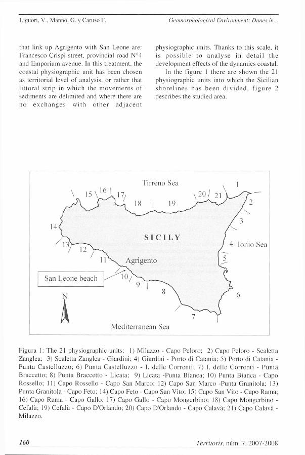
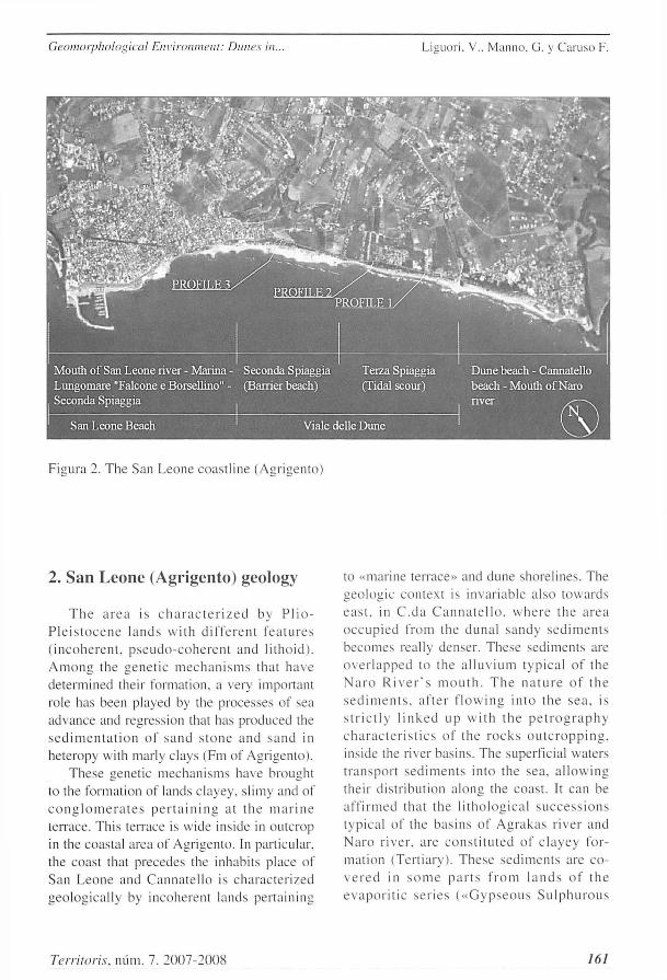
In the figure 1 there are s h o w n the 21 phys iograph ic units into which the Sici l ian s h o r e l i n e s h a s b e e n d i v i d e d . f i g u r e 2 descr ibes the studied area.
Figura 1: The 21 phys iographic units: 1) Milazzo - Cap o Peloro: 2) Cap o Peloro - Scaletta Zanglea : 3) Scaletta Zanglea - Giardini : 4) Giardini - Porto di Catania : 5) Porto di Catania -Pun ta C a s t e l l u z z o ; 6) Pun ta C a s t e l i u z z o - I. de l l e C o r r e n t i : 7) I. de l l e Cor ren l i - P u n t a Bracce t to : 8) Punta Braccet to - Licata: 9) Licata -Punta Bianca; 10) Punta Bianca - C a p o Rossel ló; 11) C apo Rossel ló - Capo San Marco ; 12) Cap o San Marco -Punta Grani tola ; 13) Punta Grani tola - Capo Feto; 14) Capo Feto - Capo San Vito: 15) Cap o San Vito - Cap o Rama; 16) Capo Rama - C apo Gal lo ; 17) Capo Gal lo - Capo Mongerb ino ; 18) C a p o Mongerb ino -Cefalü: 19) Cefalü - Capo D'Or lando; 20) Capo D'Orlando - Cap o Calava; 21) Cap o Calava -Milazzo.
160 Territoris, núm. 7. 2007-2008
Geomorphological Environment: Dunes in. Liguori, V.. Manno. G. y Caruso F.
Figura 2. The San Leone coast l ine (Agrigento)
2. San Leone (Agrigento) geology
T h e a r c a is c h a r a c t e r i z e d by P l i o -P l e i s t o c e n e l a n d s w i t h d i f f e r e n t f e a t u r e s ( i n c o h e r e n t , p s e u d o - c o h e r e n t and l i tho id) . A m o n g the genè t i c m e c h a n i s m s that have determined their formation, a very important role has been played by the processes of sea advance and regression that has produced the s e d i m e n t a t i o n of s a n d s t o n e and sand in heteropy with marly clays (Fm of Agrigento) .
These genètic mechan i sms have brought to the formation of lands clayey. slimy and of c o n g l o m e r a t e s p e r t a i n i n g at t he m a r i n e terrace. This t enace is wide inside in outcrop in the coastal area of Agrigento. In particular, the coast that precedes the inhàbils place of San Leone and C anna t e l l o is charac te r i zed geologica l ly by incoherent lands per ta ining
to «marine terrace» and dune shorelines. The geo lòg ic context is invar iable also towards c a s t . in C . d a C a n n a t e l l o . w h e r e the a r e a o c c u p i e d from the duna l s andy s e d i m e n t s becomes really denser. These sediments arc o v e r l a p p e d lo the a l l u v i u m typ ica l of the N a r o R i v e r ' s m o u t h . T h e n a t u r e o f t h e s e d i m e n t s , a f te r f l o w i n g i n t o the s ea . is s t r i c t l y l i n k e d u p w i t h t h e p e t r o g r a p h y c h a r a c t e r i s t i c s of the r o c k s o u t c r o p p i n g . inside the river basins. The superficial wàters t r anspor t s e d i m e n t s in to the sea . a l l o w i n g their dis t r ibut ion a long the coast . It can be a f f i rmed that the l i t ho log i ca l s u c c e s s i o n s typica l of the bas ins of A g r a k a s r iver and N a r o r iver , are c o n s t i t u t e d of c l a y e y format ion (Ter t ia ry) . These sed imen t s are co-v e r e d in s o m e p a r t s f r o m l a n d s of t h e e v a p o r i t i c s e r i e s ( « G y p s e o u s S u l p h u r o u s
Territoris, mim. 7. 2007-2008 161
Liguori, V.. Manno, G. y Caruso F. Geomorphological Environment: Dimes in.
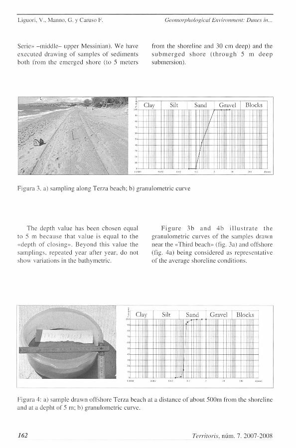
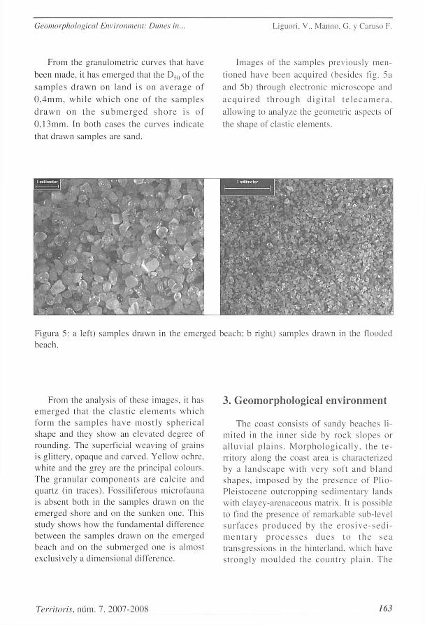
Serie» - m i d d l e - upper Messinian) . W e nave execu ted d r a w i n g of s ample s of s ed imen t s bo th from the e m e r g e d shore (to 5 me te r s
from the shoreline and 30 cm deep) and the s u b m e r g e d s h o r e ( t h r o u g h 5 m d e e p submers ion) .
T h e depth valué has been chosen equal to 5 m b e c a u s e that va lué is equa l to the «depth of c l o s i n g » . B e y o n d this va lué the s ampl ings . repeated year after year . do not show variat ions in the bathymetr ic .
F i g u r e 3 b a n d 4 b ¡ I l ú s t r a t e t h e g ranulomet r ic curves of the samples d rawn near the «Third beach» (fig. 3a) and offshore (fig. 4a) being cons idered as representa t ive of the average shorel ine condi t ions .
162 Territoris, núm. 7. 2007-2008
Geomorphologicaí Environment: Dunes in. Liguor i . V.. M a n n o . G. y C a r u s o F.
From the granulometr ic curves that have
been made . il luis emerged that the I),, o l ' lhe
s a m p l e s d r a w n on land is on a v e r a g e of
0 . 4 m m , w h i l e w h i c h o n e of t he s a m p l e s
d r a w n on t h e s u b m e r g e d s h o r e is of
0 , 1 3 m m . In both cases the curves indíca te
that drawn samples are sand.
Images of the samples previous ly men-
t ioned have been aequi red (bes ides fig. 5a
and 5b) through e lec t rònic mic roscope and
a e q u i r e d t h r o u g h d i g i t a l t e l e c a m e r a ,
a l lowing to analyze the geomètr ic aspeets of
the shape of elàstic e lements .
From the analysis of these images . it has e m e r g e d tha t t he e l à s t i c c l e m e n t s w h i c h fo rm the s a m p l e s h a v e m o s t l y s p h e r i c a l shape and they show an elevated degree of rounding. The superficial weav ing of grains is glit tery. opaque and carved. Yel low ochre . white and the grey are the principal colours . T h e g r a n u l a r c o m p o n e n t s are c a l c i t e and quar tz (in t races) . Fossi l i ferous microfauna is absent both in the samples d rawn on the emerged shore and on the sunken one. This study shows how the fundamental difference be tween the samples drawn on the emerged beach and on the s u b m e r g e d one is a lmost exclusively a d imensional difference.
3. Geomorphologicaí environment
T h e coas t cons is t s of sandy beaches li-mi t ed in the inner s ide by rock s l opes or a l · l u v i a l p l a i n s . M o r p h o l o g i c a l l y . the t e -rritory along the coast area is character ized by a l a n d s c a p e w i t h v e r y soft a n d b l a n d s h a p e s . i m p o s e d by the p r e s e n c e of P l io -P le i s tocene ou t c ropp ing s e d i m e n t a n 1 lands with c layey-arenaceous matrix. It is possible to fïnd the presence of remarkable sub-level s u r f a c e s p r o d u c e d by t h e e r o s i v e - s e d i -m e n t a r y p r o c e s s e s d u e s to t h e s e a t ransgressions in the hinterland. which have s t r o n g l y m o u l d e d the c o u n t r y p l a i n . T h e
Territoris, núm. 7. 2007-2008 163
Liguori, V.. Manno, G. y Caroso F. Geomorphological Environment: Dimes in.
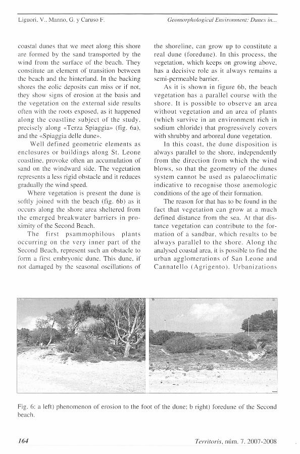
coastal dunes that we meet a long this shore are formed by the sand t ranspor ted by the w ind from the surface of the b e a c h . T h e y const i tu te an e lement of t ransi t ion be tween the beach and the hinter land. In the backing shores the eolic deposi ts can miss or if not. they show signs of erosión at the basis and the vege ta t ion on the ex te rna l s ide resu l t s often with the roots exposed . as it happened a l o n g the c o a s t l i n e s u b j e c t of the s t u d y . prec ise ly a long «Terza Sp iagg ia» (fig. 6a) , and the «Spiaggia delle dune» .
W e l l d e f i n e d g e o m è t r i c e l e m e n t s as e n c l o s u r e s or b u i l d i n g s a l o n g S t . L e o n e coast l ine . p rovoke often an accumula t ion of sand on the w indward side. The vegeta t ion represents a less rigid obstacle and it reduces gradual ly the wind speed.
Where vegeta t ion is present the dune is softly j o i n e d wi th the beach (fig. 6b) as it occurs a long the shore área shel tered from the e m e r g e d b r e a k w a t e r b a r r i e r s in p r o -ximity of the Second Beach.
T h e f i r s t p s a m m o p h i l o u s p l a n t s o c c u r r i n g on the v e r y i n n e r p a r t of t h e Second Beach. represent such an obstacle to form a first e m b r y o n i c dune . This dune . if not damasjed by the seasonal osci l lat ions of
the s h o r e l i n e . can g r o w up to cons t i t u t e a real d u n e ( f o r e d u n e ) . In th is p r o c e s s . Ihe vegetat ion. which keeps on g rowing above , has a dec i s ive ro le as it a l w a y s r e m a i n s a semi-permeable barrier.
As it is s h o w n in figure 6 b . the beach v e g e t a t i o n has a pa ra l l e l c o u r s e wi th the s h o r e . It is p o s s i b l e t o o b s e r v e an a r c a w i t h o u t v e g e t a t i o n and an á r ea of p l a n t s ( w h i c h s u r v i v e in an e n v i r o n m e n t r ich in sod ium ch lo r ide ) that p rogress ive ly c o v e r s with shrubby and arboreal dune vegetat ion.
In th i s c o a s t . t he d u n e d i s p o s i t i o n is a lways parallel to the shore , independenl ly f r o m the d i r e c t i o n f rom w h i c h the w i n d b l o w s , so that the g e o m e t r y of the d u n e s s y s t e m c a n n o t be u s e d as p a l a e o c l i m a t i c i n d i c a t i v e to r e c o g n i s e t h o s e a n e m o l o g i c condi t ions of the age of their formation.
The reason for that has to be found in the fact t ha t v e g e t a t i o n can g r o w at a m u c h def ined d i s tance from the sea. At that d i s tance vege ta t ion can con t r ibu te to the form a t i o n of a s a n d b a r . w h i c h r e s u l t s to b e a l w a y s p a r a l l e l to t he s h o r e . A l o n g t h e analysed coastal área, it is possible to find the u r b a n a g g l o m e r a t i o n s of San L e o n e a n d C a n n a t e l l o ( A g r i g e n t o ) . U r b a n i z a t i o n s
Fig. 6: a left) phenomenon of erosión to the foot of the dune; b right) foredune of the Second beach.
¡64 Territoris, núm. 7. 2007-2008
Geomorphological Environment: Dunes in. Liguorí, V.. Manno. G. y Caruso F.
(roads, piping systems. sewer systems. and so o n ) w h i c h s e r v e t h e s e s e t t l e m e n t s , h a v e caused the urgeney to créate along the coastal á rea a g rea te r n u m b e r of se rv ices (mar ina , hel iport . walk along the p romenade , and so on) which. t ime after t ime, have modil ied the dynamics of the natural processes, provoking in some strips of the shore. the moving back process of the coastl ine.
A l l of it h a s . as a c o n s e q u e n c e . t h e n e c e s s i t y of c a r r y i n g ou t w o r k s of p r o -tection. in order to secure the const ruct ions a sure safety. It p rovoked a progress ive dete-rioration of the coast . which has in the loss of m a n y d u n e s y s t e m s o n e of t h e m o s t a l a r m i n g s i g n á i s . T h e s e s y s t e m s . a l r e a d y t h r e a t e n e d by t h e g e n e r a l m o v i n g b a c k p r o c e s s of the c o a s t l i n e . have been par t ly
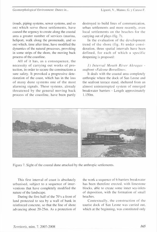
des t royed to build lines of c o m m u n i c a t i o n . urban se t t l emen t s and more recen t ly . even loca l s e t t l e m e n t s on the b e a c h e s for the carrying out of plays (fig. 7).
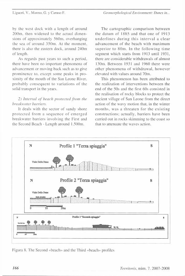
In t h e e v a l u a t i o n of the d e v e l o p m e n t t r e n d of t he s h o r e ( f ig . 8) u n d e r c o n s i d e r a r o n , th ree spat ia l in te rva l s have been d e f i n e d . for e a c h of w h i c h a s p e c i f i c deepening is proposed:
l) Interval Mouth River Akragas -seafront «Falcone-Borsellino».
It deals with the coastal area comple te ly anthropic where the dock of San Leone and the seafront terrace stand, sheltered from an a l m o s t u n i n t e r r u p t e d s y s t e m of e m e r g e d breakwate r barr iers - Length approximate ly 1.150m.
Figura 7. Sight of the coastal dune at tacked by the anthropic set t lements .
This first interval of coast is absolute ly u r b a n i s e d . sub jec t to a s e q u e n c e of in ter-vent ions that have comple te ly modified the nature of the landscape.
During the first half of the 70"s a front of land pro tec ted to sea by a wal l of bank in reinforced concre te , so that the line of shore advanc ing about 20-25m. As a protect ion of
the work a sequence of 6 barriers breakwater has been therefore e rec ted . with l imes tone b locks . able to créate some inner sea-inlets of depos i t i on . with the format ion of small beaches .
C o n t e x t u a l l y . the c o n s t r u c t i o n of the tourist dock of San Leone was carr ied out . which at the beginning, was consti tuted only
Territoris, mim. 7. 2007-2008 165
Liguori. V.. Manno. G. y Caruso F. Geomorphological Env'tronment: Dimes in.
by the west dock wi th a length of a r o u n d 2 0 0 m , then w i d e n e d to the ac tua l d i m e n sions of approx ima te ly 560m, ove rhang ing the sea of a r o u n d 3 5 0 m . At the m o m e n t , there is also the eastern dock, around 240m of length.
As regards past years to such a per iod. there have been no important phenomena of advancement or moving back such as to give p r o m i n e n c c to . excep t some peaks in pro-ximity of the mouth of the San Leone River. p r o b a b l y c o n s e q ü e n t to v a r i a t i o n s of t he sol id transport in the years .
2) Interval of beach protected from the breakwater barriers.
It dea l s with the sec tor of s andy shore p r o t e c t e d f r o m a s e q u e n c e of e m e r g e d b reakwate r barr iers involving the First and the Second Beach - Length around 1.500m.
T h e c a r t o g r a p h i c c o m p a r i s o n b e t w e e n the d a t u m of 1885 and that o n e of 1913 u n d e r l i n e s d u r i n g t h i s i n t e r v a l a o l e a r a d v a n c e m e n t of the beach wi th m á x i m u m s u p e r i o r t o 8()m. In t h e f o l l o w i n g t i m e segment which starts from 1913 until 1931, there are considerable wi thdrawals of almost 130m. Be tween 1931 and 1960 there were o the r p h e n o m e n a of w i t h d r a w a l . h o w e v e r elevated with valúes around 7()m.
This phenomenon has been attr ibuted to the real izat ion of intervent ions be tween the end of the 50s and the first 60s consisted in the realisation of rocky blocks to protect the ancient village of San Leone from the direct action of the wavy motion that, in the winter m o n t h s . w a s a t h r e a t e n for t he e x i s t i n g c o n s t r u c t i o n s ; ac tua l ly , bar r ie rs have been carried out in rocks sk imming to the coast so that to at tenuate the waves action.
N Profíle 2 "Terza spiaggia"
AJÍ V M c Delk Dunc
0 10 20m
Profíle 3 "Secónda spiaggian s
0 10 20m
Profíle 3 "Secónda spiaggian
1 1 1
Figura 8. The Second «beach» and the Third «beach» profiles
166 Territoris, núm. 7. 2007-2008
Géomorphological Environment: Dunes in. Liguori. V.. Marino. G. y Caruso F.
However . this intervention has caused an i m b a l a n c e of the c o a s t l i n e d y n a m i c s p re -venting the taking in load of the sandy material to t ransport towards East and so the in-c r ea se of the e r o s i v e po ten t i a l of the sea , w h i c h g a t h e r e d in t h e a d j a c e n t c o a s t a l wàters .
The fol lowing intervent ions through the c o n s t r u c t i o n of the d o c k and the sea f ron t prevented the dispersión towards East of the sòlid deposi ts der iving from the San Leone R i v e r a n d h a v e e v e n m o r e a c c e n t e d t he erosive power of the sea: to these effects it m u s t b e a d d e d t h o s e d e r i v i n g by t h e intervent ions of reclamat ion inside the basin of the San Leone river, actually ex tended to the first 90s . consis tent in the realization of harness ing and cemen t ing of many s t reams tributaries in the principal water course . able to limit the natural capacity of the river sòlid transport . In the fol lowing years . part of the « tombolo» shore has been comple te ly covert by new coastal deposi ts and dur ing the last p e r i o d it is r e c o r d e d the t e n d e n c y to the formation of new small dunes fronts.
T h e a c t u a l t r e n d is t h e r e f o r e t h a t of p reva len t s t a t i ona r ine s s . wi th a por t ion of s h o r e in w h i c h a r e m a r k a b l e q u a n t i t y of sed iments t rapped by the barriers results to be subtracted to the dynamics of the sea. The c o m p a r i s o n a m o n g the d a t a of 1931 and 1998 shows , as a matter of fact. a prevai l ing a d v a n c e m e n t of the coas t l iné , ar t i f ic ia l ly imposed by the breakwaters .
. í ) Intervallo di spiaggia libera «Viale delle Dune» - Cannatello.
It d e a l s w i t h t h e s e g m e n t of s h o r e vvi thout p r o t e c t i o n . e x t e n d i n g f r o m t h e o r t h o g o n a l g r o i n . w h i c h d e l i m i t s t h e protected shore close to the third traverse of the Viale delle Dune . up to the mouth of the River Naro - Length approximate ly 2 .650m.
The p h e n o m e n o n of urbanisa t ion of the wes te rn coas ta l part has c a u s e d . na tura l ly , the increase of erosive processes on the East
coas ta l wà t e r s , e x p o s i n g the part of beach free f rom the b r e a k w a t e r b a r r i e r s to the e r o s i v e a c t i o n o f t h e w a v y m o t i o n , so evident during the last years .
The strip under examinat ion is included a m o n g the end of the p r o t e c t e d sho re (in p r o x i m i t y of the th i rd c r o s s r o a d ) and the m o u t h of the N a r o R ive r (in p r o x i m i t y of C a n n a t e l l o B e a c h ) for a l eng th of a r o u n d 2.650 meters .
Also for this sector of shore . feed mainly d e r i v e s f r o m s ò l i d d e p o s i t s f rom t h e A k r a g a s r i v e r a n d f rom the s m a l l i n t e r -m e d i a t e d e e p va l l eys that f low a long this l ine of c o a s t . wi th the s e d i m e n t s ' d i s p l a c e m e n t. g a r a n t e e d by t h e d r i f t c o a s t a l current facing East.
Obv ious ly . for the reasons above listed. the evolut ion of this coast l ine is exclusively l inked up to the modi f i ca t ions occur red in the western shore.
The first compar i son be tween 1885 and 1913 u n d e r l i n e s a m a r k e d w i t h d r a w a l in proximity of Cannate l lo Beach . where there are peaks also of around 8()m. the remaining part of this sho re l ine is ins tead subject to advancement s not over 20m in proximity of the third beach and wi thd rawa l s of a round lOm in proximity of the beach of Dunes . In the p e r i o d a m o n g 1913 and 1931 fu r the r s ignif icant var ia t ions of the shore l ine have been r e c o r d e d . S h o r e l i n e k e e p s on g o i n g backwards in proximity of the zone a m o n g Cannate l lo Beach and the mouth of the Naro river. with peaks just a little over 9 0 m . whi le t h e a d v a n c e m e n t s a r e a r o u n d 5 0 m in proximity of the third beach. Eventual ly , no mean ingfu l va r i a t i ons h a v e been found in the shorel ine related to the beach of Dune .
In the compar i son a m o n g 1931 and 1966 a p o s i t i v e t r e n d of t h e b e a c h c a n be under l ined . with a average advancemen t of a r o u n d 10 m e t e r s a s s o c i a t e d w i t h t h e w i thd rawa l of the wes te rn sector , with the d isp lacement of the coastal deposi ts towards E a s t . T h e n e g a t i v e d a t u m is r e c o r d e d
Territoris, núm. 7. 2007-2008 /f57
Liguori, V.. Manno, G. y Caruso F. Geomorphological Environment: Dimes in..
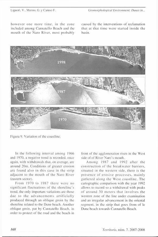
h o w e v e r o n e m o r e t i m e , in t h e z o n e inc luded a m o n g C anna t e l l o Beach and the moLith o í the N a r o R ive r , most p r o b a b l y
caused by the in te rvent ions of rec lamat ion that at tha t t i m e w e r e s t a r t e d i n s i d e t h e basin.
Figura 9. Variat ion of the coast l ine.
In the f o l l o w i n g in t e rva l a m o n g 1966 and 1970. a negat ive trend is recorded. once again. with wi thdrawals that. on average . are a round 20m. C o n d i t i o n s of grea ter e ros ión a r e f o u n d a l s o in t h i s c a s e in t h e s t r i p a d j a c e n t to the m o u t h of the N a r o R i v e r (eastern sector) .
F r o m 1 9 7 0 to 1 9 8 7 t h e r e w e r e n o s ign i f i can t f l uc tua t i ons of the s h o r e l i n e ' s trend. the only important variat ions are those d u e to t h e a d v a n c e m e n t s a r t i Fi c i a 11 y p r o d u c e d th rough an ob l i que groin by the shorel ine related to the Dune beach. Another obl ique groin. put by Canna te l lo Beach . in order to protect of the road and the beach in
front of the agglomera t ion risen in the West side of of River N a r o ' s mouth.
A m o n g 1 9 8 7 a n d 1 9 9 2 a f t e r t h e c o n s t r u c t i o n of the b r e a k w a t e r b a r r i e r s , s i t u a t e d in the w e s t e r n s i d e . t h e r e is the p r e s e n c e of e r o s i v e p r o c e s s e s , m a i n l y g a t h e r e d a l o n g t h e W e s t c o a s t l i n e . T h e car tographic compar i son with the year 1992 a l lows to record so a wi thdrawal with peaks of a r o u n d 3 0 m e l e r s t h a t i n v o l v e s t h e western zone of the line under examinat ion and an irregular advancement in the oriental s e g m e n t , in the s t r ip that g o e s from of le Dune beach towards Cannate l lo Beach.
168 Territoris, núm. 7. 2007-2008
Geomorphologicaí Environment: Dunes in. Liguori. V.. Manno. G. y Caruso F.
In t ime this permanent situation keeps on worsen ing and the compar i son with the 1998 c a r t o g r a p h y p u t s in e v i d e n c e a f u r t h e r wi thdrawal situated in the most western part, with a reduct ion of the beach of around 30m. a further peak is also recorded in proximity of t he D u n e b e a c h wi th a w i t h d r a w a l of around 4 0 m .
D u r i n g the last yea r s , the z o n e of free beach has been subject to heavy flood that have subsequent ly provoked the wi thdrawal of the shore in part icular in the western área. T h e eros ión is mani fes ted both agains t the n a t u r a l s t r u c t u r e of t he b e a c h , s e r i o u s l y a t t ack ing and d a m a g i n g in m o r e s t r ips the d u n e , both aga ins t the an th rop ic s t ruc tures carried out in the immedia te vicinity of the back beach , with ser ious d a m a g e s . even if they are yet located. on the road for «Viale delle Dune» .
In conclus ión , the under waves zone next to the anthropic intervent ions. which consist in the b r e a k w a t e r b a r r i e r s pa ra l l e l to t he c o a s t l i n e , n o w a d a y s is sub j ec t to i n t e n s e e r o s i v e p h e n o m e n a . A l o n g t h i s s t r i p of s h o r e . t h e r e w a s a d u n e a n d r e t r o - d u n e s t ruc tu r e in e q u i l i b r i u m , c h a r a c t e r i z e d by t y p i c a l v e g e t a t i o n of t he M e d i t e r r a n e a n b u s h . c o n s o l i d a t i n g the s a m e d u n e . T h e increase of the erosive process has p rovoked the t a p e r i n g of th i s p o r t i o n of coas t á r ea which separated Viale delle Dune from the shore l ine . In par t icular , from the budget of the sed iments a long this shore is absent the br inging due to the beaches protected by the e m e r g e d b r e a k w a t e r b a r r i e r s . w i t h c o n s e q ü e n t i n t e n s i f i c a t i o n of t he e r o s i ó n near the á reas not p ro t ec t ed . M o r e o v e r . it must be added the fact that in the two basins related to the courses of water f lowing along the shore, intervent ions of reclamation have been carried out until the first 9 0 ' s , such as h a r n e s s i n g m a n y a f f l u e n t s t r e a m s to t he p r inc ipa l w a t e r c o u r s e s and even ar t i f ic ia l obs t ruc t ions that have definitely l imited the na tu r a l c a p a c i t y of sò l id t r a n s p o r t of the
r ivers , wi th fur ther nega t ive c o n s e q u e n c e s on the budget of the sed iments . All of this has caused not only the w i thd rawa l of the coast l ine, but also the conseqüent erosión of the dune at the back. which has the function of «natural reserve of sand» for the before beach . and which has been more and more tapering until to fade away .
4. Considerations on the defence of the Dune System
T h e e r o s i v e p h e n o m e n o n a l o n g t h i s s h o r e has a r o u s e d in the y e a r s p a r t i c u l a r a t tent ion and interest the c o m m u n i t y . as it has p rovoked the parda l des t ruc t ion of the c o a s t a l d u n e . t ha t r e p r e s e n t s o v e r tha t a natural s t ruc ture of pa r t i cu l a r in teres t and merit under the env i ronmenta l profile. geo-m o r p h o l o g i c . l a n d s c a p e p r o f i l e . a l s o an essential barrier to protect what is situated in p r o x i m i t y of it ( r o a d s . i n h a b i t e d p l a c e s , agricultural g rounds . etc.) . The restoration or the recons t ruc t ion of a t o m b o l o and of the r e l a t i ve e c o s y s t e m can c e r t a i n l y h a v e no o the r pu rpose if not the res to ra t ion of the naturalness . A project of reconstruct ion can i n v o l v e b o t h t h e r e i n f o r c e m e n t o f a n exist ing natural dune or in height or in depth and the reconstruct ion of a dune whereas it d o e s not exis t a n y m o r e . T h e best work of r e d e v e l o p m e n t is a lways ach ieved th rough the r e c o n s t r u c t i o n of b e a c h e s a n d d u n e s similar as much as possible to those original . The dune bars face the great t ides of s torm. p r even t the a p p r o a c h i n g of the big w a v e s and they prevent directly the damage of the works si tuated along the coast and the flood of the inner zones .
The growth of the dune can be p rometed and its s tructure can be s t rengthened against the e ros ión if it s u c c e e d s in m a k i n g g r o w a p p r o p r i a t e v e g e t a t i o n on i t . d u r i n g an adequate period with the purpose to have a we l l d e v e l o p e d rad ica l a p p a r a t u s . For the
Territoris, núm. 7. 2007-2008 169

Liguor i . V.. M a n n o . G. y C a r u s o F. Geomorphologicaí Environment: Dunes in..
phytostabi l isat ion it is possible to use local and s h r u b b y h e r b a g e . H o w e v e r , the re fo-r e s t a t i o n of t h e d u n e s is no t a s i m p l e operat ion. as the subst ra tum is in cont inuous e v o l u t i o n and the r o o t s of the n e w l i t t le plants are cont inual ly exposed by the wind. It is then necessary to make them stable with dead hedges or with nets and panels before p r o c e e d i n g to the i r p l an t ing . E x a m p l e s of this type of i n t e rven t ions can be o b s e r v e d both in Italy and in the test of the world and t h e y s h o w a g rea t v a r i e t y of t y p o l o g i e s . w h i c h c o n v e r g e g e n e r a l l y in b e d d i n g Ammophila.
T h e spec ie s m o r e used are Ammophila littoralis (A. breviligulata in A m e r i c a ) or, a long the Atlantic coasts . Unióla paniculata, Panicum amanim, Panicum amaruliim. The p l a n t s m u s t t o b e b e d w i t h g r e a t c a r e , cover ing them almost entirely with sand. so that the plant can have an eas ier access to the d a m p and it can be protec ted from the bar ing of the wind and from the s t amping ; s e p a r a t e l y o r in g r o u p s at a d i s t a n c e of around 50cm.
It is better to resort to the t ransplantat ion. instead of the seeding: besides the difficulty to find the s e e d s . in l'act, it wou ld be nece s sa ry an e x c e s s i v e i r r iga t ion . W h e n the s a n d is t r a p p e d by p l a n t s c o l l o c a t e d t o o c ióse , a dune wi th na r row base g r o w s ; on the other hand, if the same number of plants is set w i th sma l l d e n s i t y . the b a s e of the dune will result wider. When the Ammophila are planted too close it is very difficult the reclamation of other dune species .
It is important to specify that this system d o e s not w o r k a n y w h e r e . but on ly w h e r e there is enough dynamics to build. that is in other words where there is a good bringing of sand, o therwise the dune can form and the plants of Ammophila decay. Another problem is that Ammophila vegeta tes with difficulty unless it is at Ieast 2 m above sea level.
It must be expec t from 2 to 5 years so that the Ammophila c r ea te s a s t rong roots
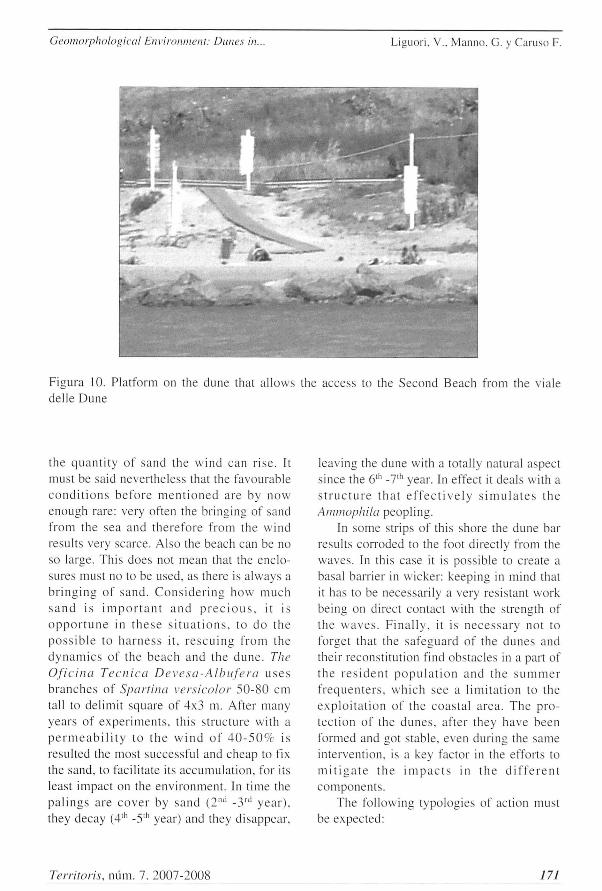
appara tus , and up to 10 years before gett ing the m á x i m u m resistance against the erosión. An a c t i v e p r o g r a m of e n r i e h m e n l a n d m a i n t e n a n c e o f t h e v e g e t a t i o n c a n cons ide rab ly improve the surv iva l and the e f f i c acy of t he Ammophila. M o r e r e c e n t e x p e r i e n c e s u s e a l s o o t h e r s p e c i e s : p a r -t i c u l a r l y it r e s u l t s u s e í u l t h e Otanthus maritimus, tha t b e a r s the a e r o s o l and the sprays very well and it has a good edifying c a p a b i l i t y . It is e v i d e n t t ha t t h e s e in t e r vent ions need the preciusion to the access , at l eas t up to the m o m e n t in w h i c h the v e g e t a t i o n has not c o m p l e t e l y c o v e r e d the dune : precius ion that is achieved by means o f t h e c o n s t r u c t i o n o f e n c l o s u r e s o r in a l t e r n a t i v e s u p e r e l e v a t e p a t h s o r w o o d p l a t f o r m s (fig. 10) so that the p a s s a g e of people do not p roduce a furrow which the wind could then deepen and widen.
Another methodology that can be used is t h e « c o n s t r u c t i o n of t h e d u n e s t h r o u g h e n c l o s u r e s » . T h e s e e n c l o s u r e s a r e c o n s -t i t u t e d by w o o d s t i c k s or b r u s h w o o d , o r f rom p làs t i c s t r uc tu r e s or m e s h of j u t a or coconut fibre. W e can proceed by install ing a single fence, with following raisings of a single row, after the first one has been filled; or with a double row of fences. spaced out of l 'our t i m e s t h e h e i g h t . f o l l o w e d by ra i s ings a lso cons t i tu t ed by a d o u b l e Iine. T h e enc lo su re s ' porosi ty has to be of 50c/c with empty and full spaces of 5 cm: they can be submerged even in one year.
H o w e v e r . s a n d ' s a c c u m u l a t i o n v a r i e s a c c o r d i n g to the s e a s o n . the yea r and the locat ion: under favourable cond i t ions sand r i ses of 1-2 m gene ra l l y in one year . T h e enclosures have the vantage that they can be set in any season of the year ant they start i m m e d i a t e l y to hold the s a n d . w h i l e it is necessary to wait that vegetat ion takes root and g rows sufficiently. the wideness of the beach has the great influence on the speed of accumula t ion: it is evident that the wider is the surface before the barrier. the greater is
170 Territoris, núm. 7. 2007-2008
Geomorphological Environment: Dunes in. Liguori, V.. Manno. G. y Caruso F.
the q u a n t i t y of sand the w ind can r i se . It must be said never theless that the favourable c o n d i t i o n s b e f o r e m e n t i o n e d a re by n o w enough rare: very often the br inging of sand from the sea and the re fore from the wind results very scarce. Also the beach can be no so large. This does not mean that the enclo-sures must no to be used, as there is a lways a b r i n g i n g of s and . C o n s i d e r i n g h o w m u c h s a n d is i m p o r t a n t a n d p r e c i o u s . it is o p p o r t u n e in t h e s e s i t u a t i o n s . to d o t he p o s s i b l e to h a r n e s s it. r e s c u i n g from the d y n a m i c s of the b e a c h and the d u n e . The Oficina Técnica Devesa-Albufera u s e s b r a n c h e s of Sparlina versicolor 5 0 - 8 0 cm tall to delimit square of 4x3 m. After many years of e x p e r i m e n t s , this s t ruc ture with a p e r m e a b i l i t y to t h e w i n d of 4 0 - 5 0 7 r is resulted the most successful and cheap to fix the sand, to facilítate its accumula t ion . for its least impact on the envi ronment . In t ime the p a l i n g s are c o v e r by s a n d ( 2 " d - 3 r d y e a r ) . they decay ( 4 l h -5 ' 1 ' year) and they disappear .
leaving the dune with a totally natural aspect since the 6"' -7" 1 year. In effect it deals with a s t r u c t u r e t h a t e f f e c t i v e l y s i m ú l a l e s t h e Amtnophila peopl ing.
In some strips of this shore the dune bar results corroded to the foot directly from the waves . In this case it is possible to créate a basal barrier in wicker : keeping in mind that it has to be necessari ly a very resistant work being on direct contact with the strength of t he w a v e s . F i n a l l y . it is n e c e s s a r y not to forget that the sa feguard of the d u n e s and their reconst i tut ion find obstacles in a part of t he r e s i d e n t p o p u l a t i o n a n d the s u m m e r f r e q u e n t e r s . w h i c h see a l imi ta t ion to the e x p l o i t a t i o n of the coas t a l á rea . T h e p ro -tec t ion of the d u n e s , after they have been formed and got stable, even during the same intervention. is a key factor in the efforts to m i t í g a t e t h e i m p a c t s in t h e d i f f e r e n t componen t s .
The fol lowing typologies of action must be expected:
Territoris, núm. 7. 2007-2008 171
Liguori, V.. Manno, G. y Caruso F. Geomorphological Environment: Dimes in.
1) physical protect ion, that involves the reparat ion of the fences and the main tenance of t h e v e g e t a t i o n . I n t e r r u p t i o n s of t h e enc lo su re inc rease the p robab i l i ty that the dune is damaged by the erosión of the wind and by the passage of the people :
2) l ega l p r o t e c t i o n . that i n e l u d e s t he pos s ib i l i t y to a d o p t s o m e o r d i n a n c e s that g ive to the corporate bodies in charge of the a r r a n g e m e n t of the d u n e s the au thor i ty to regúlate the a l lowed and forbidden activit ies in the área of the dunes and to clearly define the áreas of dune and beach. The municipal pólice, the coas tguard . the beach-a t tendants will provide to m a k e o rd inances respected. T h e v i o l a t i o n s w i l l b e s e t t l e d w i t h adminis t rad ve sanct ions;
3) p r o g r a m s of e d u c a t i o n a n d s e n s i -tization to increase the awareness about the i m p o r t a n c e o f t h e d u n e s a s n a t u r a l p r o t e c t i o n . It is f u n d a m e n t a l t h e c o n s -truction of supere levate g a n g w a y s in wood or of pedestr ian paths pleasantly pract icable to cross the dune and to reach the beach. to a v o i d the s t a m p i n g of the d u n e s á r ea s so i n t e n s e l y f r e q u e n t e d : in faet . p e o p l e use them with pleasure because walk ing on the s a n d is v e r y t i r i n g . In t h i s w a y t h e e n v i r o n m e n t a l p r o b l e m is r e s t r i c t e d in l i m i t e d á r e a s w h e r e t h e d a m a g e o f t h e vegeta t ion and the eros ión of the dune are prevented by technical devices .
5. Conclusión
The study has paid part icular ev idence to t h e p r o b l e m s l i n k e d u p to t he e r o s i v e p h e n o m e n o n ( w i t h d r a w a l of the sho re l i ne wi th c o n s e q ü e n t d e s t r u c t i o n of the d u n e ) with the purpose not only to find its causes bu t a l s o of g e t d u r a b l e a n d e f f e c t i v e so lu t ions . T h e c a u s e s resul l very c o m p l e x and art iculated, but, a m o n g these. there are cer ta inly the uncont ro l led urbanisa t ion and t h e n e g a t i v e b u d g e t o f t h e s e d i m e n t s
b r o u g h t by t he t w o r i v e r s ( A k r a g a s and Naro) that flow on the shorel ine. The trend of the coastal evolut ion has been establ ished taking into considerat ion the most important modif icat ions of anthropic origin imposed to the coast l ine and its important variat ions in the long term and in the short period.
W e h a v e s t u d i e d a l s o t h e e s t e e m e d ecosys tems in site which . according to what h a s b e e n p r e v i o u s l y s a i d . are t h e s e d a y s threatened by the erosión and by the wrong h u m a n b e h a v i o u r s . t h a t w i t h e x c e s s i v e c a r e l e s s n e s s has ignored them up to n o w . vvi thout t a k i n g i n t o a c c o u n t h o w m a n y advantages derive from the «good health» of such natural s tructures. Finally we have also a n a l y z e d p o s s i b l e r e m e d i e s , a i m e d to the r e c o n s t r u c t i o n . the m a i n t e n a n c e a n d the defence of the dune . propos ing a sustainable use of the dunes ecosys tem.
6. Acknowledgement
W i t h t h e c o n t r i b u t i o n of t he C o . R . I . 2007 . Universi tà degli Studi di Pa le rmo
Bibliography
A A . V V . ( 1 9 9 9 ) : Toward an European strategy for the coastal zones Management ( G I Z C ) . G e n e r a l p r i n c i p i e s and po l i t i c a l opt ions
A G E N C . A G E N C E P O U R L A G E S T I Ó N D E S E S P A C E S N A T U R E L S D E C O R S É ( 1 9 9 4 ) . Restauration de dimes a faible dynamique edificatrice en Corsé. Bastia. Inedited.
A J U N T A M E N T D E V A L E N C I A y D E V E S A D E L ' A L B U F E R A ( 2 0 0 0 ) . Restauración de las dunas litorales de la Devesa de la Albufera de Valencia.
A J U N T A M E N T D E V A L E N C I A . LIFE ( 2 0 0 3 ) . Duna, modelo de restauración de habitats aunares en I'albufera de Valencia.
172 Territoris, mim. 7. 2007-2008
Geomorphological Environment: Dunes in. Liguori. V.. Matino, G. y Caruso F.
A N F U S O . G. y M A R T Í N E Z . J. A . . ( 2 0 0 5 ) : T o w a r d s m a n a g e m e n t of c o a s t a l e r o s i ó n p r o b l e m s a n d H u m a n s t r u c t u r e s i m p a c t s u s i n g G I S t o o l s : c a s e s t u d y in R a g u s a p r o v i n c e , s o u t h e r n S i c i l y . I t a l y . Enviromental geology, 48 : 646-659 .
A N N U A R I O DEI DATI A M B I E N T A L I S I C I L I A (2004) : Agenz i a Reg iona le per la Protezione delí ' Ambiente - Regione Siciliana - Assessorato Terri torio e Ambiente .
A U D I S I O . P. y M U S C I O . G. ( 2 0 0 2 ) : Problemi di conservazione e gestione, in Dune e spiagge sabbiose. Quaderni Habitat . Minis tero de l l 'Ambien t e & Museo Friulano di Storia Natura le . Udine .
C O C O S S I S . H . y H E N O C Q U E , Y . ( 2 0 0 I ) : Wlüte paper, coastal zones management in the Medilerranean. Communica t i on of the European Commi t t ee (08 .09 .2000 N.545 DEF) . Recommenda t ion of the European Parl iament to the suggest ion re la ted to the rea l iza t ion of the in tegra ted managemen t of the coastal zones in Europe .
C O M M I S S I O N E U R O P E E N N E . P R O -G R A M M E O P E R A T I O N N E L I N T E R R E G III B ( 2 0 0 3 ) : Le projet Beachmed: rècupèration environnementale et entrenen des littoraux en erosión avec l'utilisation des dèpots sablonneux marins. Conven t ion 2 0 0 3 - 0 1 - 4 . 3 - 1 - 0 2 8 . I o C a h i e r t e c h n i q u e (phase A) .
C R O W E L L . M.. L E A T H E R M A N . S. P. y B U C K L E Y . M . K. ( 1 9 9 3 ) : S h o r e l i n e Change Rate Analys is : Long Term Vs. Short Te rm Data. Shore and Beach, 61(2) . 13-20.
D O M Í N G U E Z . L . . A N F U S O . G. y G R A C I A . F. J . ( 2 0 0 5 ) : V u l n e r a b i l i t y a s s e s s m e n t of a r e t r e a t i n g c o a s t in S W Spain . Environmcnlal Geology. 4 7 . 10-37-10-44.
L I G U O R I , V.. A N F U S O . G.. M A N N O . G . . C I N T O L O . R. y M A R T Í N E Z D E L P O Z O J. A . ( 2 0 0 6 ) : Vulnerability assessment of a coastal sector in south Sicily (Italy) in 5° European Congress on Regional Geofscientif ic Car tography and Information S i s tem. (Vol . 1. pp. 5 1 0 - 5 1 2 ) . 13-16 June .
B a r c e l l o n a : I n s t i t u t C a r t o g r à f i c t he Cata logna (Spain) .
L I G U O R I . V.. A N F U S O . G.. M A N N O . G . . C I N T O L O . R. y M A R T Í N E Z D E L P O Z O J. A. (2006) : Asse s smen t of coastal v u l n e r a b i l i t y in s o u t h S i c i l y ( I t a l y ) . In: M i c a l e f f A . V a s s a l l o A . . C a s s a r M . Management of coastal recreational resources, Beaches. Yacht Meninas & Coastal ecotourism. ( V o l . l . p p . 1 2 5 - 1 3 2 ) . I S B N : 9 9 9 3 2 - 6 5 0 - 9 - 8 . T h e s e c o n d I n t e r n a t i o n a l C o n f e r e n c e on the M a n a g m e n t of coas t a l e c o t o u r i s m 2 5 - 2 7 O c t o b e r . ( I C o D ) G o z o : (Malta).
L I G U O R I . V. y M A N N O . G. ( 2 0 0 6 ) : I n t a g r a t e d m a n a g e m e n t of M a r s a l a c o a s t (Sici ly- Italy). In: Micaleff A. Vassa l lo A.. C a s s a r M . Management of coastal recreational resources, Beaches, Yacth Marinas & Coastal ecotourism. ( V o l . l . pp . 1 2 5 - 1 3 2 ) . I S B N : 9 9 9 3 2 - 6 5 0 - 9 - 8 . T h e s e c o n d I n t e r n a t i o n a l C o n f e r e n c e on the M a n a g m e n t of c o a s t a l e c o t o u r i s m 2 5 - 2 7 October . ( ICoD) Gozo : (Mal ta) .
L I G U O R I . V. y A N F U S O . G. ( 2 0 0 5 ) : L a n d f o r m c h a r t e r i s t i c s and the i m p a c t of h u m a n s t r u c t u r e s on t he c o a s t a l a r e a of Pozza l lo (south Sici ly. I taly). Ecosud 2005 Fifth international conference of ecosistems and sustainable development 3 -5 M a y . Cadiz Spain.
M I C A L L E F . A . y W I L L I A M S . A. T . (2004): Application of to novel approach lo beach classification in Maltese Islands. Elsevier.
M O O R E . L. (2000) : Shore l ine mapp ing t echn iqu ie s . Journal Coastal Research. 16 (1). 1 1-124.
P I N A R D I . N. y C O P P I N I . G. ( 2 0 0 6 ) : Mediterraneau Operational Oceanography Network (MOON): in support of sustainable development and marine state assessment. I N G V . Bologna and E N E A . La Spezia.
R I N A L D I . A. A R P A Emi l i a R o m a g n a «La gest ione integrata delle zone cost iere in Emi l i a -Romagna» , Emilia - R o m a g n a .
Territoris, mim. 7. 2007-2008 77.?