the heritage of Lombardy's canals
48
THE HERITAGE OF LOMBARDY’S CANALS World Canals Conference Milan 1 - 4 Sept. 2014 Claudio Repossi Navigli Lombardi
-
Upload
claudio-repossi -
Category
Travel
-
view
168 -
download
2
Transcript of the heritage of Lombardy's canals

THE HERITAGE OF LOMBARDY’S CANALS
World Canals Conference Milan 1 - 4 Sept. 2014
Claudio Repossi Navigli Lombardi
2
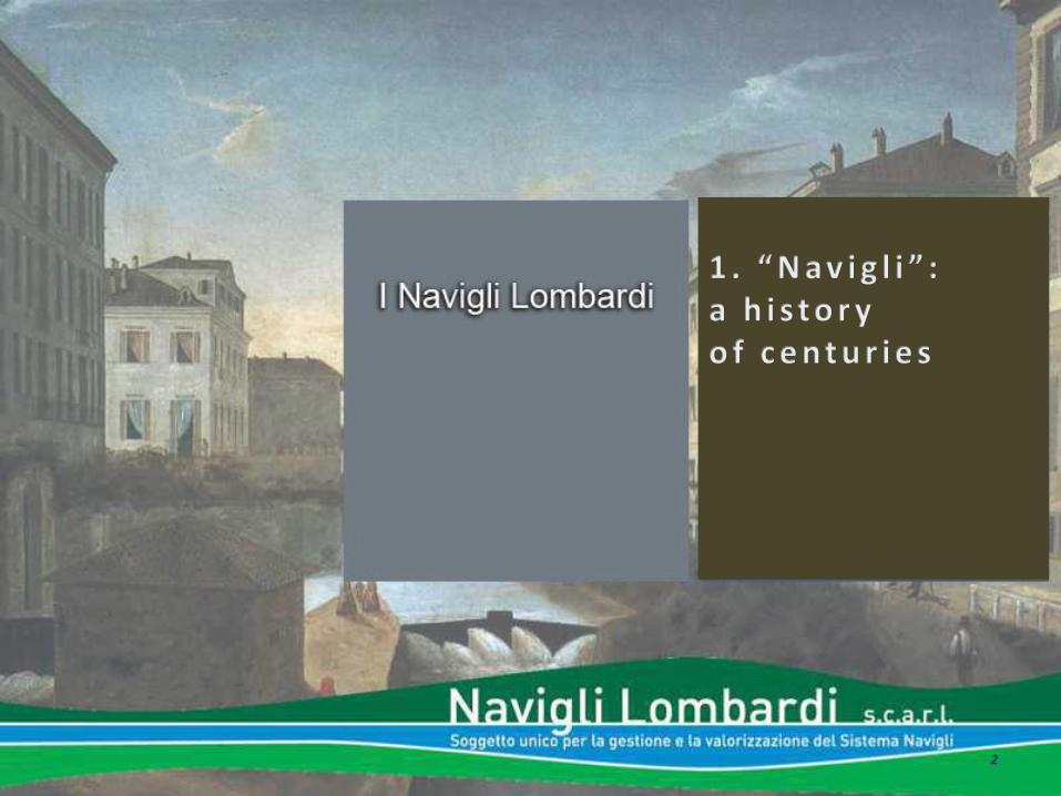
The Navigli system
Naviglio Grande
Naviglio Martesana
Naviglio Pavese Naviglio di Bereguardo
Naviglio di Paderno
3
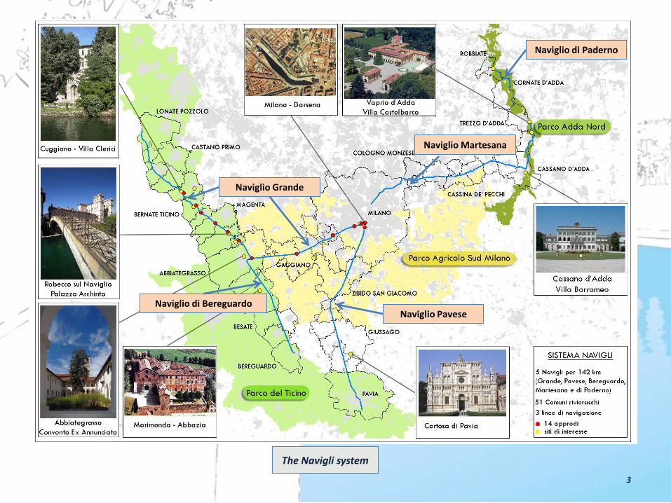
history The history of the Lombard Canals or “Navigli” is long and varied
and goes back as far as the 12th Century with the groundwork
for the construction of the Naviglio Grande (1179) and come to
an end in 1819 with the confluence of the Naviglio Pavese into
the River Ticino.
Contributions have been made over the centuries by the Visconti and
Sforza Houses of Milan, Leonardo da Vinci, Maria Theresa of Austria
and Napoleone Bonaparte.
The canals are: Naviglio Grande (1179), Naviglio di Bereguardo (1457), Naviglio Martesana (1463), Naviglio Pavese (1819) and Naviglio di Paderno (1516-1777).
Heritage
4

It was in Milanese area , in the twelfth century, that
the Benedictines carried out the first "environmental
redevelopment plan" in Europe, using the water of the
springs and rationalizing its use.
The development of agricultural production through
more extensive irrigation in that part of the territory
affected by the phenomenon of resurgence, the chance
to reclaim the many wetlands and not least the
substantial economic benefits from the ability to
leverage the transport of goods by water aroused soon
the interest of the State of Milan. Since the Middle
Ages, it took its own resources to build a system of
canals, “Navigli”, which crosses the whole territory and
to guarantee the capital Milan easy connections
through the rivers Ticino and Adda located
respectively, to the west and east of the city, to areas
characterized by intense trade as Switzerland, the
Valtellina and Pavia in the north and south of the river
Po
Ambone di Sant’Ambrogio, part., Milano, Basilica di Sant’Ambrogio Stemma dei Torriani, XIII sec.,
Heritage
5
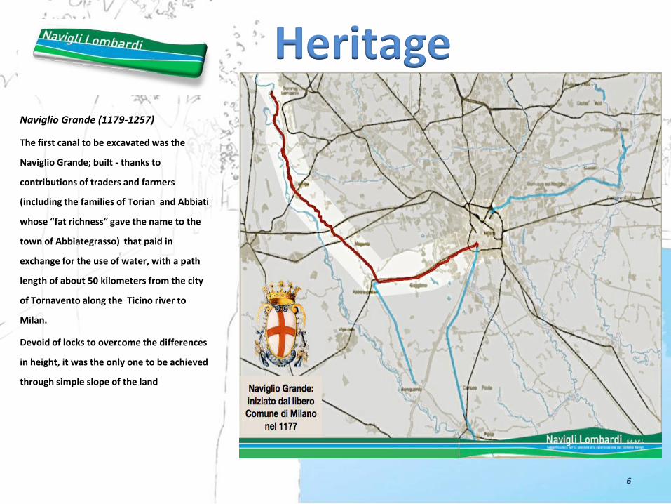
Naviglio Grande (1179-1257)
The first canal to be excavated was the
Naviglio Grande; built - thanks to
contributions of traders and farmers
(including the families of Torian and Abbiati
whose “fat richness“ gave the name to the
town of Abbiategrasso) that paid in
exchange for the use of water, with a path
length of about 50 kilometers from the city
of Tornavento along the Ticino river to
Milan.
Devoid of locks to overcome the differences
in height, it was the only one to be achieved
through simple slope of the land
Heritage
6

Domenico Aspari, La città assediata dall’Imperatore Federico Barbarossa nel 1157, in A. Fumagalli, Le vicende di Milano, 1778, Milano, Civica Raccolta Stampe Bertarelli
Heritage
It was build in three steps:
• the first till the city of Trezzano in
1187,
• the second in 1211, to the gates of
Milan at the Bridge of S. Eustorgio in
1253 up to Gaggiano,
• the third was built in 1257 and placed
permanently in communication with
the Verbano and the Ticino area and
the city of Milan.
In 1272 the canal was crossed by boats
carrying timber, hay, cheese, livestock,
marble and granite, salt, iron, grain
and miscellaneous manufacturing.

“Milano nei secoli bassi”, Milan 1878, Civica Raccolta Stampe Bertarelli
Heritage
8

Naviglio Martesana (1457-1463)
In the second half of the fifteenth
century, at a time of great expansion
of well irrigation network, the
Martesana Canal was then made
(begun by Francesco Sforza in 1457)
and completed in a few years,
connecting Milan to river Adda and
the Como Lake.
Shortly after it started, by the will of
Francesco Sforza (since 1516) and
thanks to his donation, the Paderno
Canal, whose short distance parallel
to the Adda was to enable the
seamless navigation from Lecco to
Milan.
Heritage
10

The work for Martesana astonished by
the boldness of the bed of the canal dug
in the hillside, the slope of the stream,
followed by the line drawn along the
right bank of the Adda and the geological
dividing line of dry land and irrigation.
The numerous water projects scattered
along its path, the result of solitary
geniuses but also the traditional
technique of hydraulic Lombard school,
enabling the ships to provide, across the
board, use irrigation, transport and
driving force for hydraulic factories.
Heritage
Naviglio Martesana and Adda river at Concesa
11


Heritage
Naviglio Bereguardo (1457)
The idea was suggested by the track of the so
called "Fosson Morto" - an old channel for linking
the Ticinello and the Ticino river in the vicinity of
Fallavecchia House - and that of Tolentina Canal,
which is already navigable. Some historians fix,
however, the date of completion in 1457, the
draft from Novate Bertola (decree of the Duke
Francesco Sforza) times the original idea (more
secure and discreet) leery of Filippo Maria
Visconti to connect the ducal castles by water.
The Naviglio Bereguardo was then used primarily
for transportation of salt, coming from Venice on
the Po and the Ticino (after a brief stretch in the
transhipment of wagons in the area of Ticino-
Bereguardo at Pissarello).
13

Heritage Paderno Canal (1516-1777)
Francesco the First donated 10.000
gold ducats to Milan for the opening
of a canal that permitted to navigate
till the banks of the Como Lake
connecting the Adda River with the
inner circle of canals in Milan already
affected by trade and trafficking of
Martesana.
The architect and painter Giuseppe
Meda designed the layout of the new
terraced canal on the right bank of the
Adda river. He worked there mind
and arms, trying to overcome the drop
(about 33 meters) and the unstable
nature of the ground.
In 1776, the architect Nosetti, decided
to distribute the water drop among six
locks instead of two as originally
imagined by Meda, in the area
between the two extremes of the
Sasso di San Michele and the Valle
della Rocchetta.
15

Heritage Naviglio Pavese (1819)
The Naviglio Pavese, as we know it today,
in part follows the route of the ancient
“Navigliaccio”.
Works about the construction of the New
“Naviglio di Pavia” were contracted under
the direction of the Napoleonic
Committee on Water and Roads (1805),:
commissioned by Napoleon Bonaparte,
but completed by the Austrians, in 1819
after that the “restoration” occurred
(Congress of Vienna, 1815).
The work saw the last part of the valley
(spectacular hydraulic works in the linear
sequence) permanently joining the entire
ring canals of Lombardy with the auction
of the rivers Adda and Ticino.
The new project of the canal returned the
waters of the river Ticino, in Pavia after a
distance of 35 km.
17


Heritage
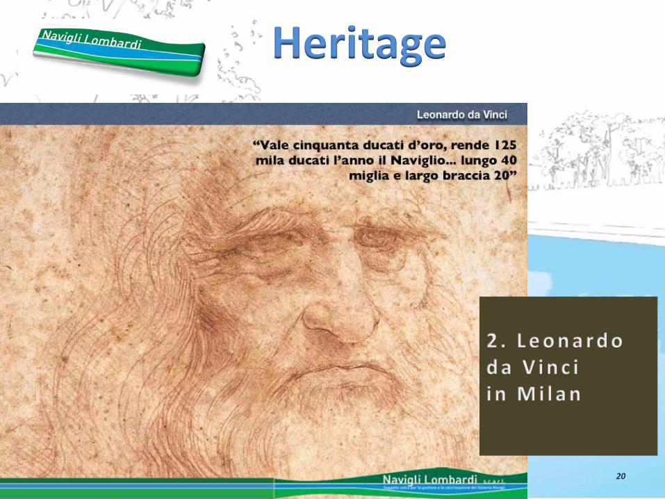
20
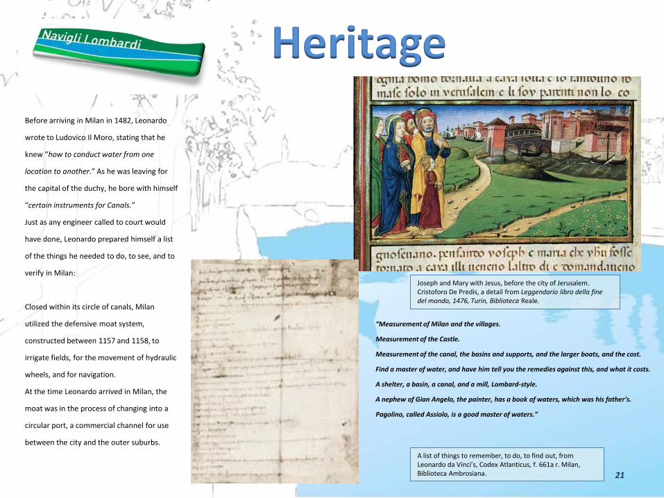
Before arriving in Milan in 1482, Leonardo
wrote to Ludovico Il Moro, stating that he
knew “how to conduct water from one
location to another.” As he was leaving for
the capital of the duchy, he bore with himself
“certain instruments for Canals.”
Just as any engineer called to court would
have done, Leonardo prepared himself a list
of the things he needed to do, to see, and to
verify in Milan:
Closed within its circle of canals, Milan
utilized the defensive moat system,
constructed between 1157 and 1158, to
irrigate fields, for the movement of hydraulic
wheels, and for navigation.
At the time Leonardo arrived in Milan, the
moat was in the process of changing into a
circular port, a commercial channel for use
between the city and the outer suburbs.
A list of things to remember, to do, to find out, from Leonardo da Vinci’s, Codex Atlanticus, f. 661a r. Milan, Biblioteca Ambrosiana.
Joseph and Mary with Jesus, before the city of Jerusalem. Cristoforo De Predis, a detail from Leggendario libro della fine del mondo, 1476, Turin, Biblioteca Reale.
Heritage
“Measurement of Milan and the villages.
Measurement of the Castle.
Measurement of the canal, the basins and supports, and the larger boats, and the cost.
Find a master of water, and have him tell you the remedies against this, and what it costs.
A shelter, a basin, a canal, and a mill, Lombard-style.
A nephew of Gian Angelo, the painter, has a book of waters, which was his father’s.
Pagolino, called Assiolo, is a good master of waters.”
21
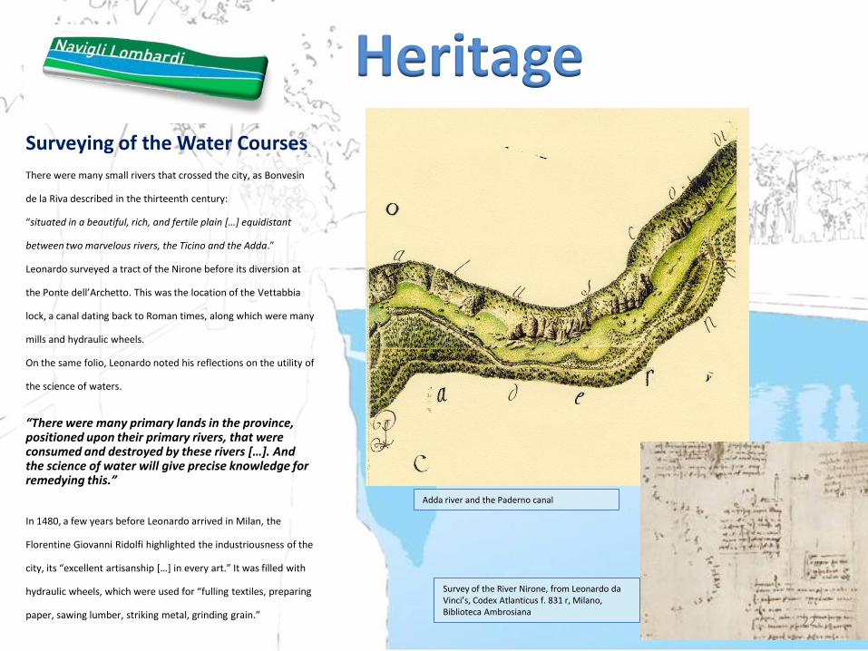
Surveying of the Water Courses
There were many small rivers that crossed the city, as Bonvesin
de la Riva described in the thirteenth century:
“situated in a beautiful, rich, and fertile plain […] equidistant
between two marvelous rivers, the Ticino and the Adda.”
Leonardo surveyed a tract of the Nirone before its diversion at
the Ponte dell’Archetto. This was the location of the Vettabbia
lock, a canal dating back to Roman times, along which were many
mills and hydraulic wheels.
On the same folio, Leonardo noted his reflections on the utility of
the science of waters.
“There were many primary lands in the province, positioned upon their primary rivers, that were consumed and destroyed by these rivers […]. And the science of water will give precise knowledge for remedying this.”
In 1480, a few years before Leonardo arrived in Milan, the
Florentine Giovanni Ridolfi highlighted the industriousness of the
city, its “excellent artisanship […] in every art.” It was filled with
hydraulic wheels, which were used for “fulling textiles, preparing
paper, sawing lumber, striking metal, grinding grain.”
Survey of the River Nirone, from Leonardo da Vinci’s, Codex Atlanticus f. 831 r, Milano, Biblioteca Ambrosiana
Heritage
Adda river and the Paderno canal
22
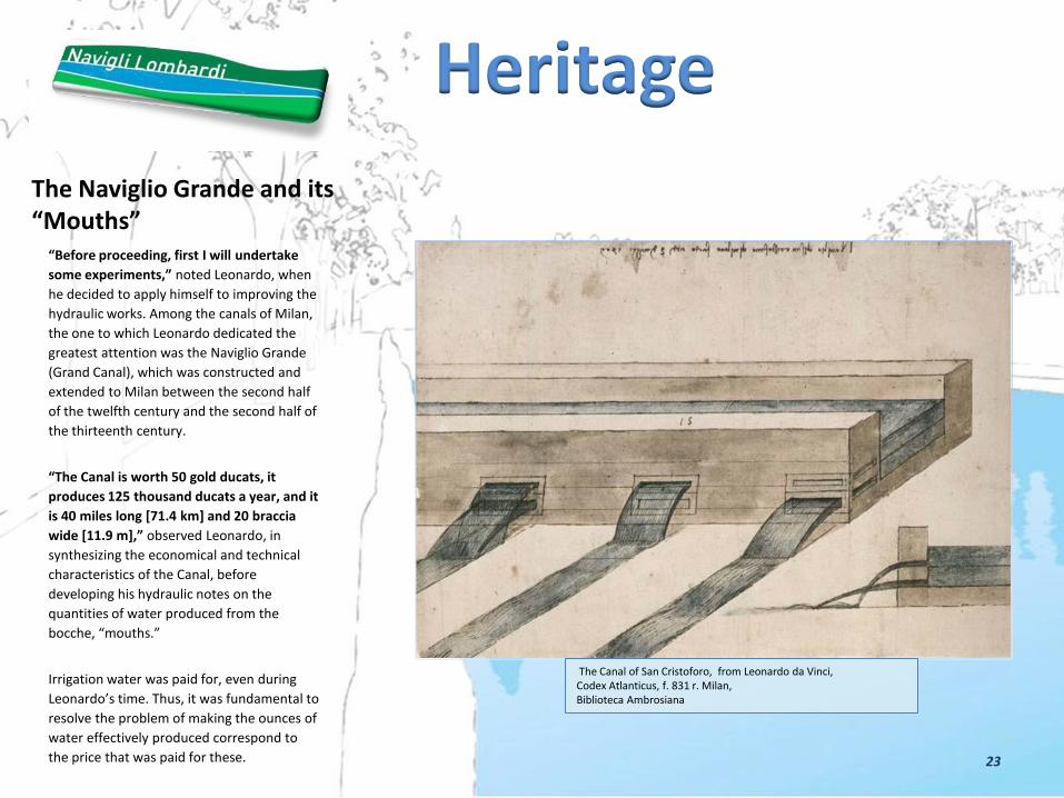
The Naviglio Grande and its “Mouths” “Before proceeding, first I will undertake
some experiments,” noted Leonardo, when
he decided to apply himself to improving the
hydraulic works. Among the canals of Milan,
the one to which Leonardo dedicated the
greatest attention was the Naviglio Grande
(Grand Canal), which was constructed and
extended to Milan between the second half
of the twelfth century and the second half of
the thirteenth century.
“The Canal is worth 50 gold ducats, it
produces 125 thousand ducats a year, and it
is 40 miles long [71.4 km] and 20 braccia
wide [11.9 m],” observed Leonardo, in
synthesizing the economical and technical
characteristics of the Canal, before
developing his hydraulic notes on the
quantities of water produced from the
bocche, “mouths.”
Irrigation water was paid for, even during
Leonardo’s time. Thus, it was fundamental to
resolve the problem of making the ounces of
water effectively produced correspond to
the price that was paid for these.
The Canal of San Cristoforo, from Leonardo da Vinci, Codex Atlanticus, f. 831 r. Milan, Biblioteca Ambrosiana
Heritage
23

The Role of the Martesana
In 1457, the duke Francesco Sforza ordered
the construction of a canal on the east side
of the duchy, in symmetry with the Naviglio
Grande, to bring the waters of the Adda to
Milan.
Excavated from the base rock along the right
bank of the river, the Martesana Canal was
constructed by Bertola da Novate in just 7
years (1457- 1463).
“[…] when the Martesana Canal was made,
this diminished the waters of the Adda,
which are now distributed throughout many
villages, in service of the fields.”
From Castello di Trezzo on the Adda, the
river waters make their way to Cassano
d’Adda, turn toward Milan, and flow into the
Seveso, increasing the volume of the waters
in the moats around Milan.
The territory between the Rivers Adda and Brembo, 13th century,Venice, Archivio di Stato
San Cristoforo’s Canal, from Leonardo da Vinci, Codex Atlanticus, f. 831 r. Milan, Biblioteca Ambrosiana
Heritage
24

The Martesana Canal and its Spillways
Leonardo displayed a great interest for
works of practical hydraulics, especially for
the constructions of the Canals and the
resistance of their banks.
His interest is obvious in his design for the
Martesana Canal, in which he depicts one of
the spillways used for the canal to return
waters to the river during low flow.
“No canal that flows out of rivers will last if
the water of the river from which it arises is
not completely enclosed, as in the
Martesana Canal and the one that flows out
of the Ticino [the Naviglio Grande].”
Codex Atlanticus, f. 184 v.
The Adda and the Martesana at the Rocca di Concesa, by Leonardo da Vinci, RL 12399, Windsor, Royal Library
River Adda from Brivio to Trezzo, 1753. Milan, Archivio di Stato.
Heritage
25

The Paderno Canal
The second hypothesis for the extension of
the navigational route from Lago di Como
to Trezzo sull’Adda is indicated in a splendid
view of the middle valley of the river, from
the lake to the beginning of the Martesana,
where Leonardo drew a short canal in
correspondence with the Gola di Paderno.
“Have a concavity be made in the Tre Corni,
where the wall stands,
closing the water.”
Codex Atlanticus, f. 388 v.
Leonardo designed another canal before the
river bends at Trezzo sull’Adda, which
diverted toward the Milanese plain, for
irrigating a broad territory north of the
Martesana.
Planimetry of a section of the River Adda, from Leonardo da Vinci’s , Codex Atlanticus, f. 911 r. Milan, Biblioteca Ambrosiana.
Heritage
26

The Ferry between Vaprio and Canonica While a guest at the villa of his favorite
pupil, Francesco Melzi, located at the
heights of Vaprio d’Adda, Leonardo
designed the ferry of “La Canonica,” with a
cord extended between the two banks, to
be drawn across the river with a load of
livestock.
The drawing can be dated between 1509
and 1511; it also represents the junction of
the Brembo with the Adda, the dike, and
the outlet for the artificial canal of Vailate
(c. 1474) for the irrigation of the Pontirolo
district.
Two centuries later, the painters Gaspar
van Wittel and Bernardo Bellotto drew and
painted the port between Canonica and
Vaprio d’Adda, with the analytical and
objective style typical of painters of
vedutas. During the eighteenth century,
this port became one of the stopping points
on the Grand Tour.
The ferry between Vaprio and Canonica, by Leonardo da Vinci, RL 12400, Windsor,Royal Library
Bernardo Bellotto, Vaprio and Canonica north-westwards, c. 1744. Milan, private collection.
Heritage
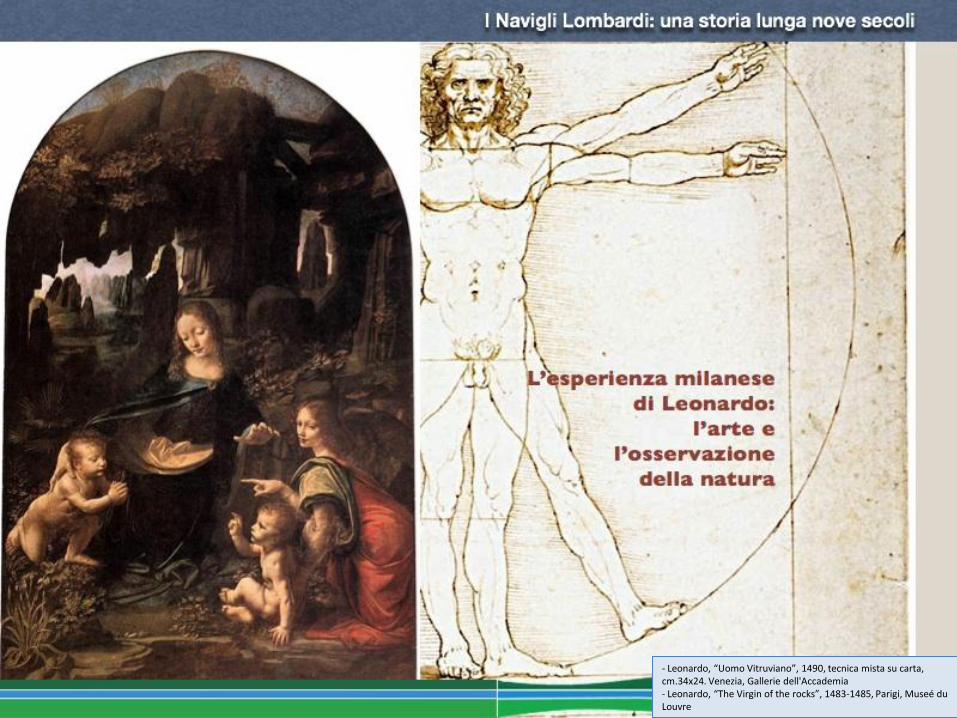
- Leonardo, “Uomo Vitruviano”, 1490, tecnica mista su carta, cm.34x24. Venezia, Gallerie dell'Accademia - Leonardo, “The Virgin of the rocks”, 1483-1485, Parigi, Museé du Louvre


Milan in Representation During Leonardo’s first stay in Milan (1482-1499),
Leonardo drew a suggestive map of the city: for the
very first time, the tract of the Martesana Canal
between Porta Nuova and Piazza San Marco appeared
on the map of Milan
Leonardo made notations regarding the city gates of
Milan, with indications of their distances from the
Strada Nova and the Porta Cumana. The notations also
included the Martesana Canal. The lower part of the
folio presents a suggestive aerial view of the city,
showing the main buildings. Among these, we see the
Castello Sforzesco and the cathedral, under
construction
Map of Milan, from Leonardo da Vinci’s, Codex Atlanticus, f. 199 v. Milan, Biblioteca Ambrosiana. 30
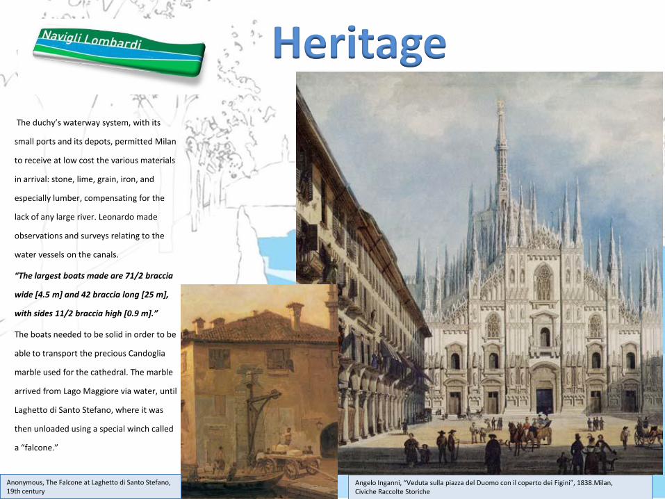
The duchy’s waterway system, with its
small ports and its depots, permitted Milan
to receive at low cost the various materials
in arrival: stone, lime, grain, iron, and
especially lumber, compensating for the
lack of any large river. Leonardo made
observations and surveys relating to the
water vessels on the canals.
“The largest boats made are 71/2 braccia
wide [4.5 m] and 42 braccia long [25 m],
with sides 11/2 braccia high [0.9 m].”
The boats needed to be solid in order to be
able to transport the precious Candoglia
marble used for the cathedral. The marble
arrived from Lago Maggiore via water, until
Laghetto di Santo Stefano, where it was
then unloaded using a special winch called
a “falcone.”
Angelo Inganni, “Veduta sulla piazza del Duomo con il coperto dei Figini”, 1838.Milan, Civiche Raccolte Storiche
Anonymous, The Falcone at Laghetto di Santo Stefano, 19th century
Heritage
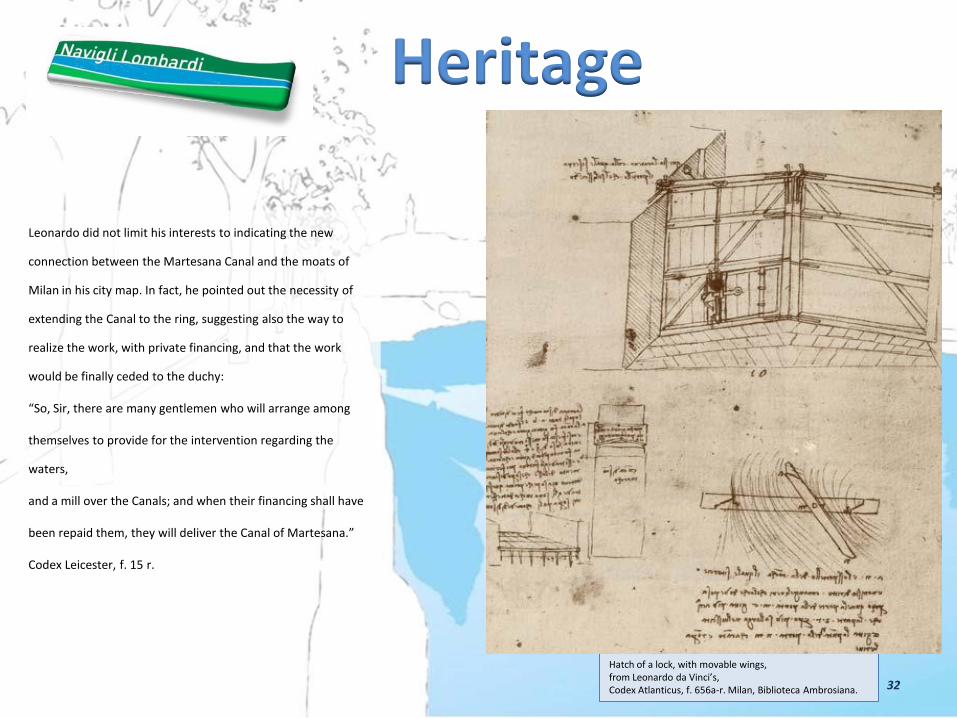
Leonardo did not limit his interests to indicating the new
connection between the Martesana Canal and the moats of
Milan in his city map. In fact, he pointed out the necessity of
extending the Canal to the ring, suggesting also the way to
realize the work, with private financing, and that the work
would be finally ceded to the duchy:
“So, Sir, there are many gentlemen who will arrange among
themselves to provide for the intervention regarding the
waters,
and a mill over the Canals; and when their financing shall have
been repaid them, they will deliver the Canal of Martesana.”
Codex Leicester, f. 15 r.
Hatch of a lock, with movable wings, from Leonardo da Vinci’s, Codex Atlanticus, f. 656a-r. Milan, Biblioteca Ambrosiana.
Heritage
32
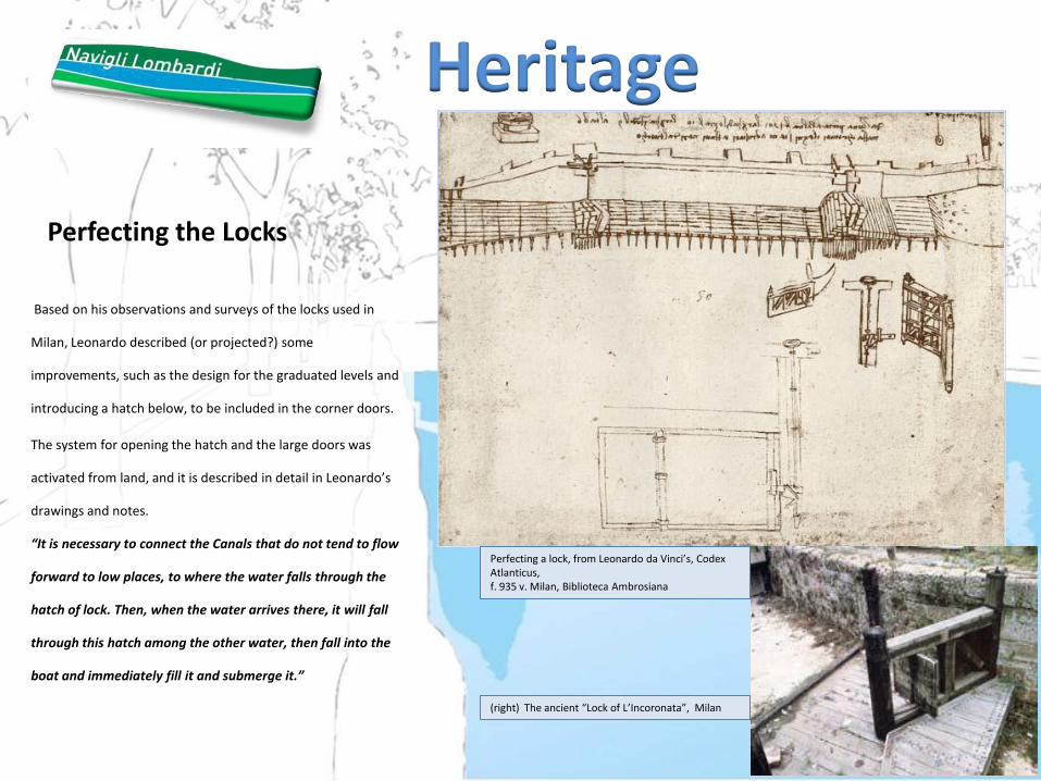
Perfecting the Locks
Based on his observations and surveys of the locks used in
Milan, Leonardo described (or projected?) some
improvements, such as the design for the graduated levels and
introducing a hatch below, to be included in the corner doors.
The system for opening the hatch and the large doors was
activated from land, and it is described in detail in Leonardo’s
drawings and notes.
“It is necessary to connect the Canals that do not tend to flow
forward to low places, to where the water falls through the
hatch of lock. Then, when the water arrives there, it will fall
through this hatch among the other water, then fall into the
boat and immediately fill it and submerge it.”
(right) The ancient “Lock of L’Incoronata”, Milan
Perfecting a lock, from Leonardo da Vinci’s, Codex Atlanticus, f. 935 v. Milan, Biblioteca Ambrosiana
Heritage
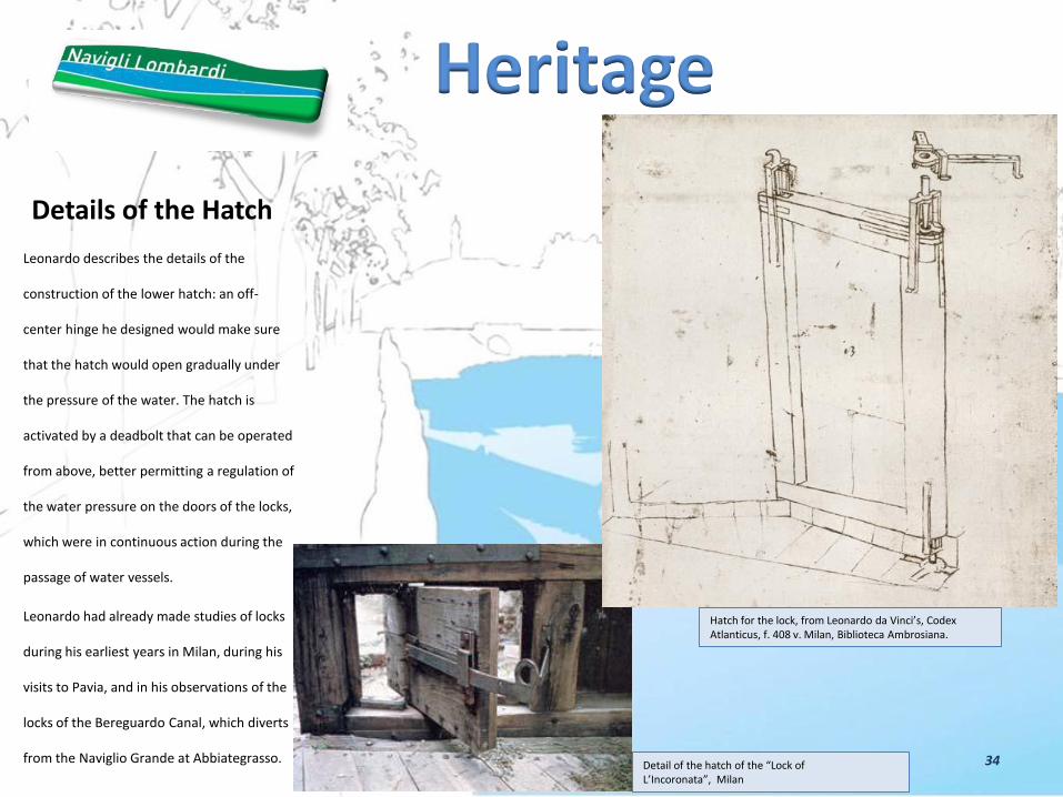
Details of the Hatch
Leonardo describes the details of the
construction of the lower hatch: an off-
center hinge he designed would make sure
that the hatch would open gradually under
the pressure of the water. The hatch is
activated by a deadbolt that can be operated
from above, better permitting a regulation of
the water pressure on the doors of the locks,
which were in continuous action during the
passage of water vessels.
Leonardo had already made studies of locks
during his earliest years in Milan, during his
visits to Pavia, and in his observations of the
locks of the Bereguardo Canal, which diverts
from the Naviglio Grande at Abbiategrasso.
Detail of the hatch of the “Lock of L’Incoronata”, Milan
Hatch for the lock, from Leonardo da Vinci’s, Codex Atlanticus, f. 408 v. Milan, Biblioteca Ambrosiana.
Heritage
34

Canals and Mills
Besides his studies and observations in regard to land reclaiming,
hydraulics, and irrigation, Leonardo’s notes confirm his interest
for the operation of mills and the canals that propelled them.
These drawings probably date from 1493-1494, when Leonardo
was at Vigevano.
His notes include calculations about the yields of the mills,
expense estimates for various parts, and sketches of gears
intended to improve the mechanical operation.
Leonardo recorded some of the many applications, besides
agriculture, for which mills could be used, such as in the
production of textiles or in the manufacturing of gunpowder.
View from the Sforzesca, one of the model farms that Ludovico Il Moro wanted built in the territory around Vigevano.
Multiple cylinder mill, from Leonardo da Vinci’s, Codex Atlanticus, f. 830c v. Milan, Biblioteca Ambrosiana.
Heritage
35
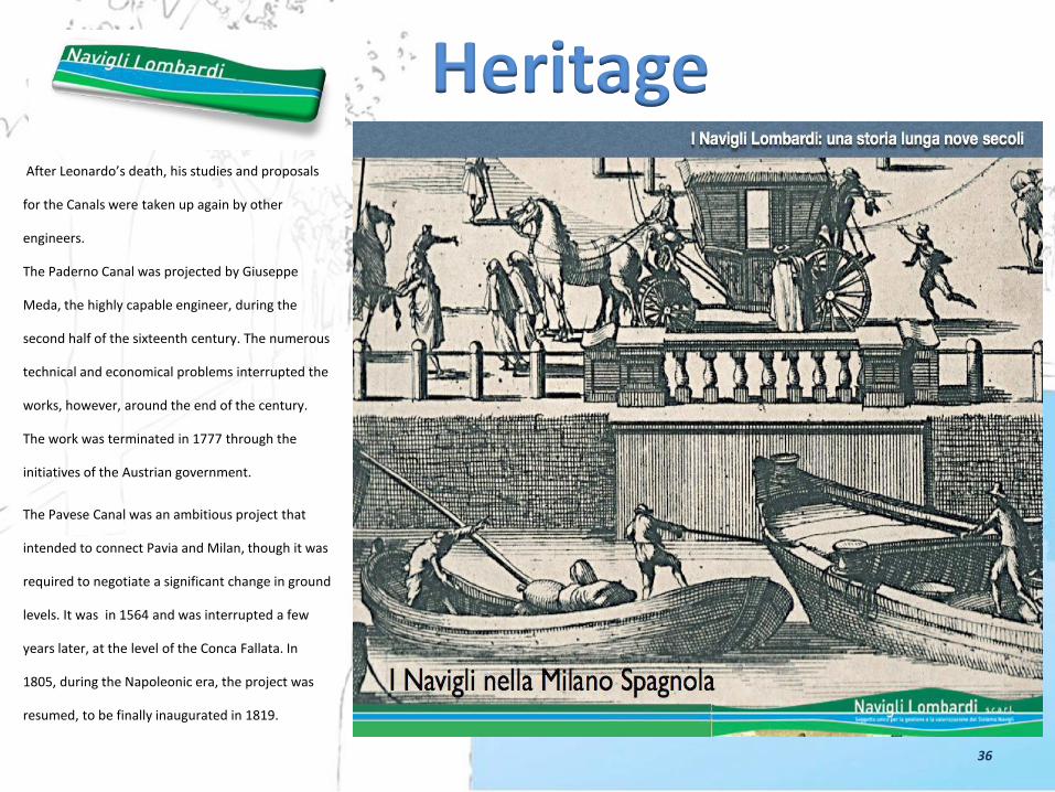
After Leonardo’s death, his studies and proposals
for the Canals were taken up again by other
engineers.
The Paderno Canal was projected by Giuseppe
Meda, the highly capable engineer, during the
second half of the sixteenth century. The numerous
technical and economical problems interrupted the
works, however, around the end of the century.
The work was terminated in 1777 through the
initiatives of the Austrian government.
The Pavese Canal was an ambitious project that
intended to connect Pavia and Milan, though it was
required to negotiate a significant change in ground
levels. It was in 1564 and was interrupted a few
years later, at the level of the Conca Fallata. In
1805, during the Napoleonic era, the project was
resumed, to be finally inaugurated in 1819.
Heritage
36

The Covering of the Canals
During the nineteenth century, with the arrival of railroads and the
subsequent invention of internal combustion engines,
transportation on rails and on roads was facilitated, which resulted
in an increasing diminution of the importance of the canals as a
system of transportation and communication.
The inner canal network in Milan began to raise worries about
hygiene because of its putrid waters. After it ceased being a
privileged transportation route, it even became a sort of obstacle
to the expansion of the city.
In 1857, the Laghetto di Santo Stefano was filled in by orders of the
emperor Franz Joseph. The filling in of the inner canal excavation
was begun at the end of the century and completed between 1929
and 1930.
Finally, between 1951 and 1968, the tract of the Martesana Canal
within the city was covered over, along via Melchiorre Gioia all the
way to the Cassina de’ Pomm.
The covering over of the inner canal excavation, in 1929-1930 in Milan, via Senato.
Heritage
37

Heritage
38
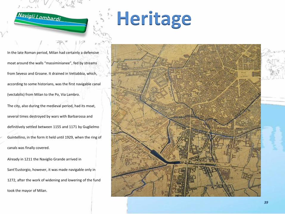
In the late Roman period, Milan had certainly a defensive
moat around the walls “massiminianee”, fed by streams
from Seveso and Groane. It drained in Vettabbia, which,
according to some historians, was the first navigable canal
(vectabilis) from Milan to the Po, Via Lambro.
The city, also during the medieval period, had its moat,
several times destroyed by wars with Barbarossa and
definitively settled between 1155 and 1171 by Guglielmo
Guintellino, in the form it held until 1929, when the ring of
canals was finally covered.
Already in 1211 the Naviglio Grande arrived in
Sant'Eustorgio, however, it was made navigable only in
1272, after the work of widening and lowering of the fund
took the mayor of Milan.
Heritage
39
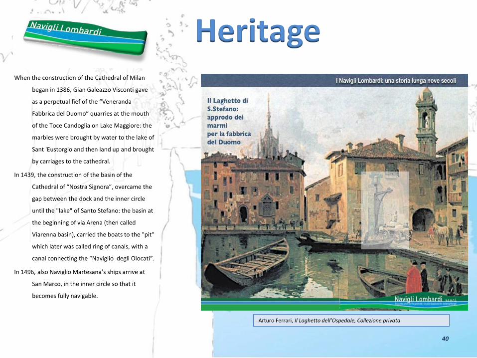
When the construction of the Cathedral of Milan
began in 1386, Gian Galeazzo Visconti gave
as a perpetual fief of the “Veneranda
Fabbrica del Duomo” quarries at the mouth
of the Toce Candoglia on Lake Maggiore: the
marbles were brought by water to the lake of
Sant 'Eustorgio and then land up and brought
by carriages to the cathedral.
In 1439, the construction of the basin of the
Cathedral of “Nostra Signora”, overcame the
gap between the dock and the inner circle
until the "lake" of Santo Stefano: the basin at
the beginning of via Arena (then called
Viarenna basin), carried the boats to the "pit"
which later was called ring of canals, with a
canal connecting the “Naviglio degli Olocati”.
In 1496, also Naviglio Martesana’s ships arrive at
San Marco, in the inner circle so that it
becomes fully navigable.
Arturo Ferrari, Il Laghetto dell’Ospedale, Collezione privata
Heritage
40

Along the ring of canals a lot of buildings
and palaces
embellished and endowed with small
docks, furthermore grew up numerous
"sciostre" - sites for loading and
unloading of goods.
In 1819 the dock was enlarged by the
the opening of the canal “Navigli o
Pavese , and again in 1919, after the
demolition of the spur the Spanish
walls.
Heritage
41

The ring of canals was covered in 1929
and finally buried around the sixties of last
century to stability problems of the road
above.
Signs of the presence of the waterway
within the city still remain: in appearing
ofsome gardens on the road, (Via Visconti
di Modrone and via Senato), in the shape
of the openings of the old "sciostre" (Via
Molino delle Armi), in the old medieval
Porta Ticinese, etc.
Heritage
42

The canals were the protagonists
reconstruction of Milan in the second
Postwar as access routes available for heavy
loads since roads, bridges and railways were
severely damaged by bombing.
And it‘s interesting to note that in 1959 the
dock of Milan “Darsena” was the third
tonnage port in Italy for goods exchanged.
Not surprisingly, despite the multiplicity of
owners and managers who have succeeded in
the past nine centuries until at least the late
'50s, the
ships have always not only produced the
resources necessary to sustain its cleaning,
maintenance and management, but for the
construction and expansion and many of its
network hydraulic works that "populate" the
appliances channels.
Heritage
43

The urban landscape
overlooking the ring
of canals is still
perfectly readable,
although some
interventions of the
postwar period, and
the entire path of the
circle, is one of the
places that
characterize the city.
“Conca di via Senato” in Milan - “Il Naviglio di Porta Venezia sotto la neve” di Angelo Inganni – (source) “I Navigli da Milano lungo i canali – Ed. Celip 2002 pagg. 58-59
Heritage
Conca dell’Incoronata in Milan
44
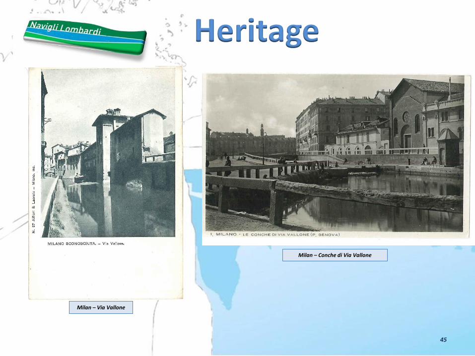
Milan – Via Vallone
Milan – Conche di Via Vallone
Heritage
45

Milan - Via San Damiano Milan - Via S. Marco
Heritage
46

Naviglio Grande in Milan Milan - Darsena
Heritage
47

48
Heritage