· 1836 Rif. Valasco 1764 A.T.L. (A i enda T uri s ti c a Lo ca le) de l Cun ees e ......
2
Controllato ai sensi della Legge 2.2.1960 n.68. Nulla-osta alla diffusione n. 399 in data 10.11.1995 © C.C.I.A.A. CUNEO / AMMINISTRAZIONE PROVINCIALE CUNEO Rif. Malinvern 1836 Rif. Valasco 1764 A.T.L. (Azienda Turistica Locale) del Cuneese Via Vittorio Amedeo II, 8A - 12100 Cuneo Tel. +39.0171.690217 - Fax +39.0171.602773 [email protected] www.cuneoholiday.com Cuneo e le sue valli sempre con te: scarica la GrandAmour App! Disponibile su: e 1 2 3 4 5 6 M o t o r b i k e I t i n e r a r i e s i n t h e V a ll e y s o f t h e P r o v in c e o f C u n e o Via Pascal, 7 - 12100 Cuneo Ph. +39.0171.690217 - [email protected] (Local Tourism Agency of the Province of Cuneo) GrandAmour App: The region of Cuneo and its valleys always at hand. Available for free Motorways Trunk roads Provincial roads Municipal roads Dirt roads Scenic roads Tunnels Railways State border Province border Park border GTA (Grande Traversata delle Alpi) trails Open shelters (staffed) Museums River canoeing Ski resorts Cross-country ski resorts Centres of historic and artistic interest Caves Rock climbing facilities Camping Castles, fortresses Churches, Sanctuaries, Abbeys Airports Golf Spas and thermal treatments facilities Regional wineries, wine shops, co-operative wineries and 1: 200.000 scale map Realised within the project Interreg-Alcotra NTC – Nuovo Territorio Condiviso ⬅ ⬅ ⬅ ⬅ ⬅ ⬅ ⬅ ⬅ ⬅ ⬅ ⬅ ⬅ ⬅ ⬅ ⬅ ⬅ ⬅ ⬅ ⬅ ⬅ ⬅ ⬅ ⬅ ⬅ ⬅ ⬅ ⬅ ⬅ ⬅ ⬅ ⬅ ⬅ ⬅ ⬅ ⬅ ⬅ ⬅ ⬅ ⬅ ⬅ ⬅ ⬅ ⬅ ⬅ ⬅ ⬅ ⬅
Transcript of · 1836 Rif. Valasco 1764 A.T.L. (A i enda T uri s ti c a Lo ca le) de l Cun ees e ......
Controllato ai sensi della Legge 2.2.1960 n.68. Nulla-osta alla diffusione n. 399 in data 10.11.1995© C.C.I.A.A. CUNEO / AMMINISTRAZIONE PROVINCIALE CUNEO
Rif. Malinvern 1836
Rif. Valasco
1764
A.T.L. (Azienda Turistica Locale) del CuneeseVia Vittorio Amedeo II, 8A - 12100 CuneoTel. +39.0171.690217 - Fax [email protected]
www.cuneoholiday.com
Cuneo e le sue valli sempre con te: scarica la GrandAmour App!
Disponibile su:
e
PROGRAMMA ALCOTRA 2007-13 FONDO EUROPEODI SVILUPPO REGIONALE
1
2
3
4
5
6
Motorbike Itineraries in the Valleys of the Province of Cuneo
Via Pascal, 7 - 12100 CuneoPh. +39.0171.690217 - [email protected]
(Local Tourism Agency of the Province of Cuneo)
GrandAmour App: The region of Cuneoand its valleys always at hand.Available for free
Motorways
Trunk roads
Provincial roads
Municipal roads
Dirt roads
Scenic roads
Tunnels
Railways
State border
Province border
Park border
GTA (Grande Traversata delle Alpi) trails
Open shelters (staffed)
Museums
River canoeing
Ski resorts
Cross-country ski resorts
Centres of historicand artistic interest
Caves
Rock climbing facilities
Camping
Castles, fortresses
Churches, Sanctuaries, Abbeys
Airports
Golf
Spas and thermal treatments facilities
Regional wineries, wine shops,co-operative wineries
A.T.L. (Azienda Turistica Locale) del CuneeseVia Vittorio Amedeo II, 8A - 12100 CuneoTel. +39.0171.690217 - Fax [email protected]
www.cuneoholiday.com
Cuneo e le sue valli sempre con te: scarica la GrandAmour App!
Disponibile su:
e
PROGRAMMA ALCOTRA 2007-13 FONDO EUROPEODI SVILUPPO REGIONALE
and
1: 200.000 scale map
Realised within the projectInterreg-Alcotra NTC – Nuovo Territorio Condiviso
A.T.L. (Azienda Turistica Locale) del CuneeseVia Vittorio Amedeo II, 8A - 12100 CuneoTel. +39.0171.690217 - Fax [email protected]
www.cuneoholiday.com
Cuneo e le sue valli sempre con te: scarica la GrandAmour App!
Disponibile su:
e
PROGRAMMA ALCOTRA 2007-13 FONDO EUROPEODI SVILUPPO REGIONALE
⬅
⬅⬅
⬅
⬅
⬅
⬅
⬅
⬅
⬅
⬅
⬅
⬅
⬅ ⬅
⬅⬅
⬅ ⬅⬅
⬅ ⬅
⬅
⬅⬅
⬅
⬅
⬅
⬅
⬅⬅⬅
⬅
⬅ ⬅
⬅⬅
⬅
⬅
⬅
⬅
⬅ ⬅
⬅
⬅
⬅
⬅
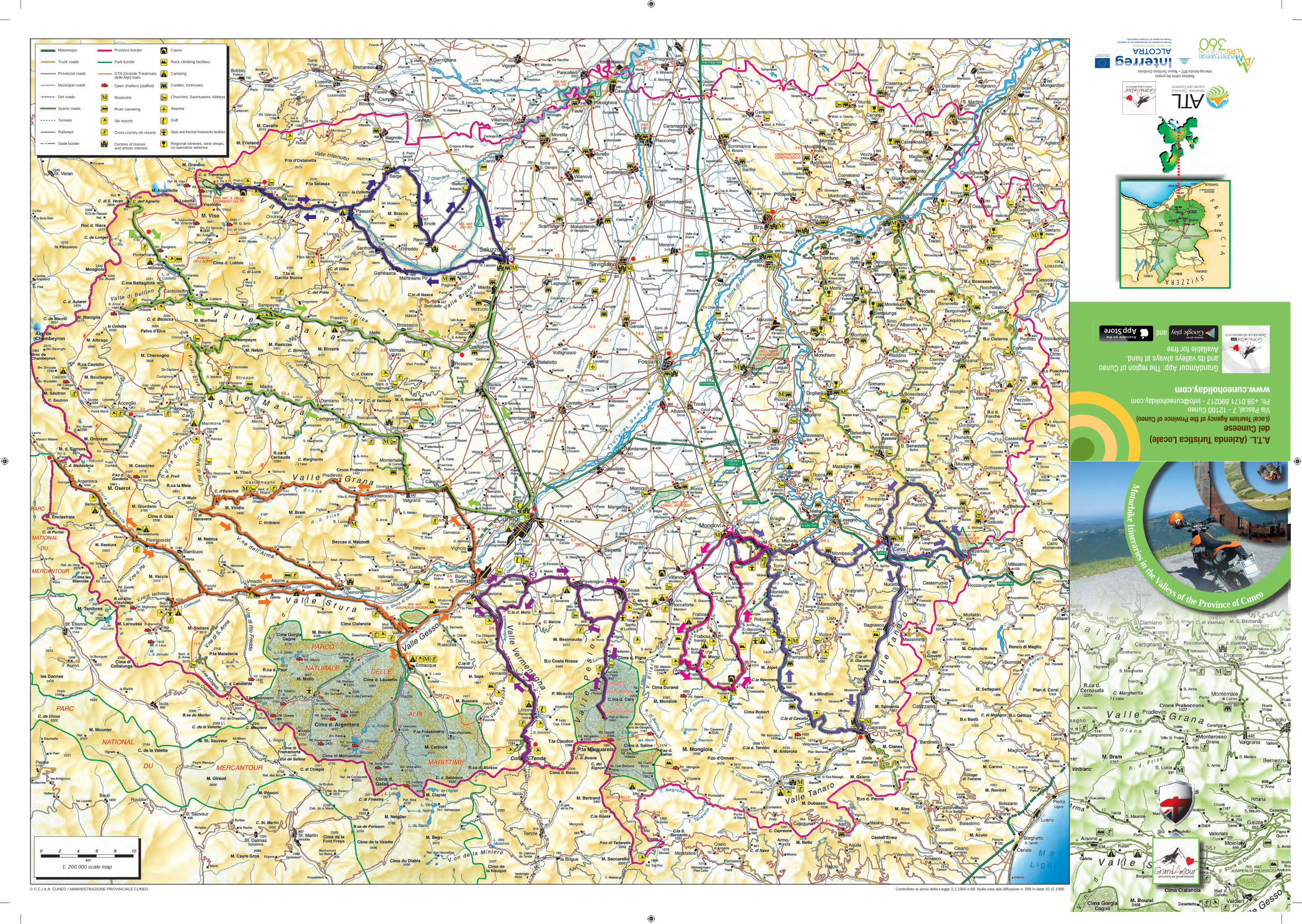
ITINERARY 1MONDOVÌ-MONDOVÌ: THE TANARO VALLEYAND THE LANGA OF CEVAItinerary features:Distance: 138 kmDuration: one daySuggested season: from May to OctoberType of roads: Asphalt - country roads - scenic roads
ITINERARY 2MONDOVÌ-MONDOVÌ: DISCOVERING THE MONREGALESI VALLEYSItinerary features:Distance: 72 kmDuration: half daySuggested season: from June to OctoberType of roads: Asphalt - country roads - scenic roads
This itinerary starts from the ancient district of Piazza Maggiore in Mondovì, where operates the funicular which already in the nineteenth century was connecting the lower part of the town (Breo) with the higher one (Piazza). Surrounded by porticoes and ancient buildings, the district of Piazza offers many visit opportunities: the Chiesa della Missione (Mission Church), containing a masterpiece of the baroque art of Andrea Pozzo, the Museo della Ceramica (Pottery Museum), typical production of the monregalese area, and the Palazzo del Vescovado (Bishop’s Palace), ancient seat of the university. In the Belvedere garden, where the impressive medieval tower of the Bressani stands out, you can enjoy a breathtaking view over the plain and the monregalese Langa.Exit Mondovì in the direction of Villanova along the SP5 (provincial road no. 5), go through the village of Villanova (where you can visit the Grotte dei Dossi – Dossi caves) and, at the roundabout, take the second exit into the SP37 (provincial road no. 37) in the direction of Frabosa Sottana in the Maudagna valley: the road twists and turns fast with wide curves up to Frabosa, continuing then in the direction of Artesina and Prato Nevoso, where the road becomes a very enjoyable mixed route: here you can also stop and enjoy a visit to the Grotte del Caudano (Caudano Caves).
At the junction with Artesina - Prato Nevoso, turn left in the direction of Prato Nevoso. After a series of curves and hairpin turns, you will reach the start of the ski lifts of Prato Nevoso (1620 m), part of the Mondolè Ski ski area, which offers over 120 km of ski runs for the snow lovers. From here, welcomed by the imposing and enchanting mount Mondolè, you follow the road to the end, in the district of Malanotte. This is probably the most fascinating panoramic point of the province of Cuneo, where you can enjoy the view of the whole alpine area, including Monte Rosa...you can’t miss a stop here! Then, you go downhill again for a couple of kilometres and turn in the direction of the Corsaglia Valley, take the Colle del Prel road leading to the Corsaglia Valley and arriving at the discrict of Fontane, after going along a narrow road
ITINERARY 5CUNEO-CUNEO: THE GRANA, MAIRA AND VARAITA VALLEYSItinerary features: Distance: 201 kmDuration: one daySuggested season: from June to OctoberType of roads: Asphalt -country roads - scenic roads
The itinerary starts from Cuneo (534 metres above sea level), capital of the “Provincia Granda” (literally “Great Province”, since it is the largest province in Piedmont and one of the largest in Italy), where, walking under the medieval porticoes of the historic city centre, you find some of the most significant monuments of the town: the Duomo, with its neoclassical facade but baroque interiors; the Church of Sant’Ambrogio; the complex of the church and the former convent of San Francesco, seat of the Museo Civico (civic museum), which still retains the original medieval architecture, recently restored. From Piazza Galimberti you take Corso Soleri to exit the town, going along the bridge on river Stura up to the roundabout: here you go in the direction of Caraglio into the SP 422 (provincial road no. 422). Continuing in the direction of the Maira Valley, just outside the centre of Caraglio, you find on the left the Filatoio (Spinning Plant), one of the oldest examples of industrial archaeology in Europe. The building, which hosts contemporary art exhibitions and a small Silk Museum, resembles
a fortified residence. On the way back, from the centre of Caraglio you follow the direction of the Grana Valley along the SP23 (provincial road no. 23) as far as Valgrana, where you turn proceeding along a hilltop route leading to the village of Montemale, and then go downhill to Dronero. It is worth to stop and enjoy a gastronomic experience in Caraglio or in Valgrana, to taste the typical Gnocchi with Castelmagno, or in Montemale, at the foot of the castle atop the mountain peak, to try the tagliatelle with the black truffles which grow in the nearby woods.In Dronero several buildings, such as the octagonal Foro Frumentario (grain market building) of the beginning of the fifteenth century, bear witness of flourishing Middle Ages. Not to be missed the crenellated bridge on river Maira, the Mulino della Riviera (Riviera Mill) and the Mallè Museum, housed in the elegant residence of Luigi Mallè.
ITINERARY 4CARAGLIO-CARAGLIO: THE GRANA, GESSO AND STURA VALLEYSItinerary features: Distance: 191 kmDuration: one daySuggested season: from June to OctoberType of roads: Asphalt - country roads - scenic roads
From Caraglio take the provincial road that climbs up the Grana Valley through the villages of Valgrana, Monterosso Grana (here you can make a detour on the right to Sancto Lucio and visit the Ethnographic Museum dedicated to the Provençal traditions), Pradleves up to Castelmagno (1661 m), where in the summer season the ancient Sanctuary of San Magno is open to the public. In the valley you cannot miss a gastronomic stop to try the typical gnocchi served with Castelmagno, a PDO cheese “di
alpeggio” (from Alpine pasture) produced in the upper valley. For the first 20 km the road continues in long straights and then narrows after Castelmagno, where the bends leading to the Sanctuary begin; from here the road narrows further but it is nestled in an extremely charming natural setting for the beauty of the surrounding landscape. From Castelmagno you
continue uphill to Colle d’Esischie, then turn left to Colle di Valcavera, which leads to the Stura Valley going through the Colle dei Morti or Fauniera; here, at 2481 metres of height, it is worth stopping to admire the statue dedicated to Marco Pantani, commemorating the exciting rides of an athlete much
beloved by the public. You go then downhill through the Vallone dell’Arma leading to Demonte and then up again through the Stura Valley along the SS21 (trunk road no. 21) leading to the French border located on the Colle della Maddalena/
Col de Larche, going through the villages of Aisone, Vinadio, Sambuco, Pietraporzio, Bersezio and Argentera. From Demonte you continue through long straight stretches and wide bends up to the Barricate di Petraporzio; from here, the road becomes panoramic and breathtaking hairpin bends begin, leading to the plain of the Colle della Maddalena/Col de Larche (1996 m), where you should
ITINERARY 6SALUZZO-SALUZZO: THROUGH THE PO VALLEYItinerary features: Distance: 91 kmDuration: half daySuggested season: from May to OctoberType of roads: Asphalt - country roads - scenic roads
The town of Saluzzo was the capital of an ancient and powerful Marquisate and has managed to preserve its magnificent medieval historic centre, overlooked by the outline of Monviso. You can go up on your bike to the Castiglia, dominating the town, and park here to continue on foot along the ancient narrow streets. On the way there, you will find the Torre Civica (Civic Tower), the Church of San Giovanni, the Civic Museum Casa Cavassa and finally the Cathedral.Exit Saluzzo in the direction of the Po Valley and, at the junction, follow the direction of Martiniana Po, Gambasca, Sanfront, through Paesana and Crissolo and, at Pian della Regina (Queen’s plateau), continue as far as Pian del Re (King’s plateau, 2020 m). We are now in presence of the “Re di Pietra” (King of Stone), the Monviso, with its
3841 metres above sea level. The Pian del Re is a magnificent lush plain source of the river Po and the Pian della Regina, a little further downstream, is equally spectacular. We are, as a matter of fact, within the Parco del Po Cuneese (Po Park of Cuneo), which boasts a very extensive range of natural habitats thanks to the presence of water. In Crissolo it is worth a visit of the Sanctuary of San Chiaffredo, patron saint of the ancient Marquisate of Saluzzo, while in Sanfront, during the summer, Balma Boves is open to the public, a typical settlement carved out of the side of a rocky gorge, which represents a perfectly preserved and functional rural microcosm.Go down in the direction of Paesana and, after the village of Calcinere, turn left at the junction into Via
ITINERARY 3BOVES-BOVES: THE VERMENAGNA AND PESIO VALLEYSItinerary features:Distance: 121 kmDuration: half daySuggested season: from May to OctoberType of roads: Asphalt - country roads - scenic roads
In Boves, take Corso Bisalta in the direction of Madonna dei Boschi and turn left into Via Cerati; from here, in the midst of chestnut woods, the road climbs very steeply and takes you to Colletto del Moro after 4,8 km from the start and then descends to the SS20 (trunk road no. 20) of the Vermenagna Valley. From here, go downhill to the village of Robilante where, after a long straight stretch, you follow an enjoyable road with fast curves. Continuing along the trunk road, you go uphill through the Vermenagna Valley reaching Vernante, where you should stop to see the murals painted on the houses of the village and dedicated to Pinocchio: they were created basing on the original sketches by Attilio Mussino, the first illustrator of Collodi’s book. After some wide curves you reach Limone Piemonte, the most important summer and winter tourist destination of the Maritime Alps: born as a ski resort at the beginning of the twentieth century, it offers with the Riserva Bianca (White Reserve) over 80 km of Alpine ski runs with cutting-edge facilities. After a few wide and exciting hairpin bends, you reach the French border in the proximity of the Tenda road tunnel (1871 m). Here, you turn right in the direction of Panice Soprana, passed which you go uphill through a narrow road with equally narrow hairpin bends leading to the height of 1890 m, after 35,5 km from the start. Here the biker is welcomed by a stunning view
over the green alpine pastures, and the fun begins for those equipped with clawed wheels, discovering the blockhouses of the nineteenth century or the
Via del Sale (Salt Road).On the way back, you go again along the SS20 (trunk road no. 20) which crosses the entire Varmenagna Valley; at the roundabout near Roccavione take the first exit into the Via Provinciale of Boves; after going through Fontanelle, continue along the SP21 (provincial road no. 21) to Boves and then in the direction of Peveragno and Chiusa Pesio, where you take the SP42 (provincial road no. 42) of the Pesio Valley to ascend to the Certosa di Pesio (Pesio Charterhouse), going through the districts of Vigna and San Bartolomeo through a lively valley road. Chiusa Pesio welcomes its
road no. 430), where the medieval tower stands out, and reach Montezemolo, capital of honey located at the top of the hill, which is the meeting point between Piedmont and Liguria: you can’t miss a stop here, since you get there after 4 km of fast and amusing mixed route which continues on the SP661 (provincial road no. 661) up to Pedaggera and then turns left continuing in the direction of Garessio. After visiting the medieval village and the Sanctuary of Valsorda, continue in the direction of Pamparato along the SP178 (provincial road no. 178), going uphill to Colla di Casotto (1381 m): from here you go down to Pamparato, passing Valcasotto. In the woods of Valcasotto you find the Savoy Royal Castle, the favourite Savoy summer residence of Carlo Alberto and Vittorio Emanuele II.In the lovely mountain village
of Pamparato, you should make a stop to purchase the famous artisan “paste di meliga” (cornflour biscuits) and taste buckwheat polenta. From Pamparato, passing Roburent and Montaldo Mondovì, continue in the direction of Vicoforte along the SP35 (provincial road no. 35) as far as the junction that, turning on the left, takes you to the district of Moline and goes downhill to the SS28 (trunk road no. 28) near the Sanctuary of Vicoforte. To go back to Mondovì, continue along SS28 (trunk road no. 28) which takes you into the centre of Mondovì in the district of Breo. Here you can visit the church of Saint Pietro and Paolo, with its baroque facade, and the “Moro” (automaton that ticks away the hours) and then take the new funicular that leads to Piazza, the highest part of the town which features medieval buildings.
through fascinating woods and the impressing rocks called “i Denti della Vecchia” (old lady’s teeth). From here, the route continues to Bossea, where you can take a break and discover the Caves: at an altitude of 836 m, they are among the most important and beautiful caves in Italy, characterized by their grandiose dimensions. From Bossea, you keep descending along the SP232 (provincial road no.232) going through Corsaglia, after which a very amusing mixed route begins, which takes you to the village of Monastero Vasco; where, at the second
roundabout, you take the second exit leading to Vicoforte. Reach the Sanctuary Basilica Regina Montis Regalis for the visit: it is an impressive religious building dedicated to the Virgin and built in 1596 by Carlo Emanuele I Duke of Savoy. It boasts the world’s largest elliptical dome, whose vault is 6042 square metres wide and entirely frescoed with scenes of the life of the Virgin.From Piazza (Square) Carlo Emanuele I you go back to the provincial road and turn right taking the scenic road of the chapels that leads to Mondovì Piazza.
In the Maira Valley the Occitan language is spoken, which here preserves the resonance of the troubadours, and along the road that climbs up the valley you can find many Occitan inns, offering accommodation and board, with menus inspired by the Occitan tradition. From Dronero you take the SP 422 (provincial road no. 422), a scenic road ascending the whole Maira valley; after the junction to Stroppo, turn left and go along the
winding road leading to Elva, a very narrow but very fascinating mixed route. This small village retains the ancient church of Santa Maria Assunta, considered a jewel of gothic painting, with its apsis entirely frescoed by the flemish painter Hans Clemer, who worked in the end of the fifteenth century.From Elva you reach the Colle di Sampeyre, connecting the Maira
to the Varaita Valley, going along an astonishing high altitude scenic road (almost reaching 2200 m) and then downhill to Sampeyre. From here you continue ascending along the SP105 (provincial road no. 105) up to Casteldefino: a mixed route with wide bends and straights begins here, leading to the foot of the Colle dell’Agnello. A detour on the left in the valley of Bellino that, along with Casteldelfino and Pontechianale,
was part of the ancient Castellata, an alpine confederation linked to the French Dauphiné, allows you to visit the mountain village with the same name, with its ancient sundials frescoed on religious buildings and houses. Back to Casteldelfino, you take the SP 105 (provincial road no. 105) again and reach Pontechianale and Chianale, recognised as one of Italy’s most beautiful villages for its Alpine architecture, the Romanic bridge and the ancient churches. The wonders of the Varaita Valley also include culinary specialities such as the “ravioles”, long shaped gnocchi with butter and sage, and the delicious “tumin del Mel”, fresh cheese produced in Melle.Ascending the Valley again, you finally reach the Colle dell’Agnello/Col Agnel (2748 metres above sea level), the third highest pass in
Europe, climbed several times by the cyclists of Giro d’Italia and of Tour de France. Here you face a narrow mixed route that goes up with a slope of 18% and you can enjoy a stunning view of Monviso, the “Re di Pietra” (King of Stone), 3841 metres above sea level. During the summer months the pass gives access to the French region of Queyras. From the Colle dell’Agnello you go down the Varaita Valley again, as far as Piasco where you find the
Museo dell’Arpa (Harp Museum). From Piasco the route continues to Costigliole Saluzzo and then you reach Busca through the SP 589 (provincial road no. 589). You continue finally in the direction of the district of San Barnaba di Busca, where the karting track Kart Planet is located, host of the World Superbike Championship five times, not to be missed by the lovers of speed and drifts. From here you continue to reach Cuneo.
stop and take photographs of the stunning Alpine lake. Here you find the stele commemorating the
accomplishments of Fausto Coppi and the bizarre bronze cylinder dedicated to Tazio Nuvolari, who drove through the route Cuneo-Colle della
Maddalena at 103 km/h on dirt roads: this record still
remains unbeaten! In the Stura Valley you can get off your bike and stop to taste the “crouzet” (typical pasta similar to the “orecchiette”), the “oula al fourn” (a soup cooked in a terracotta pot in the oven) and the Sambuco lamb, farmed in the valley, delicious cooked in the oven. Sheep is protagonist of the Ecomuseo della pastorizia (sheep-farming ecomuseum) in Pietraporzio, district of Pontebernardo. In Vinadio it is possible to visit (from June to
October) the Forte Albertino, one of the most significant examples of Alpine military architecture. You go downhill along the SS21 (trunk road no. 21) in the direction of Demonte and after Sambuco, in the district of Pianche, you can turn right and
ascend to the village of Bagni di Vinadio to enjoy a long and relaxing break at the Terme (thermal baths).Back on the bike, you go downhill to reach the SS21 (trunk road no. 21) which leads to Vinadio: here, turning left, it is possible to travel along the ancient military road (paved) that follows the course of the river Stura. Arrived at the junction to Festiona, turn right and go up towards the Colle della Madonna del Colletto (1304 m), connecting the Stura Valley with the Gesso Valley and leading to Valdieri. The route is intense, with several uphill and downhill hairpin bends.In Valdieri, you take the SP22 (provincial road no. 22) as far as the junction where you turn left to ascend and, after a few hairpin bends, reach Entracque, summer and winter holiday resort in the heart of the Natural Park of Maritime Alps. Here you can visit the Centro Faunistico Uomini e Lupi (Fauna Park Men and Wolves): it is the first Italian centre entirely dedicated to the knowledge of the wolf and the visitor centre in the district of Casermette (provincial road to San Giacomo) also includes a fenced area of eight hectars, where you can spot the wolf specimens that live there. In Entracque you also find the Centrale (power station) Luigi Einaudi, the largest hydroelectric plant in Italy and one of the largest in Europe. Leaving Valdieri and Andonno behind, you enter Borgo San Dalmazzo, after crossing which you go along the SP23 (provincial road no. 23), continuing through the villages of Vignolo and Cervasca and leading to Caraglio, where the Filatoio (Spinning Plant) is located, one of the oldest examples of industrial archaeology in Europe.
Crissolo and then Via Torino in the direction of Barge. Ascend the Colletta di Paesana and then go downhill as far as Barge.Exiting Barge, near the district of San Martino, turn right in the direction of Envie to reach Revello and then continue in the direction of Saluzzo. Revello offers to the public some art masterpieces: the Cappella (Chapel) Marchionale
inside the town hall recalls the figures of the last marquises who lived at the beginning of the sixteenth century, the magnificent Chiesa della Collegiata represents the transition from medieval Gothic art to Renaissance and Baroque art. With a short detour of 9 km you can reach the Cistercian Abbey of Staffarda, considered one of the most important monuments of religious architecture in Piedmont.
visitors to its characteristic historical centre, where you can find the Museo della Regia Fabbrica di Vetri e Cristalli (Museum of the Royal Factory of Crystal and Glass). The Pesio Valley stands out for the beauty and the extent of its woods as well as for the variety of its flora and fauna protected by the Parco Naturale del Marguareis (Natural Park of Marguareis). Surrounded by the green of the chestnut trees, beeches and firs inside the Park, the Certosa of Pesio was founded by Saint Brunone in 1173: today it is an important religious centre open to visitors. From the parking area it is possible to continue on the left and enter the Natural Park of Maguareis taking the narrow road leading to the Pian delle Gorre (1044 m). Here, at the mountain shelter, it is possible to stop for a good lunch based on polenta and also to stay overnight enjoying the stunning view of the Marguareis massif (2651 m). Take again the provincial road of the Pesio Valley downhill as far as the junction (on the left) to Pradeboni: after a pleasant ascent with many bends you go downhill to Peveragno and from here you get back to Boves after 121 km from the start.
itinerary 1 itinerary 2
itinerary 5itinerary 4 itinerary 6
itinerary 3
Photo Tourist Office of Chiusa Pesio
Photo Ass. Culturale Marcovaldo
Photo Allione Busca
Photo C.M. Valli del Monviso
Exit Mondovì in the direction of Vicoforte following, from the district of Piazza, Via Santa Croce and the “Strada delle Cappelle” (Chapels Road) leading to the Sanctuary of Vicoforte. These are
nineteenth-century chapels built to trace a path of faith and Marian devotion to accompany the faithful in the route from Mondovì to the Sanctuary, imposing religious building dedicated to the Virgin and built in 1596 by
Carlo Emanuele I, Duke of Savoy, with the world’s largest elliptical dome.At the roundabout of Vicoforte, take the first exit, continue along the SS28 (trunk road no. 28), go through San Michele Mondovì and continue as far as the
junction for Mombasiglio: turn right and reach, after about 3 km, the Castle located in the historic village of Mombasiglio, in a scenic area. Here, the Napoleonic Army stayed in 1796 and today the Bonaparte Museum is housed.Exit Mombasiglio and take the SP101 (provincial road n. 101) as far as Ceva, ride through the village and, at the roundabout, take the first exit into the SP225 (provincial road no. 225): after going through the village of San Bernardino, continue towards Priero along the SP430 (provincial