Regione Umbria Montecchio Percorso D / Trail D of Montecchio M
2
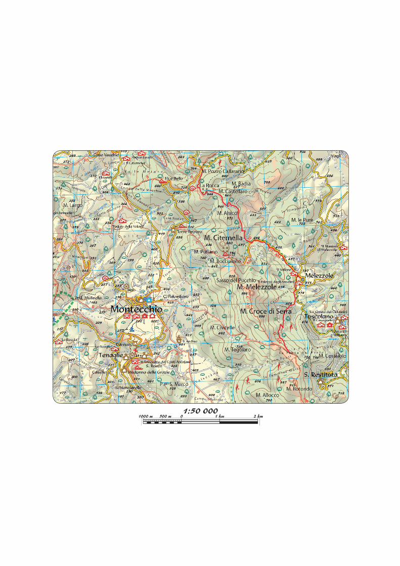
Montecchio Percorso D / Trail D of Montecchio M. POZZO CALLARANO, MELEZZOLE, LA POSTA DEL PRETE Km: 7,600 - Ore / Duration: 3 00’ - Diff. E - á 315 - â 241 Dal quadrivio posto incrocio tra la SP Montecchio-Todi e la SP per Civitella si prende in salita una strada silvopastorale che raggiunge la sella tra il Monte Castellaro e il Monte Alsicci dopo essere passati nei pressi delle rovine de La Rocca a quota 844. La strada scende, aggira verso est il M. Alsicci e, dopo aver in- tercettato un’altra sterrata che si segue a destra, con una breve salita raggiunge la carrozzabile che collega Montecchio a Me- lezzole. Si prosegue a sinistra in discesa, si supera il cimitero di Melezzole e si raggiunge l’asfaltata nei pressi dell’ingresso del centro storico di Melezzole. Si prosegue sull’asfaltata a destra e all’altezza di un incrocio si prende a destra una ripida strada bianca in salita (indicazioni per Chiesa di San Vitale in Villamu- rellis) che sale, con alcune svolte, a mezzacosta in direzione Sud sulle pendici del M. Croce di Serra e raggiunge, tenendosi a destra al primo bivio, l’ampia sella erbosa di Piano Puosi, in località Posta del Prete, ai piedi del M. Rotondo. From the four-way intersection between the SP Montecchio-Todi and the SP for Civitella take the upward silvopastoral road that reaches the saddle between Mount Castellaro and Mount Alsic- ci after passing near the ruins of La Rocca (844 m. amsl). The road descends, moves around Mount Alsicci to the east and meets another trail which you follow on the right; after a brief climb you will reach the driving road connecting Montecchio to Melezzole. Continue downhill on the left, pass the cemetery of Melezzole and reach the tarmac road near the entrance of the historic centre of Melezzole. Follow this road on the right and at an intersection take a steep unsurfaced uphill road on the right (there are indications for the Church of San Vitale in Villamurel- lis) which rises, with a few bends, halfway up the slope of Mount Croce di Serra towards the south; keeping to the right at the first fork, you reach the ample grassy saddle of Piano Puosi, in locality Posta del Prete, at the foot of Mount Rotondo. Regione Umbria Disclaimer Il grafico altimetrico degli itinerari e il suo sviluppo, sono qui presentati in forma sintetica, per facilitarne la comprensione. Per lo sviluppo altimetrico esatto fa fede la traccia GPS scaricabile dal sito. Tanto le tracce gps che i testi e gli stralci di cartografie qui pubblicati sono di proprietà della Regione Umbria. Testi e stralci di cartografie possono essere liberamente riprodotti ed archiviati nel proprio pc nell’ambito di utilizzo personale degli stessi, ed altri utilizzi sono consentiti solo dietro autorizzazione scritta dell’Ente. Le tracce gps sono invece rilasciate con licenza ODbL 1.0 license il cui testo integrale ti preghiamo di consultare prima di utilizzi diversi da quello personale su www.opendatacommons.org/licenses/odbl/1-0/. The following is a simplified altimetry chart, in order to make its reading easier. For more detailed altimetry data the GPS chart can be downloaded from the website. The GPS data, the texts and the map excerpts all belong to Umbria Region; although the texts and the maps may be freely copied and archived in personal computers for private use, any other use is subject to a previous authorization by the regional institution. The GPS data are available through ODbL 1.0 license: it is strongly advised to read the full text of this license before any other-than-private use of the data: www.opendatacommons.org/licenses/odbl/1-0/. 1 km
Transcript of Regione Umbria Montecchio Percorso D / Trail D of Montecchio M

Montecchio Percorso D / Trail D of MontecchioM. POZZO CALLARANO, MELEZZOLE, LA POSTA DEL PRETEKm: 7,600 - Ore / Duration: 3 00’ - Diff. E - á 315 - â 241
Dal quadrivio posto incrocio tra la SP Montecchio-Todi e la SP per Civitella si prende in salita una strada silvopastorale che raggiunge la sella tra il Monte Castellaro e il Monte Alsicci dopo essere passati nei pressi delle rovine de La Rocca a quota 844. La strada scende, aggira verso est il M. Alsicci e, dopo aver in-tercettato un’altra sterrata che si segue a destra, con una breve salita raggiunge la carrozzabile che collega Montecchio a Me-lezzole. Si prosegue a sinistra in discesa, si supera il cimitero di Melezzole e si raggiunge l’asfaltata nei pressi dell’ingresso del centro storico di Melezzole. Si prosegue sull’asfaltata a destra e all’altezza di un incrocio si prende a destra una ripida strada bianca in salita (indicazioni per Chiesa di San Vitale in Villamu-rellis) che sale, con alcune svolte, a mezzacosta in direzione Sud sulle pendici del M. Croce di Serra e raggiunge, tenendosi a destra al primo bivio, l’ampia sella erbosa di Piano Puosi, in località Posta del Prete, ai piedi del M. Rotondo.
From the four-way intersection between the SP Montecchio-Todi and the SP for Civitella take the upward silvopastoral road that reaches the saddle between Mount Castellaro and Mount Alsic-ci after passing near the ruins of La Rocca (844 m. amsl). The road descends, moves around Mount Alsicci to the east and meets another trail which you follow on the right; after a brief climb you will reach the driving road connecting Montecchio to Melezzole. Continue downhill on the left, pass the cemetery of Melezzole and reach the tarmac road near the entrance of the historic centre of Melezzole. Follow this road on the right and at an intersection take a steep unsurfaced uphill road on the right (there are indications for the Church of San Vitale in Villamurel-lis) which rises, with a few bends, halfway up the slope of Mount Croce di Serra towards the south; keeping to the right at the first fork, you reach the ample grassy saddle of Piano Puosi, in locality Posta del Prete, at the foot of Mount Rotondo.
Regione Umbria
DisclaimerIl grafico altimetrico degli itinerari e il suo sviluppo, sono qui presentati in forma sintetica, per facilitarne la comprensione. Per lo sviluppo altimetrico esatto fa fede la traccia GPS scaricabile dal sito. Tanto le tracce gps che i testi e gli stralci di cartografie qui pubblicati sono di proprietà della Regione Umbria. Testi e stralci di cartografie possono essere liberamente riprodotti ed archiviati nel proprio pc nell’ambito di utilizzo personale degli stessi, ed altri utilizzi sono consentiti solo dietro autorizzazione scritta dell’Ente. Le tracce gps sono invece rilasciate con licenza ODbL 1.0 license il cui testo integrale ti preghiamo di consultare prima di utilizzi diversi da quello personale su www.opendatacommons.org/licenses/odbl/1-0/.The following is a simplified altimetry chart, in order to make its reading easier. For more detailed altimetry data the GPS chart can be downloaded from the website. The GPS data, the texts and the map excerpts all belong to Umbria Region; although the texts and the maps may be freely copied and archived in personal computers for private use, any other use is subject to a previous authorization by the regional institution. The GPS data are available through ODbL 1.0 license: it is strongly advised to read the full text of this license before any other-than-private use of the data: www.opendatacommons.org/licenses/odbl/1-0/.
1 km