PROVINCIADICOMO AssessoratoalTurismo LAKE COMO sito turistico/TREKKING ING.pdf · PROVINCIADICOMO...
36
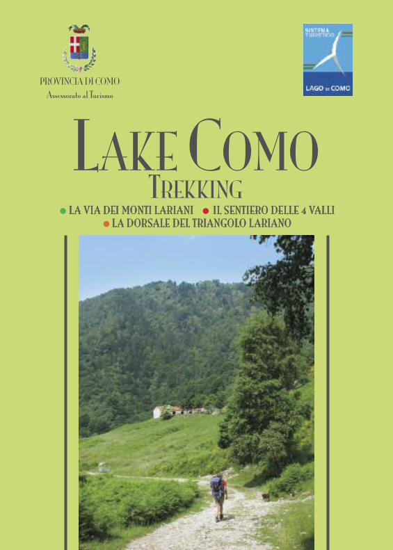
LAKE COMO TREKKING PROVINCIA DI COMO Assessorato al Turismo • LA VIA DEI MONTI LARIANI • IL SENTIERO DELLE 4 VALLI • LA DORSALE DEL TRIANGOLO LARIANO
Transcript of PROVINCIADICOMO AssessoratoalTurismo LAKE COMO sito turistico/TREKKING ING.pdf · PROVINCIADICOMO...
LAKE COMOTREKKING
PROVINCIA DI COMOAssessorato al Turismo
• LLAA VVIIAA DDEEII MMOONNTTII LLAARRIIAANNII • IILL SSEENNTTIIEERROO DDEELLLLEE 44 VVAALLLLII
• LLAA DDOORRSSAALLEE DDEELL TTRRIIAANNGGOOLLOO LLAARRIIAANNOO
USEFUL TELEPHONE NUMBERS Tourist Boards: Uffcio I.A.T. Como – 22100 Como – Piazza Cavour 17 - tel. 031 269712 - www.lakecomo.itUfficio I.A.T. Menaggio - 22017 Menaggio (CO) - Piazza Garibaldi 4 - tel. 0344 32924 - www.menaggio.comUfficio I.A.T. Bellagio - 22021 Bellagio - P.zza Mazzini - tel. 031 950204 - www.bellagiolakecomo.comComunità Montana Triangolo Lariano - 22035 Canzo - via Vittorio Veneto 16 - tel. 031 672000Comunità Montana Alpi Lepontine - 22018 Porlezza - Via Cuccio, 8 - tel. 0344 62427Comunità Montana Alto Lario - 22015 Gravedona - Via Regina Lavente 2 - tel. 0344 85.218Comunità Montana Lario Intelvese - 22028 S. Fedele Intelvi - Via Roma 9 - tel. 031 830741Weather forecast 848837077 - www.centrometeolombardo.comSoccorso Alpino (First Aid) - 118ASF Autolinee (Bus lines) - tel. 031 247111 - www.sptlinea.itNavigazione Lago di Como (boat lines) - tel. 031 579211 - www.navigazionelaghi.itFunicular Como-Brunate - tel. 031 303608 - www.funicolarecomo.it
We advise to ask for the following additional information: an accommodation list of lake Como, a bus and a boat time table.
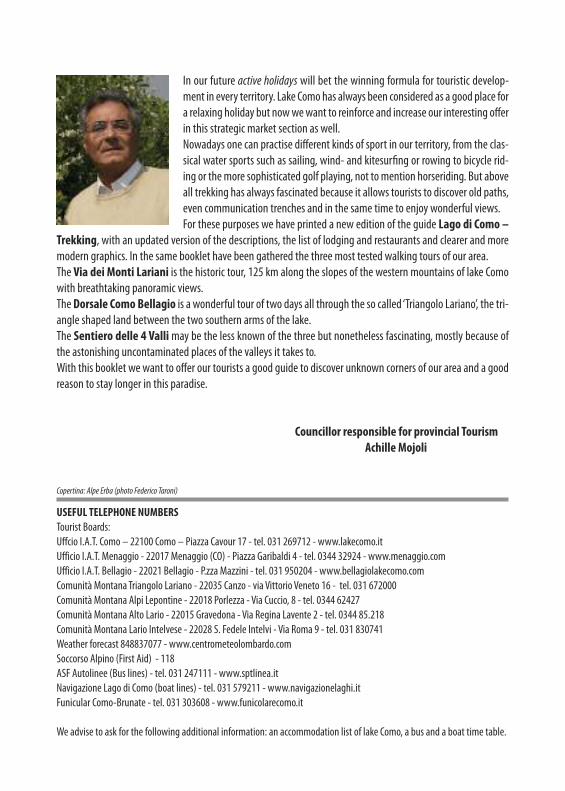
In our future active holidays will bet the winning formula for touristic develop-ment in every territory. Lake Como has always been considered as a good place fora relaxing holiday but now we want to reinforce and increase our interesting offerin this strategic market section as well.Nowadays one can practise different kinds of sport in our territory, from the clas-sical water sports such as sailing, wind- and kitesurfing or rowing to bicycle rid-ing or the more sophisticated golf playing, not to mention horseriding. But aboveall trekking has always fascinated because it allows tourists to discover old paths,even communication trenches and in the same time to enjoy wonderful views.For these purposes we have printed a new edition of the guide Lago di Como –
Trekking, with an updated version of the descriptions, the list of lodging and restaurants and clearer and moremodern graphics. In the same booklet have been gathered the three most tested walking tours of our area.The Via dei Monti Lariani is the historic tour, 125 km along the slopes of the western mountains of lake Comowith breathtaking panoramic views.The Dorsale Como Bellagio is a wonderful tour of two days all through the so called ‘Triangolo Lariano’, the tri-angle shaped land between the two southern arms of the lake.The Sentiero delle 4 Vallimay be the less known of the three but nonetheless fascinating, mostly because ofthe astonishing uncontaminated places of the valleys it takes to.With this booklet we want to offer our tourists a good guide to discover unknown corners of our area and a goodreason to stay longer in this paradise.
Councillor responsible for provincial TourismAchille Mojoli
Copertina: Alpe Erba (photo Federico Taroni)
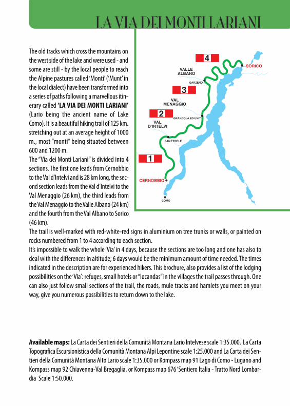
The old tracks which cross the mountains onthe west side of the lake and were used - andsome are still - by the local people to reachthe Alpine pastures called ‘Monti’ (‘Munt’ inthe local dialect) have been transformed intoa series of paths following a marvellous itin-erary called ‘LA VIA DEI MONTI LARIANI’(Lario being the ancient name of LakeComo). It is a beautiful hiking trail of 125 km.stretching out at an average height of 1000m., most “monti” being situated between600 and 1200 m.The “Via dei Monti Lariani” is divided into 4sections. The first one leads from Cernobbioto the Val d’Intelvi and is 28 km long, the sec-ond section leads from the Val d’Intelvi to theVal Menaggio (26 km), the third leads fromthe Val Menaggio to the Valle Albano (24 km)and the fourth from the Val Albano to Sorico(46 km).The trail is well-marked with red-white-red signs in aluminium on tree trunks or walls, or painted onrocks numbered from 1 to 4 according to each section.It’s impossible to walk the whole ‘Via’ in 4 days, because the sections are too long and one has also todeal with the differences in altitude; 6 days would be the minimum amount of time needed. The timesindicated in the description are for experienced hikers. This brochure, also provides a list of the lodgingpossibilities on the ‘Via’: refuges, small hotels or “locandas” in the villages the trail passes through. Onecan also just follow small sections of the trail, the roads, mule tracks and hamlets you meet on yourway, give you numerous possibilities to return down to the lake.
Available maps: La Carta dei Sentieri della Comunità Montana Lario Intelvese scale 1:35.000, La CartaTopografica Escursionistica della Comunità Montana Alpi Lepontine scale 1:25.000 and La Carta dei Sen-tieri della Comunità Montana Alto Lario scale 1:35.000 or Kompass map 91 Lago di Como - Lugano andKompass map 92 Chiavenna-Val Bregaglia, or Kompass map 676 ‘Sentiero Italia - Tratto Nord Lombar-dia Scale 1:50.000.
CERNOBBIO
VALD’INTELVI
VALMENAGGIO
VALLEALBANO
GRANDOLA ED UNITI
SAN FEDELE
GARZENO
COMO
SORICO
VAL D’INTELVI
CERNOBBIO
M. GENEROSOm 1.701
P. DELLA CROCEm 1.492
SASSO GORDONAm 1.410
M. BISBINOm 1.325
M. COLMEGNONEm 1.383
R
ALPE DI CARATEm 1.270
COLMADEL CRINCO
m 1.204
CAP. BRUNOC.A.I
m 1.180
RIF. CRISTÈC.A.I
m 1.129
M.TICAROLZA
m 1.110
PIAN DELLE ALPIm 1.000
RIF. PRABELLOC.A.I.
m 1.200
M.TI MADRONAm 850
M.TI SCARONEm 600
ROVENNAm 450
CÀ BOSSIm 1.150
RIF.DEL BUGONE
m 1.119
RIF. MURELLIC.A.I.
m 1.200
S. BERNARDO
RIF. BINATEC.A.I.
m 1.250
COLMA DI SCHIGNANO
m 202
ALPE D’ORIMENTOm 1.276
CARATE URIO
MOLTRASIO
BRIENNO
ARGEGNO
COMO
SCHIGNANO600
m 779SAN FEDELE
CASASCOm 822
ERBONNE
BELLAGIO
OSTE
NO
MENAGGIO
M. GALBIGAm 1.698
RIF. VENINIm 1.576
M. DI LENNOm 1.589
M. CROCIONEm 1.641
ALPE GADAm 1.260
PIAZZAm 1.200
GARBAGNOm 1.150
PAULLOm 580
BOCCHETTADI NAVAm 848M.TI DI
DI NAVAm 885
M.TI DIBRENTEm 1.000
RIF. BOFFALORAm 1.252
ALPE DI COLONNOm 1.300
BASSETTA BASSAm 1.200
LA ZERLAm 1.172
COLAm 1.000
BELVEDEREm 940
ALPE DI COLAm 1.100
M. COSTONEm 1.441
m 881
m 270
CIMAD. DUARIA
m 1.441
S.BENEDETTOm 800 NARRO
m 950
M.TI OSSINOm 1.010
GALLERIA1915-18m 1.100PIODA
m 1.256R
R
LAINO
OSTENO
PIGRA
OSSUCCIOLENNO
TREMEZZO
GRIANTE
MENAGGIO
m 779
ARGEGNO
m 202
SAN FEDELE
m 676
m 272
m 202
VAL D’INTELVI
m 385
PORLEZZA
VAL MENAGGIO
GRANDOLAED UNITI
CROCE
M. DI TREMEZZOm 1.700
COM
O
DONG
O
LUGANO
M. DI TREMEZZO
S.BENEDETTOm 800
m 1.700
M. COSTONEm 1.441
GRANDOLAED UNITI
CROCE
M. BREGAGNOm 2.107
PIAZZEm 765
M.TI NAROm 1.190
S. DOMENICOm 1.115
MONTUGLIOm 1.000
M.TI DI TRECCIONEm 938
M.TI DI CARCENTEm 883
RIF. MENAGGIOC.A.I.
m 1.400R
M. GRONAm 1.736
PRATO STELLA
LA PIAZZAm 747
BARNAm 500
CARCENTEm 700
BREGLIAm 750
M.TI BRACCOm 1.069
M.TI PIAZZUCCOm 1.170
ALP DE NENCIMm 1.200
LABBIOm 1.080
S. BERNARDOm 1.105
m 380
CATASCO
GRAVEDONA
DONGO
MUSSO
PIANELLO
CREMIA
REZZONICO
ACQUASERIA
MENAGGIOCROCEGRANDOLA
ED UNITI
PORLEZZAVAL
MENAGGIO
GARZENO662
BRENZEGLIO
RIF. GIOVOC.A.I.
RIF. SOMMMAFIUMEC.A.I.
COM
O
OSTENO
SORICO
ALTA VIA DEL LARIO
SENTIERO DELLEQUATTRO VALLI 3
VALLE ALBANO
CHIA
VENN
A
M. DURIAm 2.269
M. DELLA CROCEm 1.887
M.BERLINGHERA
RIF. COMOC.A.I.
m 1.781
MADONNADI LIVIOm 742
BARROm 620
PONTE DIDANGRIm 659
CASNIOLOm 702PONTE
DI VINCINOm 820RIF. VINCINO
m. 1.071
TARÙNm. 960
PUNT DÈBUDANGHEL
m. 981
BADALUCCOm. 940
L’AGNUNm. 920
CARZAN
NESSAm. 840
PIAZZAm 980
IEVIAm 810
CAGNAOm 885
S. ANNAm 818
L’AVOLOm 865
m 662
LIVOm. 675
DOSSODEL LIRO
m. 625
PEGLIOm. 633
S. GIACOMOm. 697
TROBBIOm. 940
PUIIm. 800
TABBIADELLOm. 950
S. BARTOLOMEOm. 1.024
FORDECCIAm. 1.100
SASSOLTm. 950
S. MIROm. 300
m. 202
MONTALTOm. 1.030
R
R
DONGO
CONSIGLIORUMO
GRAVEDONA
DOMASO
COLICO
GERA
ALTA VIA DEL LARIO
VALLE ALBANO
GARZENO
SORICOSORICO
RIF. GIOVO
LECC
O
MENA
GGIO
1
2
3
4
1
23
4
BUS
BUS
BUS
BUS
BUS
R
R
R
BUS
BUS
BUS
BUS
BUS
BUS
S. ANNAm 818
BUS
BUS BUS
BUSBUS
RIF. ALPINOD’ALCOm. 1.000
RIF. ALPINOD’ALCOm. 1.000
RIF. LAGO DARENGOm 1.775 RIF. PIANEZZA
m 1.250
OSSUCCIO
PLESIO
PIAN DELLE ALPIm 1.000
CAGNAOm 885
DONGO
CONSIGLIO RUMO
GRAVEDONA
DOMASO
GERA
LA VIA DEI MONTI LARIANI
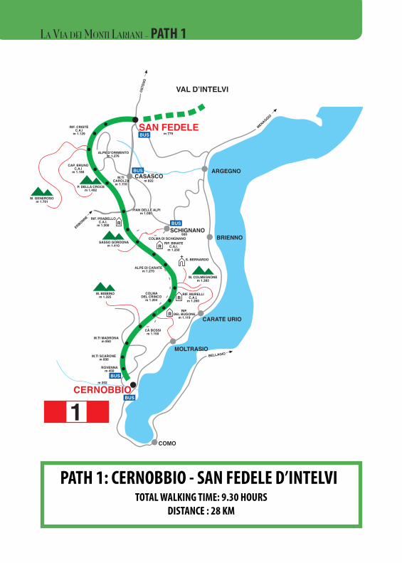
PATH 1: CERNOBBIO - SAN FEDELE D’INTELVITOTAL WALKING TIME: 9.30 HOURS
DISTANCE : 28 KM
CERNOBBIO
VALD’INTELVI
VALMENAGGIO
VALLEALBANO
GRANDOLA ED UNITI
SAN FEDELE
GARZENO
COMO
SORICO
VAL D’INTELVI
CERNOBBIO
M. GENEROSOm 1.701
P. DELLA CROCEm 1.492
SASSO GORDONAm 1.410
M. BISBINOm 1.325
M. COLMEGNONEm 1.383
R
ALPE DI CARATEm 1.270
COLMADEL CRINCO
m 1.204
CAP. BRUNOC.A.I
m 1.180
RIF. CRISTÈC.A.I
m 1.129
M.TICAROLZA
m 1.110
PIAN DELLE PIAN DELLE ALPIALPIm 1.000m 1.000
RIF. PRABELLOC.A.I.
m 1.200
M.TI MADRONAm 850
M.TI SCARONEm 600
ROVENNAm 450
CÀ BOSSIm 1.150
RIF.DEL BUGONE
m 1.119
RIF. MURELLIC.A.I.
m 1.200
S. BERNARDO
RIF. BINATEC.A.I.
m 1.250
COLMA DI SCHIGNANO
m 202
ALPE D’ORIMENTOm 1.276
CARATE URIO
MOLTRASIO
BRIENNO
ARGEGNO
COMO
SCHIGNANO600
m 779SAN FEDELE
CASASCOm 822
ERBONNE
BELLAGIO
OSTE
NO
MENAGGIO
M. GALBIGAm 1.698
RIF. VENINIm 1.576
M. DI LENNOm 1.589
M. CROCIONEm 1.641
ALPE GADAm 1.260
PIAZZAm 1.200
GARBAGNOm 1.150
PAULLOm 580
BOCCHETTADI NAVAm 848M.TI DI
DI NAVAm 885
M.TI DIBRENTEm 1.000
RIF. BOFFALORAm 1.252
ALPE DI COLONNOm 1.300
BASSETTA BASSAm 1.200
LA ZERLAm 1.172
COLAm 1.000
BELVEDEREm 940
ALPE DI COLAm 1.100
M. COSTONEm 1.441
m 881
m 270
CIMAD. DUARIA
m 1.441
S.BENEDETTOm 800 NARRO
m 950
M.TI OSSINOm 1.010
GALLERIA1915-18m 1.100PIODA
m 1.256R
R
LAINO
OSTENO
PIGRA
OSSUCCIOLENNO
TREMEZZO
GRIANTE
MENAGGIO
m 779
ARGEGNO
m 202
SAN FEDELE
m 676
m 272
m 202
VAL D’INTELVI
m 385
PORLEZZA
VAL MENAGGIO
GRANDOLAED UNITI
CROCE
M. DI TREMEZZOm 1.700
COM
O
DONG
O
LUGANO
M. DI TREMEZZO
S.BENEDETTOm 800
m 1.700
M. COSTONEm 1.441
GRANDOLAED UNITI
CROCE
M. BREGAGNOm 2.107
PIAZZEm 765
M.TI NAROm 1.190
S. DOMENICOm 1.115
MONTUGLIOm 1.000
M.TI DI TRECCIONEm 938
M.TI DI CARCENTEm 883
RIF. MENAGGIOC.A.I.
m 1.400R
M. GRONAm 1.736
PRATO STELLA
LA PIAZZAm 747
BARNAm 500
CARCENTEm 700
BREGLIAm 750
M.TI BRACCOm 1.069
M.TI PIAZZUCCOm 1.170
ALP DE NENCIMm 1.200
LABBIOm 1.080
S. BERNARDOm 1.105
m 380
CATASCO
GRAVEDONA
DONGO
MUSSO
PIANELLO
CREMIA
REZZONICO
ACQUASERIA
MENAGGIOCROCEGRANDOLA
ED UNITI
PORLEZZAVAL
MENAGGIO
GARZENO662
BRENZEGLIO
RIF. GIOVOC.A.I.
RIF. SOMMMAFIUMEC.A.I.
COM
O
OSTENO
SORICO
ALTA VIA DEL LARIO
SENTIERO DELLEQUATTRO VALLI 3
VALLE ALBANO
CHIA
VENN
A
M. DURIAm 2.269
M. DELLA CROCEm 1.887
M.BERLINGHERA
RIF. COMOC.A.I.
m 1.781
MADONNADI LIVIOm 742
BARROm 620
PONTE DIDANGRIm 659
CASNIOLOm 702PONTE
DI VINCINOm 820RIF. VINCINO
m. 1.071
TARÙNm. 960
PUNT DÈBUDANGHEL
m. 981
BADALUCCOm. 940
L’AGNUNm. 920
CARZAN
NESSAm. 840
PIAZZAm 980
IEVIAm 810
CAGNAOm 885
S. ANNAm 818
L’AVOLOm 865
m 662
LIVOm. 675
DOSSODEL LIRO
m. 625
PEGLIOm. 633
S. GIACOMOm. 697
TROBBIOm. 940
PUIIm. 800
TABBIADELLOm. 950
S. BARTOLOMEOm. 1.024
FORDECCIAm. 1.100
SASSOLTm. 950
S. MIROm. 300
m. 202
MONTALTOm. 1.030
R
R
DONGO
CONSIGLIORUMO
GRAVEDONA
DOMASO
COLICO
GERA
ALTA VIA DEL LARIO
VALLE ALBANO
GARZENO
SORICOSORICO
RIF. GIOVO
LECC
O
MENA
GGIO
1
2
3
4
1
23
4
BUS
BUS
BUS
BUS
BUS
R
R
R
BUS
BUS
BUS
BUS
BUS
BUS
S. ANNAm 818
BUS
BUS BUS
BUSBUS
RIF. ALPINOD’ALCOm. 1.000
RIF. ALPINOD’ALCOm. 1.000
RIF. LAGO DARENGOm 1.775 RIF. PIANEZZA
m 1.250
OSSUCCIO
PLESIO
PIAN DELLE ALPIm 1.000
CAGNAOm 885
DONGO
CONSIGLIO RUMO
GRAVEDONA
DOMASO
GERA
LA VIA DEI MONTI LARIANI - PATH 1
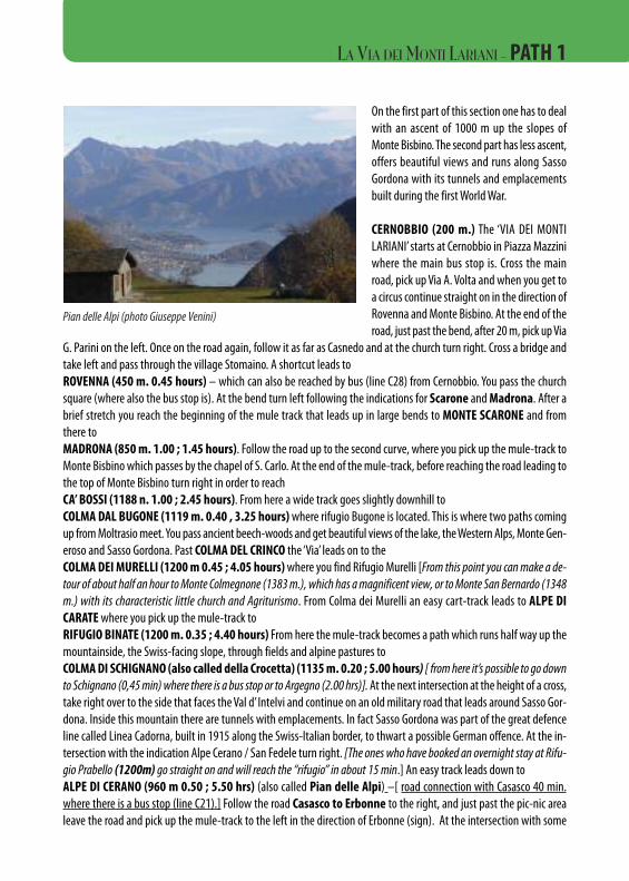
On the first part of this section one has to dealwith an ascent of 1000 m up the slopes ofMonte Bisbino. The second part has less ascent,offers beautiful views and runs along SassoGordona with its tunnels and emplacementsbuilt during the first World War.
CERNOBBIO (200 m.) The ‘VIA DEI MONTILARIANI’ starts at Cernobbio in Piazza Mazziniwhere the main bus stop is. Cross the mainroad, pick up Via A. Volta and when you get toa circus continue straight on in the direction ofRovenna and Monte Bisbino. At the end of theroad, just past the bend, after 20 m, pick up Via
G. Parini on the left. Once on the road again, follow it as far as Casnedo and at the church turn right. Cross a bridge andtake left and pass through the village Stomaino. A shortcut leads toROVENNA (450 m. 0.45 hours) – which can also be reached by bus (line C28) from Cernobbio. You pass the churchsquare (where also the bus stop is). At the bend turn left following the indications for Scarone and Madrona. After abrief stretch you reach the beginning of the mule track that leads up in large bends to MONTE SCARONE and fromthere toMADRONA (850 m. 1.00 ; 1.45 hours). Follow the road up to the second curve, where you pick up the mule-track toMonte Bisbino which passes by the chapel of S. Carlo. At the end of the mule-track, before reaching the road leading tothe top of Monte Bisbino turn right in order to reach CA’ BOSSI (1188 n. 1.00 ; 2.45 hours). From here a wide track goes slightly downhill to COLMA DAL BUGONE (1119m. 0.40 , 3.25 hours)where rifugio Bugone is located. This is where two paths comingup from Moltrasio meet. You pass ancient beech-woods and get beautiful views of the lake, the Western Alps, Monte Gen-eroso and Sasso Gordona. Past COLMA DEL CRINCO the ‘Via’ leads on to the COLMA DEI MURELLI (1200 m 0.45 ; 4.05 hours)where you find Rifugio Murelli [From this point you can make a de-tour of about half an hour to Monte Colmegnone (1383 m.), which has a magnificent view, or to Monte San Bernardo (1348m.) with its characteristic little church and Agriturismo. From Colma dei Murelli an easy cart-track leads to ALPE DICARATEwhere you pick up the mule-track toRIFUGIO BINATE (1200 m. 0.35 ; 4.40 hours) From here the mule-track becomes a path which runs half way up themountainside, the Swiss-facing slope, through fields and alpine pastures to COLMA DI SCHIGNANO (also called della Crocetta) (1135 m. 0.20 ; 5.00 hours) [ from here it’s possible to go downto Schignano (0,45 min) where there is a bus stop or to Argegno (2.00 hrs)]. At the next intersection at the height of a cross,take right over to the side that faces the Val d’ Intelvi and continue on an old military road that leads around Sasso Gor-dona. Inside this mountain there are tunnels with emplacements. In fact Sasso Gordona was part of the great defenceline called Linea Cadorna, built in 1915 along the Swiss-Italian border, to thwart a possible German offence. At the in-tersection with the indication Alpe Cerano / San Fedele turn right. [The ones who have booked an overnight stay at Rifu-gio Prabello (1200m) go straight on and will reach the “rifugio” in about 15 min.] An easy track leads down to ALPE DI CERANO (960 m 0.50 ; 5.50 hrs) (also called Pian delle Alpi) –[ road connection with Casasco 40 min.where there is a bus stop (line C21).] Follow the road Casasco to Erbonne to the right, and just past the pic-nic arealeave the road and pick up the mule-track to the left in the direction of Erbonne (sign). At the intersection with some
Pian delle Alpi (photo Giuseppe Venini)
LA VIA DEI MONTI LARIANI - PATH 1
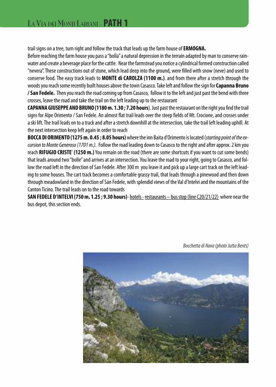
trail signs on a tree, turn right and follow the track that leads up the farm house of ERMOGNA. Before reaching the farm house you pass a “bolla” a natural depression in the terrain adapted by man to conserve rain-water and create a beverage place for the cattle. Near the farmstead you notice a cylindrical formed construction called“nevera”. These constructions out of stone, which lead deep into the ground, were filled with snow (neve) and used toconserve food. The easy track leads to MONTE di CAROLZA (1100 m.). and from there after a stretch through thewoods you reach some recently built houses above the town Casasco. Take left and follow the sign for Capanna Bruno/ San Fedele. Then you reach the road coming up from Casasco, follow it to the left and just past the bend with threecrosses, leave the road and take the trail on the left leading up to the restaurantCAPANNA GIUSEPPE AND BRUNO (1180 m. 1.30 ; 7.20 hours). Just past the restaurant on the right you find the trailsigns for Alpe Orimento / San Fedele. An almost flat trail leads over the steep fields of Mt. Crocione, and crosses undera ski lift. The trail leads on to a track and after a stretch downhill at the intersection, take the trail left leading uphill. Atthe next intersection keep left again in order to reachBOCCA DI ORIMENTO (1275 m. 0.45 ; 8.05 hours)where the inn Baita d’Orimento is located (starting point of the ex-cursion to Monte Generoso (1701 m.). Follow the road leading down to Casasco to the right and after approx. 2 km youreach RIFUGIO CRISTE‘ (1250 m.) You remain on the road (there are some shortcuts if you want to cut some bends)that leads around two “bolle” and arrives at an intersection. You leave the road to your right, going to Casasco, and fol-low the road left in the direction of San Fedele. After 300 m you leave it and pick up a large cart track on the left lead-ing to some houses. The cart track becomes a comfortable grassy trail, that leads through a pinewood and then downthrough meadowland in the direction of San Fedele, with splendid views of the Val d’Intelvi and the mountains of theCanton Ticino. The trail leads on to the road towardsSAN FEDELE D’INTELVI (750 m. 1.25 ; 9.30 hours)- hotels - restaurants – bus stop (line C20/21/22) where near thebus depot, this section ends.
Bocchetta di Nava (photo Jutta Bents)
LA VIA DEI MONTI LARIANI - PATH 1
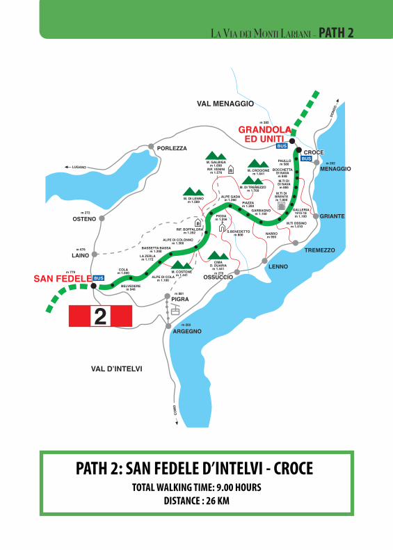
PATH 2: SAN FEDELE D’INTELVI - CROCETOTAL WALKING TIME: 9.00 HOURS
DISTANCE : 26 KM
CERNOBBIO
VALD’INTELVI
VALMENAGGIO
VALLEALBANO
GRANDOLA ED UNITI
SAN FEDELE
GARZENO
COMO
SORICO
VAL D’INTELVI
CERNOBBIO
M. GENEROSOm 1.701
P. DELLA CROCEm 1.492
SASSO GORDONAm 1.410
M. BISBINOm 1.325
M. COLMEGNONEm 1.383
R
ALPE DI CARATEm 1.270
COLMADEL CRINCO
m 1.204
CAP. BRUNOC.A.I
m 1.180
RIF. CRISTÈC.A.I
m 1.129
M.TICAROLZA
m 1.110
PIAN DELLE ALPIm 1.000
RIF. PRABELLOC.A.I.
m 1.200
M.TI MADRONAm 850
M.TI SCARONEm 600
ROVENNAm 450
CÀ BOSSIm 1.150
RIF.DEL BUGONE
m 1.119
RIF. MURELLIC.A.I.
m 1.200
S. BERNARDO
RIF. BINATEC.A.I.
m 1.250
COLMA DI SCHIGNANO
m 202
ALPE D’ORIMENTOm 1.276
CARATE URIO
MOLTRASIO
BRIENNO
ARGEGNO
COMO
SCHIGNANO600
m 779SAN FEDELE
CASASCOm 822
ERBONNE
BELLAGIO
OSTE
NO
MENAGGIO
M. GALBIGAm 1.698
RIF. VENINIm 1.576
M. DI LENNOm 1.589
M. CROCIONEm 1.641
ALPE GADAm 1.260
PIAZZAm 1.200
GARBAGNOm 1.150
PAULLOm 580
BOCCHETTADI NAVAm 848M.TI DI
DI NAVAm 885
M.TI DIBRENTEm 1.000
RIF. BOFFALORAm 1.252
ALPE DI COLONNOm 1.300
BASSETTA BASSAm 1.200
LA ZERLAm 1.172
COLAm 1.000
BELVEDEREm 940
ALPE DI COLAm 1.100
M. COSTM. COSTONEONEm 1.441m 1.441
m 881
m 270
CIMAD. DUARIA
m 1.441
S.BENEDETTS.BENEDETTOOm 800m 800 NARRO
m 950
M.TI OSSINOm 1.010
GALLERIA1915-18m 1.100PIODA
m 1.256R
R
LAINO
OSTENO
PIGRA
OSSUCCIOOSSUCCIOLENNO
TREMEZZO
GRIANTE
MENAGGIO
m 779
ARGEGNO
m 202
SAN FEDELE
m 676
m 272
m 202
VAL D’INTELVI
m 385
PORLEZZA
VAL MENAGGIO
GGRRAANNDDOOLLAAEEDD UUNNIITTII
CROCECROCE
M. DI M. DI TREMEZZOTREMEZZOm 1.700m 1.700
COM
O
DONG
O
LUGANO
M. DI TREMEZZO
S.BENEDETTOm 800
m 1.700
M. COSTONEm 1.441
GRANDOLAED UNITI
CROCE
M. BREGAGNOm 2.107
PIAZZEm 765
M.TI NAROm 1.190
S. DOMENICOm 1.115
MONTUGLIOm 1.000
M.TI DI TRECCIONEm 938
M.TI DI CARCENTEm 883
RIF. MENAGGIOC.A.I.
m 1.400R
M. GRONAm 1.736
PRATO STELLA
LA PIAZZAm 747
BARNAm 500
CARCENTEm 700
BREGLIAm 750
M.TI BRACCOm 1.069
M.TI PIAZZUCCOm 1.170
ALP DE NENCIMm 1.200
LABBIOm 1.080
S. BERNARDOm 1.105
m 380
CATASCO
GRAVEDONA
DONGO
MUSSO
PIANELLO
CREMIA
REZZONICO
ACQUASERIA
MENAGGIOCROCEGRANDOLA
ED UNITI
PORLEZZAVAL
MENAGGIO
GARZENO662
BRENZEGLIO
RIF. GIOVOC.A.I.
RIF. SOMMMAFIUMEC.A.I.
COM
O
OSTENO
SORICO
ALTA VIA DEL LARIO
SENTIERO DELLEQUATTRO VALLI 3
VALLE ALBANO
CHIA
VENN
A
M. DURIAm 2.269
M. DELLA CROCEm 1.887
M.BERLINGHERA
RIF. COMOC.A.I.
m 1.781
MADONNADI LIVIOm 742
BARROm 620
PONTE DIDANGRIm 659
CASNIOLOm 702PONTE
DI VINCINOm 820RIF. VINCINO
m. 1.071
TARÙNm. 960
PUNT DÈBUDANGHEL
m. 981
BADALUCCOm. 940
L’AGNUNm. 920
CARZAN
NESSAm. 840
PIAZZAm 980
IEVIAm 810
CAGNAOm 885
S. ANNAm 818
L’AVOLOm 865
m 662
LIVOm. 675
DOSSODEL LIRO
m. 625
PEGLIOm. 633
S. GIACOMOm. 697
TROBBIOm. 940
PUIIm. 800
TABBIADELLOm. 950
S. BARTOLOMEOm. 1.024
FORDECCIAm. 1.100
SASSOLTm. 950
S. MIROm. 300
m. 202
MONTALTOm. 1.030
R
R
DONGO
CONSIGLIORUMO
GRAVEDONA
DOMASO
COLICO
GERA
ALTA VIA DEL LARIO
VALLE ALBANO
GARZENO
SORICOSORICO
RIF. GIOVO
LECC
O
MENA
GGIO
1
2
3
4
1
23
4
BUS
BUS
BUS
BUS
BUS
R
R
R
BUS
BUS
BUS
BUS
BUS
BUS
S. ANNAm 818
BUS
BUS BUS
BUSBUS
RIF. ALPINOD’ALCOm. 1.000
RIF. ALPINOD’ALCOm. 1.000
RIF. LAGO DARENGOm 1.775 RIF. PIANEZZA
m 1.250
OSSUCCIO
PLESIO
PIAN DELLE ALPIm 1.000
CAGNAOm 885
DONGO
CONSIGLIO RUMO
GRAVEDONA
DOMASO
GERA
LA VIA DEI MONTI LARIANI - PATH 2
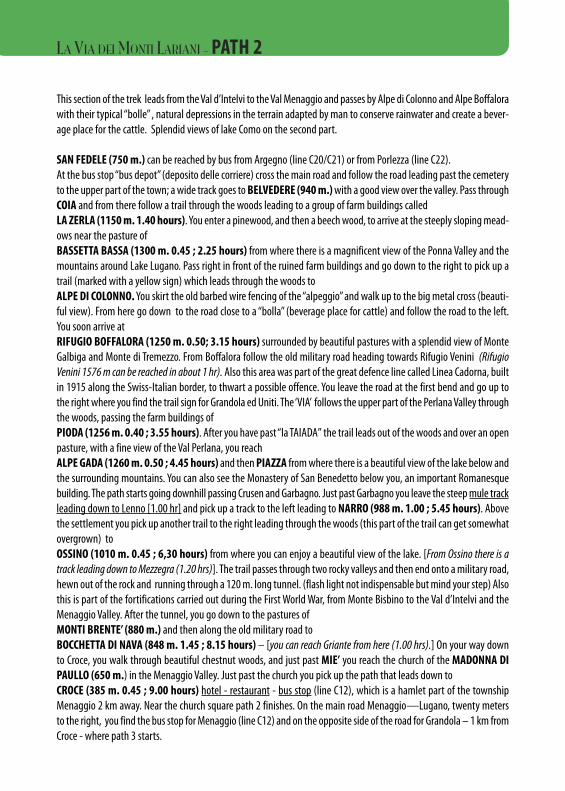
This section of the trek leads from the Val d’Intelvi to the Val Menaggio and passes by Alpe di Colonno and Alpe Boffalorawith their typical “bolle” , natural depressions in the terrain adapted by man to conserve rainwater and create a bever-age place for the cattle. Splendid views of lake Como on the second part.
SAN FEDELE (750 m.) can be reached by bus from Argegno (line C20/C21) or from Porlezza (line C22).At the bus stop “bus depot” (deposito delle corriere) cross the main road and follow the road leading past the cemeteryto the upper part of the town; a wide track goes to BELVEDERE (940 m.)with a good view over the valley. Pass throughCOIA and from there follow a trail through the woods leading to a group of farm buildings calledLA ZERLA (1150 m. 1.40 hours). You enter a pinewood, and then a beech wood, to arrive at the steeply sloping mead-ows near the pasture ofBASSETTA BASSA (1300 m. 0.45 ; 2.25 hours) from where there is a magnificent view of the Ponna Valley and themountains around Lake Lugano. Pass right in front of the ruined farm buildings and go down to the right to pick up atrail (marked with a yellow sign) which leads through the woods to ALPE DI COLONNO.You skirt the old barbed wire fencing of the “alpeggio” and walk up to the big metal cross (beauti-ful view). From here go down to the road close to a “bolla” (beverage place for cattle) and follow the road to the left.You soon arrive at RIFUGIO BOFFALORA (1250 m. 0.50; 3.15 hours) surrounded by beautiful pastures with a splendid view of MonteGalbiga and Monte di Tremezzo. From Boffalora follow the old military road heading towards Rifugio Venini (RifugioVenini 1576 m can be reached in about 1 hr). Also this area was part of the great defence line called Linea Cadorna, builtin 1915 along the Swiss-Italian border, to thwart a possible offence. You leave the road at the first bend and go up tothe right where you find the trail sign for Grandola ed Uniti. The ‘VIA’ follows the upper part of the Perlana Valley throughthe woods, passing the farm buildings of PIODA (1256 m. 0.40 ; 3.55 hours). After you have past “la TAIADA” the trail leads out of the woods and over an openpasture, with a fine view of the Val Perlana, you reachALPE GADA (1260 m. 0.50 ; 4.45 hours) and then PIAZZA from where there is a beautiful view of the lake below andthe surrounding mountains. You can also see the Monastery of San Benedetto below you, an important Romanesquebuilding. The path starts going downhill passing Crusen and Garbagno. Just past Garbagno you leave the steep mule trackleading down to Lenno [1.00 hr] and pick up a track to the left leading to NARRO (988 m. 1.00 ; 5.45 hours). Abovethe settlement you pick up another trail to the right leading through the woods (this part of the trail can get somewhatovergrown) to OSSINO (1010 m. 0.45 ; 6,30 hours) from where you can enjoy a beautiful view of the lake. [From Ossino there is atrack leading down to Mezzegra (1.20 hrs)]. The trail passes through two rocky valleys and then end onto a military road,hewn out of the rock and running through a 120 m. long tunnel. (flash light not indispensable but mind your step) Alsothis is part of the fortifications carried out during the First World War, from Monte Bisbino to the Val d’Intelvi and theMenaggio Valley. After the tunnel, you go down to the pastures ofMONTI BRENTE’ (880 m.) and then along the old military road toBOCCHETTA DI NAVA (848 m. 1.45 ; 8.15 hours) – [you can reach Griante from here (1.00 hrs).] On your way downto Croce, you walk through beautiful chestnut woods, and just past MIE’ you reach the church of the MADONNA DIPAULLO (650 m.) in the Menaggio Valley. Just past the church you pick up the path that leads down toCROCE (385 m. 0.45 ; 9.00 hours) hotel - restaurant - bus stop (line C12), which is a hamlet part of the townshipMenaggio 2 km away. Near the church square path 2 finishes. On the main road Menaggio—Lugano, twenty metersto the right, you find the bus stop for Menaggio (line C12) and on the opposite side of the road for Grandola – 1 km fromCroce - where path 3 starts.
LA VIA DEI MONTI LARIANI - PATH 2
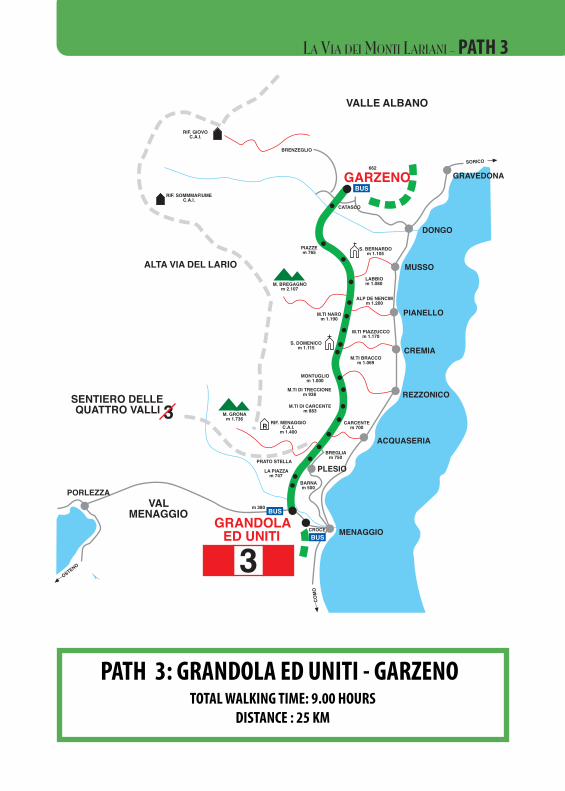
PATH 3: GRANDOLA ED UNITI - GARZENOTOTAL WALKING TIME: 9.00 HOURS
DISTANCE : 25 KM
CERNOBBIO
VALD’INTELVI
VALMENAGGIO
VALLEALBANO
GRANDOLA ED UNITI
SAN FEDELE
GARZENO
COMO
SORICO
VAL D’INTELVI
CERNOBBIO
M. GENEROSOm 1.701
P. DELLA CROCEm 1.492
SASSO GORDONAm 1.410
M. BISBINOm 1.325
M. COLMEGNONEm 1.383
R
ALPE DI CARATEm 1.270
COLMADEL CRINCO
m 1.204
CAP. BRUNOC.A.I
m 1.180
RIF. CRISTÈC.A.I
m 1.129
M.TICAROLZA
m 1.110
PIAN DELLE ALPIm 1.000
RIF. PRABELLOC.A.I.
m 1.200
M.TI MADRONAm 850
M.TI SCARONEm 600
ROVENNAm 450
CÀ BOSSIm 1.150
RIF.DEL BUGONE
m 1.119
RIF. MURELLIC.A.I.
m 1.200
S. BERNARDO
RIF. BINATEC.A.I.
m 1.250
COLMA DI SCHIGNANO
m 202
ALPE D’ORIMENTOm 1.276
CARATE URIO
MOLTRASIO
BRIENNO
ARGEGNO
COMO
SCHIGNANO600
m 779SAN FEDELE
CASASCOm 822
ERBONNE
BELLAGIO
OSTE
NO
MENAGGIO
M. GALBIGAm 1.698
RIF. VENINIm 1.576
M. DI LENNOm 1.589
M. CROCIONEm 1.641
ALPE GADAm 1.260
PIAZZAm 1.200
GARBAGNOm 1.150
PAULLOm 580
BOCCHETTADI NAVAm 848M.TI DI
DI NAVAm 885
M.TI DIBRENTEm 1.000
RIF. BOFFALORAm 1.252
ALPE DI COLONNOm 1.300
BASSETTA BASSAm 1.200
LA ZERLAm 1.172
COLAm 1.000
BELVEDEREm 940
ALPE DI COLAm 1.100
M. COSTONEm 1.441
m 881
m 270
CIMAD. DUARIA
m 1.441
S.BENEDETTOm 800 NARRO
m 950
M.TI OSSINOm 1.010
GALLERIA1915-18m 1.100PIODA
m 1.256R
R
LAINO
OSTENO
PIGRA
OSSUCCIOLENNO
TREMEZZO
GRIANTE
MENAGGIO
m 779
ARGEGNO
m 202
SAN FEDELE
m 676
m 272
m 202
VAL D’INTELVI
m 385
PORLEZZA
VAL MENAGGIO
GRANDOLAED UNITI
CROCE
M. DI TREMEZZOm 1.700
COM
O
DONG
O
LUGANO
M. DI TREMEZZO
S.BENEDETTOm 800
m 1.700
M. COSTONEm 1.441
GRANDOLAED UNITI
CROCE
M. BREGAGNOm 2.107
PIAZZEm 765
M.TI NAROm 1.190
S. DOMENICOm 1.115
MONTUGLIOm 1.000
M.TI DI TRECCIONEm 938
M.TI DI CARCENTEm 883
RIF. MENAGGIOC.A.I.
m 1.400R
M. GRONAm 1.736
PRATO STELLA
LA PIAZZAm 747
BARNAm 500
CARCENTEm 700
BREGLIAm 750
M.TI BRACCOm 1.069
M.TI PIAZZUCCOm 1.170
ALP DE NENCIMm 1.200
LABBIOm 1.080
S. BERNARDOm 1.105
m 380
CATASCO
GRAVEDONA
DONGO
MUSSO
PIANELLO
CREMIA
REZZONICO
ACQUASERIA
MENAGGIOCROCEGRANDOLA
ED UNITI
PORLEZZAVAL
MENAGGIO
GARZENO662
BRENZEGLIO
RIF. GIOVOC.A.I.
RIF. SOMMMAFIUMEC.A.I.
COM
O
OSTENO
SORICO
ALTA VIA DEL LARIO
SENTIERO DELLEQUATTRO VALLI 3
VALLE ALBANO
CHIA
VENN
A
M. DURIAm 2.269
M. DELLA CROCEm 1.887
M.BERLINGHERA
RIF. COMOC.A.I.
m 1.781
MADONNADI LIVIOm 742
BARROm 620
PONTE DIDANGRIm 659
CASNIOLOm 702PONTE
DI VINCINOm 820RIF. VINCINO
m. 1.071
TARÙNm. 960
PUNT DÈBUDANGHEL
m. 981
BADALUCCOm. 940
L’AGNUNm. 920
CARZAN
NESSAm. 840
PIAZZAm 980
IEVIAm 810
CAGNAOm 885
S. ANNAm 818
L’AVOLOm 865
m 662
LIVOm. 675
DOSSODEL LIRO
m. 625
PEGLIOm. 633
S. GIACOMOm. 697
TROBBIOm. 940
PUIIm. 800
TABBIADELLOm. 950
S. BARTOLOMEOm. 1.024
FORDECCIAm. 1.100
SASSOLTm. 950
S. MIROm. 300
m. 202
MONTALTOm. 1.030
R
R
DONGO
CONSIGLIORUMO
GRAVEDONA
DOMASO
COLICO
GERA
ALTA VIA DEL LARIO
VALLE ALBANO
GARZENO
SORICOSORICO
RIF. GIOVO
LECC
O
MENA
GGIO
1
2
3
4
1
23
4
BUS
BUS
BUS
BUS
BUS
R
R
R
BUS
BUS
BUS
BUS
BUS
BUS
S. ANNAm 818
BUS
BUS BUS
BUSBUS
RIF. ALPINOD’ALCOm. 1.000
RIF. ALPINOD’ALCOm. 1.000
RIF. LAGO DARENGOm 1.775 RIF. PIANEZZA
m 1.250
OSSUCCIO
PLESIO
PIAN DELLE ALPIm 1.000
CAGNAOm 885
DONGO
CONSIGLIO RUMO
GRAVEDONA
DOMASO
GERA
LA VIA DEI MONTI LARIANI - PATH 3
This section leads from the Val Menaggio to the Val Albano over the saddle of San Bernardo offering magnificent viewsof Lake Como. Those who want to shorten this long section by 2 hours can take the bus from Menaggio to Breglia (lineC13) and start the walk from there.
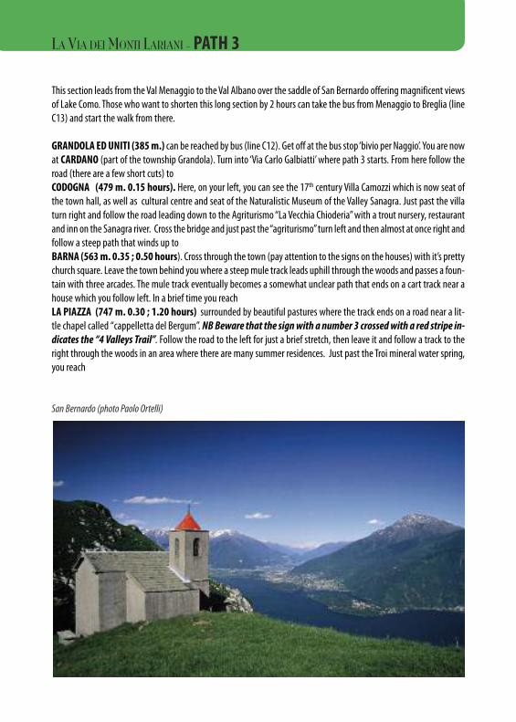
GRANDOLA ED UNITI (385 m.) can be reached by bus (line C12). Get off at the bus stop ‘bivio per Naggio’. You are nowat CARDANO (part of the township Grandola). Turn into ‘Via Carlo Galbiatti’ where path 3 starts. From here follow theroad (there are a few short cuts) toCODOGNA (479 m. 0.15 hours). Here, on your left, you can see the 17th century Villa Camozzi which is now seat ofthe town hall, as well as cultural centre and seat of the Naturalistic Museum of the Valley Sanagra. Just past the villaturn right and follow the road leading down to the Agriturismo “La Vecchia Chioderia” with a trout nursery, restaurantand inn on the Sanagra river. Cross the bridge and just past the “agriturismo” turn left and then almost at once right andfollow a steep path that winds up toBARNA (563 m. 0.35 ; 0.50 hours). Cross through the town (pay attention to the signs on the houses) with it’s prettychurch square. Leave the town behind you where a steep mule track leads uphill through the woods and passes a foun-tain with three arcades. The mule track eventually becomes a somewhat unclear path that ends on a cart track near ahouse which you follow left. In a brief time you reachLA PIAZZA (747 m. 0.30 ; 1.20 hours) surrounded by beautiful pastures where the track ends on a road near a lit-tle chapel called “cappelletta del Bergum”. NB Beware that the sign with a number 3 crossed with a red stripe in-dicates the “4 Valleys Trail”. Follow the road to the left for just a brief stretch, then leave it and follow a track to theright through the woods in an area where there are many summer residences. Just past the Troi mineral water spring,you reach
San Bernardo (photo Paolo Ortelli)
LA VIA DEI MONTI LARIANI -PATH 3
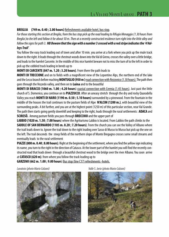
BREGLIA (749 m. 0.40 ; 2.00 hours) Refreshments available hotel, bus stop. For those starting this section at Breglia, from the bus stop pick up the road leading to Rifugio Menaggio (1.30 hours fromBreglia )to the left and follow it for about 50 m. Then at a recently constructed residence turn right into the little alley andfollow the signs for path 3. NBBeware that the sign with a number 3 crossed with a red stripe indicates the ‘4 Val-leys Trail’.You follow the easy track leading out of town and after 10 min. you arrive at a fork where you pick up the mule trackdown to the right. It leads through the chestnut woods down into the Val di Greno, crosses the valley over a little bridge,and leads to the hamlet Carcente. In the middle of this nice hamlet beware not to miss the turn of to the left in order topick up the cobbled track leading in bends up toMONTI DI CARCENTE (847 m. 1.20 ; 3.20 hours). From there the path leads toMONTI DI TRECCIONE and on to fields with a magnificent view of the Lepontine Alps, the northern end of the lakeand the Lecco branch before reaching MONTUGLIO (950 m ) road connection with Rezzonico (1.30 hours). The path thengoes through the Vezzedo valley, and then on to Luina and to the beautiful MONTI DI BRACCO (1060 m. 1.00 ; 4.20 hours) coastal connection with Cremia (1.45 hours). Just past the littlechurch of S. Domenico, you continue on to PIAZZUCCO. After an uneasy stretch through the dry and rocky QuaradellaValley you reach MONTI DI NARO (1190 m. 0.50 ; 5.10 hours) surrounded by a pinewood. From the fountain in themiddle of the houses the trail continues to the pasture fields of Alpe N’ALCIM (1200 m.), with beautiful view of thesurrounding peaks. A bit further, and you are at the highest point (1250 m) of this particular section, near Val Grande.The path then starts going gently downhill and keeping to the right, leads through the rural settlements : ADACA andSCIRESÖ. Among pasture fields you pass through BRECCHIO and the upper part ofLABBIO (1020 m. 1.50 ; 7.00 hours) where the Agriturismo Labbio is located. From Labbio the path climbs to the SADDLE OF SAN BERNARDO (1105 m. 0.20 ; 7.20 hours). From the church you can see the Valley of Albano wherethe trail leads down to. Ignore the trail down to the right leading over Sasso di Musso to Musso but pick up the one onthe left. The trail descends the steep fields of the northern slope of Monte Bregagno crosses some small streams andeventually leads to the rural settlementPIAZZE (800 m. 0.40 ; 8.00 hours). Right at the beginning of the settlement, where you find the yellow sign indicatingits name, you turn to the right in the direction of Catasco. At the lower part of the hamlet you will find the recently con-structed road that leads down through a beautiful chestnut wood to the bridge over the river Albano. You soon arriveat CATASCO (620 m). from where you follow the track leading up toGARZENO (662 m. 1.00 ; 9.00 hours) Bus stop (line C17) refreshments -hotels.
Lavatoio (photo Mario Calzani) Valle S. Jorio (photo Mario Calzani)
LA VIA DEI MONTI LARIANI - PATH 3
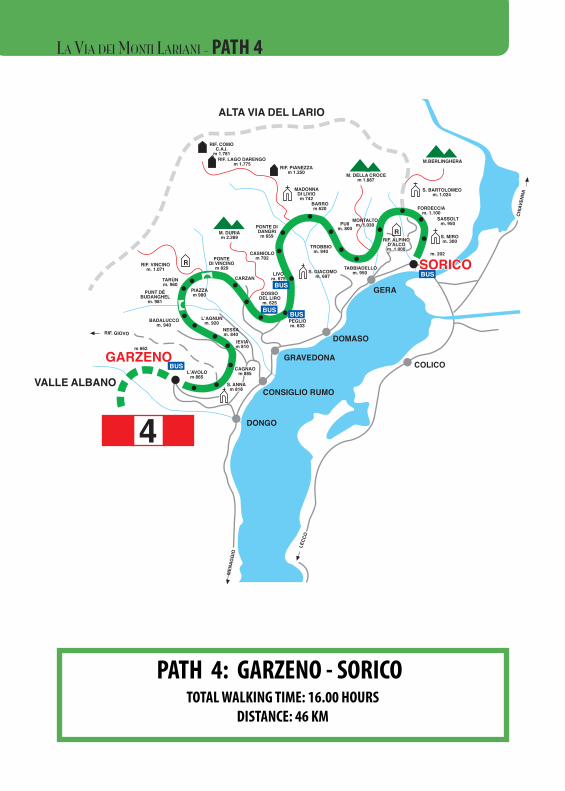
PATH 4: GARZENO - SORICOTOTAL WALKING TIME: 16.00 HOURS
DISTANCE: 46 KM
CERNOBBIO
VALD’INTELVI
VALMENAGGIO
VALLEALBANO
GRANDOLA ED UNITI
SAN FEDELE
GARZENO
COMO
SORICO
VAL D’INTELVI
CERNOBBIO
M. GENEROSOm 1.701
P. DELLA CROCEm 1.492
SASSO GORDONAm 1.410
M. BISBINOm 1.325
M. COLMEGNONEm 1.383
R
ALPE DI CARATEm 1.270
COLMADEL CRINCO
m 1.204
CAP. BRUNOC.A.I
m 1.180
RIF. CRISTÈC.A.I
m 1.129
M.TICAROLZA
m 1.110
PIAN DELLE ALPIm 1.000
RIF. PRABELLOC.A.I.
m 1.200
M.TI MADRONAm 850
M.TI SCARONEm 600
ROVENNAm 450
CÀ BOSSIm 1.150
RIF.DEL BUGONE
m 1.119
RIF. MURELLIC.A.I.
m 1.200
S. BERNARDO
RIF. BINATEC.A.I.
m 1.250
COLMA DI SCHIGNANO
m 202
ALPE D’ORIMENTOm 1.276
CARATE URIO
MOLTRASIO
BRIENNO
ARGEGNO
COMO
SCHIGNANO600
m 779SAN FEDELE
CASASCOm 822
ERBONNE
BELLAGIO
OSTE
NO
MENAGGIO
M. GALBIGAm 1.698
RIF. VENINIm 1.576
M. DI LENNOm 1.589
M. CROCIONEm 1.641
ALPE GADAm 1.260
PIAZZAm 1.200
GARBAGNOm 1.150
PAULLOm 580
BOCCHETTADI NAVAm 848M.TI DI
DI NAVAm 885
M.TI DIBRENTEm 1.000
RIF. BOFFALORAm 1.252
ALPE DI COLONNOm 1.300
BASSETTA BASSAm 1.200
LA ZERLAm 1.172
COLAm 1.000
BELVEDEREm 940
ALPE DI COLAm 1.100
M. COSTONEm 1.441
m 881
m 270
CIMAD. DUARIA
m 1.441
S.BENEDETTOm 800 NARRO
m 950
M.TI OSSINOm 1.010
GALLERIA1915-18m 1.100PIODA
m 1.256R
R
LAINO
OSTENO
PIGRA
OSSUCCIOLENNO
TREMEZZO
GRIANTE
MENAGGIO
m 779
ARGEGNO
m 202
SAN FEDELE
m 676
m 272
m 202
VAL D’INTELVI
m 385
PORLEZZA
VAL MENAGGIO
GRANDOLAED UNITI
CROCE
M. DI TREMEZZOm 1.700
COM
O
DONG
O
LUGANO
M. DI TREMEZZO
S.BENEDETTOm 800
m 1.700
M. COSTONEm 1.441
GRANDOLAED UNITI
CROCE
M. BREGAGNOm 2.107
PIAZZEm 765
M.TI NAROm 1.190
S. DOMENICOm 1.115
MONTUGLIOm 1.000
M.TI DI TRECCIONEm 938
M.TI DI CARCENTEm 883
RIF. MENAGGIOC.A.I.
m 1.400R
M. GRONAm 1.736
PRATO STELLA
LA PIAZZAm 747
BARNAm 500
CARCENTEm 700
BREGLIAm 750
M.TI BRACCOm 1.069
M.TI PIAZZUCCOm 1.170
ALP DE NENCIMm 1.200
LABBIOm 1.080
S. BERNARDOm 1.105
m 380
CATASCO
GRAVEDONA
DONGO
MUSSO
PIANELLO
CREMIA
REZZONICO
ACQUASERIA
MENAGGIOCROCEGRANDOLA
ED UNITI
PORLEZZAVAL
MENAGGIO
GARZENO662
BRENZEGLIO
RIF. GIOVOC.A.I.
RIF. SOMMMAFIUMEC.A.I.
COM
O
OSTENO
SORICO
ALTA VIA DEL LARIO
SENTIERO DELLEQUATTRO VALLI 3
VALLE ALBANO
CHIA
VENN
A
M. DURIAm 2.269
M. DELLA CROCEm 1.887
M.BERLINGHERA
RIF. COMOC.A.I.
m 1.781
MADONNADI LIVIOm 742
BARROm 620
PONTE DIDANGRIm 659
CASNIOLOm 702PONTE
DI VINCINOm 820RIF. VINCINO
m. 1.071
TARÙNm. 960
PUNT DÈBUDANGHEL
m. 981
BADALUCCOm. 940
L’AGNUNm. 920
CARZAN
NESSAm. 840
PIAZZAm 980
IEVIAm 810
CAGNAOCAGNAOm 885m 885
S. S. ANNAANNAm 818m 818
L’AVOLOm 865
m 662
LIVOm. 675
DOSSODEL LIRO
m. 625
PEGLIOm. 633
S. GIACOMOm. 697
TROBBIOm. 940
PUIIm. 800
TABBIADELLOm. 950
S. BARTOLOMEOm. 1.024
FORDECCIAm. 1.100
SASSOLTm. 950
S. MIROm. 300
m. 202
MONTALTOm. 1.030
R
R
DONGO
CONSIGLIORUMO
GRAVEDONA
DOMASO
COLICO
GERA
ALTA VIA DEL LARIO
VALLE ALBANO
GARZENO
SSOORRIICCOOSORICO
RIF. GIOVO
LECC
O
MENA
GGIO
1
2
3
4
1
23
4
BUS
BUS
BUS
BUS
BUS
R
R
R
BUS
BUS
BUS
BUS
BUS
BUS
S. ANNAm 818
BUS
BUS BUS
BUSBUS
RIFRIF. . ALPINOALPINOD’ALCOD’ALCOm. 1.000m. 1.000
RIF. ALPINOD’ALCOm. 1.000
RIF. LAGO DARENGOm 1.775 RIF. PIANEZZA
m 1.250
OSSUCCIO
PLESIO
PIAN DELLE ALPIm 1.000
CAGNAOm 885
DONGO
CONSIGLIO RUMO
GRAVEDONA
DOMASO
GERA
LA VIA DEI MONTI LARIANI - PATH 4
PART ONE: GARZENO – PEGLIOTOTAL WALKING TIME: 8 HOURS - DISTANCE 24 KM
This section, without much ascent, leads away from the lake along the valley of the river Liro and through the valleysof S. Jorio and Dosso and passes by some interesting rural settlements.
GARZENO (662 m.). You can reach Garzeno by bus (line C17) from Dongo. From the bus stop in the church square fol-low a steep path marked with a 3 superimposed by a 4 (path 3 used to pass here) as far as a waterworks cabin. Youcross the field keeping to the right and follow a trail which leads toL’AVOLO (865 m.), a picturesque little hamlet. When you reach the houses (once the roofs were in straw) you end upon a wide track which you follow to the left, and just before reaching a small chapel, you leave the track and pick up thetrail leading up to the right toSANT’ANNA 920m. 0.45 hours) where you find the osteria “Gallo Forcello”. From the “osteria” you follow the roadleading from GARZENO to rifugio GIOVO for a small stretch to the right and at the bend you pick up the mule track lead-ing down to CAGNAO (885 m.) Cross the field and pick up the trail leading into the woods which heads towards themountains dominating the lake out of the Valle Albano. You end up on a road which you follow as far as the bend at thesettlement CRAGNO (850 m) where you pick up the cart track to the left which leaves the mountains facing the lake andleads into the valley. Keep on the even track but leave it at the settlement STABIE’ in order to descend to IEVIA (810 m.).An asphalt road leads from here to the byres of NESSA, where you leave it and turn down to the right. Over a paththrough thick woods you arrive at the clearing ofL’AGNONE (920 m. 1.30 ; 3.00 hours) near a fountain. The ‘Via’ then leads on amongst mountain-ridges and moun-tain streams to the cattle byres of LAMBROSETTO ( 980 m.) and BADALUCCO. From here the trail descends into theS. Jorio valley. Beware of possible landslides in this area! In the distance you can make out the arch of the oldBODANGHEL bridge (985 m. 0.50 ; 3.50 hours) which you cross. The ‘Via’ then passes, half way up the mountainslope, several groups of cattle byres out of stone with an interesting architectonical style. The trail ends on to a carttrack near a small bridge and leads to BOIENA (960 m – picnic area). After a few hundred meters the cart track endsand you continue on a path. Through woods and over fields you enter the heart of the Val del Dosso and meet a pathsigned with yellow paint which leads to Rifugio Vincino. After you passed a bridge you reach PIAZZA (998 m.)whereyou leave the path leading to Rifugio Vincino (20 minutes from the “Via”) and follow the mule track that leads steeplydown to the VINCINO bridge (828 m. 1.30 ; 5.20 hours) over the river Liro. At the other side of the bridge, an easy trail leads up-hill over steep fields, passes some isolated farm buildings, and ends up on a cart track. When you reach the road lead-ing up from DOSSO DEL LIRO you follow it as far as CARZAN, from where a cobbled mule track leads down toDOSSO DEL LIRO (625 m. 1.30 ; 6.50 hours ) where you find the “Ostello Dosso del Liro” and a bus stop (line C18).Follow the road downhill; leave it at the first bend and follow a path to the left leading into the Val Inferno. After pass-ing the stream Ronzone the trail leads half way up the mountain slope pastARECC (702 m. 0.40 ; 7.30 hours) and gets down to the road PEGLIO-LIVO near the little church La Madonna di Piandi Gorghiglio. This section finishes here. To continue turn left to Livo, in order to reach PEGLIO (650 m. 0.30 ; 8.00 hours) – bus stop (line C18) - refreshments – lodging turn right
LA VIA DEI MONTI LARIANI - PATH 4
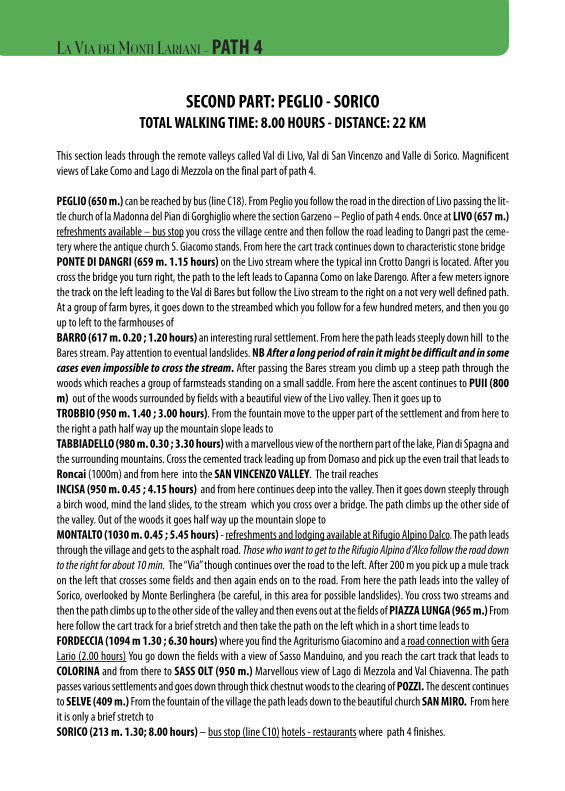
SECOND PART: PEGLIO - SORICOTOTAL WALKING TIME: 8.00 HOURS - DISTANCE: 22 KM
This section leads through the remote valleys called Val di Livo, Val di San Vincenzo and Valle di Sorico. Magnificentviews of Lake Como and Lago di Mezzola on the final part of path 4.
PEGLIO (650 m.) can be reached by bus (line C18). From Peglio you follow the road in the direction of Livo passing the lit-tle church of la Madonna del Pian di Gorghiglio where the section Garzeno – Peglio of path 4 ends. Once at LIVO (657 m.)refreshments available – bus stop you cross the village centre and then follow the road leading to Dangri past the ceme-tery where the antique church S. Giacomo stands. From here the cart track continues down to characteristic stone bridgePONTE DI DANGRI (659 m. 1.15 hours) on the Livo stream where the typical inn Crotto Dangri is located. After youcross the bridge you turn right, the path to the left leads to Capanna Como on lake Darengo. After a few meters ignorethe track on the left leading to the Val di Bares but follow the Livo stream to the right on a not very well defined path.At a group of farm byres, it goes down to the streambed which you follow for a few hundred meters, and then you goup to left to the farmhouses ofBARRO (617 m. 0.20 ; 1.20 hours) an interesting rural settlement. From here the path leads steeply down hill to theBares stream. Pay attention to eventual landslides. NB After a long period of rain it might be difficult and in somecases even impossible to cross the stream. After passing the Bares stream you climb up a steep path through thewoods which reaches a group of farmsteads standing on a small saddle. From here the ascent continues to PUII (800m) out of the woods surrounded by fields with a beautiful view of the Livo valley. Then it goes up toTROBBIO (950 m. 1.40 ; 3.00 hours). From the fountain move to the upper part of the settlement and from here tothe right a path half way up the mountain slope leads to TABBIADELLO (980 m. 0.30 ; 3.30 hours)with a marvellous view of the northern part of the lake, Pian di Spagna andthe surrounding mountains. Cross the cemented track leading up from Domaso and pick up the even trail that leads toRoncai (1000m) and from here into the SAN VINCENZO VALLEY. The trail reachesINCISA (950 m. 0.45 ; 4.15 hours) and from here continues deep into the valley. Then it goes down steeply througha birch wood, mind the land slides, to the stream which you cross over a bridge. The path climbs up the other side ofthe valley. Out of the woods it goes half way up the mountain slope to MONTALTO (1030 m. 0.45 ; 5.45 hours) - refreshments and lodging available at Rifugio Alpino Dalco. The path leadsthrough the village and gets to the asphalt road. Those who want to get to the Rifugio Alpino d’Alco follow the road downto the right for about 10 min. The “Via” though continues over the road to the left. After 200 m you pick up a mule trackon the left that crosses some fields and then again ends on to the road. From here the path leads into the valley ofSorico, overlooked by Monte Berlinghera (be careful, in this area for possible landslides). You cross two streams andthen the path climbs up to the other side of the valley and then evens out at the fields of PIAZZA LUNGA (965 m.) Fromhere follow the cart track for a brief stretch and then take the path on the left which in a short time leads toFORDECCIA (1094 m 1.30 ; 6.30 hours)where you find the Agriturismo Giacomino and a road connection with GeraLario (2.00 hours) You go down the fields with a view of Sasso Manduino, and you reach the cart track that leads toCOLORINA and from there to SASS OLT (950 m.) Marvellous view of Lago di Mezzola and Val Chiavenna. The pathpasses various settlements and goes down through thick chestnut woods to the clearing of POZZI. The descent continuesto SELVE (409 m.) From the fountain of the village the path leads down to the beautiful church SAN MIRO. From hereit is only a brief stretch toSORICO (213 m. 1.30; 8.00 hours) – bus stop (line C10) hotels - restaurants where path 4 finishes.
LA VIA DEI MONTI LARIANI - PATH 4
Always book before starting each section. The indicated opening days are not always respected
PATH 1: CERNOBBIO / SAN FEDELE - 9.30 HOURS
CERNOBBIO
RIFUGIO DEL BUGONE
RIFUGIO DEI MURELLI
AGRIT. ROCCOLO DI SAN BERNARDO
RIFUGIO BINATE
RIFUGIO PRABELLO
CAPANNA GIUSEPPE E BRUNO
ORIMENTO Baita d’Orimento
SAN FEDELE
see hotel list Lago di Como
3.25 hours from Cernobbio - 18 Beds and restaurant serviceopen: the whole year on Saturdays, Sundays- and holidays from 15/6 till 15/9 dailytel.031513808-tel. manager 3334276812 or 3391987409www.rifugiobugone.com
4.10 hours from Cernobbio- 24 beds and restaurant servicetel. 338 8241727Open from April till the end of November on Saturday and Sunday from 15/7 till 15/9 daily
4.20 hours from Cernobbio 10 min. from Colma dei Murelli - 10 beds and restaurant serviceOpen on Saturday and Sunday almost all year round; other days on requestTel 339 3150561
4.40 hours from Cernobbio - 25 beds and restaurant serviceopen the whole year on Saturdays, Sun- and holidays from 1/7 till 15/9 daily Tel. 334 3691854 manager 031 378035
5.30 hours from Cernobbio- 10 beds and restaurant serviceOpen from 15/2 till 1/1 on Saturday, Sun- and holidays on reservationtel. 3407969786 or 031 831905 www.prabello.it [email protected]
7.20 hours from Cernobbio - only restaurant serviceopen from 1/6 till 30/9 every day except Monday, the rest of the year only on Saturday and Sundaytel. 031 83.02.35
8.05 hours from Cernobbio- restaurant service and lodging possibilityopen from 1/5 till 30/9 - rest of the year on Saturday and Sundaytel. 031 83.04.12 or 335 6380242
9.30 hours from Cernobbiosee hotel listing Lago di Como
LA VIA DEI MONTI LARIANI - LODGING AND RESTAURANT LIST
PATH 2: SAN FEDELE D’INTELVI / CROCE - 9.00 hours
SAN FEDELE
RIFUGIO BOFFALORA
RIFUGIO GALBIGA/VENINI
CROCE
GRANDOLA ED UNITI
MENAGGIO
see hotel listing Lago di Como
3.15 hours from San Fedele - 20 Beds and Restaurant serviceopen from Easter till 30/10 Friday, Saturday Sunday and Monday, August dailytel. 0344 56.486 - manager tel. 031 30.77.24
4.15 hours from San Fedele - 20 Beds and restaurant service tel. 0344 56.671
see hotel list Lago di Como - MenaggioAlbergo Adler—tel 0344 32171
see hotel list Lago di Como - Hotel Merloni - Tel. 0344 32.012Closed from Christmas until March
See hotel list Lago di Como
PATH 3: GRANDOLA ED UNITI / GARZENO - 9.00 HOURS
GRANDOLA ED UNITI
BREGLIA
BREGLIA1.30 hours above BregliaRifugio Menaggio
CARCENTE—loc. San MartinoLocanda San Martino
LABBIOAgriturismo Labbio
GARZENO
See hotel list Lago di Comohamlet Mulino Chioderia – Agriturismo LA VECCHIA CHIODERIA Tel. 034430152
2.00 hours from GrandolaAlbergo Breglia - tel. 0344 37.250 - Closed Jan and Feb
3.30 hours from Grandola ed Uniti - 1.30 hours from the „Via“20 beds and restaurant serviceOpen on Saturday and Sunday; from 15.6 to 15.9 dailytel. 0344 37282 -tel. manager 335 5492389
2.50 hours from Grandola ed Uniti - 4 beds and restaurant serviceOpen from Easter till 30/6 Fri. Sat. Sun. From 1/7 till 30/9 every day closed on Monday. From 1.10 till 7.1 Sat and Sun. Closed from 8.1. till the end of MarchTel. 0344 50167
6.40 hours from Grandola ed Uniti - 10 beds and restaurant serviceOpen all year round on reservationtel. 0344 80120 - tel. 333 8906025 www.agriturismolabbio.it
see hotel list Lago di ComoAlbergo de Jean - tel. 0344 88.022
LA VIA DEI MONTI LARIANI - LODGING AND RESTAURANT LIST
PATH 4: GARZENO / PEGLIO - 8.00 HOURS
GARZENO
SANT’ANNAOsteria Il Gallo Forcello
RIFUGIO VINCINO
DOSSO DEL LIROOstello Dosso del Lliro
DOSSO DEL LIROOsteria da Duilia
PEGLIOTrattoria Falco
see hotel list Lago di Como - Albergo de Jean - tel. 0344/88.022
1.00 hour from Garzeno - only restaurant serviceopen on weekends and every day in summer - tel. 0344 88.501
5.00 hours from Garzeno (20 min. away from the trail) - 20 Bedsrefuge without management - reservation and keys available at pizzeria Ponte at Gravedonatel. 0344 85223 / 3337148144 (Pro Loco Consiglio Rumo)
6.50 hours from Garzeno - 25 bedsFor information and reservation tel. 0344 89941
6.50 hours from Garzeno - only restaurant servicetel. 0344 80.330
8.00 hours from Garzeno - 25 beds and restaurant serviceopen all year -tel. 0344 85.444
PATH 4: PEGLIO / SORICO - 8 HOURS
PEGLIOTrattoria Falco
PONTE DANGRICrotto Dangri
MONTALTORifugio Alpino Dalco
FORDECCIAAgriturismo Giacomino
SORICO
8.00 hours from Garzeno - 25 beds and restaurant serviceopen all year -tel. 0344 85.444
1 hour from Peglio - restaurant serviceOpen almost all year roundtel. 3683725705
5.00 hours from Peglio (200 m. away from the trail)20 beds and restaurant serviceopen from Easter till the end of October in the weekends on reservationfrom 15/7 till 15/9 dailytel. 0344 84.572 manager tel. 0344 84387 - [email protected]
6.30 hours from Peglio - beds and restaurant serviceopen from March till October other months on requesttel. 0344 84710 mobile 333 [email protected]
see hotel list Lago di Como
LA VIA DEI MONTI LARIANI - LODGING AND RESTAURANT LIST
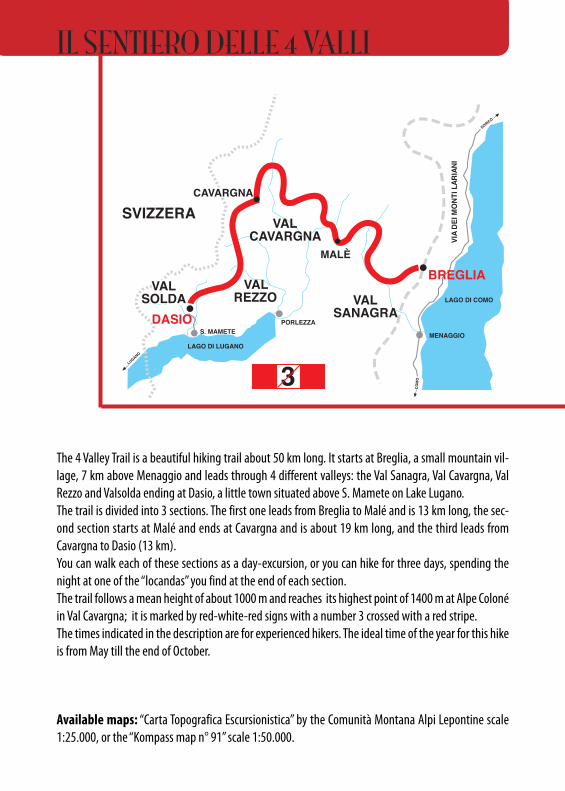
The 4 Valley Trail is a beautiful hiking trail about 50 km long. It starts at Breglia, a small mountain vil-lage, 7 km above Menaggio and leads through 4 different valleys: the Val Sanagra, Val Cavargna, ValRezzo and Valsolda ending at Dasio, a little town situated above S. Mamete on Lake Lugano.The trail is divided into 3 sections. The first one leads from Breglia to Malé and is 13 km long, the sec-ond section starts at Malé and ends at Cavargna and is about 19 km long, and the third leads fromCavargna to Dasio (13 km).You can walk each of these sections as a day-excursion, or you can hike for three days, spending thenight at one of the “locandas” you find at the end of each section. The trail follows a mean height of about 1000 m and reaches its highest point of 1400 m at Alpe Colonéin Val Cavargna; it is marked by red-white-red signs with a number 3 crossed with a red stripe.The times indicated in the description are for experienced hikers. The ideal time of the year for this hikeis from May till the end of October.
Available maps: “Carta Topografica Escursionistica” by the Comunità Montana Alpi Lepontine scale1:25.000, or the “Kompass map n° 91” scale 1:50.000.
•••••
•• • • • • • • • • • • • • • • • • • • • • • • • • • • • • • • • • • • • • • • • • • • • •
m 2.158
C. PIANCHETTE
M. TABOR m 2.157
M. BREGAGNO
CUSINO
m 1.144MALÈ
m 1.190ALPE ERBA
m 1.184ALPE LOGONE
m 1.735
M. GRONA
PONTEm 930 m 750
RIF. MENAGGIOCAI
R
NAGGIO
GRANDOLAm 580
S. FEDELE
PORLEZZA
CARLAZZO
LUGANO
COM
O
VAL SANAGRA
INAIRAL ITNOM IED AIV
GARZENO
SVIZZERA
DASIO
BREGLIA
MENAGGIO
LAGO DI COMO
LAGO DI LUGANO
SORICO
•••••
•• • • • • • • • • • • • • • • • • • • • • • • • • • • • • • • • • • • • • • • • • • • • •
RIF. SOMMAFIUMECAI
m 2.038
CIMA VERTAm 2.245
P. DI GINO m 2.158
C. PIANCHETTE
R
VETTA DEL VALLONE
M. CAMOGHÈ
m 2.118
M. GARZIROLA RIF. GARZIROLA
m 1.200VEGNA
m 1.298GROMIA
m 1.259BEZZACCO
m 1.224RUS DI VORA
m 1.275CARAVA
m 1.118OGGIA
m 925COSTA
SANNAZZAROSAN
BARTOLOMEOCUSINO
m 1.144
m 1.275CASDO DIBURENA
S. FEDELE
PORLEZZA
LUGANO
COM
O
INAIRAL I TNOM I ED AI V
GARZENO
SVIZZERA
LAGO DI COMO
LAGO DI LUGANO
SORICO
DASIO
BREGLIAVAL
CAVARGNA
m 750
BUGGIOLO
m 750
m 1.400COLONÈ
ROCCOLI
m 1.110SEGHEBBIA
m 1.875CIMA DI FIORINA
m 1.037ALPE RICCOLA
m 1.102PASSO STRETTO
m 760RANCO
CAMPINGSAN ROCCO M. BRONZONE
DENTI DELLAVECCHIA
M. BOLGIA m 580
BIV. ALPE VECCHIA
S. FEDELE
OSTENO
PORLEZZA
LUGANO
COM
O
INAIRAL I TNOM I ED AI V
GARZENO
SVIZZERA
DASIO
BREGLIA
LAGO DI COMO
LAGO DI LUGANO
SORICO
VALREZZO
VALSOLDA
MALÈ
LUGANO
COM
O
INAIRAL I TNOM I ED AI V
SVIZZERA
DASIO
BREGLIALAGO DI COMO
LAGO DI LUGANO
SORICO
VALSANAGRA
VALCAVARGNA
VALREZZO
CARCARVVAGNAAGNACAVARGNA
VVALALSOLDASOLDA
VALSOLDA NAGGIO
GRANDOLA
m 1.071
CAVARGNA
3 3
3 3
MENAGGIO
PORLEZZAS. MAMETE
S. MAMETES. MAMETES. MAMETES. MAMETE
MENAGGIOMENAGGIO
VAL SANAGRADOSSOm 850
VARÒO
CAVARGNA
S. MAMETES. MAMETE
MALÈ
BUS
BUS
BUS
R RIF. CROCEDI CAMPO
m 1.741
m 1.280TECCHIO
RRIF. S. LUCIOm 1.542
BUS
R
VETTA DEL VALLONE
M. CAMOGHÈ
m 2.118
M. GARZIROLA RIF. GARZIROLA
m 1.071
CAVARGNARRIF. S. LUCIO
m 1.542BUS
CARLAZZO
GRANDOLAGRANDOLA
CARLAZZO
GRANDOLAGRANDOLABUSBUS
BUSBUS
OSTENO
OSTENO
MALÈ
PLESIO
PLESIO
RIF. MENAGGIOCAI
R
PLESIO
SANNAZZARO
m 1.061PRAMARZIO
IL SENTIERO DELLE 4 VALLI
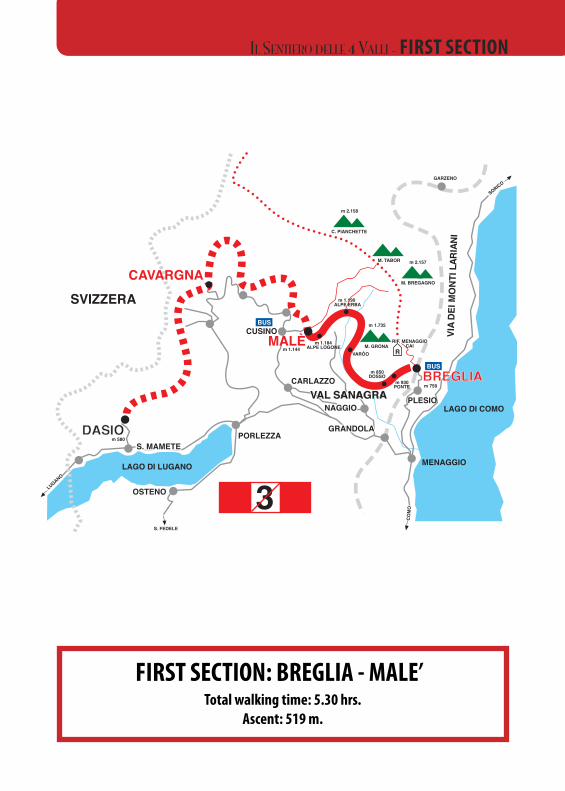
FIRST SECTION: BREGLIA - MALE’Total walking time: 5.30 hrs.
Ascent: 519 m.
•••••
•• • • • • • • • • • • • • • • • • • • • • • • • • • • • • • • • • • • • • • • • • • • • •
m 2.158
C. PIANCHETTE
M. TABOR m 2.157
M. BREGAGNO
CUSINO
m 1.144MALÈ
m 1.190ALPE ERBA
m 1.184ALPE LOGONE
m 1.735
M. GRONA
PONTEm 930 m 750
RIF. MENAGGIOCAI
R
NAGGIONAGGIO
GRANDOLAGRANDOLAm 580
S. FEDELE
PORLEZZA
CARLAZZO
LUGANO
COM
O
VVALAL SANAGRA SANAGRA
INAIRAL ITNOM IED AIV
GARZENO
SVIZZERA
DASIODASIO
BBRREEGGLLIIAA
MENAGGIO
LAGO DI COMO
LAGO DI LUGANO
SORICO
•••••
•• • • • • • • • • • • • • • • • • • • • • • • • • • • • • • • • • • • • • • • • • • • • •
RIF. SOMMAFIUMECAI
m 2.038
CIMA VERTAm 2.245
P. DI GINO m 2.158
C. PIANCHETTE
R
VETTA DEL VALLONE
M. CAMOGHÈ
m 2.118
M. GARZIROLA RIF. GARZIROLA
m 1.200VEGNA
m 1.298GROMIA
m 1.259BEZZACCO
m 1.224RUS DI VORA
m 1.275CARAVA
m 1.118OGGIA
m 925COSTA
SANNAZZAROSAN
BARTOLOMEOCUSINO
m 1.144
m 1.275CASDO DIBURENA
S. FEDELE
PORLEZZA
LUGANO
COM
O
INAIRAL I TNOM I ED AI V
GARZENO
SVIZZERA
LAGO DI COMO
LAGO DI LUGANO
SORICO
DASIO
BREGLIAVAL
CAVARGNA
m 750
BUGGIOLO
m 750
m 1.400COLONÈ
ROCCOLI
m 1.110SEGHEBBIA
m 1.875CIMA DI FIORINA
m 1.037ALPE RICCOLA
m 1.102PASSO STRETTO
m 760RANCO
CAMPINGSAN ROCCO M. BRONZONE
DENTI DELLAVECCHIA
M. BOLGIA m 580
BIV. ALPE VECCHIA
S. FEDELE
OSTENO
PORLEZZA
LUGANO
COM
O
INAIRAL I TNOM I ED AI V
GARZENO
SVIZZERA
DASIO
BREGLIA
LAGO DI COMO
LAGO DI LUGANO
SORICO
VALREZZO
VALSOLDA
MALÈ
LUGANO
COM
O
INAIRAL I TNOM I ED AI V
SVIZZERA
DASIO
BREGLIALAGO DI COMO
LAGO DI LUGANO
SORICO
VALSANAGRA
VALCAVARGNA
VALREZZO
CARVAGNACAVARGNA
VALSOLDA
VALSOLDA NAGGIO
GRANDOLA
m 1.071
CAVARGNA
3 3
3 3
MENAGGIO
PORLEZZAS. MAMETE
S. MAMETES. MAMETES. MAMETES. MAMETE
MENAGGIOMENAGGIO
VAL SANAGRADOSSOm 850
VARÒO
CAVARGNA
SS.. MMAAMMEETTEES. MAMETE
MALÈ
BUS
BUS
BUS
R RIF. CROCEDI CAMPO
m 1.741
m 1.280TECCHIO
RRIF. S. LUCIOm 1.542
BUS
R
VETTA DEL VALLONE
M. CAMOGHÈ
m 2.118
M. GARZIROLA RIF. GARZIROLA
m 1.071
CAVARGNARRIF. S. LUCIO
m 1.542BUS
CARLAZZO
GRANDOLAGRANDOLA
CARLAZZO
GRANDOLAGRANDOLABUSBUS
BUSBUS
OSTENO
OSTENO
MALÈ
PLESIO
PLESIO
RIF. MENAGGIOCAI
R
PLESIO
SANNAZZARO
m 1.061PRAMARZIO
IL SENTIERO DELLE 4 VALLI - FIRST SECTION
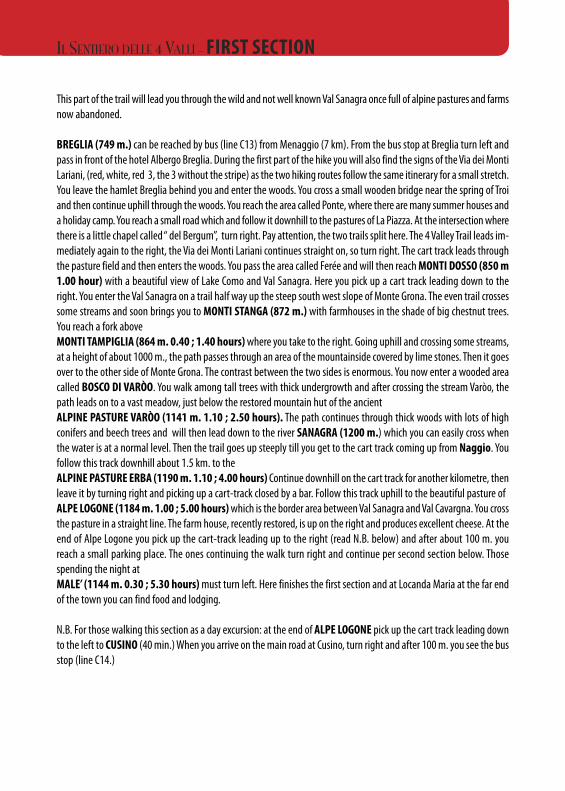
This part of the trail will lead you through the wild and not well known Val Sanagra once full of alpine pastures and farmsnow abandoned.
BREGLIA (749 m.) can be reached by bus (line C13) from Menaggio (7 km). From the bus stop at Breglia turn left andpass in front of the hotel Albergo Breglia. During the first part of the hike you will also find the signs of the Via dei MontiLariani, (red, white, red 3, the 3 without the stripe) as the two hiking routes follow the same itinerary for a small stretch.You leave the hamlet Breglia behind you and enter the woods. You cross a small wooden bridge near the spring of Troiand then continue uphill through the woods. You reach the area called Ponte, where there are many summer houses anda holiday camp. You reach a small road which and follow it downhill to the pastures of La Piazza. At the intersection wherethere is a little chapel called “ del Bergum”, turn right. Pay attention, the two trails split here. The 4 Valley Trail leads im-mediately again to the right, the Via dei Monti Lariani continues straight on, so turn right. The cart track leads throughthe pasture field and then enters the woods. You pass the area called Ferée and will then reach MONTI DOSSO (850 m1.00 hour) with a beautiful view of Lake Como and Val Sanagra. Here you pick up a cart track leading down to theright. You enter the Val Sanagra on a trail half way up the steep south west slope of Monte Grona. The even trail crossessome streams and soon brings you to MONTI STANGA (872 m.) with farmhouses in the shade of big chestnut trees.You reach a fork above MONTI TAMPIGLIA (864 m. 0.40 ; 1.40 hours)where you take to the right. Going uphill and crossing some streams,at a height of about 1000 m., the path passes through an area of the mountainside covered by lime stones. Then it goesover to the other side of Monte Grona. The contrast between the two sides is enormous. You now enter a wooded areacalled BOSCO DI VARÒO. You walk among tall trees with thick undergrowth and after crossing the stream Varòo, thepath leads on to a vast meadow, just below the restored mountain hut of the ancientALPINE PASTURE VARÒO (1141 m. 1.10 ; 2.50 hours). The path continues through thick woods with lots of highconifers and beech trees and will then lead down to the river SANAGRA (1200 m.) which you can easily cross whenthe water is at a normal level. Then the trail goes up steeply till you get to the cart track coming up from Naggio. Youfollow this track downhill about 1.5 km. to the ALPINE PASTURE ERBA (1190 m. 1.10 ; 4.00 hours) Continue downhill on the cart track for another kilometre, thenleave it by turning right and picking up a cart-track closed by a bar. Follow this track uphill to the beautiful pasture ofALPE LOGONE (1184 m. 1.00 ; 5.00 hours)which is the border area between Val Sanagra and Val Cavargna. You crossthe pasture in a straight line. The farm house, recently restored, is up on the right and produces excellent cheese. At theend of Alpe Logone you pick up the cart-track leading up to the right (read N.B. below) and after about 100 m. youreach a small parking place. The ones continuing the walk turn right and continue per second section below. Thosespending the night at MALE’ (1144 m. 0.30 ; 5.30 hours) must turn left. Here finishes the first section and at Locanda Maria at the far endof the town you can find food and lodging.
N.B. For those walking this section as a day excursion: at the end of ALPE LOGONE pick up the cart track leading downto the left to CUSINO (40 min.) When you arrive on the main road at Cusino, turn right and after 100 m. you see the busstop (line C14.)
IL SENTIERO DELLE 4 VALLI - FIRST SECTION
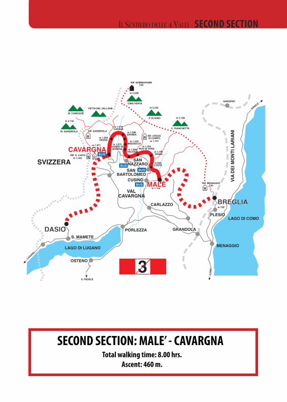
SECOND SECTION: MALE’ - CAVARGNATotal walking time: 8.00 hrs.
Ascent: 460 m.
•••••
•• • • • • • • • • • • • • • • • • • • • • • • • • • • • • • • • • • • • • • • • • • • • •
m 2.158
C. PIANCHETTE
M. TABOR m 2.157
M. BREGAGNO
CUSINO
m 1.144MALÈ
m 1.190ALPE ERBA
m 1.184ALPE LOGONE
m 1.735
M. GRONA
PONTEm 930 m 750
RIF. MENAGGIOCAI
R
NAGGIO
GRANDOLAm 580
S. FEDELE
PORLEZZA
CARLAZZO
LUGANO
COM
O
VAL SANAGRA
INAIRAL ITNOM IED AIV
GARZENO
SVIZZERA
DASIO
BREGLIA
MENAGGIO
LAGO DI COMO
LAGO DI LUGANO
SORICO
•••••
•• • • • • • • • • • • • • • • • • • • • • • • • • • • • • • • • • • • • • • • • • • • • •
RIF. SOMMAFIUMECAI
m 2.038
CIMA VERTAm 2.245
P. DI GINO m 2.158
C. PIANCHETTE
R
VETTA DEL VALLONE
M. CAMOGHÈ
m 2.118
M. GARZIROLA RIF. GARZIROLA
m 1.200VEGNA
m 1.298GROMIA
m 1.259BEZZACCO
m 1.224RUS DI VORA
m 1.275CARAVA
m 1.118OGGIA
m 925COSTA
SANSANNAZZARONAZZAROSAN
BARTOLOMEOCUSINO
m 1.144
m 1.275CASDO DIBURENA
S. FEDELE
PORLEZZA
LUGANO
COM
O
INAIRAL I TNOM I ED AI V
GARZENO
SVIZZERA
LAGO DI COMO
LAGO DI LUGANO
SORICO
DASIODASIO
BREGLIABREGLIAVAL
CAVARGNA
m 750
BUGGIOLO
m 750
m 1.400COLONÈ
ROCCOLI
m 1.110SEGHEBBIA
m 1.875CIMA DI FIORINA
m 1.037ALPE RICCOLA
m 1.102PASSO STRETTO
m 760RANCO
CAMPINGSAN ROCCO M. BRONZONE
DENTI DELLAVECCHIA
M. BOLGIA m 580
BIV. ALPE VECCHIA
S. FEDELE
OSTENO
PORLEZZA
LUGANO
COM
O
INAIRAL I TNOM I ED AI V
GARZENO
SVIZZERA
DASIO
BREGLIA
LAGO DI COMO
LAGO DI LUGANO
SORICO
VALREZZO
VALSOLDA
MALÈ
LUGANO
COM
O
INAIRAL I TNOM I ED AI V
SVIZZERA
DASIO
BREGLIALAGO DI COMO
LAGO DI LUGANO
SORICO
VALSANAGRA
VALCAVARGNA
VALREZZO
CARVAGNACAVARGNA
VALSOLDA
VALSOLDA NAGGIO
GRANDOLA
m 1.071
CAVARGNA
3 3
3 3
MENAGGIO
PORLEZZAS. MAMETE
S. MAMETES. MAMETESS.. MMAAMMEETTEES. MAMETE
MENAGGIOMENAGGIO
VAL SANAGRADOSSOm 850
VARÒO
CAVARGNA
S. MAMETES. MAMETE
MMAALLÈÈ
BUS
BUS
BUS
R RIF. CROCEDI CAMPO
m 1.741
m 1.280TECCHIO
RRIF. S. LUCIOm 1.542
BUS
R
VETTA DEL VALLONE
M. CAMOGHÈ
m 2.118
M. GARZIROLA RIF. GARZIROLA
m 1.071
CAVARGNARRIF. S. LUCIO
m 1.542BUS
CARLAZZO
GRANDOLAGRANDOLAGRANDOLA
CARLAZZO
GRANDOLAGRANDOLABUSBUS
BUSBUS
OSTENO
OSTENO
MALÈ
PLESIO
PLESIO
RIF. MENAGGIOCAI
R
PLESIO
SANNAZZARO
m 1.061PRAMARZIO
IL SENTIERO DELLE 4 VALLI - SECOND SECTION
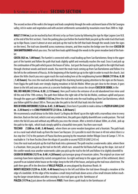
The second section of the walk is the longest and leads completely through the wide catchment basin of the Val Cavargnavalley, rich in water and vegetation and with ancient settlements surrounded by mountains more than 2000 m. high
MALE’ (1144 m.) can be reached by foot (40 min) or by car from Cusino by following the sign for Alpe Logone (see N.B.at the end of the first section). From the parking place just before the hamlet Malè you pick up the wide track that leadsup to Alpe Rozzo. Leave it almost at once and pick up the trail to the left that leads through the woods (note the signson the trees). The trail runs downhill across numerous streams, and then reaches the bridge over the river CUCCIO DISAN BARTOLOMEOwhich you cross. The trail then leads uphill through the woods to the green meadow land of the ham-let COSTA (925 m. 1.00 hour). The hamlet is connected with a road leading up from San Bartolomeo. Keep to the upperpart of the hamlet and follow the path that leads slightly uphill and eventually reaches the road. Cross it and pick upthe continuation of the path which passes the house of Selva. Just past the house pick up the path to the right that leadsthrough chestnut woods and beech woods. You meet the mule track coming up from San Bartolomeo and follow it tothe left to the settlement of Vraccia. At the beginning of the hamlet go up to the right in order to reach the church. Justabove the little church you once again reach the road ending here at the neighbouring hamlet OGGIA (1118 m. 0.30; 1.45 hours). You cross the road and walk through this charming hamlet paying attention to the signs on the houses.From Oggia the path leads over steeply sloping meadows in Val dei Molini. When you get close to the stream, it goesdown to the left and soon you arrive at a concrete footbridge which crosses the stream CUCCIO DI SEBOL in theVAL DEI MOLINI (1134 m. 0.30 ; 2.15 hours). Here you’ll notice the entrance of an old abandoned iron mine usedtill the end of the 19th century. The path then follows the right side of the Val dei Molini, continues uphill and passesthrough the upper part of DARNI (1135 m.) Here the trail ends onto the road leading up from San Bartolomeo, whichyou follow uphill for about 300 m. Then you take the path to the left that leads into the hamlet RUS DI VORA INFERIORE (1224 m. 0.45 ; 3.00 hours). [From here it’s possible to make a detour to PIZZO DI GINO (2245m. 3.30 hours) or to CIMA PIANCHETTE (2158 m. 3.00 hours).]We recommend a small detour to the little church ‘La Regina dei Monti’ up on the right with a marvellous view in everydirection. Back on the trail, which is not very evident here, the path goes slightly downhill over a wide pasture. The trailenters the Val di Lana and without any difficulty you cross the stream. After a stretch of about 300m, at a fork, pick upthe path to the right, which leads steeply uphill to a beautiful view point. You then soon reachTECCHIO (1280 m. 0.40 ; 3.40 hours). where there are some wooden bungalows and a fountain. The path leadson to a rural road which leads up from the town San Nazzaro [it is possible to reach the town in 40 min where there is abus stop line C14] to the pastures of Piazza Vacchera passing by the mountain shelter Rifugio Croce di Campo 1.741 m.reachable in 1 hr from Tecchio [from the rifugio it’s possible to ascend PIZZO DI GINO 2245 m]Cross the rural road and pick up the trail that leads into a pinewood. The path reaches a waterworks cabin, where thereis a fountain. Here you pick up the trail on the left, which runs around the Val Ruina half way up the slope. Just out ofthe conifer woods near another waterworks cabin you pick up the trail to the left and follow it to slightly downhill toCASDO DI BURENA (1275 m. 0.40 ; 4.20 hours) a picturesque group of mountain cabins. The original rye straw roofcoverings have been replaced by rusted corrugated iron. Go right and keep to the upper part of the settlement; directyourself to an isolated white house on the ridge; keep to the left of the house, and pick up the trail near a birch tree. Thepath then goes off in the direction of VALLE PIAZZA, an area plagued by disastrous floods. AtMONTI BEZZACO (1259 m. 0.30 ; 4.40 hours) keep to the left and follow the trail down through a meadow at theedge of a landslide. At the edge of the meadow a small steep trail leads down across a few small streams before reach-ing the larger stream below and after crossing it a nice trail goes up to the farmhouses ofPIAZZA (1179 m.) just above the settlement FOUS. From there a path leads to the farmhouses of
IL SENTIERO DELLE 4 VALLI - SECOND SECTION
MONTI GROMIA (1298 m. 0.25 ; 5.20 hours) Then, at first a not very evident trail, leads along the mountain side,through steeply sloping meadows to the scattered farmhouses ofMONTI CARAVA (1275 m. 0.30 ; 5.50 hours) in the shade of beech and maple trees. Going slightly downhill you de-scend to the river CUCCIO DI CAVARGNA at a height of 1200 m, dominated by the impressive peaks of Mount CimaVerta. A bridge makes it possible to cross the river. The trail then ascends, through a thick state forest plantation. Thengoing downhill and crossing another stream you get on to the mule track leading up from CAVARGNA near the ham-let ofMONTE COLLO (1200 m. 1.10 ; 7.00 hours) inhabited all year round. [From here it’s possible to make a detour to CimaVerta (2078 m. 2.30 hours) and to Vetta del Vallone]. Monte Collo is part of the area called VEGNA DI CAVARGNA. Fol-low the road to MONTI DOSSO but just before the town you pick up the descending track to the left which passes justbelow the hamlet; you skirt the little cemetery of FINSUE and pick up at first a not very well defined path which leadsin bends into the VAL SEGURwhich you cross over an iron bridge. After a stretch through beautiful woods you arriveatCAVARGNA (1071 m 1.00 ; 8.00 hours) near the parish church. Here ends this second section of the 4 Valley Trail. The“locandas” are in the centre of the town and the holiday camp is above the town which you can reach by continuing 500mon the 4-Valley trail. The bus stop is 50 m past the church. At Cavargna we recommend a visit of the ethnographic “Museodella Valle” open on Saturday and Sunday from 14.00 till 17.00, other days on request tel. 0344 63164.
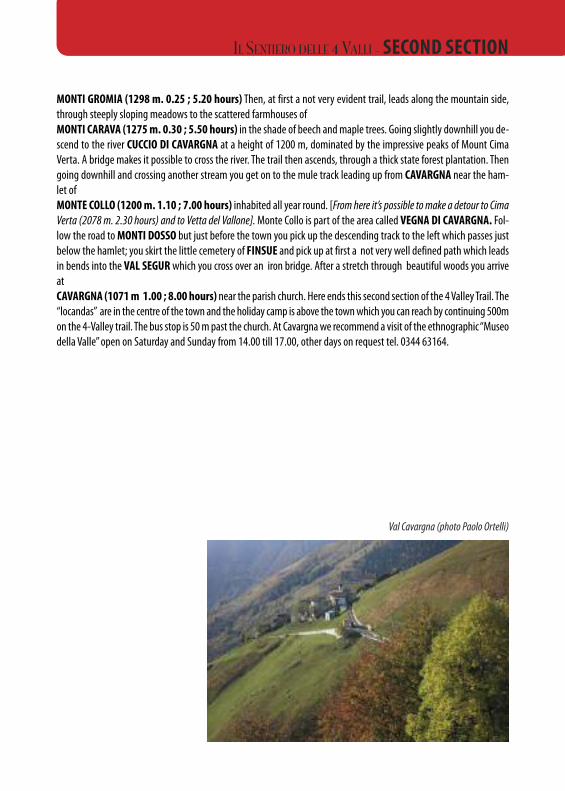
Val Cavargna (photo Paolo Ortelli)
IL SENTIERO DELLE 4 VALLI - SECOND SECTION
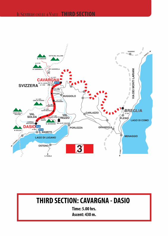
THIRD SECTION: CAVARGNA - DASIOTime: 5.00 hrs.Ascent: 430 m.
•••••
•• • • • • • • • • • • • • • • • • • • • • • • • • • • • • • • • • • • • • • • • • • • • •
m 2.158
C. PIANCHETTE
M. TABOR m 2.157
M. BREGAGNO
CUSINO
m 1.144MALÈ
m 1.190ALPE ERBA
m 1.184ALPE LOGONE
m 1.735
M. GRONA
PONTEm 930 m 750
RIF. MENAGGIOCAI
R
NAGGIO
GRANDOLAm 580
S. FEDELE
PORLEZZA
CARLAZZO
LUGANO
COM
O
VAL SANAGRA
INAIRAL ITNOM IED AIV
GARZENO
SVIZZERA
DASIO
BREGLIA
MENAGGIO
LAGO DI COMO
LAGO DI LUGANO
SORICO
•••••
•• • • • • • • • • • • • • • • • • • • • • • • • • • • • • • • • • • • • • • • • • • • • •
RIF. SOMMAFIUMECAI
m 2.038
CIMA VERTAm 2.245
P. DI GINO m 2.158
C. PIANCHETTE
R
VETTA DEL VALLONE
M. CAMOGHÈ
m 2.118
M. GARZIROLA RIF. GARZIROLA
m 1.200VEGNA
m 1.298GROMIA
m 1.259BEZZACCO
m 1.224RUS DI VORA
m 1.275CARAVA
m 1.118OGGIA
m 925COSTA
SANNAZZAROSAN
BARTOLOMEOCUSINO
m 1.144
m 1.275CASDO DIBURENA
S. FEDELE
PORLEZZA
LUGANO
COM
O
INAIRAL I TNOM I ED AI V
GARZENO
SVIZZERA
LAGO DI COMO
LAGO DI LUGANO
SORICO
DASIO
BREGLIAVAL
CAVARGNA
m 750
BUGGIOLO
m 750
m 1.400COLONÈ
ROCCOLI
m 1.110SEGHEBBIA
m 1.875CIMA DI FIORINA
m 1.037ALPE RICCOLA
m 1.102PASSO STRETTO
m 760RANCO
CAMPINGSAN ROCCO M. BRONZONE
DENTI DELLAVECCHIA
M. BOLGIA m 580
BIV. ALPE VECCHIA
S. FEDELE
OSTENO
PORLEZZA
LUGANO
COM
O
INAIRAL I TNOM I ED AI V
GARZENO
SVIZZERA
DASIO
BREGLIABREGLIA
LAGO DI COMO
LAGO DI LUGANO
SORICO
VALREZZO
VALSOLDA
MALÈ
LUGANO
COM
O
INAIRAL I TNOM I ED AI V
SVIZZERA
DASIO
BREGLIALAGO DI COMO
LAGO DI LUGANO
SORICO
VALSANAGRA
VALCAVARGNA
VALREZZO
CARVAGNACAVARGNA
VALSOLDA
VALSOLDA NAGGIO
GRANDOLA
m 1.071
CAVARGNA
3 3
3 3
MENAGGIO
PORLEZZAS. MAMETE
SS.. MMAAMMEETTEES. MAMETES. MAMETES. MAMETE
MENAGGIOMENAGGIO
VAL SANAGRADOSSOm 850
VARÒO
CAVARGNA
S. MAMETES. MAMETE
MALÈ
BUS
BUS
BUS
R RIF. CROCEDI CAMPO
m 1.741
m 1.280TECCHIO
RRIF. S. LUCIOm 1.542
BUS
R
VETTA DEL VALLONE
M. CAMOGHÈ
m 2.118
M. GARZIROLA RIF. GARZIROLA
m 1.071
CAVARGNARRIF. S. LUCIO
m 1.542BUS
CARLAZZO
GRANDOLAGRANDOLA
CARLAZZO
GRANDOLAGRANDOLAGRANDOLABUSBUS
BUSBUS
OSTENO
OSTENO
MALÈ
PLESIO
PLESIO
RIF. MENAGGIOCAI
R
PLESIO
SANNAZZARO
m 1.061PRAMARZIO
IL SENTIERO DELLE 4 VALLI - THIRD SECTION
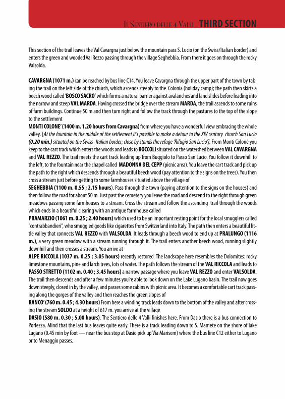
This section of the trail leaves the Val Cavargna just below the mountain pass S. Lucio (on the Swiss/Italian border) andenters the green and wooded Val Rezzo passing through the village Seghebbia. From there it goes on through the rockyValsolda.
CAVARGNA (1071 m.) can be reached by bus line C14. You leave Cavargna through the upper part of the town by tak-ing the trail on the left side of the church, which ascends steeply to the Colonia (holiday camp); the path then skirts abeech wood called ‘BOSCO SACRO‘ which forms a natural barrier against avalanches and land slides before leading intothe narrow and steep VAL MARDA. Having crossed the bridge over the stream MARDA, the trail ascends to some ruinsof farm buildings. Continue 50 m and then turn right and follow the track through the pastures to the top of the slopeto the settlementMONTI COLONE’ (1400 m. 1.20 hours from Cavargna) from where you have a wonderful view embracing the wholevalley. [At the fountain in the middle of the settlement it’s possible to make a detour to the XIV century church San Lucio(0.20 min.) situated on the Swiss- Italian border; close by stands the refuge ‘Rifugio San Lucio’]. From Monti Coloné youkeep to the cart track which enters the woods and leads to ROCCOLI situated on the watershed between VAL CAVARGNAand VAL REZZO. The trail meets the cart track leading up from Buggiolo to Passo San Lucio. You follow it downhill tothe left, to the fountain near the chapel called MADONNA DEL CEPP (picnic area). You leave the cart track and pick upthe path to the right which descends through a beautiful beech wood (pay attention to the signs on the trees). You thencross a stream just before getting to some farmhouses situated above the village ofSEGHEBBIA (1100 m. 0.55 ; 2.15 hours). Pass through the town (paying attention to the signs on the houses) andthen follow the road for about 50 m. Just past the cemetery you leave the road and descend to the right through greenmeadows passing some farmhouses to a stream. Cross the stream and follow the ascending trail through the woodswhich ends in a beautiful clearing with an antique farmhouse calledPRAMARZIO (1061 m. 0.25 ; 2.40 hours)which used to be an important resting point for the local smugglers called“contrabbandieri”, who smuggled goods like cigarettes from Switzerland into Italy. The path then enters a beautiful lit-tle valley that connects VAL REZZO with VALSOLDA. It leads through a beech wood to end up at PRALUNGO (1116m.), a very green meadow with a stream running through it. The trail enters another beech wood, running slightlydownhill and then crosses a stream. You arrive atALPE RICCOLA (1037 m. 0.25 ; 3.05 hours) recently restored. The landscape here resembles the Dolomites: rockylimestone mountains, pine and larch trees, lots of water. The path follows the stream of the VAL RICCOLA and leads toPASSO STRETTO (1102 m. 0.40 ; 3.45 hours) a narrow passage where you leave VAL REZZO and enter VALSOLDA.The trail then descends and after a few minutes you’re able to look down on the Lake Lugano basin. The trail now goesdown steeply, closed in by the valley, and passes some cabins with picnic area. It becomes a comfortable cart track pass-ing along the gorges of the valley and then reaches the green slopes ofRANCO’ (760 m. 0.45 ; 4.30 hours) From here a winding track leads down to the bottom of the valley and after cross-ing the stream SOLDO at a height of 617 m. you arrive at the village DASIO (580 m. 0.30 ; 5.00 hours). The Sentiero delle 4 Valli finishes here. From Dasio there is a bus connection toPorlezza. Mind that the last bus leaves quite early. There is a track leading down to S. Mamete on the shore of lakeLugano (0.45 min by foot — near the bus stop at Dasio pick up Via Marisem) where the bus line C12 either to Luganoor to Menaggio passes.
IL SENTIERO DELLE 4 VALLI - THIRD SECTION
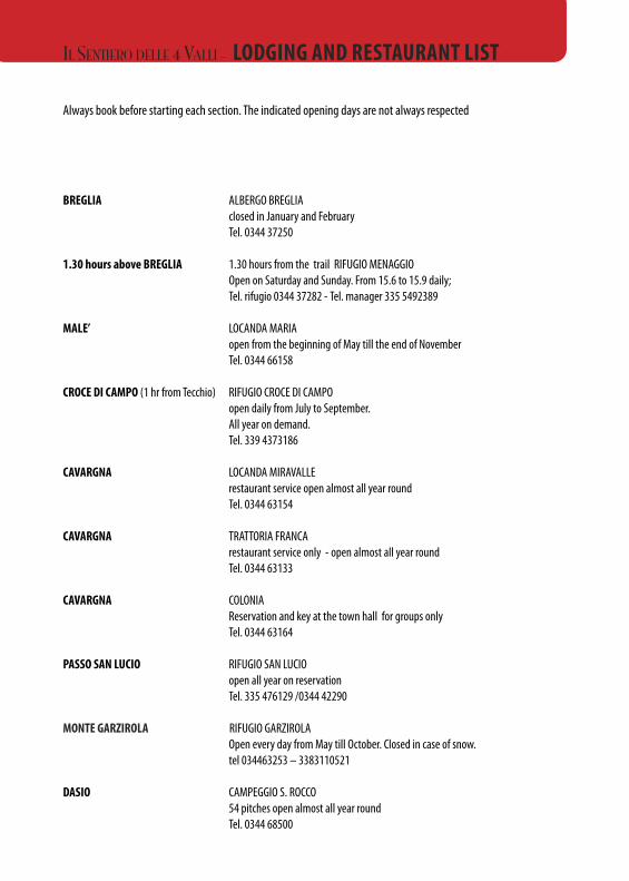
Always book before starting each section. The indicated opening days are not always respected
BREGLIA ALBERGO BREGLIAclosed in January and FebruaryTel. 0344 37250
1.30 hours above BREGLIA 1.30 hours from the trail RIFUGIO MENAGGIOOpen on Saturday and Sunday. From 15.6 to 15.9 daily; Tel. rifugio 0344 37282 - Tel. manager 335 5492389
MALE’ LOCANDA MARIAopen from the beginning of May till the end of November Tel. 0344 66158
CROCE DI CAMPO (1 hr from Tecchio) RIFUGIO CROCE DI CAMPOopen daily from July to September.All year on demand.Tel. 339 4373186
CAVARGNA LOCANDA MIRAVALLErestaurant service open almost all year roundTel. 0344 63154
CAVARGNA TRATTORIA FRANCArestaurant service only - open almost all year round Tel. 0344 63133
CAVARGNA COLONIAReservation and key at the town hall for groups only Tel. 0344 63164
PASSO SAN LUCIO RIFUGIO SAN LUCIOopen all year on reservationTel. 335 476129 /0344 42290
MONTE GARZIROLA RIFUGIO GARZIROLA Open every day from May till October. Closed in case of snow.tel 034463253 – 3383110521
DASIO CAMPEGGIO S. ROCCO54 pitches open almost all year roundTel. 0344 68500
IL SENTIERO DELLE 4 VALLI - LODGING AND RESTAURANT LIST
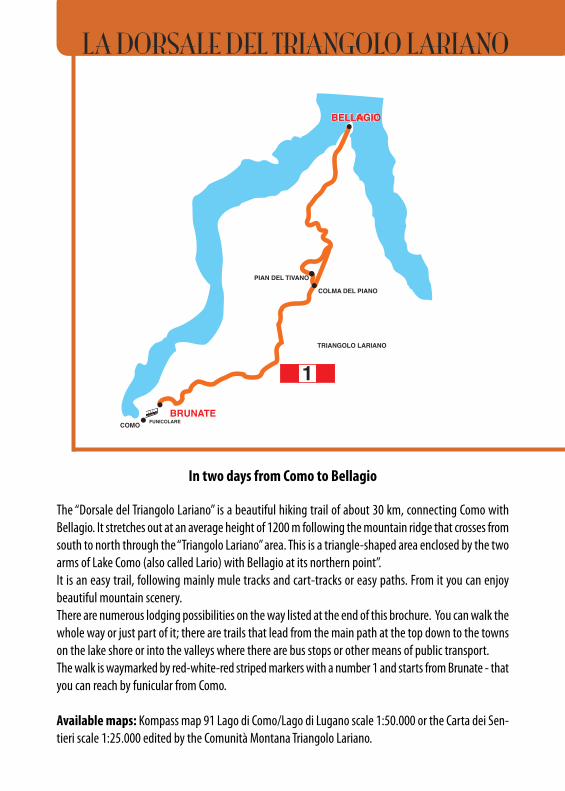
In two days from Como to Bellagio
The “Dorsale del Triangolo Lariano” is a beautiful hiking trail of about 30 km, connecting Como withBellagio. It stretches out at an average height of 1200 m following the mountain ridge that crosses fromsouth to north through the “Triangolo Lariano” area. This is a triangle-shaped area enclosed by the twoarms of Lake Como (also called Lario) with Bellagio at its northern point”.It is an easy trail, following mainly mule tracks and cart-tracks or easy paths. From it you can enjoybeautiful mountain scenery. There are numerous lodging possibilities on the way listed at the end of this brochure. You can walk thewhole way or just part of it; there are trails that lead from the main path at the top down to the townson the lake shore or into the valleys where there are bus stops or other means of public transport. The walk is waymarked by red-white-red striped markers with a number 1 and starts from Brunate - thatyou can reach by funicular from Como.
Available maps: Kompass map 91 Lago di Como/Lago di Lugano scale 1:50.000 or the Carta dei Sen-tieri scale 1:25.000 edited by the Comunità Montana Triangolo Lariano.
COMO
BRUNATE
PIAN DELTIVANO
BELLAGIO
P. TRE TERMINIm 1.140
M. BOLETTOm 1.236
RIF. CAOm 980 M. UCCELLERA
m 1.027S. MAURIZIO
m 906
m 715
BOLETTOFABRIZIOm 1.100
BOCCHETTADI LEMNAm 1.167
M. BOLETTONEm 1.317
M. PALANZONEm 1.436
BOCCHETTADI MOLINA
m 1.116
RIF. BOLETTONEm 1.310
RIF. RIELLAm 1.275
BOCCHETTADI CAGLIOM. FAELLO
m 1.243
M. CROCEm 1.351
M. PIANCHETTEm 1.243
COLMA DEL PIANOm 1.124
m 973
R
CASLINO D’ERBA
ALBAVILLA
TORNOMOLINA
FAGGETO LARIOLEMNAPALANZO
POGNANA LARIO
NESSO
LEZZENO
CAPANNAMARA
ALPE DEL VICERÈ
CAPANNASAN PIETRO
m 1.116
BAITA CARLAm 997
BAITA BONDELLAm 1.075
BOCCHETTADI PALANZO
m 1.210
R
CIPPO MARELLIm 1.293
COLMA DI CAGLIOm 1.129
LECCO
COMO
BRUNATE
PIANDEL TIVANO
BELLAGIO
m 715
m 973
A. DEL CIUCHETTONm 1.033
A. DI TORNOm. 1131
A. DI TERRA BIOTTAm 1.436
M. NUVOLONEm 1.094
ROVENZAm 937
PAUMm 957
A. DI BORGOm 1.180
BROGNOm 582
PERLOm 362
M. SAN PRIMOm 582
BEGOLAm 560
TORNOMOLINA
LEMNAPALANZO
POGNANA LARIO
NESSO
LEZZENO
LECCO
GUGGIATEm 230
A. DI SPESSOLAm. 1237
BORGO S.PRIMOm 1.107
MAGREGLIO
COMOBRUNATE
PIAN DEL TIVANO
BBEELLLLAAGGIIOOBELLAGIO
TRIANGOLO LARIANO
TRIANGOLO LARIANOTRIANGOLO LARIANO
1
COLMA DEL PIANO
1
GUGGIATEm 230
R
R
FAGGETO LARIO
CASLINO D’ERBA
ALBAVILLA
ALPE DEL VICERÈ
1
COLMA DEL PIANOm 1.124
MADONNADEL GHISALLO
MADONNADEL GHISALLO
CIVENNA
R. MARTINAm 1233
R
BUSFUNICOLARE
BUS
BUS
BUS
FUNICOLARE
FUNICOLARE
COLMA DEL BOSCOm. 1233PIAN DEL
TIVANOPIAN
DEL TIVANO
GUGGIATEm 230
CIVENNA
LA DORSALE DEL TRIANGOLO LARIANO
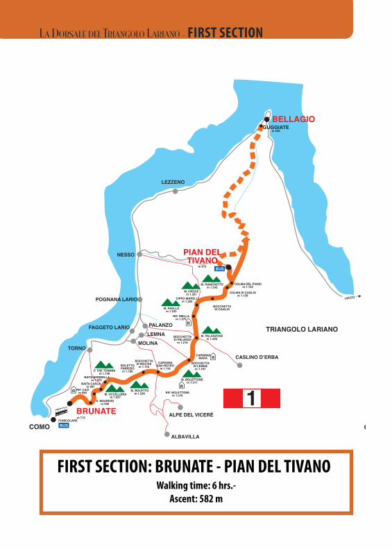
FIRST SECTION: BRUNATE - PIAN DEL TIVANOWalking time: 6 hrs.-Ascent: 582 m
COMO
BRUNATE
PPIIAANN DDEELLTTIIVVAANNOO
BELLAGIO
P. TRE TERMINIm 1.140
M. BOLETTOm 1.236
RIF. CAOm 980 M. UCCELLERA
m 1.027S. MAURIZIO
m 906
m 715
BOLETTOFABRIZIOm 1.100
BOCCHETTADI LEMNAm 1.167
M. BOLETTONEm 1.317
M. PALANZONEm 1.436
BOCCHETTADI MOLINA
m 1.116
RIF. BOLETTONEm 1.310
RIF. RIELLAm 1.275
BOCCHETTADI CAGLIOM. FAELLO
m 1.243
M. CROCEm 1.351
M. PIANCHETTEm 1.243
COLMA DEL PIANOm 1.124
m 973
R
CASLINO D’ERBA
ALBAVILLA
TORNOMOLINA
FAGGETO LARIOLEMNAPALANZO
POGNANA LARIO
NESSO
LEZZENO
CAPANNAMARA
ALPE DEL VICERÈ
CAPANNASAN PIETRO
m 1.116
BAITA CARLAm 997
BAITA BONDELLAm 1.075
BOCCHETTADI PALANZO
m 1.210
R
CIPPO MARELLIm 1.293
COLMA DI CAGLIOm 1.129
LECCO
COMO
BRUNATE
PIANDEL TIVANO
BELLAGIO
m 715
m 973
A. DEL CIUCHETTONm 1.033
A. DI TORNOm. 1131
A. DI TERRA BIOTTAm 1.436
M. NUVOLONEm 1.094
ROVENZAm 937
PAUMm 957
A. DI BORGOm 1.180
BROGNOm 582
PERLOm 362
M. SAN PRIMOm 582
BEGOLAm 560
TORNOMOLINA
LEMNAPALANZO
POGNANA LARIO
NESSO
LEZZENO
LECCO
GUGGIATEm 230
A. DI SPESSOLAm. 1237
BORGO S.PRIMOm 1.107
MAGREGLIO
COMOBRUNATE
PIAN DEL TIVANO
BELLAGIOBELLAGIO
TRIANGOLO LARIANO
TRIANGOLO LARIANOTRIANGOLO LARIANO
1
COLMA DEL PIANO
1
GUGGIATEm 230
R
R
FAGGETO LARIO
CASLINO D’ERBA
ALBAVILLA
ALPE DEL VICERÈ
1
COLMA DEL PIANOm 1.124
MADONNADEL GHISALLO
MADONNADEL GHISALLO
CIVENNA
R. MARTINAm 1233
R
BUSFUNICOLARE
BUS
BUS
BUS
FUNICOLARE
FUNICOLARE
COLMA DEL BOSCOm. 1233PIAN DEL
TIVANOPIAN
DEL TIVANO
GUGGIATEm 230
CIVENNA
LA DORSALE DEL TRIANGOLO LARIANO - FIRST SECTION
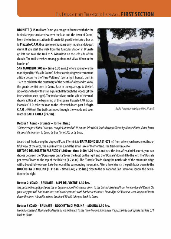
BRUNATE (715 m) From Como you can go to Brunate with the thefunicular (spectacular view over the lake and the town of Como)From the funicular station in Brunate it’s possible to take a bus asto Piazzale C.A.O. (bus service on Sundays only; in July and Augustdaily). If you start the walk from the funicular station in Brunatego left and take the trail to S. Maurizio on the left side of thechurch. The trail stretches among gardens and villas. When in thehamlet ofSAN MAURIZIO (906 m - time 0.30 min.)where you ignore theroad signed for “Via alle Colme”. Before continuing we recommenda little detour to the “Faro Voltiano” (Volta light house), built in1927 to celebrate the centenary of the death of Alessandro Volta,the great scientist born in Como. Back in the square, go to the leftside of it and follow the trail signs uphill through the woods (at theintersections keep right). The track ends up on the side of the smallchurch S. Rita at the beginning of the square Piazzale CAO. AcrossPiazzale C.A.O. take the road to the left which leads past RifugioC.A.O . (980 m). The trail continues through the woods and soonreaches BAITA CARLA (997 m).
Detour 1: Como - Brunate – Torno (3hrs.)300 meters past Baita Carla you can pick up trail n° 15 on the left which leads down to Torno by Monte Piatto. From Tornoit’s possible to return to Como by bus (line C 30) or by boat.
A cart-track leads along the slopes of Pizzo 3 Termini, to BAITA BONDELLA (1.075 m) from where you have a most beau-tiful view of the Alps, the Alpi Marittime, and the small lake of Montorfano. The trail continues to RISTORO DEL BOLETTO FABRIZIO (1.100 m - time 0.50; 1.20 hrs.) Just past this inn, after a brief ascent, you canchoose between the “Dorsale per Cresta” (over the tops) on the right and the “Dorsale” downhill to the left. The “Dorsaleper cresta” leads to the top of the Boletto (1.236 m). The “Dorsale” leads along the north side of the mountain ridgewith a beautiful view over Lake Como and the surrounding mountains. After a level stretch the path leads down to the BOCCHETTA DI MOLINA (1.116 m. - time 0.40; 2.15 hrs.) close to the ex Capanna San Pietro You ignore the devia-tion to the right.
Detour 2: COMO – BRUNATE – ALPE DEL VICERE’ 3.30 hrs.The path to the right just past the ex Capanna San Pietro leads down to the Baita Patrizi and from here to Ape del Vicerè. Onyour way you will find some inns and picnic grounds with barbecue facilities. From Alpe del Vicerè a 5 km long road leadsdown the town Albavilla, where bus line C40 will take you back to Como
Detour 3 COMO – BRUNATE – BOCCHETTA DI MOLINA – MOLINA 3.30 hrs.From Bocchetta di Molina a trail leads down to the left to the town Molina. From here it’s possible to pick up the bus line C31back to Como.
Bolla Palanzone (photo Gino Siclari)
LA DORSALE DEL TRIANGOLO LARIANO - FIRST SECTION
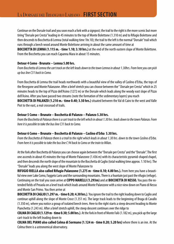
Continue on the Dorsale trail and you soon reach a fork with a signpost; the trail to the right is the more scenic but moretiring “Dorsale per Cresta” leading in 45 minutes to the top of Monte Bolettone (1.310 m) and to Rifugio Bolettone andthen descends to Bocchetta di Lemna (total walking time 1hr.10); the trail to the left is the normal “Dorsale” trail whichruns through a beech wood around Monte Bolettone arriving in about the same amount of time atBOCCHETTA DI LEMNA (1.115 m. - time 1.10; 3.10 hrs.) at the end of the north eastern slope of Monte Bolettone.From the Bocchetta you can reach Capanna Mara in about 15 minutes.
Detour 4 Como - Brunate – Lemna 5.00 hrs.From Bocchetta di Lemna the cart track on the left leads down to the town Lemna in about 1.30hrs. From here you can pickup bus line C31 back to Como.
From Bocchetta di Lemna the trail heads northwards with a beautiful view of the valley of Caslino d’Erba, the tops ofthe Resegone and Monte Palanzone. After a brief stretch you can choose between the “ Dorsale per Cresta” which in 25minutes heads to the top of Pizzo dell’Asino (1272 m) or the Dorsale which leads along the woody east slope of Pizzodell’Asino. After you have passed two streams (note the formation of the sedimentary layers) you reachBOCCHETTA DI PALANZO (1.210 m.- time 0.40; 3.50 hrs.) situated between the Val di Cairo to the west and VallePiot to the east, a real crossroad of trails.
Detour 5 Como – Brunate – Bocchetta di Palanzo – Palanzo 5.30 hrs.From the Bocchetta di Palanzo there is a cart track to the left which in about 1.30 hrs. leads down to the town Palanzo. Fromhere it is possible to take the bus line C31 back to Como.
Detour 6 Como – Brunate – Bocchetta di Palanzo – Caslino d’Erba 5.30 hrs.From the Bocchetta di Palanzo there is a trail to the right which leads in about 1.30 hrs. down to the town Caslino d’Erba.From here it is possible to take the bus line C 94 back to Como or the train to Milan.
At the fork after Bocchetta di Palanzo you can choose again between the “Dorsale per Cresta” and the “Dorsale”. The firstone ascends in about 45 minutes the top of Monte Palanzone (1.436 m) with its characteristic pyramid-shaped chapel,and then descends the north slope of the mountain to the Bocchetta di Caglio (total walking time approx. 1.10 hrs). The“Dorsale” leads you along the west slope of Monte Palanzone toRIFUGIO RIELLA also called Rifugio Palanzone (1.275 m - time 0.10; 4.00 hrs.). From here you have a beauti-ful view over Lake Como, Faggeto Lario and the surrounding mountains. There is a fountain just past the rifugio (refuge).Continuing on the trail you soon arrive at CIPPO MARELLI (1.293m) and at BOCCHETTA DI NESSO. You pass the ex-tended fields of Preaola on a level track which leads around Monte Palanzone with a nice view down on Piano di Nessoand Monte San Primo. You then arrive atBOCCHETTA DI CAGLIO (1.297 m. - time 0.20; 4.30 hrs.). You ignore the trail to the right leading down to Caglio andcontinue uphill along the slope of Monte Croce (1.351 m). The large track leads to the beginning of Braga di Cavallo(1.350 m), where you notice a group of isolated beech trees. Here to the right starts a steep descent heading to MontePianchetta (1.243 m). After a brief stretch uphill, the steep descent continues over the ridge toCOLMA DI CAGLIO (1.129 m - time 0.30; 5.00 hrs.). At the fork in front of Monte Falò (1.182 m), you pick up the largecart-track to the left leading down toCOLMA DEL PIANO also called Colma di Sormano (1.124 m - time 0.20; 5.20 hrs)where there is an inn. At theColma there is a astronomical observatory.
LA DORSALE DEL TRIANGOLO LARIANO - FIRST SECTION
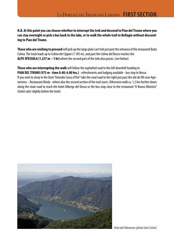
N.B. At this point you can choose whether to interrupt the trek and descend to Pian del Tivano where youcan stay overnight or pick a bus back to the lake, or to walk the whole trail to Bellagio without descend-ing to Pian del Tivano.
Those who are wishing to proceedwill pick up the large plain cart trek just past the entrance of the restaurant BaitaColma. The track leads up to Colma dei Cippiei (1.185 m), and past the Colma del Bosco reaches the ALPE SPESSOLA (1.237 m – 1 hr)where the second part of the trek also passes. (see below)
Those who are interrupting the walk will follow the asphalted road to the left downhill heading to PIAN DEL TIVANO (973 m - time 0.40; 6.00 hrs.) - refreshments and lodging available - bus stop to Nesso. If you wish to sleep in the farm “Azienda Conca d’Oro” take the rural road to the right just past the old ski lift near Agri-turismo – Restaurant Binda - where also the second section of the trail starts. Otherwise walk ca. 1,5 km further downalong the main road to reach the hotel Albergo del Dosso or the bus stop close to the restaurant “Il Nuovo Ministro”(ticket sale) slightly before the hotel.
Vista dal Palanzone (photo Gino Siclari)
LA DORSALE DEL TRIANGOLO LARIANO - FIRST SECTION
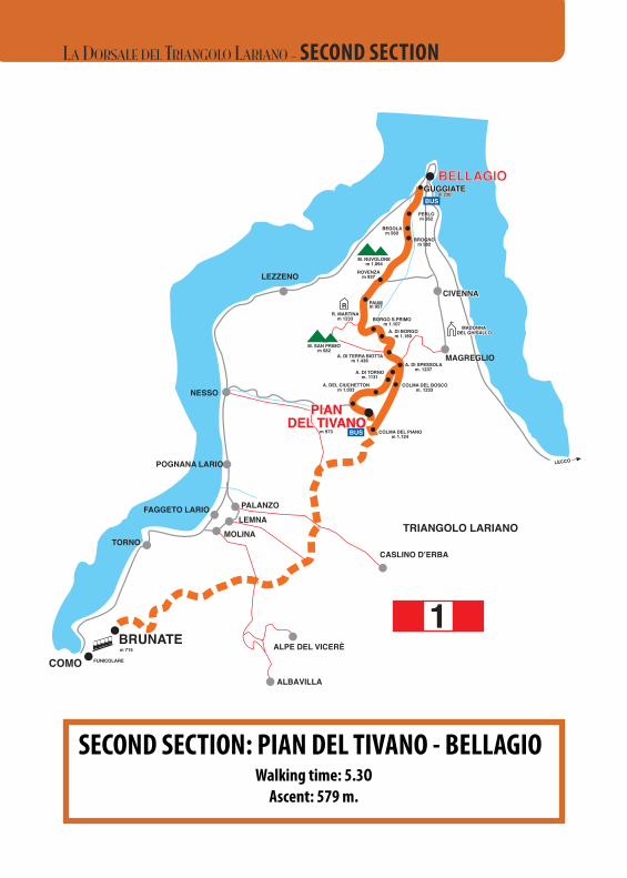
SECOND SECTION: PIAN DEL TIVANO - BELLAGIOWalking time: 5.3O Ascent: 579 m.
COMO
BRUNATE
PIAN DELTIVANO
BELLAGIO
P. TRE TERMINIm 1.140
M. BOLETTOm 1.236
RIF. CAOm 980 M. UCCELLERA
m 1.027S. MAURIZIO
m 906
m 715
BOLETTOFABRIZIOm 1.100
BOCCHETTADI LEMNAm 1.167
M. BOLETTONEm 1.317
M. PALANZONEm 1.436
BOCCHETTADI MOLINA
m 1.116
RIF. BOLETTONEm 1.310
RIF. RIELLAm 1.275
BOCCHETTADI CAGLIOM. FAELLO
m 1.243
M. CROCEm 1.351
M. PIANCHETTEm 1.243
COLMA DEL PIANOm 1.124
m 973
R
CASLINO D’ERBA
ALBAVILLA
TORNOMOLINA
FAGGETO LARIOLEMNAPALANZO
POGNANA LARIO
NESSO
LEZZENO
CAPANNAMARA
ALPE DEL VICERÈ
CAPANNASAN PIETRO
m 1.116
BAITA CARLAm 997
BAITA BONDELLAm 1.075
BOCCHETTADI PALANZO
m 1.210
R
CIPPO MARELLIm 1.293
COLMA DI CAGLIOm 1.129
LECCO
COMO
BRUNATE
PPIIAANNDDEELL TTIIVVAANNOO
BBEELLLLAAGGIIOO
m 715
m 973
A. DEL CIUCHETTONm 1.033
A. DI TORNOm. 1131
A. DI TERRA BIOTTAm 1.436
M. NUVOLONEm 1.094
ROVENZAm 937
PAUMm 957
A. DI BORGOm 1.180
BROGNOm 582
PERLOm 362
M. SAN PRIMOm 582
BEGOLAm 560
TORNOMOLINA
LEMNAPALANZO
POGNANA LARIO
NESSO
LEZZENO
LECCO
GUGGIAGUGGIATETEm 230m 230
A. DI SPESSOLAm. 1237
BORGO S.PRIMOm 1.107
MAGREGLIO
COMOBRUNATE
PIAN DEL TIVANO
BELLAGIOBELLAGIO
TRIANGOLO LARIANO
TRIANGOLO LARIANOTRIANGOLO LARIANO
1
COLMA DEL PIANO
1
GUGGIATEm 230
R
R
FAGGETO LARIO
CASLINO D’ERBA
ALBAVILLA
ALPE DEL VICERÈ
1
COLMA DEL PIANOm 1.124
MADONNAMADONNADELDEL GHISALLO GHISALLO
MADONNADEL GHISALLO
CIVENNACIVENNA
R. MARTINAm 1233
R
BUSFUNICOLARE
BUS
BUS
BUS
FUNICOLARE
FUNICOLARE
COLMA DEL BOSCOm. 1233PIAN DEL
TIVANOPIAN
DEL TIVANO
GUGGIATEm 230
CIVENNA
LA DORSALE DEL TRIANGOLO LARIANO - SECOND SECTION
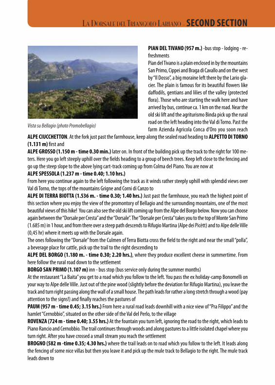
PIAN DEL TIVANO (957 m.) -bus stop - lodging - re-freshments Pian del Tivano is a plain enclosed in by the mountainsSan Primo, Cippei and Braga di Cavallo and on the westby “Il Dosso”, a big moraine left there by the Lario gla-cier. The plain is famous for its beautiful flowers likedaffodils, gentians and lilies of the valley (protectedflora). Those who are starting the walk here and havearrived by bus, continue ca. 1 km on the road. Near theold ski lift and the agriturismo Binda pick up the ruralroad on the left heading into the Val di Torno. Past thefarm Azienda Agricola Conca d’Oro you soon reach
ALPE CIUCCHETTON. At the fork just past the farmhouse, keep along the sealed road heading to ALPETTO DI TORNO(1.131 m) first and ALPE GROSSO (1.150 m - time 0.30 min.) later on. In front of the building pick up the track to the right for 100 me-ters. Here you go left steeply uphill over the fields heading to a group of beech trees. Keep left close to the fencing andgo up the steep slope to the above lying cart-track coming up from Colma del Piano. You are now at ALPE SPESSOLA (1.237 m - time 0.40; 1.10 hrs.)From here you continue again to the left following the track as it winds rather steeply uphill with splendid views overVal di Torno, the tops of the mountains Grigne and Corni di Canzo toALPE DI TERRA BIOTTA (1.536 m. - time 0.30; 1.40 hrs.) Just past the farmhouse, you reach the highest point ofthis section where you enjoy the view of the promontory of Bellagio and the surrounding mountains, one of the mostbeautiful views of this hike! You can also see the old ski lift coming up from the Alpe del Borgo below. Now you can chooseagain between the “Dorsale per Cresta” and the “Dorsale”. The “Dorsale per Cresta” takes you to the top of Monte San Primo(1.685 m) in 1 hour, and from there over a steep path descends to Rifugio Martina (Alpe dei Picètt) and to Alpe delle Ville(0,45 hr) where it meets up with the Dorsale again.The ones following the “Dorsale” from the Culmen of Terra Biotta cross the field to the right and near the small “polla”,a beverage place for cattle, pick up the trail to the right descending to ALPE DEL BORGO (1.180 m. - time 0.30; 2.20 hrs.), where they produce excellent cheese in summertime. Fromhere follow the rural road down to the settlementBORGO SAN PRIMO (1.107 m) inn - bus stop (bus service only during the summer months) At the restaurant “La Baita” you get to a road which you follow to the left. You pass the ex holiday-camp Bonomelli onyour way to Alpe delle Ville. Just out of the pine wood (slightly before the deviation for Rifugio Martina), you leave thetrack and turn right passing along the wall of a small house. The path leads for rather a long stretch through a wood (payattention to the signs!) and finally reaches the pastures ofPAUM (957 m - time 0.45; 3.15 hrs.) From here a rural road leads downhill with a nice view of “Pra Filippo” and thehamlet “Cernobbio”, situated on the other side of the Val del Perlo, to the villageROVENZA (724 m - time 0.40; 3.55 hrs.) At the fountain you turn left, ignoring the road to the right, which leads toPiano Rancio and Cernobbio. The trail continues through woods and along pastures to a little isolated chapel where youturn right. After you have crossed a small stream you reach the settlementBROGNO (582 m -time 0.35; 4.30 hrs.) where the trail leads on to road which you follow to the left. It leads alongthe fencing of some nice villas but then you leave it and pick up the mule track to Bellagio to the right. The mule trackleads down to
Vista su Bellagio (photo Promobellagio)
LA DORSALE DEL TRIANGOLO LARIANO - SECOND SECTION
BEGOLA (560 m - time 0.10; 4.40 hrs.) a clearing with two farmhouses, and then continues steeply downhill througha chestnut wood. You then arrive at the small village ofMULINI DEL PERLO (362 m - time 0.20; 5.00 hrs.) Cross the road, and pick up the large mule track to the left. Yousoon get to a fork where you turn right. You have a beautiful view on the pastures of Cagnanica down below. Past thefarmhouse, the track ends up in “Via Susanna” that you follow to the right. After 100 m, pick up the “Vicolo del Selvetto”to the right that leads down to Piazza S. Andrea in the hamletGUGGIATE (230 m - time 0.30; 5.3O hrs.) - refreshments available - bus stop - The trail finishes in this hamlet, 2 km from Bellagio. On the main road you find the bus stop either back to Como or toBellagio. It takes about 25 minutes by foot to the ferry dock of Bellagio.
LA DORSALE DEL TRIANGOLO LARIANO: LODGING AND RESTAURANT LIST
Always book before starting each section. The indicated opening days are not always respected
COMO 71 beds - service - open from 1/3 till 30/11 Youth Hostel “Villa Olmo” tel. 031 573800
CAPANNA C.A.O. 17 beds - restaurant service - open all year in winter weekends only0.45 min. from Brunate tel. 031 220221 - [email protected] - www.caocomo.it
BAITA CARLA 15 beds - restaurant service - open all year1.00 hr. from Brunate tel. 031 220186
BAITA BONDELLA 14 beds - restaurant service - Wednesday closed in winter open only for groups 1.15 hrs. from Brunate on reservation - tel. 031 220307 - www.baitabondella.it
BAITA BOLETTO FABRIZIO only restaurant service - open all year - closed on Friday1.20 hrs. from Brunate tel. 031 220235
RIFUGIO BOLETTONE 16 beds - restaurant serviceon the detour to Monte Bolettone tel. 031 6281633.00 from Brunate
CAPANNA MARA Restaurant service - Open on Sat, Sun- and holiday.on the detour from Monte Bolettone In August daily except Mondays - tel. 335 6776768
LA DORSALE DEL TRIANGOLO LARIANO - SECOND SECTION
RIFUGIO RIELLA 24 beds - restaurant service - open on Friday, Saturday and Sunday.4.00 hrs. from Brunate From Easter till October open from Wednesdays to Sundays - July and August daily
tel. 031 378600 or 031 378051 - 328 [email protected] - www.rifugioriella.it
Ristorante/ Bar COLMA DEL PIANO only restaurant serviceCapanna Stoppani open all year - closed on Thursday and from 1st to 25th Dec.5.20 hrs. from Brunate tel. 031 667051 - 3343150611
RIFUGIO ALPETTO DI TORNO 30 beds - restaurant - Always open on reservationPian del Tivano tel. 031 684313 - 3479190505
LA CONCA D’ORO 5 apartments - Min. stay 2 nights - open all yearPian del Tivano - 6.00 hrs. from Brunate tel. 031 677019 - [email protected]
AGRITURISMO BINDA Restaurant service - Closed on WedPian del Tivano - 6.00 hrs. from Brunate tel. 031 677057 - 331 5410899
ALBERGO “DOSSO” 24 beds - restaurant service - open all yearPian del Tivano tel. 031 917942 -fax 031 917967
RISTORANTE BAR CAMPEGGIO FUIN camping - open all year - closed on TuesdayPian del Tivano tel. 031 667059
RISTORANTE IL NUOVO MINISTRO only restaurant service - open all year - closed on FridayPian del Tivano tel. 031 667058
RISTORANTE LA BAITA only restaurant service - open all year - closet on Monday2.20 hrs. from Pian del Tivano tel. 031 964731
ALBERGO RISTORANTE GENZIANELLA 16 beds - restaurant service - open almost all year. Closed on Wed out of season2.30 hrs. from Pian del Tivano tel. 031 964734
RIFUGIO MARTINA restaurant service - open from half June till half September daily2.40 hrs. from Pian del Tivano rest of the year on Saturday and Sun - and holiday
tel. 031 964695
LA DORSALE DEL TRIANGOLO LARIANO - LODGING AND RESTAURANT LIST
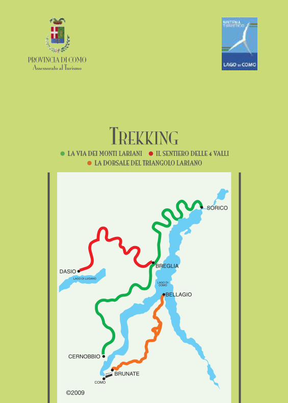
PROVINCIA DI COMOAssessorato al Turismo
PROVINCIA DI COMOAssessorato al Turismo
LA VIA DEI MONTI LARIANI IL SENTIERO DELLE QUATTRO VALLI LA DORSALE DEL TRIANGOLO LARIANO
LA VIA DEI MONTI LARIANI IL SENTIERO DELLE QUATTRO VALLI LA DORSALE DEL TRIANGOLO LARIANO
LAGO di COMOTREKKING
TREKKING
PROVINCIA DI COMOAssessorato al Turismo
TREKKING• LLAA VVIIAA DDEEII MMOONNTTII LLAARRIIAANNII • IILL SSEENNTTIIEERROO DDEELLLLEE 44 VVAALLLLII
• LLAA DDOORRSSAALLEE DDEELL TTRRIIAANNGGOOLLOO LLAARRIIAANNOO
©2009