Presentazione della SEZIONE GEODESIA E GEOMATICA · The GOCE mission SEDI Campus Leonardo...
29
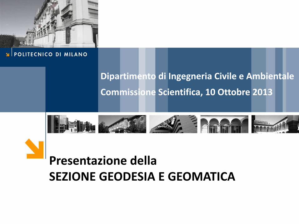
Presentazione della SEZIONE GEODESIA E GEOMATICA Dipartimento di Ingegneria Civile e Ambientale Commissione Scientifica, 10 Ottobre 2013
Transcript of Presentazione della SEZIONE GEODESIA E GEOMATICA · The GOCE mission SEDI Campus Leonardo...
Presentazione della SEZIONE GEODESIA E GEOMATICA
Dipartimento di Ingegneria Civile e Ambientale
Commissione Scientifica, 10 Ottobre 2013
The GOCE mission
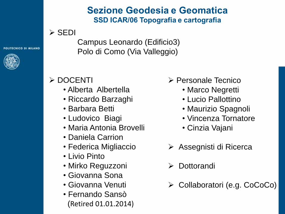
SEDI
Campus Leonardo (Edificio3)
Polo di Como (Via Valleggio)
DOCENTI
• Alberta Albertella
• Riccardo Barzaghi
• Barbara Betti
• Ludovico Biagi
• Maria Antonia Brovelli
• Daniela Carrion
• Federica Migliaccio
• Livio Pinto
• Mirko Reguzzoni
• Giovanna Sona
• Giovanna Venuti
• Fernando Sansò
(Retired 01.01.2014)
Personale Tecnico
• Marco Negretti
• Lucio Pallottino
• Maurizio Spagnoli
• Vincenza Tornatore
• Cinzia Vajani
Assegnisti di Ricerca
Dottorandi
Collaboratori (e.g. CoCoCo)

Alberta Albertella
PR Federica Migliaccio PA
Riccardo Barzaghi
PO Livio Pinto Responsabile di Sezione
PA
Barbara Betti
PO Mirko Reguzzoni PR
Daniela Carrion
PR Vincenza Tornatore EP
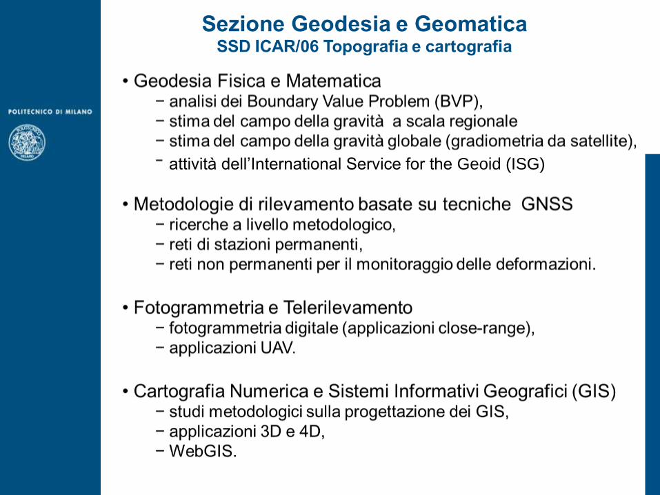
Sezione Geodesia e Geomatica SSD ICAR/06 Topografia e cartografia
Campus Leonardo (Edificio 3)

Ludovico Biagi
PR Giovanna Sona PR
Maria Antonia Brovelli
PO Giovanna Venuti PR
Fernando Sansò Retired 01.01.2014
PO Marco Negretti
Sezione Geodesia e Geomatica SSD ICAR/06 Topografia e cartografia
Polo di Como (Via Valleggio)
The GOCE mission
attività dell’International Service for the Geoid (ISG)
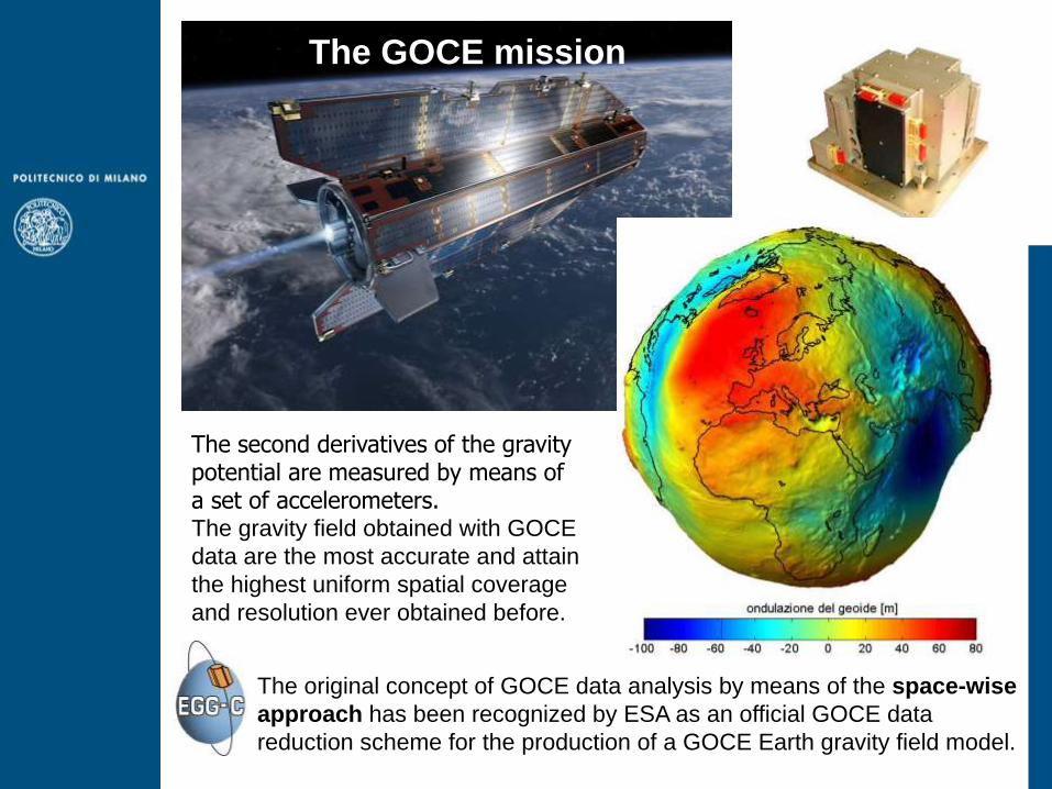
The original concept of GOCE data analysis by means of the space-wise
approach has been recognized by ESA as an official GOCE data
reduction scheme for the production of a GOCE Earth gravity field model.
The second derivatives of the gravity potential are measured by means of a set of accelerometers. The gravity field obtained with GOCE
data are the most accurate and attain
the highest uniform spatial coverage
and resolution ever obtained before.
The GOCE mission

Wiener
filter
SGG
data local
gridding
harmonic
analysis
SST
prior
model
model
coeffs
space-wise solver
filtered data gridded data
+ -
SST
prior
model
+
along track
synthesis
Wiener filter and GRF/LORF
corrections
The space-wise approach is a multi-step collocation procedure:
- data filtering along the orbit (Wiener filter) with iterative corrections,
- data gridding at satellite altitude (LS collocation),
- spherical harmonic analysis (numerical integration).
The Polimi space-wise approach for the GOCE mission

6.00 8.00 10.00 12.00 14.00 16.00 18.0036.00
38.00
40.00
42.00
44.00
46.00
The high precision Italian geoid (4 cm precision)
The Italian geoid estimate
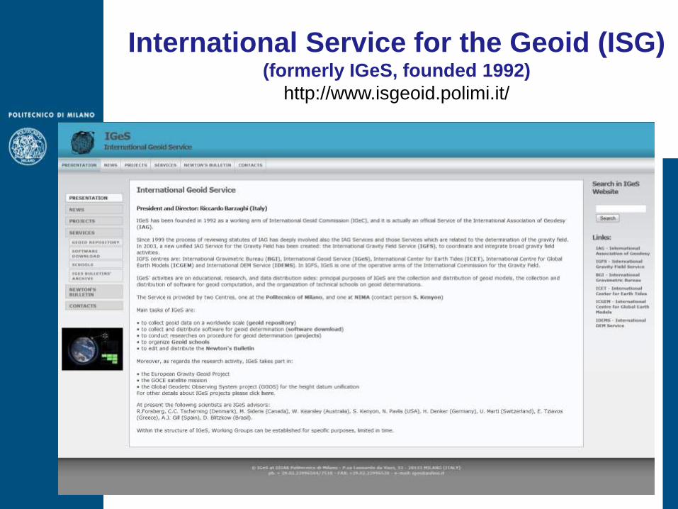
International Service for the Geoid (ISG) (formerly IGeS, founded 1992)
http://www.isgeoid.polimi.it/

International Service for the Geoid: OBJECTIVES
- collect geoid estimates worldwide,
- collect, test and, when allowed, distribute software for the geoid determination,
- conduct researches on methods for the geoid determination,
- organize schools on geoid determination,
- issue, at least once per year, the Newton’s Bulletin,
- disseminate special publications on geoid,
- support Agencies or scientists in computing regional geoids.
- METHODS AND TOOLS FOR MERGING LOCAL GEOID SOLUTIONS
- ANALYSES ON GLOBAL HEIGHT DATUM
- PLANS FOR NEW GEOID SCHOOLS (WITH BGI)
- NEW PROJECT FOR THE GEOID IN THE MEDITERRANEAN SEA
RECENT ACTIVITIES

Latest editions of Schools on geoid computation
- Politecnico di Milano, Como, Italy, September 15th -19th , 2008.
- Universidad Nacional de la Plata, Facultad de Ciencias Astronómicas
y Geofísicas, La Plata, Argentina, September 7th -11th , 2009.
- Research Institute ELEKTROPRIBOR, S.Peterburg, Russia, June 28th-
July 2nd, 2010.
- Universidad Técnica Particular de La Loja, Ecuador,
October 7th -11th , 2013 (11th International Geoid School).
Participants to the 1st International Geoid School, Milano, 10 - 14 October 1994

GPS Lombardia users
increase from 2005 to 2010
The Lombardia GPS-RTK network
-The network was designed and realized under the supervision of DIIAR
-18 GPS permanent GPS stations connected to a computing center
-It allows for precise positioning (5-6 cm precision) - It is the first network for real time applications in Italy

Permanent GPS networks for deformation monitoring
ALPS-GPSQUAKENET project
- The network has been designed for monitoring the
deformation of the Alpine area
- More than 35 GPS permanent stations have been
processed at DIIAR
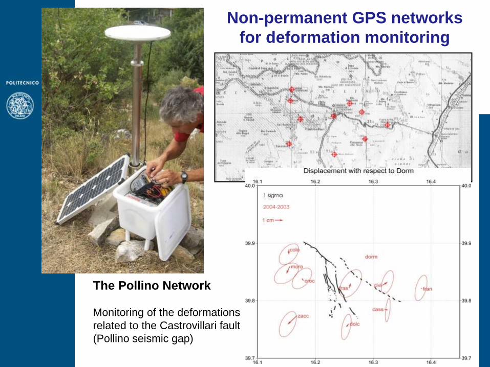
The Pollino Network
Monitoring of the deformations
related to the Castrovillari fault
(Pollino seismic gap)
Non-permanent GPS networks
for deformation monitoring

Geodetic link from CERN to INFN GS lab
CERN
730 km
INFN GS
INFN Gran Sasso Laboratories
Two semi-permanent GPS Networks ( )
a) Tunnel entrance (L’Aquila)
b) Tunnel entrance (Teramo)
It is necessary to know the entry point
coordinates and the two orientation points.
Perm. GPS Ant.
Tunnel (10.5 km)
TERAMO
L’AQUILA

Tunnel measurements
Theodolite TS 30 Leica
Angular rms = 0.5”
Distance rms = 0.5 mm + 0.5 ppm
DATUM WGS84
3D Coordinates
Traverse survey
Trellis pattern: 250/500 m
distance between points.
500 m
1-2
m
Geodetic survey at INFN GS lab

Tunnel measurements
500 m
1-2
m
Geodetic survey at INFN GS lab
Theodolite TS 30 Leica
Angular rms = 0.5”
Distance rms = 0.5 mm + 0.5 ppm

Accuracy
GPS baseline CERN - INFN = 1 cm
Traverse survey = 3 cm
Point inside the lab = 2-3 cm
Total acc. less than 4 cm Close Traverses
Geodetic survey at INFN GS lab
GNSS as a remote sensing system
for atmospheric sounding
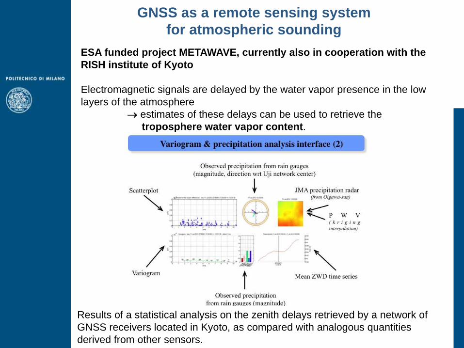
ESA funded project METAWAVE, currently also in cooperation with the
RISH institute of Kyoto
Electromagnetic signals are delayed by the water vapor presence in the low
layers of the atmosphere
estimates of these delays can be used to retrieve the
troposphere water vapor content.
Results of a statistical analysis on the zenith delays retrieved by a network of
GNSS receivers located in Kyoto, as compared with analogous quantities
derived from other sensors.

Villa Castelbarco
3D reconstruction from
photogrammetric takens and
topographic survey.
3D bas-relief reconstruction
with AGIsoft photoscan.
Photogrammetry: 3D Reconstruction
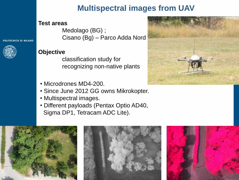
Multispectral images from UAV
Test areas
Medolago (BG) ;
Cisano (Bg) – Parco Adda Nord
Objective
classification study for
recognizing non-native plants
• Microdrones MD4-200.
• Since June 2012 GG owns Mikrokopter.
• Multispectral images.
• Different payloads (Pentax Optio AD40,
Sigma DP1, Tetracam ADC Lite).
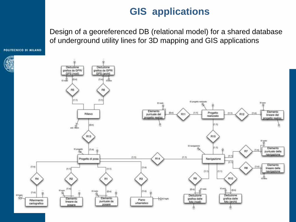
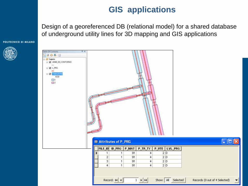
GIS applications Design of a georeferenced DB (relational model) for a shared database
of underground utility lines for 3D mapping and GIS applications
GIS applications Design of a georeferenced DB (relational model) for a shared database
of underground utility lines for 3D mapping and GIS applications

GIS applications
Structuring a georeferenced DB and implementing a GeoService for
historical research

GIS applications - WebGIS
Structuring a georeferenced DB and implementing a GeoService for
historical research
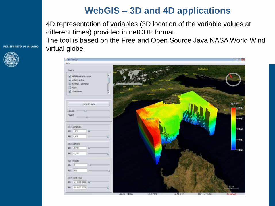
WebGIS – 3D and 4D applications
4D representation of variables (3D location of the variable values at
different times) provided in netCDF format.
The tool is based on the Free and Open Source Java NASA World Wind
virtual globe.

WebGIS – crowdsourcing
http://geomobile.como.polimi.it/segnalazioni_buche/istruzioni.html
An application which allows anyone to report road pavement damages events by
means of an Android device (e.g. smartphones and tablets) and to exploit the
device on-board sensors (GPS receiver and camera) to send georeferenced
images related to the road pavement damage events.
Data are stored inside a database, Web-published through standard protocols
and finally accessed in a dedicated WebGIS.

HeliDEM
The project was funded by the European Regional Development Fund within the
Italy-Switzerland cooperation program.
A unique DTM for the alpine and subalpine area between Italy (Piedmont and
Lombardy) and Switzerland (Ticino and Grisons Cantons) has been computed
starting from data acquired from different DTMs, in different reference frames
and obtained with different technologies, accuracies, and resolutions.
HELvetia-Italy Digital Elevation Model project
http://www.helidem.eu/

GReD http://www.g-red.eu/
GReD is a newly established Politecnico di Milano Spin-off which, based on
geomatics technologies, studies and designs innovative solutions, in:
• advanced surveying and cartography,
• augmented GNSS,
• high precision high resolution gravimetry,
• space applications.