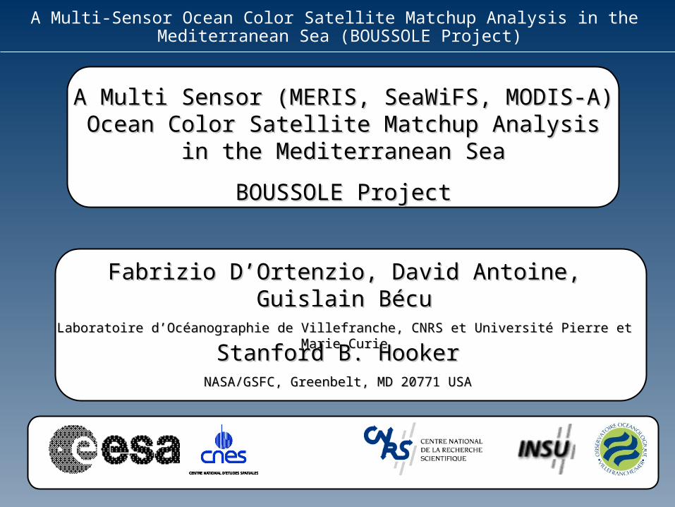
Fabrizio D’Ortenzio, David Antoine, Guislain Bécu
21
A Multi-Sensor Ocean Color Satellite Matchup Analysis in the Mediterranean Sea (BOUSSOLE Project) A Multi Sensor (MERIS, SeaWiFS, MODIS-A) A Multi Sensor (MERIS, SeaWiFS, MODIS-A) Ocean Color Satellite Matchup Analysis Ocean Color Satellite Matchup Analysis in the Mediterranean Sea in the Mediterranean Sea BOUSSOLE Project BOUSSOLE Project Fabrizio D’Ortenzio, David Antoine, Fabrizio D’Ortenzio, David Antoine, Guislain Bécu Guislain Bécu Laboratoire d’Océanographie de Villefranche, CNRS et Université Pierre et Laboratoire d’Océanographie de Villefranche, CNRS et Université Pierre et Marie Curie Marie Curie Stanford B. Hooker Stanford B. Hooker NASA/GSFC, Greenbelt, MD 20771 USA NASA/GSFC, Greenbelt, MD 20771 USA
-
Upload
alexandra-york -
Category
Documents
-
view
34 -
download
2
description
A Multi Sensor (MERIS, SeaWiFS, MODIS-A) Ocean Color Satellite Matchup Analysis in the Mediterranean Sea BOUSSOLE Project. Fabrizio D’Ortenzio, David Antoine, Guislain Bécu Laboratoire d’Océanographie de Villefranche, CNRS et Université Pierre et Marie Curie. Stanford B. Hooker - PowerPoint PPT Presentation
Transcript of Fabrizio D’Ortenzio, David Antoine, Guislain Bécu
A Multi-Sensor Ocean Color Satellite Matchup Analysis in the Mediterranean Sea (BOUSSOLE Project)
A Multi Sensor (MERIS, SeaWiFS, MODIS-A) A Multi Sensor (MERIS, SeaWiFS, MODIS-A) Ocean Color Satellite Matchup Analysis in the Ocean Color Satellite Matchup Analysis in the
Mediterranean SeaMediterranean Sea
BOUSSOLE ProjectBOUSSOLE Project
Fabrizio D’Ortenzio, David Antoine, Guislain BécuFabrizio D’Ortenzio, David Antoine, Guislain BécuLaboratoire d’Océanographie de Villefranche, CNRS et Université Pierre et Marie CurieLaboratoire d’Océanographie de Villefranche, CNRS et Université Pierre et Marie Curie
Stanford B. HookerStanford B. HookerNASA/GSFC, Greenbelt, MD 20771 USANASA/GSFC, Greenbelt, MD 20771 USA
A Multi-Sensor Ocean Color Satellite Matchup Analysis in the Mediterranean Sea (BOUSSOLE Project)
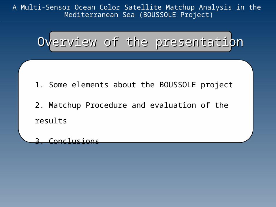
Overview of the presentationOverview of the presentation
1. Some elements about the BOUSSOLE project
2. Matchup Procedure and evaluation of the results
3. Conclusions
A Multi-Sensor Ocean Color Satellite Matchup Analysis in the Mediterranean Sea (BOUSSOLE Project)
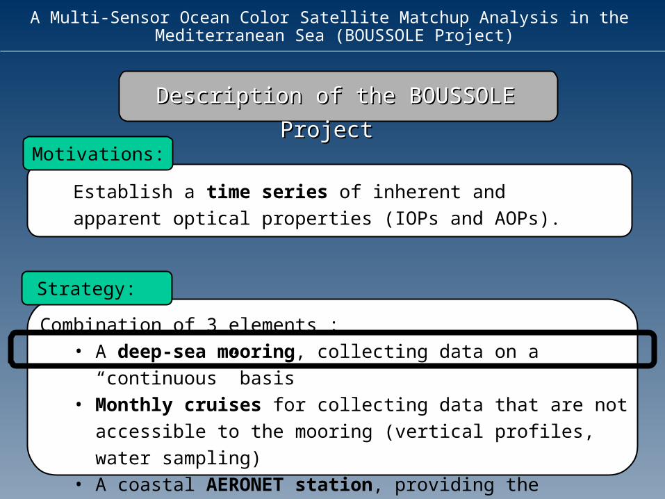
Description of the BOUSSOLE ProjectDescription of the BOUSSOLE Project
Establish a time series of inherent and apparent optical properties (IOPs and AOPs).
Motivations:
Combination of 3 elements :• A deep-sea mooring, collecting data on a “continuous”
basis• Monthly cruises for collecting data that are not
accessible to the mooring (vertical profiles, water sampling)
• A coastal AERONET station, providing the necessary information about the aerosol properties
Strategy:
A Multi-Sensor Ocean Color Satellite Matchup Analysis in the Mediterranean Sea (BOUSSOLE Project)
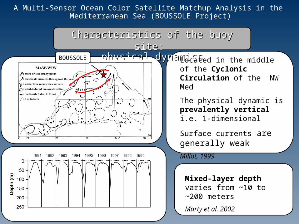
Characteristics of the buoy site: Characteristics of the buoy site: physical dynamicsphysical dynamics
Located in the middle of the Cyclonic Circulation of the NW Med
The physical dynamic is prevalently vertical i.e. 1-dimensional
Surface currents are generally weak
Millot, 1999
Mixed-layer depth varies from ~10 to ~200 meters
Marty et al. 2002
BOUSSOLE
A Multi-Sensor Ocean Color Satellite Matchup Analysis in the Mediterranean Sea (BOUSSOLE Project)
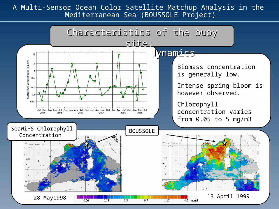
Characteristics of the buoy site: Characteristics of the buoy site: biological dynamicsbiological dynamics
Biomass concentration is generally low.
Intense spring bloom is however observed.
Chlorophyll concentration varies from 0.05 to 5 mg/m3
SeaWiFS Chlorophyll Concentration
BOUSSOLE
13 April 199928 May1998
A Multi-Sensor Ocean Color Satellite Matchup Analysis in the Mediterranean Sea (BOUSSOLE Project)
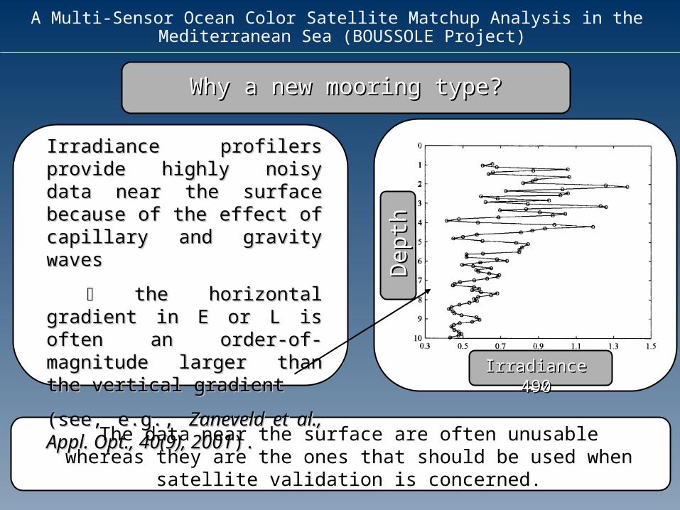
Why a new mooring type?Why a new mooring type?
Irradiance profilers provide Irradiance profilers provide highly noisy data near the highly noisy data near the surface because of the surface because of the effect of capillary and effect of capillary and gravity wavesgravity waves
the horizontal gradient in the horizontal gradient in E or L is often an order-of-E or L is often an order-of-magnitude larger than the magnitude larger than the vertical gradient vertical gradient
(see, e.g., (see, e.g., Zaneveld et al., Zaneveld et al., Appl. Opt., 40(9), 2001Appl. Opt., 40(9), 2001).).
The data near the surface are often unusable whereas they are the ones that should be used when satellite validation
is concerned.
Depth
Dep
th
Irradiance 490Irradiance 490
A Multi-Sensor Ocean Color Satellite Matchup Analysis in the Mediterranean Sea (BOUSSOLE Project)
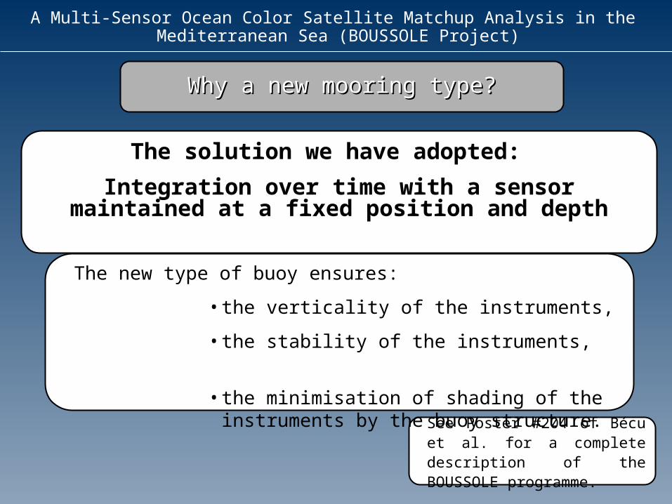
The new type of buoy ensures:
•the verticality of the instruments,
•the stability of the instruments,
•the minimisation of shading of the instruments by the buoy structure.
Why a new mooring type?Why a new mooring type?
The solution we have adopted:
Integration over time with a sensor maintained at a fixed position and depth
See Poster #204 of Bécu et al. for a complete description of the BOUSSOLE programme.

A Multi-Sensor Ocean Color Satellite Matchup Analysis in the Mediterranean Sea (BOUSSOLE Project)
Surface irradiance (Es) Downwelling irradiance (Ed) Upwelling irradiance (Eu)Upwelling radiance at nadir (Lu)
Measurement suite, instrumentationMeasurement suite, instrumentation
Attenuation coefficientBackscattering coefficient Chlorophyll fluorescenceTemperature,PressureSalinityBuoy tilt
At 4 and 9 meters At 9 meters
Wetlabs C-star2 s, Hobilabs’ HydroscatChelsea MiniTrackaSeaBird’ SBE37
7 s Satlantic’ OCR-OCI 200
Series
Fully normalized reflectances w (defined as nLw/Es )
Water leaving radiances Lwn
+4 meters
-20 meters
A Multi-Sensor Ocean Color Satellite Matchup Analysis in the Mediterranean Sea (BOUSSOLE Project)
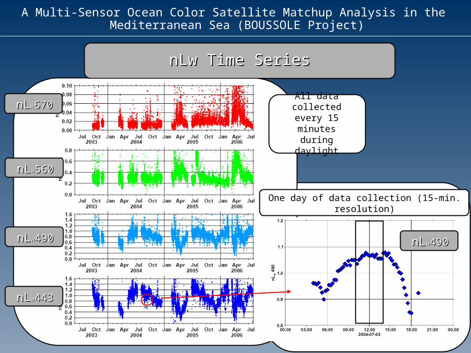
nLw Time SeriesnLw Time Series
All data collected every
15 minutes during daylight
One day of data collection (15-min. resolution)
nLnLww443443
nLnLww490490
nLnLww560560
nLnLww670670
nLnLww490490
A Multi-Sensor Ocean Color Satellite Matchup Analysis in the Mediterranean Sea (BOUSSOLE Project)
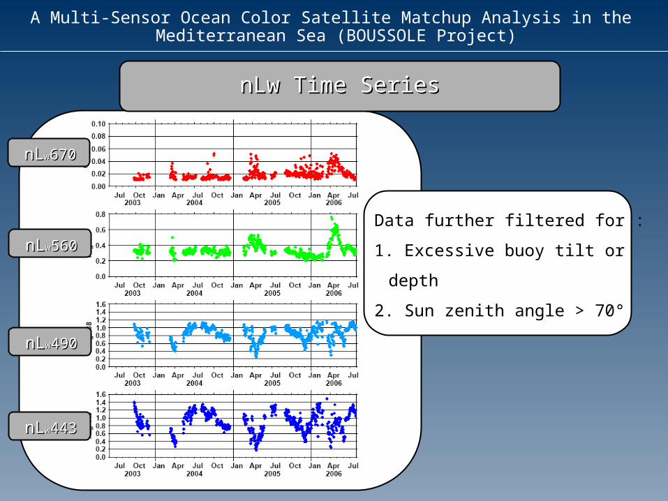
nLw Time SeriesnLw Time Series
Data further filtered for :
1. Excessive buoy tilt or depth
2. Sun zenith angle > 70°
nLnLww443443
nLnLww490490
nLnLww560560
nLnLww670670
A Multi-Sensor Ocean Color Satellite Matchup Analysis in the Mediterranean Sea (BOUSSOLE Project)
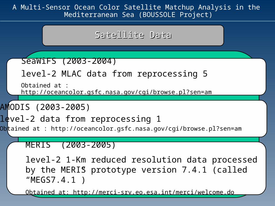
SeaWiFS (2003-2004)
level-2 MLAC data from reprocessing 5 Obtained at : http://oceancolor.gsfc.nasa.gov/cgi/browse.pl?sen=am
Satellite DataSatellite Data
MERIS (2003-2005)
level-2 1-Km reduced resolution data processed by the MERIS prototype version 7.4.1 (called “MEGS7.4.1”)Obtained at: http://merci-srv.eo.esa.int/merci/welcome.do
AMODIS (2003-2005)level-2 data from reprocessing 1Obtained at : http://oceancolor.gsfc.nasa.gov/cgi/browse.pl?sen=am
A Multi-Sensor Ocean Color Satellite Matchup Analysis in the Mediterranean Sea (BOUSSOLE Project)
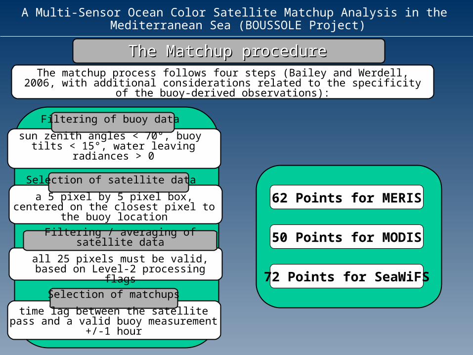
The Matchup procedureThe Matchup procedureThe matchup process follows four steps (Bailey and Werdell, 2006, with additional considerations related to the specificity of the buoy-derived
observations):
Filtering of buoy data
sun zenith angles < 70°, buoy tilts < 15°, water leaving radiances > 0
Selection of satellite data
a 5 pixel by 5 pixel box, centered on the closest pixel to the buoy location
Filtering / averaging of satellite data
all 25 pixels must be valid, based on Level-2 processing flags
Selection of matchups
time lag between the satellite pass and a valid buoy measurement +/-1 hour
62 Points for MERIS
50 Points for MODIS
72 Points for SeaWiFS
A Multi-Sensor Ocean Color Satellite Matchup Analysis in the Mediterranean Sea (BOUSSOLE Project)
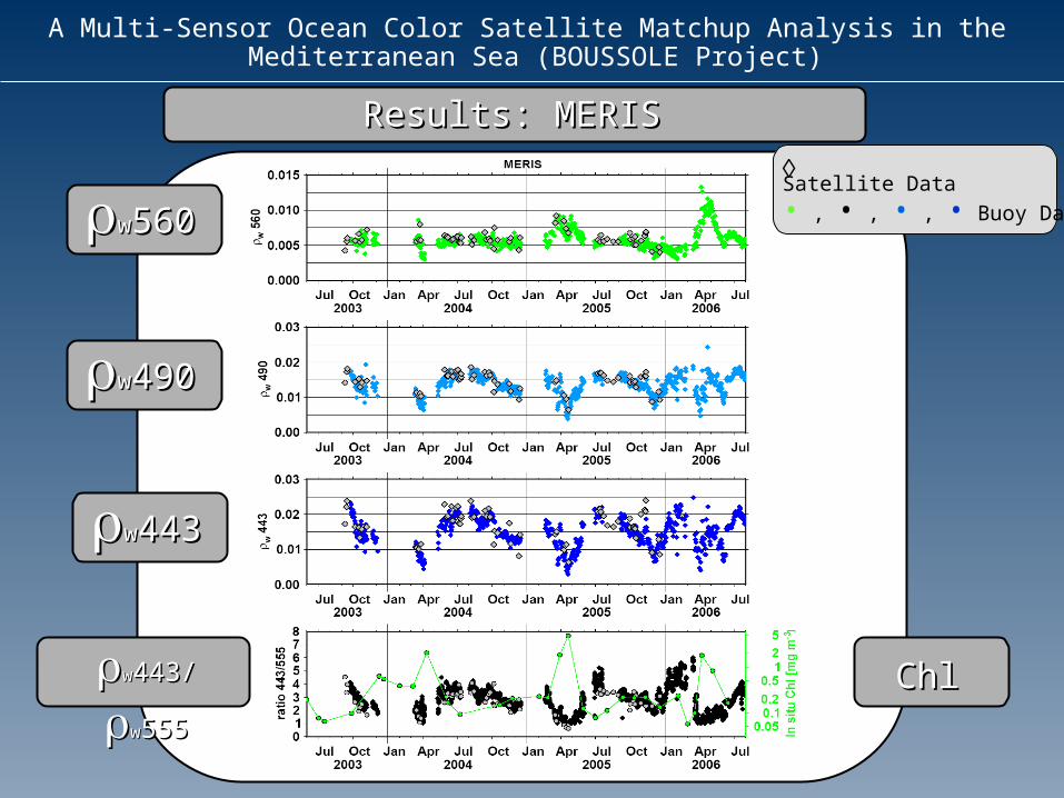
Results: MERISResults: MERIS Satellite Data
• , • , • , • Buoy Dataww560560
ww490490
ww443443
ww443/ 443/ ww555555 ChlChl
A Multi-Sensor Ocean Color Satellite Matchup Analysis in the Mediterranean Sea (BOUSSOLE Project)
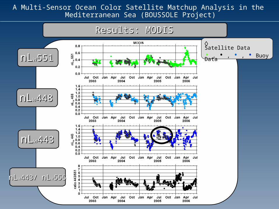
Results: MODISResults: MODIS
nLnLww551551
nLnLww448448
nLnLww443443
nLnLww443/ 443/ nLnLww555555
Satellite Data
• , • , • , • Buoy Data
A Multi-Sensor Ocean Color Satellite Matchup Analysis in the Mediterranean Sea (BOUSSOLE Project)
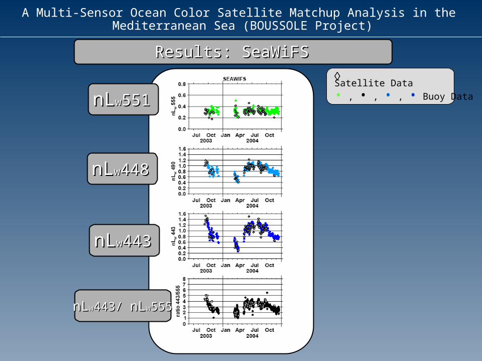
Results: SeaWiFSResults: SeaWiFS
nLnLww551551
nLnLww448448
nLnLww443443
nLnLww443/ 443/ nLnLww555555
Satellite Data
• , • , • , • Buoy Data
A Multi-Sensor Ocean Color Satellite Matchup Analysis in the Mediterranean Sea (BOUSSOLE Project)
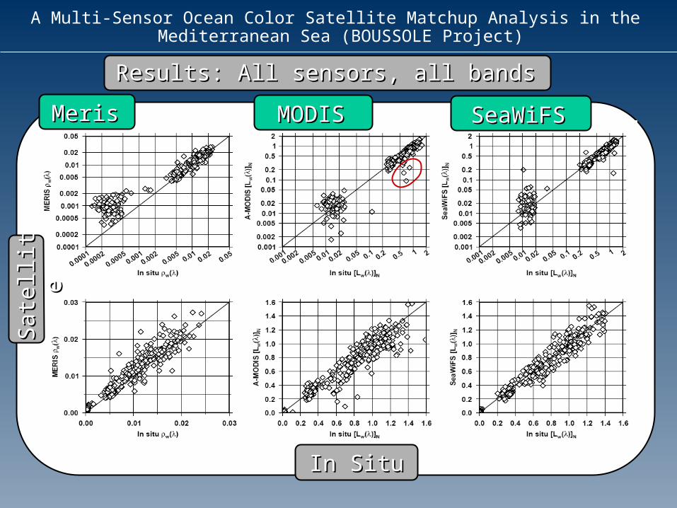
Results: All sensors, all bandsResults: All sensors, all bands
MerisMeris
In SituIn Situ
MODISMODIS SeaWiFSSeaWiFS
Sate
llite
Sate
llite
A Multi-Sensor Ocean Color Satellite Matchup Analysis in the Mediterranean Sea (BOUSSOLE Project)
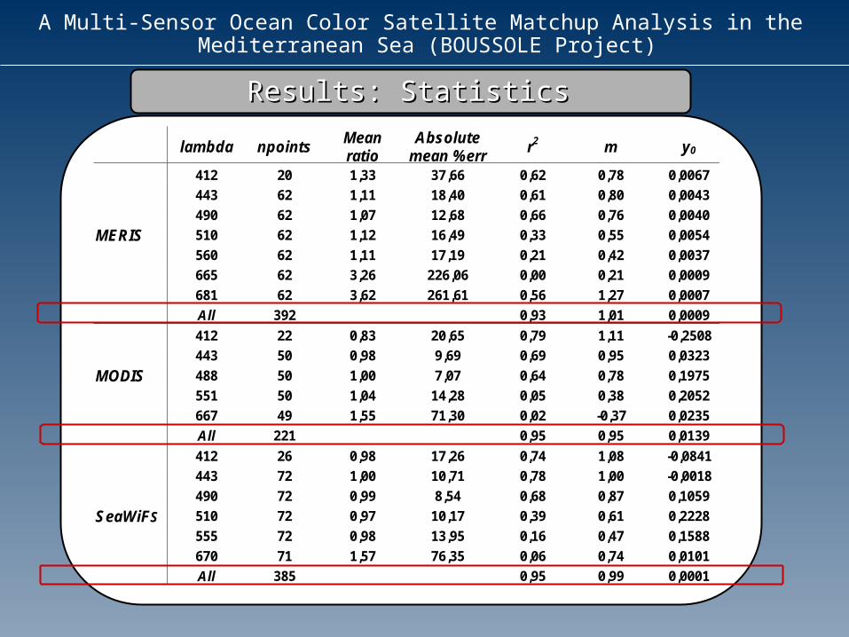
Results: StatisticsResults: Statistics
lambda npointsMeanratio
Absolutemean %err
r2 m y0
412 20 1,33 37,66 0,62 0,78 0,0067
443 62 1,11 18,40 0,61 0,80 0,0043
490 62 1,07 12,68 0,66 0,76 0,0040
MERIS 510 62 1,12 16,49 0,33 0,55 0,0054
560 62 1,11 17,19 0,21 0,42 0,0037
665 62 3,26 226,06 0,00 0,21 0,0009
681 62 3,62 261,61 0,56 1,27 0,0007
All 392 0,93 1,01 0,0009
412 22 0,83 20,65 0,79 1,11 -0,2508
443 50 0,98 9,69 0,69 0,95 0,0323
MODIS 488 50 1,00 7,07 0,64 0,78 0,1975
551 50 1,04 14,28 0,05 0,38 0,2052
667 49 1,55 71,30 0,02 -0,37 0,0235
All 221 0,95 0,95 0,0139
412 26 0,98 17,26 0,74 1,08 -0,0841
443 72 1,00 10,71 0,78 1,00 -0,0018
490 72 0,99 8,54 0,68 0,87 0,1059
SeaWiFS 510 72 0,97 10,17 0,39 0,61 0,2228
555 72 0,98 13,95 0,16 0,47 0,1588
670 71 1,57 76,35 0,06 0,74 0,0101
All 385 0,95 0,99 0,0001
A Multi-Sensor Ocean Color Satellite Matchup Analysis in the Mediterranean Sea (BOUSSOLE Project)
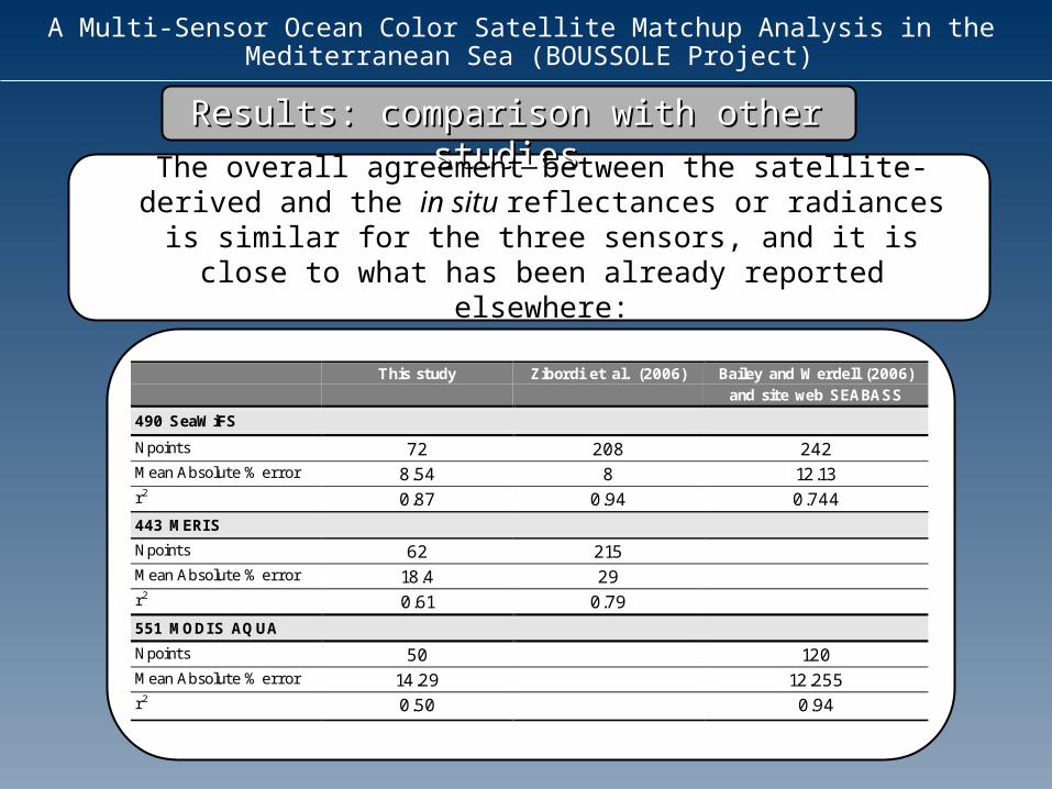
Results: comparison with other Results: comparison with other studiesstudies
The overall agreement between the satellite-derived and the in situ reflectances or radiances is similar for
the three sensors, and it is close to what has been already reported elsewhere:
This study Zibordi et al. (2006) Bailey and Werdell (2006)and site web SEABASS
490 SeaWiFS
Npoints 72 208 242Mean Absolute % error 8.54 8 12.13r2 0.87 0.94 0.744
443 MERIS
Npoints 62 215Mean Absolute % error 18.4 29r2 0.61 0.79
551 MODIS AQUA
Npoints 50 120Mean Absolute % error 14.29 12.255r2 0.50 0.94
A Multi-Sensor Ocean Color Satellite Matchup Analysis in the Mediterranean Sea (BOUSSOLE Project)
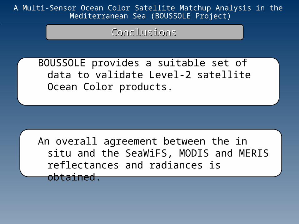
ConclusionsConclusions
BOUSSOLE provides a suitable set of data to validate Level-2 satellite Ocean Color products.
An overall agreement between the in situ and the SeaWiFS, MODIS and MERIS reflectances and radiances is obtained.
A Multi-Sensor Ocean Color Satellite Matchup Analysis in the Mediterranean Sea (BOUSSOLE Project)
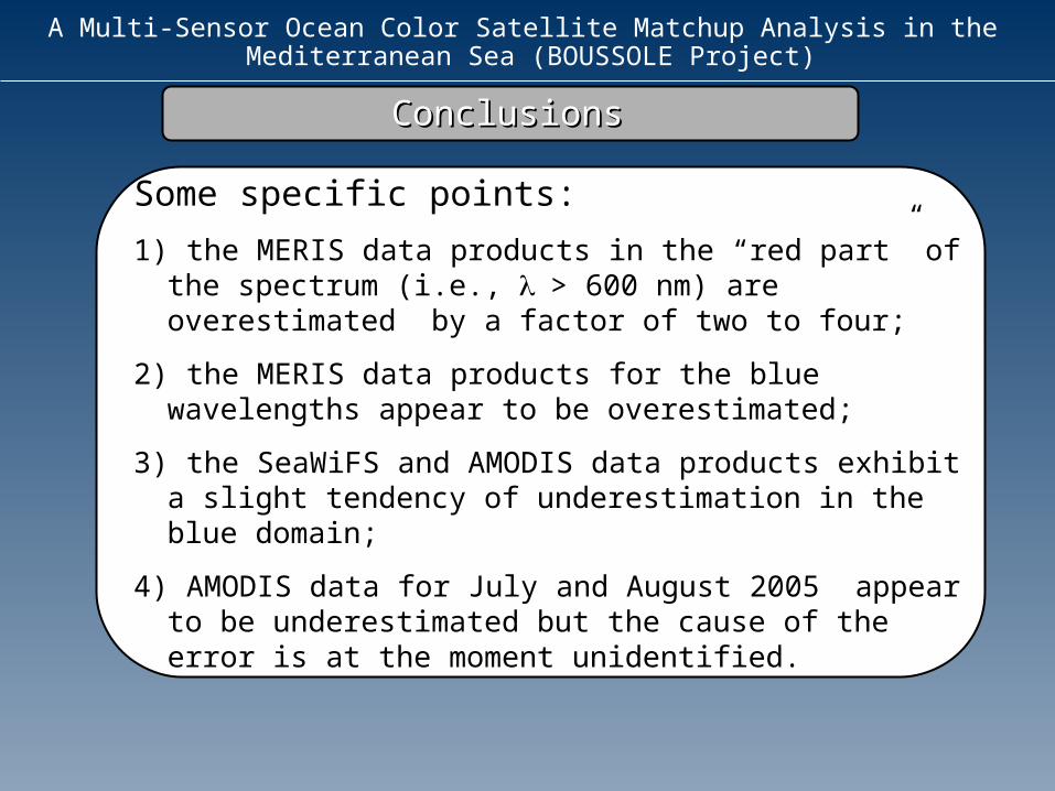
ConclusionsConclusions
Some specific points:
1) the MERIS data products in the “red part” of the spectrum (i.e., > 600 nm) are overestimated by a factor of two to four;
2) the MERIS data products for the blue wavelengths appear to be overestimated;
3) the SeaWiFS and AMODIS data products exhibit a slight tendency of underestimation in the blue domain;
4) AMODIS data for July and August 2005 appear to be underestimated but the cause of the error is at the moment unidentified.
A Multi-Sensor Ocean Color Satellite Matchup Analysis in the Mediterranean Sea (BOUSSOLE Project)
Thank you for your attention