Development of a geodatabase for the central … sessione IX... · Pietro MOSCA1, Chiara GROPPO2,1...
22
Pietro MOSCA 1 , Chiara GROPPO 2,1 & Franco ROLFO 2,1 ( 1 )CNR-Istituto di Geoscienze e Georisorse, Torino ( 2 ) Dip. Scienze della Terra, Univ. Torino Development of a geodatabase for the central-eastern Himalayas X Convegno Nazionale "GIT- Geosciences and Information Technologies“ 17 - 19 Giugno 2015, San Leo (RN) GIT, 2015
Transcript of Development of a geodatabase for the central … sessione IX... · Pietro MOSCA1, Chiara GROPPO2,1...
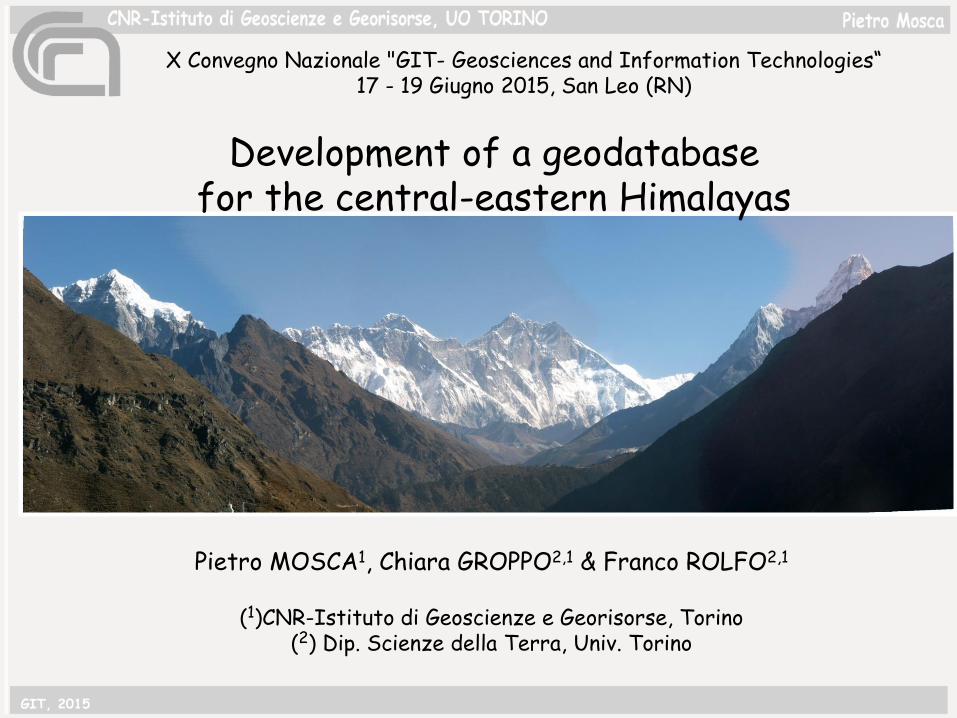
Pietro MOSCA1, Chiara GROPPO2,1 & Franco ROLFO2,1
(1)CNR-Istituto di Geoscienze e Georisorse, Torino(2) Dip. Scienze della Terra, Univ. Torino
Development of a geodatabase for the central-eastern Himalayas
X Convegno Nazionale "GIT- Geosciences and Information Technologies“17 - 19 Giugno 2015, San Leo (RN)
GIT, 2015

….“modern” geologic mapping cannot be only considered as simple digital/graphic representation of rock distributions, but it is an expression “of several type of data” collected, elaborated and interpreted “at that time” …. So, description and storing of data play a fundamental and strategic role in geologic mapping standard models and standard vocabulary are then required (GeosciML…)
Geologic mapping
GIT, 2015
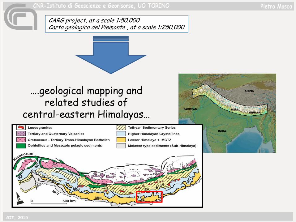
CARG project, at a scale 1:50.000Carta geologica del Piemonte , at a scale 1:250.000
….geological mapping and related studies of
central-eastern Himalayas…
GIT, 2015

Working at a regional scale imposes a correct data management and storing of all these data• data quality•data traceability...and these are fundamental steps for correlation through the chain
TORINO working group collected a large amount of data (quantitative) in the central-eastern Himalayas
in the framework of different activities and projects.Field: structural to lithological data, rock samples, water samples
Labs: thin sections, geochemical analyses geological maps (at different scales)
…..Old (‘70s) and new data
GIT, 2015
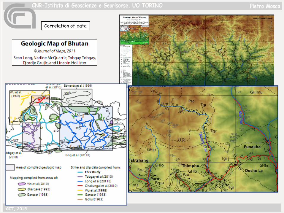
Correlation of data
GIT, 2015

Working at a regional scale imposes a correct data management and storing of all these data• data quality•data traceability...and these are fundamental steps for correlation through the chain
1) Semantic harmonization2)geometric/topologic harmonization
Geological Knowledge transfer by using Description Standards:
GeoSciML vocabulary
Digital structure (.shp)
DB with Descriptive standards
Geodatabase
GIT, 2015
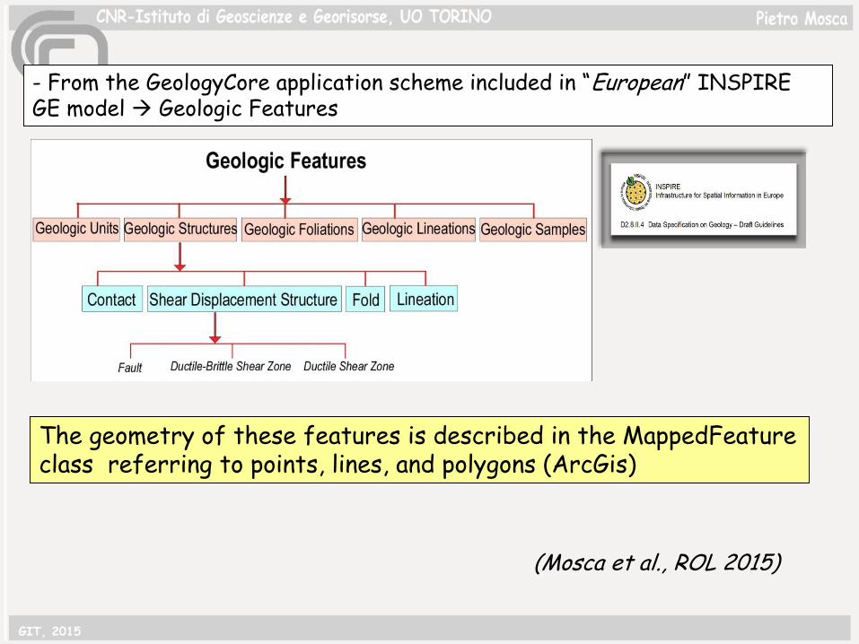
- From the GeologyCore application scheme included in “European” INSPIRE GE model Geologic Features
The geometry of these features is described in the MappedFeature class referring to points, lines, and polygons (ArcGis)
(Mosca et al., ROL 2015)
GIT, 2015
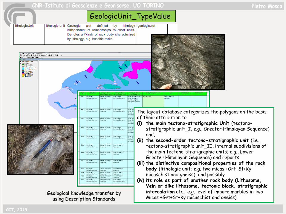
Geological Knowledge transfer by using Description Standards
GeologicUnit_TypeValue
The layout database categorizes the polygons on the basis of their attribution to (i) the main tectono-stratigraphic Unit (tectono-
stratigraphic unit_I, e.g., Greater Himalayan Sequence) and,
(ii) the second-order tectono-stratigraphic unit (i.e. tectono-stratigraphic unit_II, internal subdivisions of the main tectono-stratigraphic units; e.g., Lower Greater Himalayan Sequence) and reports
(iii) the distinctive compositional properties of the rock body (lithologic unit; e.g. two micas +Grt+St+Kymicaschist and gneiss), and possibly
(iv) its role as part of another rock body (Lithosome, Vein or dike lithosome, tectonic block, stratigraphicintercalation etc.; e.g. level of impure marbles in two Micas +Grt+St+Ky micaschist and gneiss).
GIT, 2015
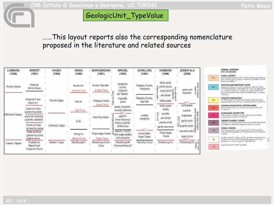
……This layout reports also the corresponding nomenclature proposed in the literature and related sources
GeologicUnit_TypeValue
GIT, 2015

The geological structures include three feature classes: ShearDisplacementStructure (brittle to ductile faults), Fold, and Contact.
GIT, 2015

The Contact class is an extension to the core model and represents the geological contacts. Graphically it corresponds to the lines that involve each of the polygons of the mapped lithological units.
Ex Igneous intrusive contact
gneiss
leucogranites
GIT, 2015
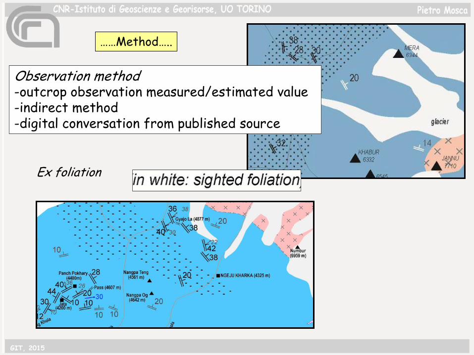
Observation method-outcrop observation measured/estimated value-indirect method-digital conversation from published source
Ex foliation
……Method…..
GIT, 2015
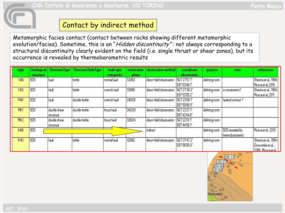
Metamorphic facies contact (contact between rocks showing different metamorphic evolution/facies). Sometime, this is an “Hidden discontinuity” : not always corresponding to a structural discontinuity clearly evident on the field (i.e. single thrust or shear zones), but its occurrence is revealed by thermobarometric results
Contact by indirect method
GIT, 2015
Rock Samples, water samples and their labs analyses
50 km
…..Old (‘70s) and new data
GIT, 2015
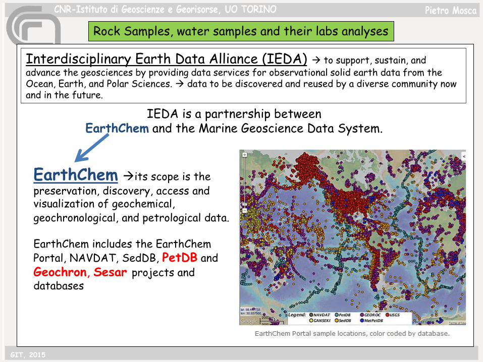
Interdisciplinary Earth Data Alliance (IEDA) to support, sustain, and advance the geosciences by providing data services for observational solid earth data from the Ocean, Earth, and Polar Sciences. data to be discovered and reused by a diverse community now and in the future.
IEDA is a partnership between EarthChem and the Marine Geoscience Data System.
EarthChem its scope is the preservation, discovery, access and visualization of geochemical, geochronological, and petrological data.
EarthChem includes the EarthChem Portal, NAVDAT, SedDB, PetDB and Geochron, Sesar projects and databases
GIT, 2015
Rock Samples, water samples and their labs analyses
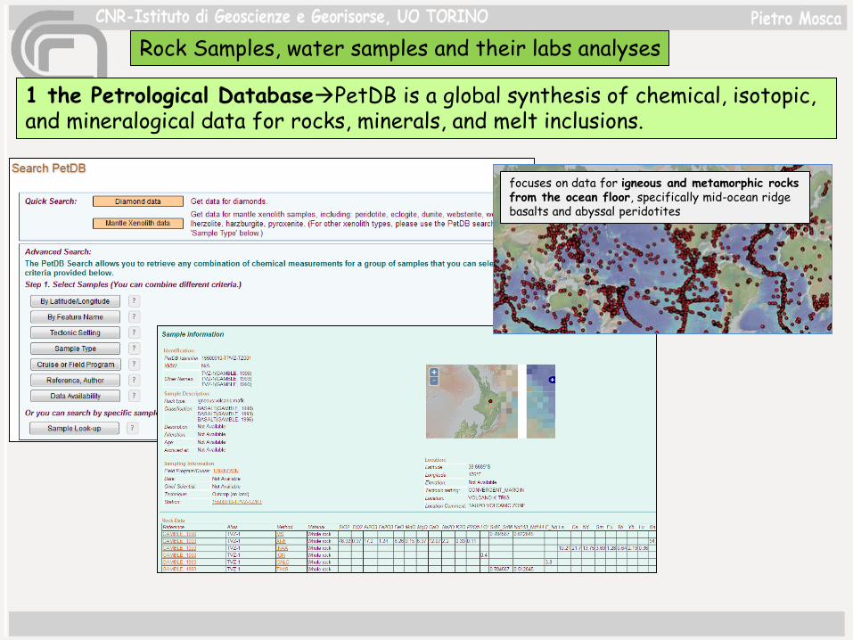
1 the Petrological DatabasePetDB is a global synthesis of chemical, isotopic, and mineralogical data for rocks, minerals, and melt inclusions.
focuses on data for igneous and metamorphic rocks from the ocean floor, specifically mid-ocean ridge basalts and abyssal peridotites
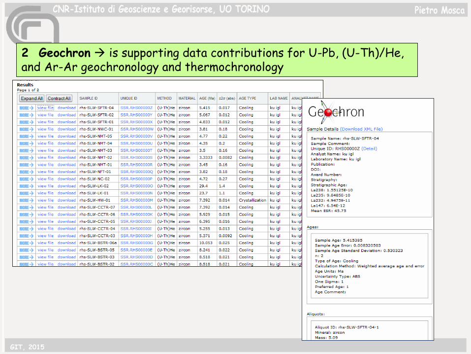
2 Geochron is supporting data contributions for U-Pb, (U-Th)/He, and Ar-Ar geochronology and thermochronology
GIT, 2015
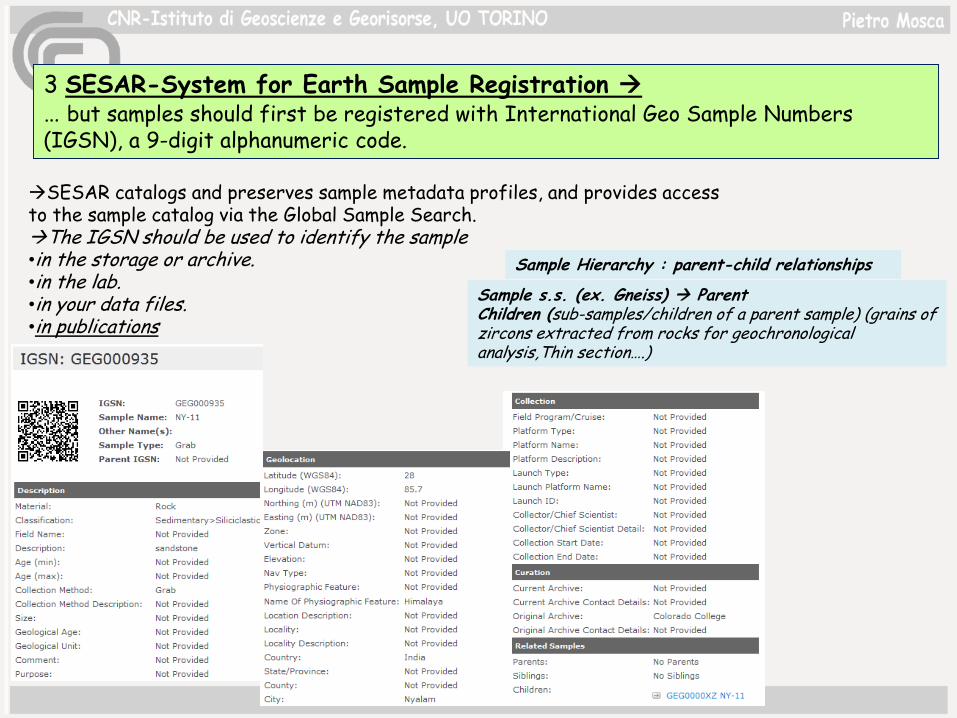
3 SESAR-System for Earth Sample Registration … but samples should first be registered with International Geo Sample Numbers (IGSN), a 9-digit alphanumeric code.
Sample Hierarchy : parent-child relationships
SESAR catalogs and preserves sample metadata profiles, and provides access to the sample catalog via the Global Sample Search.The IGSN should be used to identify the sample•in the storage or archive.•in the lab.•in your data files.•in publications
Sample s.s. (ex. Gneiss) ParentChildren (sub-samples/children of a parent sample) (grains of zircons extracted from rocks for geochronologicalanalysis,Thin section….)
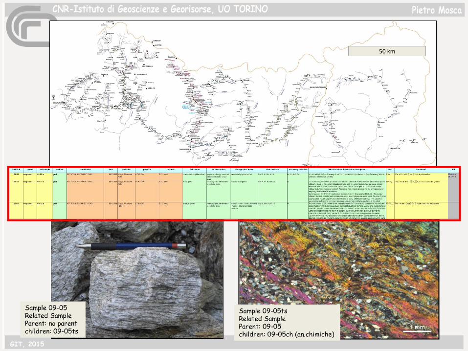
50 km
Sample 09-05Related SampleParent: no parentchildren: 09-05ts
Sample 09-05tsRelated SampleParent: 09-05children: 09-05ch (an.chimiche)
GIT, 2015
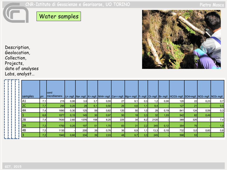
Water samples
Description, Geolocation, Collection, Projects, date of analysesLabs, analyst…
GIT, 2015

“classical” papers (where geological maps, petrographic-chemical data are presented) are linked to an uniform /standard storage of data (…..Geodatabase…)
GIT, 2015
-Geologic map is expression of databases-Earth Science community needs standard models and vocabularies for the storage and exchange of geological data: this is the base for cooperation and projects development, and discovery of existing data (publications) -For samples: databases of EarthChem projects allow users to quickly and easily access comprehensive data sets over the web, and to extract subsets that include data from any number of publications based on queries customized to an investigator’s interests. -in addition, this helps to preserve and valorize geologic data obtained/collected with time and economic efforts-……but this is not yet seen as a necessity for most of the scientific community
- ……..la nostra gelosia del dato…..
GIT, 2015

Langtang, aprile 2015
grazie
GIT, 2015